
Jeff Mitchell's Blog, page 8
October 20, 2023
Vistas of Moosic Mountain-SGL 300
 Incredible views from Moosic Mountain
Length: Approx. 3 miles
Difficulty: Easy to moderate.
Trails: This hike follows jeep roads and an unblazed trail. No trails have signs or blazes.
Parking: A lot is here 41.517442, -75.472724. Road is only open during hunting season. Road was in good shape when I drove it.
Highlights: Extensive views. You can even see the Catskills! Blueberry meadows, heath barrens.
Issues: Wear orange during hunting season.
Best time to hike: Blueberry meadows turn red in mid October. Wildflowers in late spring and summer.
Description: Moosic Mountain is a local treasure and a very unique mountain. It is a broad sloping ridge that resembles more of a plateau. It has the largest heath barrens in the east and is home to several rare species. Most people visit Moosic Mountain at the beautiful Eales Preserve. However, this hike has views that are superior to Eales. The hiking here is also more isolated and natural, as it is further away from urban areas than Eales.
This is by far the finest hike near Scranton for views. I was impressed. From the parking area, follow the jeep road as it makes a gradual climb across meadows and past pine trees. Descend gradually and a gravel jeep road joins from the right, this is your return route. Begin another gradual climb as views open in all directions. Reach the height of the ridge and enjoy views over the ridge of red blueberry meadows. Begin a gradual descent.
Keep an eye out for an obvious trail that makes a sharp right, you will take this. For now, continue straight across the blueberry meadows. This is spectacular on bright sunny days during peak red foliage. I turned around at a spot with almost a 360 degree view. Return to the trail I mentioned earlier. Now turn left on the trail and climb gradually. Enjoy the views. The peak of Elk Mountain rises to the north. Reach a grove of pine trees. Notice a faint trail through the pine, it ends at a stunning vista to the north and east. You can even see the Catskills. Do not miss this view.
Continue south on the trail. This trail is followable, but brushy. Enjoy more meadows and occasional views. The trail can get faint, but you can follow it as it stays near the top of the ridge. Reach the gravel jeep road. Turn right and then turn left onto the next jeep road. Retrace your steps back to the car.
 Gray is the jeep roads. Yellow is the unblazed trail which becomes more brushy as you head south. Red is a short unblazed side trail to a stunning view. No trails are marked.
 View this post on InstagramA post shared by Jeff Mitchell-Outdoors Author (@hiking_mitch)
View this post on InstagramA post shared by Jeff Mitchell-Outdoors Author (@hiking_mitch)
View this post on InstagramA post shared by Jeff Mitchell-Outdoors Author (@hiking_mitch)
View this post on InstagramA post shared by Jeff Mitchell-Outdoors Author (@hiking_mitch)
View this post on InstagramA post shared by Jeff Mitchell-Outdoors Author (@hiking_mitch)
View this post on InstagramA post shared by Jeff Mitchell-Outdoors Author (@hiking_mitch)


October 16, 2023
Backpacking the Susquehannock Trail System (STS)
 Cherry Springs Vista, just off the STS
Length: 84 mile loop. The longest loop trail in the east.
Blazes: The STS is blazed orange, side trails are often yellow or red.
Duration: 4-8 days to do the entire trail as a thruhike.
History: The trail was built in 1968, making it one of the older backpacking trails in the country.
Difficulty: Varied. Easy to difficult. The STS is easier than the Black Forest Trail, but harder than the West Rim Trail, Old Loggers Path, or Allegheny Front Trail.
Terrain: The STS has plenty of ups and downs, but they tend to be gradual. Climbs and descents can reach a thousand vertical feet. The trail also has plenty of rolling and level sections. Cardiac Climb is the most famous steep part, but Morgan Hollow, near Left Branch Young Womens Creek, is much more challenging and is the steepest part of the STS.
Trail conditions: The trail is generally well marked and maintained. There are brushy sections, particularly in the Hammersley Wild Area north of the pool. There are some wet areas. The trail has no significant rocky areas or scrambling. It is often a fairly smooth trail. There are many stream crossings and several have bridges. Many trail junctures have signs.
Amenities: The STS has seven shelters and one small hut. Ole Bull State Park has water, bathrooms, camping and showers (fee applies), even a beach and swimming area. Cross Fork has Deb’s, a bar/restaurant, a small general store, and a post office to mail resupply boxes. There are also small hotels in Cross Fork. Lyman Run State Park is a short hike from the trail. It has a beach and swimming area, showers and camping (fee applies), and a seasonal snack shop.
Trailheads: The STS crosses many roads with small parking areas. The three main trailheads are the Northern Gateway/ Susquehannock Forest office 41.768418, -77.869546 , Ole Bull State Park 41.538682, -77.714718 , Cross Fork/Susquehannock Forest building 41.482110, -77.818396 . Make sure you leave your contact and vehicle information.
Fees/permits: None. Large backpacking groups (over 10, I believe) may need approval from the Susquehannock State Forest.
Which way to hike? I think the best route is clockwise from the Northern Gateway. This puts Cross Fork roughly half way where you can get a meal, resupply, or even a room.
Water: Generally common. However, the STS crosses many small streams that are dry in summer. Water quality is usually good.
Shelters: The STS has some of the nicest shelters I’ve seen on any trail. They often have furniture, like chairs and picnic tables. Some shelters are in dry locations and the Susquehannock Trail Club tries to cache water at those shelters, but it is not guaranteed. The shelters are as follows:
Dynamite House (small hut). Usually dry. Historical interest. Very dark inside.
Bolich Run Shelter. A favorite shelter of mine. Located in a meadow with a hemlock shaded creek nearby. There is even an open air privy.
Spook Hollow Shelter. Dry. A great place to stay over Halloween.
Scoval Branch Shelter. There is water, but it is swampy. Better water is downstream a half mile. Beautiful location.
Gravel Lick Shelter. Dry. Located very close to McConnell Road. Secret hint: walk McConnell Road east a few hundred feet to beautiful Hammersley Vista, great for sunrises.
Wild Boy Shelter. Another favorite. Isolated. Creeks nearby, even a spring that cascades over a rock outcrop.
Ford Hollow Shelter. The newest shelter is located near a creek. (I may have been the first to stay here overnight). I heard elk bugle here. Isolated feel. Another favorite. Located near a private property line and you can see meadows through the trees.
Sunken Branch Shelter. Dry. Nice location on an old, grassy forest road.
Who maintains the STS? That would be the Susquehannock Trail Club (STC). I’ve never seen a club take such loving care of their trail. You’ll see once you visit their shelters, and very cool log footbridges. There are also memorial benches and trail signs with the history of the sign and what kind of wood it was made from. STC on Facebook.
Guides and maps: The STC sells a guidebook and maps. The STS is on the FarOut app. The Susquehannock State Forest has free trail maps.
Highlights: Deep woods, isolation, scenic streams, great camping and shelters, Cross Fork, Ole Bull State Park, Spook Hollow, Greenlick Run, meadows, beaver dams and ponds, possibility to see elk, Hammersley Wild Area, Hammersley Pool, wildflowers, wildlife, variety of footbridges.
Things to be aware of: This trail has few views (a few are just off trail and are worth seeing) and no large waterfalls. If you’re looking for lots of views, waterfalls, and other classic scenery, the STS may not be for you. This is very much an isolated forests and creeks kind of trail.
While many creeks have bridges, all do not. Expect wet feet if creeks are flowing well. There is no bridge across Hammersley Fork which can be a sizeable crossing. Do not attempt in high water.
The STC tries very hard to maintain the trail, but you can expect brushy areas.
ATV trails cross the northern part of the STS, those trails are open late Spring to early October.
Other trails: Many other trails connect to the STS; this area has a vast trail system. The STS has two cross connector trails: West Branch and East Fork Trails. The STS also connects to the Donut Hole Trail. The STS connects to the famous Black Forest Trail via the North and South Link Trails, allowing an even larger loop.
Resupply: Cross Fork is the best resupply where you can mail a package to the post office. There is a small general store, but it has mostly candy and some snacks. It does not offer enough for a full resupply.
Best time to hike? All year, potentially. Spring brings lots of wildflowers. June has the mountain laurel blooms. Late September and early October have great fall colors. The STS would be gorgeous after a light snowfall, with convenient camping thanks to the shelters.
My favorite sections: I enjoyed most of the trail, but these were some of my favorite places: Jacob Hollow, Lyman Run, Cross Fork (creek), Ole Bull Run and State Park, Spook Hollow, Greenlick Run, Osborne Branch, Hammersley Wild Area from PA 144 to the Pool, East Fork Sinnemahoning Creek and Miller Farm.
See the vistas: The STS doesn’t have many views, but there are few close to the trail you should check out. Peek-a-boo Vista on the atv trail south of Lyman Run, Cherry Springs Vista on PA 44, Castle Vista in Ole Bull State Park, Hammersley Vista on McConnell Road.
Crowded? No. I don’t think the STS has ever been crowded. I experienced no competition for campsites or shelters (I was alone each night). Most people never see another hiker on their thruhikes. I saw four other backpackers and maybe ten dayhikers. Want isolation and serenity? This is the trail for you.
Would I thruhike it again? Yes. I really enjoyed the isolation and serenity, the deep woods, creeks, and occasional meadow. The shelters were a great convenience. I recommend this trail. The STS is the perfect trail if you’ve grown tired of popular and crowded trails.
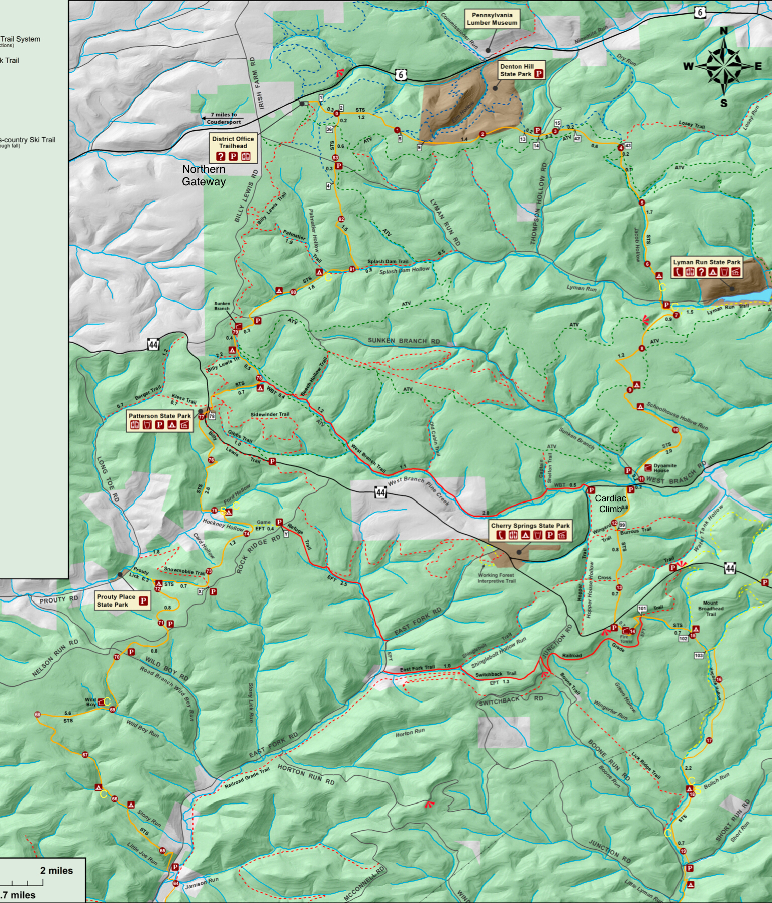
 For the maps above, C are established campsites I saw. S are new shelters not shown on the map. Note that not all the camping symbols on the map are established sites.
View this post on InstagramA post shared by Jeff Mitchell-Outdoors Author (@hiking_mitch)
View this post on InstagramA post shared by Jeff Mitchell-Outdoors Author (@hiking_mitch)
View this post on InstagramA post shared by Jeff Mitchell-Outdoors Author (@hiking_mitch)
View this post on InstagramA post shared by Jeff Mitchell-Outdoors Author (@hiking_mitch)
View this post on InstagramA post shared by Jeff Mitchell-Outdoors Author (@hiking_mitch)
View this post on InstagramA post shared by Jeff Mitchell-Outdoors Author (@hiking_mitch)
View this post on InstagramA post shared by Jeff Mitchell-Outdoors Author (@hiking_mitch)
View this post on InstagramA post shared by Jeff Mitchell-Outdoors Author (@hiking_mitch)
View this post on InstagramA post shared by Jeff Mitchell-Outdoors Author (@hiking_mitch)
View this post on InstagramA post shared by Jeff Mitchell-Outdoors Author (@hiking_mitch)
View this post on InstagramA post shared by Jeff Mitchell-Outdoors Author (@hiking_mitch)
View this post on InstagramA post shared by Jeff Mitchell-Outdoors Author (@hiking_mitch)
View this post on InstagramA post shared by Jeff Mitchell-Outdoors Author (@hiking_mitch)
View this post on InstagramA post shared by Jeff Mitchell-Outdoors Author (@hiking_mitch)
October 4, 2023
Hike the Beech Lake/ Six Ponds Loop- SGL 57
 A pond in SGL 57
Length: Loop is 4-5 miles. Optional side hike to the views is a total of 6-7 miles.
Difficulty: Moderate. Terrain is level and hilly in places.
Highlights: Isolation, several ponds, Beech Lake, wildlife, birds, wildflowers, views, meadows.
Parking: pull off lot at 41.359602, -76.235280.
Issues: No trails have blazes or signs, but are generally well established. It can be tricky to see where a trail leaves a road. Navigation can be an issue for inexperienced hikers. This hike has no bushwhacking, it is all on trails or forest roads. The roads have sun exposure in hot weather. Wear orange in hunting season.
Description: A version of this loop is described in Hiking the Endless Mountains. It is a fairly easy walk and ideal for birdwatchers and those who love wildlife. I’ve also heard this area has an incredible diversity of dragonflies and damselflies. The highlights are all the ponds along this hike, with Beech Lake being the most beautiful.
From the parking area, walk to the right on the road (if facing the parking area from the road) and cross a creek. Turn left onto Beech Lake Road and then veer left onto an obvious, unblazed trail. The trail splits as you near the lake, take the left and cross a creek. See the end of Beech Lake. Follow a trail to the left, leaving the lake.
Hike through scenic forests with ferns. The trail follows an old grade. Reach a gravel forest road, turn right. Follow the road up a gradual hill, there has been logging in the forests. The road turns right and descends. Notice an old forest road to the right. Take it to see one of the ponds, return to the gravel forest road.
Reach a T intersection, if you want to see another pond, go left and turn left on a grassy forest road that goes down to a very scenic pond. Otherwise, turn right and soon another pond comes into view. An old forest road goes to that one as well. The views are beautiful.
The road enters the woods with views over a pond to the left. Cross a small stream and keep an eye out for a trail to the right. Take it. Reach a gorgeous view of Beech Lake, a highlight of this hike. The trail climbs away from the lake and then returns with excellent views from the other end of the lake. Complete the loop and return back to your car.
While here, you can also follow a trail to some great views from cliffs. I did not go there on this hike. It is part of the White Gold Loop.
 Grey is gravel roads or old forest roads. Brown is trails. No trails are blazed. This map is for general directional purposes only and is not a GPS route.
 More photos:
View this post on InstagramA post shared by Jeff Mitchell-Outdoors Author (@hiking_mitch)
View this post on InstagramA post shared by Jeff Mitchell-Outdoors Author (@hiking_mitch)
Hike the Elklick Run Wilderness-Mokoma Conservancy

Length: About 2.5 – 3 miles
Blazes: All trails are blazed white
Parking: gravel lot at about 41.419029, -76.480846.
Difficulty: Easy to moderate. Terrain is hilly.
Highlights: Scenic woodlands, field, small streams and meadows. Easier access to Mokoma Falls (off trail).
Issues: While well blazed, not all trail junctures have signs. Some wet areas.
Description: Elklick Run Wilderness is a new preserve owed by the Mokoma Conservancy, it is located near the Conklin Run Wilderness preserve. Elklick features a white blazed trail system with easy to moderate terrain. From the parking area, follow an access trail to the start of the loop and turn left. We hiked the entire loop. The trail was well blazed and easy to follow. There are two link trail across the loop, not one as indicated on the map.
The terrain is level and rolling, with small climbs and descents. This is a forest hike with a field, small fern meadows, some hemlocks, and small streams. It is a pleasant walk. You can easily hike here and the nearby Conklin Run Wilderness.
Complete the loop and retrace your steps back to the parking lot.
One advantage of this preserve is the much closer access to Mokoma Falls, which is a short distance downstream on Elklick Run, in SGL 13. This is an off trail hike. I described a hike to Mokoma Falls before from Conklin Run.
 Map provided by the Mokoma Conservancy
More photos:
View this post on InstagramA post shared by Jeff Mitchell-Outdoors Author (@hiking_mitch)
September 25, 2023
Beers Community Wetland Nature Trail-Wysox, PA

Length: Quarter mile loop
Difficulty: Easy
Parking: lot located at 41.778186, -76.400751.
Highlights: Boardwalks, wetlands, diverse plant life. Great hike for small kids.
Description: This is a short, easy trail that explores wetlands. Wetlands are crucial ecosystems and hikes exploring them are rare. From the kiosk, follow the boardwalks across the wetlands, which harbor diverse plant and animal life. A total of 119 species of plants have been identified along the trail. Enjoy wildflowers from spring to fall, and colors in the fall.
Reach dry land and the trail is mowed. There are many informational signs discussing wetlands and their importance. Begin hiking a second boardwalk and reach a lawn behind some ballfields. Turn left and walk behind the ballfields back to the parking lot.

View this post on InstagramA post shared by Jeff Mitchell-Outdoors Author (@hiking_mitch)
Hike to Wildcat Falls-Back Mountain Trail
 Wildcat Falls
Length: Approx. 1.5 miles, one way
Difficulty: Easy. The unblazed trail up along the falls is steeper and more rugged.
Parking: 41.302392, -75.927850. Park near a fire station and district court, do not park in assigned spaces.
Highlights: Waterfalls, views, wildflowers, historic remnants along the Back Mountain Trail
Description: This is an easy hike to beautiful Wildcat Falls. This hike follows the Back Mountain Trail, an unblazed rail trail that is easy to follow. The terrain is nearly level. Expect noise from the nearby highway.
From the parking area, climb the steps to the trail and follow it. There are some benches and old metal tanks that are rusting, likely used when the trains used the trail you are now walking. As you hike, the views open up and there are wildflowers. The views aren’t spectacular as they simply look across the highway, but they are nice nonetheless. Reach a footbridge and look up to your left to see Wildcat Falls. The falls plummet over a series of cascades and ledges. There are large boulders. The falls are very scenic, but they are best seen after a good rain since the creek is small. In summer, the falls are often dry.
To see more of the falls, follow an unblazed trail on the west side of the creek. Enjoy the scenery. This trail is steeper and more rugged. There are many cascades. I stopped at a powerline swath, but I believe there are more bedrock slides above.
Return the way you came. This is a great, short waterfall hike. It is surprising how much beauty surrounds Wilkes Barre and Scranton.
 Back Mountain Trail
 Green is the Back Mountain Trail. It has signs but no blazes, it is easy to follow. Brown is the unblazed trail along Wildcat Falls, it is more rugged and steeper.
More photos and video:
View this post on InstagramA post shared by Jeff Mitchell-Outdoors Author (@hiking_mitch)
View this post on InstagramA post shared by Jeff Mitchell-Outdoors Author (@hiking_mitch)
View this post on InstagramA post shared by Jeff Mitchell-Outdoors Author (@hiking_mitch)
View this post on InstagramA post shared by Jeff Mitchell-Outdoors Author (@hiking_mitch)
July 16, 2023
Hike to Wolf Swamp Run Falls and Deep Lake-SGL 38
 Deep Lake
Length: Approx. 4.5 mile loop
Difficulty: Easy to moderate. Buswhack is steep.
Parking: 41.044702, -75.372675
Issues: You must be comfortable navigating and hiking unblazed trails. Bushwhack required to see the waterfalls, it is short and steep.
Highlights: Waterfalls, lakes, blueberries, azaleas and mountain laurel.
Description: This is a great loop to hike in the Poconos, located next to Big Pocono State Park. It features waterfalls and scenic lakes. The terrain is also forgiving. SGL 38 has a wide network of unblazed trails, typically used by mountain bikers. Since there are no blazes or signs, you must be comfortable navigating in this type of environment.
From the parking area, walk around the gate and reach a powerline swath. Turn right on the swath and hike down it a short distance. Keep an eye for a trail that goes into the woods to the left, follow it. This trail meanders through the forest with ferns and blueberries. The forest is mostly hardwoods. Reach Wolf Swamp Run. There is a seven foot falls below the trail and bedrock slide above it. Cross the run. If you want to see Wolf Swamp Run Falls, you must go off trail. It is best to hike on the north slope of the run, the brush isn’t too thick. Go down to the falls; the slope is steep. There are four drops that might be 40 feet high in total. The last drop is probably the most scenic, less than fifteen feet, but has a grotto of cliffs and rhododendron.
Back on the trail, hike from the creek and turn left onto a trail. Continue straight at the next intersection. Reach a forest road and turn left. The road goes near Deep Lake and you can hike down to the water. This lake is very beautiful, surrounded by meadows of blueberries with azaleas and mountain laurel. It must be amazing in the fall. We saw white and pink azaleas blooming.
Continue on the forest or jeep road. Turn left at the intersection. Pass beautiful Wolf Swamp Lake as it stretches into the forest. Climb a hill, veer left, and then continue straight on the road. Reach the end of the loop at the powerline and return to your car.
I look forward to exploring more of the trails at SGL 38. There are more lakes I’d like to see and I’m sure the fall colors are amazing here with the blueberry meadows.
PA Is beautiful. Explore it.
 This map is for general directional purposes only and is not a GPS route. Red is off trail. Black are forest or jeep roads. Brown is established, unblazed trails. There are no signs or blazes.
 Wolf Swamp Run Falls, bottom falls
 Wolf Swamp Run Falls
More photos:
View this post on InstagramA post shared by Jeff Mitchell-Outdoors Author (@hiking_mitch)
View this post on InstagramA post shared by Jeff Mitchell-Outdoors Author (@hiking_mitch)
View this post on InstagramA post shared by Jeff Mitchell-Outdoors Author (@hiking_mitch)
July 14, 2023
Explore the Chasms of Rock Run-Loyalsock State Forest
 Chasm of Rock Run
Length: About 4.5 – 5 miles
Parking: 41.534971, -76.891889
Highlights: Waterfalls, pools, cascades, gorges, grottos, chasms, campsites.
Trail conditions: Variable. The Old Loggers Path (OLP) is well established and blazed. This hike also involves off trail hiking, creek walking, and following a forest road.
Issues: do not do this hike in high water, Rock Run becomes a deadly whitewater river.
Description: Rock Run has long been a popular destination in the Loyalsock State Forest. It is famous for its beauty with cascades, falls, and bedrock pools. Almost the entire creek has this type of scenery. Rock Run is one of the most beautiful creeks I have ever seen.
This hike is also described in Hiking the Endless Mountains.
This hike explores the upper part of Rock Run, which is much less popular. It is still very beautiful. This hike requires some navigational experience. There are many route options, and part of this hike follows the creek itself. From the parking area, cross the bridge over Rock Run and turn right on Pioneer Road, a gated forest or jeep road. Follow it to a hunting cabin. This is Hawk Run. If you want to see the gorges and cascades on Hawk Run, go up the creek. There may be a faint path. Come to some slides with a huge cliff and giant boulders. Return the way you came.
From Hawk Run, we simply creek walked up Rock Run, but you can choose to also take Pioneer Road. The creek walk is much more scenic with several cascades, pools, and grottos. Either way, you will come to the first chasm, just downstream where the North Branch of Rock Run joins Rock Run. This chasm is stunning with towering cliff walls, slides, deep pools, and cascades. Just upstream is the second chasm, with a large pool, cascade, and huge ledges. This spot is truly spectacular.
Again, you can hike out via Pioneer Road, but we did a short bushwhack up the hill to the OLP and hiked it down to Yellow Dog Run. This is another incredible spot with more deep, bedrock pools, and the famous falls of Yellow Dog Run. From here, we left the OLP and simply followed Rock Run downstream. There was an unblazed path in many places. We occasionally walked along the creek. Rock Run continued to impress with its scenery. We hiked under cliffs, through grottos and along cascades. The unblazed path became more defined and we soon reached our cars at Yellow Dog Road.
PA is so beautiful. Explore it.
 This map is for general directional purposes only and is not a GPS route. Red is off trail. Brown is an old logging or jeep road. Yellow is an intermittent unblazed path. You cannot drive up Pioneer Road.
 Yellow Dog Run meets Rock Run
 Chasm of Rock Run
More photos and videos:
View this post on InstagramA post shared by Jeff Mitchell-Outdoors Author (@hiking_mitch)
View this post on InstagramA post shared by Jeff Mitchell-Outdoors Author (@hiking_mitch)
View this post on InstagramA post shared by Jeff Mitchell-Outdoors Author (@hiking_mitch)
View this post on InstagramA post shared by Jeff Mitchell-Outdoors Author (@hiking_mitch)
View this post on InstagramA post shared by Jeff Mitchell-Outdoors Author (@hiking_mitch)
View this post on InstagramA post shared by Jeff Mitchell-Outdoors Author (@hiking_mitch)
July 9, 2023
Explore Sones Rocks-Loyalsock State Forest
 Sones Rocks
Length: About 3 miles.
Trail conditions: The Loyalsock Trail (LT) is well blazed and established. Remainder of the hike is off trail, or follows an unblazed trail.
Difficulty: Moderate. Due to navigation, only experienced hikers should attempt.
Highlights: Rock formations, giant boulders, rock shelter, Sones Pond, hemlock forests
Parking: 41.471696, -76.514545
Description: This hike explores impressive cliffs and rock outcrops just off the LT. It would be nice of the LT was rerouted to include these features. From the parking area, follow an unblazed trail on the east shore of Sones Pond as it tunnels into the brush. Enter an open hemlock forest and reach the LT, proceed left, or straight on the LT. Enjoy views of the pond and beautiful hemlocks. Before reaching Rock Run, you’ll want to go off trail to explore the West Escarpment of the rocks. At first, the rocks aren’t very big. As you head north, the rocks grow in size, featuring some passageways and small mazes. Hemlocks grow above and there is a lot of moss. The cliffs tower to about 40 or 50 feet in places. It is a fascinating place to explore with many nooks and crannies.
The west escarpment can be found about here: 41.479015, -76.518955.
The east escarpment is not as impressive. There are some ledges. However, there is a large rock shelter that you should not miss. It might be 50-60 feet wide and 20 feet deep. Below both the east and west escarpments are old forest roads you can use to navigate and explore.
 This map is for general directional purposes only, it is not a GPS route. Red is off trail.
 Sones Rocks
 Sones Rocks
 Rock shelter on east escarpment
More photos and video:
View this post on InstagramA post shared by Jeff Mitchell-Outdoors Author (@hiking_mitch)
View this post on InstagramA post shared by Jeff Mitchell-Outdoors Author (@hiking_mitch)
View this post on InstagramA post shared by Jeff Mitchell-Outdoors Author (@hiking_mitch)
Hike to Doe Run Falls-Loyalsock State Forest
 Doe Run Falls
Length: less than one mile, one way.
Highlights: Rugged gorge, large boulders, cascades, Doe Run Falls
Parking: 41.534967, -76.891884
Trail conditions: This hike follows a gated road, a faint trail, and then goes off trail. No trails are marked or blazed.
Difficulty: Easy to difficult
Description: This short hike goes to another of the Loyalsock State Forest’s waterfalls. This hike gets pretty rugged as you near the falls. From the parking area on Yellow Dog Road, hike up the road a short distance and turn right onto a gated road. This road goes to a cabin. Walk behind the cabin and meet Doe Run. Doe Run can be dry in summer or times with little rain. Turn left and hike up the creek, keeping to the east of it. You may notice a faint path. Below you there are cascades and large boulders in Doe Run.
You will have to cross the creek. The rest of the hike is off trail and is rugged. There are many large boulders, pools, and cascades. Pick your way up as best you can. You will soon reach Doe Run Falls, no more than fifteen feet tall in a beautiful grotto of cliffs. Above is a narrow chasm with more slides and cascades. If you count the chasm and cascades above, the falls might be 30 or 40 feet in total height. The chasm is very scenic. This description does not go to the chasm; it is a steep climb. Enjoy this beautiful spot.
You can also reach the falls by hiking off trail down from the Old Loggers Path.
When you are finished, simply retrace your steps back to the car.
 This map is for general directional purposes only, it is not a GPS route.

More photos:
View this post on InstagramA post shared by Jeff Mitchell-Outdoors Author (@hiking_mitch)
View this post on InstagramA post shared by Jeff Mitchell-Outdoors Author (@hiking_mitch)
Jeff Mitchell's Blog

- Jeff Mitchell's profile
- 3 followers

