Jeff Mitchell's Blog, page 6
April 12, 2024
Hike to Pine Island Ledge Vista and Waterfalls-Pine Creek Gorge (PA Grand Canyon)
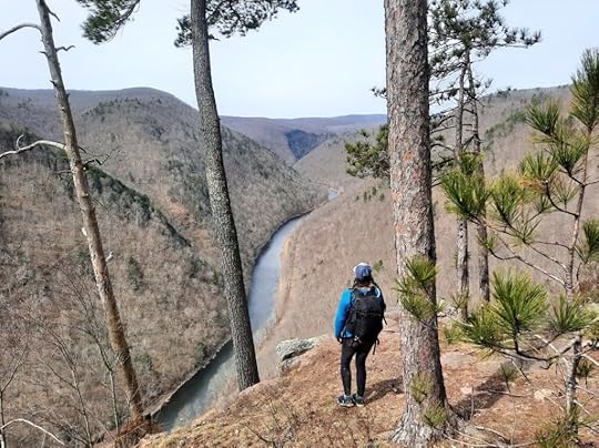 Pine Island Ledge Vista
Length: Approx. 8 miles
Difficulty: Very difficult and challenging.
Trail conditions: Route follows unmarked and unblazed trails, old forest roads or grades, and off trail hiking. It is a steep climb or descent to/from Pine Island Ledge. The bottom section of Pine Island Run requires scrambling along waterfalls and traversing a landslide. It is the most challenging part and potentially dangerous. Do not attempt in high water.
Highlights: Incredible views, cliffs, rock outcrops, glens, many waterfalls and cascades.
Parking: 41.631387, -77.395402. Drive in from the north. There is no bridge where Claymine Road crosses Stony Fork.
Peregrine falcons: They nest at Pine Island Ledge. I was not aware they were nesting when I visited. Consider hiking elsewhere until their nesting season is over.
Rattlesnakes: Can be found at the vistas, and along the hike.
Cliffs: This hike goes near massive cliffs. Be careful. Any fall would be fatal.
Other navigation aids: Look at MyHikes for Pine Island Run and Ledge. You might want to hike them separate to avoid the lower section of Pine Island Run. Also, a prior post to the ledge.
Description: Pine Island Ledge is widely considered the most beautiful view in the Pine Creek Gorge, if not Pennsylvania. I think it is one of the most beautiful canyon or gorge views in the eastern U.S. Here, the canyon is so narrow and Pine Creek flows hundreds of feet below. The ledge has become an increasingly popular destination in the Tioga State Forest.
This is a very challenging hike, only experienced hikers should attempt. It is one of the most beautiful, and difficult, hikes in the Pine Creek Gorge. Most hikers to Pine Island use the rail trail, but this way is long and taxing. The hike from Claymine Road is much more scenic and challenging.
Hiking the loop clockwise or counterclockwise has its benefits. Clockwise requires a difficult scramble down Pine Island Run and a steep climb up to Pine Island Ledge. Counterclockwise is the opposite. It may be best to scramble up the lower gorge of Pine Island Run, which I consider the most challenging part. You can always skip this part and just go to the view.
From the parking area, follow an obvious trail through laurel down to Pine Island Run. Reach an intersection (see picture below). Go left to hike clockwise, right is counterclockwise. We hiked clockwise.
The hike along Pine Island Run is very beautiful with many cascades and slides. You will have to hike off trail much of the way and cross where you need to. The bottom of this gorge is very beautiful but challenging. It is best to stay on the west side of the creek. Be careful crossing a landslide. Rocks and cliffs tower above. Never attempt this hike in high water as the lower part of the gorge becomes too dangerous.
An unmarked trail makes the steep climb to the view. The view is simply incredible, framed by pine trees. An obvious trail continues north from the view, it becomes an old atv trail. There is one more view. There are beautiful pine and hemlock forests. The trail reaches private property, here go off trail to the east, roughly following the state forest boundary markers. Descend to an old grade This grade will take you to a campsite. Cross the creek and complete the loop.
You should have navigational aids or apps to hike this trail, especially the off trail part at the north end of the loop. The rest is fairly easy to navigate.
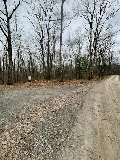 Parking on Claymine Road. Trail begins behind white sign.
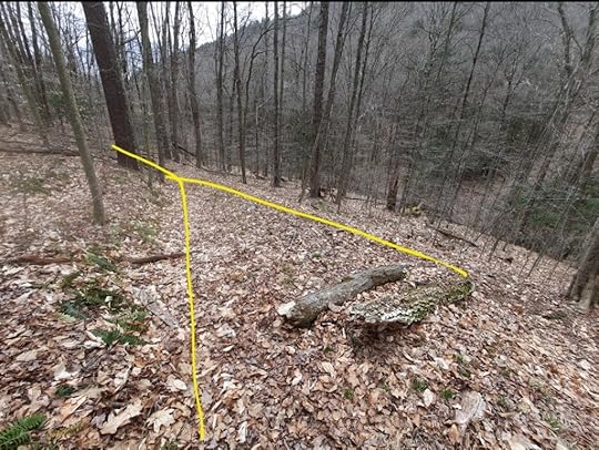 This is where the trail from the parking area meets the loop. Left is down Pine Island Run, clockwise. Right is counterclockwise.
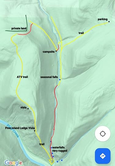 Red is off trail. Yellow are unmarked trails or old logging grades, some can be faint. Blue dots are waterfalls or cascades. This is not a gps track, accuracy not guaranteed, it is for general directional purposes only. Hike at your own risk. This is a very difficult hike with potentially dangerous sections.
 View this post on InstagramA post shared by Jeff Mitchell-Outdoors Author (@hiking_mitch)
View this post on InstagramA post shared by Jeff Mitchell-Outdoors Author (@hiking_mitch)
View this post on InstagramA post shared by Jeff Mitchell-Outdoors Author (@hiking_mitch)
View this post on InstagramA post shared by Jeff Mitchell-Outdoors Author (@hiking_mitch)
View this post on InstagramA post shared by Jeff Mitchell-Outdoors Author (@hiking_mitch)
View this post on InstagramA post shared by Jeff Mitchell-Outdoors Author (@hiking_mitch)
April 8, 2024
Hike to Rosecrans and McElhattan Falls
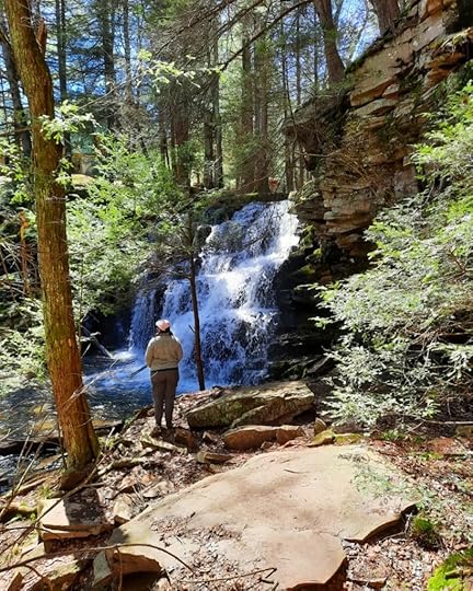 Rosecrans Falls
Length: less than a mile one way
Trail conditions: trail to the falls is unmarked but easy to follow. It is a little steep down to the falls. Unmarked trails go down the gorge. Off trail to side stream falls and cove.
Parking: pull off parking at 41.074207,-77.328522. Don’t block the gates.
Highlights: beautiful double waterfall and an impressive gorge.
Description: This short hike leads to a beautiful double falls and a gorge enveloped in cliffs. This place is significant, with the largest falls in PA’s ridge and valley region, and one of the largest falls in the PA Wilds outside of Pine Creek.
To find the trail, walk north on Nittany Ridge Road and cross a small creek. Look for an unmarked trail to the right, follow it along the creek. It’s beautiful with hemlock forests. Reach the crest of Rosecrans Falls. Across the creek is private property and a home, do not trespass.
To get to the bottom of the falls, I actually recommend following the trail slightly uphill above ledges. The trail will then curve down below the ledges to the falls. This is more gradual with less erosion. You can scramble down a shortcut, but it is eroded.
The setting is truly beautiful. Enjoy the two falls and towering cliffs. McElhattan Falls may be on private land so don’t venture over there.
To see more, follow unmarked trails down along the creek. Cliffs tower on the other side, complete with a trickling falls 40 feet tall. It must be impressive when frozen. Cross the creek and go off trail into a side cove with a 10 foot falls surrounded by cliffs, another beautiful spot. I was as impressed by the cliffs and gorge as the falls.
Retrace your steps.
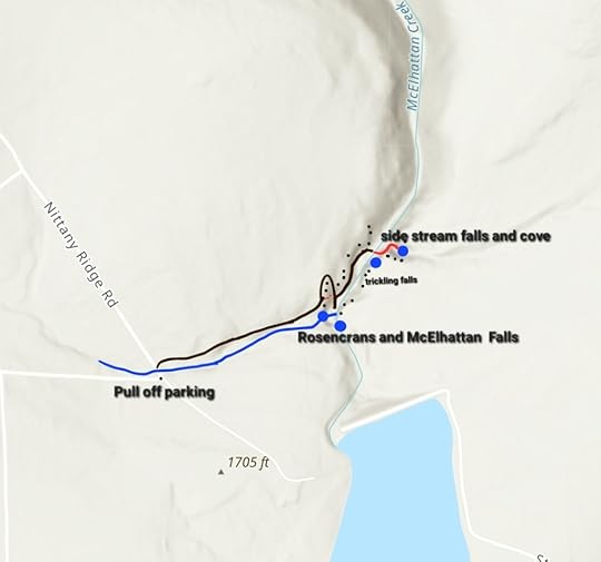 Brown are unmarked trails. Red dots are eroded and steep scramble that should be avoided. Solid red is off trail. Black dots are cliffs. Trails are not blazed. Excuse the typo, it is Rosecrans, not Rosencrans. This is not a GPS track, it is for general directional purposes, accuracy not guaranteed, hike at your own risk.
View this post on InstagramA post shared by Jeff Mitchell-Outdoors Author (@hiking_mitch)
View this post on InstagramA post shared by Jeff Mitchell-Outdoors Author (@hiking_mitch)
View this post on InstagramA post shared by Jeff Mitchell-Outdoors Author (@hiking_mitch)
April 1, 2024
Hike to the Tioga Lake Ledges-State Game Lands 37
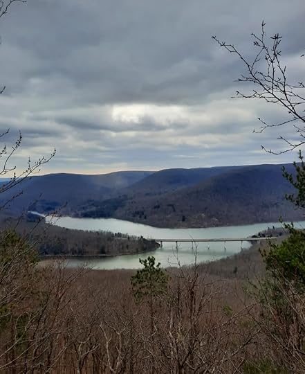 View from Tioga Lake Ledges
Length: Varies depending on route taken, but you can expect to hike around 4 miles.
Parking: 41.880412, -77.114154.
Difficulty: This is a challenging hike, off trail, with steep slopes.
Trail conditions: This is an off trail hike that follows the creeks and climbs into the woods. Forests are open.
Terrain: Hiking up to the ledges involve steep slopes, but there is no scrambling or rock climbing. Slopes can have loose dirt and rocks.
Highlights: Great views, seasonal falls and cascades.
Alternative access: Access may be possible from Park Hill Road which can avoid the climbing, but I did not go that way.
Description: This hike is notable for having a lake view with mountains, a rarity in PA. This is a rugged, off trail hike. This hike is located on SGL 37 and Army Corps of Engineer lands, which is leased to the Mill Cove Environmental Area. The area is open to the public, but there was a gate at the access. The gate was open when I visited.
From the parking spot, which is nothing more than a turn around at the end of the road, hike back down the road and turn left up the road to the shooting range. If the range is being used, do not access the hike this way (obviously). Walk to the back corner of the range and see an unblazed trail, follow it. The trail follows an old grade in hemlocks above Phoenix Run. There are slides and cascades below. Leave the grade and hike off trail up a tributary. Phoenix Falls comes into view. It is a seasonal falls, but a beautiful sight when flowing well. It is about 15 feet tall.
Here I simply turned and hiked up the slope. It was a steady climb with ledges. At the top, I followed the plateau west to the Tioga Lake Ledges, located at 41.889626, -77.118697. The ledges offer great views of the lake below, including the bridge. It is beautiful. From here, I went down the slope to the south and angled east back to Phoenix Run, retracing my steps to the shooting range and my car.
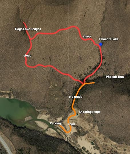 This map is not a gps track, it is for general directional purposes only, accuracy not guaranteed. Your route may vary. Red is off trail. Orange is on roads, or old forest grade/road.
 View this post on InstagramA post shared by Jeff Mitchell-Outdoors Author (@hiking_mitch)
View this post on InstagramA post shared by Jeff Mitchell-Outdoors Author (@hiking_mitch)
March 27, 2024
Tent Review: 3F UL Lanshan 1 Pro
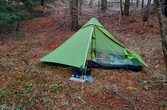 My Lanshan 1 Pro
The Lanshan 1 Pro is probably the best buy among one-person trekking pole tents. It is light, well made, and a fraction of the price of other tents. If you are looking to lighten your kit, but don’t want to spend $600 on a tent, take a look at the Lanshan 1 Pro, which is around $140. Here is my review:
More information: Click here for manufacturer’s website with specs, price, and other info.
Unbiased: I paid for my tent and did not receive any incentives for this review.
Experience with this tent: I’ve backpacked over 100 miles with this tent.
Other tents I’ve used: various Eureka backpacking tents, Zpacks Duplex.
Quality of construction: I found it well made with quality stitching, zippers, mesh, and materials. Guyline attachments are reinforced with UHMWPE patches. Guylines are reflective and the door guyline has a glow in the dark clasp. The fly is waterproof to 2000mm hydrostatic head. The bathtub floor to 6000mm. For comparison, the Gossamer Gear The One tent is waterproof to 1800mm. The tent comes with stakes and additional guylines. I found the stakes sufficient, but some hikers might want longer ones.
Weight: My tent is 1 pound, 10 ounces without stakes.
Packed size: Incredibly small. See photo below.
Room inside: I found it quite roomy for a one person tent. I did not feel like I was in a coffin. There was plenty of space for my bag and other gear. They fly was not in my face while sleeping (I’m 6 feet tall). There was more than enough to room to change clothes. The fly is plenty large to keep items outside out of the rain.
Weatherproof: I have not used it in heavy rain, only light showers. It was fine. I did douse it with my garden hose and it performed great (You do need to seam seal this tent, which took me 45 minutes and was easy to do). It handled the wind great.
Condensation: I camped along streams with half of the fly open, condensation was minimal. I’m sure it will collect condensation on muggy nights. Condensation was the same or better than a far more expensive DCF tent I’ve used. There is wrap around mesh above the bathtub floor for airflow.
Ease to set up: Once you get used to it, it’s easy, like any trekking pole tent. I stake the corners out, put in my pole and stake out that guyline, and then stake out of opposite guyline. The bottom corners of the tent have their own guylines, which I often don’t use.
Things to improve: I wish the bathtub floor was a little deeper. The peak vent doesn’t let a lot of air in. Again, you need to seal the seams or pay extra for the manufacturer to do it for you. I did it myself, it was easy.
Would I recommend? Absolutely. I don’t think you can find a better tent for the quality and price. Lots of online reviews categorized this tent as “budget” or “cheap.” Don’t be fooled. It is a quality, well-made tent. It is the ideal shelter for those looking to transition to lightweight hiking while saving money.
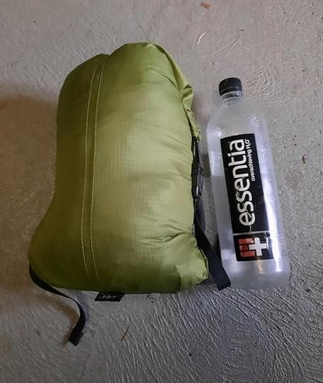 The Lanshan 1 Pro packs down very small.
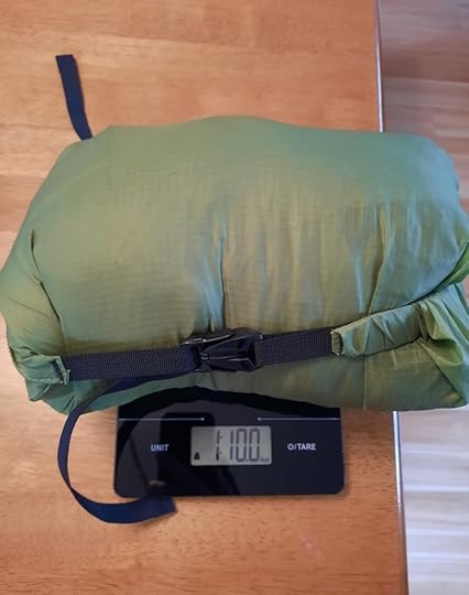 My tent weights 1 pound, 10 ounces with stuff sack, and seam sealed. Stakes are not included in this weight.
March 18, 2024
Hike to the Corridors (Scranton Rock Maze)-Pinchot State Forest
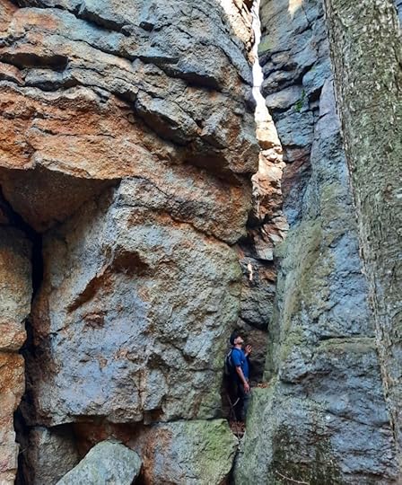 In the Corridors, an impressive place for rock lovers.
Length: About 2.5 miles, one way.
Parking: Salvation Army parking lot, 41.392955, -75.650236. Obviously this is private property, if parking is not allowed here, park on a side street.
Trail conditions: Hike follows an obvious old rail bed. Hike to the rocks is off trail and can be challenging. Be careful exploring the rocks.
Highlights: Impressive cliffs, boulders, and rock outcrops. Views. Bedrock balds and meadows. Ice flows in winter.
Issues: Route is not blazed and this hike is in an urban setting next to I-81. ATVs use the rail bed.
Description: It’s surprising how much beauty exists in and around Scranton, and these rocks are just another example of that. This hike is on the ever-expanding Pinchot State Forest, which has now reached into Scranton. This land was acquired in 2023.
I don’t know if the rocks have a name. I heard them described as corridors, I also heard them called trenches.
From the parking lot, cross River Street and around the concrete barriers on the old rail bed. Follow it. Pass a seasonal falls off to your left. Rocks begin to rise, as well as an impressive old retaining wall built with giant stones. There are some views from the rail bed, and wetlands are below to the right. Even in an urban area, there are important habitats.
After about 1.5 miles, leave the rail bed at the yellow dot on the map. You will know you reached the spot when the steep slope eases and old eroded trails ascend to the left. Climb here. The rocks soon come into view. Have fun exploring them. These rocks have springs trickling over them, making this a great place to see ice flows in winter. Work your way south exploring the mazes and passageways. Reach the Corridors, a series of giant outcrops with maze like passes. It’s an impressive place. Be careful. After the Corridors, the rocks decrease in size, but are still impressive. This would be an incredible place for rock climbing and bouldering.
We scrambled to the top where there are some views, pitch pine, bedrock balds and greenbrier. I was told there are many snakes here in the summer.
After exploring the rocks, return to the rail bed and hike out.
Want more scenery? Nearby is the impressive Montage Glen. After hiking, visit one of Scranton’s restaurants or breweries (or buy something from the Salvation Army).
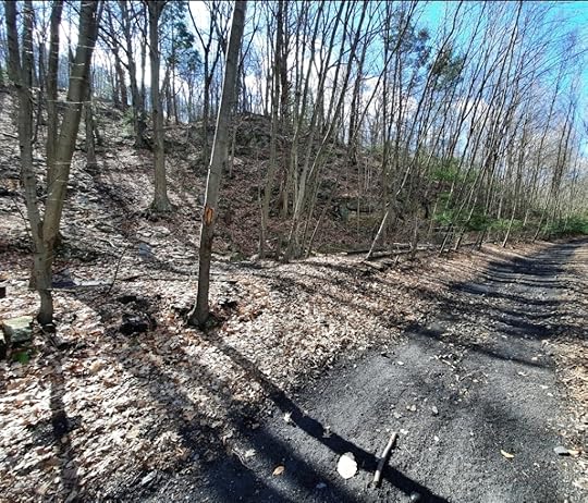 This is the yellow dot on the map. Turn left and climb up the slope on an eroded trail to the rocks. Exploring the rocks is off trail.
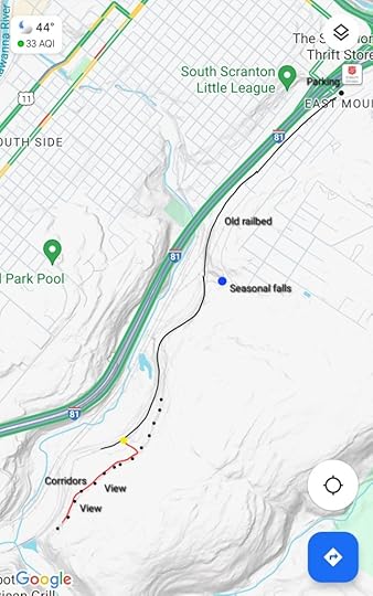 Red is off trail. Black dots are the rocks. This is not a gps track, accuracy is not guaranteed, and is for general directional purposes.
View this post on InstagramA post shared by Jeff Mitchell-Outdoors Author (@hiking_mitch)
View this post on InstagramA post shared by Jeff Mitchell-Outdoors Author (@hiking_mitch)
View this post on InstagramA post shared by Jeff Mitchell-Outdoors Author (@hiking_mitch)
View this post on InstagramA post shared by Jeff Mitchell-Outdoors Author (@hiking_mitch)
March 13, 2024
Long Distance Backpacking: Should You Get a One or Two Trekking Pole Tent?
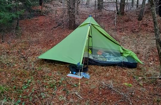 My 3F UL Lanshan 1 Pro tent, a one pole tent, on the Quehanna Trail. I backpacked over 100 miles with it.
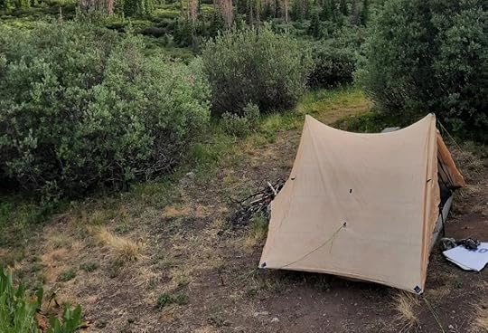 My friend’s Zpack’s Duplex tent, a two pole tent. I thruhiked the Colorado Trail with it.
Despite backpacking for decades, I didn’t buy a trekking pole tent until 2023. Until then, I used trusty, cheaper, and heavier Eureka tents. (Shout out to the Gossamer, Backcountry 2, and finally the Spitfire, which did a great job on my AT thruhike).
It’s little wonder why trekking pole tents have become increasingly popular. They are light and utilize something many hikers already carry, trekking poles, for structure. Efficiency and gear that can serve more than one purpose is the name of the lightweight game.
Trekking pole tents come in two basic flavors, those that use one pole, and those that use two.
I’ve used both. Here are the reasons why I prefer a one pole tent:
Cheaper.Lighter.Packs down smaller.Tends to be easier to set up.Have a smaller footprint, important when you are dealing with smaller campsites.Basic pyramid design sheds rain more efficiently and handles wind better.Trekking poles break on trail (or can even fail when holding up your tent). Not a problem when you only need one. It is a problem if you use a two pole tent.If you are an ultralight backpacker with a condensed kit and only use one pole while hiking.As a solo backpacker, I don’t need the two vestibules that a two pole tent offers, and the vestibules for one pole tents are usually plenty large enough.Yes, two pole tents offer more space and headroom. Two doors can reduce condensation. Though in my experience, a two pole tent was no better at reducing condensation. However, one pole tents can be surprisingly spacious and their headroom is often sufficient.
Bottom line: if you are a solo long distance backpacker with a fairly lightweight kit, I think a one trekking pole tent is the best option.
Let me know what you think.
March 7, 2024
Hike to the Glen of Cascades-State Game Lands 35
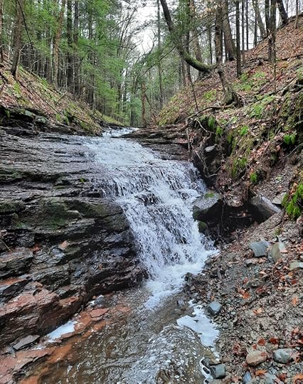 Glen of Cascades
Length: Almost two miles, one way.
Parking: small game commission lot at 41.904172, -75.695533.
Highlights: mature hemlock forests, rock ledges, beaver meadow, Glen of Cascades.
Difficulty: Moderate
Trail conditions: No trails are blazed or marked. The beginning of the trail follows a grassy game commission road. Rest of the hike is off trail but the woods are mostly open.
Description: This is a beautiful hike in an area that receives few hikers, but SGL 35 has hidden wonders waiting to be explored. This hike exceeded my expectations. From the parking lot, follow the grassy road. At a Y (orange dot on the map) turn left and descend on the winding road. The road comes to an end, go off trail in the woods, heading northeast. The woods are mostly open and easy to traverse. Make your way into a mature hemlock forest along a beaver meadow. The forest is beautiful, with large mossy rocks and ledges on the slope. There are some large pines and hemlocks.
Hike along the meadow, enjoying the views. Reach the outlet of the meadow, where a large beaver dam was blown out. Follow the creek downstream. The glen soon comes into view with a series of waterfalls and cascades tumbling over the red rock ledges. None of the falls are very high, but the setting is very scenic and the falls are tallest at the bottom. The hemlocks make the glen that more beautiful. From here, retrace your steps.
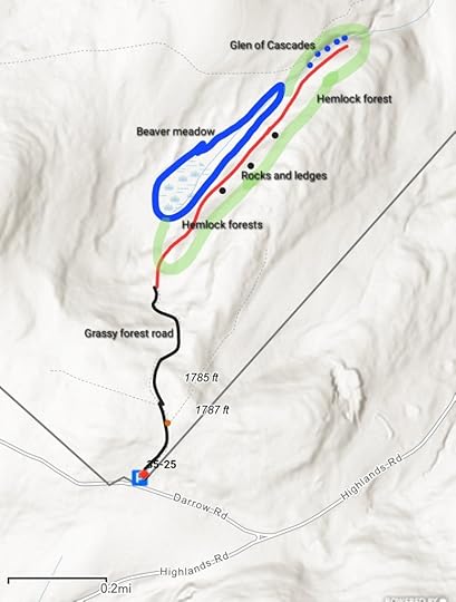 Red is off trail. Turn left at orange dot. This map is not a gps track and is for general directional purposes only.
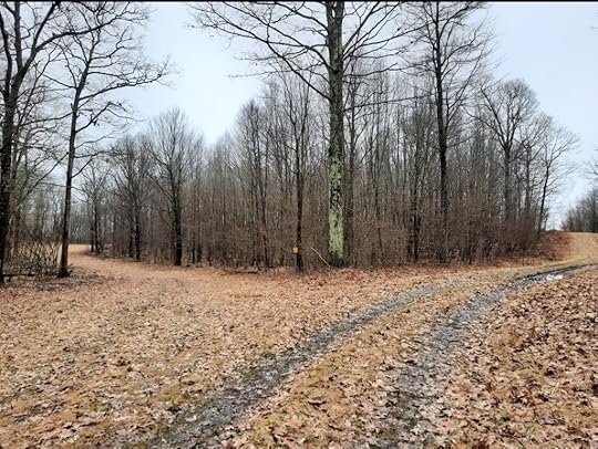 This is where the orange dot is one the map. Turn left here.
View this post on InstagramA post shared by Jeff Mitchell-Outdoors Author (@hiking_mitch)
View this post on InstagramA post shared by Jeff Mitchell-Outdoors Author (@hiking_mitch)
View this post on InstagramA post shared by Jeff Mitchell-Outdoors Author (@hiking_mitch)
View this post on InstagramA post shared by Jeff Mitchell-Outdoors Author (@hiking_mitch)
February 27, 2024
Wykoff/Gore Draft Loop-Quehanna Wild Area
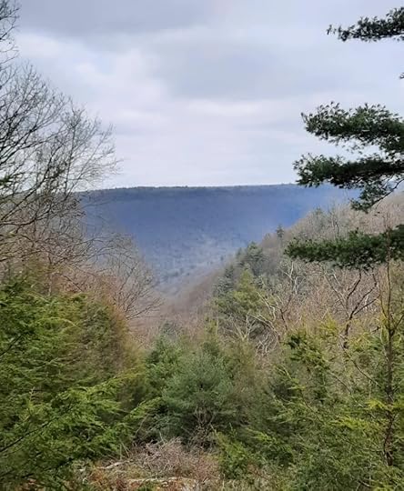 Gore Vista
Length: 11-12 miles approx.
Difficulty: Moderate
Parking: Hoover Farms parking area, 41.229042, -78.191704
Trail conditions: Trails are in decent shape with signs at most junctures. Gore Draft Trail was the most brushy, but can still be followed.
Highlights: Scenic streams, meadows, view, cascades, gorges, old bunker, isolation, lots of hemlock, laurel, and rhododendron.
Description: This is a great loop hike in the Quehanna Wild Area. I was excited to hike this loop since I had not been on some of these trails before. The Quehanna Wild Area is a hiking and backpacking wonderland, and these trails can always use more traffic.
From the Hoover Farm parking area, I crossed the Quehanna Highway and followed a red trail to the yellow Wykoff Trail. I stayed on it as it turned left. The next section to Wykoff Run Road was very scenic with meadows, streams, hemlocks, and camping. I crossed the road and followed the Bailey Log Trail. Here, the trail crossed a vast jungle of mountain laurel (the trail is clear) making this a highlight when the laurel blooms in June.
There is a tricky turn. At the powerline, follow it to the right and veer left onto Gore Loop/Gore Cut off Rd. Turn right onto the Gore Draft Trail. This is the most overgrown trail with hemlocks and rhododendron, but I liked it. The trail is followable. The brush recedes as you enter the gorge with cascades. It is a scenic place. Cross the creek and turn left onto Sevinsky Trail with more cascades, boulders, and hemlocks near the top. This is another beautiful trail.
Turn left onto Foley Trail, another fine trail with hemlocks, meadows, and open hardwoods. The out and back to Gore Vista is worth it, offering a nice “window” view into the Quehanna Wild Area. I then followed Gore Vista Trail to the Gore Cut off Trail where we saw an old blue trail to the left, I hope to explore it someday. I turned right onto Bailey Long, left on Hoover Road, and right onto Old Hoover Trail. This trail was easy and scenic with more hemlocks and laurel. At a meadow, there is an old bunker just off the trail. I reached Quehanna Highway and crossed it to the parking area.
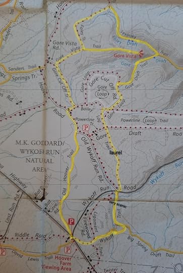 Description above is counterclockwise from Hoover Farm on the highlighted route. Blue are cascades. Orange is an old bunker.
View this post on InstagramA post shared by Jeff Mitchell-Outdoors Author (@hiking_mitch)
View this post on InstagramA post shared by Jeff Mitchell-Outdoors Author (@hiking_mitch)
View this post on InstagramA post shared by Jeff Mitchell-Outdoors Author (@hiking_mitch)
February 13, 2024
Hike the George & Lillian Picton Wildlife Sanctuary-North Branch Land Trust
 View from powerline
Length: our route was a 3.3 mile loop
Difficulty: Easy to moderate. There are hilly climbs, but nothing steep.
Trail conditions: Good. Trails are well blazed and there are signs at junctures.
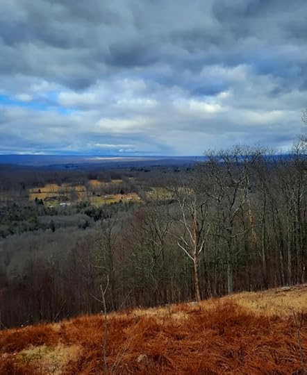
Highlights: Split Rock, pond, view from powerline.
Parking: Entrance is here 41.044088, -75.822334 . Lot is narrow, best to park closer to the road.
Description: This was a surprisingly nice loop hike at a preserve owned by the North Branch Land Trust. From the parking area, walk around the gate and follow the obvious, unblazed road. Where the road turns right, go left on the White Tail Trail, blazed red. The woods are open and climb gradually to a ridge. You can hear traffic from I-80. Reach the top of the ridge and reach a juncture with the Split Rock Trail, blazed yellow. Continue straight on the Split Rock Trail.
Reach a green side trail to a view from a powerline, it’s worth doing and the hike is short. Back on the yellow trail, Split Rock comes into view. It is pretty large and a unique feature. Be sure to see the rock from the back. Follow the yellow trail downhill. At the bottom, follow the blue trail around the pond, another scenic spot. Here, I saw an otter on the ice. The trail is obvious around the pond, but blazes are infrequent. Hike up to some buildings (Main Grounds on the map), turn left on the road, and hike back out.
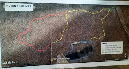 We hiked the loop clockwise on the red, yellow, green, and blue trails.
View this post on InstagramA post shared by Jeff Mitchell-Outdoors Author (@hiking_mitch)
February 4, 2024
Hike to Sawkill and Savantine Falls-Delaware State Forest
 Impressive Sawkill Falls
Length: Approx. 3-4 miles total.
Trail conditions: The Huckleberry Trail was in good shape and easy to follow when I hiked it. It was blazed red, but the blazes were faded and infrequent, much of the trail is unblazed. Expect brushy conditions in summer. Huckleberry Trail is fairly easy with rolling terrain. Off trail hiking required to see the falls and this has more rugged terrain.
Stream crossings: This hike has several stream crossings, all without bridges. Expect wet feet. Do not attempt this hike in high water or at any level where you feel uncomfortable crossing the creeks.
Highlights: Two impressive waterfalls, hemlock forests, long bedrock slide above Savantine Falls, Lily Pond, scenic forests, wetlands.
Parking: There is a lot at Lily Pond. 41.361155, -74.856527
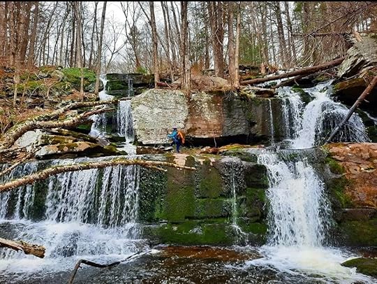
Description: Sawkill and Savantine Falls are two of the Delaware State Forest’s finest falls, yet they are often overlooked. The best way to see them is from the Huckleberry Trail. The much closer way is from Route 6, but that raises issues with parking, crossing and walking along a highway. Take the Huckleberry Trail, it is an easy and scenic trail.
From the pond, see the sign for the Huckleberry Trail and follow it. It’s easy to follow. Expect an impressive red understory of bushes in the fall. The forest is mostly open with hardwoods and pine. Hop across the first stream crossing on rocks, a wetland is nearby. The next stream crossing at Savantine Creek is much larger, expect wet feet here. It too drains a wetland.
The trail climbs gently. Reach the T intersection. Here, an obvious unblazed trail joins from the left. Turn right. Reach an area with stone walls above Sawkill Falls. The trail stays above the creek. To see the falls, simply go off trail down to the creek, cross it above the falls, and scramble down the south side of the falls. Enjoy this stunning falls with its many drops. Go downstream to see impressive Savantine Falls. Above it is a long bedrock slide. This is a strange slide, as the creek barely stays on it, in places it tumbles out of it when there is enough water. Upstream are more cascades and a hemlock forest.
If you don’t want to cross above Sawkill Falls, there is another option. At the T intersection, take the unnamed trail. It is obvious. Pass an abandoned camper and cross Savantine Creek; here the unnamed trail seems to end. Hike off trail downstream along the cascades and long slide in a hemlock forest. Reach Savantine Falls and scramble down. Here, you can hike upstream to Sawkill Falls.
Enjoy this beautiful place.
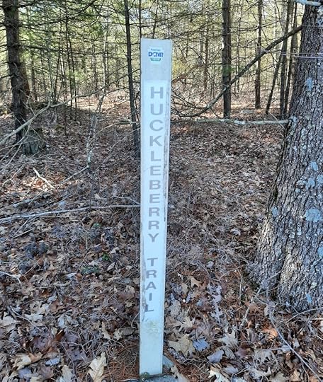 Trail sign near parking area at Lily Pond.
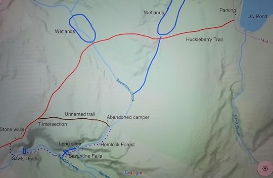 Huckleberry Trail is blazed red, but blazes are faint, infrequent and much of the trail is not blazed. Purple dots are off trail. No stream crossings have bridges. The unnamed trail is well established, but is not blazed. This map is not a GPS route, it is for general directional purposes only and accuracy is not guaranteed.
View this post on InstagramA post shared by Jeff Mitchell-Outdoors Author (@hiking_mitch)
View this post on InstagramA post shared by Jeff Mitchell-Outdoors Author (@hiking_mitch)
View this post on InstagramA post shared by Jeff Mitchell-Outdoors Author (@hiking_mitch)
View this post on InstagramA post shared by Jeff Mitchell-Outdoors Author (@hiking_mitch)
Jeff Mitchell's Blog
- Jeff Mitchell's profile
- 3 followers


