Jeff Mitchell's Blog, page 2
May 21, 2025
Hike the Porcupine Cliffs Loop: Merli-Sarnoksi County Park
Length: About 5 miles
Parking: At the boat launch. 41.589581, -75.537657
Trail conditions: Trails are well established, and most trail junctures have signs. Blazing is infrequent. Must keep an eye out for turns. Trails tend to be curvy. Navigation can be tricky for some hikers, so download the trail map on the Gaia app, using the QR code on the maps in the park.
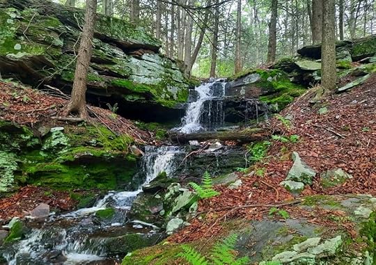
Highlights: Scenic hardwood forests, fern glades, small cascades and waterfalls, rock outcrops and ledges, Porcupine Cliffs, wetlands, views when the leaves are off the trees.
Direction of description: This lollipop loop is described counterclockwise.
Difficulty: Moderate and hilly. The trail is near cliffs and ledges. If you want, you need to go off trail to explore the base of the Porcupine Cliffs and that can be steep.
Description: This loop is a dayhiking gem. I was impressed by its scenery, diversity, and beauty. Merli-Sarnoski is primarily known for its mountain biking, but there are some great hiking opportunities here as well. And this loop is one you should check out.
From the parking area, which is also the boat launch, follow an obvious unblazed trail uphill that goes away from the lake. Veer right at the sign for Twister and reach the glen of a small creek with ledges and small waterfalls. I think this is now the Zipline Trail, and it meanders up through a beautiful hardwood forest with fern glades. Reach a T intersection and go right as the trail levels. Big ledges come into view. Reach the Porcupine Cliffs Trail, go right. Descend to the top of cliffs and ledges, enter hemlocks, and enjoy the rock features. It’s a gorgeous trail. If you want to see the base of the cliffs, you must go off trail and find a break in the cliffs and descend. It is steep. But the cliffs are stunning from below, with towering overhangs. Wow.
Back on the Porcupine Cliffs Trail, it wraps around and joins Twister. (Pro tip: hike the Porcupine Cliffs Trail when the leaves are off the trees, when the sun is setting, it must be incredible). Turn right on Twister as it meanders through scenic woodlands with fern meadows and even vivid green grass meadows. Skirt wetlands and hike along ledges. This is a scenic, fun trail. Enter laurel and hike past the top of the falls you passed earlier. Descend and complete the loop. Turn right to hike back to the car.
Again, the trails are well established, but curvy with various intersections, so the Gaia app is recommended to navigate. While here, you can hike a loop around the lake, it is beautiful. Merli-Sarnoski is just another example of all the beauty that surrounds the Scranton and Wilkes-Barre area.
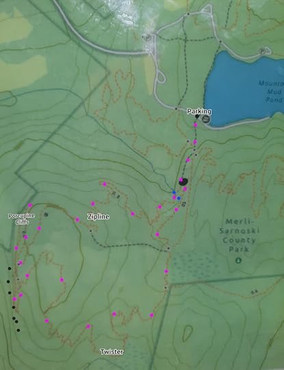 Pinkish dots are my route, trail is not marked that color. Black dots along Porcupine Cliffs Trail are the larger cliffs and ledges. Blue dots are small falls and cascades. Locations are approximate. Base map is from the park.
View this post on InstagramA post shared by Jeff Mitchell-Outdoors Author (@hiking_mitch)
View this post on InstagramA post shared by Jeff Mitchell-Outdoors Author (@hiking_mitch)
View this post on InstagramA post shared by Jeff Mitchell-Outdoors Author (@hiking_mitch)
View this post on InstagramA post shared by Jeff Mitchell-Outdoors Author (@hiking_mitch)
May 17, 2025
Hike to Buttermilk Falls-Bear Creek Preserve
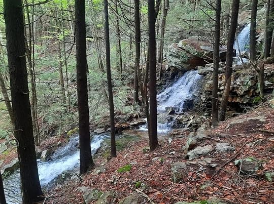 Waterfall in the cove
Parking: There is a trailhead at 41.160328, -75.734384
Length: About 1.3 miles, one way.
Trail conditions: Trails are well marked and established. No marked trail down to Buttermilk Falls.
Highlights: Two waterfalls, hemlocks, diverse forests, large rocks and ledges, scenic cove.
Difficulty: Moderate. Terrain is hilly with some steep sections. Rugged and rocky down to Buttermilk Falls.
Description: This is a short and very scenic hike at Bear Creek Preserve, a popular hiking destination in Northeast PA. From the parking area, take the green trail up the hill. Hike through laurel and blueberry thickets and reach a bench at the top of a steeper climb. The trail eases and enters a glen with hemlocks. Just off the trail is a scenic cove with giant rocks, ledges, and a beautiful falls with three drops. This creek can by dry in summer. I don’t think it, or the falls, has a name. Take time to explore the cove, probably my favorite spot on this hike. Cross above the falls under hemlocks and follow the gray trail. Hike on the top of ledges with laurel and hardwoods. Enter hemlocks again and reach Buttermilk Creek, where the gray trail ends.
Here, you can work your way downstream under hemlocks. There are also giant rocks to explore. It is off trail but various paths can be followed down the creek. There are many cascades and falls. Soon the highlight appears, towering Buttermilk Falls, an impressive sight. Be careful descending to the base, it is steep. This falls is also along the road, but it is more rewarding to hike to it, and it’s a beautiful hike, anyway. I don’t know if Buttermilk Falls is part of the preserve, but it is commonly visited by the public. Return the way you came.
If you only have time for a short hike, check this one out. It is very beautiful and if the creeks are flowing well, the waterfalls are beautiful. The preserve is owned by Natural Lands. Enjoy this beautiful place.
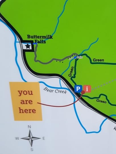 Blue dots are falls or cascades, black are ledges or large rocks.
View this post on InstagramA post shared by Jeff Mitchell-Outdoors Author (@hiking_mitch)
May 12, 2025
Waterfalls and Cascades of Sinnemahoning State Park
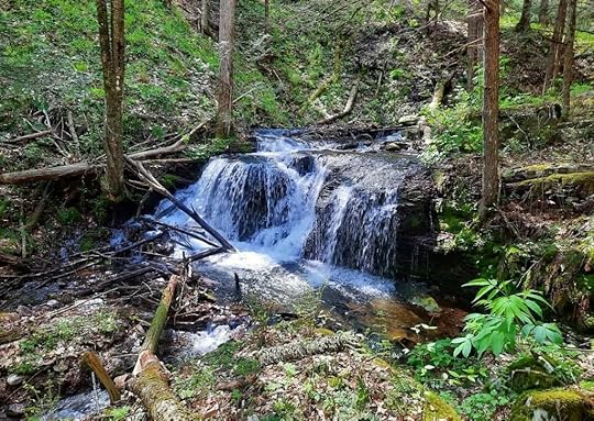 Kristine Anderson Falls
Sinnemahoning State Park is a best kept secret of PA state parks, featuring a lake, towering plateaus, rugged canyons, and fine views. It is also surrounded by an assortment of beautiful falls and cascades. Most are off trail, but the hikes to them are generally short and you only need to follow a stream. Regardless, the terrain can be rugged and you should not attempt these hikes in high water. On the other hand, some of these creeks can be a trickle in summer. All these falls are actually in the Elk State Forest, surrounding the state park. The Elk State Forest and PA Wilds are an outdoor recreation wonderland.
Brooks Run Falls: This is a roadside falls, about 4 feet tall and over 20 feet wide, it is very scenic. Drive up Brooks Run Road from PA 872, look for a pull off with split rail fencing. Park and enjoy the falls.
Balcony Falls: One of the most scenic falls when flowing well. Park at the dam, cross it, follow the road up Short Bend Run and hike off trail up its first tributary or branch. Enjoy cascades and large boulders which culminates with gorgeous Balcony Falls, featuring a huge rock outcrop and giant boulders over which the water tumbles. There are more falls upstream.
Roaring Run: Pull off parking is available at Swank Road, which appears to access the bottom of the dam. Roaring Run is a challenging, rugged hike. When there’s enough water, there are many cascades and falls. And wildflowers in spring, especially foamflower, hence the name for one of its falls. Most falls are under ten feet tall. At the top, the creek flows from under a slope of mossy boulders, and then disappears under another giant boulder, only to cascade around it; I called it Magician Falls. It wasn’t large, but was unique. There is an old grade on the north side of the creek, but parts are washed out.
Gravelly/Lick Island Run: This gorge back here is something special. You can drive back, and the road was in decent shape when I visited. Along the road, looks for giant boulders and a deep, aerated glacial blue pool fed by a cascade. At the parking area, follow the orange Bucktail Path, or Game Refuge Trail. This trail features many cascades, and boulders. Such beautiful hiking. You’ll need to go off trail and up Gravelly Run; there is an old grade. Lots of wildflowers. Reach the Falls of the Gravelly, a scenic glen with large boulders, moss, and a series of falls and cascades. The creek flows onto a boulder, and then makes a turn to tumble off. None of the cascades are more than ten feet, but it is a beautiful spot. There’s more. Follow the grade up and you’ll soon see Kristine Anderson Falls, named after a Pennsylvania environmental leader from nearby Elk County who died at a young age in 1999. It is about ten feet tall, but is notable for being a fairly wide falls.
This is a beautiful place in the PA Wilds, enjoy it!
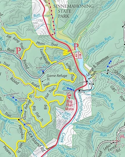 Black dots are parking or pull off areas. Blue dots are falls and cascades. Locations are approximate. Off trail hiking required to reach most of these falls.
View this post on InstagramA post shared by Jeff Mitchell-Outdoors Author (@hiking_mitch)
View this post on InstagramA post shared by Jeff Mitchell-Outdoors Author (@hiking_mitch)
View this post on InstagramA post shared by Jeff Mitchell-Outdoors Author (@hiking_mitch)
View this post on InstagramA post shared by Jeff Mitchell-Outdoors Author (@hiking_mitch)
April 30, 2025
Backpack the Loop of Meadows-Quehanna Wild Area
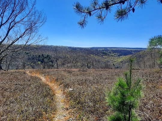 Crawford Vista
Length: About 30 miles
Parking: There are several places to park, but the main trailhead is at Beaver Run Dam. 41.261247, -78.257991
Trail blazes: Most trails are yellow, a few are red. Quehanna Trail is orange.
Trail conditions: Overall, pretty good. Trails are generally easy to follow. Most trail junctures have signs, but some do not. You’ll need to pay attention for turns. Trail is wet and muddy in places.
Terrain: Moderate and hilly. Biggest climb and descent are Porcupine and Sanders Drafts.
Issues: Nettle is a problem in Porcupine Draft in summer. Sun exposure in hot weather.
Highlights: This is a remarkably diverse and scenic loop. Extensive meadows, gorges, glens, diverse forests, cascades and falls, scenic streams, isolation, wild elk, moss forest, a few views, good campsites.
Best time to hike: May for flowers, June for mountain laurel blooms, July for rhododendron blooms, September for elk bugling, October for fall colors.
Direction of description: Clockwise from Beaver Run Dam. I think clockwise is the best way to hike the loop as it better showcases the scenery.
Description: I love when you’re hiking in the woods and then it opens up and crosses a meadow. The Quehanna has lots of meadows and I’ve wanted to create a loop that showcases all its meadows and glades. This is what I came up with. I finally hiked this loop and was blown away by its scenery and diversity. Other than Dolly Sods in West Virginia, no other loop has as much meadow hiking in the east. This loop can be a decent alternative to the very popular Dolly Sods; some sections of this loop looked very similar.
In a few miles, you can be hiking along a tumbling creek with waterfalls and mossy boulders, meadows and teaberry glades, open hardwoods, fern meadows, rhododendron tunnels, beaver ponds and dams, views, laurel jungles, forests of pine and hemlock, and even a stunning moss forest. I’ve never seen such diverse scenery packaged along a loop like this and I’m surprised this loop isn’t more famous.
From Beaver Run Dam, walk up the road and turn left onto the yellow trail. Hike through glorious pine forests. Turn left and then right on the Marion Brooks Loop with more pines and the first meadow. Cross Quehanna Highway and take a peek at the white birch forest in the Marion Brook Natural Area. Walk the road for a short bit and turn right onto Marion Brooks Loop with more meadows.
Turn right on the East Cross Connector (ECC) and follow the Teaberry Loop with more meadows and a fine view. Return to the ECC and turn right on it, heading north. Reach the Quehanna Trail (QT) and turn right. Descend Porcupine Draft with big boulders, cascades, and small falls near the bottom; lots of wildflowers too. Reach beautiful Red Run and then hike up gorgeous Sanders Draft with its fine camping and stunning collection of cascades and falls among huge boulders. What a creek.
At the top, turn right onto Sanders Trail and follow it through beautiful forests of hardwoods and hemlocks and cross a meadow. Continue to Hoover Road and turn left. Turn right onto Gore Vista Road or Trail and veer straight or right onto Gore Cut off Trail. Hike along a huge meadow. Turn left onto Bailey Log Trail with pine forests that becomes a vast jungle of laurel, which must be an impressive sight when it blooms in June.
Cross Wykoff Road and follow Wykoff Trail with hemlocks, creeks, and several meadows. Follow Ligament Trail and reach Quehanna Highway, follow the red blazes to Bellefonte Posse Trail. (No need to follow the yellow Panther Run extension trail, it simply parallels Bellefonte Posse and then rejoins it). Turn right onto Panther Run Trail, a gem. Hike into a valley with beaver dams, ponds, and meadows. Turn right onto a road and follow the yellow blazes over a hill and down into another valley with extensive meadows, huge boulders, and spruce forests in the distance. This spot looks like Dolly Sods. Enter a trail highlight, a simply stunning spruce and moss forest. You won’t believe all the moss.
Cross Reactor Road and follow Red Run Trail to Ralph Seeley Trail with more meadows. Cross Meeker Run and turn left on the ECC. Hike along Meeker Run with two campsites, a falls and deep pool. Take the trail up to Crawford Vista, a gorgeous view with dry camping. Turn left and hike down to Mosquito Creek and Bridge Trail with camping at the bridge. Follow Bridge Trail along beautiful Mosquito Creek and extensive meadows.
After crossing a small creek and before nearing the woods, I took a bushwhack to the left across meadows and along deer trails. It was totally worth it, and the brush was low. I wanted to see the oxbow loop of Mosquito Creek (at about 41.235249, -78.264989 ); the views were nonstop. Wow. I then veered up above Beaver Run and reached what I jokingly called “Dolly Sods Knob” (at about 41.237088, -78.264641 ), a stunning valley of meadows with spruce, tamarack and pine that looked like Dolly Sods. I continued along the meadows with more views, crossed a boggy area, and rejoined the ECC. If you’re up for some adventure and are comfortable with off trail hiking, consider taking the bushwhack route.
I followed the ECC along more meadows, across a beaver pond on a bridge, and along the Beaver Run Dam lake. I followed the road back to the parking area.
This loop was a stunner, one of the most diverse and beautiful in the mid Atlantic if not the east. It qualifies as one of PA’s Best Weekend Backpacking Loops. Get out there and enjoy it.
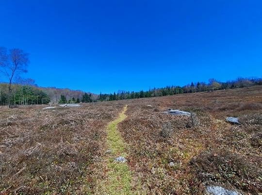 Panther Run Trail approaching the moss forest
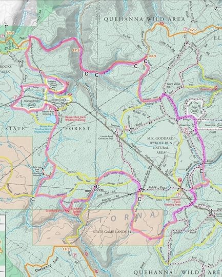 Route highlighted in purple, not marked that way on the ground. C = camping or potential camping. Blue dots are falls or cascades. Light blue dots are beaver dams and ponds. Red dots are the bushwhack I took. Locations are approximate. This map has one mistake, “moss forest” should be at the “C” on Panther Run Trail.
View this post on InstagramA post shared by Jeff Mitchell-Outdoors Author (@hiking_mitch)
View this post on InstagramA post shared by Jeff Mitchell-Outdoors Author (@hiking_mitch)
View this post on InstagramA post shared by Jeff Mitchell-Outdoors Author (@hiking_mitch)
View this post on InstagramA post shared by Jeff Mitchell-Outdoors Author (@hiking_mitch)
View this post on InstagramA post shared by Jeff Mitchell-Outdoors Author (@hiking_mitch)
April 26, 2025
East Rim Traverse-PA Grand Canyon
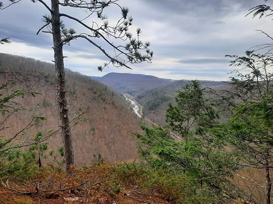 View from Snyder Point
Length: 7-8 miles one way (this should only be hiked one way, north to south)
Parking: The traverse begins at Darling Run trailhead (41.735890, -77.428706) and ends at Leonard Harrison State Park (41.697173, -77.453838). You’ll need to shuttle cars.
Direction of description: north to south, this should only be attempted in that direction.
Highlights: waterfalls, views, canyon rim walk, pine and hemlock forests.
Difficulty: This is a challenging and difficult hike, with off trail hiking and steep terrain. Scrambling required up Pinafore Run. Only experienced hikers should attempt. Do not attempt in high water. Do not descend Pinafore Run.
Description: From Darling Run trailhead (which is off the map) hike south or downstream on the Pine Creek Rail Trail. Reach Pinafore Run and hike up it, there is no trail. This run has a beautiful gorge and about ten falls or large cascades; it is very beautiful. There is extensive scrambling up along the falls. We were able to scramble along all the falls. There isn’t huge exposure, but you can fall and get hurt if you’re not careful. Do not attempt in high water. Pinafore Run might be one of the best waterfall scrambles in the state. We had a lot of fun hiking up it. Pinafore Run often dries up in summer. You should have experience scrambling to hike up Pinafore Run.
Reach a footbridge at the top and notice an old grade to the right; there may also be flagging. Regardless, hike off trail to the canyon rim. This rim walk is spectacular. There is a human or game trail and the pine and hemlock forests are just beautiful. There are some views through the trees; it is so cool to walk along the rim as the earth just falls away. Naturally, you must be careful along the rim. A fall will be deadly.
Reach Snyder Point with a fine view looking up the canyon. There is a gorgeous pine grove here. Continue along the rim, the trail seems to become a bit less established but is still followable. Again, be careful along the rim. You can do the very sketchy scramble down to Juniper Berry Rock with amazing views of the canyon. I did not go down to it.
Continue along the rim. The rim begins to descend and we moved away from it, hiking south then east. We circumvented pine plantations with picker bushes. Our route was easy to hike and the woods were fairly open. We hiked through scenic red pine plantations along the way. We reached an old and impressive stone dam and hiked down a seasonal creek. We reached a tributary of Little Fourmile Run and hiked down that, passing three falls, the tallest being about 12 feet. Next was a quick scramble up to the Turkey Path at Leonard Harrison State Park. If you want to see more falls, hike the Turkey Path down along Little Fourmile Run. It is such a stunning waterfall creek.
Otherwise, hike up the Turkey Path to the gorgeous overlooks at Leonard Harrison. Congratulations, you completed the East Rim Traverse!
While every hiker knows of the PA Grand Canyon’s West Rim, the East Rim is just as beautiful. If you’re experienced with scrambling, off trail navigation, and steep terrain, you might want to check the East Rim Traverse out.
I love the PA Grand Canyon and Pine Creek Gorge.
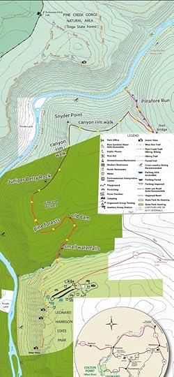 Red is off trail. Brown is faint human or game trails. Yellow dots are our route; it is not marked that way on the ground. Blue dots are waterfalls. Black dots are views or dam. Locations are approximate. Descent to Juniper Berry Rock is very sketchy. This map is for general directional purposes and is not a GPS route.
View this post on InstagramA post shared by Jeff Mitchell-Outdoors Author (@hiking_mitch)
View this post on InstagramA post shared by Jeff Mitchell-Outdoors Author (@hiking_mitch)
View this post on InstagramA post shared by Jeff Mitchell-Outdoors Author (@hiking_mitch)
View this post on InstagramA post shared by Jeff Mitchell-Outdoors Author (@hiking_mitch)
April 15, 2025
Vistas of the Garby Trail-Sproul State Forest
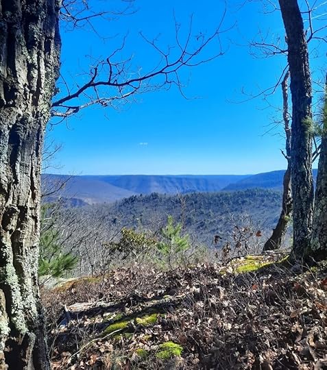 View from The Point, just off the Garby Trail
Parking: It is best to park at the boat launch. 41.323471, -77.636180
Length: To Two for One Vista, about 4 miles one way.
Blazes: Garby/Palhaumus Trails are yellow.
Difficulty: Moderate to challenging
Issues: All views are just off the Garby Trail, so bushwhacking is required.
Highlights: Beautiful streams, gorges, and three superb views.
Description: From the boat launch, hike up to PA 120, follow to the right, and turn left onto Sportsman Lane to the West Clinton Sportsmen’s Association (WCSA). Before reaching the WCSA, turn right onto the Garby/Paulhamus Trails. Hike up along a creek into a wooded gorge and cross the creek on a bridge. Climb above the creek and follow the wooded side of the gorge, pass a snowmobile trail which is also the Sproul 10k Route. Continue a steady climb up into the gorge and cross a creek with cascades and boulders. The climb continues with hemlock and moss, and nice views when the leaves are off the trees. Reach the ridge where the trail levels somewhat. Above, off trail just a few hundred feet, is The Point, a superb view. You can scramble up to it. I did notice a faint trail at the view that may go down and connect to the Garby Trail, but I did not follow it. There is a trail on the spine of the ridge, but it fades as you hike west. There is one other fine view on this spine, McCloskey Canyon Vista. You can choose which way you want to take to reach these views, but they are worth the effort.
Reach the plateau, an unblazed trail joins from the right, the Sproul 10k route. Continue on Garby Trail as it enters some laurel, so keep an eye out for blazes. The next view, to the east of the trail, is Two for One Vista. It is off trail. It is best to hike to it from the southwest to avoid the thickest laurel. You then must drop down to the point where you are treated to two views. It is a gorgeous spot.
From here, you can retrace your steps. You may choose to return via the Sproul 10k route, but I felt the Garby Trail was more scenic.
The Garby Trail is expected to be part of the PA Wilds loop trail, a 300+ mile long distance backpacking route in the PA Wilds. Hopefully these vistas can be connected to the trail system.
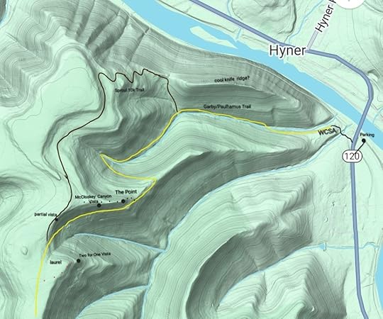 Red dots are off trail. Brown dots are a faint trail that fades west to the Sproul 10k route; it may connect to the Garby Trail but I do not know. Locations are approximate. This map is not a gps route and is for general directional purposes only.
View this post on InstagramA post shared by Jeff Mitchell-Outdoors Author (@hiking_mitch)
View this post on InstagramA post shared by Jeff Mitchell-Outdoors Author (@hiking_mitch)
View this post on InstagramA post shared by Jeff Mitchell-Outdoors Author (@hiking_mitch)
View this post on InstagramA post shared by Jeff Mitchell-Outdoors Author (@hiking_mitch)
April 6, 2025
Explore the Rocks of Flat Top-State Game Lands 57
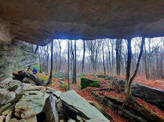 Conglomerate Cave
Length: Variable, route is up to you. You can expect to hike 6-9 miles.
Difficulty: Challenging, rocky and rugged. You should be comfortable with off trail navigation.
Scenery: Extensive rock formations, overhangs, caves, boulders, chasms, mazes. Spruce, hemlock, and moss forests.
Parking: 41.496585, -76.131970
Description: This is the hike for you if you like rock formations and features. These rock features cover Bartlett Mountain and Flat Top. This hike explores the east rim of Flat Top. The route is up to you. There are no blazes or marked trails. There are unblazed trails on old logging and jeep roads up to the top. However, a hike to the rocks is off trail. A georeferenced PDF map is attached below.
We hiked north to south along the east escarpment of Flat Top. First there was a giant overhang, cliffs, and boulders. Next was my favorite part, an area of caves and mazes in a spruce and hemlock forest. This rock area is extensive with so many cool spots to check out. Here we found an ice cave, with a floor of solid ice. This is just north of the faint, unblazed Hidden Passage Trail. Next was The Fins, three gigantic, tilting boulders. One has a striking, narrow fin. Further to the south were a series of overhangs at various sizes. Some were quite large. Finally, we reached Conglomerate Cave, a giant overhang notable for its thick pebbly conglomerate rock.
The next area we checked out were the “jenga rocks”, an escarpment of square and rectangular outcrops. The highlight here was a cave passage.
Another amazing spot in SGL 57.
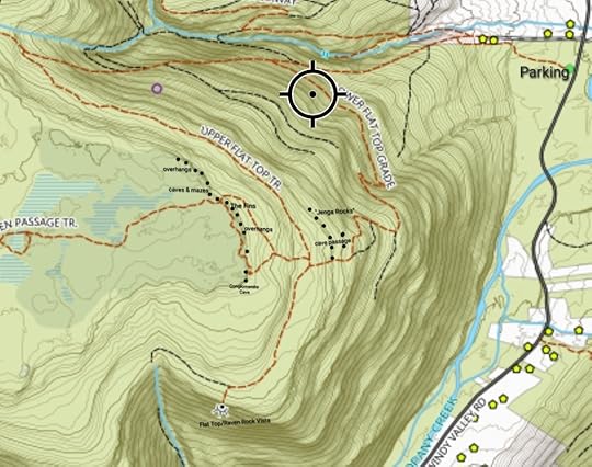 No trails are marked. Off trail hiking required. Area is rocky and rugged. Locations are approximate. Basemap by Ben VanRiper. A link to download this georeferenced PDF map is below.Bartlett MountainDownload
View this post on InstagramA post shared by Jeff Mitchell-Outdoors Author (@hiking_mitch)
View this post on InstagramA post shared by Jeff Mitchell-Outdoors Author (@hiking_mitch)
View this post on InstagramA post shared by Jeff Mitchell-Outdoors Author (@hiking_mitch)
View this post on InstagramA post shared by Jeff Mitchell-Outdoors Author (@hiking_mitch)
March 15, 2025
Backpacking the Green Monster Trail (West Loop)-Tioga State Forest
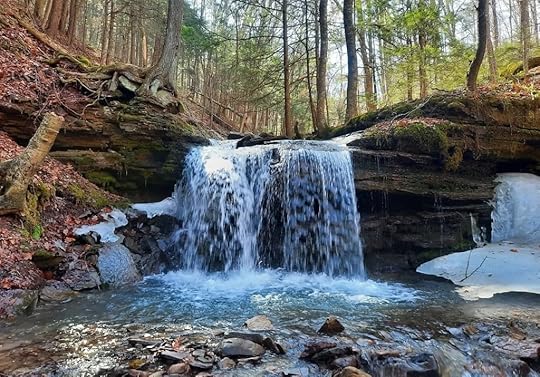 Goodall Hollow Falls. Near “B” on the map, just below the trail.
Length: My route was about 19 miles.
Parking: Small pull off at about 41.789985, -77.403264
Blazes: Yellow. Some trails are also red, or blue.
Difficulty: This is a challenging trail. Several climbs and descents. No scrambling. Many creek crossings without bridges. Easier than the Black Forest Trail. Similar to the Susquehannock Trail.
Highlights: Good isolation, lots of creeks, a good amount of hiking along or near creeks, cascades and waterfalls, hemlock forests, small meadows, wetlands, large rocks, gorges and glens, Hesselgessel Millstone, Straight Run. (Some features are just off trail)
Trail conditions: I hiked this in March and had no trouble following the route, but it can be more challenging in summer. Blazes can be faded and far apart. Not all trails have signs. Overall, the trails were in good shape and the route was followable. Some areas are wet or mucky. Bring a map and know how to read it. There are turns you need to keep an eye out for. There are many unbridged stream crossings, some are sizeable and will be very dangerous in high water.
Direction of description: Clockwise from P on map.
Camping: This loop has little established camping, but there are places where camping is possible.
Best time to hike: Mid June for amazing mountain laurel blooms. May to June for wildflowers. Mid October for fall colors. Or when the leaves are off the trees for views of the mountains, or to see down to creeks with falls and cascades.
Maintained by: Tyoga Running Club. The Green Monster Trail (GMT) was created for trail running and there is a popular race in the fall (do not hike that weekend). Hiking and backpacking are welcomed.
Description: The GMT has been on my radar for a while and I finally decided to hike it. It is a 30ish mile loop with a cross connector along Straight Run. This hike describes the west loop. I never hiked much in the Asaph area, and I was impressed by the beauty of this trail.
From P, hike south, or down, Straight Run Road to the first cabin on the right. Here is A, so marked because there are no trespassing signs and purple paint marks, indicating no trespassing. However, the sign for Darling Trail is there and the blazes weren’t painted over. So I’m guessing the public can access the trail corridor. This is the route of the GMT. Darling Trail ascends on an old grade on nice singletrack. At the top, there is a hemlock grove with potential camping. At a Y, turn left. Descend along a small creek with cascades and cross Asaph Road.
Here is B. Asaph Run is the size of a small river, there is no bridge. You can use the nearby road bridge to avoid this crossing. Climb above a small creek. Just below the trail is a beautiful falls (Goodall Hollow Falls) and an upstream cascade. Climb along the deep gorge as the creek cascades below. Go straight cross Goodall Road. At the top, turn right. Cross Goodall Road again and go across a logged area. The trail was in good shape and the open area was a change of scenery.
Descend on Frying Pan Trail into another glen with cascades. There was also a cool birch forest. Reach West Branch Asaph Run at a scenic spot. You need to cross, no bridge. The trail continues up along the run with two more stream crossings. It is scenic, with potential camping. I’m not sure if it is allowed since the road is nearby. If you want to avoid the two additional crossings, hike the road.
Ascend Big Tree Hollow, a good climb, and turn left on the top. A small meadow is to the left. The next section has cruisey terrain under big hardwoods. The trail becomes more wet and mucky near wetlands. Hemlocks become more common. You’ll need to work around some wet areas. Follow an old forest road with more wet areas. Veer right onto another old road. You can hike a short distance off trail to the pond/wetland at Black Ash Swamp under big hemlocks.
Continue on an old road. Look for the yellow blazes where they turn right off the old road. Hike above a deep gorge with falls and enter a corridor of pine and hemlocks, a beautiful section of trail. Cross a creek with potential camping. Hike up to Right Asaph Road and turn left on it. Turn right onto Hesselgessel Trail. Hike through laurel and skirt a meadow. Reach large rock outcrops and even a chasm. The historic millstone is there. The road is in a spruce grove. On the other side of the road is a large meadow wetland. Turn right on the road. Reach D. Turn left on a logging road, and hike for about 200 feet. Then turn left on the yellow trail into the laurel. There are wet areas. Veer left onto a forest road, hike along a logged area and reach a pipeline with a view. Turn right onto the red trail before the pipeline. Descend gradually on an old forest road to Straight Run. There is potential camping along Straight Run, but nothing established.
Straight Run is the highlight of the loop. When I hiked the GMT, I intended to do the whole loop as a figure 8; I planned to hike the cross connector twice. But Straight Run was so scenic, I couldn’t rush it and decided to come back to do the east loop.
There are side stream waterfalls just off trail, and Straight Run has cascades, pools, and waterfalls as well. It is sublime, blissful creekside hiking. And there are a lot of crossings without bridges. I absolutely loved this creek, a true joy. As you head down the creek, reach larger falls (though none are more than 10 feet tall), slides, and an impressive turquoise pool. There’s are falls in a bedrock grotto shortly before the Deer Trail. Reach your car at Straight Run Road.
The most scenic part of the GMT is the Straight Run cross connector, do not miss it.
I was impressed by this loop. It has a great mix of challenge, isolation, scenic and even historic features. I loved all the various creeks and streams, different forest types, deep glens, and gorgeous Straight Run. I will surely hike it again. I think it qualifies as one of the Best Weekend Backpacking Loops in PA.
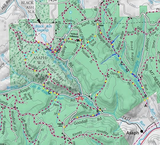 Locations are approximate. Basemap from Tioga State Forest.
Legend:
Yellow dots: the route, hiked clockwise from P.
C: potential camping
P: parking
Blue dots: falls, slides, or large cascades. Some are just off trail.
Black dots: Hesselgessel Rocks
Light blue dots: wet, muddy areas
Short red lines: off trail hikes I did
View this post on InstagramA post shared by Jeff Mitchell-Outdoors Author (@hiking_mitch)
View this post on InstagramA post shared by Jeff Mitchell-Outdoors Author (@hiking_mitch)
View this post on InstagramA post shared by Jeff Mitchell-Outdoors Author (@hiking_mitch)
View this post on InstagramA post shared by Jeff Mitchell-Outdoors Author (@hiking_mitch)
March 2, 2025
Caves, Rocks, and Overhangs of White Brook-SGL 57
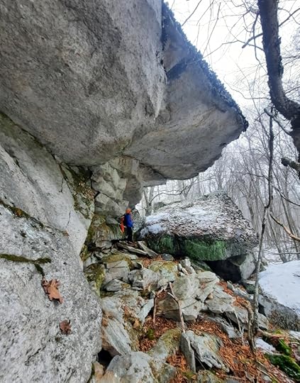 The overhangs
Length: Various, route is up to you. You can expect to hike 5-6 miles.
Difficulty: Challenging. Terrain is rocky and rugged with cliffs and ledges. There is a significant climb up to the rocks.
Parking: parking area at 41.496557, -76.131983
Highlights: Huge rocks, mazes, chasms, caves, overhangs, boulders. Waterfalls and cascades.
Description: I’ve known of these rocks for years, but never explored them. I’ve hiked by them dozens of times. I finally went. It’s incredible how much beauty SGL 57 has after exploring it for almost 20 years.
I do not describe a route, that is up to you. There are no signed or blazed trails. The map below highlights old forest roads and grades, which are generally easy to follow. The rocks are off trail and the terrain is rugged. I will describe the highlights.
We hiked the rocks from north to south. The first area is the overhangs and Glazed Cave. These are among the largest rocks on the hike. Enjoy the beauty. The rocks are huge as are the jutting overhangs. To reach the Glazed Cave, you must scramble up a steeply sloping 6 foot boulder wedged between the rocks and go into an open chasm with a big birch tree. The cave is so named because one side was glazed with sheets of ice. The cave has a roof and jumbled rock, with another passage underneath it. A beautiful and unique spot.
The large rocks continue. The next spot is Comma Rock, as it kind of resembles a comma. The rocks recede a little and then we entered a very unique cove-the Rocks of the Springs. This place has a Zen vibe to it. Numerous springs trickle and cascade within the ledges and cliffs and flow from the base.
The rocks recede and we hiked south, nearing White Brook. We then entered cliffs, ledges, and the boulder maze. These rocks weren’t gigantic, but the all the rooms, passages, and caves, made it a highlight. I called it the Maze of Infinity because it was that surprising. It’s actually not that large of an area, but it is packed with nooks and crannies. Nearby, White Brook cascaded over the rocks.
Nearby was the unmarked trail up White Brook, which we took back down. Enjoy this amazing place.
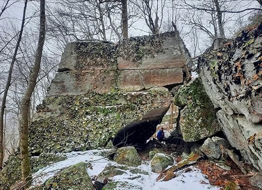 Comma Rock
 Black dots are rocks. Blue are cascades or falls. No trails are marked or blazed. This map shows locations of unmarked trails, old logging roads, and grades. Locations are approximate. Rocks are off trail. Base map by Ben Van Riper.
View this post on InstagramA post shared by Jeff Mitchell-Outdoors Author (@hiking_mitch)
View this post on InstagramA post shared by Jeff Mitchell-Outdoors Author (@hiking_mitch)
View this post on InstagramA post shared by Jeff Mitchell-Outdoors Author (@hiking_mitch)
View this post on InstagramA post shared by Jeff Mitchell-Outdoors Author (@hiking_mitch)
View this post on InstagramA post shared by Jeff Mitchell-Outdoors Author (@hiking_mitch)
View this post on InstagramA post shared by Jeff Mitchell-Outdoors Author (@hiking_mitch)
January 31, 2025
Explore the Escarpments of Ricketts Glen State Park
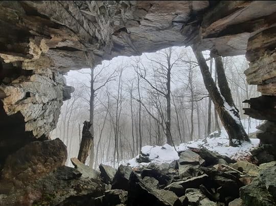 Jigsaw Cave
Length: Various on where you park and hike. You can expect to hike up to about ten miles.
Difficulty: This is a difficult hike with rocky, rugged terrain, cliffs and ledges. All hiking along the escarpments is off trail. Expect brush and steep terrain.
Parking: Beach Lot No. 2 at Ricketts Glen. You can also begin from Mountain Springs Road but I did not come in that way.
Highlights: cliffs, ledges, boulders, ice flows, seasonal falls, cave, overhangs.
Description: Pennsylvania is a state of hidden beauty. This place is an example of that. We all know Ricketts Glen for its magnificent waterfalls, but it is so much more, with cliffs, overhangs, and caves.
I began this hike from the Beach Lot No. 2 parking area because I wanted to see ice flows. You can also begin from Mountain Springs Road for a shorter hike, but that road is not maintained in winter.
The Cherry Run Escarpment is on the west side of Cherry Run. It has no views, but does have a very scenic hemlock forest on top. Cliffs rise to about 50 feet or more, with shorter ledges. There is a seasonal falls on its southern end and what I call the Tangerine Wall, a series of ice flows, over a hundred feet long, with a citrus color. You will also see one huge overhang. Jumbled boulders with moss and ferns are common along the base.
The Bowmans Creek Escarpment is incredible, particularly the southern half. There might be a view on top, but the laurel was so thick, we didn’t find one. This escarpment is just off the unofficial Hall of Hemlocks Trail. You must go off trail to the base of the escarpment. From the north, there are giant cliffs and ledges, with a base of jumbled rock. Reach a massive overhang. As you continue south, the scenery picks up. Reach a seasonal falls, Sometimes Falls, maybe 20 feet tall. Around the corner is the Cove, a special place with ledges and ice flows in winter. Here, is one of the entrances of Jigsaw Cave, which goes through the cliff. Work around a protruding cliff to the impressive entrance of Jigsaw Cave; it is remarkable. Huge cliffs and overhangs continue, until the cliffs and ledges reduce in size with more laurel and hemlock.
Enjoy this beautiful, rugged place.
Ricketts Glen has a lot more cool rocks and cliffs.
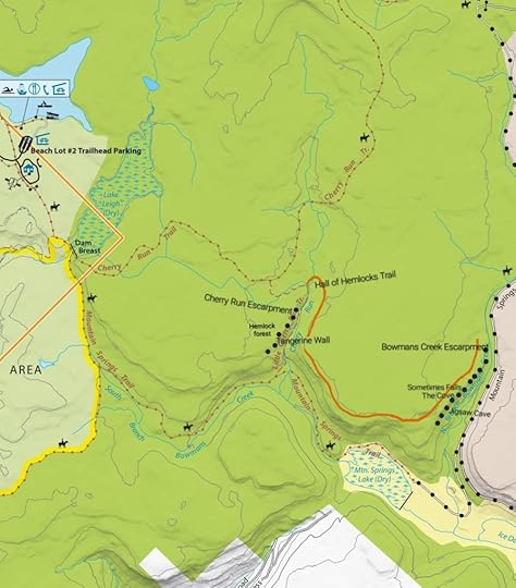 This sketch map is for general directional purposes only, locations are approximate.
View this post on InstagramA post shared by Jeff Mitchell-Outdoors Author (@hiking_mitch)
View this post on InstagramA post shared by Jeff Mitchell-Outdoors Author (@hiking_mitch)
View this post on InstagramA post shared by Jeff Mitchell-Outdoors Author (@hiking_mitch)
View this post on InstagramA post shared by Jeff Mitchell-Outdoors Author (@hiking_mitch)
View this post on InstagramA post shared by Jeff Mitchell-Outdoors Author (@hiking_mitch)
View this post on InstagramA post shared by Jeff Mitchell-Outdoors Author (@hiking_mitch)
Jeff Mitchell's Blog
- Jeff Mitchell's profile
- 3 followers


