
Jeff Mitchell's Blog, page 23
May 10, 2019
Sand Run Falls and the Gorges of Babb Creek-Tioga State Forest
Yellow are the unblazed but well established trails. Orange is the Mid State Trail.
The eastern part of the Tioga State Forest is not as famous as the Pine Creek Gorge, but it has remarkable natural beauty. Here you will find impressive gorges and waterfalls. No hiker should miss Sand Run Falls and the gorges of Babb Creek.
Most people hike into Sand Run Falls along the Mid State Trail from SR 2016. While that is a great hike, there is a much shorter and arguably more scenic route along an unblazed but obvious trail from Landrus Road. The pull off parking is marked with a tree painted with a variety of colors. The trail starts just down the road and descends along switchback to the bottom of the valley. Hike through a grove of ironwood trees and reach Lick Run. You will need to make two stream crossings without bridges. Expect wet feet in higher water.
The trail continues up along Babb Creek and it is beautiful, passing under hemlocks and above the creek, which is often framed with cliffs and ledges. Climb gradually up the stream valley and reach thicker hemlocks and some wet areas. Babb Creek hides from view, flowing in a gorge.
Reach a place where the trail splits; I took the left trail which drops down a steep slope with a rope to Babb Creek. The beauty is amazing with gorges and cliffs, no more than 50 feet deep. Springs tumbled down the ledges. I hiked up along Babb Creek, passing an impressive grotto to the right with a falls. I continued and crossed Sand Run to take in the beauty of San Run Falls.
This is a gorgeous falls set in an impressive gorge with incredible campsites. The roar of water surrounded me, confined within the gorge walls. I felt as if I were within a hidden world. I climbed a trail up a steep slope on the north side of the gorge and turned left onto the orange blazed Mid State Trail (MST). The MST is an awesome hiking trail through this area, offering views down into the gorges. The trail descended to Babb Creek above a bedrock slide and waterfalls downstream. Do not cross here in high water. The MST climbed a ridge with views of another falls on a tributary. I hiked the MST to where it crossed the tributary, where I turned around.
Back at the Babb Creek crossing, I went off trail and hiked up Babb Creek. I highly recommend you do this if the water isn’t high. The beauty is amazing with several bedrock slides, pools, cascades, and gorges. This section has attracted the attention of whitewater kayakers (see the video below).
I then turned around and hiked the MST back the way I came. I stayed on the MST as it crossed above Sand Run Falls. I then hiked off trail up Sand Run to see more gorges, cascades, pools, and rapids. This area is incredible. I returned to the MST, hiked down it for a short distance, and then turned right off the MST and onto the unblazed trail. I then retraced my steps back to the car.
This hike is about 1.5 miles, one way. It is moderate in difficulty and there are some steep slopes. Do not attempt in high water as there are no bridges.
I parked at approximately 41.653248, -77.193058.
Photos and videos:
View this post on Instagram
Falls in a grotto, this is just off the Mid State Trail.
A post shared by Jeff Mitchell-Outdoors Author (@hiking_mitch) on Apr 16, 2019 at 1:06pm PDT
View this post on Instagram
Approaching Sand Run Falls. The Mid State Trail is above the falls.
A post shared by Jeff Mitchell-Outdoors Author (@hiking_mitch) on Apr 16, 2019 at 1:53pm PDT
View this post on Instagram
A post shared by Jeff Mitchell-Outdoors Author (@hiking_mitch) on Apr 16, 2019 at 3:25pm PDT
View this post on Instagram
Profile of Sand Run Falls, it was roaring.
A post shared by Jeff Mitchell-Outdoors Author (@hiking_mitch) on Apr 16, 2019 at 4:50pm PDT
View this post on Instagram
Sand Run Falls. The Babb Creek area is a hidden gem.
A post shared by Jeff Mitchell-Outdoors Author (@hiking_mitch) on Apr 16, 2019 at 5:00pm PDT
View this post on Instagram
The Mid State Trail along Sand Run and Babb Creek is absolutely beautiful. Hike it.
A post shared by Jeff Mitchell-Outdoors Author (@hiking_mitch) on Apr 16, 2019 at 5:07pm PDT
View this post on Instagram
Babb Creek is a stream of incredible beauty with many bedrock slides. Mid State Trail.
A post shared by Jeff Mitchell-Outdoors Author (@hiking_mitch) on Apr 16, 2019 at 5:51pm PDT
View this post on Instagram
Crossing Babb Creek on the Mid State Trail. No bridge equals wet feet.
A post shared by Jeff Mitchell-Outdoors Author (@hiking_mitch) on Apr 17, 2019 at 1:41pm PDT
View this post on Instagram
Another falls on a trib to Babb Creek along the Mid State Trail. Tioga State Forest.
A post shared by Jeff Mitchell-Outdoors Author (@hiking_mitch) on Apr 17, 2019 at 1:45pm PDT
View this post on Instagram
More bedrock slides, Babb Creek, Mid State Trail. Tioga State Forest.
A post shared by Jeff Mitchell-Outdoors Author (@hiking_mitch) on Apr 17, 2019 at 1:49pm PDT
View this post on Instagram
Babb Creek wonderland. So much beauty in the PA Wilds. Mid State Trail, Tioga State Forest.
A post shared by Jeff Mitchell-Outdoors Author (@hiking_mitch) on Apr 17, 2019 at 2:02pm PDT
From scott.martin.images:
View this post on Instagram
A post shared by Scott Martin | Photographer (@scott.martin.images) on Apr 21, 2019 at 8:26am PDT


May 2, 2019
Big Run Gorge Vista-Ricketts Glen State Park
Red is off trail. Yellow is off trail but also along bear paths.
Ricketts Glen is a famous state park full of secrets. There are hidden waterfalls and vistas, deep hemlock forests and diverse wetlands. These wonders remain hidden due to the overwhelming popularity of the Falls Trail. One such secret is the rim above Big Run. Here, there are extensive cliffs and ledges with a couple fine views. The final view, Big Run Gorge Vista, is stunning as it overlooks the gorge and the vast plateaus of SGL 13.
This hike is off trail, but bear paths along the rim do provide some guidance. It is hoped this corridor will be the route of the proposed Endless Mountains Trail. We parked at the boat launch as Lake Jean was shrouded in mist. Across the water we heard the unmistakable, piercing call of a loon. We hiked a grassy dike and then crossed PA 487 to walk down Jamison City or Sullivan Falls Road. We walked the dirt road for about 2,000 feet, and then turned left into the woods, off trail, and reached Big Run. We then hiked up a beautiful, narrow glen with hemlocks and small cascades. From there we followed the contour of the plateau to the west, staying above the ledges and cliffs. As we hiked, hemlocks became more common and we could discern a bear path. This path provided, at times, some easier hiking.
We explored ledges and overhangs. We reached a view across the gorge created by a landslide. Just further was an outcropping of cliffs where there was a window view through the hemlocks of the gorge to the west. The terrain was rugged and wild. As we hiked, the clouds lifted to reveal a beautiful, sunny day. We then reached a second cliff and the finest view. We had to battle mountain laurel to reach it, but there it was, Big Run Gorge Vista, offering a superb panorama of the gorge and plateaus. We sat there to enjoy the sublime beauty. Big Run roared below us. This whole area is so beautiful with deep gorges, waterfalls, vistas, and hemlocks.
This hike is ideal for experienced hikers. Be careful along the cliffs and ledges along the rim of the gorge.
We followed the bear path further west into stunning forests of moss, hemlocks, laurel, and even rhododendron. The isolation made it that much more special. If you are even more ambitious, you can explore the gorge of Lead Run on the western boundary of the park. There are falls, cascades, and partial views.
What are some of Ricketts Glen’s other secrets? A beautiful 15 foot falls on Maple Run, just below PA 487. Four or five falls on stunning Maple Spring Run, including the phenomenal Porcupine Falls. A 30-40 foot falls on Shingle Cabin Brook. Views off the Old Bulldozer Road Trail. And stunning views over Phillips Creek on the eastern boundary of the park.
Ricketts Glen State Park is more beautiful than you ever imagined.
We parked at 41.336952, -76.302129. Big Run Gorge Vista is as approximately 41.335150, -76.319138.
The hike is about 2 miles, one way.
View this post on Instagram
I heard loons this morning at Lake Jean! Incredible.
A post shared by Jeff Mitchell-Outdoors Author (@hiking_mitch) on Apr 6, 2019 at 11:06am PDT
View this post on Instagram
A post shared by Jeff Mitchell-Outdoors Author (@hiking_mitch) on Apr 6, 2019 at 11:14am PDT
View this post on Instagram
Landslide Vista, Big Run Gorge.
A post shared by Jeff Mitchell-Outdoors Author (@hiking_mitch) on Apr 6, 2019 at 11:19am PDT
View this post on Instagram
A post shared by Jeff Mitchell-Outdoors Author (@hiking_mitch) on Apr 6, 2019 at 11:22am PDT
View this post on Instagram
Big Run Gorge. Awesome hike along ledges and hemlocks on a bear path. Clouds began to lift.
A post shared by Jeff Mitchell-Outdoors Author (@hiking_mitch) on Apr 6, 2019 at 6:53pm PDT
View this post on Instagram
This was incredible. Big Run Gorge Vista. PA has so many hidden gems.
A post shared by Jeff Mitchell-Outdoors Author (@hiking_mitch) on Apr 6, 2019 at 6:58pm PDT
View this post on Instagram
Big Run Gorge Vista. Big Run was roaring far below as mist rose across the distant mountains.
A post shared by Jeff Mitchell-Outdoors Author (@hiking_mitch) on Apr 6, 2019 at 7:17pm PDT
View this post on Instagram
A post shared by Jeff Mitchell-Outdoors Author (@hiking_mitch) on Apr 7, 2019 at 5:58am PDT
April 29, 2019
Hounds and Hawk Runs-McIntyre Wild Area
Red is off trail. Yellow is an old skid trail.
The McIntyre Wild Area has acquired a reputation for its scenery and historical significance. The wild area features old mines, ruins, cemetery, vistas, and beautiful gorges with waterfalls. A few weeks ago, I decided to head out and explore the isolated eastern section of the wild area, along Hounds and Hawk Runs. Most of this hike was off trail, but there were many old grades.
I parked along Yellow Dog Road, right before it crosses Rock Run. I then hiked down the road until I reached Hounds Run. I hiked up the run. There were some old grades, but they didn’t last long and I simply followed the creek, crossing where I needed. I entered a deeper gorge with a unique rock outcrop on the right and some cascades. Ahead, the gorge opened up to reveal a broad seven foot falls over a ledge. I hiked upstream to see impressive Hounds Run Falls. I had not been to this falls in about ten years and I forgot just how beautiful it was. It is over thirty feet tall and set in a scenic gorge with boulders and smooth bedrock. I climbed up to the left of the falls.
I continued upstream and soon reached a scenic glen with slides and smaller falls. A beautiful spot. I continued up along the east side of Hounds Run, staying above the creek. At the two forks, there were some cascades on the west fork, but I continued on the east fork, again following grades where I could. After hiking through some hemlocks, the forest opened into hardwoods. I crossed more grades and saw a small, unique stone culvert. I followed the creek to the east and stopped at a wetland, with rocks to the east, or my right. I then headed right, reaching a small rock bald, and below, an impressive boulder maze coated with wet moss. Truck and cottage sized boulders adorned the forest floor. On one boulder, trees were growing out of the draperies of moss. I angled slightly southeast and reached an old skid trail, which provided a convenient descent to Hawk Run.
I then hiked down Hawk Run, crossing wherever I needed. I soon reached a stunning gorge, about 100 feet deep with cascades and slides. Large boulders rose over the water. It was incredibly beautiful and rivaled any spot on Rock Run. Downstream was a glen, smaller in size, but with a ten foot falls and a deep pool. An old stone retaining wall was across the creek, but part of it had collapsed. The glen, like the gorge upstream, was very beautiful. I continued downstream, passing slides and pools. I reached a cabin with a wooden footbridge. I then hiked the road out, back to my car, surrounded by the roar of Rock Run in the deep gorge below me.
This was an excellent hike for the experienced hiker who has GPS or other navigation app. There are many stream crossings, so do not attempt in high water. The isolation, waterfalls, slides, cascades, and boulder maze make it a very unique and beautiful hike. Overall, the terrain is moderate, but the skid trail descent is a little steep.
Entire loop is about 4.5 miles.
Some GPS coordinates:
Parking: 41.535103, -76.891830
Hounds Run Falls: 41.537340, -76.898199
Boulder maze: 41.554078, -76.885617
Gorge on Hawk Run: 41.549866, -76.879359
Glen on Hawk Run: 41.547986, -76.879141
Photos:
View this post on Instagram
First falls while hiking up Hounds Run, McIntyre Wild Area, Loyalsock State Forest.
A post shared by Jeff Mitchell-Outdoors Author (@hiking_mitch) on Mar 31, 2019 at 6:32am PDT
View this post on Instagram
Hounds Run Falls. McIntyre Wild Area, Loyalsock State Forest.
A post shared by Jeff Mitchell-Outdoors Author (@hiking_mitch) on Mar 31, 2019 at 6:36am PDT
View this post on Instagram
A post shared by Jeff Mitchell-Outdoors Author (@hiking_mitch) on Mar 31, 2019 at 7:15am PDT
View this post on Instagram
A post shared by Jeff Mitchell-Outdoors Author (@hiking_mitch) on Mar 31, 2019 at 7:19am PDT
View this post on Instagram
Hounds Run Falls, McIntyre Wild Area, Loyalsock State Forest.
A post shared by Jeff Mitchell-Outdoors Author (@hiking_mitch) on Mar 31, 2019 at 8:48am PDT
View this post on Instagram
A post shared by Jeff Mitchell-Outdoors Author (@hiking_mitch) on Mar 31, 2019 at 4:24pm PDT
View this post on Instagram
Looking down the beautiful mini gorge on Hounds Run, McIntyre Wild Area, Loyalsock State Forest.
A post shared by Jeff Mitchell-Outdoors Author (@hiking_mitch) on Mar 31, 2019 at 4:27pm PDT
View this post on Instagram
A post shared by Jeff Mitchell-Outdoors Author (@hiking_mitch) on Mar 31, 2019 at 4:43pm PDT
View this post on Instagram
A post shared by Jeff Mitchell-Outdoors Author (@hiking_mitch) on Mar 31, 2019 at 4:48pm PDT
View this post on Instagram
A post shared by Jeff Mitchell-Outdoors Author (@hiking_mitch) on Mar 31, 2019 at 6:53pm PDT
View this post on Instagram
A post shared by Jeff Mitchell-Outdoors Author (@hiking_mitch) on Apr 1, 2019 at 2:38pm PDT
View this post on Instagram
A post shared by Jeff Mitchell-Outdoors Author (@hiking_mitch) on Apr 1, 2019 at 2:43pm PDT
View this post on Instagram
Footbridge across Hawk Run, McIntyre Wild Area, Loyalsock State Forest.
A post shared by Jeff Mitchell-Outdoors Author (@hiking_mitch) on Apr 1, 2019 at 2:52pm PDT
View this post on Instagram
Few streams are more beautiful than Rock Run, an Appalachian gem. Loyalsock State Forest.
A post shared by Jeff Mitchell-Outdoors Author (@hiking_mitch) on Apr 1, 2019 at 2:58pm PDT
April 10, 2019
Hiking to Cider Run Ledges and Coyote Rocks Vista-SGL 57
Yellow is the unblazed, unmarked trails.
The upper watershed of Bowmans Creek in SGL 57 features an extensive system of trails that lead to vistas, cliffs, cascades, and spruce forests. These trails are not blazed or signed, but they are fairly well established. I believe they were initially created by mountain bikers and have been in existence for over twenty years. This system offers excellent hiking and is an ideal destination for those looking for something different, but do not want to bushwhack.
Over the year, I hope to explore the entire trail system. On this hike, I did a 9 mile out and back hike to Cider Run Ledges and Coyote Rocks vista. I began at the parking area at Beth Run. I walked the road to the east a short distance, to a small pull off on the left, and followed the trail. The trail entered a scenic hardwood forest with ground pine and then made a gradual climb along an old grade. I reached the top, where a small cairn marked a trail juncture. I took the trail to the right, which goes to Cider Run Ledges. This trail may be a little hard to follow but as I hiked it became more obvious. It reached the edge of the plateau for a scenic “ridge walk” as it explored the top of the ledges. There were no open views, but the difference in terrain made for a very enjoyable hike. The trail then meandered near some spruce and then headed north, passing a boulder maze which was off to the right.
The trail descended gradually along an old railroad grade and passed more spruce. I hiked near some small streams and entered a scenic spruce tunnel. I crossed more small streams and passed near a wetland. The trail continued in a hardwood forest as ledges became more prominent. I soon reached the top of the Cider Run Ledges with the white conglomerate rock and spruce forests. There are no open views, but the isolated setting, large ledges, moss, and spruce made for great scenery. The trail continued north and I believe it may connect to Opossum Brook Road or the High Knob Trail. I stopped at the Cider Run Ledges.
I went off trail to explore the base of the ledges, something that I recommend you do. The scenery is excellent with mossy chasms, giant boulders, rock overhangs, small caves, and narrow crevices. I then retraced my steps back to the trail juncture.
I then turned right on the trail to the base of some large cliffs. The trail went around the cliffs and scrambled up some ledges in a tunnel of laurel. I then crossed the bedrock top of the cliffs with some spruce. Another beautiful spot on this trail. There was a view to the east. The trail entered the woods and meandered until it reached the edge of cliffs with views. The views culminated at Coyote Rocks Vista, a breathtaking spot where I could look up the broad Bowmans Creek valley. Giant angled boulders were beneath the vista. This view has no development, feels wild, and is great for sunsets. I then retraced my steps back to Beth Run as the forests faded into the twilight.
Back at the car, be sure to hike to Beth Run and see its cascades and grotto where it flows into Bowmans Creek.
These trails are a pleasure to hike. They are easiest to follow from late Spring, when plant growth begins, to before when the leaves fall in Autumn. The trails will be hard to follow with heavy leaf cover or snow.
GPS coordinates:
Parking at Beth Run: 41.361562, -76.165355
Where trail begins off the road: 41°21’46.16″N 76° 9’52.12″W
Cider Run Ledges: 41.387794, -76.169494
Cliff: 41.363398, -76.180046
Coyote Rocks Vista: 41.358615, -76.189458
Photos:
View this post on Instagram
A post shared by Jeff Mitchell-Outdoors Author (@hiking_mitch) on Apr 7, 2019 at 5:34pm PDT
View this post on Instagram
Cave at Cider Run Ledges, SGL 57.
A post shared by Jeff Mitchell-Outdoors Author (@hiking_mitch) on Apr 7, 2019 at 5:37pm PDT
View this post on Instagram
There is still snow deep in the chasms at Cider Run Ledges, SGL 57.
A post shared by Jeff Mitchell-Outdoors Author (@hiking_mitch) on Apr 7, 2019 at 5:40pm PDT
View this post on Instagram
Moody view from Coyote Rocks, looking up Bowmans Creek into Ricketts Glen State Park. SGL 57.
A post shared by Jeff Mitchell-Outdoors Author (@hiking_mitch) on Apr 7, 2019 at 5:53pm PDT
View this post on Instagram
Chasms at Cider Run Ledges, SGL 57.
A post shared by Jeff Mitchell-Outdoors Author (@hiking_mitch) on Apr 7, 2019 at 6:05pm PDT
View this post on Instagram
Beautiful Beth Run tumbles into Bowmans Creek. SGL 57. Happy Spring!
A post shared by Jeff Mitchell-Outdoors Author (@hiking_mitch) on Mar 20, 2019 at 4:16pm PDT
View this post on Instagram
Views across the highlands of SGL 57.
A post shared by Jeff Mitchell-Outdoors Author (@hiking_mitch) on Mar 20, 2019 at 4:04pm PDT
View this post on Instagram
Big cliffs above the trail. SGL 57.
A post shared by Jeff Mitchell-Outdoors Author (@hiking_mitch) on Mar 20, 2019 at 4:00pm PDT
View this post on Instagram
A post shared by Jeff Mitchell-Outdoors Author (@hiking_mitch) on Mar 20, 2019 at 1:08pm PDT
View this post on Instagram
Chasms in SGL 57, above Cider Run.
A post shared by Jeff Mitchell-Outdoors Author (@hiking_mitch) on Dec 30, 2018 at 10:19am PST
View this post on Instagram
After crawling through a narrow portal, we came upon this beautiful slot canyon. SGL 57.
A post shared by Jeff Mitchell-Outdoors Author (@hiking_mitch) on Dec 30, 2018 at 10:25am PST
March 26, 2019
Hike to Kelsey Falls-Loyalsock State Forest
Yellow is a gated forest road. Red is a bushwhack. Blue is an old skid trail.
The Loyalsock State Forest is home to dozens of waterfalls. Some are well-known, others are virtually unknown. I recently went on a hike into a rugged gorge northwest of Worlds End State Park to see if such a falls existed. I parked at a pull off along Loyalsock Road and followed a forest road that was gated. The forest road crossed an area that had been logged. Where the road began to curve around to the right, I left the road to begin a bushwhack into a hemlock forest and down along some ledges.
I dropped down to a small stream that had carved a mini-glen with small cascades. I followed this creek down and entered a scenic area with several large car and truck sized boulders. The small creek flowed around some of them. I angled to the northwest and continued a moderate descent, crossed a seasonal run-off streambed, and came across a skid trail, marked by what looked like a shallow ditch that went straight down the mountain. These trails were used in the lumber era to skid or slide logs down to the valley.
The skid trail was fairly easy to follow as it descended into a beautiful hemlock forest. Off to my left was the deep, rugged gorge where I hoped to find a waterfall. The skid trail moved closer to the edge of the gorge as it continued its steep descent. Near the bottom, the skid trail crossed into private land, so I dropped down to my left. I soon reached the unnamed creek and a beautiful 20-25 foot falls set in a grotto. The falls featured some bedrock cascades, then a free fall, followed by a steep slide. It was a very photogenic falls and it was possible to walk behind the falls. The falls was in the state forest, although a private property line crossed downstream from it. It appeared no one really visited the falls as there were no signs of a path. I called it Kelsey Falls. The bright sun was less than ideal for photography, but this falls would be stunning with some long exposure shots.
There appeared to be no more waterfalls downstream. I retraced my steps back to my car. This hike is about 1.5 miles one way, and requires a 700 foot vertical descent down and back up the gorge. It is a scenic hike, but only experienced hikers should attempt it. No trails are marked or blazed. Maybe someday a trail will be built from Forksville to the falls. It would make a nice tourist attraction for Forksville, and a much easier hike.
The falls are likely dry in summer. It is best to see it when the USGS Loyalsock Creek gauge is 3.5 feet or higher.
I parked at 41.487216, -76.588058 to begin the hike. The falls are located at about 41.494702, -76.591438.
View this post on Instagram
A post shared by Jeff Mitchell-Outdoors Author (@hiking_mitch) on Mar 23, 2019 at 3:04pm PDT
View this post on Instagram
Kelsey Falls, Loyalsock State Forest.
A post shared by Jeff Mitchell-Outdoors Author (@hiking_mitch) on Mar 23, 2019 at 3:08pm PDT
View this post on Instagram
Kelsey Falls, Loyalsock State Forest.
A post shared by Jeff Mitchell-Outdoors Author (@hiking_mitch) on Mar 23, 2019 at 4:22pm PDT
View this post on Instagram
A post shared by Jeff Mitchell-Outdoors Author (@hiking_mitch) on Mar 23, 2019 at 4:27pm PDT
View this post on Instagram
Trees and giant rocks. Loyalsock State Forest.
A post shared by Jeff Mitchell-Outdoors Author (@hiking_mitch) on Mar 23, 2019 at 4:37pm PDT
View this post on Instagram
Top of Kelsey Falls. Loyalsock State Forest.
A post shared by Jeff Mitchell-Outdoors Author (@hiking_mitch) on Mar 25, 2019 at 8:54am PDT
March 21, 2019
Hiking the Bear Creek Preserve Loop-Natural Lands
[image error]
Bear Creek Preserve is located south of Wilkes Barre, along PA 115 and is owned by Natural Lands. The preserve covers almost 3,600 acres and features miles of hiking trails. Bear Creek Preserve is a part of a network of protected lands that now covers 150,000 acres across the Pocono region. Over the years, it has become a popular outdoor destination with its overlook, cascades, waterfalls, and large rocks. The highlight is beautiful Shades Creek and its rapids, cascades, pools, giant hemlock and pine, rhododendron jungles and a swinging bridge.
All the trails at the preserve have a certain color. My favorite loop is one that follows the yellow, green, red, and gray trails. From the parking area we went up the hill along the yellow trail and followed a road for a short distance. We then veered right off the road into the woods with hardwoods and laurel. The terrain was rolling and enjoyable to hike. Where the yellow trail split, we turned left and hiked to a nice view from some rock ledges. The view looked over the valley of Shades Creek. The trail followed the top of the rock ledges and then met a green trail, where we turned left. The green trail descended and met the red trail, where we turned right and hiked to a small stream with a footbridge and a nice cascading waterfall just downstream.
The red trail explored hardwoods with laurel and rock outcrops. We descended to rhododendrons along Shades Creek and turned left onto the gray trail. We crossed the swinging bridge and followed the gray trail up along the creek with excellent scenery. There were waterfalls, cascades, deep pools, giant hemlock and pine, and extensive rhododendron jungles. The streamside hiking was exceptional. In places, the forests were stunning with the large trees, moss, and the pristine creek. Shades Creek flowed along ledges with pools and stairstep cascades. The trail moved away from the creek and into hardwoods, but then returned to more rhododendrons.
We reached a side trail that led to a view across Shades Creek of a 15 foot falls formed on a tributary. The trail climbed up through the jungles of rhododendrons above the creek, passing more large hemlocks, and a seasonal stream with a cascade. We crossed a log footbridge, turned right on the red trail, and returned to the car.
Bear Creek Preserve is a truly beautiful place to explore. The trails are in good shape, well marked, and most stream crossings have bridges. Some areas are wet, and you can miss some trail junctures if you are not paying attention. Take time you go hiking, be sure to check out Bear Creek.
We parked at 41.182291, -75.704073. The loop is about 4-5 miles long.
View this post on Instagram
A post shared by Jeff Mitchell-Outdoors Author (@hiking_mitch) on Mar 17, 2019 at 4:18pm PDT
View this post on Instagram
All the waterfalls were flowing great at Bear Creek Preserve.
A post shared by Jeff Mitchell-Outdoors Author (@hiking_mitch) on Mar 17, 2019 at 4:22pm PDT
View this post on Instagram
A post shared by Jeff Mitchell-Outdoors Author (@hiking_mitch) on Mar 17, 2019 at 4:25pm PDT
View this post on Instagram
A post shared by Jeff Mitchell-Outdoors Author (@hiking_mitch) on Mar 18, 2019 at 1:09pm PDT
View this post on Instagram
A post shared by Jeff Mitchell-Outdoors Author (@hiking_mitch) on Mar 18, 2019 at 1:11pm PDT
View this post on Instagram
Tree skull. A huge burl in a dead tree.
A post shared by Jeff Mitchell-Outdoors Author (@hiking_mitch) on Mar 18, 2019 at 1:14pm PDT
View this post on Instagram
Swinging bridge over Bear Creek. Such a great hike.
A post shared by Jeff Mitchell-Outdoors Author (@hiking_mitch) on Mar 18, 2019 at 1:20pm PDT
View this post on Instagram
Rapids and cascades on Bear Creek.
A post shared by Jeff Mitchell-Outdoors Author (@hiking_mitch) on Mar 18, 2019 at 2:50pm PDT
View this post on Instagram
Looking down Bear Creek. This preserve has some excellent streamside hiking.
A post shared by Jeff Mitchell-Outdoors Author (@hiking_mitch) on Mar 18, 2019 at 2:55pm PDT
View this post on Instagram
Forest primeval. The grey blazed trail along Bear Creek is such a beautiful hike.
A post shared by Jeff Mitchell-Outdoors Author (@hiking_mitch) on Mar 18, 2019 at 2:59pm PDT
View this post on Instagram
A post shared by Jeff Mitchell-Outdoors Author (@hiking_mitch) on Mar 18, 2019 at 3:13pm PDT
View this post on Instagram
A post shared by Jeff Mitchell-Outdoors Author (@hiking_mitch) on Mar 18, 2019 at 6:37pm PDT
View this post on Instagram
A post shared by Jeff Mitchell-Outdoors Author (@hiking_mitch) on Mar 18, 2019 at 6:43pm PDT
View this post on Instagram
I love all the rhododendron tunnels along Bear Creek. These bloom in early July.
A post shared by Jeff Mitchell-Outdoors Author (@hiking_mitch) on Mar 18, 2019 at 6:46pm PDT
View this post on Instagram
A side trail led to this view of a waterfall.
A post shared by Jeff Mitchell-Outdoors Author (@hiking_mitch) on Mar 18, 2019 at 6:53pm PDT
View this post on Instagram
A post shared by Jeff Mitchell-Outdoors Author (@hiking_mitch) on Mar 18, 2019 at 6:56pm PDT
March 14, 2019
Ketchum Run Gorge Loop-Loyalsock State Forest
Orange is the off trail route.
Ketchum Run Gorge is one of the Loyalsock State Forest’s most beautiful places. Here, pristine Ketchum Run has carved a gorge into the plateau with four waterfalls, chasms, pools, and cascades. Old growth forests line the gorge and there are two beautiful views looking over it. Ketchum Run Gorge needs to be high on the list for any hiker.
Thanks to a network of trails, a hiker can make an excellent 7 mile loop that reveals the beauty of the gorge. I began at the Fern Rock Nature Trail parking area and hiked to my right, to the road and then followed the red and blue cross country ski trail into the woods. At a powerline swath, I followed the red trail to the right as it explored a beautiful hemlock and beech forest. I returned to the swath and reached Coal Mine Road, where I turned right. I hiked down the road a short distance and then turned left onto a blue and red trail that followed a narrow grade above Worlds End Road. I then reached the Loyalsock Trail (LT), where I turned left.
The LT climbed along a spruce forest. I recommend you explore this forest as it is a beautiful grove of spruce trees with some red pine. The LT crossed over the top of the plateau with rolling terrain and hardwoods. Soon, hemlocks became more common, creating beautiful forests. The LT passed near the bottom of some ledges and then climbed into more hemlocks. I then descended back to Coal Mine Road and crossed it. I soon reached the spectacular view at Alpine Vista. The narrow, winding Loyalsock valley was below, framed by ridges and mountains. The rugged Ketchum Run Gorge was below to my left. The LT descended steeply before leveling off where I reached the equally beautiful Lower Alpine Vista along some cliffs. A large ice flow was nearby.
I followed the LT as it reached a side trail to bypass the ladder at Rode Falls. I continued on the LT as it dropped steeply into the gorge and reached Ketchum Run, locked in snow and ice flows. It was so beautiful. I strapped on my microspikes and enjoyed the incredible ice flows in the grotto of Rode Falls. I climbed up the ladder and continued on the LT enjoying the beauty of the gorge. The LT climbed to avoid a landslide and met the other end of the bypass trail. Next were beautiful old growth hemlock trees along the edge of the gorge. I passed a trail marked with blue discs, I presume it went out to Coal Mine Road. The LT descended to Lee’s Falls, which was locked in ice. I continued up into the impressive chasms upstream from Lee’s Falls, happy to have the microspikes. The LT continued up the creek under hemlocks as the sound of the babbling water filled the forest. I then reached where the LT turned right to cross Ketchum Run.
Here I followed a short, easy bushwhack that has become more of a trail. I simply followed the run upstream, passing grottos and two more falls. It is such a beautiful hike and should not be missed. I then reached the red/blue trail where I turned left and then an immediate right. Next was a left turn into the Fern Rock Nature Trail marked with yellow blazes, and blue “FR” letters (It may be easy to miss). This is another beautiful trail with rolling terrain, streams, ledges, hemlocks and a wetland. It soon returned me back to my car, ending another amazing hike in the Loyalsock State Forest.
Where I parked: 41.437902, -76.607993.
This hike is described as Hike No. 43 in “Hiking the Endless Mountains”.
View this post on Instagram
Hemlock forest on one of the cross country ski trails. Did the Ketchum Run Gorge Loop today.
A post shared by Jeff Mitchell-Outdoors Author (@hiking_mitch) on Mar 9, 2019 at 4:42pm PST
View this post on Instagram
Alpine Vista along the Loyalsock Trail. Spring is in the air.
A post shared by Jeff Mitchell-Outdoors Author (@hiking_mitch) on Mar 9, 2019 at 4:52pm PST
View this post on Instagram
Epic campsite at Alpine Vista. Loyalsock State Forest.
A post shared by Jeff Mitchell-Outdoors Author (@hiking_mitch) on Mar 9, 2019 at 4:57pm PST
View this post on Instagram
Not a bad place to put down some roots. Alpine Vista, Loyalsock State Forest.
A post shared by Jeff Mitchell-Outdoors Author (@hiking_mitch) on Mar 9, 2019 at 5:02pm PST
View this post on Instagram
Impressive ice wall at Lower Alpine Vista, Loyalsock Trail.
A post shared by Jeff Mitchell-Outdoors Author (@hiking_mitch) on Mar 9, 2019 at 5:33pm PST
View this post on Instagram
Shadows and horizon. Approaching Lower Alpine Vista, Loyalsock Trail.
A post shared by Jeff Mitchell-Outdoors Author (@hiking_mitch) on Mar 9, 2019 at 5:36pm PST
View this post on Instagram
Endless Mountains living up to its name at Lower Alpine Vista, Loyalsock State Forest.
A post shared by Jeff Mitchell-Outdoors Author (@hiking_mitch) on Mar 9, 2019 at 5:39pm PST
View this post on Instagram
A post shared by Jeff Mitchell-Outdoors Author (@hiking_mitch) on Mar 9, 2019 at 7:36pm PST
View this post on Instagram
Rode Falls and its iconic ladder. Loyalsock Trail
A post shared by Jeff Mitchell-Outdoors Author (@hiking_mitch) on Mar 10, 2019 at 7:54am PDT
View this post on Instagram
Old growth hemlock along the rim of Ketchum Run Gorge, Loyalsock Trail
A post shared by Jeff Mitchell-Outdoors Author (@hiking_mitch) on Mar 10, 2019 at 8:27am PDT
View this post on Instagram
Reflections on Ketchum Run, Loyalsock State Forest.
A post shared by Jeff Mitchell-Outdoors Author (@hiking_mitch) on Mar 10, 2019 at 8:59am PDT
View this post on Instagram
Fern Rock Nature Trail, Loyalsock State Forest.
A post shared by Jeff Mitchell-Outdoors Author (@hiking_mitch) on Mar 10, 2019 at 9:22am PDT
View this post on Instagram
A post shared by Jeff Mitchell-Outdoors Author (@hiking_mitch) on Mar 10, 2019 at 9:26am PDT
View this post on Instagram
I could have sat here for a while, but I still had miles to go. Loyalsock State Forest.
A post shared by Jeff Mitchell-Outdoors Author (@hiking_mitch) on Mar 10, 2019 at 9:34am PDT
March 8, 2019
Red Brook Gorge Loop-SGL 57
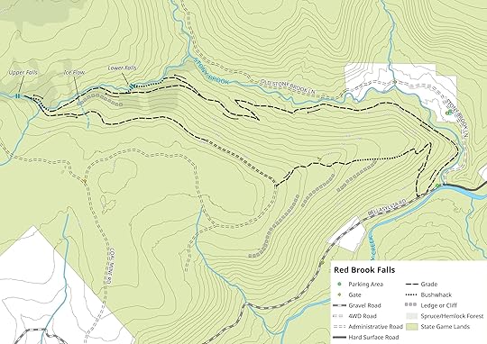
Click map for a detailed geo-referenced PDF. Map courtesy of Ben Van Riper.
Red Brook is a gem in SGL 57. It features a rugged gorge with two waterfalls, cascades, slides, large boulders, and cliffs. The forests in the gorge are diverse and beautiful with spruce, hemlock, birch and maple. The rare Canadian yew clings to the tops of cliffs and boulders. Moss and ferns cover the giant boulders. The gorge conveys the feeling of being in a place much further north.
This diversity should not be a complete surprise, as Red Brook originates from Coalbed Swamp, a spruce boreal wetland that is one of the most diverse places in the Endless Mountains. The swamp is home to many rare plants and animals.
This hike is spectacular, and unique in that the vast majority of it follows old grades or trails; there is little true bushwhacking. No trails are marked or signed. The first half of the hike is far more scenic than the last half, but this route does make for a very nice loop offering great diversity. Ben joined me on this hike.
We parked at a small parking area near Stony Brook and walked up Windy Valley Road (SR 3001) (labeled Bellasylvia Road on map) for about 300 feet and turned right onto an obvious grade. This grade offered views of Stony Brook below. The grade turned left with a massive boulder below on the right in a grove of hemlocks. Here, we followed a much narrower grade just further upslope. This narrow grade was tricky to navigate with the snow and ice as it crossed a steep slope, but it was enjoyable with all the ledges. The narrow grade descended and joined a wider grade, on which we turned left.
This grade gradually climbed. Stony Brook was below to the right; the grade kept its distance but the creek could be both seen and heard. We crossed a variety of seep springs and small runoff streams. The hardwood forest was scenic with many large trees. The grade climbed and reached a juncture, where we turned left. After a short distance we turned right onto another wide grade as it continued through a beautiful hardwood forest. We then spied another grade to the right; it was narrower and had trees growing in it, but it was obvious to see. We followed it. This grade descended into the gorge of Red Brook with spruce trees. It was a scenic hike. This grade ended at Red Brook.
Now our short bushwhack began and it was easy, we just followed Red Brook upstream. This creek has flood damage and there were many large boulders and cascades. We soon reached the bottom of the first falls- Lower Red Brook Falls. This falls is about 20-25 feet tall, has two drops with deep pools, and is very beautiful. We climbed above the falls into a scenic hemlock forest. Small falls and slides adorned Red Brook. We climbed to the same wide grade we had previously been on before turning right down to Red Brook.
This grade was a true pleasure to hike. There was spruce, moss, giant boulders, hemlocks, and views of beautiful Red Brook. Soon ledges loomed to our left with ice flows and seasonal falls. We passed the site of an old cabin. We continued up the obvious grade until it crossed Red Brook, which we also crossed. Continuing upstream we soon reached Upper Red Brook Falls, another gem. This is a 20 foot falls surrounded by an impressive semi-circular grotto and superb ice flows. Red Brook is awesome.
We turned around, headed down Red Brook for the second half of the hike. While it is not as scenic as Red Brook, it does make for a nice loop. If you do not want to hike the loop, just return the way you came along Stony and Red Brooks.
We followed the grade as it gradually ascended the plateau. These forests may be logged in the future. The grade joined into a wider forest road that curved to the right. We then turned left onto a newer logging road which descended the ridge in a hardwood forest. (We did go off trail to explore the cliffs to the west, but there were no notable views). We explored some ledges and outcrops to the south of this road. The road then stopped and became a trail. Again, many trees were painted with red marks, indicating this area may be logged. The trail descended the ridge between Stony Brook and Mehoopany Creek, passing ledges and rock outcrops. The trail crossed a newer logging road, marked with a cairn, and continued downslope until it veered into an meadow area and ended right where we began the hike along Windy Valley Road.
We really enjoyed the hike with its diverse forests and scenery. The loop was perfect and Red Brook is such a beautiful place. If you’re an experienced hiker looking for a new place to explore, be sure to take some time to hike Red Brook.
We parked at about 41.466841, -76.161737. This loop is about 5.5 miles long.
View this post on Instagram
Mehoopany Creek at The Rocks, a great swimming hole. SGL 57.
A post shared by Jeff Mitchell-Outdoors Author (@hiking_mitch) on Mar 2, 2019 at 2:09pm PST
View this post on Instagram
Lower Red Brook Falls, about 25 feet tall. SGL 57.
A post shared by Jeff Mitchell-Outdoors Author (@hiking_mitch) on Mar 2, 2019 at 2:16pm PST
View this post on Instagram
Birch and hemlock forest along Red Brook. SGL 57.
A post shared by Jeff Mitchell-Outdoors Author (@hiking_mitch) on Mar 2, 2019 at 2:23pm PST
View this post on Instagram
A post shared by Jeff Mitchell-Outdoors Author (@hiking_mitch) on Mar 2, 2019 at 2:43pm PST
View this post on Instagram
Glacial blue ice at a frozen falls, SGL 57.
A post shared by Jeff Mitchell-Outdoors Author (@hiking_mitch) on Mar 2, 2019 at 2:45pm PST
View this post on Instagram
Upper Red Brook Falls frozen over. This is located in a beautiful grotto with ice flows. SGL 57.
A post shared by Jeff Mitchell-Outdoors Author (@hiking_mitch) on Mar 2, 2019 at 2:52pm PST
View this post on Instagram
A post shared by Jeff Mitchell-Outdoors Author (@hiking_mitch) on Mar 2, 2019 at 3:01pm PST
View this post on Instagram
Hemlock woods in the gorge of Red Brook. SGL 57.
A post shared by Jeff Mitchell-Outdoors Author (@hiking_mitch) on Mar 3, 2019 at 6:22am PST
View this post on Instagram
A post shared by Jeff Mitchell-Outdoors Author (@hiking_mitch) on Mar 3, 2019 at 6:40am PST
View this post on Instagram
Upper Red Brook Falls, set in an impressive semi circular grotto. SGL 57.
A post shared by Jeff Mitchell-Outdoors Author (@hiking_mitch) on Mar 6, 2019 at 8:00pm PST
View this post on Instagram
A post shared by Jeff Mitchell-Outdoors Author (@hiking_mitch) on Mar 6, 2019 at 6:07pm PST
March 7, 2019
The Spirit of Nessmuk-Winter at the Pine Creek Gorge
We drove across vast fields, blindingly white from the snow despite the cloudy skies. The perfectly smooth complexion marked with rows of the shorn stalks of last year’s corn, creating lines of golden dots. The bare trees and veils of snow showers made it seem we were crossing the artic tundra. We reached the parking area with only one other car there; it soon drove away. The parking area was covered in a layer of crunchy snow. A cold breeze drifted through the pines above. A walkway took us between rhododendrons and under hemlock and red pine. Ahead the earth dropped away, leaving a vast gulf masked by the mist of flurries-the Pine Creek Gorge.
The horizons featured veils of ridges that disappeared into nothingness. It was a vast, silent place as the snow drifted down without a sound. The atmosphere was alive with the breeze and shifting clouds, the swarms of snow showers that appeared and then left. Far below was a ribbon of gunmetal, Pine Creek, as it sliced between the snowy flanks of the gorge it has been carving for thousands of years. The snow revealed the lines of bedrock along the walls of the canyon.
The air within the gorge seemed to shift and settle, inflate and then deflate, as if it were breathing. The snow began to close in, slowly consuming more and more of the gorge from the south and west, until it became one with the sky above.
We walked past a sign honoring George Washington Sears, who went by the pen name “Nessmuk”. He wrote about the beauty of Pine Creek and shared stories about the wilderness and the worlds located within it. He didn’t simply view man as an observer of nature, but directly connected to it; that the best life was one lived among the forests and mountains. Nessmuk showed people that this land was far more than logging, mining, or industry; it had another value worth treasuring. And people have ever since. He was truly the John Muir of the north woods. While Muir wrote about the stunning, obvious landscapes of Yosemite and Mt. Rainier, Nessmuk explored hidden glens and coves to discover magic that was so often overlooked.
The Pine Creek Gorge is a place set apart. It is one of the largest, if not the largest, canyons in the eastern United States. Measuring almost 50 miles long, and 1,450 feet deep, few others can compare to it. Once home to logging, railroads, and tanneries, it has now returned to what it always was- a place of stunning natural beauty for generations of people to enjoy. Just as Nessmuk did over one hundred and thirty years ago.
View this post on Instagram
Nessmuk was the John Muir of the north woods. Learn about those who came before.
A post shared by Jeff Mitchell-Outdoors Author (@hiking_mitch) on Mar 3, 2019 at 1:55pm PST
View this post on Instagram
A post shared by Jeff Mitchell-Outdoors Author (@hiking_mitch) on Mar 3, 2019 at 5:23pm PST
View this post on Instagram
Thank you glaciers! Oh, and Teddy Roosevelt used to fish down there. Pine Creek Gorge
A post shared by Jeff Mitchell-Outdoors Author (@hiking_mitch) on Mar 3, 2019 at 5:30pm PST
View this post on Instagram
A post shared by Jeff Mitchell-Outdoors Author (@hiking_mitch) on Mar 3, 2019 at 5:56pm PST
View this post on Instagram
A post shared by Jeff Mitchell-Outdoors Author (@hiking_mitch) on Mar 3, 2019 at 6:04pm PST
View this post on Instagram
A post shared by Jeff Mitchell-Outdoors Author (@hiking_mitch) on Mar 4, 2019 at 3:40pm PST
View this post on Instagram
Misty canyon. Pine Creek Gorge.
A post shared by Jeff Mitchell-Outdoors Author (@hiking_mitch) on Mar 4, 2019 at 8:26pm PST
March 4, 2019
Hiking Windfall Run-SGL 57
I’ve spent years exploring SGL 57, but have spent little time exploring the southern areas of the gamelands near Noxen. This year, I decided to change that. One hike I’ve wanted to do was a loop along Windfall Run. A few weeks ago, I headed out to see what was there. Ben joined me on this hike.
I parked along Wilson Ayers Road, as named on Google Maps. We then followed a logging road to the right as it gradually climbed through a logged area. The road left the logged area and entered the woods. We were able to follow it with some effort. Below us to the right was Windfall Run. The grade stayed above the run, which did not appear to have any waterfalls. The grade gradually climbed up the glen of Windfall Run and we crossed some side streams and springs. Closer to the top, ledges and rocks appeared on the higher slopes, with some spruce. The grade veered to the left and then crossed a small stream; it became a little harder to follow. The grade climbed to the top of the plateau where we turned left, leaving the grade.
We hiked along the edge of the plateau, battling blueberry bushes and some laurel. We soon reached a cliff rim and some partial views. We continued along the top of the cliffs, as a talus field spread below us. We then reached an outcrop with a great view looking down the glen of Windfall Run and out to Montage Mountain, over thirty miles away. Rolling foothills made this a beautiful vista. Below us were more ledges and a possible cave. We headed south, off trail, to a rock bald. We continued south along ledges and cliffs and veered slightly to the southwest. There we came upon a beautiful mini rock maze that was fascinating to walk through. Within the maze was a porcupine den, so we called in the Porcupine Maze, a highlight of the hike.
Our route continued west along the cliffs and then down an old skid trail to Cider Run Road; this route is not recommended as it is too far out the way and required a road walk. A better route is the one shown on the map. Head east along the ridgeline and then descend along the tiers of ledges and cliffs. Pick up a grade or skid trail and descend to the parking area. No trails are marked or blazed. The route on the map above is about 5.2 miles.
This was a surprisingly rewarding hike with a great view, streams, cliffs, rock bald, ledges, and rock maze. There is a lot of great hiking to be found near Noxen.
Park at about 41.396906, -76.123028.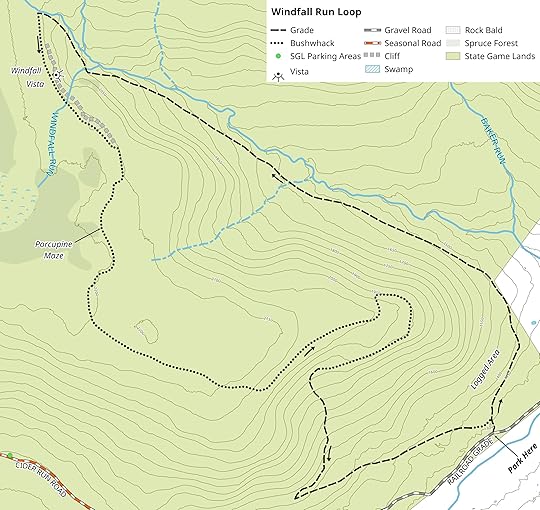
Click map for a detailed geo-referenced PDF. Map courtesy of Ben Van Riper.
View this post on Instagram
A post shared by Jeff Mitchell-Outdoors Author (@hiking_mitch) on Feb 23, 2019 at 11:21am PST
View this post on Instagram
Hazy sun in a spruce forest above Windfall Run, SGL 57.
A post shared by Jeff Mitchell-Outdoors Author (@hiking_mitch) on Feb 23, 2019 at 11:25am PST
View this post on Instagram
Porcupine Maze, a unique rock maze with a porcupine den. SGL 57.
A post shared by Jeff Mitchell-Outdoors Author (@hiking_mitch) on Feb 23, 2019 at 11:28am PST
View this post on Instagram
A post shared by Jeff Mitchell-Outdoors Author (@hiking_mitch) on Feb 23, 2019 at 11:30am PST
View this post on Instagram
Big ledges above Windfall Run, SGL 57.
A post shared by Jeff Mitchell-Outdoors Author (@hiking_mitch) on Feb 23, 2019 at 11:33am PST
View this post on Instagram
A post shared by Jeff Mitchell-Outdoors Author (@hiking_mitch) on Feb 23, 2019 at 11:36am PST
Jeff Mitchell's Blog

- Jeff Mitchell's profile
- 3 followers

