Backpacking the Green Monster Trail (West Loop)-Tioga State Forest
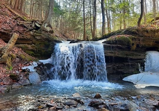
 Goodall Hollow Falls. Near “B” on the map, just below the trail.
Length: My route was about 19 miles.
Parking: Small pull off at about 41.789985, -77.403264
Blazes: Yellow. Some trails are also red, or blue.
Difficulty: This is a challenging trail. Several climbs and descents. No scrambling. Many creek crossings without bridges. Easier than the Black Forest Trail. Similar to the Susquehannock Trail.
Highlights: Good isolation, lots of creeks, a good amount of hiking along or near creeks, cascades and waterfalls, hemlock forests, small meadows, wetlands, large rocks, gorges and glens, Hesselgessel Millstone, Straight Run. (Some features are just off trail)
Trail conditions: I hiked this in March and had no trouble following the route, but it can be more challenging in summer. Blazes can be faded and far apart. Not all trails have signs. Overall, the trails were in good shape and the route was followable. Some areas are wet or mucky. Bring a map and know how to read it. There are turns you need to keep an eye out for. There are many unbridged stream crossings, some are sizeable and will be very dangerous in high water.
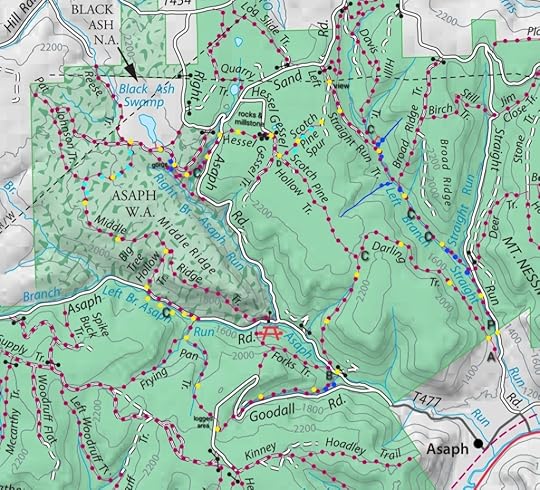
Direction of description: Clockwise from P on map.
Camping: This loop has little established camping, but there are places where camping is possible.
Best time to hike: Mid June for amazing mountain laurel blooms. May to June for wildflowers. Mid October for fall colors. Or when the leaves are off the trees for views of the mountains, or to see down to creeks with falls and cascades.
Maintained by: Tyoga Running Club. The Green Monster Trail (GMT) was created for trail running and there is a popular race in the fall (do not hike that weekend). Hiking and backpacking are welcomed.
Description: The GMT has been on my radar for a while and I finally decided to hike it. It is a 30ish mile loop with a cross connector along Straight Run. This hike describes the west loop. I never hiked much in the Asaph area, and I was impressed by the beauty of this trail.
From P, hike south, or down, Straight Run Road to the first cabin on the right. Here is A, so marked because there are no trespassing signs and purple paint marks, indicating no trespassing. However, the sign for Darling Trail is there and the blazes weren’t painted over. So I’m guessing the public can access the trail corridor. This is the route of the GMT. Darling Trail ascends on an old grade on nice singletrack. At the top, there is a hemlock grove with potential camping. At a Y, turn left. Descend along a small creek with cascades and cross Asaph Road.
Here is B. Asaph Run is the size of a small river, there is no bridge. You can use the nearby road bridge to avoid this crossing. Climb above a small creek. Just below the trail is a beautiful falls (Goodall Hollow Falls) and an upstream cascade. Climb along the deep gorge as the creek cascades below. Go straight cross Goodall Road. At the top, turn right. Cross Goodall Road again and go across a logged area. The trail was in good shape and the open area was a change of scenery.
Descend on Frying Pan Trail into another glen with cascades. There was also a cool birch forest. Reach West Branch Asaph Run at a scenic spot. You need to cross, no bridge. The trail continues up along the run with two more stream crossings. It is scenic, with potential camping. I’m not sure if it is allowed since the road is nearby. If you want to avoid the two additional crossings, hike the road.
Ascend Big Tree Hollow, a good climb, and turn left on the top. A small meadow is to the left. The next section has cruisey terrain under big hardwoods. The trail becomes more wet and mucky near wetlands. Hemlocks become more common. You’ll need to work around some wet areas. Follow an old forest road with more wet areas. Veer right onto another old road. You can hike a short distance off trail to the pond/wetland at Black Ash Swamp under big hemlocks.
Continue on an old road. Look for the yellow blazes where they turn right off the old road. Hike above a deep gorge with falls and enter a corridor of pine and hemlocks, a beautiful section of trail. Cross a creek with potential camping. Hike up to Right Asaph Road and turn left on it. Turn right onto Hesselgessel Trail. Hike through laurel and skirt a meadow. Reach large rock outcrops and even a chasm. The historic millstone is there. The road is in a spruce grove. On the other side of the road is a large meadow wetland. Turn right on the road. Reach D. Turn left on a logging road, and hike for about 200 feet. Then turn left on the yellow trail into the laurel. There are wet areas. Veer left onto a forest road, hike along a logged area and reach a pipeline with a view. Turn right onto the red trail before the pipeline. Descend gradually on an old forest road to Straight Run. There is potential camping along Straight Run, but nothing established.
Straight Run is the highlight of the loop. When I hiked the GMT, I intended to do the whole loop as a figure 8; I planned to hike the cross connector twice. But Straight Run was so scenic, I couldn’t rush it and decided to come back to do the east loop.
There are side stream waterfalls just off trail, and Straight Run has cascades, pools, and waterfalls as well. It is sublime, blissful creekside hiking. And there are a lot of crossings without bridges. I absolutely loved this creek, a true joy. As you head down the creek, reach larger falls (though none are more than 10 feet tall), slides, and an impressive turquoise pool. There’s are falls in a bedrock grotto shortly before the Deer Trail. Reach your car at Straight Run Road.
The most scenic part of the GMT is the Straight Run cross connector, do not miss it.
I was impressed by this loop. It has a great mix of challenge, isolation, scenic and even historic features. I loved all the various creeks and streams, different forest types, deep glens, and gorgeous Straight Run. I will surely hike it again. I think it qualifies as one of the Best Weekend Backpacking Loops in PA.
 Locations are approximate. Basemap from Tioga State Forest.
Legend:
Yellow dots: the route, hiked clockwise from P.
C: potential camping
P: parking
Blue dots: falls, slides, or large cascades. Some are just off trail.
Black dots: Hesselgessel Rocks
Light blue dots: wet, muddy areas
Short red lines: off trail hikes I did
View this post on InstagramA post shared by Jeff Mitchell-Outdoors Author (@hiking_mitch)
View this post on InstagramA post shared by Jeff Mitchell-Outdoors Author (@hiking_mitch)
View this post on InstagramA post shared by Jeff Mitchell-Outdoors Author (@hiking_mitch)
View this post on InstagramA post shared by Jeff Mitchell-Outdoors Author (@hiking_mitch)
Jeff Mitchell's Blog
- Jeff Mitchell's profile
- 3 followers


