
Jeff Mitchell's Blog, page 5
June 6, 2024
Best Weekend Backpacking Loops in Pennsylvania
 Gillespie Point
Pennsylvania has the most extensive system of backpacking trails in the east, and the most loops. These loops are 1.5 to 3 days long and are up to 50 miles in length. Which are the best? Here’s your list!
Eastern Pennsylvania
Pinchot Trail-South Loop. The Pinchot Trail nearly bisects itself, creating a north and south loop. The south loop is particularly scenic with diverse forests, habitats, streams, and Choke Creek Falls. The section along Choke Creek is beautiful with great camping. With mild terrain, this is a great trail for beginning backpackers. About 14 miles.
Loyalsock/Link Loop. A classic loop that should be on every backpacker’s list. Many hikers begin from Worlds End State Park and hike the Loyalsock and Link Trails to form a loop. There are views, waterfalls, hemlock forests, Sones Pond, and the beautiful Loyalsock Creek. This loop also has great camping. It has moderate to challenging terrain. About 17 miles. You can also start at the Mead Road parking area and create a lollipop loop, this would include Dutchmans Falls and the famous Haystack Rapids.
Central Pennsylvania
Old Loggers Path. This perfect loop is loved by backpackers. It has moderate terrain with views, two shelters, waterfalls, big rocks, creeks, fine camping, and good isolation. It’s not too hard, or too easy, it’s just right. Rock Run is gorgeous and a highlight, as are the views from Sullivan Mountain and Sharp Top. There is no bridge across Pleasant Stream, which is dangerous in high water but fine to cross most of the year. About 28 miles.
Black Forest Trail. One of the state’s finest trails, the BFT is known for its challenging terrain and incredible views. Also enjoy meadows, gorges, some waterfalls, rock outcrops, and streamside hiking. There is a good diversity of forest types. The trail dives in and out of gorges, but all the views make it worth it. This is a tough, rewarding trail. It is a must-do. About 42 miles. Another great thing about the BFT is all its side and connector trails, allowing for a variety of loop options.
Slate Run Loop. An excellent loop for those who don’t want to tackle the entire Black Forest Trail. This loop circles the Slate Run Gorge, it is beautiful. Enjoy great views, a few waterfalls, superb camping, and a short side hike to a stunning swimming hole. Terrain is challenging. About 14 miles.
Blackwell/Slate Run Loop (Big Four in the Gorge). An easier alternative to the Black Forest Trail in the Pine Creek Gorge. Follow a network of trails, including the four state forest hiking trails: Black Forest, West Rim, Mid State, and Golden Eagle. This loop has great views and several waterfalls or large cascades. Enjoy scenic creeks and gorges. It’s challenging. About 42 miles.
Tiadaghton Trail/Mid State Trail Loop. Combine the Tiadaghton and Mid State Trails to create a spicy, challenging loop with great views, cascades, and rock formations. A shorter alternative to the Black Forest Trail. This loop is tough. Camping is a bit limited on this loop. About 23 miles.
West Branch/East Fork Loop. Wow, the best loop with moderate terrain that you never knew existed. I loved this loop. The loop for you if you love meadows, beaver dams, ponds, and lodges. So many meadows. Good isolation, streamside hiking, and even a sublime shelter. About 22 miles.
West Branch/Susquehannock Trail Loop. This is the loop to the north of the West Branch/East Fork Loop. While this one is not quite as scenic as the other, it is still worth doing. Enjoy the meadows on West Branch Trail, and the forested gorges and sublime forest walk on the Susquehannock. There is one fine shelter, a dynamite shelter repurposed as a hut, and a view. Some good camping too. Terrain is moderate. About 25 miles.
Allegheny Front Trail. Another gem backpackers love with a great diversity of scenery. Enjoy views, meadows, rhododendron tunnels and great streamside hiking. The cross connector (Shingle Mill and Moss Hanne Trails) has some of the most extensive boardwalks in the state. The cross connector creates two loops on the AFT, an east loop and west loop. Most consider the east to be more scenic, but the west is great too. Terrain is primarily moderate with some challenging sections. Entire loop is 43 miles.
Chuck Keiper Trail-West Loop. The CKT had fallen on hard times, but with help from the Keystone Trails Association and other volunteers, the trail is getting some maintenance love and is coming back to life. The west loop is regarded as more scenic and had been the better maintained. It’s a tough trail with good isolation. Enjoy creek side hiking, a few waterfalls, great camping, beautiful creeks, gorges, and different forest types. About 33 miles.
Quehanna Trail/East Cross Connector Loop. This big loop is about 50 miles and features an array of scenery. Enjoy meadows, cascades, giant boulders, glens, views, creeks, good camping, and isolation. Not to mention elk. Moderate to challenging. Off the ECC, consider including Teaberry, Lincoln Loop, Bridge, and Crawford Vista trails for an even more scenic trek.
Quehanna Wild Area. Wow, what a place. This is a loop making wonderland with a variety of routes to choose from. This the premier place for a choose-your-own-adventure-loop in the state. What are the most scenic trails you’d want to include? Take a look at the following trails: Teaberry, Lincoln Loop, Marion Brooks Loop, Bridge, Crawford Vista, Ralph Seeley, Panther Run, Kunes Camp, Wykoff, Big Spring Draft, Sevinsky, Gore Draft, Foley, Sanders, Red Run.
Here are some loops I’ve done in Quehanna Wild Area:
Red Run/Mosquito Creek LoopPanther Run and Three Runs LoopWestern Pennsylvania
Morrison Trail. A favorite in the Allegheny National Forest, enjoy giant rocks, cascades, great camping, views of the Allegheny Reservoir, fern glades, and mountain laurel blooms. Black Bear Trail is a new side route, it is nice but not a must-do. The loop’s cross connector is particularly beautiful and Morrison Run is gorgeous as well. There is a fee to use the campground along the reservoir, which is popular with boaters in warm weather. Terrain is moderate. About 11 miles. Be sure to see Rimrock Overlook, which is nearby.
Tracy Ridge Hiking Trail System. This is a network of trails near the Allegheny Reservoir, you can easily make a loop exceeding twenty miles. Most people do the 10 mile loop of the Tracy Ridge, Johnnycake, and North Country Trails. However, the North Country Trail from Handsome Lake to Nelse Run is also beautiful, as is the trail along the reservoir to Polly’s Run. Trails can be muddy. The highlight is camping along the reservoir. Terrain is moderate to challenging. Map.
Minister Creek. The most popular trail in the Allegheny National Forest, enjoy giant rock outcrops, cliffs, chasms, and other formations. Be sure to include the gorgeous South Loop. There is one view and great camping. Terrain is moderate. About 7 miles. Map.
Gerard Hiking Trail. This 36 mile loop encircles Oil Creek State Park, featuring waterfalls, some views, and shelters. It winds in and out of hollows with small streams. It passes remnants of the oil industry that existed here, home to the world’s first commercial oil well. This trail is surprisingly rugged and there are cross connectors to shorten the loop. There is a fee to stay at the shelters.
Quebec Run Wild Area. A gem in southwest Pennsylvania, Quebec Run has moderate terrain with scenic streams, great camping, and good isolation. Hike through tunnels of rhododendron and laurel, or open hardwood forests. You can make loops up to 10 miles. Mill Run, Rankin, and Tebolt Trails are among the most scenic.
 Morrison Trail


June 2, 2024
Backpack the Blackwell/Slate Run Loop (or the Big Four in the Gorge Loop)-Pine Creek Gorge
 Pine Creek
Length: About 42 miles
Difficult: This is a challenging loop, but not as difficult as the Black Forest Trail. Expect lots of climbs and descents, with some cruisey sections.
Trail conditions: Overall, pretty good. Some trails were brushy or weedy, but the loop was fairly easy to navigate. Some creeks have no bridges. Most trail junctures have signs.
Highlights: Views, diverse forests, Pine Creek, several waterfalls and cascades, gorges, glens, streams, mountain laurel blooms, good isolation.
Parking: I began at Slate Run and hiked the loop clockwise. Large parking area at 41.471322, -77.502328.
Issues: Some nettle on Vanaimes Trail, and a section of nettle along Long Branch creek. If hiking south/clockwise on the Mid State Trail there was a turn that was easy to miss (see map). This loop has a roadwalk and also follows jeep or forest roads. Established camping is somewhat limited on the loop.
Amenities: Pit toilets, seasonal garbage cans at Blackwell. Small seasonal restaurant in Blackwell. Store and restaurant in Slate Run.
Blazes: Black Forest, West Rim, Mid State and Golden Eagle Trails are orange. Long Branch Trail is red or yellow. Bohen and Dragons Back Trails are yellow.
Maps: Maps of this route can be found at the Tioga and Tiadaghton State Forests websites.
Would I hike again? Absolutely, this was a great loop.
Description: This is an excellent loop in the Pine Creek Gorge you didn’t know existed. It serves as an ideal alternative to the popular Black Forest Trail (BFT). This loop is easier than the BFT, has more waterfalls, cascades, creeks, and water features, but has fewer views (though there are still quite a few views).
I also called it the “Big Four in the Gorge” because this loop connects all four premier state forest hiking trails in the Pine Creek Gorge, the Black Forest, West Rim, Mid State, and Golden Eagle Trails.
From the Slate Run parking area, cross the bridge and pick up (turn right onto) the BFT behind the Hotel Manor. Cross beautiful Slate Run on a bridge and climb the ridge with rock outcrops and pine seedlings. Reach two views at old quarries with more rock outcrops. There is superb dry camping at the second view. Reach the top of the plateau with mountain laurel, pass a spring. Where the BFT goes left, go straight onto the Algerine/Long Branch Trail (LBT). (Point 1 on map).
The LBT is made up of individually named trails and is beautiful; hikers have long loved it. Enjoy more laurel and fern meadows. The terrain is cruisey. Reach Point 2, where the LBT crosses a dirt road. It goes straight across but can be hard to notice. Cross Gamble Run Road. Enjoy diverse forests of pine and spruce, with a small meadow. Follow Vanaimes Trail down Hamilton Hollow, this section is beautiful with cascades and one waterfall. There is some nettle. Reach Cedar Run. A beautiful cascade, grotto and pool is just off the trail on Mine Hole Run.
Follow the LBT into a beautiful glen with another falls. Climb up along Long Branch, this section is more rugged but scenic with cascades and mossy boulders. Nettle becomes an issue but it recedes as you climb. Near the top, hike through pine and spruce forests. Reach the West Rim Trail (WRT) and turn left.
The WRT offers great hiking with meadows and a view. Descend to Bohen Run, turn right onto Bohen Trail. Camping is nearby. Descend into the gorge with cascades. Towering Bohen Run Falls appears below through the trees. Watch for an unsigned blue side trail on the left, it goes down to camping along Pine Creek and rejoins Bohen Trail. Enjoy views of Jerry Run Falls and descend to Blackwell.
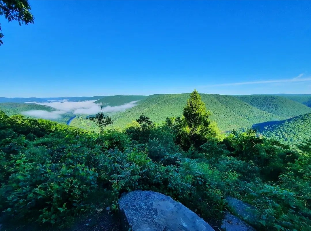
Hike through this scenic village and follow the Mid State Trail (MST) south. Make the big climb up Gillespie Point to see the stunning views. Descend to Brill Hollow and Big Run with cascades. Hike down Big Run, the MST stays above it, but reach an incredible gorge and grotto with falls and slides. Spend some time here. Big Run is so scenic, framed by ledges and cliffs.
Climb over the ridge and down Hoyt Hollow where the MST passes above a 20ish foot falls. Cross Trout Run, a sizeable creek that can be dangerous in high water. Climb and follow grassy forest roads for a few miles. Watch for a turn that’s easy to miss if hiking south. Descend to Brown Fork where there is a good campsite below the trail. Hike to a unique log cabin with a register and climb up a scenic, open stream valley with camping potential. Climb steeply to a nice view. Follow more forest and jeep roads to Barrens Road and parking. Turn right. Follow this lonely road for about three miles.
Reach Point 3. Go straight onto a gated game commission jeep road. Reach Point 4, the gate and sign for the Beulahland Hunting Club, turn right onto a grassy jeep road with one nice view of the fields. Climb the ridge. At the top, another obvious grassy road to the right goes to the impressive Twin Mountain Vista, a short, worthy side trip.
Reach the popular Golden Eagle Trail (GET). The route is to the right, but go left for a quarter mile to the gorgeous Beulahland Vista, another worthy side trip.
Back on the route, follow the GET. Where it leaves the forest road to the left, go straight. This forest road dead ends and the yellow blazes of the Dragons Back Trail appear. Hike along a narrow wooded ridge and enjoy Webber Vista. Descend on switchbacks to PA 414 and the rail trail. Turn right on the rail trail and hike back to Slate Run.
At the southern end of the loop you can also choose alternate routes. Hilborn Trail is very scenic, with three views, but gets very steep at the bottom. You can also follow the GET down Wolf Run and to Ravenshorn, definitely worth it if you have the time, but it will make the route a bit more challenging. Wolf Run has cascades and the view from Ravenshorn is stunning.
Pine Creek Gorge is a special place, enjoy it!
 West part of loop. Orange dots are the route. C is camping or potential camping. Blue dots are waterfalls or larger cascades.
 East part of loop. Camping along Pine Creek accessed by blue side trail. There is a turn on the MST that’s easy to miss if hiking south, or the loop clockwise.
 Point 1. Go right, or straight, on Algerine/Long Branch Trail. Ignore tape and arrow sign, it was for a trail race.
 Point 3. Leave Barrens Road and follow jeep road behind the gate.
 Point 4. The sign and gate is a private hunting club. Follow grassy jeep road to the right.
View this post on InstagramA post shared by Jeff Mitchell-Outdoors Author (@hiking_mitch)
View this post on InstagramA post shared by Jeff Mitchell-Outdoors Author (@hiking_mitch)
View this post on InstagramA post shared by Jeff Mitchell-Outdoors Author (@hiking_mitch)
View this post on InstagramA post shared by Jeff Mitchell-Outdoors Author (@hiking_mitch)
View this post on InstagramA post shared by Jeff Mitchell-Outdoors Author (@hiking_mitch)
View this post on InstagramA post shared by Jeff Mitchell-Outdoors Author (@hiking_mitch)
View this post on InstagramA post shared by Jeff Mitchell-Outdoors Author (@hiking_mitch)
View this post on InstagramA post shared by Jeff Mitchell-Outdoors Author (@hiking_mitch)
View this post on InstagramA post shared by Jeff Mitchell-Outdoors Author (@hiking_mitch)
View this post on InstagramA post shared by Jeff Mitchell-Outdoors Author (@hiking_mitch)
View this post on InstagramA post shared by Jeff Mitchell-Outdoors Author (@hiking_mitch)
View this post on InstagramA post shared by Jeff Mitchell-Outdoors Author (@hiking_mitch)
View this post on InstagramA post shared by Jeff Mitchell-Outdoors Author (@hiking_mitch)
View this post on InstagramA post shared by Jeff Mitchell-Outdoors Author (@hiking_mitch)
May 24, 2024
Waterfalls of Rock Run-SGL 13
 Rock Run, SGL 13
Distance: 4-5 miles one way
Parking: 41.396259, -76.429830. The road was in good shape when I drove it.
Access: closer access may be possible from the gated road at the bottom of the map below, or south of Rock Run. It may be open in hunting season, vehicle with clearance is recommended. As Rock Run is the highlight, this would be the best access.
Highlights: several waterfalls and cascades, isolation, wildflowers.
Trail conditions: This hike follows forest roads and is off trail. There are no marked or blazed trails.
Difficulty: Moderate for off trail hiking. Do not cross Muncy Creek in high water. You should have experience in off trail hiking to do this hike.
Description: There are many Rock Runs in Pennsylvania, and like those other streams, this one is a beauty. SGL 13 is famous for its collection of waterfalls and these are among its most isolated.
From the parking area, I followed the gated roads to the top of Dry Hollow. From there, I bushwhacked down the hollow. There was no thick brush. As I descended, a creek formed and there was a 15ish foot falls. While it was not spectacular in its own right, it was worth seeing since it was along the way. Dry Hollow entered some hemlocks and joined Muncy Creek.
Muncy Creek’s valley was serene and isolated. Old logging or rail roads once followed the creek, the grades are evident but also eroded. I liked the isolated feel of this valley with its groves of hemlocks. I hiked down Muncy Creek and then turned up Rock Run. Rock Run is a small creek, likely dry in summer, but it is a beauty. You’ll soon see why. There are bedrock cascades and falls, the tallest is about 20 feet. Above the tallest falls is a striking mossy bedrock grotto with slides and boulders, a beautiful spot. The beauty continues with broad ledge falls and cascades. You’ll notice an old grade on the west slope of Rock Run that can be used to explore. As you near the top, a logging or forest road is nearby, just to the west. You can take that to the gated road to the south, the best and most convenient access if it opens in hunting season.
I also hiked Lopez Pond Branch and South Branch Rock Run, both were beautiful but had no waterfalls. South Branch Rock Run in particular looked to have wildflowers.
I did this hike in April. There was little thick brush, but I do not know if nettle would be an issue in summer.
Return the way you came. Enjoy the isolated and beautiful place.
 Blue dots are waterfalls. Red is off trail. Brown are forest or logging roads. Locations are approximate, accuracy is not guaranteed. This is not a gps track. Hike at your own risk.
 View this post on InstagramA post shared by Jeff Mitchell-Outdoors Author (@hiking_mitch)
May 20, 2024
Realm of Rocks (and Waterfalls!)-SGL 57
 Pogo Stick Rock
Access: There is parking at 41.413005, -76.164302, however, this road is only open during fall and spring hunting seasons. You can also access via the old Meat Trail from Windy Valley Road, parking is at 41.461493, -76.172896. A trail sign used to be there, it might be gone now. The Meat Trail is faint, and crosses the Mehoopany Creek without a bridge, do not cross in high water. A vehicle with clearance is recommended for these roads.
Highlights: Incredible rock outcrops and formations, mazes, waterfalls, cascades.
Trail conditions: This is an off trail hike, except for the gated game commission roads. Thankfully, on my hikes, the brush was not bad, other than saplings. There is little mountain laurel. The gated road on top of the plateau has wet and boggy areas. Only experienced hikers comfortable with off trail hiking should attempt. Use a navigation device.
Difficulty: Difficult due to rugged terrain and extensive off trail hiking.
Route: the route is up to you, as a result, I did not include mileage. You can expect to hike from 10-20 miles.
Description: I’ve been exploring SGL 57 for almost 20 years and I’m still finding incredible places. This hike is one of the most remarkable I’ve done. I did it over two hikes. The first hike I used the gated road and explored Beech Brook, Birch Brook, and Mehoopany Creek. The second I explored the Realm of Rocks, a cliff escarpment. I gave these places names only to differentiate them. I don’t care if they end up being called something else.
I’ve long wanted to explore the isolated plateau west of Somer Brook. I finally did, and it blew me away,
Beech Brook is a scenic seasonal creek with about four falls and cascades, the tallest is about 15 feet tall. There are falls all the way down to Mehoopany Creek. It is worth exploring if flowing well.
Mehoopany Creek has a very beautiful slide and pool that is a must see.
Birch Brook has many cascades and two notable falls, over twenty feet tall. There are large boulders at the top.
Nearby is the incredibly beautiful and rugged gorge of Somer Brook and the stunning Somer Brook Falls.
The escarpment, or the Realm of Rocks, noted by the black dots on the map, is impressive. Thankfully there is no thick brush, other than saplings, although the terrain is rugged. The route follows the top escarpment of the plateau. If you love rocks, this is the place for you. There is no other place like it in PA, with rock features for miles. There are huge overhangs, chasms, caves, grottos, and boulder cities clothed in moss. I loved all of it. Chameleon Rock is very interesting, with a huge “arm” of rock with the profile of a chameleon. My favorite spot is the Moss Maze, an amazing maze with giant mossy boulders. I also loved Black Birch Maze and Lost World Rocks. Portal Rock is in Lost World Rocks.
As you hike the west side of the escarpment above Mehoopany Creek, the rocks have less moss, but become bigger. High Knob Rocks is named after the former High Knob Trail which went near the top of them. If you look around for it in High Knob Rocks, you might find the most impressive rock formation, Pogo Stick Rock, discovered by Theresa Stuber. This rock formation defies gravity.
Next are Fortress Rocks with huge overhangs and walls.
We also hiked down Boulder Brook with its assortment of falls and cascades. It is a rugged gorge with nonstop cascades, and boulders. The scramble up the south branch was a lot of fun with large boulders and non stop falls.
This is an amazing place, the perfect hike on a cloudy day when the moss becomes so deep and green. PA is a beautiful state, explore it.
 Blue dots are cascades and waterfalls. Black dots are rock formations and features. Meat Trail is very faint and is cut off on this map. Locations are approximate, this is not a gps track. This map is for general directional purposes only. Hike at your own risk. This area is isolated and rugged.
 View this post on InstagramA post shared by Jeff Mitchell-Outdoors Author (@hiking_mitch)
View this post on InstagramA post shared by Jeff Mitchell-Outdoors Author (@hiking_mitch)
View this post on InstagramA post shared by Jeff Mitchell-Outdoors Author (@hiking_mitch)
View this post on InstagramA post shared by Jeff Mitchell-Outdoors Author (@hiking_mitch)
View this post on InstagramA post shared by Jeff Mitchell-Outdoors Author (@hiking_mitch)
View this post on InstagramA post shared by Jeff Mitchell-Outdoors Author (@hiking_mitch)
View this post on InstagramA post shared by Jeff Mitchell-Outdoors Author (@hiking_mitch)
View this post on InstagramA post shared by Jeff Mitchell-Outdoors Author (@hiking_mitch)
View this post on InstagramA post shared by Jeff Mitchell-Outdoors Author (@hiking_mitch)
View this post on InstagramA post shared by Jeff Mitchell-Outdoors Author (@hiking_mitch)
View this post on InstagramA post shared by Jeff Mitchell-Outdoors Author (@hiking_mitch)
View this post on InstagramA post shared by Jeff Mitchell-Outdoors Author (@hiking_mitch)
View this post on InstagramA post shared by Jeff Mitchell-Outdoors Author (@hiking_mitch)
View this post on InstagramA post shared by Jeff Mitchell-Outdoors Author (@hiking_mitch)
View this post on InstagramA post shared by Jeff Mitchell-Outdoors Author (@hiking_mitch)
View this post on InstagramA post shared by Jeff Mitchell-Outdoors Author (@hiking_mitch)
View this post on InstagramA post shared by Jeff Mitchell-Outdoors Author (@hiking_mitch)
View this post on InstagramA post shared by Jeff Mitchell-Outdoors Author (@hiking_mitch)
View this post on InstagramA post shared by Jeff Mitchell-Outdoors Author (@hiking_mitch)
View this post on InstagramA post shared by Jeff Mitchell-Outdoors Author (@hiking_mitch)
View this post on InstagramA post shared by Jeff Mitchell-Outdoors Author (@hiking_mitch)
View this post on InstagramA post shared by Jeff Mitchell-Outdoors Author (@hiking_mitch)
View this post on InstagramA post shared by Jeff Mitchell-Outdoors Author (@hiking_mitch)
View this post on InstagramA post shared by Jeff Mitchell-Outdoors Author (@hiking_mitch)
May 13, 2024
Ketchum Run/Alpine Vista Loop-Loyalsock State Forest
 Lee’s Falls
Length: About 3.5 miles with side hike to Lee’s Falls and the chasm.
Highlights: vistas, waterfalls, gorges, beautiful creek, wildflowers
Parking: Pull off parking at 41.456740, -76.628424. Coal Mine Road is gated in winter.
Trail conditions: Trails are well blazed and easy to follow. The old forest road is obvious, but not blazed. Loyalsock Trail (LT) has yellow/red circular placards. Expect wet areas and steep terrain.
Difficulty: Terrain is rugged. I’d say moderate to difficult.
Direction of travel: For first time visitors, I think counterclockwise is easier to navigate.
Description: This is the perfect dayhike loop in the Loyalsock State Forest. I’m surprised it’s not more popular. Ketchum Run is a gem in the Loyalsock, a place of incredible beauty. However, dayhiking it was a challenge. People either did a 9 mile loop from High Knob Road, or did an out and back from either High Knob or Coal Mine Roads. This loop is perfect, showcasing the highlights of this special place. What more could you want? Two waterfalls, two vistas, beautiful streams and gorges, hemlocks. This hike gives a lot of bang for your buck.
From the pull off parking, with your back to the pull off, go left on Coal Mine Road. Reach a sign for the LT, go left. Reach stunning Alpine Vista with a dry campsite. Follow the edge of the gorge and make a steep descent to equally beautiful Lower Alpine Vista. Snakes are often here in hot weather. This part of the trail is often wet. Continue on a somewhat steep descent to Ketchum Run on the LT (don’t take the ladder bypass trail if you want to see Rode Falls).
Reach Ketchum Run and the beauty of this place is apparent. Rode Falls and its famous ladder comes into view. Climb the ladder and climb away from the creek via switchbacks. At the top, notice a blue blazed trail on the left. That is the route, but I highly recommend a side hike down to Lee’s Falls and the stunning gorge/chasm just upstream of the falls. The gorge/chasm is a few hundred feet long. Turn around before a fern glade.
Follow the blue trail a short distance and reach an old forest road. The old road is not blazed, but is obvious. Cross a meadow. Follow the road on a steady climb back up to Coal Mine Road, at the gate. Turn left on Coal Mine Road back to the car. I’m not sure why the blue trail isn’t marked all the way to Coal Mine Road, hopefully it will be in the future.
 This is the gate as shown on the map.
 From the pull off parking, hike counterclockwise on the LT, to the blue trail, old forest road, to Coal Mine Road. Also be sure to do the side hike down to Lee’s Falls and the gorge/chasm along the LT. Red/yellow on the map is the LT.
 View this post on InstagramA post shared by Jeff Mitchell-Outdoors Author (@hiking_mitch)
View this post on InstagramA post shared by Jeff Mitchell-Outdoors Author (@hiking_mitch)
View this post on InstagramA post shared by Jeff Mitchell-Outdoors Author (@hiking_mitch)
View this post on InstagramA post shared by Jeff Mitchell-Outdoors Author (@hiking_mitch)
May 6, 2024
Backpack the West Branch/East Fork Trail Loop-Susquehannock State Forest
 Meadow views along West Branch Trail
Length: Estimated from maps, I did not track it. The yellow dot route I took is about 22 miles. Using the purple shortcut (recommended) about 19-20 miles.
Difficulty: Moderate. Similar to Old Loggers Path. Biggest climbs/descents are about 600 vertical feet.
Parking: There are two recommended parking areas. I parked at a large pull off on West Branch Road. This is ideal for camping at or near Ford Hollow Shelter and the west end of the loop. It is located at 41.677246, -77.804280 . You will see a sign for the Hopper House Hollow Trail.
The other trailhead is Patterson State Park, located on the west end of the loop. Do not park in the camping area. Park on the east or north side of PA 44. 41.696082, -77.892880
Blazes: Trails are generally blazed well and most junctures have signs. Navigation was easy. West Branch and East Fork Trails are yellow and or red, but mostly red. Susquehannock Trail System (STS) is orange.
Amenities: Pit toilets at Patterson State Park, Ford Hollow Shelter.
Direction of description: Counterclockwise from West Branch Road (Hopper House Hollow Trail).
Highlights: Extensive meadows, beaver dams and ponds, a few views, scenic forests, streams, isolation, gorges, many meadow views, wildlife, birdlife, wildflowers, dark skies for stars.
Trail conditions: Overall, pretty good. You can expect overgrowth in summer. West Branch Trail (WBT) has areas with narrow, eroded sidehill and pickers that thankfully weren’t too thorny. STS is well blazed and maintained. East Fork Trail (EFT) has a better hiking tread than WBT but has more climbing. In some places the trails may be faint, but can be followed.
Navigation issues: I noticed two, both on EFT. If hiking counterclockwise, it is easy to miss the turn onto Switchback Trail and continue straight onto Shinglebolt. There is a trail sign. West of Junction Road, the EFT follows a pipeline swath a short distance from the top of the hill down to the road.
Maintained by: the Susquehannock Trail Club, support these volunteers.
Description: This is the best weekend backpack loop hike you never knew existed. I was absolutely impressed by it and will surely hike it again. The WBT and EFT serve as cross connectors to the STS. By combining all the trails, you can make a truly beautiful loop.
This loop is different than other trails in PA. It feels isolated and has views, just not what you might expect. You will have many meadow views over marshes, beaver ponds and dams. And there’s a lot of beaver ponds and dams. The signature view of the loop is Boone Run Vista, it is just off the EFT and should not be missed. The moderate and cruisey terrain make this a joy to hike.
From the pull off parking area, walk a short ways on West Branch Road and turn left onto WBT. This trail offers so much scenery with meadows, beaver ponds, dams. One pond is pretty large. There are several serene views. I love this trail. Before reaching the STS, cross a small creek with potential camping. Turn left onto the STS.
The STS makes a steady climb up a bucolic forested valley with a small creek. One great thing about this loop is that you are often near creeks, though they can be a trickle or even dry up in summer. Cross PA 44 and hike through Patterson State Park. The STS is level but then descends into a gorge with a seasonal creek. Hike up into Ford Hollow which is usually flowing. Ford Hollow Shelter is a sublime spot, peaceful, isolated, and serene. Elk can be seen or heard here. It is an ideal place to camp.
A steep climb follows up Hockney Hollow. Leave the STS and follow the yellow EFT/Game Refuge Trail. Pass a small meadow with good dry camping. Cross Rock Ridge Road and descend along a logged area with fine views. The EFT down to East Fork Road becomes pure hiking bliss. It follows an old grade, it is cruisey, with superb scenery. The woods are beautiful. My favorite section was the pine forests and the beaver dams and meadows. A gorgeous stretch of trail. You might see potential campsites along the lower portions of the creek, before East Fork Road.
Turn right onto East Fork Road and follow for a half mile, turn left onto the EFT at a sign. Go up another scenic stream valley with more meadows and views. This creek becomes more wooded but the grade offers great hiking. Turn right where the EFT follows Switchback Trail, this turn can be easy to miss. Below along the creek is potential camping. Climb up an open wooded gorge with ferns and wildflowers, this is probably the steepest climb of the loop.
Reach the top and a pipeline swath, follow it to the left down to Junction Road. Time for a side hike, hike the road to the right for 1,000 feet to superb Boone Run Vista, one of the finest in the state forest. It’s a must see. Go back to the EFT.
Now you have a choice. I suggest you take the purple shortcut on the map below. I hiked the EFT on the railroad grade to the STS. It’s nice, don’t get me wrong, the grade was cool and the hiking was mostly level to the STS, but there isn’t much scenery to justify the effort, especially since you must descend and then climb up from the grade on the STS. The purple route does miss Cherry Springs Vista, but Boone Run Vista is a better view anyways.
The final stretch is Hopper Trail/Hopper House Hollow Trail. It’s a nice gem I enjoyed. Begin by crossing small meadows and enter a serene wooded gorge with a seasonal creek. If it’s running, there is some great streamside hiking. There is a small campsite at Cross Trail. The creek becomes larger and West Branch Road comes into view through the trees. This trail remains enjoyable to the end where it delivers you back to the car.
As you hike this loop, you will see many other trails connecting to it. There is a vast network of trails here and many loop options. These trails need more hikers so please explore them.
I loved this loop and I think you will as well.
 East part of loop
 West part of loop
Legend:
Yellow dots: route I took
Purple dots: suggested shortcut route
C: camping or potential campsites
View this post on InstagramA post shared by Jeff Mitchell-Outdoors Author (@hiking_mitch)
View this post on InstagramA post shared by Jeff Mitchell-Outdoors Author (@hiking_mitch)
View this post on InstagramA post shared by Jeff Mitchell-Outdoors Author (@hiking_mitch)
View this post on InstagramA post shared by Jeff Mitchell-Outdoors Author (@hiking_mitch)
View this post on InstagramA post shared by Jeff Mitchell-Outdoors Author (@hiking_mitch)
View this post on InstagramA post shared by Jeff Mitchell-Outdoors Author (@hiking_mitch)
View this post on InstagramA post shared by Jeff Mitchell-Outdoors Author (@hiking_mitch)
View this post on InstagramA post shared by Jeff Mitchell-Outdoors Author (@hiking_mitch)
View this post on InstagramA post shared by Jeff Mitchell-Outdoors Author (@hiking_mitch)
May 5, 2024
Hike to the Waterfalls of Sugar Camp Run- Loyalsock State Forest
 One of the falls on Sugar Camp Run
Length: Roughly a mile, one way.
Difficulty: This is mostly an off trail hike. Terrain can be steep with loose rocks along the creek.
Trail conditions: No trails are marked or signed, part of the hike follows forest roads or grades.
Highlights: A glen with a series of beautiful waterfalls and cascades, spring wildflowers.
Parking: pull off parking at about 41.494963, -76.559255.
Description: The Loyalsock has long been loved by hikers thanks to its beauty. It is well known for its many waterfalls, and this is another of its waterfall gems. This hike is short, but requires you to descend Sugar Camp Run, and then climb back out. It is about a 600 vertical foot descent and climb. I don’t know the official name of this small creek, but I used the name Sugar Camp due to the nearby Sugar Camp Spur.
Follow a gated for road for about 600 feet and then turn right onto another. This will take you to the top of the run, I simply hiked off trail down the creek. It was a bit steep with loose rocks, but the forests were open. There were many trout lillies, trilliums, and dutchmans breeches on my hike.
You will cross several old grades. Come to the first falls, about 8 feet tall. The two branches of the run meet with cascades, just below is an impressive glen of about 4 or 5 falls with hemlocks. It is very beautiful. Posted private land is nearby, but these falls are on state forest. It looks like there are more falls downstream, but are on private land. Do not trespass. From here, retrace your steps.
 Blue dots are cascades and falls. Red is the rugged off trail route I took. Brown are forest roads. Purple may be an easier route on an old grade, I did not take it. This is not a gps track, it is for general directional purposes only. Accuracy not guaranteed. Hike at your own risk.
View this post on InstagramA post shared by Jeff Mitchell-Outdoors Author (@hiking_mitch)
View this post on InstagramA post shared by Jeff Mitchell-Outdoors Author (@hiking_mitch)
April 23, 2024
Hike to Serenity Point and Drip Drop Falls-State Game Lands 57
 Serenity Point
Length: Less than .75 mile, one way
Parking: Game Commission lot at 41.353055, -76.194311. I drove in from Noxen, the road was in decent shape, with occasional potholes.
Difficulty: Challenging. While short, only experienced hikers comfortable with off trail hiking and navigation should attempt this trek. It is almost a 400 foot vertical climb to the view.
Trail conditions: This is an off trail hike. Terrain is rugged and rocky with steep sections going up to the view.
Highlights: Beautiful, isolated view and a seasonal falls. Cliffs, boulders, ledges.
Issues: This area of SGL 57 has recently experienced logging. The forest north of Serenity Point has been logged, the view has not been logged. I noticed trees painted for logging near Wolf Run on this hike, if logged you will need to find an alternate route.
Description: From the parking area, hike west on the road, cross Wolf Run, and look for an unblazed trail in the meadow on the right. Take it. This trail crosses the meadow, enters the woods, and ascends along Wolf Run, but you’ll want to veer left and ascend a ridge up to the plateau. This is the most gradual approach to the view, but it is still rugged and rocky. Woods are open. This area has been painted for future logging so you may have to use another route.
Reach the crest of the plateau, head west. There are large cliffs and ledges. Reach Serenity Point, a name I gave it when I first visited about 8 years ago. This is my favorite view over Bowmans Creek in this area. The view is untouched and the valley is narrower than the view from nearby Coyote Rocks. There are several ridgelines and hollows. In the valley is a dark green forest of pine and hemlock. There is no noise from roads or towns. The only noise is the current of Bowmans Creek, which is kind of loud, like stereo surround sound. As the name states, it is serene. The type of place you can sit for an hour or so. I’d love to see this view in autumn, or in the morning with mist in the valley. It is a good sunset view.
You can continue west along the edge to a small creek and drop down to Drip Drop Falls. This is a seasonal falls, but it is unique in that a falls and view are so close together. Retrace your steps. Enjoy this beautiful spot.
On this hike, I also explore large rocks above Wolf Run, as indicated on the map below.
Serenity Point is located at about 41.356530, -76.200091
My first visit to Serenity Point.
 Drip Drop Falls, old photo
 Red is off trail. Brown is an unblazed trail. Black dots are large rocks, cliffs, ledges. This is not a gps track and is for general directional purposes. Accuracy not guaranteed, hike at your own risk. Dotted red route was the way I went on my first hike, it was steep and rocky.
View this post on InstagramA post shared by Jeff Mitchell-Outdoors Author (@hiking_mitch)
View this post on InstagramA post shared by Jeff Mitchell-Outdoors Author (@hiking_mitch)
April 19, 2024
Hike to the Waterfalls of Rollinson, Wolf, and Lye Runs-State Game Lands 12
 The biggest falls on Rollinson Run
Length: Highly variable depending on the routes you take, can be 9-14 miles.
Trail conditions: other than the game commission road, this hike is off trail. Most of the woods are fairly open, so off trail navigation is pretty easy, but you should have experience doing so. Hike along the creeks to see the waterfalls.
Parking: 41.584131, -76.770659
Highlights: Several waterfalls, views of Schrader Creek, isolation, spring wildflowers.
Terrain: Generally easy to moderate. Must hike along creeks. Rollinson Run is somewhat gorged in and requires hiking, climbing along waterfalls.
Issues: Do not attempt this hike in high water. Off trail navigation required to the waterfalls, you should have experience with that type of navigation.
Description: Schrader Creek Valley is full of natural beauty. It has many waterfalls, views, big rocks, gorges, and historical remnants. This hike is to the hidden gem of Rollinson Run.
Schrader Creek Road is the common artery for this hike. It is a long walk, but there are many views of Schrader Creek, and great opportunities for wildlife, wildflowers, and bird watching. Prepare for sun exposure on hot days. Of course, the best way to travel this road is by bike.
Lye Run is scenic, but not a must see. It has two gorges or glens with cascades and slides. The tallest might be five feet. There are bedrock pools. If you want to explore an out of the way place with nice scenery that few people see, hike along Lye Run.
Rollinson Run is the absolute must see. It’s why you are hiking this. Hike up the creek and soon enter a striking gorge about 700 feet long. It is surrounded by cliffs and ledges. While there are places to climb out, you are somewhat gorged in. There are three or four falls and bedrock slides. The bottom falls is over 20 feet, the middle is about 10, and the top is a huge double slide 40-50 feet tall. It is impressive. At the middle falls is a towering cliff with springs tumbling out of it. Must be incredible when it freezes.
Most people also visit Wolf Run. The woods are open between Rollinson and Wolf, so just walk across the plateau. Wolf has two falls, the bottom one is less than 15, the top one is about 10 feet tall. There are several other smaller slides and cascades.
Return to the road and walk it back to the parking area.
A prior hike to Rollinson Run.
 Black line is Schrader Creek Rd. Blue dots are areas with waterfalls and cascades. This is not a gps track, it is for general directional purposes. Accuracy not guaranteed, hike at your own risk.
View this post on InstagramA post shared by Jeff Mitchell-Outdoors Author (@hiking_mitch)
View this post on InstagramA post shared by Jeff Mitchell-Outdoors Author (@hiking_mitch)
View this post on InstagramA post shared by Jeff Mitchell-Outdoors Author (@hiking_mitch)
View this post on InstagramA post shared by Jeff Mitchell-Outdoors Author (@hiking_mitch)
View this post on InstagramA post shared by Jeff Mitchell-Outdoors Author (@hiking_mitch)
View this post on InstagramA post shared by Jeff Mitchell-Outdoors Author (@hiking_mitch)
View this post on InstagramA post shared by Jeff Mitchell-Outdoors Author (@hiking_mitch)
April 17, 2024
Hike to Yost Run and Kyler Fork Falls- Sproul State Forest
 Kyler Fork Falls
Length: About 1.3 miles one way, about 2 miles to Panther Hollow Falls, one way.
Difficulty: Moderate. It is a gradual 450 foot descent to the falls.
Trail conditions: Good. Chuck Keiper Trail is blazed orange.
Parking: 41.175539, -77.879049
Highlights: Beautiful waterfalls in a gorge with hemlocks and rhododendrons.
Description: This is a gorgeous hike into the gorge of Yost Run to see the two falls of Yost Run and Kyler Fork. From the parking area, follow the Chuck Keiper Trail (CKT) west along a forest road (do not cross PA 144). Pass a cabin and descend along a small creek. Pass another cabin and enter the beautiful gorge. Yost Run Falls soon comes into view, Kyler Fork Falls is just downstream. Each is about 12 feet tall. The setting is very scenic with ledges, falls, cascades, streams, hemlocks and rhododendrons. The CKT is a rugged 50 mile loop and this is one of its most beautiful sections.
You can follow unblazed Kyler Fork Trail above Kyler Fork Falls to see more cascades. A proposed 300+ mile backpacking loop in the PA Wilds is routed to come through here.
You can hike further down the CKT and climb sidehill above the creek. Pass a campsite and reach Panther Hollow Falls, which are only about 6 feet but still scenic. Return the way you came.

View this post on InstagramA post shared by Jeff Mitchell-Outdoors Author (@hiking_mitch)
Jeff Mitchell's Blog

- Jeff Mitchell's profile
- 3 followers

