Jeff Mitchell's Blog, page 4
October 22, 2024
Backpacking the Quehanna West Loop
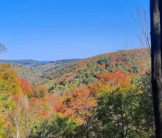 View on Fairview Trail
Length: About 19 miles
Parking: Trailhead is at Parker Dam State Park. 41.193825, -78.506585
Highlights: Meadows, a few views, scenic streams, nice creekside camping, good isolation, hemlock and spruce forests, two small lakes.
Issues: The loop does follow a logging road for a couple miles.
Difficulty: Easy to moderate.
Blazes: Quehanna Trail (QT) is orange, other trails are yellow.
Choose your own route: There are a number of trails you can choose from to lengthen or shorten the loop.
Description: This is an ideal weekend backpacking loop and perfect for those looking for mild terrain. Overall, the terrain is moderate and easy, though there is some climbing and one steep spot near Medix Run. I really enjoyed this loop. It is generally well blazed and maintained. This description is counterclockwise from Parker Dam.
Follow the QT into beech forests, following a stream valley with meadows and old beaver dams. There is good camping past the Spurline Trail. Continue up the valley with more meadows. Veer into the woods with large hardwoods and fern glades. Here the trail seems to follow an old rail grade. As you hike, the forests become more diverse with groves of hemlock and spruce. At Wallace Mine Road, leave the QT and follow the road to the left, on the yellow Quehanna West Cross Connector (QWCC). After .8 mile turn left onto an old forest road and enter more scenic forests. Cross Caledonia Pike into hemlocks. The yellow Shaggers Loop joins, I suggest you include this loop. It encircles the beautiful Shaggers Inn pond with views, pine forests, and meadows. It’s easy and adds some scenery. The Shaggers Loop rejoins the QWCC.
Descend to a stream with nice camping and then hike through a series of meadows. Climb gradually to a road and continue straight onto a gated forest road. The road is wooded and a nice enough walk. Enter more open areas and savannas where there was logging. This is the least scenic part of the loop but I didn’t think it was that bad. There’s a view at a pipeline swath. Watch for where the QWCC leaves the road to the right and crosses a meadow. Enter the woods with some large rocks, blazing is a little infrequent through here but the trail can be followed. Descend and reach a campsite at a nice view, the campsite might be dry, though there is a small spring that bubbles out of the ground. It might be tough to collect water. Next is the steepest part of the loop, follow narrow switchbacks down. Reach Little Medix Road and rejoin the QT, turn left up the road. A nice piped spring is along the road.
Turn right on the QT up a small creek with a small campsite. The creek has some cascades. The trail levels at the top with beautiful fern glades, meadows, and open forests. Descend into a scenic stream valley with one decent campsite, cascades, and a few large boulders. Reach Saunders Road and turn left. Leave the road and hike up Saunders Run with a large campsite off to the right along the creek, ideal for larger groups.
You can continue on the QT up Saunders Run, it is a fine hike, but I did something different on this hike. I took the Fairview Trail. It climbs to the best view on the loop and crosses forests of birch and striped maple. It then follows a gated gravel road. At Tyler Road the blazes end, just go straight on the obvious old road. Enter Parker Dam State Park. The QT joins from the left.
At Parker Lake, leave the road and hike the Laurel Run Trail along the lake. It is scenic with views of the rolling ridges and some large boulders. Parker Dam is such a serene and beautiful state park. Take an obvious path to the left that returns you to the parking area.
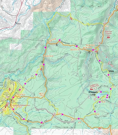 Pink/purple is my route. C are campsites. All locations are approximate.
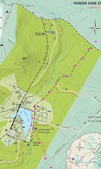 Pink/purple is my route.
View this post on InstagramA post shared by Jeff Mitchell-Outdoors Author (@hiking_mitch)
View this post on InstagramA post shared by Jeff Mitchell-Outdoors Author (@hiking_mitch)
View this post on InstagramA post shared by Jeff Mitchell-Outdoors Author (@hiking_mitch)
View this post on InstagramA post shared by Jeff Mitchell-Outdoors Author (@hiking_mitch)
October 21, 2024
Hike to the Bob Webber Cabin Site-Pine Creek Gorge
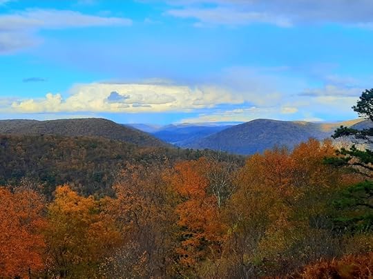 View behind Webber Cabin Site
Length: About 5 miles
Blazes: Gas Line Trail is unblazed (there are old blue blazes), Black Forest Trail (BFT) is orange
Difficulty: Easy to moderate
Highlights: Four fantastic views, site of the Webber cabin, gravesite of Dotty and Bob Webber.
Issues: Gas Line Trail is brushy and can be a little hard to follow east of the cabin site.
Parking: Large lot at forestry buildings. 41.468441, -77.566021
Description: Bob Webber was a PA hiking icon, building, routing, and maintaining many trails in the Pine Creek Gorge, including the famous Golden Eagle and Black Forest Trails. He’d cut trees with an axe and led many hikes. He lived in a cabin with his wife Dotty on the rim of the gorge, a few miles from the nearest road. They lived a simple life that was dedicated to the outdoors and introducing people to the beauty of Pine Creek. Their legacy and spirit live on in the gorge they loved so much.
After the Webbers died, their cabin was moved to the PA Lumber Museum. There is a monument at the cabin site, which I’ve been told is the Webbers’ burial site.
As a result, this hike has the feel of a pilgrimage.
From the parking area, turn right on the road and reach a T. Go straight on the gated Gas Line Trail. This trail is obvious and may have old blue blazes, it follows an old woods road. Reach the BFT and go straight, pass two excellent views. Reach Point A, veer left on Gas Line Trail where the BFT goes right. Gas Line is obvious and descends. Reach a large campsite on the right, to the left is the Webber cabin site with the memorial. You will see old stone paths being reclaimed by vegetation. It is a place to honor a couple who dedicated their lives serving the public. A path goes behind the site to a great view of the gorge. Gillespie Point is in the distance.
The one issue on this hike is the Gas Line Trail just past (east of) the cabin site, it gets brushy and the trail can be a little hard to see, but it’s there. The trail is less established and descends an old grade to the BFT (Point B). Turn right onto the BFT and climb to beautiful Canyon Vista. Reach Point A and retrace your steps, passing the other two vistas.
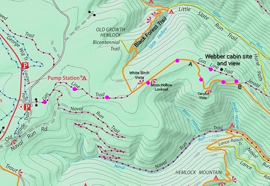 Pink/purple is my route. Gas Line Trail gets brushy east of the cabin site.
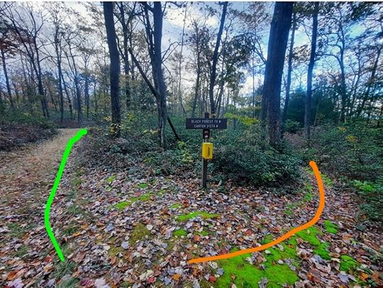 Point A. Gas Line is to the left, BFT to the right.
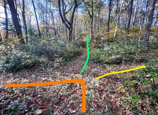 Point B. Gas Line is green, BFT is orange. Jerald Trail is yellow.
View this post on InstagramA post shared by Jeff Mitchell-Outdoors Author (@hiking_mitch)
View this post on InstagramA post shared by Jeff Mitchell-Outdoors Author (@hiking_mitch)
October 10, 2024
Hike to the Bartlett Mountain Balds (And Explore the Wonders of Bartlett Mountain)
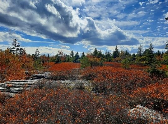 Bartlett Mountain Balds in autumn, a stunning sight
Parking: Large lot near White Brook. 41.496533, -76.131886 Small pull off for about three cars near Stony Brook. 41.466829, -76.161814
Difficulty: This is a challenging and difficult place to explore due to very rugged terrain, no marked trails, overgrown trails, and off trail hiking. You should be an experienced hiker with navigational aids. Some areas, like Catlin Brook or parts of Mary’s Glen and Burgess Brook, are very difficult and demanding. This is an isolated place. Hike with others. Have sufficient food, water, and first aid.
Animals: Bartlett is popular with bear hunters, yet I’ve not seen one on this mountain. Snakes are also common on the rocks and balds, sunning themselves. Do not harm them. There are bobcats, coyotes, deer, and snowshoe hares. The mountain is also known for its diverse populations of songbirds.
Hunting: Be aware of hunting seasons and wear orange. Avoid hiking here at peak hunting times, like deer rifle and bear seasons.
Length: You can expect to hike 12-14 miles to the Bartlett Mountain Balds from the White Brook parking area. Routes obviously vary. You can easily hike twenty miles on Bartlett Mountain.
Highlights: The only spruce bald ecosystem in Pennsylvania. Bartlett Mountain in general is incredibly diverse and scenic with views, waterfalls, miles of giant rocks, caves, chasms, mazes, overhangs, spruce forests, hemlock forests, boreal wetlands, old mines. Most people have no idea scenery like this exists in Pennsylvania.
Description: Bartlett Mountain is a crown jewel of Pennsylvania, no other mountain has its level of diversity and scenery. It is the only location of a spruce bald ecosystem in the state, something found in West Virginia, Adirondacks, and New England. Surprisingly, this was not discovered until 1993. (Source: Wyoming County Natural Areas Inventory, 2001). Bartlett is a vast plateau. Water gathers in swamps and bogs at the top, and then flows down rugged gorges with many waterfalls. I think Bartlett is one of the most outstanding plateaus in the entire Appalachian Mountain range. It is a place of great biodiversity due to its diverse habitats. Bartlett is also known for its extensive giant rocks, with miles of ledges, overhangs, boulder cities, caves, and chasms. These are generally located at the top rim of the plateau.
The mountain is laced with old mining and logging roads, atv trails, and game trails. No trails are marked. Floods over the last twenty years have degraded many old roads and trails. Bartlett is located in State Game Lands 57.
I’ve been exploring Bartlett for over twenty years. After hiking across the country, not to mention hiking the Appalachian and Colorado Trails, it remains one of my favorite places. It has so much diversity, so much beauty, and has something special every season of the year.
This post is not about describing a particular hike or route. It is about giving you the tools to explore Bartlett for yourself- a choose your own route adventure.
Navigating Bartlett Mountain: DOWNLOAD THIS GEO-REFERENCED PDF MAP. It was made by my friend Ben Van Riper. You can upload the map to Avenza or other mapping app to navigate with your phone. Note: the various routes on this map may be faint or even bushwhacks. Others follow old logging roads and atv trails. You must be comfortable hiking off trail. On this map, the Bartlett Mountain Balds are the north half of the pink route. The map is also below:
Bartlett MountainDownloadMore information: This blog has many posts about Bartlett Mountain. Just type in “Bartlett Mountain” or “State Game Lands 57” in the search engine on the blog.
When to hike: Every season is unique on Bartlett. The balds are incredible in early October to see the red blueberry meadows. Fall colors tend to be excellent on the top of Bartlett. June is great for sheep laurel and mountain laurel blooms, which are beautiful. (Keep in mind, the area is known for its snakes). Winter is stark and beautiful, with heavier snow than surrounding areas. All the spruce and hemlock make for great winter hiking.
History: This area was once known as White Rock. In the early 1900s, small towns of tents were erected on Bartlett to harvest huckleberries, which was a cash crop and attracted people from all over. There was music, fights, and storytelling during berry season. Sections of the mountain were burned over every three to four years to encourage the growth of huckleberries. (Forests are slowly reclaiming the balds. For example, in the 1930s, they were significantly larger). This culture of berry picking has been completely lost. Coal was also mined here in the late 1800s. The mines were shallow and relatively small. There were mining camps on the mountain. The coal was soon exhausted. A few old mines remain. Logging arrived in the early 1900s.
Why share this information? Only people can protect special places like Bartlett Mountain and they will do so when they form a relationship with that place. Despite being public land, Bartlett has no official protections to my knowledge. There is no guarantee it won’t ever be drilled, mined, logged, or have wind farms. I’m not opposed to those things, but I feel some places should be protected for future generations. I’m unaware if any of those things are planned for Bartlett, but who knows what the future will bring. Bartlett should remain forever wild. It is a true gem of the Appalachians.
Enjoy this beautiful and special place.
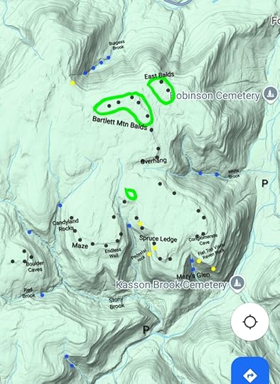 East and central parts of Bartlett Mountain. All locations approximate.
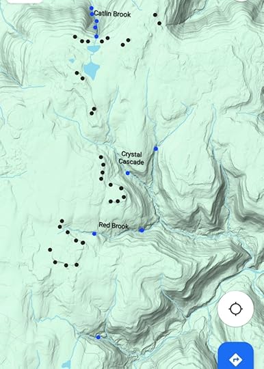 West part of Bartlett Mountain. All locations approximate.
Legend for maps above:
Blue dots: waterfalls or cascades. Black dots: large rocks, ledges, boulders. Yellow dots: vistas. Green circles: bald areas (there are far more). P is parking. Use the link above to the PDF map to navigate.
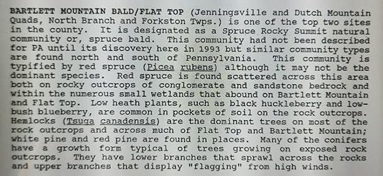 From the Wyoming County Natural Areas Inventory, 2001
View this post on InstagramA post shared by Jeff Mitchell-Outdoors Author (@hiking_mitch)
View this post on InstagramA post shared by Jeff Mitchell-Outdoors Author (@hiking_mitch)
View this post on InstagramA post shared by Jeff Mitchell-Outdoors Author (@hiking_mitch)
View this post on InstagramA post shared by Jeff Mitchell-Outdoors Author (@hiking_mitch)
October 8, 2024
Thomas Darling Preserve-Hike a Boreal Boardwalk
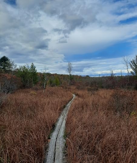 Boardwalk across glacial wetland
Length: Approx. 1.5 miles one way, three miles total.
Difficulty: Easy, no large climbs. There are wet areas, as well as rocks and roots.
Highlights: Woodlands, beaver dam, pond, long boardwalk across a boreal glacial wetland.
Parking: Lot at 41.114682, -75.598562
Blazes: Blue
Description: This is a fairly easy hike to a large glacial wetland. The highlight is a 1,000 foot boardwalk, probably the longest in the Poconos, across a glacial wetland. This enables visitors to see rare plants and flowers.
While there is a loop trail, I prefer to do an out and back to the end of the boardwalk. This avoids crossing private land and allows you to see the boardwalk twice.
From the parking area, follow the first boardwalk and explore forests of pine, spruce, hemlock and birch. Cross a powerline swath and hike along a creek. Reach a beaver dam and pond. Here, the boardwalk begins. Cross meadows of the wetlands with a variety of plants. Reach the end and retrace your steps.
This preserve is owned by the Nature Conservancy. The adjoining preserve owned by the Wildlands Conservancy also has trails.
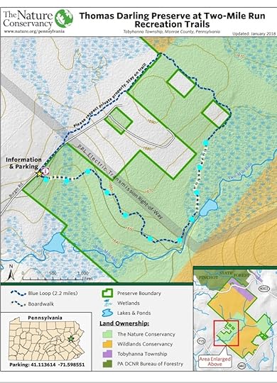 My route was the light blue dots.
View this post on InstagramA post shared by Jeff Mitchell-Outdoors Author (@hiking_mitch)
Hike Fern Ridge Nature Preserve-A Primeval Pocono Forest
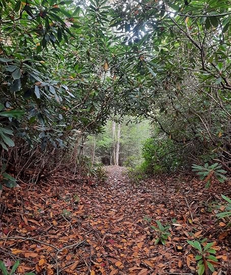 There are extensive rhododendron tunnels at Fern Ridge.
Length: Approx. 5-6 miles total.
Parking: Lot at 41.061451, -75.558757.
Highlights: Rhododendron jungles and tunnels, spruce and hemlock forests, ground pine, small pond, sheep laurel meadow, small streams.
Issues: Must cross PA 115, which can be busy. Can hear traffic from PA 115 and I-80. Trails are brushy in places, blazes can be infrequent. White trail fades out as you hike it. No blazes from PA 115 to pipeline swath. You should have good route finding skills to hike this trail.
When to hike this trail: This hike is a must when the rhododendron blooms, or when the sheep laurel blooms. Autumn. This is also a good winter hike due to all the greenery.
Terrain: Easy, level and rolling. There are wet spots.
Description: This hike explores a Pocono forest as it may have appeared centuries ago. While I wasn’t expecting much on this hike, I actually enjoyed it. From the parking area, cross busy PA 115 and see a sign for the preserve. Follow an old woods road, unblazed. Reach the end of a meadow (Point A) and turn right. Veer left off of grassy forest road into the woods (Point B). Follow a path into the woods as it generally follows an old woods road. The trail is pretty well established. For some reason, there are no blazes. Enjoy hemlocks, pine, spruce, birch and maple. The forest is diverse. Rhododendron surrounds the trail and even forms tunnels. This hike has a lot of rhododendron.
Pass a small pond and reach a pipeline swath, cross it. Now the blazes, and loop, begins. The blazes are pink, sometimes red, and you will also see white. Hike the loop counterclockwise, it is hard to see where the other end of the loop joins, but if you look closely, you will see blazes. The trail is less established, but followable. The forest is scenic with hemlock and pine. You may have to poke around to see blazes, but they are there.
Reach Point C, where the white side trail veers right for a side hike. This trail begins fairly well blazed, but the blazes become infrequent. Cross streams in a scenic hemlock forest. Tunnel through spruce, following the faint trail. Keep an eye out for blazes. The trail basically disappears along game trails with only occasional blazes, reflective plastic on trees. Reach a sheep laurel meadow, the “Barrens” on the map. Here, I turned around. This meadow must be amazing when the laurel blooms.
Back on the loop, the trail is much better blazed, with pink and some red. Enter the rhododendron tunnels, which are very brushy in places. It also becomes a maze, where there doesn’t appear to be an opening, until you look around and find one. Leave the tunnels and mazes into more open woods. Blazes are infrequent. Pick up an old grade or forest road, which you will follow to complete the loop. At the swath, retrace your steps.
This isn’t a hike for everyone. Again, you should be comfortable hiking faint trails. If you enjoy scenic forest hikes, check out Fern Ridge.
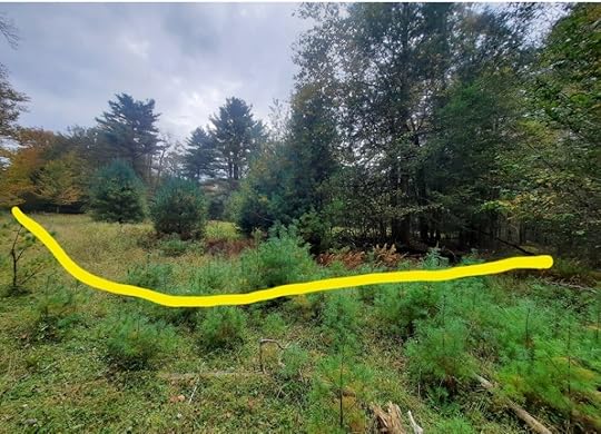 Point A. PA 115 is off to the right. At this meadow, when coming from PA 115, turn right.
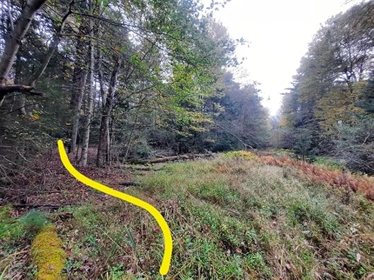 Point B. Don’t follow grassy forest road. Veer left into the woods.
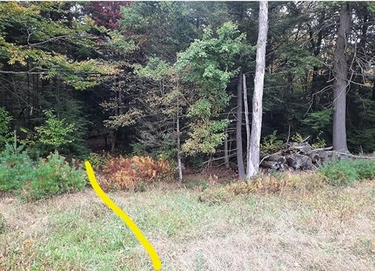 After crossing pipeline swath, go left of timber pile to start the loop
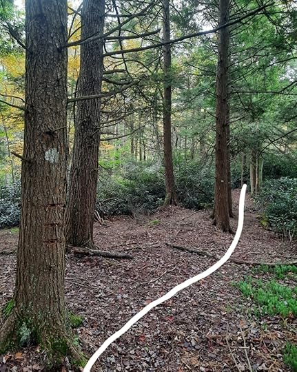 Point C is start of white blazed side trail. Notice tree with three cut marks.
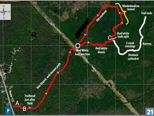 I only hiked white trail to the barrens. Not my map.
View this post on InstagramA post shared by Jeff Mitchell-Outdoors Author (@hiking_mitch)
Gear Review: Desolo Tallac 35 Ultralight Backpack
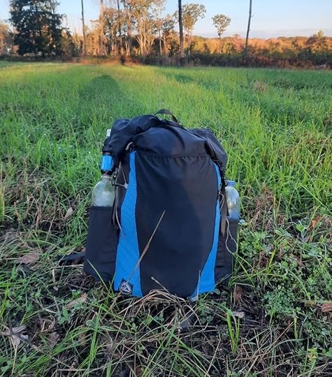 My Tallac 35 pack on the Quehanna Trail
Background: Over the years, my gear has lightened. As a result, I’ve become interested in a frameless backpack, which seemed simpler and more efficient than framed backpacks, not to mention lighter. I was also interested in hiking without a hipbelt, which can cause chafing, abrasions, discomfort, and sweating. Since this was my first frameless backpack, I didn’t want to buy something expensive. I found Desolo Gear and decided to give them a try since their packs appeared to check several of my boxes and the price was very affordable.
Unbiased: I bought my backpack and have received no incentives for this review.
Specs: See manufacturer’s website.
Quality of construction: Overall, very good. The materials are of good quality, with quality stitching. Buckles are larger than more expensive packs, but do the job. I’ve had no issues with tearing or anything falling apart.
Water-resistance: I can’t confirm this as I’ve yet to hike in a heavy rain. The seams are sealed, but I use a compactor or nylofume bag anyways. There is a hole for internal hydration, which compromises water resistance. I’m not really interested in a waterproof bag, I prefer one that is water resistant and sheds most water, this pack appears to be able to do that.
Comfort: Very good, as long as your pack weight is reasonable. I’ve had around 20 lbs in my pack and it was fine, with some adjusting. I like how it hugs and conforms to my back. I think the shoulder straps are sufficiently padded, but some might disagree. I absolutely love hiking without a hipbelt, for the reasons already mentioned. I just feel more free and can move better without the constriction of a hipbelt. I had no unusual shoulder or back soreness from wearing this pack, and when my water and food weight was low, it felt almost weightless.
Volume and weight: I was impressed with both. This is a very light pack, and it seems larger than 35 liters.
Hipbelts: The pack comes with hipbelts, which can be clipped to rings at the bottom of the pack. You have choices between two rings for torso length. The hipbelt pockets are large and well made, and are removable from the belt. I did not find the hipbelts carry any of the weight, however. I don’t use them.
Shoulder straps: Are good, but some think they aren’t long enough. I’m 6 feet and wear a large shirt and the straps are just long enough. This is not a pack for a big person. The straps have daisy chains to attach accessories.
Y Strap: The pack comes with a detachable Y Strap at the top. It works fine, but does not cinch easily, you have to feed it through. This was intentional to lock in any gear on top of the pack. This can be a hassle, but not an issue for me since I usually don’t use the strap on this pack.
Roll top: This is a roll top pack, with velcro, which I don’t mind but don’t think it was necessary. A good thing is that the roll top buckles can clip together at the top, or down along the sides.
Sternum strap: Seems more complex, and has more straps, than necessary. It works fine, but some hikers might swap it out for something simpler.
Mesh and side pockets: Oh, here is where the Tallac shines. The back mesh pocket is huge, stretches, and can swallow gear. The side pockets are large and can hold two one liter bottles, each.
Can you reach water bottles without taking off the pack? I have some trouble doing this. However, I can leave the pack and both shoulder straps on, loosen one strap to lower the pack, and easily reach a bottle. I thought this might annoy me, but I was fine with this process.
Back panel: Like Gossamer Gear packs, there is a mesh back panel for a thin piece of foam. While Gossamer Gear packs have openings in the middle, the Tallac only has an opening at the top. I think this is a better design and prevents the pad from bunching up.
Compression straps: These are thin strings and don’t really compress. Can be easily replaced.
Value: Excellent. This pack is a superb value for the price. I got mine on sale for about $87. The pack is generally around $125.
What would I improve? Longer, slightly wider shoulder straps. Simpler sternum strap. Easier to cinch Y strap. Remove port for internal hydration. Better compression strap design. Angle the side pockets to make it easier to reach a water bottle.
Would I recommend? Yes, this pack is a superb choice for those looking to give a frameless backpack a try. It is very light, comfortable with a lightweight kit, and well made. The huge mesh pocket is perfect. While there is some room for improvement, this pack gets a lot right.
September 6, 2024
Hike the Ketchum Run/Split Rock Loop-Loyalsock State Forest
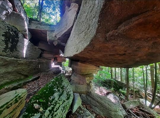 Incredible rock formation
Length: About 4 miles
Difficulty: Moderate
Parking: The space is small, about two cars, three at most. Located at 41.439545, -76.625308
Trail conditions: Overall, pretty good. Some trails are unblazed but established. One section overgrown in summer.
Highlights: Waterfalls, cascades, glens, giant rocks, rock formations, meadows
Issues: This hike follows a variety of trails with turns.
Description: This is a great dayhike with several scenic highlights. It basically uses the Loyalsock Trail (LT) and red blazed bridle trail to make a loop, with side trails. From the parking pull off on High Knob Road, follow the Ketchum Run Trail on an old forest road. Turn left onto the Fern Rock Nature Trail, with yellow blazes and blue fern insignia. The nature trail goes along Ketchum Run with several cascades and small falls. Return to Ketchum Run Trail, turning left.
Reach a T intersection with other marked trails, go straight on an established unblazed trail along Ketchum Run. This is very scenic with two nice sized falls and smaller slides and cascades. Enjoy glens and grottos. This trail should be fairly easy to follow. This trail connects with the LT, turn left onto the LT.
The LT has rolling terrain with nice forests, crosses a small creek, and makes a moderate climb. Reach the giant outcrops at Split Rock, take time to explore the chasms and caves. If facing the rock, go off trail to the left side (or west) for a few hundred feet. There is a 40-50 foot deep cave/chasm and an incredible rock formation.
Continue on the LT on an old forest road until the LT makes a distinct right turn. Continue straight on the old road, it is unblazed but there is a trail. This stretch can be overgrown in summer. Reach a large gravel camping site. Turn left onto Nettle Ridge Rd, a gated forest road and part of the red blazed bridle trail.
This trail was grassy, but not overgrown. Hike along a series of meadows with pine and spruce. Meadows aren’t very common in the Loyalsock so this is a nice treat. Watch where the trail makes a sharp right, it is easy to go straight. Descend and reach a wide old forest road at campsite 711. Walk out to High Knob Road, turn left on the road and return to your car.
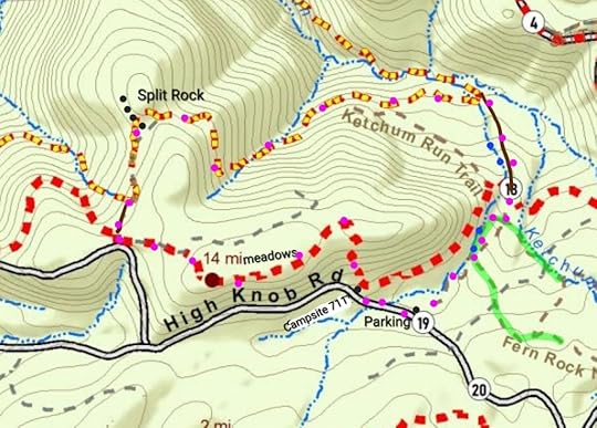 Purple dots are the route. Green is Fern Rock Nature Trail. Red is bridle trail. Red/yellow is LT. Solid brown are unblazed but established trails. Brown dashed are other blazed trails. Blue dots are falls and cascades. Black dots are rocks and rock formations. Locations are approximate.
View this post on InstagramA post shared by Jeff Mitchell-Outdoors Author (@hiking_mitch)
View this post on InstagramA post shared by Jeff Mitchell-Outdoors Author (@hiking_mitch)
View this post on InstagramA post shared by Jeff Mitchell-Outdoors Author (@hiking_mitch)
August 16, 2024
Hike the Tiadaghton/Mid State Trail Loop (One of the Toughest Loops for its Length in the East)
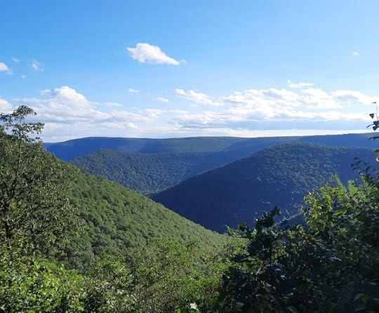 Kline Ridge Vista on the Mid State Trail. Don’t miss this view.
Length: About 23-24 miles
Difficulty: Very challenging. Possibly the most challenging overnight backpack loop in the Mid-Atlantic with over 6,000 feet of elevation gain. (By comparison, the Black Forest Trail at 42 miles has about 8,500 feet of elevation gain). Steep climbs and descents, but no significant rock scrambling.
Highlights: Views, rock outcrops, ledges, and formations, gorges, different forest types, streams, Pine Creek, Little Pine State Park, narrow ridges, many cascades and small falls when the creeks are flowing, old quarries.
Parking: 41.311688, -77.377059. Large lot here.
Direction of travel: I think counterclockwise from the parking area near Waterville is best. The loop is a little easier to navigate, and the terrain starts off more mild.
Blazes: The Tiadaghton Trail (TT) is yellow. Mid State Trail (MST) is orange. The trails are blazed pretty well. You will also see a few old blazes of the TT, red with a white “T”.
Amenities: This loop passes through the Little Pine State Park campground with water, restrooms, picnic tables, and trash receptacles. Happy Acres restaurant and store is also along the trail.
Secret hint: Hike after the Eastern States 100 trail race (usually in August), which follows much of this loop. The section of the loop the race follows would be maintained then with even the nettles being cut back.
When to hike: In mid June for the mountain laurel blooms, after the Eastern States 100 race, mid October for fall colors, or when the leaves are off the trees for non-stop views along narrow ridges and the edges of the canyon.
Volunteers: PA Trail Dogs, Eastern States 100, and the Mid State Trail Association maintain these trails. Thanks to all volunteers.
Would I hike it again? Yes.
What would I do different? Take the purple shortcut on the map (not marked that way on the ground).
Issues: Nettle an issue, some blowdowns, tough terrain, navigation might confuse some in Ramsey or heading clockwise from the parking area near Waterville. Camping is somewhat limited, but there are campsites. They tend to be small. There are rocky areas and loose rocks.
Description: This loop is a beautiful and very challenging. It has a lot of great scenery, but you need to work for it. I really enjoyed it. This loop is a best kept secret for those looking to test themselves and enjoy the beauty of the Pine Creek Gorge. It is not nearly as popular as the Black Forest Trail.
The TT was first established decades ago by a Boy Scout camp (I believe) but was then largely abandoned. Thankfully volunteers have brought this beautiful trail back to life, making this epic loop possible. The old TT blazes can still be seen.
From the parking area, turn right onto PA 44 and cross the bridge. Turn left onto Lower Pine Bottom Road and turn left onto the TT, there is a sign. The trail descends to cabins and then follows an old grade above Pine Creek, it is scenic. Climb switchbacks and enter Bull Run. The trail moves closer to Bull Run with many cascades and small falls; this hike is sublime when it is flowing. Climb a little more steeply and reach the top of the plateau for flat hiking. Jog left on a gravel road and follow an old jeep road down, blazes are a little infrequent through here but the trail is obvious. Follow a narrowing ridge with rock outcrops and views. Continue straight, avoiding trails to the left or right. One view has a 180 degree view. Continue to descend, passing a quarry. Reach the rail trail and turn left, cross Pine Creek, and follow the rail trail to a small parking area.
You are now on the MST. Follow PA 44 to the right for a few hundred feet and cross the road to begin a big climb. Along the way are cascades and rock formations. Reach the top with laurel and level hiking. Dip into a glen with a small creek and climb out. Reach a side trail to a view on the left, don’t miss this. It goes to Kline Ridge Vista, the best view on the loop.
Descend to Ramsey Run, a scenic gorge with cascades and tumbling streams. This is also the best camping on the loop. Climb out of the gorge under hemlocks and reach the plateau with more level hiking. Pass a gas pad and descend to a small side creek, cross a road and then Dam Run with a cascade and deep pool in a grotto.
Gradually climb above Little Pine Creek under large pine trees. Reach the state park campground and hike through it. Reach Little Pine Creek Road. Happy Acres restaurant and store is to the left, they even sell ice cream.
Here, I’d take the purple shortcut route. The MST route is very nice, and the rock outcrops are impressive, but the significant effort to climb, only to descend, may not be worth it for some hikers.
If you decide to stay on the MST, climb up a narrow ridge with old quarries and some very cool rock formations. Descend on the Spike Buck Trail into a gorge with a seasonal creek. Cross Boone Run Road and follow the side of the mountain, passing behind cabins with rock outcrops. Descend to Bush Run at a cabin and piped spring. Now climb up Bush Run, it is tough. Hike through an open area with views. The climb gets steeper and rockier, this is the toughest climb on the loop. At the top enjoy a great view. The last climb is done.
Cross Huntley Road and pass through a wet, muddy area. The trail moves close to the edge of the canyon with a cool rock ledge and then a fine view. Begin to descend on an old road and then follow a long series of switchbacks. At the ends of the switchbacks are views, but you have to go off trail for about 20 feet to see them. The switchbacks continue until you reach an old wagon road above the rail trail. Turn left onto the rail trail and follow to your car.
Great job on completing one of the toughest loops in the Mid Atlantic, if not the east.
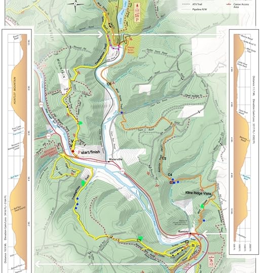 Black dots are rock outcrops or formations. Blue dots are larger cascades, there are many more. Purple dots are a recommended shortcut. V are additional views, just off the switchbacks. Red dot described in photo below. C are campsites and are described below. All locations are approximate.
 Red dot on map. If hiking clockwise, you’d want to turn right onto the mowed path. The TT follows an old wagon road that parallels the rail trail and then climbs.
Camping info:
C1- a small grassy opening at the end of an old forest road. Might fit two tents. Dry.
C2- A mossy area on a ledge, small. Maybe two tents could fit tightly. Dry.
C3- Established fire ring and stone furniture where two creeks meet, but hardly any space for even a tent. Not ideal.
C4- Across the creek from the MST, where the MST switchbacks away from the creek. Fire ring with a stone chair. Might fit three tents, maybe four, little overgrown. Scenic with creeks and ledges. Second best place to camp on the loop.
C5- Best camping on the loop. Below the MST in a hemlock grove along the creek. Looks to fit three tents. Has a fire ring.
C6- Small site along a creek for a tent, maybe two but it’ll be tight. Fire ring. Ground is rooty.
You can also camp at the Little Pine State Park campground, but you must pay.
View this post on InstagramA post shared by Jeff Mitchell-Outdoors Author (@hiking_mitch)
View this post on InstagramA post shared by Jeff Mitchell-Outdoors Author (@hiking_mitch)
View this post on InstagramA post shared by Jeff Mitchell-Outdoors Author (@hiking_mitch)
View this post on InstagramA post shared by Jeff Mitchell-Outdoors Author (@hiking_mitch)
View this post on InstagramA post shared by Jeff Mitchell-Outdoors Author (@hiking_mitch)
View this post on InstagramA post shared by Jeff Mitchell-Outdoors Author (@hiking_mitch)
View this post on InstagramA post shared by Jeff Mitchell-Outdoors Author (@hiking_mitch)
View this post on InstagramA post shared by Jeff Mitchell-Outdoors Author (@hiking_mitch)
July 22, 2024
Backpack the Old Loggers Path-North Loop
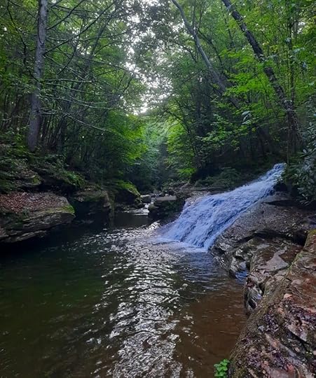 Yellow Dog Run cascades into Rock Run
Length: About 17 miles
Difficulty: Moderate
Terrain: Much of this loop has cruisey or rolling terrain. Steepest sections are in and out of Long Run.
Camping: This loop has lots of great camping and a shelter.
Highlights: Views, creeks, waterfalls, Rock Run, good isolation, good camping, big rocks, great shelter at Doe Run, plenty of cruisey terrain.
Issues: None, really. This loop is pretty perfect. There is an unblazed, but well established, trail. Point A can be easy to miss if hiking clockwise. There are wet areas. Creeks are small, but none have bridges.
Blazes: Old Loggers Path is orange, Cherry Ridge Trail is blue.
Parking: There is a lot at 41.526595, -76.831246, which is where I parked. It is the Cherry Ridge trailhead.
Direction of description: I went clockwise, so that is how it is described. It would be easier to navigate the unblazed trail counterclockwise if you’re unfamiliar with the route.
Description: Wow, what a loop. I absolutely loved this loop, it is ideal as an overnight backpack or long dayhike. It contains almost all of the Old Loggers Path’s (OLP) scenic highlights. While the OLP is a great loop, this shorter loop offers more bang for your buck. I think this loop is one of the most scenic for its length in the Mid Atlantic.
From the parking area, hike the blue Cherry Ridge Trail west (do not follow it around the yellow gate). Enjoy easy terrain with beech and cherry trees. Hemlocks become more common and hike along a small meadow. It is a nice, chill trail. After almost 2 miles, the trail turns left. An unblazed trail goes to the right and crosses a wooden bridge, it goes to Ellenton Road. Stay on the Cherry Ridge Trail.
Climb gradually. After about .5 mile, look for an unblazed trail to the right (Point A). It can be easy to miss going clockwise, so you might want to hike this loop counterclockwise. This unblazed trail is used by trail running races and was well established when I hiked it. It is a pleasant trail, crossing the top of the plateau, gradually descending to an old grade, it passes a meadow and springs, and stays on the grade above Long Run. Then it switchbacks down to Long Run, crossing its several times in quick succession to Point B, where it meets the OLP. The trail juncture at Pont B is obvious, so it may be better to hike this loop counterclockwise.
There are small campsites along Long Run. Now follow the OLP for the rest of the trip, it is blazed orange. Climb steadily out of Long Run, passing several dry campsites. Level on the plateau and hike the cruisey trail through hardwoods. Cross a pipeline swath and descend slightly. A short climb brings you to Sullivan Mountain with its several vistas, ledges, and big rocks. One vista has great dry camping. Tunnel through laurel, enjoy another view to the west, and make a short, steep descent to an old logging road. Hike to Buck Run with camping and large rocks.
Hike the edge of the plateau to Doe Run with a shelter and several campsites. Doe Run has a falls a couple hundred feet downstream. Doe Run Shelter is beautiful. This is a great place to camp. Continue along the edge of the plateau to Rock Run Vista, cross a pipeline, and reach Yellow Dog Road with pull off parking, a larger parking area is up the road. Pass good camping at the headwaters of Yellow Dog Run. Cross a wet area. Descend above Yellow Dog Run, a 20ish foot falls comes into view, it is below the trail but beautiful. Reach a highlight of the loop, the juncture of Yellow Dog and Rock Runs. This place is incredible with bedrock pools, gorges, cascades and slides. Yellow Dog Run cascades into Rock Run. There is excellent camping here.
Hike upstream above Rock Run, enjoying the excellent scenery with cascades and pools. There is more great camping. Rock Run goes out of view as you climb. Pass side creeks and ravines, and a final creek with good camping. Climb gradually to Ellenton Road (or Ellenton Ridge Rd) and the parking area on Krimm Rd.
I will definitely be hiking the loop again.
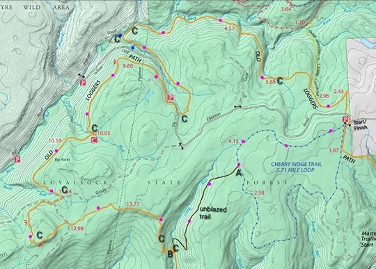 Purple dots are route of the loop. C=camping. Blue dots are waterfalls. Unblazed trail location on map is approximate and is not a gps track.
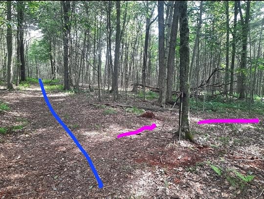 Point A going clockwise. Blue is Cherry Ridge Trail. Purple is the unblazed, established trail.
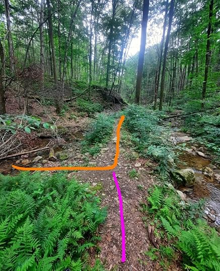 Point B going clockwise. OLP is orange, unblazed trail is purple. It is along Long Run.
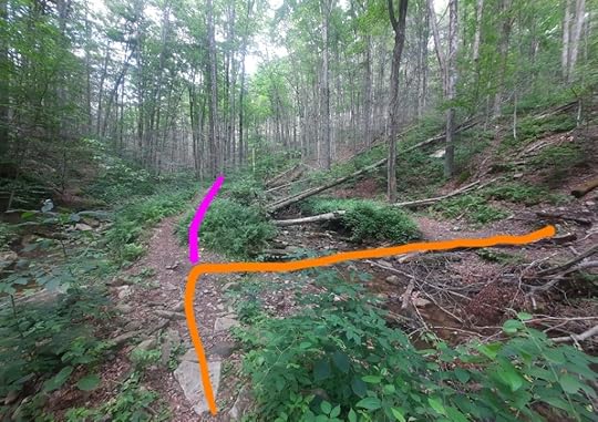 Point B going counterclockwise. This juncture is obvious. OLP is orange, unblazed is purple.
View this post on InstagramA post shared by Jeff Mitchell-Outdoors Author (@hiking_mitch)
View this post on InstagramA post shared by Jeff Mitchell-Outdoors Author (@hiking_mitch)
View this post on InstagramA post shared by Jeff Mitchell-Outdoors Author (@hiking_mitch)
View this post on InstagramA post shared by Jeff Mitchell-Outdoors Author (@hiking_mitch)
View this post on InstagramA post shared by Jeff Mitchell-Outdoors Author (@hiking_mitch)
View this post on InstagramA post shared by Jeff Mitchell-Outdoors Author (@hiking_mitch)
View this post on InstagramA post shared by Jeff Mitchell-Outdoors Author (@hiking_mitch)
View this post on InstagramA post shared by Jeff Mitchell-Outdoors Author (@hiking_mitch)
June 19, 2024
Hike the Crawford Vista Loop-Quehanna Wild Area
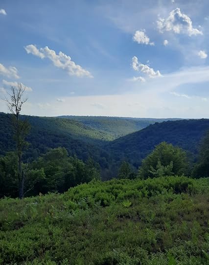 Crawford Vista
Length: 9 miles
Difficulty: Moderate. Terrain tends to be rolling with moderate inclines and descents.
Parking: 41.228522, -78.213365 on Reactor or Lost Run Rd.
Trail conditions: Pretty good. Some areas are brushy but the trails are fairly easy to follow and most junctures have trail signs.
Blazes: Yellow. Red Run Trail is red.
Direction of description: I hiked the loop counterclockwise.
Highlights: Crawford Vista, scenic creeks, huge meadows, ferns, cottongrass blooms in fall, cascades, isolation, good camping, different forest types, chance to see elk.
Description: This loop is an excellent introduction to the Quehanna Wild Area. It can be dayhiked, or it is a great overnight backpack. This loop is scenic with a good amount of diversity.
Cross the road and follow Red Run Trail into a spruce forest. Pass the Meeker Trail (your return route) and reach the Ralph Seeley Trail, turn left on it. This is a scenic trail with hemlocks, large rocks, meadows and a small creek. Cross Meeker Run and turn right onto the East Cross Connector (ECC). Skirt along meadows with large hardwoods and tamaracks. The meadows become larger as you hike. Reach Bridge Trail and turn left. Hike through the woods and then cross a huge meadow with views to the west. Descend to and follow Mosquito Creek with large boulders and rapids. The loop goes left onto Mosquito Creek Trail, but to the right there is a great campsite just down trail at Mosquito Creek.
Climb gradually across fern glades and into a beech forest. Turn right on Crawford Vista Trail and hike along meadows with partial views. Climb more steeply to sublime Crawford Vista as it overlooks the Mosquito Creek gorge. It is isolated and serene. Take a break here. There is a small campsite in the woods behind the view. Although a dry site, it would be a great place to camp.
Meander along the plateau and descend to the ECC at Meeker Run, turn left onto the ECC. Pass large rocks and enter a pine forest, keep an eye out to your right for a small falls and pool off to the right. It is a scenic spot and could be a good place to swim. Pass a great campsite under hemlocks along Meeker Run and turn right onto Meeker Trail. Hike through hemlocks and pines, and then into hardwoods with ferns and small meadows. Reach Red Run Trail and turn right back to the car.
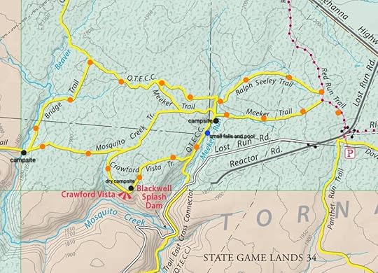 Orange dots are the route. I hiked the loop counterclockwise.
View this post on InstagramA post shared by Jeff Mitchell-Outdoors Author (@hiking_mitch)
View this post on InstagramA post shared by Jeff Mitchell-Outdoors Author (@hiking_mitch)
View this post on InstagramA post shared by Jeff Mitchell-Outdoors Author (@hiking_mitch)
Jeff Mitchell's Blog
- Jeff Mitchell's profile
- 3 followers


