
Jeff Mitchell's Blog, page 9
June 26, 2023
Post Draft Vista-Donut Hole Trail
 Post Draft Vista, Donut Hole Trail
Length: about 1 mile, one way
Blazes: orange
Difficulty: Easy
Trail conditions: trail was well blazed and established
Parking: pull off parking at about 41.339445, -77.611247.
Highlights: great views, mountain laurel, ferns, fall foliage
Description: This short and easy trail leads to a great view of the Sproul State Forest. Located near famous Hyner View, expect to have this view all to yourself. This is an out and back trail along the Donut Hole Trail (DHT). The terrain is easy, with a mild climb. The trail meanders through mountain laurel and across some fern meadows. The forest is mostly hardwoods.
Turn left along a pipeline swath that resembles a mountaintop meadow. Enjoy nonstop views as you hike along the swath. There are also wildflowers. The DHT turns left into the woods, but continue off trail along the swath for about 200 feet to Post Draft Vista. The view is beautiful as it looks into a deep, wooded gorge. There is a campsite. Sunsets must be incredible. Return the way you came.
When we hiked in mid-June, the mountain laurel was in bloom, making for a beautiful hike.
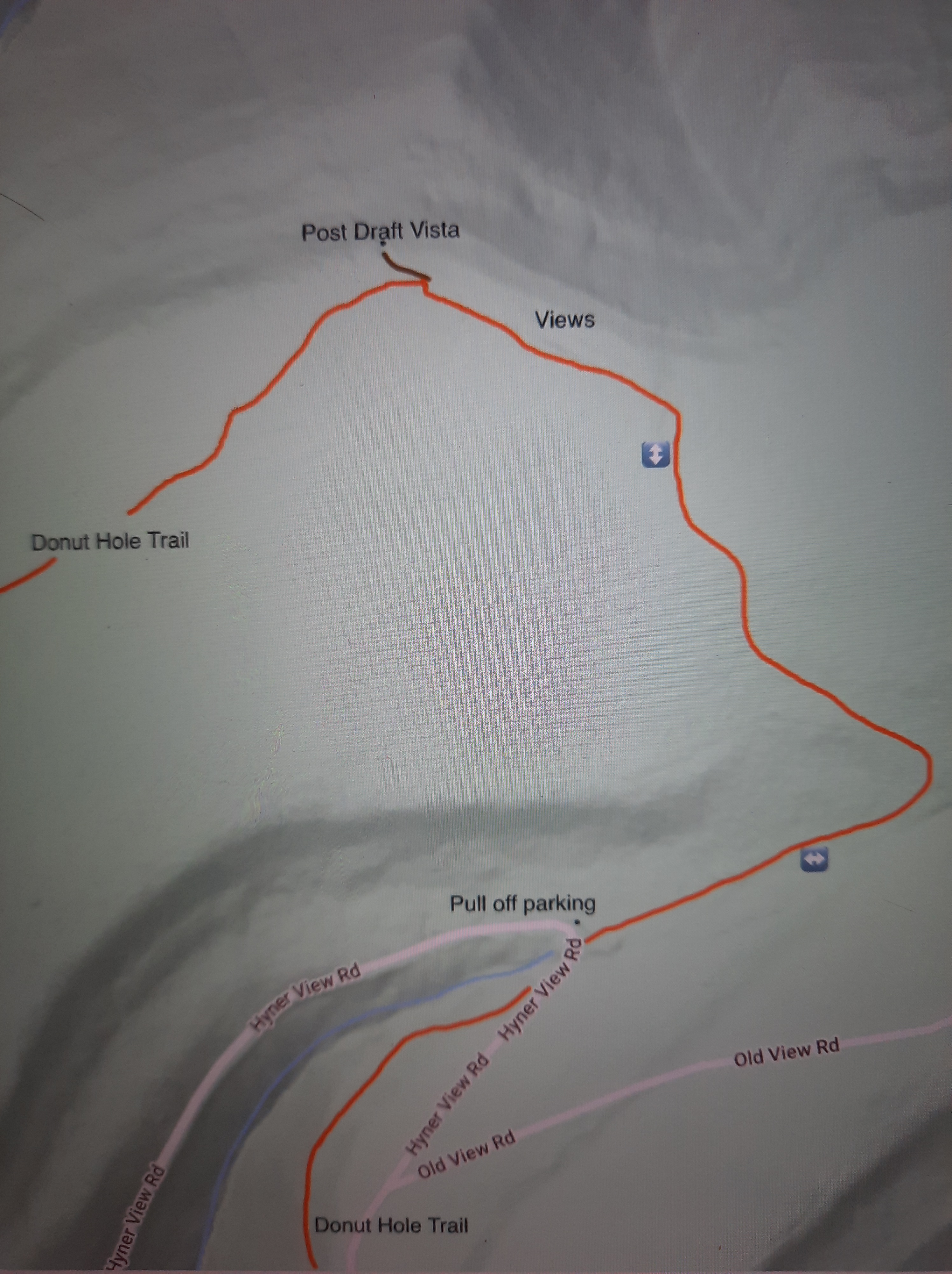 This map is for general directional purposes only, it is not a GPS route. Brown is the short off trail section along the pipeline swath to the view.
 Donut Hole Trail
More photos:
View this post on InstagramA post shared by Jeff Mitchell-Outdoors Author (@hiking_mitch)


June 24, 2023
Hike to Gamble Run Vista-Mid State Trail
 Gamble Run Vista
Length: About 1 mile, one way.
Difficulty: Easy hike
Blazes: Orange. Short side trail to vista is unblazed.
Terrain: level and rolling to the vista
Parking: small lot is at about 41.236678, -77.374679. Old Coudersport Pike was in good shape.
Highlights: Vista, ferns, mountain laurel
Issues: We couldn’t find the second vista lower on the ridge.
Description: This is a short and easy hike on the Mid State Trail to a fine vista overlooking the deep gorge of Gamble Run. From the parking area, the trail travels through fern meadows and into mountain laurel thickets. The trail was well blazed and in good shape. The terrain was level and rolling with a gradual incline.
After about a mile, look for a cairn and a short unblazed trail on the left that goes down to the vista. The view is very nice as it overlooks and the plateau and gorge. Maps show a second view lower on the ridge. We hiked down to see it, but did not locate it. Maybe we didn’t hike far enough, or it is overgrown. We retraced our steps back to the car. The descent looking for the second vista was steep in places.
If you’re looking for a short, easy hike to a fine view, this is the hike for you. If you want a harder hike that’s nearby, hike Gamble Run to the view over Schultz Fork.
 Mid State Trail

More photos:
View this post on InstagramA post shared by Jeff Mitchell-Outdoors Author (@hiking_mitch)
June 18, 2023
Waterfalls of Pond Eddy Creek-SGL 209
 Bluestone Falls
Length: Various depending on where you park. About 6 miles from the bottom parking near the Delaware River. From the top, approx. 10-11 miles.
Difficulty: Moderate-difficult
Trail conditions: no trails are marked or blazed. Hike follows old grades, forest roads, and off trail routes.
Highlights: Waterfalls, cascades, rapids, lake, hemlock forest, remnants of bluestone and flagstone quarries.
Parking: This might be the trickiest thing about this hike. It is best to do this hike from the bottom, or near the Delaware River. However, parking is very limited. You can follow a narrow forest road a few hundred feet to the game commission parking area, which is small and not well developed. The road to it (for about 200 feet) is a little rugged. A vehicle with some clearance is recommended. It is located at approximately 41.428749, -74.824453. There is more parking from the top, but this requires a longer hike. There is a large lot at a gate at 41.400206, -74.830671. However, the road gets rugged going to it, a vehicle with clearance is recommended. There are places to pull off and park before that last lot.
Description: This hike is a hidden wonderland in the Poconos, featuring stunning waterfalls, a mountaintop lake, and extensive old quarries and rock piles when this area was quarried for bluestone and flagstone. This hike really isn’t that hard. The forest is fairly open and the bushwhacking is not difficult. You basically follow the creeks. This description is counterclockwise from the parking at the bottom near the Delaware River.
From the parking area, you will notice an old forest road above on the slope. Take it. It’s not really worth it to hike the creek. The road is obvious and makes a steady climb, cross some small side creeks, including one with an old stone culvert.
This is tricky, but look for an old atv trail or grade to the right, take it (brown route on map). (The more obvious grade you walked in on will be your return route. Yellow route on map.). You know you’re near it when you see a giant rock pile looming on the slope above you. If you can’t find it, don’t worry, just hike through the open woods, keeping Pond Eddy Creek below you on the right. Dip down into a side creek and reach Pond Eddy Creek at a slide and pool. There are many rapids. Go through some blowdowns and continue up the creek, a trail should be noticeable.
Tunnel through some hemlocks and round the bend. Pond Eddy Falls soon comes into view as it tumbles into a pool. It is a beautiful waterfall. It might be around 20-25 feet tall in total. Continue up the creek, you might notice an old atv trail or grade, follow it. There is also a lot of barberry. Look for stone ruins off to your left. After a level area, begin a slight climb as rapids announce themselves on the creek. Cross a sizeable side stream joins from the left, you will return to this spot.
Continue upstream with hemlocks and ledges. Listen for Bluestone Falls off to you right with hemlocks and rock ledges. This is a gorgeous falls and a beautiful setting. Enjoy it. Return to the side stream.
Hike off trail up the side stream, it is best to stay on the east side. Large ledges and cliffs rise on the other side. Enjoy the many cascades and smaller falls. It is rugged and very scenic. While you must hike up rocks, it is not difficult. Notice the Green Chasm, a narrow chasm with moss. It is hard to enter unless the water is low. Climb above the chasm and reach stunning Flagstone Falls, a massive cascading slide. In total, this falls might be close to a hundred feet tall. There are several drops and slides. It is cool to look down the falls as it disappears into the chasm. It is hard to believe this falls is seemingly unknown.
At the top, go through the lowbush blueberry, off trail, and reach an obvious forest road. Turn right to see the mountaintop lake, another incredible place. I saw a golden eagle here. It is like you’ve been transported to Maine or the Adirondacks. Return on the road. Follow the road until you reach an obvious grade to the left, this is your return route and the same grade you hiked in on. The descent is gradual, and the road is washed out in places. Pass large, old quarries and rock piles. Complete the loop and return to your car. This is such a beautiful hike.
If you come in from the south, the only difference is the long walk on the forest road, the same one that goes to the lake. Enjoy this beautiful place.

 Pond Eddy Falls
 Flagstone Falls
 This map is for general directional purposes only, it is not a GPS route. Red is off trail. Brown is a faint trail, ATV trail, or grade.
More photos and videos:
View this post on InstagramA post shared by Jeff Mitchell-Outdoors Author (@hiking_mitch)
View this post on InstagramA post shared by Jeff Mitchell-Outdoors Author (@hiking_mitch)
View this post on InstagramA post shared by Jeff Mitchell-Outdoors Author (@hiking_mitch)
View this post on InstagramA post shared by Jeff Mitchell-Outdoors Author (@hiking_mitch)
View this post on InstagramA post shared by Jeff Mitchell-Outdoors Author (@hiking_mitch)
June 5, 2023
Damascus Forest Trail
 Damascus Forest
Length: Kiosk says it is two miles, but that is an exaggeration. It is over a mile.
Blazes: Yellow
Difficulty: Easy. The trail has some hills.
Trail conditions: Good. The trail is well blazed and established.
Highlights: Diverse forests of pine, hemlock, hardwoods and ferns. Some rock outcrops. Views of wetlands. Meadow. Impressive old growth hemlock and pine forest.
Parking: Large lot is located at 41.635633, -75.062245.
Description: This short, easy loop far exceeded my expectations. I hiked the loop counterclockwise and I suggest you do the same, it saves the most scenic part of the loop for last. From the parking area, hike along a meadow and then enter the woods, passing near some ledges. The trail meanders through hardwoods and then follows a telephone line swath for a short distance. Reenter the woods to the right with pine trees, many pine saplings, and old stone walls. The forest is diverse and scenic.
Drop down a bank that is a little steep and hike along a wetland. There are some views of it. Climb gradually and enjoy the glades of ferns. The trail curves left and enters its most scenic section-a beautiful old growth forest of pine and hemlock. The trees tower to over a hundred feet. I was impressed by this forest. The trees aren’t very wide, but they are tall. It is the highlight of the hike. A wonderful cathedral of trees.
Walk along the meadow and reach the road. Turn left on the road and walk a short distance to the parking area. When we were here, we saw two bears near the parking area.
This enjoyable hike is good for kids or families. I also enjoyed the isolated feel of this forest, with no sounds from traffic or highways.


More photos and video:
View this post on InstagramA post shared by Jeff Mitchell-Outdoors Author (@hiking_mitch)
View this post on InstagramA post shared by Jeff Mitchell-Outdoors Author (@hiking_mitch)
View this post on InstagramA post shared by Jeff Mitchell-Outdoors Author (@hiking_mitch)
May 31, 2023
Backpacking the Allegheny Front Trail-East Loop
 Allegheny Front Trail
Length: 31 miles
Blazes: Yellow. Some side trails are blue. The trail is well blazed and most trail junctures have signs.
Trail conditions: Overall, the trail was in good shape with some blowdowns. Some rhododendron tunnels were brushy. I believe all stream crossings had bridges.
Difficulty: Moderate, overall. This loop has forgiving terrain, however, the section along the vistas is rugged.
Parking: There are several places to park. The most common trailhead is on PA 504: 40.916978, -77.977045. Black Moshannon State Park (call the park office first about parking): 40.914892, -78.058861. Beaver/Shirks Rd: 40.888138, -78.039010.
Highlights: Vistas, meadows, scenic streams, streamside hiking, great campsites, good isolation, Black Moshannon State Park, bogs, wetlands, pine and spruce forests, extensive boardwalks, extensive rhododendron tunnels, mountain laurel, blueberries, beautiful fern meadows, wildflowers.
Issues: sections of the Moss Hanne Trail can be flooded or muddy in high water.
Best camping: Benner Run, Black Moshannon Creek, Smays Run
Direction of description: Counterclockwise from Beaver/Shirks Rd.
Duration: 2-3 days
Maps: available online, or by contacting Moshannon State Forest. (Online map). A Black Moshannon State Park trail map would also be helpful.
Description: The Allegheny Front Trail (AFT) is a 42 mile loop that encircles Black Moshannon State Park. This trail has an “east loop”, comprised of the eastern half of the loop and the cross connector trails, Shingle Mill and Moss Hanne trails. This is an excellent backpacking loop with beautiful, diverse scenery, great camping, and forgiving terrain, for the most part. I think it is one of the best backpacking loops in the Mid Atlantic region.
I began at the parking area at Beaver or Shirks Road. A yellow side trail takes you to the AFT. I hiked counterclockwise. The trail was beautiful with rolling terrain, fern meadows, and hardwoods. Many azaleas were blooming, infusing the air with a sweet scent. Descend to Smays Run with great camping. The hilly nature of the trail continues with fern glades, meadows, and hardwoods. Cross Underwood Road and gradually climb to the trail’s namesake, the Allegheny Front. The front marks the dividing line between the Allegheny Plateau and the Ridge and Valley region.
Descend from the front among boulders and rocks before reaching the first view. The next four miles are by far the most rugged on the loop as the trail goes up and down along the front. You will descend into hollows with small streams and then back up to the plateau. The terrain is rocky. The four vistas are very scenic with the northern one being the most impressive. Reach PA 504 and a popular trailhead for the AFT.
The remainder of the loop is moderate, even easy for fit backpackers. The climbs and descents are gradual with lots of level hiking. Hike across meadows and a grove of spruce. Descend into Rock Run with three places to camp. At times the run is close to the AFT, but most of the time it is not. The Rock Run Trails join the AFT.
Climb away from Rock Run and traverse hilly terrain with fern meadows, blueberry meadows, and hardwood forests. The fall colors through here must be incredible. Descend to Benner Run, a highlight of the loop. Enjoy the pristine, tumbling creek with extensive rhododendron tunnels and hemlocks. There is one excellent place to camp. Benner Run is gorgeous.
But the scenery doesn’t stop. Cross a footbridge on Black Moshannon Creek and hike along this stunning creek with more tunnels, hemlocks, and great camping. Leave the AFT and continue up the creek on the Shingle Mill Trail. The beauty does not stop; this loop has incredible streamside hiking. Cross a gravel road and continue along the creek. The sublime scenery continues. Through here I saw many pink lady slippers.
Reach the state park dam and hike along the lake, taking in the views. This loop as it all, from vistas, to streamside hiking, and hiking along a lake. Cross PA 504. I did a mile roadwalk on the Westside Road and then hiked the boardwalk on the Bog Trail. This trail is excellent as it explores the wetlands with views across the water. Next, turn left onto the Moss Hanne Trail. This yellow trail is unique. It is easy and rolling as it wraps around the wetlands. There are numerous short boardwalks, and two very long ones. It was a joy to hike. You will be able to see the wetlands and maybe some unique plants.
Enter the woods and climb gradually to the AFT; turn left. The AFT is fairly easy, hilly, and passes through small meadows and pine groves. There are several shorter boardwalks. Enjoy more views of the bog, including beaver dams. Cross another boardwalk, cross Julian Pike, and turn right onto the yellow side trail back to the parking area.

 Black Moshannon Creek

More photos:
View this post on InstagramA post shared by Jeff Mitchell-Outdoors Author (@hiking_mitch)
View this post on InstagramA post shared by Jeff Mitchell-Outdoors Author (@hiking_mitch)
View this post on InstagramA post shared by Jeff Mitchell-Outdoors Author (@hiking_mitch)
View this post on InstagramA post shared by Jeff Mitchell-Outdoors Author (@hiking_mitch)
View this post on InstagramA post shared by Jeff Mitchell-Outdoors Author (@hiking_mitch)
View this post on InstagramA post shared by Jeff Mitchell-Outdoors Author (@hiking_mitch)
View this post on InstagramA post shared by Jeff Mitchell-Outdoors Author (@hiking_mitch)
May 26, 2023
Donut Hole/Post Draft Loop-Sproul State Forest
 Post Draft Vista
Length: Approx. 6-7 mile loop
Parking: Pull off parking on Hyner Mountain Road (where this description begins): 41.358681, -77.612945. There is also parking on Old View Road: 41.343858, -77.586890.
Difficulty: moderate to difficult
Highlights: Views, meadows, spring wildflowers, isolation, gorges, small streams, ferns, mountain laurel blooms.
Issues: Nettle in the summer, particularly the bottom half of Post Draft Hollow Trail.
Trail conditions: Overall the trails are in good condition and are blazed well. Some junctures have signs.
Blazes: Donut Hole Trail (DHT) is orange. All other trails are yellow. DHT also has yellow blazes. Cleveland Hollow Trail is not blazed, but is obvious.
Description: This is another great loop near Hyner View State Park. I recommend going clockwise for the more gradual climbs and to save the views towards the end of the hike. From Hyner Mountain Road, follow the DHT up a valley with a creek. The trail is on a forest road. Reach a juncture. Follow the yellow Post Draft Hollow Trail to the left; you will return on the DHT to the right.
The yellow trail makes its way up a scenic wooded gorge with a small creek. Nettle is an annoyance in the bottom half of the gorge, but it becomes less prevalent on the upper half. The climb is gradual and steady. As you near the top, mountain laurel becomes common. The trail levels and reaches Old View Road. There is parking to the left. Cross the road, see a sign for Johnson Run Trail and then make an immediate right onto Ligenza Trail. This trail is enjoyable as it meanders through the woods with meadows and ferns. There is one view at a pipeline clearing.
Reach a gate and stop. The Ligenza Trail goes left, but you’ll want to go right. Walk Old View Road a short distance and turn right onto Cleveland Hollow Trail, there is a sign. This trail follows an old forest road and does not have blazes, but it is obvious. Reach the DHT, turn right. The DHT is a pleasure to hike as it meanders through laurel and woodlands. Reach a pipeline swath and hike it for a few hundred feet with nonstop views. The DHT turns left back in the woods, but go off trail a hundred feet to a stunning campsite and view. This is not to be missed.
The DHT follows an old woods road with rolling terrain. Descend on a ridge and reach more views at a swath. The SOB Hill descends steeply to the right, it is used by trail running races. The DHT follows a more gradual descent on an old road. The SOB Hill rejoins and re-cross the swath with another view. Descend into the gorge with switchbacks. This wooded gorge is scenic with beautiful forests, springs, a small creek, and many wildflowers. Complete the loop and retrace your steps back to the car.
These trails are maintained by the PA Trail Dogs. The Keystone Trails Association also maintains trails in the area.
 Views on the Donut Hole Trail
 This map is not a GPS track, it is for general directional purposes only.
More photos:
View this post on InstagramA post shared by Jeff Mitchell-Outdoors Author (@hiking_mitch)
View this post on Instagramhttps://www.instagram.com/p/Csr9zB9spxr/?utm_source=ig_web_copy_link&igshid=MzRlODBiNWFlZA==A post shared by Jeff Mitchell-Outdoors Author (@hiking_mitch)
View this post on InstagramA post shared by Jeff Mitchell-Outdoors Author (@hiking_mitch)
May 20, 2023
Hike the Hyner View/Huff Run Loop
 Reaching the meadow at Hyner View
Length: Approx. 5.5 mile loop
Difficulty: Difficult
Highlights: Several great views, cascades on Huff Run, meadows, wildflowers, well built trails
Parking: 41.327746, -77.634180 . Don’t be tempted to park at Hyner View, earn the view. Do the climb.
Direction of description: Counterclockwise. I think it is better to climb up to Hyner View then descend.
Issues: Some sections going up to Hyner View are steep. Nettle can be an issue along Huff Run in summer.
Description: This hike needs to be on your list, I enjoyed it very much. It offers both challenge and easy, cruisey sections. And there are views, several more than the famous one at Hyner View. The descent along Huff Run is pure hiking bliss.
Hyner View has become a trail running hotspot. The PA Trail Dogs have done an amazing job building a network of superb trails around Hyner View, creating excellent hiking opportunities. Thier trails are often well built and a pleasure to hike. I hope to explore more of these trails in the future. Try to avoid hiking on their race weekends. Thank you to the PA Trail Dogs for all the work they do.
From the parking area, walk to the end of the road and pick up Cliffhanger. Then turn left onto Carl’s Way, which curves and makes a steady climb up the mountain. There are some views through the trees. Reach a T intersection with Escarpment and the Donut Hole Trail (DHT). Escarpment is blazed yellow and the DHT is orange. The DHT is about a hundred miles long. Here, I suggest a side hike to the right to see excellent views of the river and mountains from ledges. These views are great for a sunset. Return the way you came.
Back on the loop, start the long climb up to Hyner View on the DHT and Escarpment trails. Cross meadows and glades with wildflowers. The DHT appears to separate to the right; it is best to go straight on the yellow trail. The climb steepens and there are more fine views to the south and west.
Reach a meadow area with more views. Enter the woods for another steep push. Break out of the trees and hike up the large meadow that surrounds Hyner Vista. This is pretty dramatic, with views in all directions. Reach Hyner Vista and take pride in your climb; this is by far the best way to experience this famous view.
Turn right on the park road, and then right onto the new Ligenza Trail, blazed yellow. This easy trail explores the woods with ferns. As you near the northern end, the Ligenza Trail follows an old forest road and blazes are few, but the route is obvious. Turn right on Old View Road, a dirt road, hike a short ways, then make a right onto Cleveland Hollow Trail. There is a sign.
Cleveland Hollow Trail is an obvious old woods road; there may be faded yellow blazes. Reach the DHT and turn left. Hike through the woods with laurel and reach Hyner View Road, turn left, follow it a short ways, then turn right on the Huff Run Trail (also the Garby, Paulhamus, and Donut Hole trails).
Descend this yellow trail. This trail is pure hiking bliss. The trail is beautifully built with view of the cascading creek and the deepening gorge. Huff Run has no tall falls, but many small cascades and falls. It is a joy to hike along it. There are spring wildflowers along Huff Run. Cross the run on a footbridge and reach the road. Turn right to the parking area.
Congratulations on making the climb up to Hyner View!
 View from the Escarpment/Donut Hole Trails

 Huff Run
 This map it for general directional purposes, it is not a GPS route.
More photos:
View this post on InstagramA post shared by Jeff Mitchell-Outdoors Author (@hiking_mitch)
View this post on InstagramA post shared by Jeff Mitchell-Outdoors Author (@hiking_mitch)
View this post on InstagramA post shared by Jeff Mitchell-Outdoors Author (@hiking_mitch)
View this post on InstagramA post shared by Jeff Mitchell-Outdoors Author (@hiking_mitch)
View this post on InstagramA post shared by Jeff Mitchell-Outdoors Author (@hiking_mitch)
May 8, 2023
Mid State Trail/Slide Hollow Loop-Tioga State Forest
 Rattler Run Falls
Length: this loop is about three miles. If you add the off trail hiking to Rattler Run Falls and Rattler Rocks, it is about four miles.
Parking: At about 41.610862, -77.304136, it is pull off parking. Rattler Road is usually in good shape.
Highlights: Waterfalls, cascades, ruins, giant rocks, ruins, spring wildflowers
Difficulty: Moderate
Blazes: Mid State Trail (MST) is orange, Slide Hollow Trail is yellow.
Description: This loop explores a hidden area of the Tioga State Forest that is largely overlooked by the crowds that go to the PA Grand Canyon. This loop offers a lot of scenery and diversity, even more so if you add in the off trail hiking. This description is clockwise from the parking on Rattler Road.
If you want to see Rattler Run Falls, just go off trail and hike down Rattler Run. It is best to stay on the south side of the creek. The creek begins to form a gorge with cascades and small falls. You will also pick up an old grade that makes the hiking easier. There are many spring wildflowers. Reach Rattler Run Falls, about twenty feet tall. This scenic falls is set in a rocky grotto. Just downstream is Rattler Run Glen, which is even more scenic with a variety of falls and cascades in a bedrock glen. There is a private property line on the south edge of the glen, so explore from the north side. PA 287 is just below the glen. From here, retrace your steps, or make a shortcut to Rattler Road as the terrain allows.
Now just walk Rattler Road downhill. It is a nice walk. At the bottom, on the right, notice yellow blazes. This is the Slide Hollow Trail. The trail crosses a short section of private property, but hiking is allowed. Stay on the trail. Cross the creek and notice a ten foot falls just upstream set amongst boulders. A gradual climb follows up the glen and it is scenic with many wildflowers and cascades. It is a surprisingly nice trail. Reach the MST at a register. The Slide Hollow Trail was built so backpackers could access resupply in Morris.
Turn right on the MST and cross two branches of Slide Hollow with cascades. Begin a climb that steepens and joins an old grade. The MST levels and then descends to ruins from the coal mining era; these ruins are at the top of an incline plane which was used to haul coal down the mountain.
The MST follows a level grade under hemlocks. If you want to see Rattler Rocks, you’ll need to go off trail to the left a few hundred feet. This rock city is impressive with giant sandstone rocks, chasms, overhangs and caves. It might be the highlight of the hike. Maybe the MST should be rerouted to include it.
Back on the MST, drop down to Rattler Road and the pull off parking area.
The MST is the longest trail in PA and a part of the Great Eastern Trail. For more info on the MST, click here.
 Rattler Rocks
 Rattler Run Glen
 This map is not a GPS route, it is for general directional purposes only.
More photos:
View this post on InstagramA post shared by Jeff Mitchell-Outdoors Author (@hiking_mitch)
View this post on InstagramA post shared by Jeff Mitchell-Outdoors Author (@hiking_mitch)
View this post on InstagramA post shared by Jeff Mitchell-Outdoors Author (@hiking_mitch)
View this post on InstagramA post shared by Jeff Mitchell-Outdoors Author (@hiking_mitch)
View this post on InstagramA post shared by Jeff Mitchell-Outdoors Author (@hiking_mitch)
April 28, 2023
Backpack the Susquehannock/West Branch Trail Loop-Susquehannock State Forest
 Susquehannock Trail
Length: 25 mile loop
Difficulty: Easy to moderate
Parking: There are numerous places to park. I parked at pull off parking on Lyman Run Road, just west of Lyman Run State Park. 41.721934, -77.785968
Direction of description: Counterclockwise from Lyman Run Road
Terrain: Mostly level and rolling with gradual climbs and descents. Terrain south of Lyman Run is the steepest.
Trails maintained by: Susquehannock Trail Club
Trail conditions: The Susquehannock Trail System (STS) is well blazed and in good condition. It has mile markers. The West Branch Trail (WBT) is brushy, has some blowdowns, and faded blazes (these may be corrected soon). The STS is a very smooth trail with few rocks or even roots. The WBT is not as well established, but can be followed.
Blazes: STS is orange. WBT is red and yellow.
Camping: This loop has the Sunken Branch Shelter and a small hut, the Dynamite Shed. Best campsites are at Lyman Run and Palmatier Hollow. There’s also a good campsite on the WBT, in the creek west of Captain Shelton Trail.
Highlights: Isolation, scenic streams, open woodlands, wildflowers, a few beautiful campsites, Sunken Branch Shelter, Dynamite Shed, a few minor views, Peak-A-Boo Vista. I think the most unique thing about this hike are the extensive views over meadows, beaver ponds, and dams along the WBT where you can expect to see a lot of birdlife.
Issues: WBT has brush, faded blazes that can be far apart, and some fallen trees. There are some navigational issues hiking the WBT from west to east. Due to the extensive meadows, expect sun exposure on warm days. The WBT can be followed, but it will be slower going than the STS. I think the scenery of the WBT makes it more than worth it.
Description: This loop is a hidden gem of Pennsylvania backpacking. I thoroughly enjoyed it. The terrain is forgiving, the trail is often smooth, and the forests, creeks, and beaver meadows make for a great experience.
There are views on this trail, but not the kind you might expect. Don’t expect big views like on the Black Forest Trail. Instead you will be treated to views over meadows, ponds and beaver dams. This is great for observing wildlife, seeing flowers, or fall foliage. On the WBT, these views are almost nonstop. You will hike a narrow, isolated valley with views of the ridges and plateaus that rise over you.
I began on Lyman Run Road where there is space for pull off parking. I started there because that puts the best camping at Palmatier Hollow, or the Sunken Branch Shelter, about halfway along the loop. There are many places to start and almost all road crossings have a place to park.
I followed the STS gradually up Jacob Hollow, a scenic valley, with open woods where I could see deep through the trees. There was one campsite, but it was small. I enjoyed hiking along the small creek. Near the top, cross some ATV trails which look like dirt roads. The STS then levels on the plateau with some beautiful forests. A small climb to a ridge offers a view to the south and a side trail leads to a north view. Both views are minor.
The smooth trail continued through the forest, passing cross country ski trails. There is an extensive trail system here besides the STS. I reached the start of the STS loop and a trail register. I then began hiking south on the STS through more woodlands and down another beautiful valley. I hiked in Spring and there were many wildflowers, such a red trillium, squirrel corn, dutchmans breeches and trout lilly.
The STS follows Splash Dam Hollow with several beaver dams, ponds and meadows. It is a taste of what is to come on the WBT. Reach the best camping on the loop at Palmatier Hollow, between miles 80 and 81 on the map. There are two sites under hemlocks. The one downstream is particularly beautiful.
Now climb up another valley along a small stream. Pass a small meadow with some old apple trees, indicating an abandoned homestead. The climb steepens a little and crosses Sunken Branch Road. Descend to Sunken Branch Shelter, a very nice spot that can sleep 4 or 5. There is no water at the shelter, so be sure to bring some with you. The shelter has some amenities like chairs and a table. Sometimes members of the Susquehannock Trail Club bring jugs of water to the shelter, but don’t rely on that.
Descend into a scenic valley with streams and springs. Begin a slight climb into another valley and reach a sign for the WBT and a trail register. Turn left on the WBT and leave the STS. The WBT has yellow and red blazes, although I’m told the trail will be red in the future. You will notice the blazes are spaced far apart, but the trail is followable along an old grade. Soon, the beaver dams and meadows appear. If hiking east on the WBT, there are two navigational issues. About a half mile from the STS, the WBT makes a discreet left turn across a meadow (the Problem Meadow on the map) so keep an eye out for that. The WBT then reached a dirt road (ATV trail) and crosses the creek. Here it is easy to continue on the Beech Hollow Trail, but be sure to make a hard right on the WBT along the creek.
The next three or four miles on the WBT offer some unique hiking. The trail stays on the bank above beaver dams, ponds and meadows, offering extensive views. There a wildflowers and lots of birds. I really enjoyed it. The trail has better blazes and is followable, but it is brushy and there were blowdowns. The valley becomes deeper and more isolated. The beaver dams and ponds become larger, with one covering a few acres. It reminded me of the meadows of Quehanna, except set in a deep valley. I couldn’t help but to stop and look at the scenery. If you love meadows, this is your hike. Despite the very forgiving elevation profile of the WBT, it will take you longer to hike it than you might expect.
The WBT has one good campsite, in a hollow west of the Captain Shelton Trail. As you hike east, the trail becomes more wooded, but there are still meadows and beaver dams. Cross an old concrete bridge with a register and reach West Branch Road. Turn left on the road and walk it for .6 mile. The STS joins, turn left on Sunken Branch Road and then follow the STS right into the woods. Climb gradually to the unique Dynamite House, a historic CCC dynamite shed that was turned into a small hut for hikers. There is some space for a tent.
Continue the climb up the scenic valley. The trail levels across the plateau with forests of hemlock and hardwoods. Cross a dirt road (ATV trail) and continue along the plateau. At the second dirt road, turn left and hike a few hundred feet to Peak-A-Boo Vista, offering a fine view of Lyman Run State Park. Return to the STS and make a steep descent. Pass some springs and reach beautiful Lyman Run. Cross a bridge and some fine campsites. Cross another bridge and reach the end of the loop at Lyman Run Road.
This is a great loop for those who want isolation, great camping, good scenery, and wildlife without killing yourselves. Hopefully more hikers will visit the WBT to help keep that unique and beautiful trail open. The entire STS could use more hikers, hike somewhere different and help support the Susquehannock Trail Club.
 West Branch Trail
 Dynamite House
 Lyman Run
 C are also campsites.
More photos:
View this post on InstagramA post shared by Jeff Mitchell-Outdoors Author (@hiking_mitch)
View this post on InstagramA post shared by Jeff Mitchell-Outdoors Author (@hiking_mitch)
View this post on InstagramA post shared by Jeff Mitchell-Outdoors Author (@hiking_mitch)
View this post on InstagramA post shared by Jeff Mitchell-Outdoors Author (@hiking_mitch)
View this post on InstagramA post shared by Jeff Mitchell-Outdoors Author (@hiking_mitch)
View this post on InstagramA post shared by Jeff Mitchell-Outdoors Author (@hiking_mitch)
View this post on InstagramA post shared by Jeff Mitchell-Outdoors Author (@hiking_mitch)
View this post on InstagramA post shared by Jeff Mitchell-Outdoors Author (@hiking_mitch)
April 11, 2023
Explore the Pinchot Brook Waterfalls-Delaware State Forest
 Slanted Falls, Pinchot Brook
Length: less than a mile
Blazes: this hike is completely off trail, there are no blazes or signs
Parking: 41.356149, -74.850831
Difficulty: Moderate
Highlights: Several beautiful waterfalls, cascades and pools
Description: The Poconos are famous for its many waterfalls. However, the waterfalls on Pinchot Brook appear to be unknown. This is surprising because this creek has a beautiful collection of waterfalls and cascades that are continuous for almost a quarter mile. This hike is in the Delaware State Forest.
From the parking area, head east into the woods. The woods are mostly open with only some low brush. Descend to Pinchot Brook and hike up it. First notice a series of moss covered step cascades, these are the Moss Steps. One highlight of Pinchot Brook is the incredible amount of moss that covers the stream bed. Continue up the creek to Slanted Falls, probably the tallest at about 15 feet. The underlying bedrock has slanted layers. Below the falls is a deep pool.
Above are more cascades, slides and another falls. Moss carpets the bedrock. There are deep pools eroded into the bedrock. This is a very scenic stream. Enjoy the cascading water. At the top is a final falls and then the stream levels off. Here, turn west back to the parking area to complete the loop.
Sawkill and Savantine Falls are nearby, and do not miss Lilly Pond which is just up the road.
 Moss Steps, Pinchot Brook
 Pinchot Brook, Delaware State Forest
 This map is for general directional purposes only, it is not a GPS track. Red is the off trail route.
More photos:
View this post on InstagramA post shared by Jeff Mitchell-Outdoors Author (@hiking_mitch)
View this post on InstagramA post shared by Jeff Mitchell-Outdoors Author (@hiking_mitch)
Jeff Mitchell's Blog

- Jeff Mitchell's profile
- 3 followers

