Jeff Mitchell's Blog, page 12
February 10, 2022
Hike the Fred Woods Trail- Elk State Forest
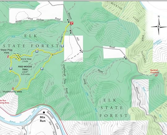
The Fred Woods Trail is one of the most scenic and popular trails in the PA Wilds. It is also unique in being a scenic trail that is also fairly easy, making it ideal for younger hikers. The trail features views and impressive rock outcrops and chasms. The hardest part of the hike might be the drive. Mason Hill Road from Driftwood is a bit rugged and a vehicle with some clearance is recommended. Usually, Mason Hill Road is in good condition once on top of the plateau. On our visit, it was under construction and still a bit rugged. It is also possible to drive from the west, but I do not know the road conditions from that direction.
The Fred Woods Trail is about 4.5 miles long and is named after a forestry worker who died in an accident while performing his duties.
From the parking area, follow the yellow blazed trail into hemlocks and across small streams. The trail follows an old forest road. You will then reach the start of the loop. I like to go left, or clockwise. The trail meanders through the woods, which are open with hardwoods and some ferns. The trail makes it way to the edge of the plateau offering great views when there are no leaves on the trees. The terrain below is very steep. The Bennett Branch of the Sinnemahoning Creek is over a thousand feet below.
Reach the first vista, Huckleberry Vista, from a meadow of lowbush blueberries. This looks up the drainage of the Bennett Branch and is a great view, particularly for sunsets. The Fred Wood Trail continues on the plateau, passing some boulders. The terrain is rolling.
Reach an intersection with the Rock Trail and turn left to the beautiful Water Plug Vista with views of the deep gorge below. The trail climbs gradually and begins to enter the rocks. Enjoy the massive sandstone blocks covered with moss, ferns and lichens. Some support entire forests on top. It is a truly beautiful place. Follow the trail into the highlight, a stunning chasm a few hundred feet long and over thirty feet deep. The Rock Trail makes its way towards Water Plug Vista, but I prefer to enjoy exploring the maze of rocks and return on the main loop of the Fred Woods Trail. The hike again features open hardwoods and fern glades. Complete the loop and retrace your steps back to the parking area.
For the map above, black dots are the massive rocks and boulders.
While in the area, a visit to the Bucktail Overlook is a must see. The vast views are stunning from a huge mountaintop meadow. Look over the huge plateaus and deep canyons.
Parking for the Fred Woods Trail is at about 41.362360, -78.183133. Bucktail Overlook is at 41.349790, -78.153461.
Photos:
https://www.instagram.com/p/CUYXME8vww4/?utm_source=ig_web_copy_linkhttps://www.instagram.com/p/CU02-W0Agj9/?utm_source=ig_web_copy_linkFebruary 4, 2022
A Winter Hike along Sullivan Branch-SGL 13
This area of SGL 13 is famous for its waterfalls, and I’ve visited numerous times. However, I’ve always wanted to see Sullivan Branch in winter with its frozen falls, ice caves, and ice flows. Sullivan Branch is a stream of great beauty that I had seen in every season, but winter.
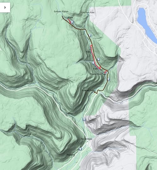
The first issue is access. If there is snow, Sullivan Falls will likely be inaccessible and there will likely be no available parking along Jamison City/Sullivan Falls Road. As a result, we parked near the game commission buildings along Grassy Hollow Road. We hiked up the road and crossed East Branch Fishing Creek on the ice. There is no bridge. Naturally, do not do this hike in high water. Crampons or microspikes will be necessary.
From there we walked up the road to Sullivan Falls and scrambled to the base of the falls. These falls were stunning in winter, and were completely frozen over. Chandeliers of ice grew out of the cliffs surrounding the falls. A transparent sheath had formed over the falls and we could see the water pulsating downwards. And it was so silent.
We returned to the road and then followed an unblazed trail along an old forest grade. We crossed Big Run and made our way up Sullivan Branch. After crossing Pigeon Run, we descended to see the falls. The falls were totally frozen over and an incredible ice cave formed with stunning saw-like icicles. We could hear the water still flowing, and falling, within the columns of ice.
We returned to the trail and hiked up a ways, then we dropped back down to Sullivan Branch and the next big falls. We were able to climb some of the frozen falls. We were treated to falls after falls locked in ice, surrounded by rocky glens with draperies of ice. We took care crossing Sullivan Branch as it has deep bedrock pools in places.
Next was a long bedrock glen surrounded by cliffs. Here we were treated to amazing ice flows and caves that had a blue hue in the bright sun. Hundreds of clear icicles adorned the cave. It was incredible. A tough scramble followed and then we reached another large falls with more ice flows. We were also able to climb this falls.
We returned to the trail and pushed on to the top falls on Sullivan Branch. I was tired and doubting this decision, but I’m glad we did. This top falls had amazing ice flows in a glen of hemlocks. A beautiful sight to see.
From there we retraced our steps back along the unblazed trail and the road to our cars. To my surprise this hike was about eleven miles long. Parking is at 41.315179, -76.348937.
For the map above, red is off trail and brown is an unblazed but established trail. The map is for general directional purposes and does not represent an exact GPS track.
Photos:
View this post on InstagramA post shared by Jeff Mitchell-Outdoors Author (@hiking_mitch)
Other photos:
View this post on InstagramA post shared by Jeff Mitchell-Outdoors Author (@hiking_mitch)
View this post on InstagramA post shared by Jeff Mitchell-Outdoors Author (@hiking_mitch)
View this post on InstagramA post shared by Jeff Mitchell-Outdoors Author (@hiking_mitch)
February 3, 2022
Hike to the Waterfalls of Catlin Brook Gorge-SGL 57
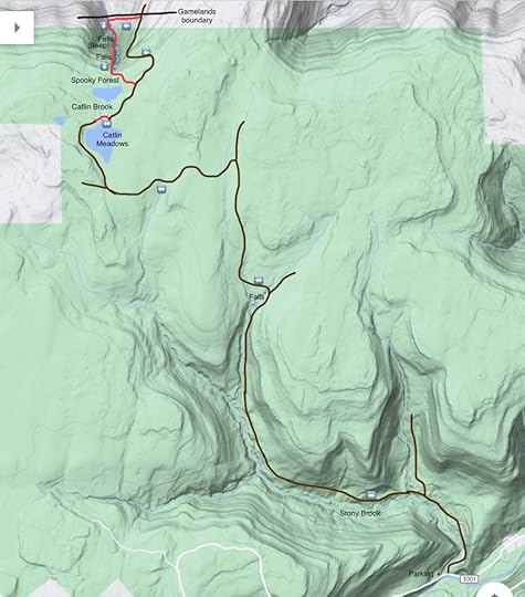
Catlin Brook is as demanding and rugged as it is special. A stream that plummets down a steep gorge with numerous waterfalls and tiers of cliffs. There are no marked trails, there are no signs. Only experienced hikers should attempt this demanding hike. Do not try to hike from Catlin Hollow Road as it is private land; a long hike from Stony Brook is required. It is about 16 miles long.
I described this hike a few years ago. It is worth reading that report. However, this route is different. It is the best and less demanding route as it utilizes an old woods road on the east side of the gorge. This is a far better way to descend into the gorge. Of course, climbing the gorge is very demanding. It is steep, with loose rock, which is probably the greatest risk. There is no requirement for special climbing equipment, but in a few places there is exposure. There is stinging nettle in summer, which recedes as you climb.
The brook can be a trickle in summer or drought, and you don’t want to make this long hike to see dry waterfalls. As a general guide, the USGS gauge for the Loyalsock Creek at Montoursville should be 2.5 to 3 feet for good flow at Catlin Brook. You can also see the brook as it flows under Catlin Brook Road to see how well it is flowing. Do not attempt in high water as the gorge will be very dangerous.
This past summer had a lot of rain so my friends and I decided to tackle Catlin Brook. I think it ranks as one of their most demanding and memorable hikes.
***********************
Wyoming County is home to some world class scenery and one of the gems is Catlin Brook. This is one of the most rugged streams in the state as it plummets off the plateau, creating numerous waterfalls and canyons of rock. However, hiking here has a price; it is a long hike in and it is very challenging. There are no marked trails. Climbing up Catlin Brook should only be attempted by experienced hikers due to the steep terrain and loose rock. However, the incredible scenery more than makes it worthwhile.
We did this hike in the summer and began at Stony Brook, following old logging roads past flood scars. All the creeks were flowing well due to recent rains. The forests were covered in green and ferns carpeted the forest floor. We passed meadows, tumbling streams and small waterfalls. As we hiked further up, deep green red spruce rose through the trees. On this hike we followed a new route, sticking to the old forest roads to Catlin Meadows. This made for an easier hike compared to our previous journeys to Catlin Brook.
The meadows stretched across the plateau, but were too wet to cross. Sometimes, pink and purplish flowers adorn these meadows. The faint grade disappeared. We crossed the swampy outlet and veered right into hemlocks, and soon found the old forest road again as it tunneled through deep hemlocks. Springs and small streams seeped from the moss. We reached the edge of the plateau and began to descend. The old road provided easy passage. We descended as the old road followed some switchbacks. Off to our left was the gorge, and it roared with the sound of falling water. We all looked at each other with both excitement and nervousness. What were we getting ourselves into?
We left the old road and dropped down to the creek along the game lands boundary. The creek was flowing powerfully. Stinging nettle greeted us and there were more than a few curse words directed at these plants. We reached the first falls as it surged through a chasm. Above, a powerful falls plummeted down smooth red bedrock as a side falls joined the scene. We all looked at each other in amazement. Above us the canyon rose with tiers of cliffs and ledges. What was ahead? We would soon find out.
We made our way up the gorge, contorting our bodies to avoid the stinging nettle. Some nettle burned, other plants were harmless. The creek cascaded down over boulders and ledges, and the nettle would move in the breeze created by the falling water.
Off to our left, springs flowed over dark ledges creating translucent draperies of water. We scrambled up the steep terrain. Walking along the creek provided some refuge from the nettle. Up the creek we slowly climbed, sometimes on all fours. The gorge has a lot of loose rock and we had to be careful where we stepped. Some rocks would slide down the creek. Everyone seemed silent, dumbfounded by what they were seeing. We looked at each other and just shook our heads. The gorge is so steep, the earth just seems to fall away into oblivion.
We reached the heart of the gorge, with a wall on the left over a hundred feet tall and a series of incredible waterfalls. Springs plummeted down the wall. In winter, there are incredible ice flows here. We took a break at the base of the falls and soon began to make our way up, climbing along the ledges above the water. We had to be careful, as there was some exposure along the ledges. Above use were more falls, we were surrounded by the roar of water. And then there were more waterfalls. One after the other. The gorge seemed to get even steeper and the falls were often encased in glens of cliffs. The terrain finally began to ease as we neared the top, but we could still see a series of waterfalls through the forest, gowns of white between the trunks of trees. Everyone was amazed.
We scrambled up some mossy boulders and passed the final falls. Then we crossed the “Spooky Forest”, a deep hemlock and pine forest with gnarled, twisted trees. Exhausted, we reached the old forest road and crossed the outlet of the meadows, not caring as our legs sunk into the muck. Our legs and feet were soaked anyways. We made the long hike back down along Stony Brook, reaching our cars as twilight descended along the isolated gorges and valleys of the Mehoopany Creek.
Catlin Brook is an amazing place that we are lucky to have in Wyoming County. Hiking up the gorge should only be attempted by experienced hikers. Do not hike it in high water, and a winter traverse will require ice climbing gear.
For the map above, brown is old forest road or grades, which can be faint in places. Red is off trail. The above map is for general directional purposes and does not represent an exact GPS track.
Parking is at about 41.466889, -76.161620.
Photos and videos:
https://www.instagram.com/p/CRh2USwNLFW/?utm_source=ig_web_copy_linkhttps://www.instagram.com/p/CRff0njtyOj/?utm_source=ig_web_copy_linkhttps://www.instagram.com/p/CReQ-vbNU5D/?utm_source=ig_web_copy_linkhttps://www.instagram.com/p/CReI5KDNzCe/?utm_source=ig_web_copy_linkhttps://www.instagram.com/p/CRclDAytZIV/?utm_source=ig_web_copy_linkFebruary 2, 2022
Hike the Van Scott Nature Reserve-Delaware Highlands Conservancy
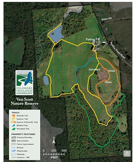
Located near Honesdale, the Van Scott Nature Reserve is a great place to hike with about three miles of intersecting trails featuring great scenery. There is a pond, woodlands, an old cemetery, and extensive fields and meadows. Probably the highlight are the excellent views from the fields. You can see from the Catskills to New Jersey’s High Point.
Park behind the barn at the conservancy’s office. We followed a rather convoluted route. First we hiked down to the pond along the Explorer Trail. The trail went around some fields. Next we hiked the Woodland Trail, which as the name implies, goes into the woods. The forest is mostly open hardwoods with some ledges. Next was the Butterfly Trail, which has the best views of the hike. The views are rather impressive and extensive thanks to the vast fields and meadows. Do not miss hiking to the highest point of the hill for the best views. Fall would bring great colors, as would spring and summer with all the wildflowers.
We also saw an old cemetery along the Explorer Trail. The Bluebird Trail was another fine hike with more views.
The terrain is moderate and hilly in places, but it is never very steep or difficult. The Van Scott Nature Preserve is worth exploring and offers a different kind of hiking experience in the Pocono region.
Parking is at 41.597093, -75.125123.
View this post on InstagramA post shared by Jeff Mitchell-Outdoors Author (@hiking_mitch)
January 26, 2022
Explore the Cascades of Henry Lott Brook-SGL 57
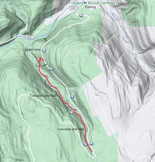
Henry Lott Brook is one of many beautiful streams in the wonderland that is SGL 57. The brook has carved a scenic gorge into the plateau filled with boulders, pools, grottos, slides, cascades and small waterfalls. There are no towering falls on this brook, but the scenery is non-stop. The hike into the gorge is off trail, there are no trails, signs or blazes. This hike is best for experienced hikers. Do not attempt in high water.
From the parking area, simply follow the gated forest road as is winds its way up the plateau. There are lots of wildflowers in the spring and summer. The road levels and reaches a logged area with some views. The road begins to veer left. Here, look for logging grades descending. Follow them as best you can, as far down as you can. Bushwhack down to the brook.
Now, follow the brook up. You will soon be treated to grottos with dripping springs and boulders. Cascades dance from everywhere. Moss and lichens carpet everything. You have entered a different world. We were amazed by the scenery. In places you will encounter landslides and thickets of birch trees. We found it was best to bypass them to the right, if heading upstream. These landslides and thickets are more of a problem in the lower half of the brook.
As we climbed, the scenery only improved. We reached more incredible cascades and massive boulders. Cliffs and ledges of the gorge reached over a hundred feet tall on the right. The brook tumbled down bedrock grottos with deep pools. The water was a deep amber from the spruce swamps at its source. Around every bend there was something to see.
We reached an amazing grotto covered in moss and layers of bedrock, framed by large smooth boulders. There was a ten-foot falls with a chokestone, we called it Chokestone Falls. A magical spot. But the brook didn’t stop. Ahead were jumbles of large boulders, cascades and mini gorges with bedrock slides. We reached a long bedrock slide with a cliff on the right, to the left were large boulders. We were going to try to do a grand loop with Somer Brook, but I wasn’t feeling well. We climbed to the road and hiked out, enjoying the wildflowers, and a black phase rattlesnake tightly coiled.
The map above is for general directional purposes. Red is off trail. The hike is 6-7 miles long and is rugged.
There are so many places of hidden beauty waiting to be explored. Get out there.
Parking is at 41.473815, -76.142560.
Photos and videos:
https://www.instagram.com/p/CTQanpgtVf_/?utm_source=ig_web_button_share_sheethttps://www.instagram.com/p/CS7g4IVFaOV/?utm_source=ig_web_button_share_sheethttps://www.instagram.com/p/CS2g-50Am7j/?utm_source=ig_web_button_share_sheethttps://www.instagram.com/p/CS2ip_agJm3/?utm_source=ig_web_copy_linkhttps://www.instagram.com/p/CS2zLOntKr1/?utm_source=ig_web_button_share_sheethttps://www.instagram.com/p/CS4LkF0gPIt/https://www.instagram.com/p/CS4PztfghU0/https://www.instagram.com/p/CS4acO8AXYo/Hiking at Lackawanna State Park
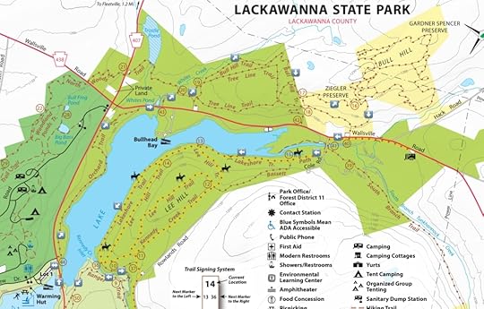
Lackawanna State Park has miles of hiking and mountain biking trails. While there aren’t mountainous vistas or towering waterfalls, I enjoy hiking here due to the diversity of habitats and scenery. The many trails create numerous loop options. This loop circles the northern half of the lake and is about 5.5 miles long. It has streams, meadows, views of the lake, and lots of hemlocks. Most trails have signs and many trail junctures are numbered.
Park at Lot 1, cross PA 407 and begin on the Orchard Trail as it meanders through pines, small meadows and through the woods with some views of the lake. Reach PA 438 and turn right onto the road, then left off the road onto Bull Hill Trail, a highlight of the hike. Bull Hill explores hemlock forests along Whites Creek and is a very scenic area. Reach a field and walk along the perimeter. Turn back into the woods, to the left, following the Bull Hill Trail. Enter a beautiful hemlock forest and climb gradually along the side of a hill. Snow covered the forest floor and draped the trees. Reach the top with large rock walls and hardwoods. Enter the Ziegler Preserve, owned by the Countryside Conservancy. We hiked the scenic trails in the preserve, and were going to hike into Gardner Spencer Preserve, but we did not have the time. So we made a loop in the Ziegler Preserve and descended to the parking area, crossing PA 438.
We followed a trail across the road down to the South Branch Tunkhannock Creek and crossed the bridge at Cole Road. We followed the Basset Path and then the Lakeshore Trail through groves of hemlocks and views of the lake. There were rock ledges off to our left. The next scenic area was the Kennedy Creek Inlet, a glen with hemlocks and a footbridge. We continued on the Ranger Trail to PA 407, turned right to cross the bridge and returned to Lot 1.
Parking is at 41.564287, -75.708262.
Support the Countryside Conservancy and visit their many preserves.
A map of the trails at the state park and surrounding preserves. Lots of hiking to do!
Photos:
https://www.instagram.com/p/CY42-2aveDo/?utm_source=ig_web_copy_linkhttps://www.instagram.com/p/CY7By7jP3vD/?utm_source=ig_web_copy_linkJanuary 21, 2022
Hike the Gooseneck (Buffalo Creek Gorge)- Bald Eagle State Forest
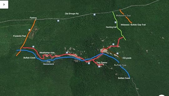
The Gooseneck is unlike any other place in Pennsylvania, a rugged gorge surrounded by vast fields of talus slopes. These talus, or rock, slopes, offer non-stop views. Gorges like this are rare in the ridge and valley region of the state. Buffalo Creek flows through the gorge and can be heard on the hike. This hike is very rugged, and most of it is off trail. Care is required to traverse the talus slopes. Do not attempt if the rocks are wet.
We began at the Frederick Trail along Old Shingle Road where there is space to park. This trail is blazed. It is best to follow it down to Buffalo Creek. At the creek, head off trail and hike down the creek, which is scenic. Reach the first large talus slope and climb. This is Weathertop and it has excellent views from the summit, including one looking down the gorge. This is a beautiful spot, so spend some time here.
A very rugged descent follows to the talus slopes below, which offer more views of the gorge. Some of the rock blocks are large, and some shift, so take care. The hiking is intense, but well worth it. We crossed the talus slopes and then dropped down to the creek, which we also crossed.
Next were the talus slopes on the south side of the creek, which offered even nicer views. We climbed to the Two Towers, where there was an excellent view looking down into the lowlands. The towers are massive rock cairns. We retraced our steps down and crossed the creek again, climbing the slopes to the north.
More views greeted us. We found an old grade which crossed the talus slopes, the workmanship to build something like this was impressive. We hiked the grade down a little to more fine views. However, we soon turned around and climbed the final series of talus slopes, to more, you guessed it, views.
We then entered the woods, fearing a gruesome bushwhack through laurel. To our surprise, we came upon a hunter’s trail that was fairly easy to follow, although it was faint in spots. This trail took us back to the road, which we followed to the cars.
This is an incredibly challenging and rewarding route for experienced hikers. The terrain is very different and unique, and the views are beautiful. This loop is 4-5 miles long. Parking is at about 40.949931, -77.198476.
For the map above, red is off trail. Orange are blazed trails, although they may be blazed a different color.
https://www.instagram.com/p/CXKGjm7P7z0/?utm_source=ig_web_copy_linkhttps://www.instagram.com/p/CXKE-H_vqW5/?utm_source=ig_web_copy_linkhttps://www.instagram.com/p/CXHsIu3vmHg/?utm_source=ig_web_copy_linkhttps://www.instagram.com/p/CXHmyoRPskl/?utm_source=ig_web_copy_link
November 17, 2021
Best Hikes in the Loyalsock State Forest
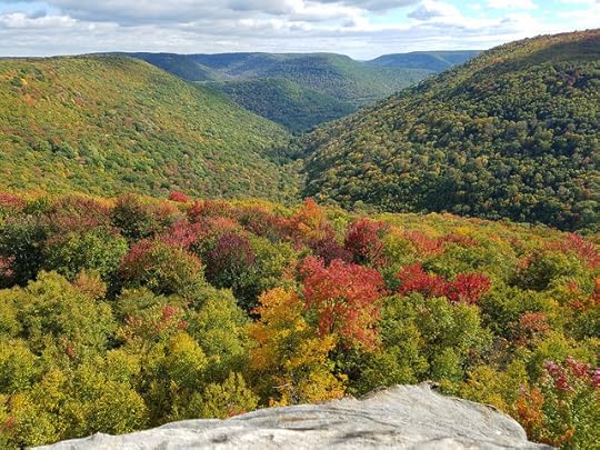
The Loyalsock State Forest is one of Pennsylvania’s beloved places due to its rugged scenery and outstanding outdoor recreation opportunities. It is home to waterfalls, gorges, ponds, chasms, giant rocks, hemlock forests, meadows and wetlands. There are whitewater rivers and numerous trails. Over the last ten or so years, it has evolved into a recreation destination due to its scenery and relative proximity to Philadelphia and New York. It is now host to some of the finest trail run competitions in the eastern U.S. The Loyalsock is a different place, serene and pristine, across its 115,000 acres. For the hiker, where should you go? The Loyalsock offers many hiking opportunities. Some of the parking below is pull off parking The following list is not in any particular order.
Haystacks and Dutchman Falls. A popular and fairly easy-moderate trail that is good for kids. Enjoy waterfalls, Loyalsock Creek, hemlock forests and the impressive Haystack Rapids, formed by Burgoon Sandstone, an ideal place for camping and swimming. No fires are allowed at the Haystacks. About five miles total. Park at 41.448291, -76.453318.Rough Hill Trail. A short, rugged and rocky trail to two excellent views. Do not miss the upper view, from which you can see the distinctive peak of Smiths Knob. About 2.5 miles long, moderate to difficult. Park at 41.397434, -76.759352.Angel Falls and Kettle Creek Gorge. This is the scenic heart of the Loyalsock with the area’s tallest falls, views, great camping, and cascades. Do not miss the falls below Angel Falls, including Gipson Falls. Kettle Creek is isolated and beautiful. You can make a nine mile loop with gated McCarty Road or the Ridge Trail. Moderate to difficult and best for more experienced hikers. Park at 41.385226, -76.668243.Dry Run Gorge and High Knob Loop. A rugged, challenging ten mile loop around Dry Run Gorge. Follow the High Knob, Loyalsock, and the bridle or Stony Run Trails. Enjoy waterfalls along Dutters Run, Mary’s View, High Knob Overlook, and a small backcountry pond. Begin at the Hillsgrove Ranger Station. Better for experienced hikers. Parking is at 41.420715, -76.704107.Ketchum Run Gorge. The gem of the Loyalsock, featuring an incredible gorge with waterfalls, chasm, cascades and pools, plus two vistas- Upper and Lower Alpine. Moderate to difficult. Use the Loyalsock, Fern Rock, and cross country ski trails to make a nine mile loop. Parking is at 41.437704, -76.608134.Fern Rock Nature Trail. An easier trail that is great for kids, and has some excellent scenery. There are hemlock forests, boulders, wetlands, meadows, and cascades and small falls on Ketchum Run. About three miles. Parking is at 41.437704, -76.608134.Sharp Top. Hike the Old Loggers Path from Pleasant Stream Road up to this stunning vista. Pleasant Stream is sizeable and has no bridge. Return the way you came. Dutters Run/Old Bark Loop. A 4.5 mile hike with gorges, view, and waterfalls using the Loyalsock, Old Bark and Dutters Trails. Moderate to difficult. Park at Dry Run Falls. Parking is at 41.430374, -76.670462.Smiths Knob and Painter Run. An excellent 6 mile loop with excellent views, including from the top of Smiths Knob. Finish the loop along scenic Painter Run and Little Bear Creek Road. Challenging. Parking at 41.356244, -76.859745.Jacoby Falls. Hike to a beautiful 35 foot falls, can be dry in summer. Great ice flows in winter. 1.5 miles one way, east to moderate. Parking is at 41.376781, -76.920105.Allegheny Ridge. Hike the Loyalsock Trail from PA 87 or Little Bear Creek Road to an excellent view from the Allegheny Ridge. Hike is easier from Little Bear Creek Road. Can make a great loop with the rugged, faint Graf Woolever Trail, which has cascades. About 5-6 miles in length. Parking is at 41.356244, -76.859745 or 41.361348, -76.877051.Matt Mertes Trail. A short loop with a nice view, pine forests, and a small stream with cascades. About two miles. Trail is at 41.354471, -76.912665.Rider Park. A separate park adjacent to the Loyalsock State Forest, this park has many trails with meadows and great views. Don’t miss the Katy Jane and Francis X. Kennedy Trails. Various lengths possible. Parking is at 41.34714203490246, -76.93652528242814.Rusty Falls and Shanerburg Run. Follow the bridle trail up along scenic Shanerburg Run with small cascades and meadows. An unmarked side trail leads to beautiful Rusty Falls. Complete the loop along Shanerburg Road. About four miles. Moderate in difficulty. Parking is at about 41.438860, -76.531650.Rock Run. One of PA’s most scenic streams with incredible bedrock pools, chasms, grottos, cascades and slides. Most people just walk along the creek, there is no trail system. Parking is along Rock Run Road.Miners Run. Hike up along the creek to stunning waterfalls and giant boulders. There is a trail on the east side of the creek, but it is high above the creek. Moderate to challenging, about a mile long. Pull off parking is at 41.515958, -76.916716.Devil’s Elbow Natural Area. Hike the Sand Spring Trail through hemlock forests, along creeks, and wetlands with diverse plant and animal life. Easy hike, about three miles. Parking is at 41.564650, -76.830177.Rattlesnake Point. Starting from Camp Susque, hike a narrow, rocky trail up past a seasonal falls and up a glen. It leads to an awesome view of the Lycoming Creek valley. About 2.5 miles, challenging. Parking is at about 41.419782, -77.033593, hike begins across PA 14. Bar Bottom Hollow. A more challenging hike with no official trails, follow old forest roads into a gorge with several beautiful waterfalls and cascades. Parking is at 41.377218, -76.891417.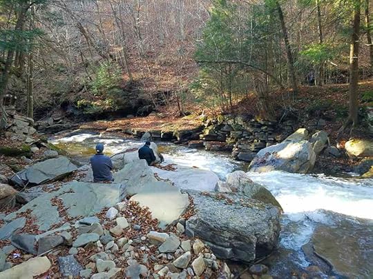
November 12, 2021
Hike to Chimney Rock-Tioga State Forest
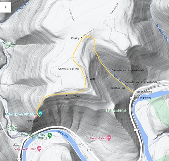
This hike leads to one of the finest views of Pine Creek. There are two ways to begin. You can begin along PA 414 and hike up the Bull Run Trail; this way is longer and more challenging, but makes the view more rewarding. The other way is to drive to the end of Old Mountain Road and park. This way is much shorter and easier, however, the road can be muddy and rutted, so a vehicle with clearance is recommended.
I began from PA 414 and hiked up the yellow Bull Run Trail. This was a scenic trail, and the steady climb wasn’t really all that bad. Bull Run is a small creek and can dry up in the summer. When flowing, it has many small waterfalls and cascades, making for great scenery. Moss, ferns, and hemlocks adorn the trail up Bull Run. As I reached the top, there were many saplings; this was an area that was burned in a fire years ago. The trail leveled off and went through the saplings and some small meadows. I then reached Old Mountain Road.
I turned left and followed the sign for Chimney Rock Trail, also blazed yellow. The trail went through groves of pine and along some meadows. This area was also burned years ago. The trail moved towards the edge of the plateau with some nice views through the openings in the trees; in winter the views would be extensive with the bare trees.
The hiking was level along the edge of the plateau and then a gradual descent began. I hiked past ledges and the descent steepened with large rock outcrops. The woods were open with oak trees. The final stretch to the view was quite steep, but manageable.
Chimney Rock Overlook is impressive with its views of Pine Creek, and the ridges, peaks, and plateaus that surround it. The terrain is diverse and beautiful. Hundreds of feet below is the rail trail and a bridge across the creek. There is a flag at the view. This view is great for sunrises.
There is another view, a short distance off trail, at the point of the plateau. It offers a great view looking down Pine Creek.
From here, retrace your steps.
Parking at PA 414 is at about 41.534728, -77.426813. Parking on Old Mountain Road is at 41.542423, -77.437155. From PA 414, this hike is about three miles, one way.
Scroll through the photos.
View this post on InstagramA post shared by Jeff Mitchell-Outdoors Author (@hiking_mitch)
View this post on InstagramA post shared by Jeff Mitchell-Outdoors Author (@hiking_mitch)
View this post on InstagramA post shared by Jeff Mitchell-Outdoors Author (@hiking_mitch)
View this post on InstagramA post shared by Jeff Mitchell-Outdoors Author (@hiking_mitch)
November 9, 2021
Hiking the Birch Trail-Tioga State Forest
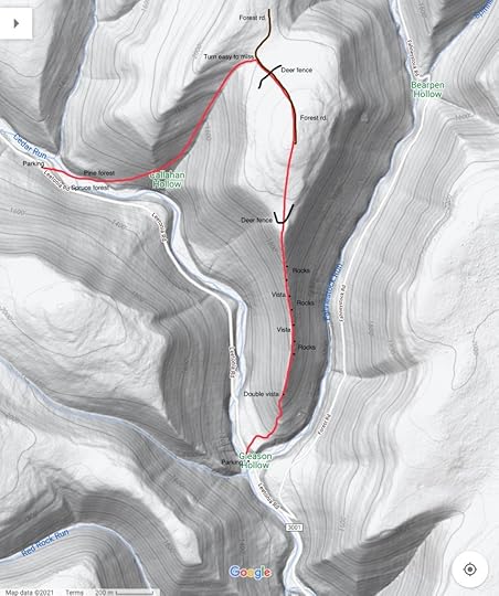
The Birch Trail is an isolated hike located deep in the Tioga State Forest, near Leetonia. It features a narrow ridge with views and many unique rock formations. The drive to it along Cedar Run is beautiful, with gorges and waterfalls. Cedar Run is a well-known trout stream with many pools, slides, and grottos. I began at the parking area in Gleason Hollow, it is pull off parking, and there is a beautiful bedrock pool in Cedar Run nearby. Cross the road and begin on the Birch Trail, where there is a sign.
The trail is blazed red and soon makes a steep climb up the ridge under pine trees. Leave the pine trees and reach the narrow ridge, where rock outcrops begin to appear. Scramble up some ledges and reach a scenic double vista off both sides of the ridge. Mountains and gorges surround you. Continue to follow the ridge with a moderate climb. The red blazes become more infrequent, but there is generally a path to follow. The narrow ridge is very unique, with many interesting rock outcrops and formations. There are columns of rock, and one formation that resembles a mushroom. The trail sign near the parking area calls these the “Chimney Rocks”. The ridge is often composed of ledges. Enjoy two views off the left, of west, side of the ridge. Climb up the ridge and reach the plateau, and a deer fence.
The trail crosses through the fence and becomes more overgrown with briars. The blazes are still there, but infrequent. This may be tough to follow in the summer. Climb gradually and reach the end of a forest road. Follow the road as it descends. Again, blazes along the road are infrequent. The trail makes a discreet turn to the left, it is easy to miss. Descend into Callahan Hollow and pick up an old grade. The trail curves into a scenic pine forest and descends to Cedar Run. There is no bridge across Cedar Run, so expect wet feet. There was a fallen tree a hundred feet or so upstream that you can cross.
The Birch Trail enters a beautiful spruce forest with moss. Climb up to Leetonia Road and another trail sign. Turn left and walk the road back to complete the loop.
This description follows the loop counterclockwise. While the ridge is the most scenic part of the hike, I enjoyed the entire loop. The loop is about four miles long.
Pull off parking is at 41.579730, -77.473997.
View this post on InstagramA post shared by Jeff Mitchell-Outdoors Author (@hiking_mitch)
View this post on InstagramA post shared by Jeff Mitchell-Outdoors Author (@hiking_mitch)
View this post on InstagramA post shared by Jeff Mitchell-Outdoors Author (@hiking_mitch)
View this post on InstagramA post shared by Jeff Mitchell-Outdoors Author (@hiking_mitch)
Jeff Mitchell's Blog
- Jeff Mitchell's profile
- 3 followers


