
Jeff Mitchell's Blog, page 15
January 12, 2021
Hike the Haystacks and Brook Kedron Loop-Loyalsock State Forest

The Haystacks have long been a popular hiking destination in the Loyalsock State Forest. For the more experienced and adventurous hiker, there is a great loop you can do along the unofficial Brook Kedron Trail. I’ve heard this may become an official trail, and it is shown on the Purple Lizard Map. When I hiked it, it was only marked with orange flagging. Be aware it can be a little hard to follow, especially south of Mead Road. Why hike Brook Kedron? It is a beautiful stream with many falls, slides, cascades, and a unique mini-gorge of fractured rock. It is a small stream; you can expect the best flow when the Loyalsock Creek is flowing over 3.0 feet on the USGS gauge. In summer, it will likely be dry except after a good rain. This loop is 5-6 miles long.
From the Loyalsock Parking area, just follow the Loyalsock Trail (LT) down to the old railroad grade and be sure to visit Dutchmans Falls. Continue on the Loyalsock Trail down the grade until the trail makes a sharp right and descends to the Loyalsock Creek. Follow the creek for some beautiful hiking. The trail veers from the creek, ascends a ridge, and drops down to the Loyalsock Creek again with campsites. An access road joins from the left. Soon reach the impressive Haystack Rapids with its giant white boulders and cascading water. It is a truly beautiful place.
The LT climbs the mountain back to the old grade and to a seasonal falls. Turn left on the grade until near where the access road descends to the left. Here, look for a trail and orange flagging to the right, follow it. The trail enters the glen of Brook Kedron with its cascades. The trail leaves the brook and climbs to the left to some ledges and boulders, but returns to the brook with a nice falls. Continue up the brook with more cascades and slides. Enter a beautiful mini-gorge of bedrock ledges. Continue upstream with more cascades. The trail leaves the brook to the left, this can be easy to miss. Upstream, and off trail, is a unique oxbow loop that is neat to photograph.
Reach Mead Road, where you have a decision. Turn left on the road and walk it back to the parking area for a shorter and easier loop. Or continue on the Brook Kedron Trail, which is harder to follow, at least on my hike. It follows the remnants of an old logging road under hemlocks and across meadows. Overall I found it scenic. Descend to a deer fence where the flagging ended. Turn right and follow the deer fence around and you will be behind the forestry buildings. Now follow the yellow trail (I can’t recall the name, maybe the Old Dushore Rd. Trail) as it explores the forest, crosses a swath, and descends under hemlocks to Mead Road. Turn left on the road and hike up to the parking area.
This is a beautiful loop, particularly if Brook Kedron is flowing well. Parking is at 41.448281, -76.453220.
For the map above, red is the LT, yellow are blazed trails, brown is the railroad grade or forest access road, green is the Brook Kedron Trail, only marked with orange flagging on my hike.
View this post on InstagramA post shared by Jeff Mitchell-Outdoors Author (@hiking_mitch)
View this post on InstagramA post shared by Jeff Mitchell-Outdoors Author (@hiking_mitch)
View this post on InstagramA post shared by Jeff Mitchell-Outdoors Author (@hiking_mitch)
View this post on InstagramA post shared by Jeff Mitchell-Outdoors Author (@hiking_mitch)
View this post on InstagramA post shared by Jeff Mitchell-Outdoors Author (@hiking_mitch)
View this post on InstagramA post shared by Jeff Mitchell-Outdoors Author (@hiking_mitch)


December 29, 2020
Hike to Scurry Overlook and Henry Run Falls-Cook Forest State Park

This is a great hike with a view, a falls at a unique and beautiful dam, and an incredible hike along the Clarion River. This hike is about 1.5 miles, one way. At the small parking area along Gravel Lick Rd, follow the blue blazed North Country Trail (NCT) to the east. Climb through laurel and reach Scurry Overlook with its nice view of the Clarion River below. The trail drops and then follows the side hill of the mountain, passing some boulders.
Descend to hemlocks and reach Henry Run, cross over it on a bridge. Walk downstream to see the unique old sawmill dam with its 10-12 foot falls. The dam is unique with its large blocks of stone. The fact that it is still standing is amazing and a testament to its workmanship. There is a bench to sit on along the Clarion River, below the falls.
We continued along the NCT and the Clarion River to the River Trail, at which point we turned around. What a beautiful hike along this pristine river, under large hemlocks. We could hear the rattling calls of the kingfishers across the water. From there we retraced our steps.
The NCT is an incredible hiking destination across western Pennsylvania, featuring historic towns and diverse scenery.
Parking is at about 41.320285, -79.245390.
Scroll through the photos.
View this post on InstagramA post shared by Jeff Mitchell-Outdoors Author (@hiking_mitch)
December 28, 2020
Hike the Forest Cathedral-Cook Forest State Park

The iconic Forest Cathedral is one of PA’s must-see destinations. An incredible forest of towering white pines and hemlocks, these trees are nearly 200 feet tall, among the tallest in the eastern US. And Cook Forest has over 2,000 acres of old growth forest, among the largest in the east. These trees are simply breathtaking as they soar through the canopy, allowing you to see what the forests looked like prior to the arrival of man. Old growth forests are very important. They are the most biodiverse of the forests, hold the most carbon, and retain the most water, offering protection from floods. Forest Cathedral is also a National Natural Landmark.
With a web of trails, there are many possible loops at Forest Cathedral. Park at the new park office and hike the Birch Trail above Toms Run. Cross the swinging bridge and enjoy views of the babbling, clear stream below. Turn left onto Toms Run Trail and hike along the creek with its pools and rapids. Veer right onto the Longfellow Trail and begin to climb into the old growth forest. Enjoy the giant trees. This trail is also marked blue for the North Country Trail, the longest in the nation that goes from North Dakota to Vermont.
We were lucky to hike this forest on a sunny winter morning after a fresh snowfall. The scenery was incredible with the shafts of light and powder drifting down from the trees. A truly unforgettable experience.
Turn left onto the Ancient Forest Trail and descend into a stream valley and climb back to the Longfellow Trail. Turn right. Climb up the hill and turn right onto Indian Trail and then a quick right onto Joyce Kilmer Trail. The terrain is level and rolling. Even the fallen trees are impressive to look at. Many fallen trees are coated with moss and harbor ferns and mushrooms. Veer right onto the Indian Trail and continue to descend. The trail switchbacks above a steep slope as Tom’s Run flow far below. Drop down to the cabin area and hike the road back up to the park office.
Park at 41.333291, -79.209343. This hike is about 2.5 miles long. Cook Forest State Park has a vast trail network that is a hiking wonderland.
View this post on InstagramA post shared by Jeff Mitchell-Outdoors Author (@hiking_mitch)
View this post on InstagramA post shared by Jeff Mitchell-Outdoors Author (@hiking_mitch)
View this post on InstagramA post shared by Jeff Mitchell-Outdoors Author (@hiking_mitch)
View this post on InstagramA post shared by Jeff Mitchell-Outdoors Author (@hiking_mitch)
December 23, 2020
Hike the Minister Creek Middle and South Loops-Allegheny National Forest

Minister Creek is the most popular hiking trail in the Allegheny National Forest, and with good reason. This valley features a pristine stream and numerous cliffs, rock outcrops and chasms. These giant sandstone monoliths rise through the forest and are often clothed in moss, lichens and ferns. It had been several years since I’ve hiked at Minister Creek and it was great to return. We did a short hike on the South and Middle Loops and to the overlook. This loop is about three miles long. The trails have signs and are blazed with diamond shaped white/grey placards.
From the parking area, hike up the trail and turn left to start the south loop. Begin a steeper climb up an old grade. Enter hemlocks with some giant boulders. The trail veers left, passes an old oil well and reaches dramatic cliffs and rock outcrops. Take time to explore them. The trail ascends to the top of the cliffs and veers left. Turn right down into a maze between the giant rocks, the scenery is superb. Continue along the escarpment of cliffs and ledges with large hemlocks. Climb to the top of the plateau and pass through laurel. Reach the Minister Creek Overlook and its fine views over the valley. Continue on the middle loop and descend under dramatic outcrops, and even boulders stacked on top of each other. The trail meanders down the mountain, passing more giant rocks. Follow a level trail to the end of the loop. Retrace your steps back to the parking area.
It is well worth your time to hike the entire Minister Creek trail system, which serves as both a dayhike and backpacking destination. However, if you only have an hour or two to spare, the south loop is a perfect hike and one of the most scenic in the Allegheny National Forest.
Parking is at 41.620578, -79.153603. For the map above, black dots are large rocks and boulders.
View this post on InstagramA post shared by Jeff Mitchell-Outdoors Author (@hiking_mitch)
View this post on InstagramA post shared by Jeff Mitchell-Outdoors Author (@hiking_mitch)
View this post on InstagramA post shared by Jeff Mitchell-Outdoors Author (@hiking_mitch)
View this post on InstagramA post shared by Jeff Mitchell-Outdoors Author (@hiking_mitch)
December 21, 2020
Hike the Beaver Meadows Trail System-Allegheny National Forest

Beaver Meadows is one of the best kept secrets in the Allegheny National Forest. The terrain is easy with great diversity, and plenty of opportunities to see birds and wildlife. It has a beautiful lake, boardwalk, meadows, moss, wetlands, and gorgeous spruce and pine forests. The trails are marked with signs and white/grey diamond placards. While the terrain is easy, be prepared for wet and boggy conditions along parts of the trail. This loop is about five miles long.
We began at the parking area and walked down to the dam, crossing it with great views over the water. Next was the Salmon Creek Loop with views over meadows, beaver dams, and extensive red pine forests with a grove of spruce trees. The route rejoined the Beaver Meadows Loop which featured stunning spruce and moss forests. Lakeside Trail offered views of the lake and we returned to the Beaver Meadows Loop before turning right onto Penoke Path with its spruce, moss, and hemlock forests with small meadows. The trail followed an old railroad grade along a large meadow.
Next was the boardwalk, and at about 500 feet long, one of the longest in PA. First, it was wet and boggy just to reach it. While exhilarating, it was also tricky as it was listing a little so we got on our knees to cross. The layer of snow didn’t help matters. However, the views across the wetlands and open water were beautiful. The trail continued through spruce forests and small meadows. We lost the trail at one meadow with a large pine tree, but soon found it again, crossing a bridge over a creek. The trail turned left onto an old railroad grade and then turned right off the grade, heading west and crossing several small streams over footbridges in evergreen forests. The trail returned us to the parking area.
Beaver Meadows is a beautiful place and often doesn’t have the crowds as other trails in the Allegheny National Forest. Parking is at 41.522513, -79.111095.
View this post on InstagramA post shared by Jeff Mitchell-Outdoors Author (@hiking_mitch)
View this post on InstagramA post shared by Jeff Mitchell-Outdoors Author (@hiking_mitch)
View this post on InstagramA post shared by Jeff Mitchell-Outdoors Author (@hiking_mitch)
View this post on InstagramA post shared by Jeff Mitchell-Outdoors Author (@hiking_mitch)
Clarion Loop Trail

The Clarion Loop Trail is a hike of about two miles located behind Clarion University, in Clarion, PA. It features stunning hemlock forests, streams, sandstone boulders, cascades and falls, and fine views of the Clarion River. It is blazed white. It is a beautiful hike that should be on anyone’s list. We had the luck to hike this trail after a fresh snowfall. The beauty was incredible.
From the parking area, hike the short connector trail and quickly enter the forest and the cathedral of hemlocks. The start of the loop is easy to miss; we hiked to the right or counterclockwise. The trail explored forests of hemlock with some rhododendron along the ravine of a cascading stream. Moss covered sandstone forests dotted the forest floor. The trail descended to the creek and crossed it at the ruins of a breached stone dam. There is no footbridge so this can be a tough crossing in high water. These ruins blend into the scenery and can be easy to miss.
The trail meandered down to the Clarion River with more giant hemlocks. The final descent to the river is steep. Reach the river and enjoy the views, and the glen of a creek with large boulders, cascades, and falls. We hiked up the trail as large boulders and outcrops loomed over the trail. The trail neared the glen of the creek and we could see cascades and boulders below. We followed switchbacks under hemlocks and made our way up the slope. We continued to be amazed by the beauty. The trail leveled off and a blue blazed trail joined from the right. We soon completed the loop and returned to the car.
This is a great hike with excellent scenery. If you love beautiful forests with big hemlocks, put this trail on your list. Parking is at 41.211688, -79.375335.
View this post on InstagramA post shared by Jeff Mitchell-Outdoors Author (@hiking_mitch)
View this post on InstagramA post shared by Jeff Mitchell-Outdoors Author (@hiking_mitch)
View this post on InstagramA post shared by Jeff Mitchell-Outdoors Author (@hiking_mitch)
View this post on InstagramA post shared by Jeff Mitchell-Outdoors Author (@hiking_mitch)
December 15, 2020
Backpacking the Panther Run and Three Runs Loop-Quehanna Wild Area

The vast Quehanna Wild Area is a hiking destination with a wide network of trails creating countless loop options. The Quehanna is known for its diverse habitats and scenery, and is home to wild elk herds. This loop is about 20 miles and is ideal as an overnight backpack or a long dayhike. I backpacked it. Parts of this hike are wet and there are stream crossings without bridges. Much of the route is level or rolling, but the eastern part of the loop is more rugged. This route was easy to navigate, the trails are in decent shape and many have signs.
From the parking area at Hoover Farm, take the yellow David Lewis Trail as it explores meadows, wetlands and spruce forests. It is a scenic trail. Parts of this trail are similar to Dolly Sods in West Virginia. Reach Reactor Road and turn left onto the yellow Panther Run Trail. This is a highlight of the loop as I hiked through a stunning spruce and moss forest; thick carpets of moss covered the forest floor. The scenery was incredible. The trail then crossed a vast meadow with beaver dams and rock outcrops in the distance. Hike along a creek with small meadows and then climb into the forest. Turn right onto an old forest road, descend to a creek and cross on a bridge and then turn right onto Kunes Camp Trail.
This is another great trail as it passes boulders and descends for a beautiful streamside hike with possible camping. Enjoy the cascades and pools with hemlocks and laurel. Turn right onto Erie Camp Trail, an old forest road, descend, cross a creek, and climb to the plateau with white birch trees. Explore open woodlands and then turn right onto Cole Run Trail, a short connector to the orange Quehanna Trail (QT). Turn left on the QT as it explores more open hardwoods with laurel and descend to Cole Run. It was here when I heard a snap of a branch, looked up, and saw a herd of elk and a giant bull. These animals were so massive, yet moved through the forest with grace and ease. An amazing, and little intimidating, experience. I reached Cole Run and met my friends at camp. We enjoyed the night sky and its incredible display of stars.
The next morning was overcast and I got on the trail early, following the QT up a creek with laurel, hemlock and pine. I hiked near a meadow, passed through a spruce forest and crossed the Quehanna Highway. The trail continued into an open forest, passing springs, small meadows, and laurel thickets before reaching Rider Draft Vista, a modest view to the south. Open hardwoods and laurel continued until the steep descent to Upper Three Runs with a long footbridge, and a small reservoir downstream. A sign also indicated the availability of camping. A climb followed as the trees creaked from the winds of a coming storm. At the top, there were two views. One looked south and wasn’t much of a view. But the second view to the west was very nice as it looked into a wooded gorge.
The trail then explored open hardwoods and then entered a hemlock forest and wet area with a short boardwalk. I reached Three Runs Tower Road and followed the QT. At the site of the former firetower is a juncture with the No. 14 Trail, an ideal shortcut with meadows and spruce. Otherwise, continue on the QT as it passes Three Runs Vista, steeply descend to Lower Three Runs and climbs to a juncture with the No. 15 Trail. Go straight onto this trail to Three Runs Road. Go left on this road and then turn right on Big Spring Draft. Pass a walled spring and descend on this gorgeous trail with rhododendron, pine, and hemlocks along a creek. There are two nice campsites. Cross the creek and climb into open hardwoods and wetlands. Turn left onto Wykoff Trail, left on Ligament Trail and then a quick right onto a red trail back to the Hoover Farm parking area.
Parking is at 41.229061, -78.191713. For the map above, “C” are campsites or potential campsites.
View this post on InstagramA post shared by Jeff Mitchell-Outdoors Author (@hiking_mitch)
View this post on InstagramA post shared by Jeff Mitchell-Outdoors Author (@hiking_mitch)
View this post on InstagramA post shared by Jeff Mitchell-Outdoors Author (@hiking_mitch)
View this post on InstagramA post shared by Jeff Mitchell-Outdoors Author (@hiking_mitch)
View this post on InstagramA post shared by Jeff Mitchell-Outdoors Author (@hiking_mitch)
View this post on InstagramA post shared by Jeff Mitchell-Outdoors Author (@hiking_mitch)
View this post on InstagramA post shared by Jeff Mitchell-Outdoors Author (@hiking_mitch)
Bear Creek Preserve-Hike the Purple and Grey Loop
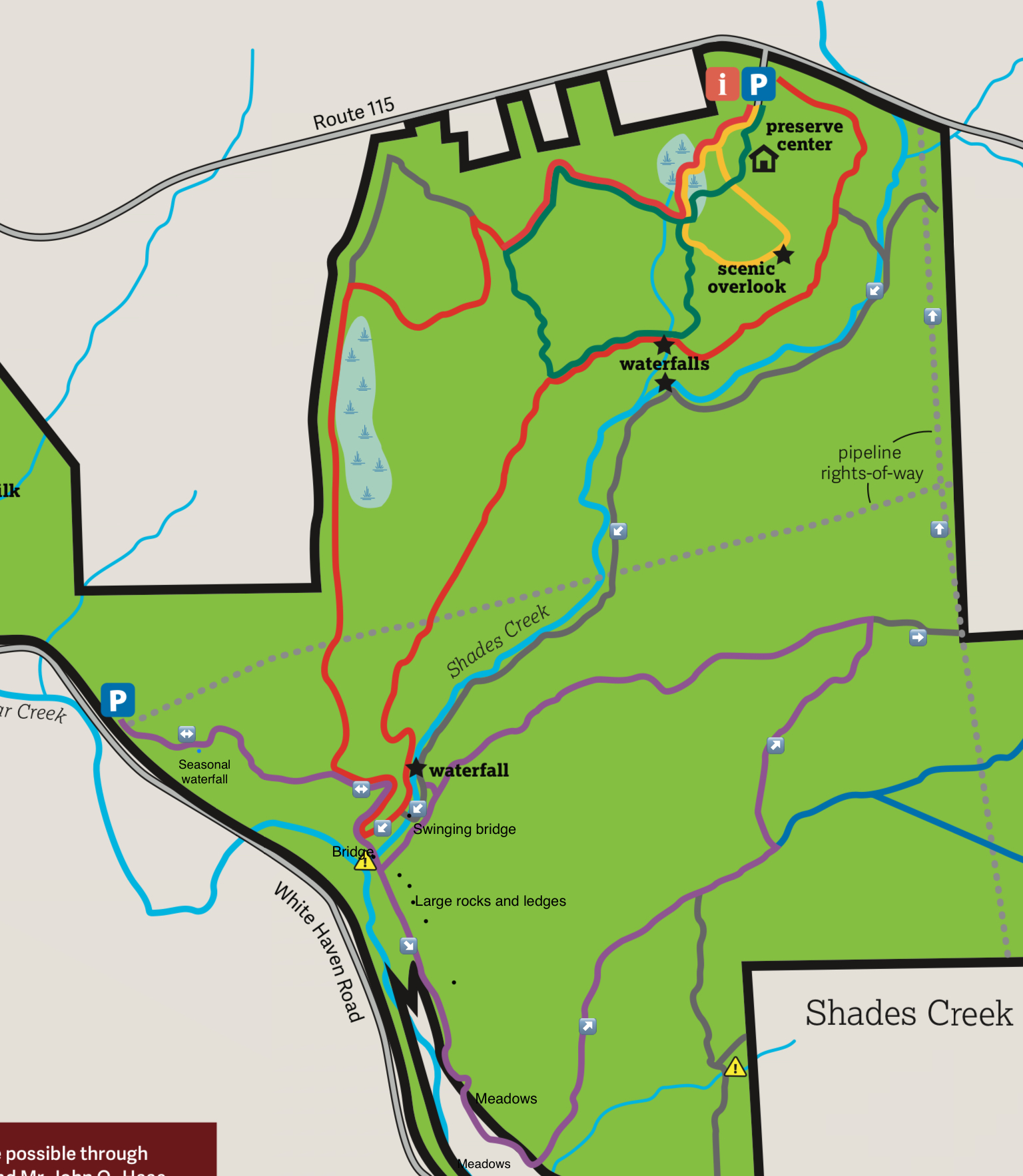
Bear Creek Preserve has become a hiking destination thanks to its network of trails, scenic beauty, and accessibility. While most people do a loop on the grey, red, and yellow trails around Shades Creek, there is another loop you can do that I think is even more isolated and diverse.
This loop follows the purple and grey trails, and the pipeline swath. This hike begins at the parking area along White Haven Road. Park at 41.160327, -75.734372. This loop is about 8.5 miles long.
Follow the purple trail across a pipeline swath and into the woods. Reach a glen with a seasonal ten foot falls that you can go behind. Hike among laurel and hemlock and re-enter the open hardwoods along a pleasant trail. Reach the red trail and follow the purple trail right down along rock outcrops and into hemlocks. Enjoy views of Bear Creek and cross Shades Creek on a log bridge. Large rocks and ledges are off to the left. Reach beaver dams and meadows with fine views. The trail enters large meadows near the Francis Walter Reservoir. When the reservoir is filled, this is very scenic. When the reservoir is drawn down in winter, it has a post-apocalyptic feel to it. The trail turns right and enters open hardwoods and begins a long gradual climb.
The purple trail descends to a gray trail, turn right onto it and reach the pipeline swath. Walk the swath which offers a change of scenery and opportunities to see wildlife and wildflowers. Descend into Shades Creek valley and reach wet areas. Look left for the grey trail, it can be easy to miss. Follow this trail into gorgeous hemlocks along a creek to the right and ledges to the left. Continue on the gray trail along Shades Creek. This trail is so beautiful with cascades, slides, pools, hemlocks and rhododendron jungles. It is an absolute joy to hike. Continue on the gray trail pass the waterfall and onto the swinging bridge with great views over Shades Creek. Turn left onto the red trail and rejoin the purple trail. Turn right onto this trail to go back to your car.
Bear Creek Preserve is an amazing place that we are lucky to have.
https://www.instagram.com/p/CIMWYWfDqnd/?utm_source=ig_web_copy_link
View this post on InstagramA post shared by Jeff Mitchell-Outdoors Author (@hiking_mitch)
View this post on InstagramA post shared by Jeff Mitchell-Outdoors Author (@hiking_mitch)
December 14, 2020
White Gold Superloop-SGL 57 and Ricketts Glen State Park

The White Gold Superloop is the third in the superloop series. While shorter and not as challenging as the Golden Eagle/Hilborn or Slate Run Superloops, it offers diverse scenery, isolation, and its own unique set of challenges. It is named after a book by Peter Tomasak, “White Gold of Mountain Springs”, which describes the ice making industry and the town of Mountain Springs, which was once located here. The history of this region is remarkable, once home to towns, schools, and stores. It was an important place for the creation and distribution of ice, which was needed before the invention of refrigeration. Some ruins from that era remains, but nature has largely taken over. A variation of this loop is described in “Hiking the Endless Mountains”. This loop is located in SGL 57 and Ricketts Glen State Park. This loop is about 11 miles long.
Before hiking this loop, understand a few things. The trails are unmarked and have no signs, although they are generally well established and often have cairns at intersections. The trails will be hard to follow in the snow or from fallen leaves. There are wet areas, and stream crossings without bridges. The Bean Run crossing will be difficult in high water. You should be an experienced hiker with good navigational skills to hike this trail. This hike is notable for its diversity with vistas, big rocks, wetlands, meadows, spruce trees, superb streamside hiking, and Beech Lake. It is very different from other Pennsylvania hikes.
From the parking area at Bowmans Marsh, walk down the road and turn left onto gated Beech Lake Road. Follow the road to the left. Now look for a trail entering the woods to the right, take it. It meanders through scenic woodlands and reaches cliffs with fine views. Descend with large rocks and ledges off to the left. Drop down to Mountain Springs Road and cross it. This is the confusing part. Follow the trail in a southeasterly direction, veer right on a grade as it descends, turn sharp left onto another grade at the bottom. The log cribbing of one of the ice dams, now breached, is off to your right, off trail.
Hike the grade to a small meadow, turn right, descend along the meadow with some stone ruins into a hemlock forest along Bowmans Creek. Follow the trail along the creek. The scenery is very beautiful with the creek, hemlocks and rhododendrons. This is a highlight of the loop. Cross Wolf Run, reach the road, cross a meadow and hike up Wolf Run on an old grade. At the top, turn right and hike out to Coyote Rocks and its fine views, return the way you came. Continue on the loop, passing through scenic meadows and glades. Descend to Bean Run with spruce and wetlands. Descend along scenic Bean Run with cascades and giant rocks. Cross Bean Run and turn right at the next intersection. Cross a tributary and hike up, turn left, crossing it again with cascades. Reach Beech Lake Road, turn right, and then left into the woods on the trail as it wraps around the lake, offering some beautiful views over the water. This lake is unique for being undeveloped and natural. Reach the other end of the lake, turn left on an old grade and hike out to Beech Lake Rd, completing the loop. Retrace your steps back to your car.
Parking is at 41.359618, -76.235291; it is not accessible with snow and can be muddy in Spring. The route on the map is yellow. Red are other trails. Enjoy this beautiful hike.
Scroll through the photos below.
View this post on InstagramA post shared by Jeff Mitchell-Outdoors Author (@hiking_mitch)
View this post on InstagramA post shared by Jeff Mitchell-Outdoors Author (@hiking_mitch)
View this post on InstagramA post shared by Jeff Mitchell-Outdoors Author (@hiking_mitch)
View this post on InstagramA post shared by Jeff Mitchell-Outdoors Author (@hiking_mitch)
View this post on InstagramA post shared by Jeff Mitchell-Outdoors Author (@hiking_mitch)
November 18, 2020
Hike to Panther Hill Vista and Panther Creek Falls-Pinchot State Forest
This hike is in the northern part of the Thornhurst Tract of the Pinchot State Forest. It leads to a scenic cascading waterfall and a beautiful view from Panther Hill. It’s not often when there is a great view and a falls along the same and relatively short hike. Once you leave the road, this hike is off trail. Hopefully someday the Pinchot Trail will be extended to include the view and falls.
High Bridge Road leads to the parking area. It is a dirt road and a little rugged, although a car can handle it. However, a vehicle with some clearance is a good idea. From the parking area, walk around the gate and follow the road. It descends to Panther Creek and crosses it. Continue on the road as it inclines and reaches a creek to the left, also Panther Creek. Here, leave the road and hike up along the creek. The forest is not brushy, but there are saplings and the protruding branches of beech trees. Reach Panther Creek Falls at, a 20 foot falls with several drops in a scenic rocky glen, located at approximately 41.279953, -75.627438. Continue up the creek a short distance; you will want to turn left and climb to work your way up to the vista on Panther Hill. You will pass old forest and logging roads, or ATV trails, but none go in the direction you need. Continue to climb. You will encounter steep rocky slopes with ledges. There are many ways to make the climb, simply choose the route that is best for you.
Reach the vista at 41.278351, -75.620993 and enjoy the stunning 180 degree views. You can see for over 40 miles with the vast plateaus of SGL 57 in the distance. The Nesbitt Reservoir can also be seen, as well as the point of Bald Mountain. The panorama is spectacular with many ridges and deep valleys. In October, the lowbush blueberry bushes at the vista turn a vibrant red, making the view that much more beautiful. South of the vista is an escarpment of cliffs with more views, although Panther Hill Vista is the most scenic. Views of this magnitude are rare in the Thornhurst Tract of the Pinchot State Forest.
Retrace your steps back to the car. Parking is at 41.291152, -75.623762. For the map above, red is off trail.
View this post on InstagramA post shared by Jeff Mitchell-Outdoors Author (@hiking_mitch)
View this post on InstagramA post shared by Jeff Mitchell-Outdoors Author (@hiking_mitch)
View this post on InstagramA post shared by Jeff Mitchell-Outdoors Author (@hiking_mitch)
View this post on InstagramA post shared by Jeff Mitchell-Outdoors Author (@hiking_mitch)
Jeff Mitchell's Blog

- Jeff Mitchell's profile
- 3 followers


![[image error]](https://endlessmountains.files.wordpress.com/2020/11/6c1c32fe-f0ed-44aa-86db-37411b2eda6e.jpeg)