Jeff Mitchell's Blog, page 13
September 16, 2021
Hike to the Sinnemahoning Canyon Vista and Sinnemahoning Spine-Elk State Forest
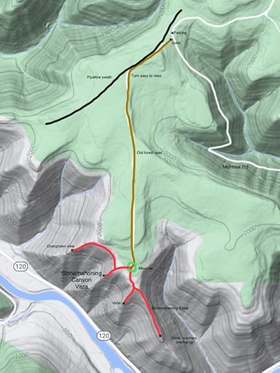
The PA Wilds are a special place, and one that I enjoy visiting. Its isolation, rugged terrain, countless trails, parks, streams, and wild elk make it an ideal destination. One of the most scenic places in the PA Wilds are around Sinnemahoning and Driftwood. Here, towering plateaus and deep canyons rise above the large Sinnemahoning Creek. This hike leads to one of the most stunning vistas over the Sinnemahoning Creek, and one of the finest views in all of the PA Wilds.
I first did this hike over a year ago, when I looked for a view that turned out to be quite nice. Little did I know a really spectacular view was on a ridge just to the west. Suspecting there was such a view, I returned to explore more. I parked at a pull off along Montor Road and walked around a gate, heading south on an old forest road. No trails have blazes or signs. The old road soon joined a grassy pipeline swath, which I followed for several hundred feet. Watch for a discreet turn to the left through some pine trees. Follow the old road through laurel and open hardwoods with ferns. The old road is easy to follow, although it is a little brushy in places. I hiked on a bright sunny day, which illuminated the forest with a fluorescent green. Ferns waved in the wind, just turning yellow as Autumn approached.
The old road descended gradually and ended at an open meadow. I headed west, off any trail, crossing some springs and walked through the open woods at the edge of the plateau. A strong wind blew down the canyon. I then reached an area, several hundred square feet in size, of uninterrupted moss carpeting the forest floor. I then dropped down this ridge, which became steep over some ledges. The ridge leveled and brought me to a stunning, incredible view of the Sinnemahoning Canyon. This was a 180 degree view of the 1,300 foot deep canyon, with ridges, plateaus, and gorges. The view would be incredible for sunrise or sunsets, and would be amazing above the mist and clouds in the morning. The view is from a towering, reddish rock outcrop. One rock at the view looked like an anvil. I sat here for a while, amazed by the beauty. The shadows of clouds sailed across the mountains. I could see up the gorge of another creek, where a long, sloping ridge looked ribbed from the drainages of small side streams. I called this view the Sinnemahoning Canyon Vista.
I then headed west, off trail, along some old deer paths through the laurel. I hiked to the next ridge to the west to look for another rock outcrop. I found it, but the view was largely overgrown. I retraced my steps and hiked down to the Sinnemahoning Spine, a very narrow ridge with views, ledges, overhangs and outcrops. It is a unique and beautiful feature. Wooded slopes plummeted from both sides of the narrow ridge. The ridge had small grassy meadows and twisted pine trees. The spine ended at a nice view and some large rock overhangs. The spine would be beautiful when the leaves are off the trees.
I then hiked over to the “original” vista from my first hike here; noted as “vista” on the map above. The view and rock pedestals make this a beautiful spot. From there, I returned to the meadow and hiked back out to Montour Road. Montour Road is in good shape and a car can handle it. However, do not drive on it if there is snow or ice. This hike is about six miles long.
Parking is at 41.325439, -78.042667. Sinnemahoning Canyon Vista is at 41.302421, -78.051076. The other vista is at 41.300120, -78.048657. Sinnemahoning Spine is at 41.296699, -78.044167.
For the map above, red is off trail. However, the woods are open and walking is fairly easy, although steep down to the vistas. Brown is an old forest road. No trails have blazes or signs.
Enjoy this incredible place! Pennsylvania is beautiful.
View this post on InstagramA post shared by Jeff Mitchell-Outdoors Author (@hiking_mitch)
View this post on InstagramA post shared by Jeff Mitchell-Outdoors Author (@hiking_mitch)
View this post on InstagramA post shared by Jeff Mitchell-Outdoors Author (@hiking_mitch)
View this post on InstagramA post shared by Jeff Mitchell-Outdoors Author (@hiking_mitch)
View this post on InstagramA post shared by Jeff Mitchell-Outdoors Author (@hiking_mitch)
View this post on InstagramA post shared by Jeff Mitchell-Outdoors Author (@hiking_mitch)
August 27, 2021
Stone Cutter and Tiadaghton Trail Loop-Tiadaghton State Forest
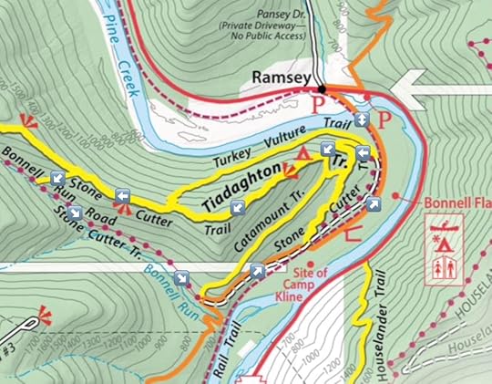
This is a great dayhike loop in the Pine Creek Gorge, offering views of the creek, rail trail, two fine views, rock outcrops and a small stream. It is about five miles long. Parking is at two places in Ramsey, and both have limited parking for about four or five cars.
From the parking area, follow the rail trail to the left or south and cross Pine Creek on an old steel bridge. Enjoy views of the creek and surrounding canyon. Continue on the rail trail and look for a discreet trail juncture to the right. Take it and follow the yellow blazes. Continue straight up the hill on the Tiadaghton Trail. Reach an old quarry site, and the climb becomes steeper; avoid the trails that join from the left. The climb remains steep as you ascend the ridge, passing some rock outcrops. Reach the ridge with more unique rock outcrops and ledges. Another climb brings you to a stunning 180 degree view of the Pine Creek gorge from rock outcrops. Enjoy the superb scenery.
Continue on the yellow Tiadaghton Trail as it climbs up the ridge; however, this climb is much more gradual. Moss and pine trees often adorn the trail. Descend gradually along the narrow ridge. In winter, expect extensive views through the bare trees. The yellow Turkey Vulture Trail joins from the right. Reach a second view looking down the gorge, another beautiful sight. Turn left onto a trail and leave the Tiadaghton Trail. Descend to the Stone Cutter Trail which follows an old forest road above Bonnell Run, a small, babbling creek with some small cascades. Follow the Stone Cutter Trail down, enjoying views of the creek and the valley. The trail does not get very close to Bonnell Run.
Reach the orange Mid State Trail, and you can go either way. Left will take you along an old grade that will descend to the rail trail. Right, or straight, will take you down Bonnell Run and you can connect to the rail trail at the bottom; just be sure you do not continue following the Mid State Trail up the mountain.
Hike the rail trail to the left with many wildflowers. Pass a camping area and some shelters. Cross the bridge over Pine Creek and retrace your steps.
Parking in Ramsey is at 41.284498, -77.324630 or 41.284322, -77.321053. Again, parking is limited.
View this post on InstagramA post shared by Jeff Mitchell-Outdoors Author (@hiking_mitch)
View this post on InstagramA post shared by Jeff Mitchell-Outdoors Author (@hiking_mitch)
View this post on InstagramA post shared by Jeff Mitchell-Outdoors Author (@hiking_mitch)
July 30, 2021
Explore Falls Creek and Long Valley Run-SGL 36
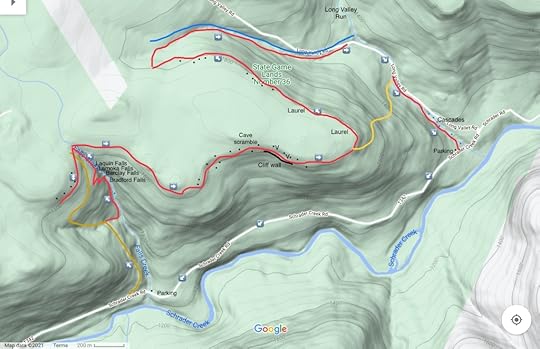
This hike explores impressive waterfalls and giant rocks. It is largely off trail and should only be attempted by experienced hikers. The Schrader Creek valley is a remarkable place to explore, with many waterfalls, views, giant rocks, mines, and other ruins from the mining era. Schrader Creek itself has many whitewater rapids and attracts paddlers when the water is high. It is a special, and relatively unknown, area.
For this hike, park near Long Valley Run, as that parking area is larger. If you don’t have two cars for a shuttle, walk Schrader Creek Road to Falls Creek. Cross the bridge over Falls Creek and continue on Schrader Creek Road for a short distance. Turn right onto an old forest road (brown on the map) with an established footpath. Hike up it. Cross a side stream and reach a meadow. Leave the old forest road and follow a trail down to Falls Creek. Enjoy all the falls and cascades. It is a beautiful creek. Hike up the creek to see more waterfalls. Enter a gorge and reach Bradford Falls, about 70 feet tall. This is an incredible falls. The old logs and stones that once cluttered the base of the falls have mostly washed away, making the falls even more scenic.
Now you must get around Bradford Falls; you can scramble up either side, but I usually go on the west side. Be careful as the terrain is steep. Above Bradford Falls is a gorge and scenic Barclay Falls, about 30 feet tall. Continue upstream to a gorge with cliffs and cascades. Reach Lamoka Falls, and above that, Laquin Falls. The hemlocks enhance the scenery along this already beautiful creek. Falls Creek is one of the finest waterfall gems in the Endless Mountains.
At the top we saw and old mine and headed west along the escarpment of the plateau, following a grade. There were large cliffs, rocks, and remnants of old mines. The graded faded into laurel and we turned around, returning to Falls Creek. We crossed the creek and walked through a hemlock forest, heading towards the escarpment. The laurel was moderately thick in places, but overall was not bad. We reached the escarpment, enjoying some large rock outcrops. We continued on, exploring more rocks and ledges, while finding passage through the laurel. I saw some large rocks above us, so we hiked up. There were giant boulders, and a cave we scrambled through. The scramble was a ton of fun. We explored more rocks and then went closer to the escarpment to enjoy a view through the trees.
Next was a hike on top of an impressive cliff line, it was beautiful with the pine and hemlocks. A bear path offered easier passage on top of the cliffs. I hope to return to explore the base of the cliffs. We reached another outcrop with a partial view, but three beautiful yellow phase rattlesnakes claimed it for themselves. We gave them a wide berth and moved on along the cliffs. The cliffs revealed some unique formations and chasms. We continued on, but the rocks became smaller and the laurel began to take over. We battled some laurel and saw more large rock outcrops and boulders. We reached an unnamed tributary of Long Valley Run and descended, passing small cascades. We reached a grassy road along Long Valley Run and walked down it. While this section was scenic, I’m not sure it was worth the effort. As a result, you might want to consider the yellow route on the map as a shortcut to the Long Valley Run Cascades.
Where the forest road crossed Long Valley Run, we went off trail and followed the creek downstream. While Long Valley Run does not have towering waterfalls, it does have an assortment of beautiful, unique cascades with bedrock that almost seems sculpted and polished. It was a highlight of this hike. The water was also a unique shade of translucent blue. The car and parking area were nearby. This hike is 6-7 miles long if you also hike the road.
Falls Creek and Long Valley Run are described separately in Hiking the Endless Mountains.
Parking is at 41.650020, -76.568232 for Long Valley Run, or 41.641295, -76.593426 for Falls Creek.
For the map above, brown is an old forest grade, red is off trail, black dots are large rocks and boulders. V is for vistas, which are partial views.
Photos:
https://www.instagram.com/p/CRpGTvzNdVv/?utm_source=ig_web_copy_linkhttps://www.instagram.com/p/CRaXkZ0N7VC/?utm_source=ig_web_copy_linkhttps://www.instagram.com/p/CRMJyffNrY6/?utm_source=ig_web_copy_linkhttps://www.instagram.com/p/CRK7R15tlBy/?utm_source=ig_web_copy_linkhttps://www.instagram.com/p/CRMLDQjtKEU/?utm_source=ig_web_copy_linkJuly 22, 2021
Hike the Golden Eagle Trail and Dragon’s Back Trail Loop-Tiadaghton State Forest
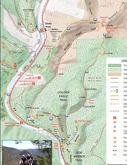
I met some friends from college to hike this excellent loop, totaling 10.3 miles. It follows the classic Golden Eagle Trail and the fairly new Dragon’s Back Trail featuring several views, rock outcrops, and cascades. It is considered one of the finest dayhikes in the state. I recommend adding the Dragon’s Back Trail as I feel it is more scenic than the Golden Eagle Trail along Bonnell Run, which is still very scenic with a gorge of open hardwood forests.
From the parking area, we crossed PA 414 and began on the GET as it climbed up a gorge. We turned right to begin the loop as falls tumbled below us to the left. We made the long climb up to the ridge, which steepened as we neared the top. It was getting warm and the sunlight filtered through the forest. We reached the ridge and enjoyed the breeze as we descended passing a fine view to the left that looked up Wolf Run and then shortly thereafter, the classic view from Raven’s Horn and its unique rock outcrop. The view was stunning as we looked into the Pine Creek Gorge as green mountains surrounded us.
Our descent continued along the ridge, passing more unique rock outcrops. The trail then followed Wolf Run, which was flowing low, but has many cascades and small falls in a deep gorge. We passed outcrops of flagstone, with sheaths of rock that looked stacked. The trail along the creek was beautiful, and we crossed it several times. When flowing well, Wolf Run is truly beautiful. As we neared the top, there was a an old growth forest of giant pine and hemlock. We reached our first view and then hiked through the laurel to an old forest road, which we took to Beulahland Vista, a gorgeous view looking over the fields and mountains of northern Pennsylvania.
We continued on the grassy road, passing another excellent view, Bonnell Run Vista. The GET then turned left, but we continued straight on the grassy forest road to hike the Dragon’s Back Trail. We soon entered the woods and followed the yellow blazes along the forested ridgeline that narrowed with steep slopes on both sides. We enjoyed another view, Webber’s Vista, looking down on Slate Run. We made another short climb, and then descended on a series of grades that switchbacked down to PA 414.
We crossed the road, walked down to the rail trail, and turned left on it. The rail trail had great views of Pine Creek, wildflowers, and even an old cemetery. It was a great way to end the hike. We reached our cars and went to Slate Run for a meal.
Pine Creek Gorge has dozens of excellent hiking trails for any ability. However, hiking here generally means climbing. The views make it more than worth it.
Parking is at 41.439008, -77.511436.
Scroll through the photos.
View this post on InstagramA post shared by Jeff Mitchell-Outdoors Author (@hiking_mitch)
View this post on InstagramA post shared by Jeff Mitchell-Outdoors Author (@hiking_mitch)
View this post on InstagramA post shared by Jeff Mitchell-Outdoors Author (@hiking_mitch)
July 12, 2021
Hiking at Erie Bluffs State Park
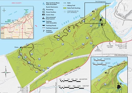
Erie Bluffs State Park is one of PA’s newest state parks, and surely one of its most unique. This park has a hiking experience unlike any other in the state. Imagine hiking with the sound of the surf, with views across Lake Erie, which may as well be a freshwater ocean. There is a beach, inlets, ravines, and trees of impressive size. The trails that exist here are far more extensive than what is shown on the map. I do not know if these trails are official. For the best hike, you should incorporate these trails (brown on the map). They often have some blazes, but not always, and are clearly established. They are also very curvy. They appear to primarily be used by mountain bikers. The hiking here is relatively easy, but you should be good with navigation to use the brown trails on the map above.
From the parking area, begin on the Transition Trail as it crosses fields with bird houses. There are also many wildflowers. The trail follows a woodline and reaches a four-way intersection. Turn right on the Lookout Trail as it follows the edge of the gorge and offers the first views of the giant hardwood trees that call this park home. Some of the trees here are gigantic, with oak, maple and tulip poplar. Erie Bluffs is the Cook Forest of hardwood trees. Reach another intersection; the view here is ok. Follow an unblazed trail down the slope to superb view of the lake from the top of the bluffs. The forests are unique at top of the bluffs; it is open with hardwoods. Be careful along the bluffs, as they are eroding. It is awesome to hike with sounds of the surf and views of the lake.
Follow the unblazed trail down to the Fisherman’s Foot Path and walk out onto the beach and inlet of Elk Creek. Enjoy the beautiful scenery. It is hard to believe you are in Pennsylvania. Retrace your steps back up to the Bluffs Edge Trail. Where that trail makes a sharp left, continue straight on an obvious trail. These trail meanders wildly, around ravines and back to the bluffs with some views. The scenery is unique, and the ravines are almost 100 feet deep. You may notice some different paint blazes on the trees, but the trails do not have signs. I tended to keep turning right to get to the bluffs, and then the trails would veer left to go around the ravines.
We then reached the Timber Trail and followed it for a while, passing more giant hardwoods and beautiful forests. We then turned right again for one of the most scenic parts of the hike as the trail followed the edge of a deep ravine, and then followed the top of the bluffs. It was beautiful with the wind, surf, and views. Next was the yellow West Overlook Trail along the edge of Duck Run’s ravine. We found a trail to drop into the ravine and it was stunning to walk down it with the creek and huge trees. We hiked to the shore with views of the lake and a small slide where Duck Run flowed into the lake. When it is calm, and the lake is low, it is possible to hike along the shore. I hear it is an amazing experience.
We hiked out along the Duck Run Trail, dropped back into the scenic ravine, and followed the Whitetail Crossing and Black Oak Savanna Trails, which crossed more fields and meadows with wildflowers. Next was a right turn on the Transition Trail back to the parking area.
This route was 8-9 miles long. Parking is at 42.015128, -80.376735. While in the area, visit famous Presque Isle State Park and the city of Erie, which has many breweries.
Scroll through the photos.
View this post on InstagramA post shared by Jeff Mitchell-Outdoors Author (@hiking_mitch)
View this post on InstagramA post shared by Jeff Mitchell-Outdoors Author (@hiking_mitch)
June 30, 2021
Hike the Toms Creek and Landis Lake Loop-Delaware Water Gap National Recreation Area
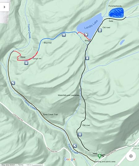
This is an enjoyable 4ish mile loop in the Delaware Water Gap National Recreation Area. It features cascades, streamside hiking, gorge rim, hemlocks, a beautiful lake and wetlands, and waterfalls when the creek is flowing well. It is a hike of great diversity, with many wildflowers, birds, and wildlife, especially near the lake and wetlands. This entire hike follows established trails, some are unblazed. This route is similar to that found on AllTrails, with some modifications.
From the Toms Creek picnic and parking area, walk to the back of the picnic area and pick up the obvious trail as it goes upstream with views of Toms Creek. It is an easy, gradual hike. There are cascades, boulders and pools in the creek. Large trees rise overhead, including tulip poplar and its distinctive blooms which had fallen to the forest floor. This official trail comes to an end at a bench with views of the creek. Now pick up the unblazed trail, which is obvious and goes upstream with more views of the creek and its cascades.
Begin a steep climb up the slope and the trail turns left, following the rim of the gorge with forested views looking down towards the creek. The forest has many hemlocks. Intercept a trail with blue blazes, follow it and cross a small stream. Go uphill. The trail levels off as it nears Landis Lake with many hemlocks and pines.
We lost the blue trail around a blow down. I believe it follows the dotted blue route on the map, but I did not hike that. A better way is to follow an unblazed trail that goes along the shore of the beautiful, serene lake. I felt as if I were in the Adirondacks. Enjoy the scenery, birds, and lilypad blooms. Landis Lake is a place where you’ll want to relax and enjoy. The unblazed trail soon reaches a bridge at the outlet of the lake. Reach an old road.
We turned left on the road to enjoy more views of the lake and many wildflowers. Reach a gate and hike around it, I believe this is now an open road to cars. We saw a large wetland with many dead, standing trees. On top was a heron nest, and a group of herons with the chicks, who looked too large for the nest. The adults flew away, their massive wings flapping, before disappearing over the trees and down to the Delaware River where they feed. It was a great experience to see these incredible birds. We went back to the footbridge at the outlet of Landis Lake.
Now we just followed the old road down, now largely covered by grass and vegetation. Wooden guardrails still accompany the road. We soon came upon a gorge with cascades and falls, some over twenty feet high. The creek was low, but when running well, these falls would be beautiful. The gorge looked deep and rugged, and I’m sure it hides more waterfalls. The old road meandered down the mountain, often under pine trees. We hiked around the gate, turned right on the road, and walked the short distance back to the parking area. Near the parking area, notice the giant European beech tree and its red leaves.
For the map above, brown is the official Toms Creek Trail, red are established but unblazed trails, blue is a blue blazed trail, black are old roads. The blue dotted route may be the AllTrails route near the lake. All routes are established, there is no bushwhacking. Enjoy this beautiful hike.
Parking is at 41.126645, -74.955010.
Scroll through the photos.
View this post on InstagramA post shared by Jeff Mitchell-Outdoors Author (@hiking_mitch)
View this post on InstagramA post shared by Jeff Mitchell-Outdoors Author (@hiking_mitch)
View this post on InstagramA post shared by Jeff Mitchell-Outdoors Author (@hiking_mitch)
June 29, 2021
Anders Run Natural Area-Cornplanter State Forest
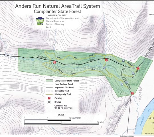
is a tiny gem in northwest Pennsylvania, adjacent to the massive Allegheny National Forest. It protects a valley that harbors an old growth forest, with towering pine trees. These trees are among the tallest in the eastern United States, and are over 400 years old. There is a yellow blazed trail system that explores the forest and valley.
On this hike, we did the small loop via the cross connector. This hike was less than a mile. The natural area is just 96 acres in size. Anders Run flows through the natural area, a small stream that is biodiverse; it is even home to lampreys.
From the main parking area, we followed the trail into the woods and the large pine trees soon came into view. Even larger trees were down the slope, almost out of view. The trail took us to a road, where we turned left, walking the road. More giant trees were along the road. The trail made a discreet turn right into the woods and we followed the yellow blazes, crossing some bridges. The cathedral of soaring trees was impressive as moss and ferns adorned the ground. Anders Run babbled softly to the left as it flowed under logs and into clear pools.
We decided to hike the cross connector and it was my favorite part. The trees were beautiful as they reached into the sky. It truly felt primeval. It was like Cook Forest State Park, just smaller in size. The cross connector trail crossed the road and we turned right onto the main loop. There were still some large pine trees as the trail went in and out of small drainages. Most of the trees were beech and other hardwoods. We soon returned to the car.
If you want a longer hike, just follow the main loop which is over two miles long. The trails were narrow and brushy in places, but were easy to follow.
If you’re looking for a short, easy and beautiful hike to do near the Allegheny National Forest, don’t miss Anders Run Natural Area.
Parking is at about 41.824727, -79.275683.
Scroll through the photos.
View this post on InstagramA post shared by Jeff Mitchell-Outdoors Author (@hiking_mitch)
June 24, 2021
Hike the Rimrock Loop/Morrison Trail-Allegheny National Forest
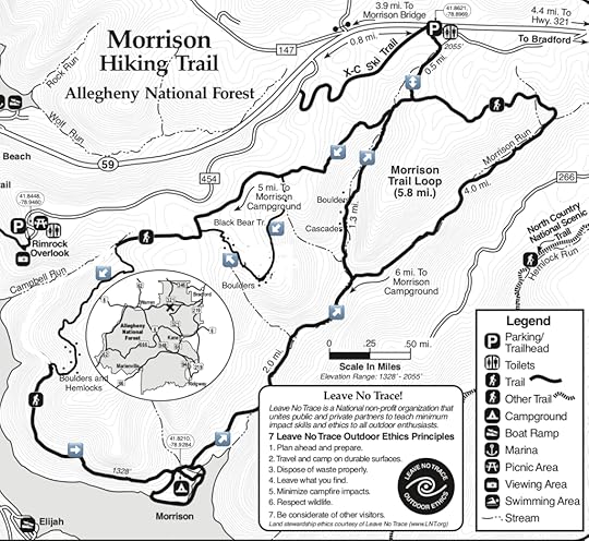
The Morrison Trail is one of the finest hikes in the Allegheny National Forest. It is a loop with a cross-connector, creating two loops. The longer of these loops is the Rimrock Loop. In recent years, the trail has been extensively rerouted in places, avoiding Campbell Run and some wet areas. Also a new side trail, the Black Bear Trail, has been added. Our hike followed the Rimrock Loop and Black Bear Trail, and was about fourteen miles long; longer than the maps would suggest. Further trail modifications may occur in the future.
The trails are well established, have signs at intersections, and are blazed with white or silver diamond placards. These trails are ideal as either a long dayhike, or short overnight backpack.
From the parking area, we followed a connector trail and turned left at the loop. The forests were mostly hardwoods with vast glades of ferns. We could see deep in the forest. As we descended, hemlocks became more common and we reached a small stream, and the cross connector trail. This was the start of the Rimrock Loop and we went right. Luckily, this was the peak blooms for mountain laurel and the pinkish white blossoms adorned the forest. It was beautiful. The trail was level and rolling through the laurel. We then reached the juncture with the new Black Bear Trail and turned left. The trail descended, passing groves of hemlocks and small streams. We then hiked among some large mossy boulders in open hardwood forests with ferns. The trail curved around the mountain, passing more boulders and then gradually climbing back to the Rimrock Loop. While Black Bear is nice, it is not a must-see, but is a great way to make a longer hike.
The new section of the Rimrock Loop soon began as we climbed through open hardwoods and then dropped over a rocky section. The trail continued a descent and entered a very scenic cove with large hemlocks and gigantic boulders with ferns, moss and lichens. Some giant boulders had entire forests growing on top. This was my favorite spot and I’d like to explore more of it. It felt primeval.
The trail returned to the open hardwoods and gradually descended to a side trail that leads to the Morrison Campground. The trails in this area are brushy, but still easy to follow. The only way to see the reservoir is at the campground, which is a nice place to take a break. There is a fee to camp here.
After the campground, the trail made its way up Morrison Run, another gorgeous section with great campsites, hemlocks, cascades and pools. The streamside hiking was a joy as trout darted in the pools.
At the next intersection, we turned left to begin the cross connector up a side stream of Morrison Run. This is another great trail with cascades, hemlocks, and more giant boulders. At one place, just off trail, the creek flows underground, beneath the mossy boulders with awesome rock formations, a cave, and cascades. One thing I love about the Allegheny National Forest are all the giant sandstone boulders.
We completed the loop and returned back to the car. Hopefully the national forest will continue to expand its hiking trails.
After your hike, be sure to check out the beautiful Rimrock Overlook, which is nearby. At the base of the cliffs, cold air blows out of the cracks in the rock in the summer.
Parking is at 41.861656, -78.896839. For the map above, black dots are boulders.
Scroll through the photos:
View this post on InstagramA post shared by Jeff Mitchell-Outdoors Author (@hiking_mitch)
View this post on InstagramA post shared by Jeff Mitchell-Outdoors Author (@hiking_mitch)
View this post on InstagramA post shared by Jeff Mitchell-Outdoors Author (@hiking_mitch)
View this post on InstagramA post shared by Jeff Mitchell-Outdoors Author (@hiking_mitch)
View this post on InstagramA post shared by Jeff Mitchell-Outdoors Author (@hiking_mitch)
June 8, 2021
Hike the Cliff Park/Raymondskill Loop-Delaware Water Gap National Recreation Area
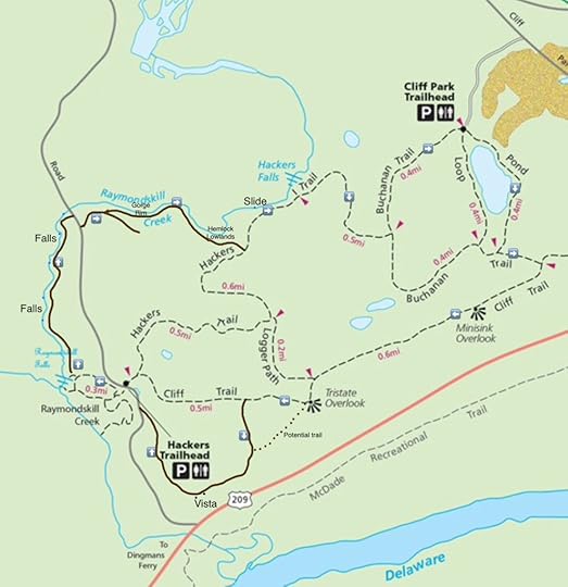
This loop is one of the most scenic in the Poconos, and all of eastern Pennsylvania. It features a beautiful pond, hemlock forests, views, cliffs, gorge, and a stunning array of waterfalls, including famous Raymondskill Falls. The loop is about 5-6 miles long and is moderate in difficulty. It follows trails, most of which are blazed. On the map above, the brown trails are established, but do not have signs or blazes. Some of these “brown” trails appear on the national park’s website. I highly recommend including the brown trails as they greatly enhance the scenery of this hike.
We began from the Cliff Park trailhead as it has more parking than the Hackers Trailhead at Raymondskill Falls. Follow the Pond Loop to the left and enjoy views of the scenic pond with wooded hillsides. Climb gradually along an old grade and then turn left onto Buchanan Trail, heading towards Cliff Trail. On our hike, this part was closed due to nesting peregrine falcons, but is the recommended route if open.
Turn right onto Cliff Trail and hike along the ridge on top of the cliffs, enjoy Minisink Overlook and then Tristate Overlook, offering great views of the Delaware River valley and the Kittatinny Ridge in New Jersey. When the leaves are off the trees, the views are extensive. These cliffs are huge, so be very careful around them. At Tristate Overlook, notice an obvious, unmarked trail heading south along the ridge. We did not hike it, but it may be a shortcut for this route.
Follow the Cliff Trail downhill on an old grade, and notice an obvious grade ascending to the left. Climb up it, it is not signed or blazed. Reach the top and follow a trail down and to the right along the top of the ridge and cliffs. Reach awesome views looking south down the Delaware River. Follow the unmarked trail along the ridge and descend gradually to the road. Follow the road up to the parking area for Raymondskill Falls. Enjoy the views of this amazing falls, one of Pennsylvania’s tallest and hike to the top of the falls. Look for an unblazed trail heading upstream, follow it.
This trail is incredible as it explores stunning bedrock grottos, gorges, and many falls, slides, pools and cascades. The forest is mostly hemlock. The tallest falls is over forty feet. Whitewater kayakers often paddle this section of the creek when the water is high. Work your way up along the creek, enjoying the incredible scenery. This trail seems well-known as we passed other hikers. Reach the road again and turn right. Look for an old forest road to the left and follow it. This old forest road curves right and climbs gradually. Look for an established trail to the left that descends, follow it. Hike on top of the rim of a gorge with hemlocks, as Raymondskill Creek flows below. The scenery is beautiful. Descend to what I call the hemlock lowlands along the creek; the hemlock forest here is a joy to explore. The trail leaves the creek and climbs gradually, ending at the Hackers Trail. Turn left.
The Hackers Trail climbs slightly; a side trail to the left leads to an impressive slide and rock outcrop. Continue on the Hackers Trail to impressive Hackers Falls and its deep pool. There is so much scenery along this loop. Climb to the Buchanan Trail and turn left onto it. Follow this trail with pine trees, meadows, and abandoned buildings back to the parking area.
The Delaware Water Gap National Recreation Area is Pennsylvania’s largest and one of its most popular national park properties. It is an amazing place, with stunning gorges, waterfalls, vistas, ponds, and rock outcrops. This is the website of the Cliff Park trails.
Again, the brown trails on the map above are not signed or blazed. However, they are well established and easy to follow.
Parking at Cliff Park Trailhead is at 41.303798, -74.832765. Hackers Trailhead/Raymondskill Falls is at 41.290197, -74.841145.
View this post on InstagramA post shared by Jeff Mitchell-Outdoors Author (@hiking_mitch)
View this post on InstagramA post shared by Jeff Mitchell-Outdoors Author (@hiking_mitch)
View this post on InstagramA post shared by Jeff Mitchell-Outdoors Author (@hiking_mitch)
View this post on InstagramA post shared by Jeff Mitchell-Outdoors Author (@hiking_mitch)
View this post on InstagramA post shared by Jeff Mitchell-Outdoors Author (@hiking_mitch)
June 4, 2021
Hike the Dutters Run/Old Bark Loop-Loyalsock State Forest
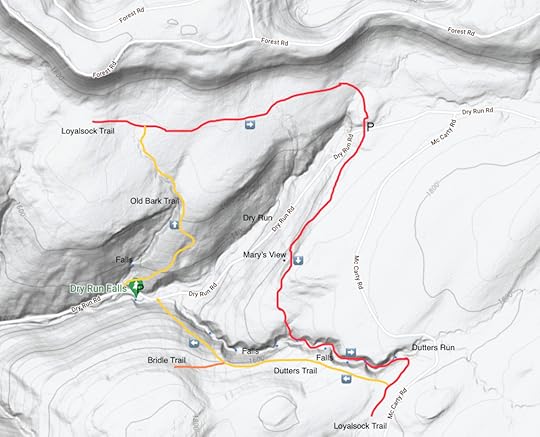
Over the last several years, the Loyalsock State Forest has become a popular hiking destination with its diverse and beautiful scenery. This loop is 4.5 mile long and moderate in difficulty. There are several waterfalls, a nice view, a gorge, spring wildflowers, and open forests with glades of ferns. I think it’s best to park at Dry Run Falls, a great way to both begin and end the hike.
From Dry Run Falls, walk down the road and turn right onto Old Bark Trail, blazed yellow and climb on an old forest road. The creek to your left has a great fifteen foot falls, but it is off the trail. To reach it, hike up the creek. When flowing well, you should not miss this falls. The trail gradually climbs and moves towards the small creek. Cross some wet areas and fern meadows. Reach the Loyalsock Trail (LT). Turn right onto the LT. This part of the trail has some wet spots and features hardwood forests with some towering trees. Cross the headwaters of Dry Run, some campsites, and reach the parking area on Dry Run Road. Continue on the LT and cross the road.
The trail passes through the woods and reaches Mary’s Vista, a narrow window of Dry Run Gorge. It offers a great view of Smith’s Knob and the mountains to the west. Begin to drop down into Dutters Run with some rocky terrain. Reach Dutters Run with a small waterfall. There are larger waterfalls downstream, but they are off trail. The LT meanders up the narrow, wooded gorge of Dutters Run, a highlight of the hike. There are many cascades and falls, and stream crossings without bridges, expect about seven of them. The tallest falls is about 12 feet. Enjoy your time along Dutters Run, it is a beautiful place.
Pass a small cascade and campsite, and climb out of the gorge, following the LT. Turn right onto the yellow Dutters Trail. Descend along an old grade through the woods and pass a juncture with a bridle trail to the left. The trail moves closer to the edge of the gorge and you can see some of the higher falls below; these falls are off trail. Descend to Dry Run Road and turn left back to Dry Run Falls. Ten years ago, Old Bark and Dutters Trail hardly existed. Now they are well established. Hiking has skyrocketed in the Loyalsock. With beautiful loops like this, it is easy to see why.
Afterwards we drove to enjoy the incredible views from High Knob, and to the Hillsgrove Covered Bridge. The Loyalsock is a special place.
Parking at Dry Run Falls is at 41.430370, -76.670430. LT parking is at 41.438448, -76.653757.
Photos:
https://www.instagram.com/p/CPjsW2XN7zM/?utm_source=ig_web_copy_linkhttps://www.instagram.com/p/CPjs48mNocm/?utm_source=ig_web_copy_linkhttps://www.instagram.com/p/CPmVryzt5EG/?utm_source=ig_web_copy_linkhttps://www.instagram.com/p/CPl5C7ENJjq/?utm_source=ig_web_copy_linkJeff Mitchell's Blog
- Jeff Mitchell's profile
- 3 followers


