Jeff Mitchell's Blog, page 10
April 11, 2023
Explore the Pinchot Brook Waterfalls-Delaware State Forest
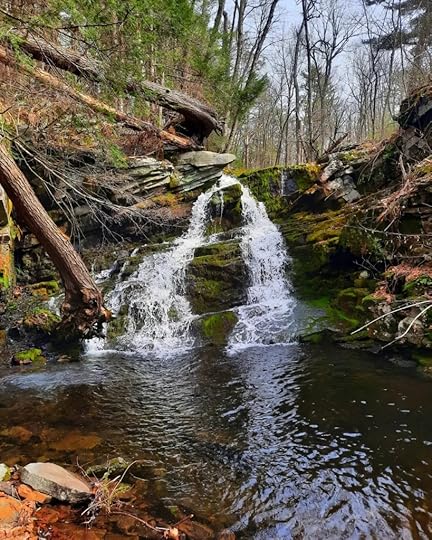 Slanted Falls, Pinchot Brook
Length: less than a mile
Blazes: this hike is completely off trail, there are no blazes or signs
Parking: 41.356149, -74.850831
Difficulty: Moderate
Highlights: Several beautiful waterfalls, cascades and pools
Description: The Poconos are famous for its many waterfalls. However, the waterfalls on Pinchot Brook appear to be unknown. This is surprising because this creek has a beautiful collection of waterfalls and cascades that are continuous for almost a quarter mile. This hike is in the Delaware State Forest.
From the parking area, head east into the woods. The woods are mostly open with only some low brush. Descend to Pinchot Brook and hike up it. First notice a series of moss covered step cascades, these are the Moss Steps. One highlight of Pinchot Brook is the incredible amount of moss that covers the stream bed. Continue up the creek to Slanted Falls, probably the tallest at about 15 feet. The underlying bedrock has slanted layers. Below the falls is a deep pool.
Above are more cascades, slides and another falls. Moss carpets the bedrock. There are deep pools eroded into the bedrock. This is a very scenic stream. Enjoy the cascading water. At the top is a final falls and then the stream levels off. Here, turn west back to the parking area to complete the loop.
Sawkill and Savantine Falls are nearby, and do not miss Lilly Pond which is just up the road.
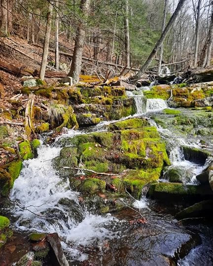 Moss Steps, Pinchot Brook
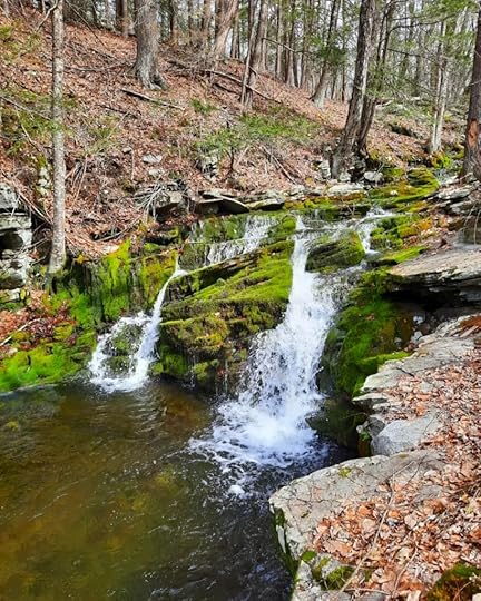 Pinchot Brook, Delaware State Forest
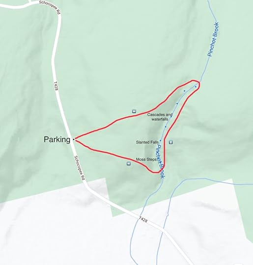 This map is for general directional purposes only, it is not a GPS track. Red is the off trail route.
More photos:
View this post on InstagramA post shared by Jeff Mitchell-Outdoors Author (@hiking_mitch)
View this post on InstagramA post shared by Jeff Mitchell-Outdoors Author (@hiking_mitch)
March 22, 2023
Backpacking the Loyalsock Trail
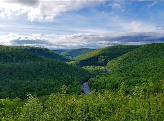 Canyon Vista, Worlds End State Park
The Loyalsock Trail (LT) is one of the finest backpacking trails in the Mid Atlantic, if not the northeast. It is a classic Pennsylvania backpacking trail. The LT was first established in 1951, making it one of the older backpacking trails in the country. The trail is known for its challenging terrain and diverse scenery, with many waterfalls, scenic streams, views, gorges, large rocks, hemlock forests, a pond, historic features, and great campsites. Thruhiking the LT will be an experience you won’t forget and is a perfect prep hike for longer trails, like the Long Trail or Appalachian Trail.
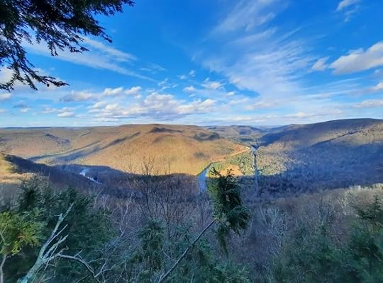 Smiths Knob
Length: 59.2 mile linear trail
Maintained and managed by: Alpine Club of Williamsport
Trail guide and maps: available for sale from the Alpine Club of Williamsport
Permits: None for parking or backpack camping if staying at a site for only a night. Large backpacking groups may need a permit, contact the Loyalsock State Forest. It can be a good idea to let the Loyalsock State Forest know where you are parked at, the state forest does have patrolling rangers.
Cell service: Spotty, service can sometimes be found on high ridges.
Campfires: Are not permitted at the Haystack Rapids and can be restricted along the entire trail at other times of the year. Contact the Loyalsock State Forest.
Blazes: Yellow with a red “LT”. Old paint blazes are being replaced with small disks.
Days to hike: 3-7 days.
Difficulty: The LT is known as a difficult trail with many climbs, steep terrain, and streams without bridges.
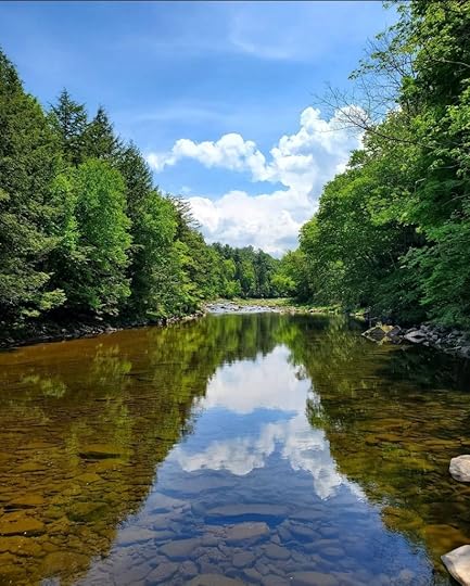 Loyalsock Creek
Direction of hiking: Most hikers go from west to east. I went the opposite. I think the trail is a little easier that way and saves some of the best views for the end of the hike. If you prefer steep climbs, hike east. If you prefer steep descents, hike west.
Eastern trailhead: There is a large parking area on Mead Road. 41.447717, -76.453478
Western trailhead: There is a small pull off parking area along PA 87. 41.361361, -76.877028
Other trailheads: Worlds End State Park office: 41.471771, -76.581766
Rock Run Road: 41.459713, -76.509704
Worlds End Road: 41.451092, -76.601897
Dry Run Road: 41.438049, -76.655404
Little Bear Creek Road: 41.355636, -76.859320
Brunnerdale Road: 41.385229, -76.668259
Shuttle information: this is shuttle information from the Alpine Club of Williamsport
Shelters: None.
Water: Generally plentiful. Trail can be dry between Ogdonia Creek and Hessler Branch or Grandad Run. The western part of the trail, from PA 87 to Brunnerdale Road is generally drier.
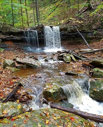 Dutters Run Falls
Resupply: There are no readily available places to resupply on the trail. There is a seasonal snack bar open in Worlds End State Park. Highland Lake Manor is along the trail and is a restaurant for a private club, I do not know if it is open to the public. An ideal place to cache food is along Dry Run Road.
Amenities: Worlds End State Park office has a modern restroom and running water.
Side hikes not to be missed: High Knob Overlook, Angel Falls, Dutchman Falls.
Ideal time to hike: Fall colors are usually peak in mid October. Mountain laurel is common along the trail and blooms in mid to late June.
Stream crossings: Outside of Worlds End State Park, there are no bridges across streams. In high water, this is a problem. The largest stream crossing is Kettle Creek, about 20-30 feet across.
Other issues: Stinging nettle is an issue on sections of the trail in summer.
Trail running: The LT and connecting trails host a couple of trail run races every year. These trail races are very popular. It is worth checking when those races are scheduled as you’re planning your hike.
Highlights: Dutchman Falls, Haystacks Rapids, Sones Pond, Alpine Falls, Worlds End State Park, Canyon Vista, Mineral Springs Falls, Alpine Vista, Lower Alpine Vista, Ketchum Run, Rode Falls, Lee’s Falls, Split Rock, Dutters Run, Kettle Creek Gorge, Angel Falls, historic structures near Highland Lake, Smith’s Knob, Allegheny Front.
Other websites: Loyalsock State Forest, Worlds End State Park
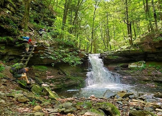 Rode Falls, Ketchum Run
Map legend: C= campsite or potential camping. P= parking. V= vista. Black dots are large rocks. Blue dots are waterfalls or cascades.
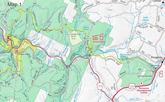
Map 1- Eastern Terminus (Mead Road) to Worlds End State Park Office (13 miles)
This description is east to west. From the Mead Road trailhead, the LT makes a rocky descent to an old railroad grade and turns left on the grade. A blue side trail to the right descends to the bottom of Dutchman Falls. The LT follows the grade, then makes a somewhat discreet right turn off of it. Descend to the Loyalsock Creek for some beautiful hiking. The creek is beautiful. Reach the stunning Haystacks Rapids with several superb campsites. Fires are not permitted here. The rapids are ideal for swimming in summer and can be busy on weekends.
The LT climbs steeply back to the grade at a seasonal waterfall. Follow the grade and then leave it, descending to Rock Run Road. At the road, the Link Trail joins; there is good camping a short distance down the Link Trail. Cross the bridge and follow the road. The LT turns to the right and climbs up a glen with some rock outcrops. Reach the top with large boulders and ledges. Cross a forest road and reach beautiful Sones Pond with excellent camping. Hike through beautiful hemlock forests.
Pass a rock outcrop known as Porky’s Den due to the porcupines that live there. Cross Tamarack Run. Rolling terrain through scenic forests of hemlocks and northern hardwoods follow. Descend to Big Run and take the short side trail to Alpine Falls in a grotto of cliffs. Camping is downstream. Climb out of Big Run and follow an old grade, camping is available well below the trail near the creek. Pass through hemlocks and continue through the woods, sections of this trail can be wet. Begin the descent of High Rock Run with small cascades. Pass a fine campsite above a waterfall. Enter Worlds End State Park (backpack camping is not allowed in the state park) and reach High Rock Vista. Climb from the vista and then make a very steep, rocky descent to High Rock Run; High Rock Falls is below. Hike to the park office.
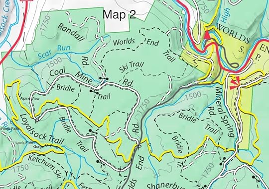
Map 2- Worlds End State Park Office to Ketchum Run (13 miles)
Cross PA 154 and begin a long climb. Reach another view of Worlds End and turn left onto Pioneer Road, a historic road and the first built through the Loyalsock Canyon. Descend to Double Run with cascades; upstream on Double Run Trail is Cottonwood Falls, a worthy side trip. Cross both branches of Double Run and begin a climb among boulders. The trail levels, but then makes a more gradual climb, passing rock outcrops. Reach the top and hike among giant boulders. Reach stunning Canyon Vista. The trail is rolling to Mineral Spring Falls. Descend and then climb again, passing some giant rocks. The climb continues, and then begins a descent to the west branch of Double Run with camping and hemlocks.
Cross Worlds End Road and continue a climb near a spruce forest. Enjoy beautiful hemlock forests. Reach Alpine Vista with a dry campsite, a steep descent brings you to the equally beautiful Lower Alpine Vista. The views are excellent. Descend to a highlight of the trail, gorgeous Ketchum Run. Reach Rode Falls and climb the ladder next to the falls. Climb to the rim of the gorge and then descend to Lee’s Falls. Hike into a stunning mini-gorge with cascades. Continue up Ketchum Run with fine camping.
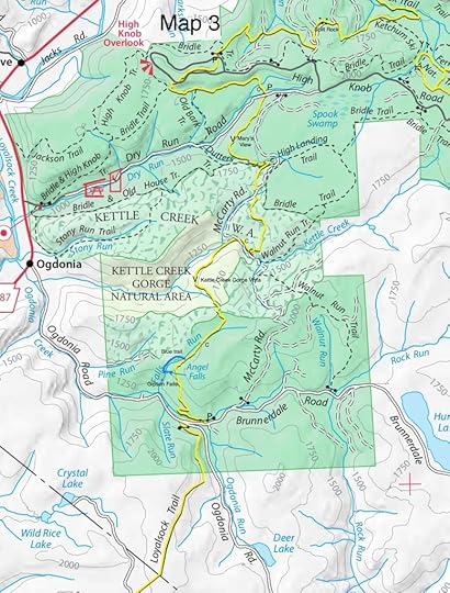
Map 3- Ketchum Run to Brunnerdale Road (12 miles)
Cross Ketchum Run (two more falls are upstream, off trail) and climb to Split Rock, which are giant boulders. Descend to Cape Run with cascades and falls. Climb again and cross the loop road to High Knob Overlook, a worthy side hike.
Descend steeply and hike rolling terrain which can often be wet. Pass a campsite and cross Dry Run Road. The trail passes Mary’s View and then descends to Dutters Run with several falls and stream crossings. The gorge is very scenic. Pass a fine campsite and then climb out of the gorge through large hardwood trees, particularly tulip poplar. Descend steeply to Kettle Creek, another highlight. I love Kettle Creek, it is the most isolated area of the LT with cascades and some great camping. Cross the creek, the largest stream crossing on the trail.
Climb to Kettle Creek Gorge Vista, a beautiful view. Climb out of the gorge and then descend to Falls Run with possible camping. Don’t miss the blue side trail to Angel Falls, the tallest on the LT at about 70 feet tall. If flowing well, it is impressive. Downstream is Gipson Falls. The LT descends to and crosses Brunnderdale Run and then crosses Brunnerdale Road. A long gradual climb follows.
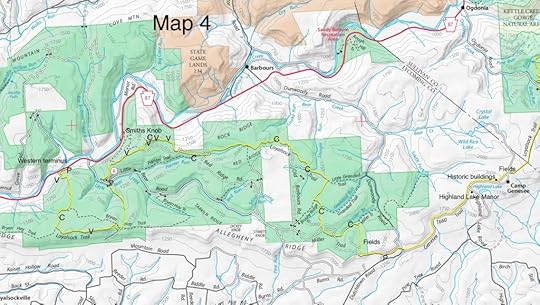
Map 4- Brunnerdale Road to Western Terminus (PA 87) (22 miles)
The LT enters private land, camping is not permitted for over six miles and there is about a 5 mile roadwalk. Follow an old forest road and then a dirt road with many fields and meadows. It reminded me of the Appalachian Trail in Virginia. An old cemetery is just off trail. Pass historic buildings from when this area was a resort. The Wind Whistle Inn was the casino of a nearby hotel, now gone. Through this area the LT follows roads, but leaves, following old grades, and then rejoins the roads. The LT passes the Highlands Manor restaurant. Descend on the road. The trail leaves the road to the right, climbs, then enters a glen with a small stream. Climb steeply, the trail levels, crosses a road, and then climbs again to return to the Loyalsock State Forest. Reach the top and then hike along scenic meadows with pine trees. Reach Hessler Branch with camping and water.
Important: the trail can be dry between Ogdonia Creek and Hessler Branch. This is also the road walk section. There is no camping on this section for over six miles, and there can be almost nine miles between water sources, depending on conditions.
From Hessler Branch, the LT climbs and descends between drainages. The creeks have pine and hemlocks, while the ridges in between have hardwoods, oaks, and mountain laurel. The LT passes Shingle Run and then a steep descent and ascent through Snake Run. Descend gradually along Little Painter Run and then climb up to another LT highlight, Smiths Knob. Enjoy three views, the best looks east up the Loyalsock Creek with dry camping. The trail is steep, levels and passes Helen’s Window, another great view. A steep descent continues to a parking area on Little Bear Creek Road.
Now climb up Pete’s Hollow with cascades and rocky terrain. Climb to the Allegheny Front, with one superb view. This area of the trail will be impacted by a pipeline and may be rerouted. Hike along the ridge and then descend. The trail levels with hemlocks and small streams. Hike among laurel and then make the final, challenging and very steep descent over rocks and boulders. Pass Sock Rock and a final view. The trail becomes even steeper as you descend a ledge. The LT levels and then drops down to PA 87 and the western terminus.
More photos:
View this post on InstagramA post shared by Jeff Mitchell-Outdoors Author (@hiking_mitch)
View this post on InstagramA post shared by Jeff Mitchell-Outdoors Author (@hiking_mitch)
View this post on InstagramA post shared by Jeff Mitchell-Outdoors Author (@hiking_mitch)
View this post on InstagramA post shared by Jeff Mitchell-Outdoors Author (@hiking_mitch)
View this post on InstagramA post shared by Jeff Mitchell-Outdoors Author (@hiking_mitch)
View this post on InstagramA post shared by Jeff Mitchell-Outdoors Author (@hiking_mitch)
View this post on InstagramA post shared by Jeff Mitchell-Outdoors Author (@hiking_mitch)
View this post on InstagramA post shared by Jeff Mitchell-Outdoors Author (@hiking_mitch)
View this post on InstagramA post shared by Jeff Mitchell-Outdoors Author (@hiking_mitch)
View this post on InstagramA post shared by Jeff Mitchell-Outdoors Author (@hiking_mitch)
View this post on InstagramA post shared by Jeff Mitchell-Outdoors Author (@hiking_mitch)
March 10, 2023
Hike at Lyman Run State Park
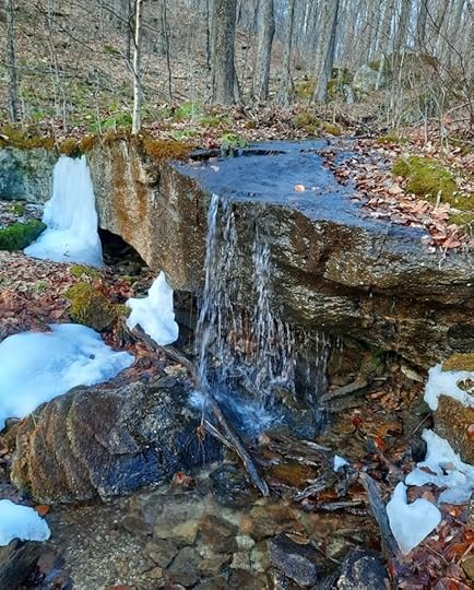 Cascade on the Beehive Trail
Length: Approx. 3.5 to 4 miles
Highlights: Lyman Lake, streamside hiking, large rocks, view, cascades, hemlock forests
Difficulty: Moderate.
Issues: No bridge on the Lyman Run Trail
Parking: 41.724853, -77.760514
Description: Lyman Run is a beautiful state park. It is the perfect basecamp to explore the vast Susquehanna State Forest or the PA Wilds. Galeton is nearby and is located in a scenic setting, with a lake surrounded by mountains.
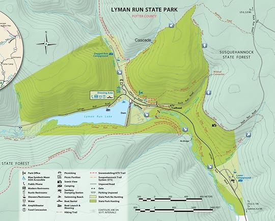
There are many trails at Lyman Run. The highlight of the park is Lyman Lake. This hike is a loop that begins and ends at the parking area near the dam spillway. There are other places to park.
From the parking area, follow the road above the creek, and then descend down to Lyman Run on the Lyman Run Trail. The trail along and near the creek is very scenic with hemlocks. Cross a bridge and continue down the Lyman Run Trail. Cross Lyman Run without a bridge, this would be a serious issue in high water. Continue along the creek and reach Lyman Run Road. Turn left on the road and then right onto the Rock Run Trail.
Follow the Rock Run Trail on a steady climb. Large boulders begin to adorn the forest and cascades are off the trail to the right. The trail then crosses Rock Run with small cascades and soon reaches Rock Run Road, follow it to the left. Reach the view as it overlooks the park and lake. Continue on the road and begin to follow the Wildcat Trail on a steady climb with more cascades and large boulders. At the top, hike under hemlocks.
Turn left onto the Beehive Trail and explore beautiful hemlock forests. Descend into a scenic glen and pass a 5-6 foot cascade over a boulder. Reach the camping area. Turn left on the road and follow the road to the lake and parking area at the dam.
More photos:
View this post on InstagramA post shared by Jeff Mitchell-Outdoors Author (@hiking_mitch)
View this post on InstagramA post shared by Jeff Mitchell-Outdoors Author (@hiking_mitch)
View this post on InstagramA post shared by Jeff Mitchell-Outdoors Author (@hiking_mitch)
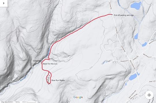
Hike to Blue Run Rocks-Tioga State Forest
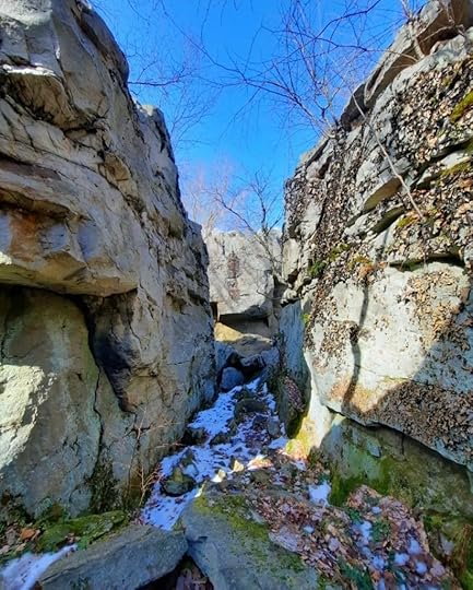 Blue Run Rocks
Length: About 1.9 miles, one way
Difficulty: Moderate
Highlights: Giant sandstone boulders with chasms, creekside hiking
Blazes: Red
Issues: Blazes becomes sporadic on climb up to the boulders, turn up to the boulders can be easy to miss. Blazes also sporadic around the boulders, particularly the west side of the loop.
Parking: Pull off parking is at about 41.818924, -77.529522.
Description: If you like giant rocks, this is the hike for you. Blue Run Rocks are over forty feet tall with chasms. These rocks also attract climbers. This hike also features a scenic stream, hemlocks and pines, and good isolation. This is not a particularly popular hike, so you will likely be alone.
The trail is in “followable” condition. However, the trail up to and around the rocks have sporadic to non-existent blazing, although there are trails to follow.
From the road, follow the level trail with scenic forests of beech, pine and hemlock. Begin a gradual descent along a creek, which is often in view. Hemlocks often grow over the trail. The trail crosses a side stream. Continue the gradual descent, but keep an eye out for a campsite along the creek below. This marks where the trail turns left and begins to climb. This turn can be easy to miss. The climb is somewhat steep and will get your heart pumping, but it is not very long. Reach the top with mountain laurel, pass another campsite, and descend to the bottom of the rocks.
Take your time exploring these giant outcrops. You can go in between and around some of the boulders. It is a beautiful place and used by rock climbers.
The trail goes around the base of the rocks, but the blazes became non-existent. We were able to follow the trail due to the cut logs on the forest floor. We completed the mini-loop and retraced our steps.
More info about Blue Run Rocks on MyHikes.
More photos:
View this post on InstagramA post shared by Jeff Mitchell-Outdoors Author (@hiking_mitch)
View this post on InstagramA post shared by Jeff Mitchell-Outdoors Author (@hiking_mitch)
February 17, 2023
Hike the Coal Run/Loyalsock Loop
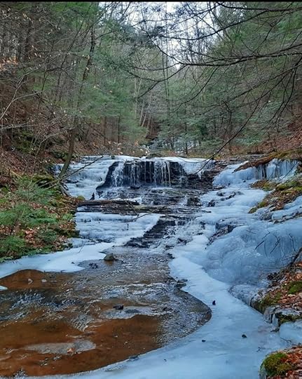 Coal Run, Loyalsock State Forest
Length: about 3 miles
Parking: Lot located at 41.459687, -76.509650
Blazes: only the Loyalsock Trail is blazed, yellow and red.
Highlights: beautiful gorge with waterfalls, Sones Pond, large rocks, Loyalsock Creek.
Issues: To complete the loop, you must follow unblazed trails, and off trail hiking up Coal Run. Hiking up Coal Run is difficult.
Difficulty: moderate to challenging
Description: This short loop packs in a lot of scenery and features one of the Loyalsock State Forest’s hidden waterfall gems- Coal Run. Keep in mind that Coal Run is a small stream, so it is likely a trickle in summer or dry periods. This hike is featured in Hiking the Endless Mountains.
From the parking area, hike across the bridge on Rock Run Road. Begin to climb. Where the road turns right, look for an unblazed grade to the left. Follow it. You may notice a faint path. At a Y in the grade, go right. Reach Coal Run. Now you must hike up Coal Run, after a small cascade, hike over the rocks and fallen trees. The gorge begins to narrow and the scenery really improves. Reach beautiful falls and cascades with giant boulders, my favorite spot. From here, the cascades and falls are nonstop, so enjoy the scenery. On this hike, I stayed on the right bank heading up. Hiking up Coal Run is the most challenging part of the hike, but completely worth it.
The two tallest falls are at the top and are twenty or more feet tall. Scale the steep bank to bypass them. Rock Run Road is nearby, follow it. Make the next left onto Loyalsock Road, reach Sones Pond with a parking area and bathroom.
Sones Pond is gorgeous. Notice an unmarked path on the east shore as it tunnels through brush. Follow it. The forest becomes beautiful hemlocks with moss. Reach the Loyalsock Trail (LT) and turn right. The rest of the hike follows the LT.
Hike up to and cross Rock Run Road and then explore hardwood forests on old grades. The trail then drops down among giant rocks and ledges. Level off and then drop down in the glen of a small creek with cascades. Turn right on a forest road and then left onto Rock Run Road. Retrace your steps back to the car. This is just one of many beautiful hikes in the Loyalsock State Forest.
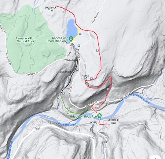 Green is an unblazed grade. Brown is off trail. Yellow is an unblazed path. Red is the Loyalsock Trail. This map is for general directional purposes only and is not a GPS route.
More photos:
View this post on InstagramA post shared by Jeff Mitchell-Outdoors Author (@hiking_mitch)
View this post on InstagramA post shared by Jeff Mitchell-Outdoors Author (@hiking_mitch)
February 6, 2023
Hike the Haystacks and Brook Kedron Loop-Loyalsock State Forest
Length: about 6 miles
Difficulty: moderate
Blazes: the Loyalsock Trail is yellow/red, Brook Kedron and Old Dushore Rd trails are yellow.
Parking: Loyalsock Trail parking (where this description begins)
41.447723, -76.453477. Loyalsock State Forest headquarters: 41.438754, -76.464071
Highlights: Dutchman Falls, Haystack Rapids, Loyalsock Creek, hemlock forests, Brook Kedron, cascades, falls, glen.
Issues: to see the full beauty of Brook Kedron, you must go off trail along the creek.
Description: The Haystacks have long been one of the most popular hikes in the Loyalsock State Forest. Now you can extend your hike on an even longer loop by using the Brook Kedron and Old Dushore Road trails. This is a great hike, especially if you go off trail to explore Brook Kedron.
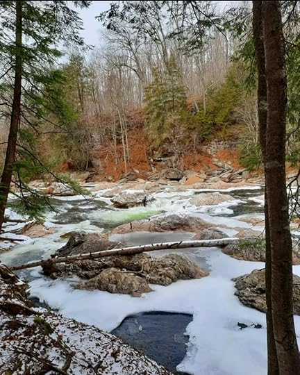
From the Loyalsock Trail (LT) parking area on Mead Road, follow the LT down a steep, rocky slope. Reach an old railroad grade. Off to your right is the blue blazed trail down to Dutchman Falls. It is worth your while to see this scenic falls. Follow the LT on the old grade. The trail turns right off of the grade, this turn can be easy to miss. Descend to the Loyalsock Creek with its rapids and pools. At times the trail is right next to the creek. It is beautiful hiking.
Move away from the creek, climb and then descend. Reach the Haystacks and enjoy this stunning setting with the smooth boulders, rapids and pools. Take a break and enjoy your time here. The LT makes a steep climb back up to the railroad grade at a seasonal falls with ice flows in winter. Now turn left onto the railroad grade, the Red X Trail. The grade is impressive as it cuts through the rock. Birch grows along the grade. Reach the yellow Brook Kedron Trail, there is a sign. Turn right and climb the trail. The trail veers left, and then right. Here, you might want to go off trail to your right on an old grade. Unfortunately, the Brook Kedron Trail avoids the beauty of its namesake so you will need to go off trail to see it. Hike under hemlocks and on top of some large boulders. Reach Brook Kedron and hike upstream. Enjoy the cascades and scenery. Enter Kedron Glen, a unique spot with fractured and layered bedrock along the ledges. Cascades and slides adorn the creek, with a falls about ten feet tall. A mini glen is just above. This off trail trek is fairly easy and very much worth it.
Look left and you should see the yellow blazes of the trail on an old grade. There is one more spot you need to see just off trail. It is The Bend and it features Brook Kedron making a sharp angle under hemlocks where you can look up and down the creek.
Return to the Brook Kedron Trail as it crosses Mead Road and explores scenic forests of hardwoods and hemlocks with blueberries and small meadows. Reach a deer fence, turn right and then the Loyalsock State Forest office comes into view. This is another place to park.
Continue on the yellow trail, now the Old Dushore Road. Hike along the deer fence and enter scenic forests of hemlocks. Cross a swath and descend under more hemlocks; US 220 is below. Reach Mead Road. Turn left and walk up the road to the parking area.
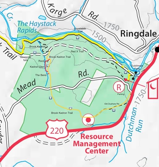 This map is not a GPS track and is for general directional purposes only. Red route is off trail. Blue dots are cascades and falls.
Photos and videos:
View this post on InstagramA post shared by Jeff Mitchell-Outdoors Author (@hiking_mitch)
View this post on InstagramA post shared by Jeff Mitchell-Outdoors Author (@hiking_mitch)
View this post on InstagramA post shared by Jeff Mitchell-Outdoors Author (@hiking_mitch)
View this post on InstagramA post shared by Jeff Mitchell-Outdoors Author (@hiking_mitch)
View this post on InstagramA post shared by Jeff Mitchell-Outdoors Author (@hiking_mitch)
View this post on InstagramA post shared by Jeff Mitchell-Outdoors Author (@hiking_mitch)
January 31, 2023
Hike Cheryl’s Trail-Loyalsock State Forest
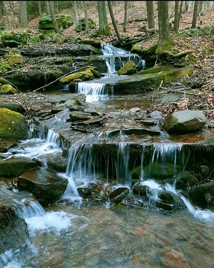
Length: About 1.5 miles one way (this hike is from the Jacoby Falls trailhead to the Pipeline Vista)
Blazes: Blue
Parking: 41.376762, -76.920109. Jacoby Falls trailhead.
Highlights: View, cascades, meadow, beaver pond, hemlock forests, unique rocks
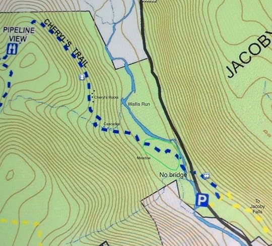
Issues: The trail is lightly hiked and may not be well established. There is no bridge across Wallis Run, a sizeable creek. Blazes are hard to follow in places, particularly the meadow which will be overgrown in summer.
Difficultly: moderate
Description: Cheryl’s Trail goes from Rider Park to Jacoby Falls, but this hike is only at the northern end of that trail. While plenty of people hike to Jacoby Falls, most ignore the sign for Cheryl’s Trail. That’s too bad, because this is a fun hike with some challenges along the way. It is a true diamond in the rough. In fact, overall, I think this hike is more fun and diverse than Jacoby Falls.
From the parking area, cross the boardwalk and enter the woods. Turn left onto the blue Cheryl’s Trail. As you will immediately see, this trail is not well established and the blazes are far apart in places, but they are there. Hike under the pine trees and descend back to the road. Cross the road.
Now you are faced with the first challenge, crossing Wallis Run. Expect your feet to get wet as it is a sizeable creek. Do not attempt in high water. Reach the other side and notice some beaver ponds and dams to the left. Now is the second challenge, the meadow. There are blazes on posts, but expect this to be overgrown in summer. On the plus side, enjoy the wildflowers. To cross the meadow, stay on top of the bank above the floodplain; this might be an old grade. Enter the woods with some large ironwood trees and then enter a scenic pine and hemlock forest. Again, blazes are a bit hard to follow, but there is more of a tread here. The trail angles right and then turns left on an old grade.
Hike into a glen with a beautiful series of small falls and cascades over mossy bedrock. The trail crosses the creek and climbs. I did hike up this creek, off trail on an old grade, it was scenic with many cascades. There was also a large ledge with a porcupine cave.
Back on Cheryl’s Trail, climb until the trail levels in a hemlock forest. Notice rock outcrops to your right. These are what I call Cheryl’s Rocks and they are the highlight of the hike. Go off trail and explore them from the bottom. There are overhangs, chasms, grottos, and caves. The rocks are very colorful with moss and lichen. In one cave, there are springs dripping, it must be an amazing place when frozen. These are some of the most beautiful rock ledges in the Loyalsock State Forest.
Back on the trail, follow a grade in a beautiful hemlock forest. The trail is much easier to follow. Ascend gradually and then level again under hemlocks. Reach the pipeline swath and enjoy the view. A better view is further up the bank on the pipeline swath. Retrace your steps.
The trails on Blessing Mountain between Rider Park and Jacoby Falls can use more footsteps to help keep them open, so please hike there.
More photos:
View this post on InstagramA post shared by Jeff Mitchell-Outdoors Author (@hiking_mitch)
View this post on InstagramA post shared by Jeff Mitchell-Outdoors Author (@hiking_mitch)
View this post on InstagramA post shared by Jeff Mitchell-Outdoors Author (@hiking_mitch)
View this post on InstagramA post shared by Jeff Mitchell-Outdoors Author (@hiking_mitch)
View this post on InstagramA post shared by Jeff Mitchell-Outdoors Author (@hiking_mitch)
View this post on InstagramA post shared by Jeff Mitchell-Outdoors Author (@hiking_mitch)
January 17, 2023
Hike to Montage Glen and Gorges-Pinchot State Forest
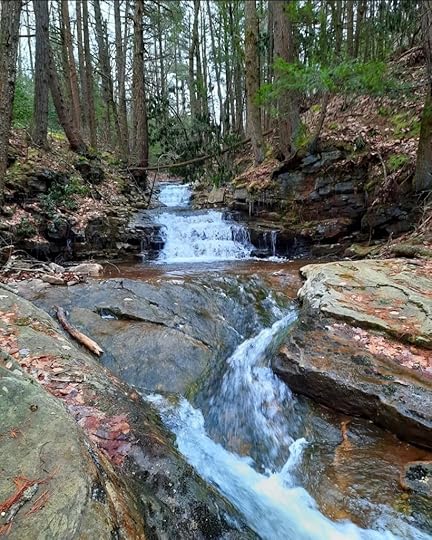 Montage Glen
Length: Approximately 13 miles
Difficulty: Moderate to challenging. Only suitable for more experienced hikers due to navigation.
Parking: 41.347786, -75.678358, off of Montage Mountain Road.
Access: We took the long way in. Balish Road off of PA 307 may offer a more convenient access. Hiking in from the Lake Scranton trail will be much shorter, if it is permitted.
Highlights: Views, hemlock forests, gorges, cascades, waterfalls, stone cabin, Montage Glen, bedrock slides.
Trail conditions: No trails are marked or blazed. This route follows gated forest roads atv trails, and off trail sections. On the map, red is off trail, brown is an atv trail or grade, dashed black lines are atv trails. Expect to cross creeks without bridges.
Description: It is truly remarkable how much beauty surrounds Scranton. Within a few miles of the city are waterfalls, gorges, vistas, lakes, and unique rock features. If trails were built to these amazing places, Scranton would surely become an outdoor recreation destination, rivaling Asheville, Chattanooga, Roanoke or Burlington.
This hike is just an example of that. On the doorstep of Scranton is the relatively vast Montage Tract of the Pinchot State Forest, covering 7,500 acres. Within a few miles of the city is natural beauty and isolation. In the deep gorges and hemlock forests, I could not believe I was on the edge of a city.
From the parking area, walk around the gate and climb up the forest road. Near the top, avoid the road to the right. Reach a gap in the ridge, where the road continues and descends; do not descend. Follow atv trails to the left that climb the ridge. The atv trails ascend to a knob, here you might want to go off trail along the edge of the mountain where there are several nice views.
Continue on the atv trail. Reach a split, it is best to go right as it is less wet. Descend and then gradually climb. Reach the end of a forest road, which I believe to be Montage Road. Follow the road as it descends. Before climbing again on the road, turn left and begin the off trail section. Hike down the valley and make your way through laurel, which is not too thick. A stream forms; this creek does not appear to have an official name, so I called it Stone Cabin Brook for the purpose of description. Continue down the brook as cascades and slides begin to form. We stayed on the west side of the brook. Reach a scenic waterfall with three drops, about 15 feet tall or so. Hike into a beautiful hemlock forest and reach the stone cabin, a quaint, whimsical structure that seems to belong in Snow White. Here, there is an old grade, follow it down along the tumbling stream into more hemlocks. Cross Stone Cabin Brook and hike into a beautiful forest. Reach Stafford Meadow Brook.
It is best to cross Stafford Meadow Brook; there was a fallen log when we were there. Pick up Ore Mine Road and turn right onto it. The brook has rapids, pools and boulders. Cross Stafford Meadow Brook on an old bridge and continue upstream. Begin to climb on the road. Reach a wooden bridge across a creek, a ten foot falls is just downstream. Here, your second off trail section begins.
This is what I called Montage Glen and it is the highlight of the hike, as you will soon see. Make your way up the creek to a twelve foot falls, then a long slide. Above that it another incredible bedrock slide, one of the longest I’ve seen. The beauty is impressive. Above this slide were cascades, falls and more slides, curving through the bedrock. We were stunned.
We continued upstream through moderately thick laurel, hemlocks and pine. There were a few more cascades. We then intersected an atv trail and turned right, heading west. We climbed to a rock ledge and followed the atv trail south to the forest road. We turned right onto the forest road and retraced our steps.
The highlights of this hike are the lower section of Stone Cabin Brook, Stafford Meadow Brook, and the incredible Montage Glen. Be sure to see the glen when there is sufficient water, as it is likely a trickle in dry periods. When hiking this area, keep in mind there are many intersecting atv trails, so gps navigation is a good idea.
Enjoy this beautiful place right next to Scranton.
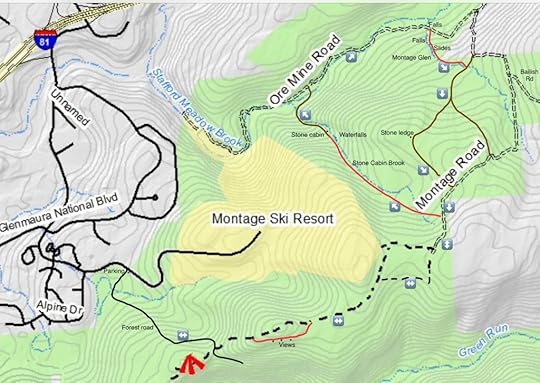 Map is for general directional purposes only, it is not a gps route.
More photos and videos:
View this post on InstagramA post shared by Jeff Mitchell-Outdoors Author (@hiking_mitch)
View this post on InstagramA post shared by Jeff Mitchell-Outdoors Author (@hiking_mitch)
View this post on InstagramA post shared by Jeff Mitchell-Outdoors Author (@hiking_mitch)
View this post on InstagramA post shared by Jeff Mitchell-Outdoors Author (@hiking_mitch)
January 3, 2023
Hike the West Branch Forest Preserve-The Nature Conservancy
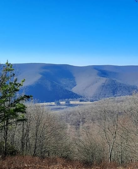
Length: Approx. 14 miles
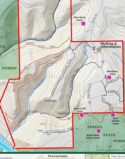
Blazes: Donut Hole Trail is orange, other trails are not blazed.
Highlights: Views, gorges, cascades.
Parking: 41.323858, -77.575713. The road to the parking area can be a little rough and impassable if there is snow or ice. A vehicle with some clearance is a good idea.
Issues: Many trails are not blazed and trail junctures often do not have signs.
Level of challenge: Overall this is a moderate to difficult hike.
Description: The West Branch Forest preserve is a large property owned by the Nature Conservancy, located east of Hyner View. There are deep gorges, cascading streams, views, and isolation. It is a great destination for the more experienced hiker. There are several trails, with the most notable being the Donut Hole Trail; this 100 mile trail passes through the preserve.
From the kiosk, follow an unblazed trail along an old forest road. Ascend gradually and reach the top. Notice an unblazed old forest road to the left, it is the Middle Mountain Overlook Trail. This spur trail follows the ridge with some meadows, crosses a dense grassy meadow, and reaches some partial views. Overall, it may not be worth it.
Reach the orange DHT and turn left. Follow a narrow ridge along a pipeline swath. When the trees are bare, there are views off of both sides. Reach a fine view at the end of the ridge. Descend and follow a very long switchback along an old forest grade. Descend more steeply to Richie Run and then hike above it. Cross Bear Pen Run and hike more closely to scenic Richie Run. Enjoy the hemlocks and cascades. It can be easy to miss where the DHT crosses Richie Run. It is a good idea to follow the unblazed Richie Run Trail upstream several hundred feet to see more cascades and small waterfalls. A trail is barely perceptible.
The DHT makes a long climb out of the gorge along sidehill that clings to the steep slopes. When the trees are bare, it is striking how narrow the gorge is. Pass a cabin and follow a mossy road to the top. Turn right on Sugar Camp Road, and another left on an old forest road to South Overlook Trail. This hike is worth it as the view is beautiful, and perfect for sunsets as it overlooks the ridges and gorges to the west.
Return to Sugar Camp Road and follow it back to the parking area. The West Branch Forest Preserve is an off the radar destination, but perfect for those looking for a challenging, scenic, and isolated hike.
More photos:
View this post on InstagramA post shared by Jeff Mitchell-Outdoors Author (@hiking_mitch)
View this post on InstagramA post shared by Jeff Mitchell-Outdoors Author (@hiking_mitch)
View this post on InstagramA post shared by Jeff Mitchell-Outdoors Author (@hiking_mitch)
December 22, 2022
Hike to Wanamie Falls-Pinchot State Forest
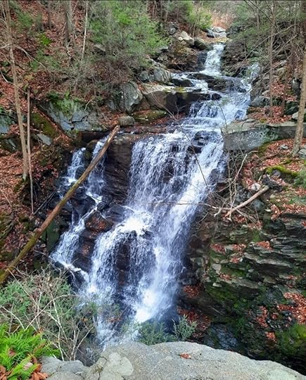 Wanamie Falls from the rock outcrop.
Length: About .6 mile, one way.
Trail conditions: Good. No trail to the base of the falls.
Blazes: None
Highlights: Meadows, wildflowers, waterfall, rock outcrop
Issues: No trail to the bottom of the falls, need to scramble down
Parking: A lot is located at 41.175630, -76.026584.
Level of challenge: Easy, except if you try to go to the bottom of the falls.
Description: This is a very short hike to a surprisingly beautiful waterfall. Despite this region being extensively mined in the past, it still holds places of great beauty. This hike is on the Penobscot Ridge Mountain Bike Trail, which really follows jeep or atv trails. This hike is on the Wanamie Tract of the Pinchot State Forest.
From the parking area, simply follow the trail up through meadows that must be beautiful in summer. Cross over Reservoir Creek and continue a gradual climb. Meadows are off the the left, while a gorge with trees is on the right. Enter the woods and the trail crosses the creek on a footbridge above the falls. You can hike to an impressive buttress of rock on the west bank to see the falls from above.
To get to the bottom of the falls, it is best to descend on the east side as it is less steep than the west. There is no trail. Wanamie Falls has three drops, all total it is about forty feet tall. The buttress of rock enhances the scenery. Retrace your steps.
I hiked a little more of the Penobscot Ridge Mountain Bike Trail but it seemed to be primarily a rutted atv trail, so I turned around.
To see a beautiful falls with a short hike, it doesn’t get much better than Wanamie Falls.
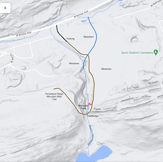 Red is off trail route to the bottom of the falls.
More photos:
View this post on InstagramA post shared by Jeff Mitchell-Outdoors Author (@hiking_mitch)
Jeff Mitchell's Blog
- Jeff Mitchell's profile
- 3 followers


