Hike to Montage Glen and Gorges-Pinchot State Forest
 Montage Glen
Length: Approximately 13 miles
Difficulty: Moderate to challenging. Only suitable for more experienced hikers due to navigation.
Parking: 41.347786, -75.678358, off of Montage Mountain Road.
Access: We took the long way in. Balish Road off of PA 307 may offer a more convenient access. Hiking in from the Lake Scranton trail will be much shorter, if it is permitted.
Highlights: Views, hemlock forests, gorges, cascades, waterfalls, stone cabin, Montage Glen, bedrock slides.
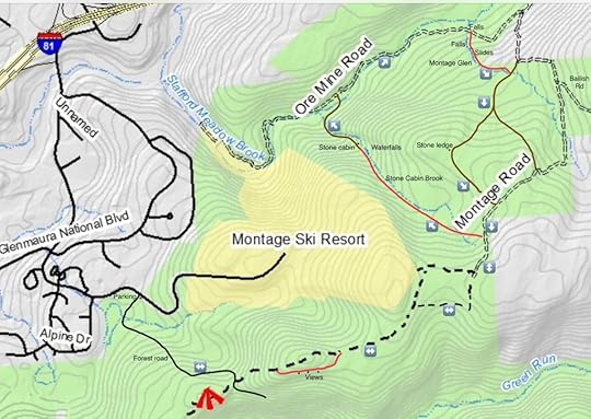
Trail conditions: No trails are marked or blazed. This route follows gated forest roads atv trails, and off trail sections. On the map, red is off trail, brown is an atv trail or grade, dashed black lines are atv trails. Expect to cross creeks without bridges.
Description: It is truly remarkable how much beauty surrounds Scranton. Within a few miles of the city are waterfalls, gorges, vistas, lakes, and unique rock features. If trails were built to these amazing places, Scranton would surely become an outdoor recreation destination, rivaling Asheville, Chattanooga, Roanoke or Burlington.
This hike is just an example of that. On the doorstep of Scranton is the relatively vast Montage Tract of the Pinchot State Forest, covering 7,500 acres. Within a few miles of the city is natural beauty and isolation. In the deep gorges and hemlock forests, I could not believe I was on the edge of a city.
From the parking area, walk around the gate and climb up the forest road. Near the top, avoid the road to the right. Reach a gap in the ridge, where the road continues and descends; do not descend. Follow atv trails to the left that climb the ridge. The atv trails ascend to a knob, here you might want to go off trail along the edge of the mountain where there are several nice views.
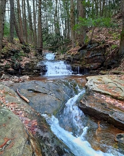
Continue on the atv trail. Reach a split, it is best to go right as it is less wet. Descend and then gradually climb. Reach the end of a forest road, which I believe to be Montage Road. Follow the road as it descends. Before climbing again on the road, turn left and begin the off trail section. Hike down the valley and make your way through laurel, which is not too thick. A stream forms; this creek does not appear to have an official name, so I called it Stone Cabin Brook for the purpose of description. Continue down the brook as cascades and slides begin to form. We stayed on the west side of the brook. Reach a scenic waterfall with three drops, about 15 feet tall or so. Hike into a beautiful hemlock forest and reach the stone cabin, a quaint, whimsical structure that seems to belong in Snow White. Here, there is an old grade, follow it down along the tumbling stream into more hemlocks. Cross Stone Cabin Brook and hike into a beautiful forest. Reach Stafford Meadow Brook.
It is best to cross Stafford Meadow Brook; there was a fallen log when we were there. Pick up Ore Mine Road and turn right onto it. The brook has rapids, pools and boulders. Cross Stafford Meadow Brook on an old bridge and continue upstream. Begin to climb on the road. Reach a wooden bridge across a creek, a ten foot falls is just downstream. Here, your second off trail section begins.
This is what I called Montage Glen and it is the highlight of the hike, as you will soon see. Make your way up the creek to a twelve foot falls, then a long slide. Above that it another incredible bedrock slide, one of the longest I’ve seen. The beauty is impressive. Above this slide were cascades, falls and more slides, curving through the bedrock. We were stunned.
We continued upstream through moderately thick laurel, hemlocks and pine. There were a few more cascades. We then intersected an atv trail and turned right, heading west. We climbed to a rock ledge and followed the atv trail south to the forest road. We turned right onto the forest road and retraced our steps.
The highlights of this hike are the lower section of Stone Cabin Brook, Stafford Meadow Brook, and the incredible Montage Glen. Be sure to see the glen when there is sufficient water, as it is likely a trickle in dry periods. When hiking this area, keep in mind there are many intersecting atv trails, so gps navigation is a good idea.
Enjoy this beautiful place right next to Scranton.
 Map is for general directional purposes only, it is not a gps route.
More photos and videos:
View this post on InstagramA post shared by Jeff Mitchell-Outdoors Author (@hiking_mitch)
View this post on InstagramA post shared by Jeff Mitchell-Outdoors Author (@hiking_mitch)
View this post on InstagramA post shared by Jeff Mitchell-Outdoors Author (@hiking_mitch)
View this post on InstagramA post shared by Jeff Mitchell-Outdoors Author (@hiking_mitch)
Jeff Mitchell's Blog
- Jeff Mitchell's profile
- 3 followers


