Jeff Mitchell's Blog, page 3
January 31, 2025
Explore the Escarpments of Ricketts Glen State Park
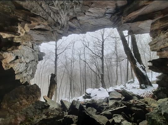 Jigsaw Cave
Length: Various on where you park and hike. You can expect to hike up to about ten miles.
Difficulty: This is a difficult hike with rocky, rugged terrain, cliffs and ledges. All hiking along the escarpments is off trail. Expect brush and steep terrain.
Parking: Beach Lot No. 2 at Ricketts Glen. You can also begin from Mountain Springs Road but I did not come in that way.
Highlights: cliffs, ledges, boulders, ice flows, seasonal falls, cave, overhangs.
Description: Pennsylvania is a state of hidden beauty. This place is an example of that. We all know Ricketts Glen for its magnificent waterfalls, but it is so much more, with cliffs, overhangs, and caves.
I began this hike from the Beach Lot No. 2 parking area because I wanted to see ice flows. You can also begin from Mountain Springs Road for a shorter hike, but that road is not maintained in winter.
The Cherry Run Escarpment is on the west side of Cherry Run. It has no views, but does have a very scenic hemlock forest on top. Cliffs rise to about 50 feet or more, with shorter ledges. There is a seasonal falls on its southern end and what I call the Tangerine Wall, a series of ice flows, over a hundred feet long, with a citrus color. You will also see one huge overhang. Jumbled boulders with moss and ferns are common along the base.
The Bowmans Creek Escarpment is incredible, particularly the southern half. There might be a view on top, but the laurel was so thick, we didn’t find one. This escarpment is just off the unofficial Hall of Hemlocks Trail. You must go off trail to the base of the escarpment. From the north, there are giant cliffs and ledges, with a base of jumbled rock. Reach a massive overhang. As you continue south, the scenery picks up. Reach a seasonal falls, Sometimes Falls, maybe 20 feet tall. Around the corner is the Cove, a special place with ledges and ice flows in winter. Here, is one of the entrances of Jigsaw Cave, which goes through the cliff. Work around a protruding cliff to the impressive entrance of Jigsaw Cave; it is remarkable. Huge cliffs and overhangs continue, until the cliffs and ledges reduce in size with more laurel and hemlock.
Enjoy this beautiful, rugged place.
Ricketts Glen has a lot more cool rocks and cliffs.
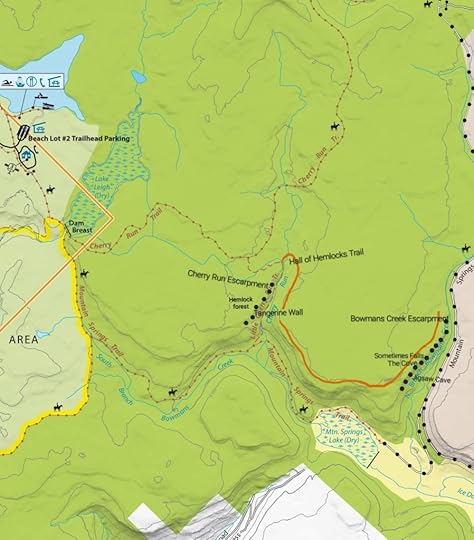 This sketch map is for general directional purposes only, locations are approximate.
View this post on InstagramA post shared by Jeff Mitchell-Outdoors Author (@hiking_mitch)
View this post on InstagramA post shared by Jeff Mitchell-Outdoors Author (@hiking_mitch)
View this post on InstagramA post shared by Jeff Mitchell-Outdoors Author (@hiking_mitch)
View this post on InstagramA post shared by Jeff Mitchell-Outdoors Author (@hiking_mitch)
View this post on InstagramA post shared by Jeff Mitchell-Outdoors Author (@hiking_mitch)
View this post on InstagramA post shared by Jeff Mitchell-Outdoors Author (@hiking_mitch)
January 27, 2025
Pennsylvania’s Best Frozen Waterfalls and Ice Caves
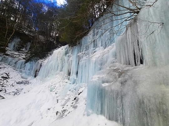 Bradford Falls
Winter is a beautiful time in Pennsylvania and there is nothing like the magic of waterfalls freezing into ice walls, draperies, and caves. Here’s a list of some of the best the state has to offer.
The criteria is not simply a frozen falls, but those that feature large ice walls, draperies, columns or caves.
Obviously, you should always have crampons and even a carbide tipped trekking pole to help you explore the ice. Having an ice axe is a good idea. Another concern is falling ice, so stay away from the ice if it looks unstable, it is warm, or melting.
Eastern Pennsylvania
Factory, Fulmer, and Deer Leap Falls. These three falls are in the George W. Childs Recreation Site in the Delaware Water Gap National Recreation Area. The various angles of the falls make them beautiful when frozen.
Savantine and Sawkill Falls. Located in the Delaware State Forest, these two falls are beautiful. Sawkill Falls is broad with many different leaps, making it ideal for ice formations.
Stairway Falls. A hidden gem. Usually, this falls is not that impressive, trickling over ledges, but in winter it transforms into a stunning ice wall. Don’t miss nearby Stairway Lake and view. Delaware State Forest.
Prompton State Park. Hike the Hiker Trail to a series of ledges that form ice walls and draperies.
Glen Onoko. An incredible place for ice, with towering columns and ice caves. However, it has been closed by the PA Game Commission. The top falls, Cave Falls, may still be accessible, but I’m not sure. If it officially reopens, be sure to visit.
Aqueduct Falls. A must see in winter when it freezes into a towering wall with columns and even an ice cave. Above the falls is the old aqueduct. Pinchot State Forest near Nanticoke.
Ricketts Glen State Park. An epic place for ice, but special regulations apply. The trail is closed in winter except if you have the necessary gear-an ice axe, crampons (not micro spikes), and a rope. Of course, you should also know how to use this gear and go with someone else. In the right conditions, the experience will be unforgettable.
Sullivan and Pigeon Run Falls. Sullivan Falls is near a road, but it may not be maintained well in winter. Its grotto has several ice flows. Upstream is Pigeon Run Falls, which forms a huge ice drapery and even a small cave. State Game Lands 13.
Big, Twin, and Lewis Falls. Wow! Big and Lewis Falls are amazing when frozen, but it is steep to get down to both, so be careful. There are huge ice walls, icicles, and columns. State Game Lands 13.
Salvatore Falls. A short walk leads to this falls, which forms ice draperies and even a cave.
Central Pennsylvania
Bradford Falls. This 70ish foot falls forms massive ice walls. There are three more falls upstream, the top falls, Laquin Falls, can form an ice cave. State Game Lands 36.
Worlds End State Park. Lots of beautiful ice features can be found in this park. High Rock forms a gigantic ice wall. Cottonwood Falls is short, but has a deep pool and an overhanging ledge on the side with ice. Cold Run Trail passes many cascades and falls with ice.
Jacoby Falls. A gem in winter, this is a must see. The falls forms a huge ice wall and a cave. A seasonal side creek also forms an ice cave. Loyalsock State Forest.
Dutchmans Run. This run has several falls and the bottom one features impressive ice. The next falls up also has great ice formations, and a small side stream with extensive ice flows. Loyalsock State Forest near Ralston.
Owassee Slide Falls. Huge ice column and wall in a hemlock glen. The road down to it may not be drivable in winter. Pine Creek Gorge, Tioga State Forest.
Campell Run. A stunning gorge of waterfalls. The bottom has a beautiful grotto and potential for an ice cave. Upstream is Amphitheater Falls which may be difficult to get to in winter. The road down to the falls may not be drivable in winter. Pine Creek Gorge, Tioga State Forest.
Western Pennsylvania
Hector Falls. This falls is so unique, flowing between and over the right angle of a huge boulder. As a result, it can form beautiful ice features. Allegheny National Forest.
Quakertown Falls, Big Run Falls, and Buttermilk Falls (Beaver County). These falls are in various locations, and I’ve not been to them, but they look to potentially form ice caves if you are allowed to walk behind them.
Buttermilk Falls (Indiana County). This impressive falls has a walkway that goes behind the curtain of water, potentially forming an ice cave (if it is open in winter).
McConnells Mill State Park. This park is home to a beautiful gorge formed by glacial meltwater. It also has several falls. Check out Alpha and Kildoo Falls. Alpha forms an ice wall, while Kildoo can form an ice cave.
Cucumber Falls. Located in glorious Ohiopyle State Park, Cucumber Falls is a must see. In winter, it can form a striking ice cave. Ohiopyle is so beautiful, with many other waterfalls to experience.
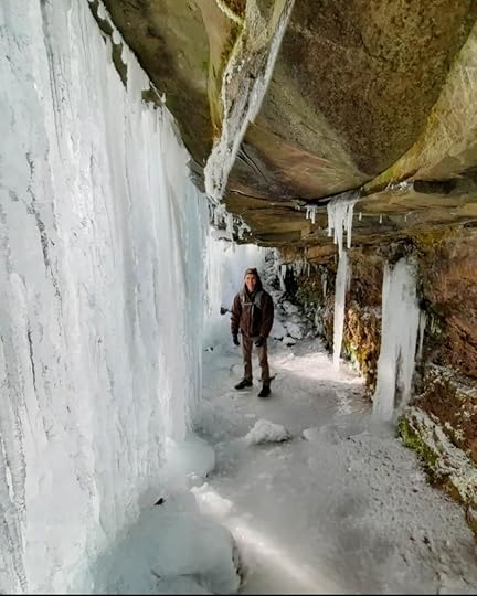 Ice cave at Jacoby Falls
January 13, 2025
Hike to Helayna Falls and the Big Slide-Loyalsock State Forest
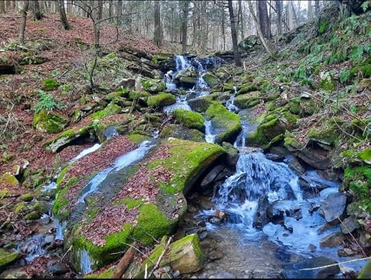 Helayna Falls
Length: About 2 miles, one way.
Parking: 41.439585, -76.625267 Parking area is small, do not block gate.
Difficulty: Moderate. It is rocky on the off-trail hike down to Helayna Falls.
Trail conditions: Trails are well blazed and established, but there are two off-trail sections along creeks. Areas are muddy and you will need to cross creeks without bridges.
Highlights: Waterfalls and cascades.
Issues: Hike when there is enough water to see the falls, but avoid in high water. There is a stream crossing on Ketchum Run that does not have a bridge.
Description: This enjoyable hike visits cascades and falls most hikers overlook. From the parking area, follow the Ketchum Run Trail under hemlocks and along a creek. After about a quarter mile, look for the Fern Rock Nature Trail, blazed yellow with a blue fern, turn left on it. Hike along Ketchum Run with a falls and cascades, it is scenic. The nature trail moves away from the creek. Here, go off trail and follow Ketchum Run downstream where you will see the Big Slide and other cascades. The slide is impressive. Reach the red bridle trail and turn left, crossing Ketchum Run. Veer right onto the Ketchum Run Trail, which is along an old grade. Pass a log cut like a toilet seat. Reach the Loyalsock Trail (LT) and veer left.
You will soon reach Point A. Follow an old red/orange blazed trail to the right of the LT. Hike down to an unnamed creek. Now turn right and go off trail, hiking down the creek. This creek is seasonal so make sure you hike when it is flowing. As you descend, the gorge narrows with boulders and cascades. Reach Helayna Falls in a beautiful hemlock grotto. The top two drops are less than 15 feet tall, but the following series of cascades make the falls over 40 feet tall. There are large mossy boulders. You can see Ketchum Run down in the valley. After enjoying this scenic, serene spot, retrace your steps.
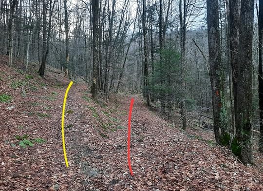 Point A. LT is yellow. Veer right on an old red/orange blazed trail down to an unnamed creek.
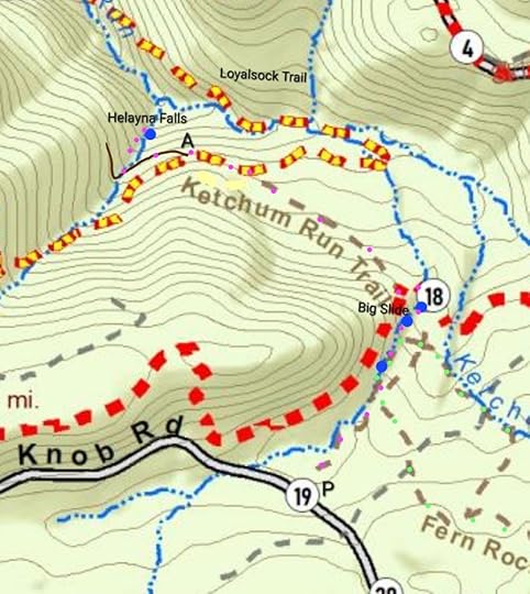 Dark brown is old trail blazed red/orange. Big Slide and Helayna Falls are off trail. Purple dots are my route, but trail is not marked that way.
View this post on InstagramA post shared by Jeff Mitchell-Outdoors Author (@hiking_mitch)
View this post on InstagramA post shared by Jeff Mitchell-Outdoors Author (@hiking_mitch)
January 7, 2025
Hike to the Caves of the Porcupines and Plateau Grotto-SGL 57
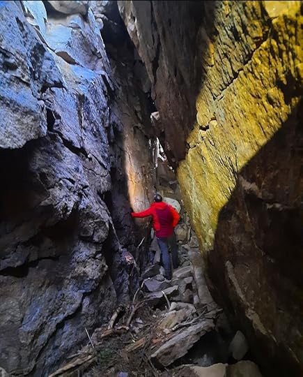 The Caves of the Porcupines
Length: Various depending on where you start, from Windy Valley Road (Kasson Brook on map) you can expect to hike over 13 miles if you go all the way to Atkinson Falls. The hike is shorter if you start from the parking area at 57-35C on the map.
Difficulty: Moderate, but rocky and rugged near the caves, grottos and rock formations, and down to Atkinson Falls. Watch your step exploring the tops of these formations, it is best to explore from the bottom.
Parking: 41.473831, -76.142578 at Windy Valley Rd, or Kasson Brook on map. This is year-round access, although the parking area is not plowed. 41.418136, -76.163697 is a closer access (57-35C on map) but is at the end of a gated road, only open during hunting season. This road is inaccessible if there is snow or ice, and a vehicle with clearance is recommended.
Highlights: Waterfalls, cascades, large rocks, rock formations, caves.
Trail conditions: Henry Lott Road is gated, easy to follow, and gradual. There are no marked trails. Other than the road, all hiking is off trail.
Description: Pennsylvania is such a beautiful state with so many hidden wonders and SGL 57 is one of its crown jewels. I’ve walked by these places a half dozen times before finding them. This hike features superb rock formations and features, waterfalls, cascades, and isolation. If you love rock features, you’ll want to explore this place. I do not describe a specific route, that is up to you, but I will go over the features.
Atkinson Falls and the Countless Cascades is an impressive spot when there is strong flow. The cascades are truly worthwhile under those conditions, with nonstop cascades bouncing from the large rocks. The falls are in a glen with large boulders, and features a side falls in high water. Somer Brook Falls was not included on this hike, but is definitely worthwhile, being one of the tallest falls in the Endless Mountains.
The highlights are the Plateau Grotto and the Caves of the Porcupines. The grotto is a boulder city with cliffs and many chasms, small caves, and passageways. It is such a great place to explore with moss, ferns, and trees growing out of the rocks.
A few hundred feet to the north are the Caves of the Porcupines, which will require you to look around a little bit to find them. There are two caves, one is about 50 feet long and 15 feet tall, the other is about 80 feet long and 40 feet tall. They are not limestone caves, but tectonic caves, formed by the separation of the bedrock. The two caves are very close to each other. A dark hole is an entrance to the 50ish foot cave, so watch your step, you will hike on top of it to get to the 80ish foot cave. The caves are visited by porcupines, hence the name. You will want to look for the caves from the bottom of the rock outcrops and ledges, not the top. Be careful exploring this area.
Arch Rock and cave are a cool spot. The rock is a stack or pedestal of boulders, forming an arch with a cliff. Nearby is a slot cave, maybe 30 feet deep.
Enjoy this beautiful area, one of many in SGL 57.
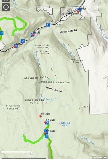 Black dots are cliffs, ledges, caves, rock formations. Blue are waterfalls, light blue cascades. Pink is section to hike on Henry Lott Rd, but is not blazed that way. Locations are approximate, you will need to look around to find them. Terrain is rocky and rugged.
View this post on InstagramA post shared by Jeff Mitchell-Outdoors Author (@hiking_mitch)
View this post on InstagramA post shared by Jeff Mitchell-Outdoors Author (@hiking_mitch)
View this post on InstagramA post shared by Jeff Mitchell-Outdoors Author (@hiking_mitch)
View this post on InstagramA post shared by Jeff Mitchell-Outdoors Author (@hiking_mitch)
View this post on InstagramA post shared by Jeff Mitchell-Outdoors Author (@hiking_mitch)
View this post on InstagramA post shared by Jeff Mitchell-Outdoors Author (@hiking_mitch)
View this post on InstagramA post shared by Jeff Mitchell-Outdoors Author (@hiking_mitch)
View this post on InstagramA post shared by Jeff Mitchell-Outdoors Author (@hiking_mitch)
View this post on InstagramA post shared by Jeff Mitchell-Outdoors Author (@hiking_mitch)
January 4, 2025
Hike the Pole Bridge, Shanerburg Run, and Rusty Run Falls Loop-Loyalsock State Forest
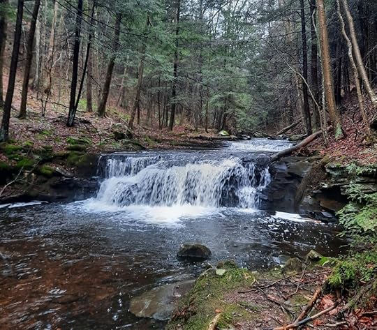 Top drop of Rusty Run Falls
Length: Approx. 9 miles
Difficulty: Moderate
Parking: Small lot at 41.452459, -76.530315 or 41.452789, -76.530178
Trail conditions: Mostly good, some sections are unblazed but obvious. Pole Bridge Trail is “followable”. Expect blowdowns. This loop has several turns, but no off trail hiking.
Blazes: Red, or unblazed.
Issues: Several stream crossings without bridges, particularly along Shanerburg Run.
Highlights: scenic streams, waterfalls, hemlock and spruce forests, meadow, cascades, isolation.
Direction of description: I recommend you go clockwise because Point B is easy to miss going counterclockwise.
Description: This isolated loop is ideal for those looking to explore somewhere different, it combines a variety of trails to make an enjoyable loop. From the parking area, hike up Route 154 to a cabin on the right. Don’t go up the driveway, rather punch through the hemlocks to the left of the driveway (Point A) and follow a grade. This is the old Pole Bridge Trail, which is blazed red. While officially abandoned, it still exists and is fairly well blazed. Follow the grade high above the creek. Enter hemlock forests with some large trees. There are blowdowns along the trail. The creek comes closer, but you need to hike off trail to see it. There are many cascades and rapids, but no large falls. Regardless, Pole Bridge Run is beautiful with a primeval, isolated feel.
Cross the creek and climb a grade with more hemlocks. At the top of the climb, there are no blazes, but the grade is obvious. Reach Point B, at the bridle trail and turn left, onto a forest road. The road goes through a logged area but returns to the forest and winds down the mountain under hemlocks. At the bottom, make a sharp left along Shanerburg Run.
This next section is gorgeous with deep hemlocks, moss, and spruce. The creek is often close and there are several creek crossings. In one area, the trail may have been rerouted around a floodplain area, look for blazes or follow the blacked-out ones. Reach a scenic meadow with old apple trees. It was not wet on my hike. Reach the juncture of Rusty and Shanerburg Run, a stunning spot with cascades and a pool. I suggest following the unofficial, obvious trail to the right along Rusty Run. It is a scenic shortcut. Return to the red bridle trail and turn right on the road. Cross the creek. At the next bend, an unblazed trail to the left goes to beautiful Rusty Run. Upper Rusty Run Falls is just upstream.
Back on the bridle trail, follow it to Shanerburg Road and turn left. Follow the road to Campsite 693 and turn right. Follow the obvious, unblazed grade behind the campsite and reach the bridle trail at a sign. Turn right and descend into hemlocks. Wind through a glen and enter a hemlock tunnel. Descend to a more open forest with hemlocks and reach a sharp right turn. In the glen off to the left is a 12 foot falls, Bridle Falls. It is worth seeing. Descend to Shanerburg Run, hike along it, cross it, and turn left on the road back to your car.
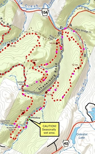 Brown are unblazed trails, blue dots are falls or cascades. Purple dots are my route, but trail is not blazed that color. P is parking.
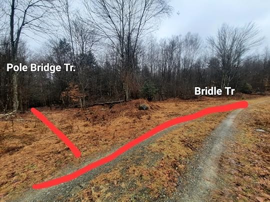 Point B. Best to hike clockwise as turn is easy to miss counterclockwise.
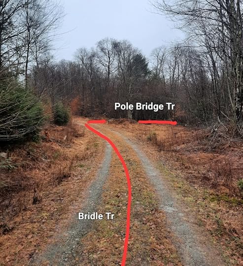 Point B if hiking counterclockwise.
View this post on InstagramA post shared by Jeff Mitchell-Outdoors Author (@hiking_mitch)
View this post on InstagramA post shared by Jeff Mitchell-Outdoors Author (@hiking_mitch)
View this post on InstagramA post shared by Jeff Mitchell-Outdoors Author (@hiking_mitch)
December 5, 2024
Should You Get a Frameless Pack? Things to Consider for Backpacking and Long-Distance Hiking
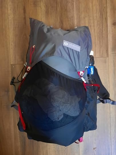 My Gossamer Gear Kumo 36
Until a few years ago, frameless packs seemed to be something only fringe ultra lighters used. Now, frameless packs are becoming increasingly mainstream. The reason why is clear- gear has become lighter and more compact, making a frame unnecessary in some circumstances. Going into the future, the trend of lighter and more compact gear will continue.
Like many backpackers, I only used framed packs for years. In my mind, I couldn’t imagine not having the load carrying benefits of a hip belt. I then decided to give a frameless pack a try, and now I’m a believer.
As for my hiking experience, I’ve completed the Appalachian, Colorado, Long, and Northville Placid Trails, and many shorter trails. I only used a framed pack on those longer hikes, but have used frameless on shorter ones.
Here are some reasons why you might want to transition to a frameless pack:
Well, they’re lighter! A frameless can be around a pound lighter than the lightest framed pack. It’s not just the lack of a frame, but the stitching, fabric, and materials needed to hold the frame.They’re cheaper! No frame, less materials, cheaper price.Frames bend, break, squeak, and can wear into your pack. With a frameless, you never have to worry about those things. By being so simple, frameless packs are often more durable.Don’t need a hip belt! A big reason for me, I love hiking without a hip belt. I just feel I move more naturally. Hip belts can also lead to more sweating, chaffing, redness, or abrasions.Perfect for hot weather hiking. Similar to reason No. 4, frameless packs are much cooler without a hip belt wrapped around you. Yes, frameless packs are known for a lack of back ventilation. One thing that has helped me (if your pack has a mesh sleeve or cords) is using a firm, egg crate foam pad against my back. This has helped with ventilation and also works as a sit pad. Versatile! Many frameless packs have simple hip belts that move better with your body than the traditional thicker ones. This is ideal for people who like hip belts, or want a belt to help carry some of the weight. In most frameless packs, these belts are removable. Frameless packs can also be used as a daypack.Can be perfect for weekend trips. Not everyone does long distance hiking, the vast majority of backpackers do weekend trips. Frameless packs can be perfect for those trips when you don’t need to carry as much food. On a related note, frameless packs are also ideal for summer weekend backpack trips. You use a fold out foam sleeping pad. If you cut the length of the pad, it can be folded up and put in a frameless pack, giving it a “frame” and helping direct weight to your hips if you also use a hip belt.A smaller pack makes you streamline your kit and requires you to be more disciplined about what you’re carrying.Reasons not to transition to a frameless pack:
There’s no question, framed packs can handle more weight comfortably. If you like your comfort items or don’t have light gear, no problem, but a frameless may not be for you. Base weights for frameless packs should be around ten to twelve pounds, and frameless packs often become uncomfortable when total weight goes into the low to mid twenties. If you’re on a hike with big water and food carries, again, a frameless pack may not be the best choice.What I look for in a frameless pack:
Wider, curved shoulder straps. In a frameless pack, shoulder straps take on even more importance. Running vest style straps are ideal, or any that are wide to distribute weight more comfortably.Back mesh or straps to hold a foam pad. Not all packs have this, but I like them. It gives the pack structure, helps prevent gear from poking your back, and can help with ventilation (see above).Removable hip belts.Mesh pockets on shoulder straps. Specifically, pockets that can hold about a 600 ml bottle. I like to hold my water bottles there, it feels lighter close to my torso as compared to side pockets near my lower back. It also counteracts the weight of my pack. Water is quite heavy and shoulder strap pockets ease that burden. Big rear mesh pocket. This goes for any pack, something to stash gear I need through the day or to dry clothing.Side pockets that can hold two liters of water. This seems to be the standard, big side pockets can also hold other gear as well. If I didn’t have shoulder strap pockets, I’d want a pack where I can easily reach my water in the side pockets without taking my pack off or loosening straps. Roll down top. Just a preference. Water resistance. A preference but not a deal breaker as a trash compactor or nylofume bag works just as well.What companies make frameless packs?
Some are Nashville Packs, Pa’lante Packs, Outdoor Vitals, Hyperlite Mountain Gear, Gossamer Gear, Durston Packs, Superior Wilderness Designs, Mountain Laurel Designs, Desolo, Zpacks, Osprey Packs, Mountainsmith, ULA Equipment.Is there a best buy among frameless packs for those looking to give it a try?
Many people say Gossamer Gear’s Kumo 36 is the best buy among frameless packs. It is roughly half the price of many other packs (even cheaper during sales), the pack alone (no hip belt) is just over 14 ounces, it is versatile, and very comfortable. I have one and can attest to its comfort (I paid for it and did not receive any incentive for this plug). Unlike other packs, it is not water resistant, and has Gossamer Gear’s classic fold over top as compared to a roll down top. I also have a Desolo Tallac 35, a good pack. It is inexpensive, water resistant, and has a huge mesh pocket, but the shoulder straps are not as comfy as the Kumo. Another idea is to see if the frame of your traditional pack is removable. Many are. That can give you an idea if frameless is for you without spending more money.November 25, 2024
Hike the Devils Race Course Loop-State Game Lands 211
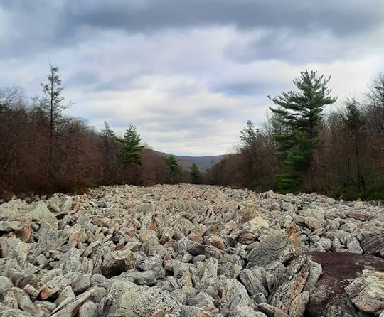 Devils Race Course
Length: About 11 miles
Difficulty: Moderate to challenging. Terrain often rocky. Knauber Trail is steep.
Highlights: Appalachian Trail, Devils Race Course, Stony Mountain Fire tower, isolation.
Parking: Lot at 40.451752, -76.776137
Blazes and trail conditions: Overall, the trails were in good shape and blazed well. Some trail junctures have signs, but not all. The loop was fairly easy to navigate, but you must look out for some trail junctures. The Appalachian Trail (AT) is white, Horseshoe Trail (HST) is yellow, Knauber Trail is red. Other trails are yellow, blue, or red. Two side trails lead to the race course.
Direction of description: Clockwise
Description: This is a great loop featuring the impressive Devils Race Course, possibly the longest boulder field in the east, at nearly a mile long. As you hike this loop, you’ll notice other trails connecting to it, there is an extensive trail network here. This is a remarkably wild and isolated area, considering it is close to Harrisburg.
From the AT parking lot, head north on the trail and cross Clarks Creek. The trail veers left off a forest road and climbs gradually. Pass a juncture with the red Knauber Trail on the right, this will be your return route. Continue on the AT as it gradually climbs the mountain on an old road, passing old collapsed mines. Near the top, notice a yellow trail to the right. I don’t know where it goes, but it might connect to the trails that cross the Devils Race Course, described later.
Reach a juncture with the yellow HST at a monument and turn right onto it. Descend into a valley. Pass a faint red trail to the left. Cross the wooded end of the race course, you can hear water flowing under it. Reach Stagecoach Road or Rattling Run Trail, turn right on it. This is not blazed, but is obvious. Climb and when the road begins to level a little, keep an eye out for a red trail on the right, take it to the race course. Devils Race Course is impressive, it looks like a glacier of rocks. It is long and narrow, with a sizable creek flowing under it. The water is so deep under the rocks, we only saw it once. There are giant boulders. Apparently, the name came from the sound of the water, as if the devil was racing underground. The red trail continues on the other side, I don’t know where it goes. There is also a nice view down the race course.
Be careful hiking the rocks in the race course. While most rocks are stable, some are not. It can also be very slippery when wet.
Return to the road. Continue a little ways and notice a yellow trail to the right, it also leads to the race course. Here it is more narrow with pine trees. A red trail continues on the other side, I don’t know where it goes.
Back on the road, follow it to a red trail on the right, this is the Knauber Trail. Descend into a scenic valley with laurel, pine and hemlock. Pass some old mine pits and then climb along an old road lined with giant rocks. Reach the top of the ridge, the red Knauber Trail goes right, a blue trail is straight or left. You can take the blue trail out to the Stony Mountain fire tower.
Back on the Knauber Trail, descend steeply over rocks. The trail eases and meets the AT. Turn left back to your car.
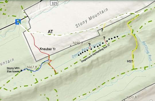 This map is for general directional purposes and is not a GPS route. Locations are approximate, accuracy not guaranteed. Basemap is from the PA Game Commission. The loop follows the AT to HST to Stagecoach Rd, to Knauber Trail, with side hikes to the race course and fire tower. Black dots are Devils Race Course boulder field.
 View this post on InstagramA post shared by Jeff Mitchell-Outdoors Author (@hiking_mitch)
View this post on InstagramA post shared by Jeff Mitchell-Outdoors Author (@hiking_mitch)
November 20, 2024
Hike the Hyner View Loop
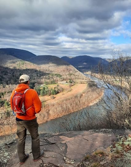
Length: 11 miles
Difficulty: Moderate to challenging
Trail conditions: Pretty good, most trails are blazed well, some trail junctures have signs. Some trails are rougher or less established than others.
Highlights: Hyner View, views, streamside hiking, hemlocks, Johnson Run, small falls and cascades, Huff Run.
Parking: There is a pull off about here: 41.327735, -77.634175
Blazes: Donut Hole Trail (DHT) is orange, other trails are yellow.
Issues: Several stream crossings along Johnson Run, avoid in high water.
Description: This is a wonderful day hiking loop in the PA Wilds. It has views, beautiful streams, and small cascades. The trail winds through gorges and glens. There is a whole trail system around Hyner View, built and maintained by the PA Trail Dogs. Hyner has become a trail running and race destination. This system offers some superb hiking. Try to avoid hiking here on race weekends.
From the parking area, hike the road (I think it is Huff Run Rd) away from PA 120. It dead ends, follow the Cliffhanger Trail. Climb along this fine trail with many views when the trees are bare, and a few narrow views when there are leaves. Reach the DHT and turn right. Follow the edge of the canyon with rock outcrops. Reach a superb view from a cliff looking up the river. Continue on the DHT, which drops into a glen with a small creek, an unmarked trail joins from the left. Climb a ridge, pass Goat Path to the left, stay on the DHT. The DHT follows sidehill above Johnson Run but eventually descends. Cross the creek on a log bridge, leave the DHT and turn left onto Johnson Run Trail.
This is a highlight of the loop as the trail closely follows this scenic mountain stream, there are several crossings. If you love streamside hiking, you’ll love this trail. As you hike, the creek becomes more scenic with hemlocks, moss, and ferns. Climb more steeply to the top of the plateau and turn left onto a yellow trail. Cross the top of the plateau with level and rolling terrain. There is mountain laurel, pine and oak forests. Old View Road is just off to the right. Pass a pipeline swath that resembles a meadow with a view. Reach an old forest road with a gate on the right, turn left. Blazes are few but the route is obvious, this is the Ligenza Trail. Blazes become a little more frequent (the trail is better blazed in the opposite direction) but it is obvious regardless. Reach Hyner View State Park and enjoy the famous vista, it is always more rewarding to hike to it.
Follow the DHT along the road and watch the blazes where the trail veers left off the road. The trail is rugged as it crosses the slope and descends to Huff Run. Turn left onto the Garby/Paulhamus Trail. Huff Run is another highlight, the trail is beautifully built down a narrow, wooded gorge. When the creek is flowing well, there are many cascades and small falls. A true pleasure to hike and a perfect ending to the loop. Cross a bridge and reach the road, turn right back to your car.
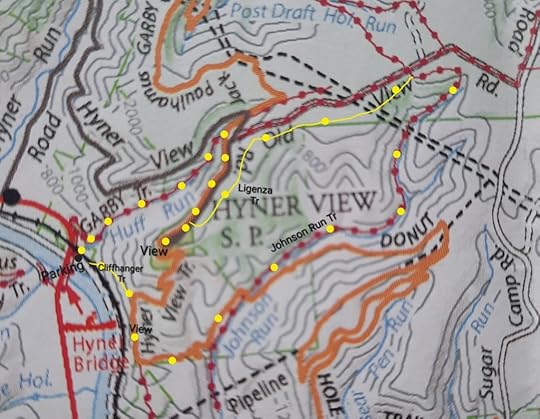 I went counterclockwise from the parking area. Yellow dots were my route. Map from DCNR, locations are approximate.
View this post on InstagramA post shared by Jeff Mitchell-Outdoors Author (@hiking_mitch)
November 14, 2024
Dayhike the Appalachian and South Trails Lollipop Loop
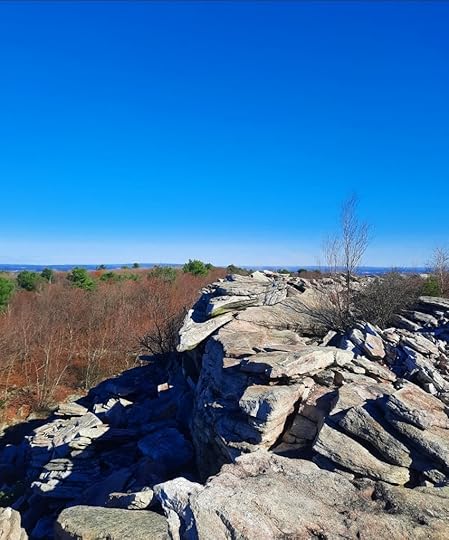 Rugged, beautiful South Trail
Length: Approx. 4 miles
Difficulty: Moderate, but very rocky and rugged in places.
Highlights: extensive views, boulder fields, giant rocks, Appalachian Trail (AT)
Parking: Small lots at about 40.769573, -75.694118 . I drove up Blue Mountain Road, it was in decent shape but a vehicle with some clearance is a good idea. I do not know about Ashfield Road.
Blazes: The AT is white, South Trail is blue
Issues: Rocks on the South Trail can be slippery when wet. South Trail is very rocky over boulders with some scrambling.
Description: This hike features some of the best views in southeastern PA. The South Trail is known for its extensive views, with one section having an almost alpine feel. In places you can see off both sides of the ridge. I believe in the future the AT will be routed along the South Trail. This hike also doesn’t have any big climbs, the terrain is rolling and level. But as noted, it is very rocky.
From the parking pull off, follow the AT north. It is a gradual climb through forests of oak and sassafras. Pass some dry campsites. Rock outcrops begin to appear off to the right. Reach the juncture with the South Trail at a sign, turn right. The trail ascends rock slopes and views begin to appear. Traverse the boulder fields and see some large outcrops, one is like a pedestal, another is a jutting fin of rock. Views are everywhere. Reach the top of the rock slope, my favorite spot, with views off both sides of the ridge, it has an alpine feel to it. There are large ledges and non stop views. We had fun scrambling over the rocks and ledges.
Descend on the South Trail into the woods. The trail is often still rocky. There continue to be views looking south. The South Trail rejoins with the AT, turn left on it. (If you want more views, turn right on the AT and hike for 1.5 or 2 miles for excellent views over the turnpike tunnel and Palmerton).
The AT back to the car is much less rocky than the South Trail, passes along small meadows and pine groves with dry campsites. Pass the first juncture with the South Trail and hike down to your car.
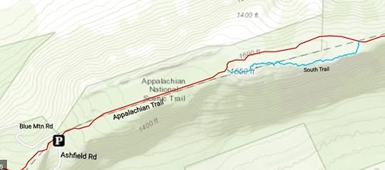 Basemap by the Appalachian Trail Conservancy. I hiked the loop portion counterclockwise. AT is blazed white, South Trail is blue.
View this post on InstagramA post shared by Jeff Mitchell-Outdoors Author (@hiking_mitch)
View this post on InstagramA post shared by Jeff Mitchell-Outdoors Author (@hiking_mitch)
October 28, 2024
Hike to Grays Run Vista-Loyalsock State Forest
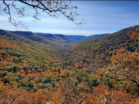 Grays Run Vista, Loyalsock State Forest
Length: Roughly 1.5 miles, one way from Twin Fawn Lodge. Length variable depending on route taken.
Trail conditions: This is an off trail trek, there are no signs or blazes. You should have experience with route finding and off trail hiking. This route follows a creek, an old grade, and a faint trail to the vista.
Difficulty: Challenging with steep, rocky slopes, and mountain laurel bushes. Terrain is rugged, hike is difficult.
Parking: Pull off parking can be found approximately at 41.464514, -77.018050 . You can try to find a place to pull off closer to Twin Fawn Lodge. Past the lodge, the Grays Run Road enters private property.
Highlights: a gorgeous view and cascades when the creek is running.
Another route: I’ve heard it is easier to hike in from the top, from Bodine Mountain Road, but I did not go that way.
Description: This hike leads to one of the finest views in the Loyalsock State Forest. It is an off trail hike. To begin, follow the driveway to Twin Fawn Lodge and cross the creek on a bridge. Give the lodge a wide berth and avoid this hike during prime hunting seasons, like rifle season for deer. The lodge appears to be a leased cabin site on state forest land.
Veer left from the lodge through barberry and enter Turntable Hollow. Hike on the south side of the creek and reach some moderately sized boulders. Above are nice cascades through boulders. Cross the creek and work up the hill. The goal is to find an old grade that angles northeast up the slope. The grades in the hollow are often lined with stones. If you find the grade, follow it to the middle rim of the plateau into laurel. The laurel is moderately thick. At the rim, look for a faint footpath to the left, heading west, along the rim. Follow it.
The laurel recedes and the forest becomes open. Stay along the same approximate elevation. Reach the view, it is located approximately at 41.484412, -77.020635 . The view is impressive, looking down the isolated valley of Grays Run with a series of furrowed ridges. It looks south. The best times for this view are morning when fog might linger in the valley, or sunset when light shines on the furrowed eastern wall of the valley. Return the way you came.
The western edge of the Loyalsock State Forest is often overlooked by hikers but it has some great scenery. While in the area, you might want to explore one of the crown jewels of the Loyalsock, the stunning Frozen Run Gorge.
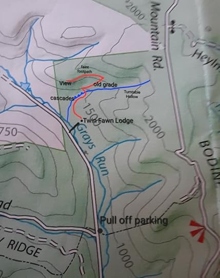 Locations are approximate. This is not a GPS track, map is for general directional purposes only. Red/orange is off trail, blue dots are cascades.
View this post on InstagramA post shared by Jeff Mitchell-Outdoors Author (@hiking_mitch)
View this post on InstagramA post shared by Jeff Mitchell-Outdoors Author (@hiking_mitch)
View this post on InstagramA post shared by Jeff Mitchell-Outdoors Author (@hiking_mitch)
Jeff Mitchell's Blog
- Jeff Mitchell's profile
- 3 followers


