Waterfalls of Rock Run-SGL 13
 Rock Run, SGL 13
Distance: 4-5 miles one way
Parking: 41.396259, -76.429830. The road was in good shape when I drove it.
Access: closer access may be possible from the gated road at the bottom of the map below, or south of Rock Run. It may be open in hunting season, vehicle with clearance is recommended. As Rock Run is the highlight, this would be the best access.
Highlights: several waterfalls and cascades, isolation, wildflowers.
Trail conditions: This hike follows forest roads and is off trail. There are no marked or blazed trails.
Difficulty: Moderate for off trail hiking. Do not cross Muncy Creek in high water. You should have experience in off trail hiking to do this hike.
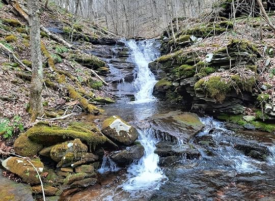
Description: There are many Rock Runs in Pennsylvania, and like those other streams, this one is a beauty. SGL 13 is famous for its collection of waterfalls and these are among its most isolated.
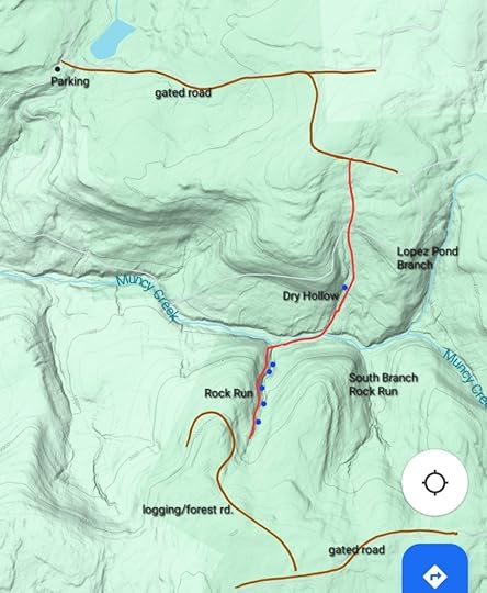
From the parking area, I followed the gated roads to the top of Dry Hollow. From there, I bushwhacked down the hollow. There was no thick brush. As I descended, a creek formed and there was a 15ish foot falls. While it was not spectacular in its own right, it was worth seeing since it was along the way. Dry Hollow entered some hemlocks and joined Muncy Creek.
Muncy Creek’s valley was serene and isolated. Old logging or rail roads once followed the creek, the grades are evident but also eroded. I liked the isolated feel of this valley with its groves of hemlocks. I hiked down Muncy Creek and then turned up Rock Run. Rock Run is a small creek, likely dry in summer, but it is a beauty. You’ll soon see why. There are bedrock cascades and falls, the tallest is about 20 feet. Above the tallest falls is a striking mossy bedrock grotto with slides and boulders, a beautiful spot. The beauty continues with broad ledge falls and cascades. You’ll notice an old grade on the west slope of Rock Run that can be used to explore. As you near the top, a logging or forest road is nearby, just to the west. You can take that to the gated road to the south, the best and most convenient access if it opens in hunting season.
I also hiked Lopez Pond Branch and South Branch Rock Run, both were beautiful but had no waterfalls. South Branch Rock Run in particular looked to have wildflowers.
I did this hike in April. There was little thick brush, but I do not know if nettle would be an issue in summer.
Return the way you came. Enjoy the isolated and beautiful place.
 Blue dots are waterfalls. Red is off trail. Brown are forest or logging roads. Locations are approximate, accuracy is not guaranteed. This is not a gps track. Hike at your own risk.
 View this post on InstagramA post shared by Jeff Mitchell-Outdoors Author (@hiking_mitch)
Jeff Mitchell's Blog
- Jeff Mitchell's profile
- 3 followers


