
Max Carmichael's Blog, page 21
September 6, 2021
Cold Feet
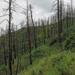
Stressed out almost to the breaking point by the struggle to get my life back, I’d been pushing myself too hard on recent hikes. I’d been having adventures, and people seemed to enjoy reading about them, but few seemed to realize that I actually hadn’t been having much fun. Au contraire, I’d been suffering and ending up miserable in one way or another after every hike.
This Sunday I wanted to break the pattern and do a hike that was easy but beautiful. Unfortunately that turned out to be much easier said than done. As I’ve mentioned in the past, southwest New Mexico is just not my favorite habitat – I’d rather be in the desert.
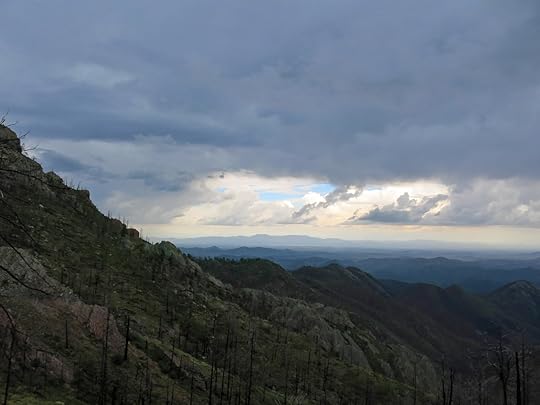
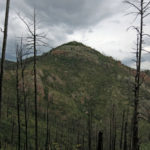
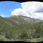
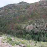
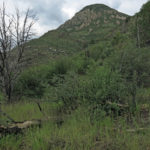
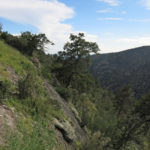
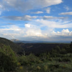
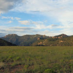
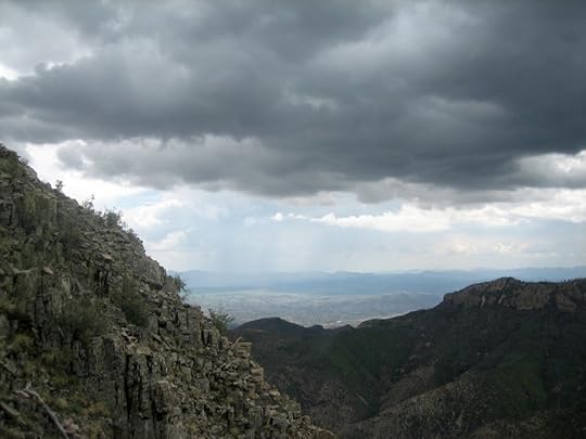
Finally I decided to return to the 10,000′ peak with the fire lookout an hour east of home. It was a fairly easy hike – 11 miles round-trip but only 2,000′ of elevation gain – with long views, and there were those grassy meadows just below the peak surrounded by giant old growth firs. If I could restrain myself from continuing down the other side to get more mileage and elevation, maybe I could just hang out in the grass and relax for a change. Listen to the birds and watch the butterflies.
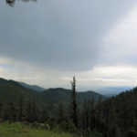
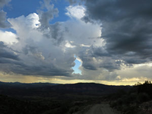
The desire to just hang out in nature is often only wishful thinking. In this case, the grass in the meadows was heavy with dew. So I continued down the back side to the saddle. On the way, I watched a big storm developing and dumping rain a few miles away to the northwest.
By the time I reached the saddle, the storm had spread over me and a few drops were falling. I thought, great, I’ll spread out my poncho as a shelter and hang out here under the big ponderosas. But it turned out my cheap poncho was too small and had no grommets, and anyway, I wasn’t in the habit of carrying cord to anchor it to trees and branches. Without shelter, I couldn’t sit down – I had to keep moving. The only thing I could do was give up on this hike and head back home in the rain.
For the first time this season, I was actually cold. The temperature had dropped into the sixties, and the rain and humidity were sapping my body heat. Ironically, I’d left my emergency sweater at home today, because I’d been too hot on every hike so far this summer. I could see the storm was surrounding the peak now, so I changed into my rain pants and poncho. Hopefully the poncho would act as a thermal barrier and keep me warm.
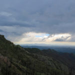
It occurred to me that this was the first time a storm had noticeably reduced the ambient temperature during this year’s monsoon. In past monsoons, afternoon storms had almost instantly lowered the temperature by as much as 30 degrees. That was one of their best impacts. Our climate had definitely changed, in a way that was likely to be catastrophic. Despite all the rain we were getting, the average temperatures this summer felt much, much higher than in the past.
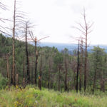
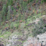
As I started climbing back up toward the peak, the rain was light at first, and I was feeling fine. Then about halfway up, I was suddenly hit by a barrage of hail, and for the next half hour, I climbed through a deluge of mixed rain and hail. The trail turned into a creek and I had to walk above it through dense, soaking wet grass and brush. When I was only a few hundred yards from the peak, lightning struck it, followed by one of the most violent thunderclaps I’ve ever heard. There was no place to shelter so I just kept hiking, looking forward to getting home early since I hadn’t hiked as far as usual.
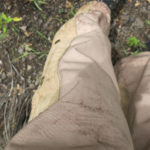
By the time I crossed the peak and started my descent, the hail had stopped and the rain had lightened up, but my feet were soaked inside my boots. A mile down the mountain the rain finally stopped and I changed into dry socks. But within another mile the water in my boots had soaked through the new socks. They were “Smartwool”, but they weren’t working – my feet were freezing.
A mile farther down the mountain, a gale force wind rose out of the west, and a new storm began. The trail turned into a creek again and the normally difficult rocky stretch had been eroded and made harder to walk on. It was wonderful that we were having this wet monsoon, but every hike seemed to be turning into an ordeal. Maybe I should just stop hiking until the monsoon ends – but then I would have to work to rebuild my conditioning.
The worst part of the day turned out to be the drive home. I hadn’t brought a dry pair of shoes and socks, and driving barefoot is not an option with my foot condition, so I had to drive home in cold, wet boots. It felt like my feet were encased in sponges soaked with freezing water. I had the heater on, but it took almost the entire drive to warm them up.
Others have probably noticed that I’m strongly achievement oriented. My peace of mind depends on accomplishing stuff I’m passionate about. But for more than a year, since the house fire, I’ve been unable to work on music, art, or my book project. Managing the repairs on my house is like pulling teeth. These hikes are my only chance to achieve something really satisfying.
People who function as an integral part of their habitats – subsistence cultures who provide for their own needs instead of shopping in the capitalist consumer economy – are always aware that immersing yourself in nature is hard work – dangerous and often unpleasant. I don’t hunt, fish, or farm, but by hiking all year ’round in all kinds of weather I avoid some of the illusions of the civilized, “recreational” lifestyle. And during a wet monsoon like this, hiking for pleasure is seldom even an option.


August 30, 2021
My Favorite Trail?
I was hankering to get back to my favorite trail, the rollercoaster hike that takes me across two rocky canyons and the rolling plateau in between, with spectacular views at almost every point. The weather was forecast to be warm but not hot, with the potential for some afternoon cloud cover, if not a bit of rain.
Descending into the first canyon, the first thing I noticed was the flies. They were everywhere today, not just in the humid canyon bottom. I decided to try ignoring them at first.
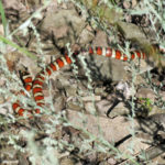
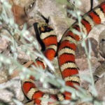
Halfway down I came upon one of the most beautiful snakes I’ve ever seen, lounging right on the trail. I grew up obsessed with snakes, and despite decades of forgetfullness I figured it for a kingsnake or milk snake. Back home I would identify it as an Arizona/Sonoran Mountain Kingsnake – my first.
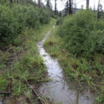
The creek had been dry on my last visit, three weeks into the monsoon. Now it was roaring, and I had to find a stick to stabilize my crossing over flooded steppingstones. One of my boots got wet, but I figured it would dry out soon. The crossing was precarious enough that as I continued the hike I scouted for a pair of sticks to use on my return, and left them along the trail where I could easily spot them later.
There had been two city vehicles at the trailhead – first time I’d seen anyone else there – and only a mile into the trail I saw two men about my age camping on the bank of the creek. Now I knew I had the rest of the trail to myself.
Despite the mild temperature and the steep north slope being in shade, it was humid enough that I was drenched with sweat on the long climb out of the canyon, and the flies gave me no peace. After one had flown up my nose and another down my throat, I finally gave up and pulled on my head net. It was hard wearing it while sweating so much, and I still hoped the flies would fade away at higher elevations, but no such luck – they stayed with me all day.
I was trying to maintain a steady, relentless pace, because I wanted to go farther than before, to the bottom of the third canyon. The only place where it’s possible to go fast is the middle rise of the plateau between first and second canyons. I hadn’t seen any human tracks on the climb up, but suddenly on that middle rise I found a recently trampled annual plant. After that I looked closely for tracks but could only spot animal sign, until I finally neared the far edge of the plateau, climbing out of the last deep hollow toward the saddle above the West Fork. There I found a track that at first looked like a boot print, but which I eventually realized was from a big bear.
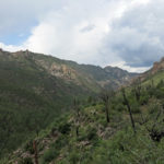
I started down into the deep canyon of the West Fork, with the long, talus-striped wall of Lookout Mountain towering above on the opposite side. It was slower going than before due to additional deadfall, and the steep, rocky trail was as treacherous as ever.
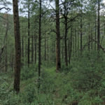
One of the points you most look forward to on this hike is after that brutal descent, entering the parklike ponderosa pine forest at the bottom of the trail, above the west bank of the West Fork. I’d been a little worried about crossing the West Fork, but easily found two sticks and adequate steppingstones. As before, I left the sticks where I could find them on my return.
After all our recent rain, the less-maintained trail beyond the creek turned out to be densely overgrown. Clearly nobody but me was using this trail. Most people only walked the first mile, to the first creek, and no one except me had climbed to the plateau this summer, let alone penetrated all the way to the West Fork.
As I fought my way up the steep traverse across the base of Lookout Mountain, it was starting to dawn on me that despite this being my favorite trail, it was damn hard, and damn slow going. I’d been imagining the extension to the third creek just in terms of miles and elevation, but what with the steep and rocky trail, the humidity, the flies, and the chance of rain, it became an excessively long, slow ordeal.
Eventually I reached the farthest point I’d hiked to in the past – the saddle where the traverse begins descending into the third canyon. I was pretty much spent, but I just had to go a little farther, to make this day’s hike worthwhile.
In the end, I descended far enough to see into the third canyon. There was a storm building over it, and the canyon itself turned out to be rockier and a little prettier than I’d expected. I got to a point where the trail skirted a cliff edge that gave a good view both upstream and down. It was time to turn back, but I was glad I’d achieved that new view.
The rain caught me on the way back, just as I reached the saddle below Lookout Mountain. It came down pretty hard, but huddling under a small juniper, it took me 15 minutes to change into my new rain pants, by which time the rain had ended. Such is our weather. However, I was glad I had those pants on while pushing through the wet vegetation that overgrew the trail.
As I returned toward and across the West Fork, the storm spread north and west over the second canyon. I always want to stop and hang out in the parklike forest on the west bank, but I’d had to make so many stops I was now behind schedule.
It started to rain again just as I was starting to climb that brutal slope out of the canyon. So I switched hats and prepared to don my poncho, only for the rain to stop again. But the flies were relentless.
I was so worn out, and sweating so bad, it seemed to take forever to climb that slope. I was literally stopping about every hundred feet to catch my breath. What an incredible relief to reach the saddle and start back across the plateau!
The storm dispersed as I headed west. I was now moving as fast as I could, and continuing to work up a sweat even when going downhill. The long switchbacks into the first canyon seemed interminable, and I had to keep wiping sweat out of my eyes, through the head net, which drove the flies nuts.
Nearing the first creek, I grabbed the two sticks I’d left in the morning. But after the day’s rain over the head of the canyon, the creek had risen over all the stepping stones. I tried to add more but the creek was just too wide and deep now. I’d simply have to try crossing barefoot – something really dangerous for my foot condition.
Using the sticks to stabilize myself, I stepped across very slowly through the rushing flood waters, across the rocky creek bottom, feeling carefully with each step for footing that wouldn’t put weight on the ball of my left foot. I finally made it across and immediately sat down on the rough rocks of the bank to dry my feet and pull my boots back on. The whole process had taken another 15 minutes – I calculated that over an hour of my hike had been used up in stops like this. It was turning into a 9-1/2 hour hike, almost as long as my “longest hike”, despite only being 14 miles total.
The blister on my little toe had returned, slowing me down even more. The sun was just setting as I reached the vehicle. I wouldn’t get home until 8:30. Fortunately I had a frozen burrito left, to warm up in the microwave…
August 23, 2021
The Longest Day
Insomnia Saturday night…only 3 or 4 hours of sleep. When my alarm went off at 6 am, I had no faith in my ability to get back to sleep, so I got up and prepared for my Sunday hike. I felt half dead, and figured I’d just go as far as I could, and stop for a nap along the trail if I ran out of steam.
I’d already decided to take the trail I’d hiked most frequently and used to consider my favorite. How things have changed in only two years! When I first hiked this trail, the 10 miles to the crest and back was two miles too far. Now, 15 miles doesn’t seem far enough.
Last time I’d been over here, I’d discovered a trail crew had cut a path through the many deadfall and blowdown logs that’d accumulated since the last trail work in 2019. I wondered if they’d continued up on the ridge, where the trail snakes along the crest into the heart of the range, and where I’d been exploring farther and farther over the past year, bushwhacking over deadfall and through thickets of thorny locust. If they’d cleared that part of the trail, I might be able to make it all the way to the junction saddle. That would be pretty cool.
I wore my new “upland hunting” pants, in case of rain. The day started out cool, but the lining in the damn pants ensured that I immediately overheated down in the humid jungle of the canyon bottom. And the flies – gnats, really – swarmed me from the beginning, so I quickly got tired of swatting and donned my head net.
Two and a half miles in, not far from where I’d encountered a rattler on my last visit, I was forcing my way through the jungle when I spotted a rattlesnake tail receding across the trail right in front of me. It disappeared under the dense vegetation on my left, rattling weakly. I started pushing through the equally dense vegetation on my right, but that triggered a second rattle. There were two snakes, one on each side!
I retreated out of the thicket and found a broken limb that made a good walking staff. I returned to the snake spot and began probing ahead through the vegetation on both sides of the trail. No response. I crossed the jungly patch and passed a small tree. More rattling on my left. After peering into the vegetation below the tree, I finally spotted the snake, coiled in the shadows. Interesting. I wondered if this was the snake I’d encountered nearby, weeks earlier. And now it had a mate.
I left a small stick across the trail to remind me of the location when I returned in the afternoon. And I used the staff to probe for snakes while crossing thickets up ahead.
The thickets, the hot pants, the humidity, and the snake factor were all slowing me down. I had to stop regularly to rinse my sweaty head net and hat in the creek. I knew I wouldn’t get very far in these lined pants. I planned to stop at the base of the switchbacks, about 3-1/2 miles into the hike, and take them off. Beyond that, I’d be climbing out of the canyon bottom, and the trail would be mostly clear until the crest.
The pant legs are cut super wide, and zip up to the knee, so you can, with a certain amount of struggling, get them on and off while wearing boots. So I climbed the mountain in my skivvies, which felt great! Once the pants were rolled up in my pack, I realized I should never start a hike wearing them. I should simply always bring them along, and switch pants when the going gets wet.
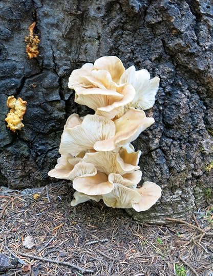
Highlights of the ascent were giant, beautiful fungi, and a Montezuma quail – my first! That quail simply refused to fly away – it kept hiding behind clumps of bunch grass only a few feet off the trail, where it kept bobbing its head up briefly to see what I was doing.
Just past the spring below the peak, the steep trail through the forest was blocked by a rope hanging from a ponderosa branch, about 20 feet above. Tied to it were 3 large carabiners, and there was another long rope wrapped separately around the tree trunk. Someone had obviously been camping at the spring, and had constructed this elaborate setup to lift their food out of reach of bears. But they’d walked away without it. This was the second time this summer I’d come upon things left attached to trees in the wilderness – a bad trend of careless forest users. I pulled both ropes down, coiled them up, and stashed them in my pack to carry out.
I was really happy to find that the recent trail crew had cut a path through the dozens of logs blocking the trail along the crest. Despite my slow ascent, I was now determined to head for the distant saddle. I figured if the trail ahead continued to be passable, I had just enough time to reach it.
But what I found was perplexing – and much harder.
Past the saddle at 9,500′, a wide swath had been cleared through the thickets of aspen and locust, continuing down through the stand of fir that’d been blocked by dozens of deadfall aspen. On the other side, an eerie 8-foot-wide swath of trail had been completely cleared, like a firebreak, for a few hundred yards. Then it stopped, and the old path continued through locust thorns. My bare legs were soon bleeding from multiple scratches and I had to stop and pull my hot upland pants back on. Fortunately there was a good breeze blowing across the crest.
That’s when I realized I’d left my snake staff a mile or so behind – and I noticed I’d also lost the splint I wear to keep my trigger thumb at bay. This is only one of several health problems that have accumulated since the house fire, and I haven’t had time to treat properly. It has to be special-ordered and takes up to a week to replace, but over time the fit gets loose, and I wasn’t surprised it’d fallen off. It’s just hard living without it.
Descending the ridge, I discovered the trail crew had indeed cut through all the logs across the trail, but except for that short “firebreak”, they hadn’t done anything about the thorny locust overgrowing the trail and often completely blocking it.
I fought my way down and across to the farthest point I’d reached in the past, and kept going past that. The locust thorns just kept getting worse, to the point where you couldn’t even see a trail ahead.
Then suddenly another “firebreak” appeared – a several hundred yard clear swath, isolated in the middle of nowhere. It was welcome but didn’t make sense. Why would they clear these isolated stretches and do nothing with the rest of the trail?
It was taking much longer than expected and I was running out of time. I kept misreading the landforms ahead, thinking I was almost there, and that’s what drew me forward, despite how difficult it was.
Finally the trail switched to the opposite side of the ridge, and I could see what had to be the junction saddle, much farther ahead and hundreds of feet lower. I’d come too far to stop, so I kept going, through a broad burn scar choked with thorns.
I came to a forested rock outcrop, behind which, but much lower, I could sense the saddle. The vague trail continued down a deeply eroded bowl, then abruptly stopped at a big blowdown which was completely overgrown. Massive trees had fallen every which way across the trail, and locust had grown up between them, forming an impassable wall. The trail crew’s work ended here, only a few hundred yards from the saddle. It was amazing to get so close and be unable to go any farther!
Still, from the rock outcrop, I had a great view across the spectacular, almost inaccessible big canyon I’d fought my way into earlier this year.
I was now way behind schedule. I try to get home by 7 to warm up leftovers for dinner, but it was now looking like, despite getting an early start, I’d be 30 minutes to an hour late. I’d been wondering all day if I’d get any rain to further test the new pants, and working my way back up the ridgeline, I could see rain falling from heavy clouds a few miles to the north. An occasional crash of thunder reached me, but the storm didn’t seem to be moving my way.
It took just as long to fight my way back up that ridge as it had to fight down it – exacerbated by the 1,500′ climb. Fortunately my insomnia hadn’t caught up with me – I still had plenty of energy. And even wearing those hot pants, the ridgetop breeze and sporadic cloud shadows kept me relatively cool.
Finally I crossed the 9,500′ saddle and began my descent. Since walking too fast was regularly causing me pain, I paced myself. Halfway down the switchbacks I stopped at the big boulder pile to fill my water bottle. I happened to glance down, and there was my thumb splint! Out of the dozens of places where I stopped on this hike, I’d lost it here, and by accident, found it here hours later!
When I reached the canyon bottom, the swarms of flies found me. I picked up another branch to probe for rattlesnakes, but when I reached the spot where they’d been in the morning, didn’t find any.
It was only a few hundred yards farther that the familiar rattling started. There was a huge rattlesnake a few yards away, in rocks above the trail on my right. I photographed it and continued, but another rattling started immediately, below the trail on my left. There were two of them – they must be the same pair, on opposite sides of the trail, just as before! I’d never encountered this many rattlesnakes before – as much as I hike, I usually only see two or three a year.
I wasn’t walking slow, but I was really going to be late. I realized I wouldn’t get home until after 8, and I’d be exhausted.
The sun had just set by the time I reached the vehicle, but it was still plenty light out. I offloaded my gear into the right places and dug my iPad out of hiding so I’d have music on the hour-plus drive. Finally I got into the driver’s seat, belted up, and felt my shirt pocket for my sunglasses. They weren’t there!
I checked all around the front seat and in my duffel bag. I got out and looked under the seats. Nothing. I freaked out. I’d paid $150 for those, out of desperation, on my recent trip to Indianapolis. I’d tried cheap sunglasses from the drugstore in Silver City but they hurt my ears. I’d looked at REI in Phoenix, enroute, but they only had a half dozen pairs on display, all over $200. Sunglasses are surprisingly hard to find if you don’t live in an affluent neighborhood in a huge metropolitan area.
I got out of the vehicle, opened the rear door, and scanned the ground all around. Then I trudged up toward the trailhead. I knew I’d been wearing them on the hike back – maybe I’d absentmindedly dropped them near the trailhead. But I’d left the vehicle running – first I’d have to go back, turn it off, and lock up.
It was on the walk back to the vehicle that I spotted my sunglasses sitting on the corner of the rear bumper, behind where the rear door hinges open. That was a place where I never would’ve set them consciously or intentionally. There was simply no reason for them to be there. I guess the insomnia was finally catching up with me – not to mention the lingering PTSD, which often makes me feel like an idiot.
I was treated to a spectacular cloud show, amid occasional sparse showers, on the drive home.
I got back at 8:30. I was too tired to eat, so I just swallowed a shot of protein supplement and took a quick shower. I’d hiked over 16 miles and climbed over 5,000′, but it had taken me 10-1/2 hours.
August 17, 2021
Summer 2021 Escape
My temporary living space is dominated by a desk, covered with piles of paper. Each pile represents one of the 6-8 major projects I’m juggling simultaneously. It’s the elephant in the house – I can’t ignore it, as long as I’m in that place I can’t avoid that desk and the obligations, demands, and arguments I’m embroiled in as I struggle to get my life back.
Suddenly there was an unexpected hiatus over at my real, empty, fire-damaged, long-under-repair house – a flooring crew was refinishing the wood floors, and no other work could go on for a couple of weeks – hence I was experiencing no demands from, or arguments with, the contractor. Instead of rejoicing I fell into a deep depression. I still had so much to do, and so many deadlines to meet, and that desk still dominated my living space, demanding that I spend every day working. I literally had to escape, to preserve my sanity.
The only real option was the funky alpine resort village 3 hours north of here, where I’ve always stayed in the cheap, fishing-themed motel. All their rooms were empty at midweek, but the new owners refuse to communicate directly with customers, requiring all reservations to be made online, 24 hours in advance, and it took me two days of calling and emailing and fruitlessly exploring other options to learn this. And by then it was the weekend and they were all booked up.
But I was temporarily flush with “funny money” from insurance, and finally, I located a much more expensive 2-bedroom vacation cabin that hadn’t been booked yet – apparently the last lodgings available in the area. And the property manager actually answered their phone and happily took my same-day reservation.
Fortunately, since I was still following my COVID shopping routine of stocking up on two weeks’ worth of food in advance, I didn’t have to shop. I just had to pack, and this would give me a chance to test my new high-performance camping cooler – one of the few items of fire-destroyed camping gear I’d been able to replace so far.
I called ahead and made a reservation for dinner at the only restaurant in town, and raced up the mostly empty highway through the long series of mountain ranges between here and there. I arrived just in time to check in before the office closed. My heart sank when I walked in the little cabin, saw the furniture, and felt the beds.
The beds consisted of super-soft, 4-inch thick memory foam on top of thin, soft mattresses. When you put pressure on the beds, you seemed to sink endlessly down into them, which is the worst thing possible for back pain. Who actually likes soft mattresses? Fat people? And the living room consisted of an overstuffed fake leather recliner and a futon couch, both of which seemed to be designed for 7-foot-tall basketball players. The ergonomics of this cabin were far worse than the cheap motel room, whose pillowy bed had triggered an episode of severe lower back pain the last time I’d come up here.
But I’d learned my lesson back then, and hoped to avoid back pain now by sleeping only on my stomach, and sitting only on the straight-backed wooden kitchen chairs. There was no wifi, but that was probably a good thing. And the restaurant was only a 10 minute walk away on the gravel roads. It was cool up here, so I changed into warmer clothes and strolled over, carrying my rain shell just in case.
Part 2: Day of the FungidsThe next day was Friday, and I was hoping to hit my favorite nearby trail before the weekend rush. In fact, I realized I should now be able to do the full loop for the first time, hiking up one route to the top and returning down the other. It totalled 17 miles, but involved less than 3,000′ of accumulated elevation gain.
I drove the shortcut, the rough backcountry road through alternating mixed-conifer forest and vast grassy meadows across the rolling, 9,000′ plateau to the trailhead, where I parked next to a new, lifted Toyota pickup where two college-age guys were preparing to start a backpack. They were both at least six inches taller than me. All I had to do was shoulder my pack and lock the vehicle, so I took off while they were still getting ready.
I crossed the big meadows around the mouth of the East Fork of the Little Colorado, and stopped after about a half mile, as usual, to stretch, and to tighten and secure my bootlaces. The young guys caught up and passed me there.
But, also as usual, I was full of energy at the start of this hike, and soon caught up with them again as the three of us climbed through the fantastic sandstone boulders that are the highlight of this trail.
Halfway up this first slope, we passed a party of two young couples who were camping in the forest below the trail – only two miles from the trailhead. Like on my last trip to these mountains, I was surprised to find so many young people “slackpacking” – hiking only a short distance to camp near a trailhead, something my generation would consider pointless.
I was on the young guys’ tail all the way to the big rock exposure at the top of the ridge, and passed them where they had stopped there to take in the view. I knew there was a second rock exposure farther on, also with a good view, and I never saw them again.
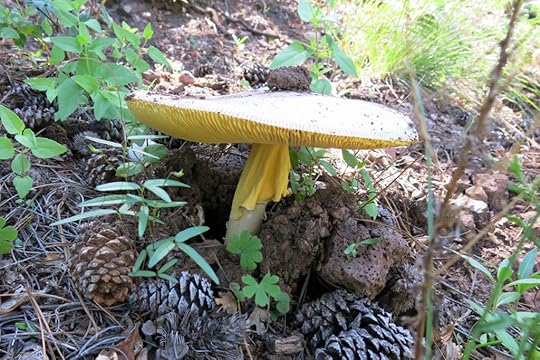
I remembered seeing a lot of mushrooms on my last visit here during monsoon season, but nothing like this time. Mushrooms were so plentiful they became the theme of the hike – especially the flamboyant Amanita muscaria. But the wildflowers came a close second.
From the big rock exposures at the top of the first ridge, the trail continues climbing the ridgeline through dense spruce forest with no views, so I kept racing upward. Near the point were I’d stopped and turned back on my first and longest previous hike here, I caught up with and passed a solo backpacker, another really tall guy, probably in his 40s. It made me wonder. I was doing this entire trail system as a day hike. There were no connecting trails, so why were so many people doing it as a backpack? It seemed at best only a one-night trip, which didn’t seem worth all the effort of backpacking. Sure, you could camp out at the crest, but there wasn’t any place to go from there except back down.
Shortly after passing the backpacker, I reached the burn scar near the top, where the east route becomes the west route.
This burn scar in spruce forest, at over 11,000′ elevation, is an eerie place, but during this abundant monsoon it was teeming with verdant shrubs and annual wildflowers, and water trickled down across the trail at many points.
Storms had been forecast for the whole weekend, but so far, although cloud cover came and went, I could see nothing menacing overhead. The temperature was perfect, which was probably lucky for me, as I was testing out a new pair of pants.
My regular pants were heavy cotton, and had been selected for thorn-resistance. But during this monsoon I’d suffered so much from waterlogged pants wicking moisture into my boots, so I’d spent some time researching both waterproof and thornproof pants.
REI and the other “hiker” brands don’t address this need at all – they assume their yuppie customers will stick to trails or climb snowy peaks devoid of thorns. REI staff in Tucson actually admitted to me, to their chagrin, that despite being in the arid southwest, they get the same inventory as their counterparts in Seattle. My only recourse, as with my boots, was to research the hunting suppliers. That’s where I learned that thornproof and waterproof pants constitute part of the “upland” hunting wardrobe – applying to hunters of non-aquatic game birds like pheasant and grouse, because they have to bushwhack through thorny thickets, often during storms or in heavy morning dew.
I’d ordered an affordable but highly-rated pair of U.S.-made upland hunting pants, and so far my only problem with them was the lining. It hadn’t been clear from the product info that they were lined, and although the pants had zippable side vents from knee to hip, the lining would probably make them really hot on most summer days in our climate. So I was doubly glad it was cool today.
After a half mile or so, the trail left the burn scar and re-entered intact spruce forest. And suddenly I was facing a glue grouse, pacing back and forth on a fallen tree trunk only ten feet in front of me. I stopped and was able to get my camera out – another recent challenge in itself.
I’d broken the lens assembly on my previous camera, and had spent over a month trying to find a replacement, and a way to protect the new camera from similar accidents. Whereas in the past I’d carried the camera alternately on a wrist strap and in a pocket, I was now wearing it in a holster-type case on my belt, where I tried to remember to slip on the wrist strap before pulling out the camera.
The big bird – they’re the same size as the average chicken – cooperated by remaining on the log as I took a few pictures. Then it made a noise and another grouse exploded out of the bush at my feet, and they both took off. It was the animal highlight of my trip.
This segment of trail left the mature forest and climbed gently through tiny meadows and dense groves of spruce seedlings, until it reached its high point in a saddle below the actual peak, which is sacred to the Apaches and off-limits to Anglos. At this saddle, I’d been hoping for a view over the vast country to the west, which descends for hundreds of miles to the low desert around Phoenix. But it was densely forested, and in rare peeks between the surrounding tree trunks, all I could see was more high, densely forested mountains in the near distance. So I continued down onto the outlying ridge above the canyon of the West Fork.
That outlying ridge finally brought me to a narrow saddle with an open view to the southeast – so I at least had a new perspective on the ridge I’d climbed in the morning. I’d climbed so fast that it was still early in the day, and I realized that if I didn’t slow down, I’d be done with the hike by midafternoon. I didn’t want that – I wanted to spend more time up here in this special alpine forest that is so rare in our Southwest.
Past the narrow, semi-open saddle, the trail began switchbacking down the very steep side of the West Fork canyon. Eventually it reached the head of the drainage in a burn scar where spruce seedlings were returning and wild raspberries were abundant.
Past the burn scar at the head of the West Fork, the trail curved leftwards through intact spruce forest into a big side canyon, where it finally crossed a robust creek. This trail may lack the spectacular rock outcrops of the East Fork – although there are plenty of boulders in the West Fork forest – but it actually has more varied habitat.
As part of my “slowing down” plan, I was paying even more attention now to my surroundings – primarily plants, fungi, and butterflies. In the stretch of trail past the side creek I saw my first coral fungus.
I was surprised to be feeling pretty sore and weary. To get back to the vehicle, I had to continue on this trail to its junction with the “crossover” trail, a 3-1/2 mile link between the trailheads. So no matter how much farther it was to the junction, I would still have those 3-1/2 miles to cross over.
But before starting the hike, I’d glanced at the elevation profile for the crossover trail, and had concluded it would be all downhill from this side. So at least I had that in my favor.
Eventually I started encountering meadows, which encouraged me to believe the junction was near. Each one ended up giving false hope, but at least I could see the West Fork meandering scenically below.
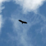
Finally, crossing a grassy slope high above the little river, I spotted a person far ahead. Then suddenly a bird flushed out of the meadow ahead of the distant person and shot overhead and past me. It appeared to be a falcon, which would explain why it was on the ground. When I reached the people who had flushed the bird – a couple a little older than me – I was so excited about the bird that I forgot to ask them how much farther it was to the trail junction.
After the falcon incident, I couldn’t ignore the pain in my left foot and right ankle. The right ankle pain was exactly like what I’d had in my left ankle a couple of years earlier. I was limping on both feet again, just like last weekend, and not looking forward at all to the crossover hike. I was transitioning from excitement about my beautiful surroundings into a “got to just survive this” frame of mind.
Fortunately it was only about a half mile beyond the bird incident that I met a college-age couple who pointed to the crossover junction, only a hundred yards farther. There, I crossed the rushing West Fork on a crude log bridge, and to my surprise, faced a steep climb on the other side.
In fact, I’d completely misinterpreted the crossover elevation profile. This trail was like a rollercoaster, climbing and descending hundreds of rocky feet at a time, sometimes at up to a 40% grade, through deep forest and across vast rolling meadows, over and over again, for the entire 3-1/2 miles between trailheads. In my condition, it was like some sort of legendary trial.
One of the few benefits of the crossover was the abundance of coral fungi.
The anticipated storm didn’t hit until I arrived back in the village, and even then it was only scattered showers. I changed out of my heavy gear and limped over to the restaurant, where I’d made a reservation the previous evening. This time I had a steak and a glass of pinot noir.
Part 3: Couch PotatoSaturday was about resting and recovering and relishing my time away from the terrible pressure of home. I had plenty to read on my iPad, and throughout the day, I did some long slow stretching and iced my foot and ankle at intervals. I knew how to treat my foot, but the ankle really worried me. It was swollen and my boots tightened right on the pressure point, so no more hiking until it healed.
There was one seemingly identical cabin next to me, but the folks staying there were having a near-continual party in their tiny back yard with a large group of companions from elsewhere in the village. And of course, the larger cabin across the road had a barking dog – it’s impossible to get away from barking dogs in this era cursed with social media.
I found that the futon couch was actually more comfortable than the bed – but to use it as a bed would require opening it flat, which would call for some brute force that would risk triggering my back pain. So I was stuck with things as they were. I’d brought fixings for a simple dinner at home that night, and went to bed early.
Part 4: Short Hike on a Poor TrailSunday was departure day, but I didn’t want to just race back home. I didn’t want to leave at all, and I’d considered staying an extra night, but back home, the city was resurfacing the street where my house is located during the coming week, and on Monday morning I had to move my truck off the street into the driveway all the contractors were using, arranging to switch with them. To avoid getting the truck towed, if I stayed here another night, I’d have to leave really early in the morning.
I had a few hours before checking out to study the maps, and I figured if I could attach some padding over the swollen ankle, maybe I could stop along the way for a shorter hike. I identified a few possibilities along the Arizona-New Mexico border.
While packing, I put on all my hiking clothes, applied biomechanical taping to my foot and a felt pad over the swollen ankle, and finally slipped into my boots. I tried to walk across the floor, but there was no way I could walk in those boots with that ankle. Damn!
I took off all the hiking gear, and changed back into my driving shorts and t-shirt. My sneakers were so low cut that they didn’t bother the ankle – I finally realized it wasn’t any kind of a strain or sprain, it was just some kind of pressure- or friction-caused inflammation. And then it occurred to me to try my other pair of boots, which I’d brought as backup in case the primary pair got wet.
My primary boots are designed for maximum ankle support – the shaft or collar of the boot, around the ankle, is reinforced. This is the part that is apparently irritating my ankles on long hikes. The other pair of boots are cut below the swollen area, so when I tried them on, they didn’t even contact it. I realized I could probably stop for a hike after all, so I set aside all my hiking gear for quick access in the vehicle.
As usual, I took the scenic route through the mountains before connecting with the highway home. It seems shorter every time – it’s so beautiful you don’t want it to end.
Back on the highway, the first turnoff I tried was at a pass between Alpine and Luna. It was a forest road I’d always wondered about, that claimed to lead to a fire lookout. It turned out to be one of those actually scary mountain roads – steep, twisty, rocky and deeply eroded, and strictly one-lane, with a deadly dropoff at the edge. The trail I was optimistically looking for was probably impassable – maps showed it crossed a large burn scar, and it hadn’t been maintained since the big wildfire – and the trailhead was almost 6 miles back on this road. The road went up, and down, and around, very slowly, and the first couple of miles took me 10 minutes, so I found a wide spot in a bend and turned around. Then I encountered a big truck coming up, and had to back uphill to the turnaround place to let them pass.
The next possible hikes were off a prominent backcountry road between Reserve and Glenwood, and would be my first exploration of the legendary Blue Range Primitive Area and Wilderness. I’d always wanted to explore this area, but it was simultaneously too close to and too far from home to be convenient.
It was a glorious day, like my first day of hiking. This area was a couple thousand feet lower than the alpine region I’d just left, with parklike pinyon, juniper, and occasional ponderosa over rolling hills at the foot of higher ridges and mountains in the near distance. I had two trails to choose from. The first was represented by an unnamed kiosk and had clear tread that beckoned up a shallow canyon. But from the map it looked too easy and didn’t seem to offer views.
The next trail was listed as “cleared” by a trail crew two years earlier, and appeared to climb a low ridge for a mile or two. There was no real trailhead – I was looking carefully at the roadside as I drove slowly along, and just happened to notice one of those little “hiker” icons on a post at an overgrown turnout. There was no tread leading inward, only the vague, overgrown suggestion of an opening through the parklike forest. But when I took a few steps past the signpost, I glimpsed a faded wilderness sign on a pinyon pine far ahead. So I figured I would gear up and check it out.
It was well past lunchtime, and I decided to not only make a sandwich – utilizing my new cooler as a table – but to drink a beer as well, breaking my usual habit of not drinking until the evening. Nothing says vacation like drinking in midday, and especially before a hike!
This trail turned out to be mostly forgettable. No one besides trespass cattle had used it in ages, and the surface was my most hated local footing – a mix of embedded and loose volcanic cobbles that is maddening and dangerous to walk on. Marked frequently by cairns, the route climbed the ridge at a generally shallow grade, mostly exposed so despite the mild temperature I was sweating pretty bad. But I was determined to get as high as I could, in hope of some kind of view.
The main attraction of that view turned out to be behind me – the peak with the fire lookout at the end of that scary road I’d given up on the way here. It was about 5 miles away to the northwest, and was a pretty mountain with a complex mosaic of rocky slopes, forest, and meadows.
Marked only by its cairns, my route drifted in and out of a cleared corridor through the open scrub forest, suggesting that in some distant past there might’ve been a wagon trail. The path completely ended in dense chaparral at the top of the ridge, after only a couple of miles of hiking.
When trail workers reported this trail “cleared” two years ago, it was obvious that all they meant was that they’d checked it to the chaparral on top – there’d been no clearing required. And it seemed that nobody but me even cared.
On the way down I lost the trail at one point, where a false cairn beckoned me onto a game trail down a side drainage. After wasting 5 minutes on that sidetrack, I dismantled the fraudulent cairn and found the right track to continue back to my vehicle. By my standards it hadn’t been much of a hike, but at least I’d set foot in a new wilderness area and seen some new mountains.
I had a pleasant drive home as usual – apart from the minivan driver who wanted to race down the twistiest part of the highway, tailgating me dangerously, finally passing only to slow down in front of me on the straight part of the road as he drifted back and forth across the center line, probably texting on his smart phone. By that point I was relaxed enough not to care.
My home is always first and foremost a studio, an office, a workspace, so the only way I can take a break from work is to get away from home. This trip had been my first getaway – my first vacation – in almost two years. And it had been over two years since I’d visited those mountains. So on the drive home I was re-evaluating my relationship with that place, and my attitude toward it.
One problem I can see is that it has kind of an awkward combination of extreme beauty and overwhelming recreational culture. It’s kind of like a huge national park in which the visitors are widely dispersed instead of concentrated like they are in, for example, Yosemite or the Grand Canyon.
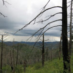
Despite its huge size, the area has historically far fewer hiking trails than the national forest in my backyard, and after the 2011 wildfire, only the half dozen most popular and easily accessed of those trails have been maintained. So all the hikers are concentrated on those few trails, none of which is particularly challenging. The trails in the large, rugged wilderness area at the south of the range have been abandoned and are essentially impassable, because that was the origin of the wildfire.
So for me, as a hiker looking for challenges and new discoveries, the area actually doesn’t seem to offer much.
But since the northern half of the range consists of those vast grassy meadows divided by hills and ridges with relatively open mixed-conifer forest, it suddenly occurred to me that off-trail hiking might be the solution. Maybe in the future I should just ignore the limited trail network and set off across country. I’m not sure how feasible that would really be, but it’s worth trying…
August 9, 2021
Another Easy Hike
After last Sunday’s soggy, painful descent from a downpour and long drive through a major law enforcement operation, I needed an easy hike near home. My fallback involved three trails chained together: a 4-mile up a lush canyon, another 2 miles ascending a peak on the Continental Divide Trail, followed by a 2-mile ridge hike to another peak. Round-trip distance would be 16 miles, all of it on well-maintained trails, with accumulated elevation gain of 3,500′ – less than I normally aim for.
It’s close enough to town that I almost always encounter other hikers, most of them venturing no farther than the head of the initial canyon.
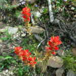
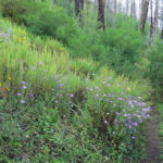
Our monsoon wildflowers were spectacular as usual – as I hiked, I catalogued the species I’d seen already and eagerly watched for new ones.
I passed two parties in the first two miles, but saw no one else until I was about halfway between the two peaks, up on the 9,000′ ridge. There I encountered a trail runner, an athletic guy now in his 40s whom I’d seen occasionally ever since I moved here. He used to be a technical mountain biker, and I was glad to see him off his machine and onto his feet.
At the second peak, I stopped only briefly. It was still early, I still had plenty of energy, and if I went straight back for the 16-mile round trip, I’d get home much earlier than usual. So I decided to add some mileage.
The best way to extend my hike seemed to be to return to the first peak and take the CDT farther north. I didn’t think it would add much elevation – it just snakes northeastward along a slightly lower ridge – but it goes through a burn scar so I should have some views over the landscape.
From the junction at the first peak, this unfamiliar section of trail traversed several hundred feet down an outlying ridge to a fire road. Much of it was on the edge of the burn scar and was overgrown with locust, but some shrubbier stretches had wild raspberries.
From the fire road, the trail enters a “moonscape” burn scar which has been taken over by shrubs and annuals, traversing the south side of a ridge, occasionally passing through surviving stands of pine and fir. I was planning to hike about two miles on this section of trail, so my final round-trip distance would be 20 miles. A lot of miles, but all of them on good trail. And later, back home, I would calculate that the ups and downs of this traverse would add 1,200′ of elevation to my hike, yielding a total of 4,700′ for the day – not too shabby!
Crossing the burn scar, every time I stopped I saw a dark cloud growing over the first peak, now a mile away on my right. Rain had not been forecast for today, but I knew that storms often form over the mountains even when it’s dry in town. In reality, during this monsoon, every time I hike, I get a storm.
The blister on my toe from last Sunday was still healing. I’d made a felt ring around it which had kept it from hurting so far, but as I watched the storm grow nearby, I realized that if my feet got wet again, the 10-mile hike back to my vehicle could become very painful.
I stopped after 45 minutes on the new trail – my measure of the two mile distance – and sure enough, shortly after I turned around, the storm hit me.
Rain poured down, lightning flashed and thunder crashed, and while the poncho kept my upper body and pack dry, my pants and boots were soon soaked. As always, I had spare socks, but I’d have to wait until the rain stopped to change. And it didn’t stop until 45 minutes later, when I was on my way down from the first peak.
By that point my toe was so bad every step felt like a nail driving into it, and my pants were so soaked it felt like I was carrying 5-pound weights on each leg. I had to pour the water out of each boot, and as in the past, used my spare bandannas to dry my feet and sponge water out of the boot linings.
I had spare felt in my pack and made another blister protector. But my pants and boots held so much residual water that after another mile of hiking the second pair of socks was soaked and my poor toe was on fire again. Now, after 15 miles of hiking, the chronic injury in the ball of my other foot had been triggered, so I was limping on two painful feet, and still had 5 miles and 2,000′ to descend. I had no recourse but to pop a pain pill. Like most of my monsoon hikes so far, this “easy” hike was turning into quite an ordeal.
Two miles farther along the pain in my toe was so bad I had to stop again, take off my boots, wring the water out of my second pair of socks, and apply a dry piece of felt to the toe. That enabled me to limp the remaining 3 miles to the vehicle – and fortunately from there it was only a 20 minute drive home!
August 2, 2021
Cloudbursts & Torrents, Thunderclaps & Gunshots
At this point, we can all expect Max’s next hike to be an adventure. But some more than others.
It’s August already, so I can go ahead and admit that this is one of our best monsoons ever. Meaning that every week, I spend hours cleaning and reconditioning my gear after sweating in high humidity and getting soaked in yet another thunderstorm.
It was finally time to head back to Arizona. My last experience of chaining together both maintained and abandoned trails hadn’t worked out, so this Sunday I wanted to stick to good trails. There were really only two trailhead options over there, and I’d hiked my favorite in June. The remaining trail definitely wasn’t my favorite – it involved a very steep initial climb and a long, high traverse that was completely exposed, ending at a bleak saddle. But the day was forecast to be mostly cloudy – which probably meant storms – and I figured I could vary this hike by extending it a mile or two onto a part of the crest trail I hadn’t hit before. The upper part of the hike would have absolutely no protection from storms, but I should be used to that by now. And if I returned early enough, there’d be a red chile pork burrito and a local IPA waiting for me at the village cafe.
I made good time on the highways, and there were only a few small cumulus clouds shifting over the range amid a crystal blue sky. But I knew that would change.
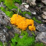
The first trail zigzags up a densely forested canyon bottom, crossing and recrossing a creek which was running strong from the past month of good rain. With few or no stepping stones, crossings are tricky, and I fell once – fortunately backward onto the rocky bank instead of into the water. The clouds were coming together and darkening overhead as I finally began the steep climb out of the canyon, through dense oak scrub. It was a good time for wildflowers, butterflies, fungi, and slime molds.
It wasn’t hot, but as usual it was so humid my shirt was soaked by the time I reached the forested upper slopes. A glance back at the northern part of the range showed rain already falling only a few miles away. The humidity slowed me down so that it took almost two hours to climb the first three miles and 2,000′, and when I moved onto the second trail in the chain and entered the pine “park” at the halfway point of the day’s hike, the sky ahead was low and dark. I realized the storm would hit me on the exposed traverse.
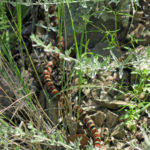
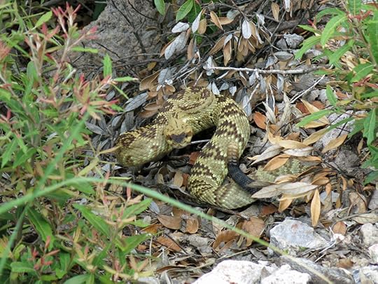
The arms of the storm were surrounding me as I began the traverse up the side of the long, deep canyon – three thousand vertical feet between crest and bottom. Near the beginning I suddenly saw a familiar pattern beside the trail ahead – a diamondback rattlesnake. It was full-grown, its body extended toward me, and its head was covered by vegetation only a couple of feet from my forward boot. Not a good position. I backed up just as the snake snapped back into its defensive coil and began to rattle.
I couldn’t pass it on the trail, so I had to climb up the steep, brush-choked bank of loose gravel at the side, hoping I wouldn’t slip and fall right on top of the snake.
It was shortly after that that the storm hit, and I had to dig out my poncho. Rain quickly became torrential, and since there was no place to shelter, I just had to keep climbing through it. This was the heaviest storm I’d been out in this year. I had to keep my eyes glued to the trail, but lightning seemed to be striking on the ridges far above – the time between strikes and thunderclaps was reassuringly long.
It was raining so hard on this steep slope that each little gully quickly became a torrent I had to carefully step over, and bigger drainages had been reshaped into temporary banks of debris that were more treacherous than usual. I kept telling myself the storm would move away soon, but it dumped on me for almost an hour – two miles of climbing – before moving off east down the canyon.
I’d passed the switchback that bypasses a big rock outcrop, and was crossing the short but coarse talus slope when I realized my feet were soaked and it was time to change socks. The oversize fragments of talus provided a good changing bench. That delayed me another 20 minutes – again, I wasn’t going to reach my planned destination for the day.
On the final stretch before the bleak saddle, where a ghost forest of fire-killed ponderosa dots the slope, I heard a raptor shrieking, and assumed it was hundreds of yards away on the opposite slope. But it kept up its cry of alarm several times a minute, and scanning the nearby trees, I found it only about 50 feet away. As I kept hiking, it kept moving to perches near me – it must’ve had a nest in a rock outcrop near the trail.
By the time I reached the saddle at 9,300′, I was already pushing my schedule – the time I needed to return to the vehicle in order to get that burrito and beer. But I’d been here twice before already – I just had to venture farther on this hike, even if only to the junction with the crest trail, less than half a mile farther. That would give me a view into the next big watershed, justifying the day’s effort and discomfort.
There was a trail, but just barely. It started out through a vast stand of chest-high ferns, with just the barest trace of tread hidden among them. Of course they were all wet from the storm, and although my pants were soaked already, I knew all that additional water would soak right through my boots so my temporarily dry feet would be wet again soon.
As short as it was, it was an interesting trail. Past the ferns it climbed across a bare, dramatic rock outcrop, then through a tunnel of aspen seedlings, emerging above an old, broken concrete springbox where it met the crest trail.
Whenever I encounter a structure like this, many miles and thousands of vertical feet from the nearest road, I can’t help thinking of the poor equines that had to carry those bags of cement mix.
I followed the crest trail down to the next saddle, which overlooked the big canyon I’d hiked into in June. I was filling in my mental map of the range.
On the way back, the hawk rejoined me in the same place, crying its regular warnings. I was in a hurry now. I’d used up time I barely had and was still hoping to reach the cafe just before closing.
I pounded down that steep slope, ignoring my wet, worn-out feet and joints, as if my body were 50 years younger. I was timing myself and making much better time going downhill. Three miles later and 2,000′ lower, when I reached the pine park, I was right on time, but storm clouds were forming again.
A mile down the next, steepest trail, my right knee reached a crisis stage. It hurt to walk on and it was impossible to lift it to step over a fallen log. I’d never had trouble with that knee before, but I dug the knee brace out of my pack, strapped it on, and continued. It started to rain again under a mostly clear sky, but only lightly, and it stopped before I reached the canyon bottom.
I checked my watch again, and then it hit me. I’d made a really stupid mistake. I’d forgotten about the time difference – something I’d never done before, on dozens of trips. There’d been no need to hurry, because I’d cut my hike unneccesarily short, and I had plenty of time. I could’ve continued on that crest trail as originally planned. I slowed down, and brutally chastised myself, cursing my stupidity. All that work and pain, and I could’ve gone even farther without even rushing!
But I soon had more to think about – before I even reached the first creek crossing I came under another downpour. Now my right little toe was killing me – that fast descent in wet boots had raised a blister – and I could hear the creek roaring ahead.
Although I had to keep my head down in the heavy rain, crossing the flooded creek turned out to be fairly easy. I didn’t have time to think, I wanted to reach the vehicle and change into dry clothes, so I just crossed the damn creek in any way I could.
Just as I got fully naked in the half-open vehicle – in an empty overflow parking lot big enough for 12 cars, at the end of a very rough dead-end road way back in the mountains – an elderly couple in a Prius drove up and parked right next to me. I stared at them, hoping they’d get the message I needed some privacy, but they just smiled and waved as I laboriously pulled on my dry clothes.
A half hour later, I was sitting in the cafe enjoying my early dinner, among staff and diners blissfully maskless, when a dozen middle-aged fully-masked men and women, dressed like generic naturalists, burst rapidly through the tiny dining room and disappeared into the back, where as far as I knew there was only the kitchen and a restroom. They never reappeared.
After the big meal and the beer, I really wanted to book a room at the lodge. But I had yet another busy week ahead of me, so I hit the road at 7 pm New Mexico time.
The clouds were glorious. The sun had just set by the time I hit the highway north to Silver City, with no cars ahead of or behind me.
But I was wrong. Less than a quarter mile up the highway a big SUV filled my rearview, and it passed me, “SHERIFF” painted across the back. Then a rock hit my windshield and cracked it.
The sheriff’s car slammed to a stop ahead and whipped a U-turn, parking on the opposite shoulder, so I pulled onto the right shoulder, rolled my window down, and waved. The deputy came over and I showed him my windshield.
He said he was on a call – shots had been fired between vehicles on the highway ahead. But he spent about 15 minutes photographing my windshield and all my cards, and gave me a number to call. He was all amped up, and I wished him well. He told me to be careful, but didn’t stop me from driving on.
A little ways up the road the convoy appeared – a half dozen vehicles with lights flashing, speeding toward me – city police, county sheriff, state highway patrol. Past them, as it got dark, a half dozen more light-flashing law enforcement vehicles streamed past, one after the other. Finally, ten miles outside of town, there was a roadblock – but only on the opposite lane. I never found out what had happened, but I was kind of a nervous wreck by the time I dealt with my wet gear, showered, and climbed into bed.
July 26, 2021
Redemption Hike
Conflicting desires this Sunday. The weather was forecast to be cloudy and cooler – in the 70s. So this was a perfect time for a lower-elevation hike, for example over in Arizona where I could get a burrito and a beer afterward.
But for the past few weeks I’d been frustrated with shorter hikes and less elevation gain, so I felt I really needed a bigger hike today to maintain my conditioning. On paper, I’d been studying some possible loop hikes in various mountain ranges that would string together multiple trails. However, these loops all included trails that were abandoned or in bad shape. The problem with Arizona is that the longer driving time limits the time available for hiking. So for today, I decided to try a loop close to home, involving two trails I knew to be in good shape, and one that appeared to be long abandoned, with no info available on its condition. As usual, I was just going to take my chances.
Driving west of town, I could see clouds literally hugging the low mountains ahead. We’d had a lot of rain the past week, and both air and ground were saturated.
The hike starts with a two-mile stretch, dropping into a canyon and following it up to the trail junction. As usual this time of year, the canyon bottom was a green jungle, but the creek was barely running. The branch trail, climbing over a ridge into the next, bigger canyon system, leads ultimately to an old miner’s cabin, and is maintained by the Arizona family of his descendents. The Forest Service reports this trail impassable, and at the junction it’s overgrown to the point of invisibility, but once across the creek, it turns into a good trail.
Entering the monsoon jungle of the first canyon I discovered an unexpected problem: heavy dew on all the vegetation crowding the trail meant that by the time I started climbing toward the ridge, my pants were soaked. This was a northwest slope, mostly in shade, so I was hoping that once I crossed over to the southeast side, sunlight from regular openings between the clouds would dry me off. Despite the cooler temps, it was so humid that my shirt was soon soaked with sweat and I had to keep mopping sweat off my brows as I climbed.
One unexpected benefit of this trail was the different perspective I got on previous hikes, which continued north up the first canyon. As I climbed higher, I could see that canyon was much rockier than is apparent from the trail, which sticks to the densely forested canyon bottom most of the way. Above the forest are numerous huge rock outcrops and cliffs.
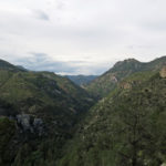
The miner’s cabin trail crests the ridge at a low saddle, where I had a great new view into and across the bigger canyon. This canyon is eight miles long and very rocky, and there’s no trail up it from its mouth like there are in every other canyon on this side of the range. You can only drop into it from farther up the sides, as on this trail.
The trail drops into the narrow side canyon of the north fork, which is where I hoped to pick up the abandoned north fork trail that climbed to a ridge, far back in the wilderness, where I would return on the continuation of the trail I’d left in the first canyon. The full loop would be about 15 miles, with nearly 5,000′ of accumulated elevation gain.
The clouds shifting around, covering and uncovering the peaks and ridges across the big canyon, made this a spectacular descent. Most of it had been burned in the 2012 wildfire and was exposed, through oak scrub, but I was relieved to find a little saddle halfway down, with parklike ponderosa forest. Descending past that, I flushed a white tailed deer.
From there the trail got steeper and rockier. I began to hear a roaring from the canyon bottom – this side must really be draining a lot of rainwater!
As I approached the canyon bottom, I checked my map for details of the junction with the abandoned north fork trail. It seemed to be close to the creek, but when I got to the bottom of the canyon it was very narrow, with steep sides lined with dense jungle. The cabin trail just disappeared – the only way down this canyon was via the flooded creek, through overgrown riparian vegetation. There was no sign of a trail junction, and this was no place to linger.
I double-checked my map, which was a just a low-resolution printout from a trails website. Now I could see that the junction probably lay 40-80 feet above the creek, so I began climbing back up the steep trail, carefully examining the right side for any sign of an old branch. After a quarter mile of climbing, I was about 120′ above the creek and had only seen one faint game trail that might be worth exploring, so I climbed all the way back down and tried it out. It disappeared within a dozen yards, and clearly wasn’t the old trail.
I spent about 45 minutes exploring all along that stretch of the cabin trail, bushwhacking several long side trips, and never found any sign of the old north fork trail. It’s just completely vanished. The only thing I could do was return, back over the ridge, to the first canyon. It was a steep climb and I was feeling exhausted and very sweaty as I headed over the saddle and back down to where I’d started, but at least the sporadic sunlight on the southeast-facing slope had dried the dew off my pants.
Approaching the original trail junction in the first canyon, I decided to make up for my aborted loop hike by walking up the first canyon trail a ways. I was pretty beat, so I’d just see how far I could get. I know this trail well, and figured I’d probably turn around at the base of the switchbacks that lead to the crest. That would give me another mile-and-a-half one-way and a few hundred more feet of elevation.
Not far past the junction in the first canyon, I surprised a rattlesnake at the base of a log alongside the trail. It’s always surprising to find a western rattlesnake in such a lush environment. I carefully sidestepped it and stopped to look back and memorize the configuration of rocks and logs so I could watch out for the snake on my return.
When I reached the base of the switchbacks, a tiny clearing in creekside forest, I wasn’t feeling completely exhausted yet. So I started up the switchbacks, figuring I’d stop at the boulder pile before the long traverse up the other side. There’s a really steep stretch leading to the boulder pile, and I figured that would do me in.
But somehow I was getting a second wind! I breezed up the steep part and past the boulder pile. A trail crew had been up here recently and cut up all the logs that had been blocking the trail for the past couple of years, which made it easier. Now I figured I might make it to the end of the first long traverse, where you get a view out over the big canyon where I’d failed to find the abandoned trail. That would really give me some elevation to compensate for the aborted loop.
As it turned out, I was feeling so good, I not only made it to the end of the first traverse, but I continued onto the much steeper and more difficult second traverse, which brought me to the edge of the final ascent to the crest – as far as I got on my first hike on this trail, 2-1/2 years ago. I now knew this was turning into a respectable hike – true redemption for my failure to find the abandoned north fork trail over in the other canyon. Although the combined hikes would amount to a little less than 13 miles, my accumulated elevation gain for the day was now nearly 5,000′. After being pretty miserable a couple hours earlier, I was now elated.
I descended in late afternoon through a forest made magical by alternating low-angle light and blue shadow. It looked like some weather was coming in the west, toward the mouth of the canyon.
Sure enough, when I reached the rattlesnake’s place, it was still there, in exactly the same position, but now it was asleep. It must’ve eaten recently and was immersed in the long, slow digestive process.
Climbing out of the canyon toward the trailhead, I finally got a glimpse of rain, miles away to the south.
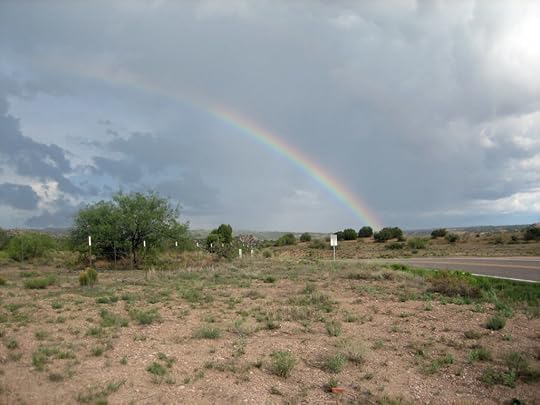
It just kept getting better. Light rain appeared on my windshield as I neared the highway, and when I stopped there to loosen my bootlaces, I saw a half rainbow to the south. Rain and rainbows kept shifting around as I drove south, and all the arroyos were in flood. A big storm hung over the Gila River where it emerges from the mountains, and it was way over its banks at the bridge. What a day!
July 19, 2021
Fright on Bald Mountain
We finally get a good monsoon, and it’s wonderful, but it just makes my already high-pressure life more complicated! Rain almost every day, heavy storms in the mountains, and while I’m only hiking twice a week, I spend the intervening days trying to get my muddy, water-logged gear – boots, pants, poncho, and hat – clean and dry. Everything ends up in good shape just in time to get filthy again.
This Sunday I knew it made sense to head over to the newly opened west side of the wilderness, but as usual I was looking for unfamiliar hikes to spice up my routine. After studying the map I settled on two options, each of which had a high likelihood of failing. The first was a super-challenging peak climb that involved an undetermined amount of bushwhacking which I’d already sworn never to do again, and the second involved a canyon hike on a trail abandoned for almost a decade. The hike might fail, but at least I’d be out in nature.
The forecast was for cloud cover throughout the day and rain in the evening, but I’d seen how that played out last Sunday – lightning, thunder, and hail in the afternoon. The canyon hike would be a safer choice – the peak ascent would be scarily exposed – but on the drive up the west side of the mountains I chose the climb instead. When I’d attempted it before, I’d emulated a young woman from Arizona who’d started at the nearby canyon trailhead. That route involved a nasty bushwhack up a steep, brush-clogged side drainage to an old mine. Now that I had my 4wd Sidekick back, I could drive up the old mine road and save myself a mile each of trail and bushwhacking.
From the mine, it wouldn’t be a long hike as the crow flies – I figured about four miles to the peak I was aiming for. But that distance could be almost doubled by bushwhacking and circumventing obstacles, and in the process, I’d be climbing over 4,500′ – half of which I’d have to ascend in less than a mile.
In retrospect, it’s clear that I was still trying to compete with that young woman. It still bugged me that someone half my age could scamper all over our wilderness without needing trails, while I found it so hard and such slow going.
But my first challenge was getting up that mine road. It turned out to be the roughest road I’ve ever driven in this area – not as bad as our Mojave Desert mine roads, but reaching the limit of what my vehicle will do. I was in low-range 4wd the whole way, but hell, that’s what this vehicle was designed for, it’s about time I put it to good use.
From the graded road, the mine road climbs 1,200′ up and over a series of small peaks forested with pinyon, juniper, and oak, finally entering the ponderosa zone. The track is almost entirely rock, either embedded or loose, except for some steep parts that are loose dirt. The mine entrance sits halfway up a small conical peak blanketed by pine forest, but the road continues past it, climbing to a saddle behind the peak. That’s where I was hoping to park and start my hike, but a quarter mile beyond the mine I met my nemesis – a rock outcrop across the trail that I tried to drive around, but lost traction even in low gear and couldn’t get over. There was no place to turn around, so I had to reverse a quarter mile down that narrow, heavily-eroded mountainside track all the way back to the mine. It took about 15 minutes.
In addition to the risks of the hike itself, in the back of my mind was whether I’d be able to drive down this road later, after a rain. There were some steep, deeply eroded stretches that would get muddy, and the rocks themselves would get slick. But I’d just cross that bridge when I got to it – worst come to worst I’d have to spend the night in my vehicle up on the mountain.
On the ledge outside the mine entrance, I got turned around, parked, and loaded up for my ambitious day.
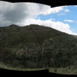
My destination was a 10,700′ peak at the end of a southwest-to-northeast trending ridge, the ridge itself averaging 10,000′. The little peak above the mine lay at the foot of a much lower outlying ridge, and the obvious approach was to traverse up the side of that outlying ridge to the saddle where it connected to the base of the higher ridge. That higher ridge began with a distinctive 9,800′ “bald” peak, so that would be my first goal, and likely my biggest challenge.
On the drive to the mountains I’d seen a broad but shallow cloud mass hanging over the heart of the wilderness, and elsewhere only scattered clouds with lots of blue sky showing. During the approach, clouds drifted back and forth, I had alternating sun and shadow, and it wasn’t hot, but it was humid enough that I was sweating pretty good.
Since I’d first attempted this climb, I’d done a lot more bushwhacking. I knew at least the first mile of this hike would be mostly through dense brush, but at this elevation – between 7,000′ and 8,000′ – it would be oak and I could just push through it. So that’s what I did, aiming for patches of ponderosa forest higher up the ridge where the walking would be easier. It was much slower than hiking a trail, but it wasn’t particularly hard.
Up and up I went, rounding broad slopes and cutting back into drainages, in and out of chaparral and small patches of pine forest, until I finally reached the ridge top that connected to the saddle at the base of the bald peak. This ridge top had a mix of open pine forest and dense oak scrub, so it was intermittently fast and slow. Finally I reached the saddle and gazed up at the daunting bald peak, with long talus slopes radiating downward on all sides. I’d definitely want to avoid those, but I’d also want to minimize my time in the dense chaparral in between the talus. This climb would put me literally between rock and a hard place.
The right-hand (east) side of the peak featured nothing but steep talus and dense scrub. The left-hand, west side was more complex, divided into big rock outcrops and cliffs, smaller talus slopes, patches of brush, and patches of forest. Hanging far above me was a broad cliff that I’d want to avoid, so I planned to wind my way up on the left, between rock outcrops and patches of forest – the way I remembered the young Arizonan had gone – hoping to find a “ramp” on the back side of that cliff that would lead to the top. It would all be very steep, but I figured I could take it at my own pace. After all, I had 7-8 hours to do a hike that at best guess might be 12 miles in actual round-trip distance.
After climbing the first few hundred feet I faced the first major obstacle: a cliff, and blocking my way around it, a narrow talus slope, both sides of which were lined with dense thickets of Gambel oak. I lost some time exploring routes through the oak and across the talus, but finally found a game trail that worked. The other side was much steeper, but the game trail held, eventually taking me to a little forested shoulder with an outcrop that projected dramatically over the big canyon to the north, where I’d done so many hikes in the past three years. Then, I’d always admired this peak from below and wondered if I’d ever climb it.
From there, I could see rain falling over another part of the range, a few miles away to the northeast. This added some urgency to my hike. I wouldn’t want to be descending some of these slopes when they were wet.
This small patch of mountainside forest opened up the next view, around the corner of the mountain, but unfortunately it was not the view I’d hoped for.
At first all I could see was another big, steep thicket of Gambel oak. But as I pushed my way through that, struggling for footing on the broken rock underneath, a much more daunting obstacle appeared. The entire slope ahead of me, as far as I could see, was steep talus, with only isolated strips of trees and brush breaking it into vertical strands. Above me was the sheer cliff, so my only option was to make my way across this talus. And since I was aiming for the peak, unseen somewhere far above, at some point I’d also need to resume climbing.
Real mountain climbers deal with this stuff all the time, but my experience with talus has been fairly limited, and none of it good. I always find it stressful, if not downright scary, to cross loose, sharp rock at the angle of repose, each step threatening to trigger an uncontrollable, potentially fatal rockslide. The only thing worse than traversing or climbing up a talus slope is having to climb down one, which I would definitely have to do on the way back.
It only took the first nerve-wracking traverse of talus to convince me to try climbing instead. A narrow vertical strip of brush and pines divided this from the next rockfall, and I used that vegetation to stabilize my climb. A few dozen feet up I encountered a steep outcrop I could climb on all fours, and that took me to a thicket I pushed up through, eventually reaching a small cliff that I could climb on natural hand-and-footholds. And suddenly I emerged on a tiny ledge at the top of the cliff, with a view over the southern landscape and the next big canyon system below the peak on the east.
That little rock ledge was part of a knife-edge ridge that seemed to climb steeply up toward the bald peak, which was still hidden from my perspective. It would be hard to follow as a route, because the knife edge was formed out of rough, irregular rock outcrops and densely forested with brush and pine. And it felt totally precarious and exposed – not a place to be stuck in a lightning storm or gale force wind. But getting here felt like a huge accomplishment! I’d managed to avoid most of the talus that had worried me below, and at this point there was nowhere to go but upward.
I slowly made my way up the knife edge, winding back and forth between outcrops, oak thickets, stunted pines and junipers, and occasional deadfall logs. Working my way up a small rock exposure surrounded by dense oak, I suddenly heard a rattlesnake somewhere to my right, but couldn’t see it, so I just kept climbing. A little beyond that, I emerged from a thicket at the base of another big talus slope.
This one was even scarier than the ones I’d found below, because the rocks were bigger, and there was literally nothing else above – I was nearing the top of the peak. But on the right was a dense wall of oaks, so I kept close to that as I precariously ascended the rockfall, and eventually the rounded “bald” top itself loomed ahead of me.
Faint “trails” led upward through the loose rock – impossible to say if they were natural, man-made, or game trails left over eons of time. The whole dome was crisscrossed by them, so I wound my way back and forth up the dome until I finally reached its small, flat top. So small, and so bare – like a stage elevated into the sky. The only feature up there was a tiny stone ring surrounding a Forest Service benchmark.
Looking east I could see the undulating ridge leading to the 10,700′ peak I’d hoped to reach today. That peak was still two miles away and involved descents and ascents of almost another 2,000′. It’d taken me 4 hours to get this far – I figured it would take at least another couple hours to reach that higher peak. The return would be a little quicker, but with storms obviously forming all around, it would still leave me descending a wet, extremely dangerous mountainside well after dark, which was definitely out of the question.
Now I felt really in awe of the girl from Arizona, and humbled by her achievement. But on the other hand, her hike had taken almost 13 hours, and she’d highlighted the slope I’d climbed to get here as the hardest part of the whole day – she’d said her heart was skipping beats and she was praying while climbing that talus.
I have to admit my sense of accomplishment was still tempered by a lot of anxiety – if not outright terror – about descending those steep slopes and re-crossing that talus. It was becoming more obvious how my hiking obsession was getting out of control and exposing me to risks that were totally unnecessary and probably counterproductive. Nobody should be doing hikes like this alone, ever, regardless of age or physical condition…
As it turned out, the down hike wasn’t as bad as I’d expected. I had to be super careful, but I managed to survive the cliffs and the talus and reach the little forested shoulder unscathed. There, I found really fresh bear scat – it seemed I’d just missed the bear. Amazing what climbers these animals are.
At that point I could see rain closing in from all directions, but it didn’t hit me until I’d crossed the saddle at the foot of the peak and began following the lower ridge to the point where I could start descending toward the little mine peak. When the rain did hit, it hit hard, and I soon found myself slipping and falling down a slope of loose dirt and broken rock, getting thoroughly muddy and plastered with leaves and sticks, snagging my poncho on branches that yanked me off balance.
Again I found myself in survival mode, just trying to make it back without injury. But part of my mind was also on the drive down that mine road. Could I even do it in the wet? I’d soon find out.
Then I made a wee mistake. Where the ridge connects to the little peak, I saw a trail that seemed to be a shortcut down to the mine. That trail led through steep pine forest into a drainage that was obviously the drainage the mine road crosses just before you reach the mine. But I’d misjudged the topography. It wasn’t a shortcut – it was at least as far as the route I’d taken on the way up. And eventually the trail disappeared and I had to find a route down a steep slope of loose dirt between more oak scrub, in hard rain with every gully turned into a cascade.
So I wasn’t a happy hiker when I reached the vehicle, filthy and soaked, yet again, from head to toe. Amazingly, the return from the peak had taken only 2-1/2 hours – the steepness and thickets had made it much harder to climb than to descend. But that time savings was offset by the long, slow drive down the wet mine road. Although it was tricky when wet and had to be taken very carefully, the Sidekick’s deluxe all-terrain tires handled it just fine.
Back on the highway, I was filled with an incredible sense of relief. How amazing just to return from something like that, alive!
July 13, 2021
Trail of Many Weathers
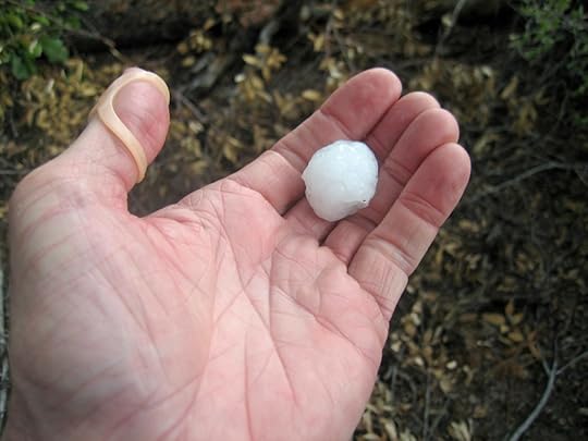
For more than a month my favorite local trails had been closed due to a wildfire that had simmered in the heart of the wilderness for weeks, only to flare up and rapidly grow during the hottest, driest days at the end of the pre-monsoon. The active edge of the fire was embracing the area I’d just discovered in April, and most wanted to revisit, so I anxiously checked the map for updates throughout each day. I wanted to explore a canyon, deep in the wilderness, that arcs from north to south for about eight miles, from the 10,000′ crest of the range in the north to its junction with a larger creek 4,000′ lower in the south. You approach the canyon from the west, across a high, rolling plateau, facing the canyon’s east slope, a dramatic, precipitous, continuous mountain wall studded with cliffs and giant outcrops of white conglomerate.
The fire, growing from the east, was sending an arm over the rim of that mountain wall in the north, and another around its base at the creek junction in the south. But then humidity increased across the area, and our monsoon rains started early, and the fire burned out just before reaching the canyon. And on Friday morning, after a week with no more wildfire news, I called forest headquarters across town, and was told the wilderness closure would expire at 5 pm.
At that point we were having rain daily, sometimes light, sometimes heavy. Temperatures Sunday were forecast to reach 90, and most of this hike is exposed to full sun. Rain wasn’t predicted until evening, when I’d be driving home, drenched with sweat. But monsoon forecasts are notoriously unreliable, and this forecast was for town. Hopefully the mountains would produce some earlier weather, and in any event I was desperate – I was an addict suffering from weeks of withdrawal.
On the long drive up the flat, overgrazed mesa toward the trailhead, I saw not the faintest wisp of cloud in the pale sky. And when I stepped out of the truck at the trailhead, it was into silence, stillness, and already oppressive heat. The log book showed that someone had beat me here, yesterday, but they’d only hiked a mile down into the first canyon and back. Parties from Arizona and Texas had hiked a little farther back in June, ignoring the closure notices. One of them reported too much blowdown on the trail into the second canyon – the trail I’d hiked in April.
In monsoon season, it’s no longer “a dry heat” – our humidity climbs above 90 percent. I was drenched with sweat within the first quarter mile, and when I finally reached the first canyon bottom, the creek was bone dry. The next stretch is a 1,400′ climb up a precipitous wall on long, steep switchbacks, gaining a dramatic view up a canyon lined with rock ledges and outcrops to the distant crest. The view was hazy from the heat and humidity, and the climb in the still, hot air was exhausting and took almost twice as long as usual. The only thing that kept me going was the belief that there would be water in the destination canyon, and some cloud cover in the afternoon, when during our monsoon, the day’s heat typically generates cumulous clouds that may grow into storms.
At the top of the canyon wall, the climb continues, even steeper at up to a 40 percent grade, to a small peak which is the west end of the rolling plateau that leads to the second canyon. Sweat was dripping off my head on all sides and I had to keep swabbing it out of the way with my already soaked shirtsleeves. I was crossing a high, two-mile-wide divide between two deep canyons, but with no forest cover and without even the hint of a breeze. I kept surveying the skyline in all directions, but never saw even the tiniest cloud. The bleached dome of the sky felt like a giant heat lamp.
The eastern wall of the second canyon beckoned me forward, hazy like a mirage, as I trudged across the high parts of the plateau, with their broken white gravel and scattered shrubs, down into the red sediment and sparse pines of the hollows, and back up again.
Finally I crested the saddle above the descent into the second canyon. It’s a 1,400′ drop – mercifully, with sporadic forest cover – but I was already exhausted from the heat and humidity, and couldn’t imagine climbing back up it at this end of this sweltering day. But I’d have to – I couldn’t come this far, and pass up a dip in the water of the creek far below.
Heading down from the saddle, I first encountered freshly broken branches on trailside shrubs – a standard trail marker from the Arizonans or Texans – and a single bootprint. Then the trail gets so steep you almost have to slide down, and you reach the first deadfall – there’s actually no blowdown on this trail. Any sign of the out-of-state hikers ended – this is where they apparently gave up and turned back. But I knew the deadfall on this trail is actually minimal compared to other trails in the area.
The descent, seemingly endless and almost continuously steep and rocky, divides into several distinct sections, some through dense riparian vegetation, others through chaparral, others through open pine or fir forest. The dramatic eastern wall looms in front of you the whole way, and when you finally emerge into the intact, shady ponderosa forest at the bottom, on an alluvial bench above the creek, it’s like coming home.
I’d been planning to explore the creek trail upstream, but first I had to fight my way through the dense willows lining the creekbed, to reach that cool running water at last.
The descending trail joins the creek trail in a broad grassy meadow at the feet of big ponderosas. I sat there for a while in the shade, snacking and drinking water. All the ice I’d added to my drinking water had long melted and it’d almost warmed to air temperature. So I soon got up and began following the creek trail north.
It hadn’t been cleared since the 2012 fire, but it wasn’t in bad shape. Very little tread remained, but there wasn’t much deadfall. I quickly reached the end of the alluvial bench, and the trail simply began traversing the steep, forested slope, diving into and out of gullies, climbing higher above the creek, which I occasionally got glimpses of, snaking over a bed of white rock dozens of feet below, tinted green with algae.
Rock formations closed the canyon in, and the trail suddenly dove down toward the creek between giant boulders. I’d been eyeing that water, and as I climbed down through the boulders I thought I could spot a swimming hole downstream.
Yes! There was an overhang for shade, and a clear pool that looked to be a couple feet deep. I’d started out hoping to explore much farther – two or three miles up the creek trail. This crossing was less than a mile from the junction, but the heat had really slowed me down. This would be my destination for the day.
The first thing I did was take off my sweat-soaked shirt and rinse it several times in the creek. With my chronic foot injury, it’s hard and risky for me to walk barefoot on rocks, so taking a dip in a rocky pool is complicated, but that doesn’t stop me – I just have to take it slow and easy. The water felt freezing cold, and as soon as I submerged in the pool I stirred up masses of dead algae, so I had to rinse off under the little waterspout that filled the pool. It was only a quick dip, but it felt wonderful.
I soaked my water reservoir in the creek to cool, filled a bottle with creek water to drink during the climb out of the canyon, and dunked my hat so it would keep my head cool on the way back to the junction.
It was during the hike back down the creek trail that I saw the first hazy clouds growing over the eastern wall from the southeast. By the time I reached the junction in the meadow there was an actual cumulus cloud hanging up there.
Still, the air remained incredibly hot and humid, and the steep climb out of the canyon was an ordeal that I could only handle in short stints. I just resigned myself to a very long hike back, and all the benefit of the dip in the stream was gone in the first hundred yards of that climb.
I kept looking up hopefully, measuring the spread of the cloud mass westward toward the sun in degrees of arc. I was probably about 2/3 of the way up before they finally met and I got some sporadic periods of shade, for the first time all day.
When I’d climbed 1,400′ out of the canyon and reached the saddle, the eastern sky had turned a dark blue and I could hear occasional thunder.
Things changed quickly as I started across the rolling plateau. Still air was replaced by blasts of wind, and after descending hundreds of feet into the first red hollow and climbing back up onto the second white shoulder, sporadic drops of rain turned to the sharp impacts of hail. I pulled my damaged poncho over me and my pack, just as I could see hailstones bouncing off the rocky ground between the shrubs.
Suddenly a bigger hailstone fell at my feet, exploding on impact. Then another landed on the trail ahead, 3/4″ in diameter. I knew there was practically no limit on how big they could get, so I started looking for trees to hide under, but there really weren’t any on this exposed plateau. Lightning struck all around, thunder crashed, big hailstones rained down on me, and I kept going. And within ten minutes or so, the storm moved off.
Since I was on a high plateau surrounded by peaks and ridges stretching many miles off into the distance, I could watch the weather moving around for many miles. I could see columns of rain thousands of feet tall. Up in the recent burn scar on a distinctive peak several miles to my south, I could see a patch of what looked like snow in July – a spot where hail had fallen heavily and piled up on ground cleared of vegetation by the wildfire.
I got to a point where I could see north across several outlying canyons and ridges to where lightning had struck high up a distant slope, igniting a small wildfire that raised a narrow stream of smoke.
Finally I reached the little peak at the western end of the plateau and began my grateful descent into the first canyon. Despite the storm, the air was saturated with humidity, and I was still soaked and dripping with sweat.
The downside of this spectacular trail is how steep and rocky it is, and the final stretch, more than a mile of traverse up out of the first canyon, is like adding insult to injury. Slowed by the heat, I’d spent over nine hours on the trail to cover less than 14 miles, but fortunately there was a bottle of ice-cold water waiting for me in the truck.
July 4, 2021
Wet Enough?
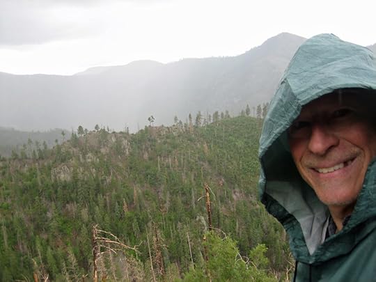
What is it about this year? First, the summer solstice fell on my hiking day. And now, the 4th of July, the day Americans celebrate the violent founding of their colonial state by blowing things up.
There was no way I could get away from my fellow Americans on this day, they’d be swarming all over the backcountry – except for our wilderness area, which was still closed, despite the big wildfire having been snuffed out by monsoon rains. Almost all of my favorite hiking areas had been off limits for over a month now, and I was getting desperate.
One trail remained open, far to the north, another two hour drive from home. It traversed some of the worst burn scars from the 2012 wildfire, near the crest of the mountains, gradually descending into the headwaters of the longest and most dramatic canyon in the range. The Forest Service listed this trail as “cleared”, but I’d tried it a couple years ago and found it badly eroded and blocked by some nasty deadfall.
However, since then I’d hiked much worse trails, so maybe I should give this one another chance. In general, I prefer peak hikes rather than canyon descents, but the climb back out of this canyon didn’t look too bad on the topo map.
We’d had a week of cool days with light rain – typical monsoon weather, but a little too early. The old timers say “rain in June, poor monsoon”. Sunday was forecast to be warmer and drier, and most of this hike would be exposed on a south-facing slope, so I packed ice in my drinking water reservoir again.
However, when I finally reached the mountains, the air was cool and storm clouds were forming. The access road passes through the little ghost town, and then becomes a very rough, steep dirt track that twists through dense forest and climbs 2,000′ in a few miles. After the first mile or so I was surprised to pass a young woman dressed in a stylish fitness suit, hiking up the road alone, carrying a tiny day pack.
At the trailhead I found three young guys, probably college students, camping and having a party. They’d gotten there in a tiny, 20-year-old Nissan sedan – I’m often amazed by the vehicles people bring on these backcountry roads.
The hike starts with a super-steep climb through dark fir and aspen forest to the top of a ridge at 9,000′, followed by a long traverse across moonscape burn scar, dipping into remnants of intact forest here and there. The first mile and a half turned out to be easier than I expected.
A dark mass of clouds had been forming straight ahead, over the highest part of the range, accompanied by the rumble of distant thunder. When the rain began it was light, and I didn’t pay it much attention because the hike was getting harder – the farther I went, the more deadfall and the more thorny New Mexico locust filling in the burn scars and choking the trail.
But suddenly rain began falling harder, and I had to stop and pull on my waterproof poncho.
Now I was hiking in a downpour, and everything got much harder. The deadfall logs were slippery and the footing underneath – loose dirt and sharp rocks – more treacherous. I had to slow down and use a lot more caution. The trail came to a deep gully containing intact forest, descending hundreds of feet at between 30 and 40 percent grade, then climbing up the other side. I suddenly realized my boots were filling with water – I could feel it sloshing back and forth. They’re made of leather and GoreTex and should be water-resistant – how was the water getting in?
I tried to speed up, but the trail was getting much worse the farther I went, and the storm was really dumping. Locust thorns started tearing my poncho apart, so I tried to stomp them as I walked, but they were just too thick.
These monsoon storms usually only last 20 minutes or so. I was hoping this one would end soon, and I could stop in the canyon bottom, drain the water out of my boots, and put on the spare socks I carry in my pack. They would get wet, but they were wool so they’d still keep my feet warm.
The rain did eventually fade, but shortly afterward, I reached a point where the trail just disappeared into a jungle of thorns and deadfall. If I’d been dry, I might’ve tried to penetrate it, but with my poncho torn up and my feet sloshing in water I was frankly miserable. And my last view of the canyon had shown it to still be hundreds of feet below me. I wasn’t anywhere near my planned destination.
I stopped there in the jungle, used a deadfall log as a bench, and spread out the damaged poncho on the ground underneath. All my clothing was soaked. The only thing I had that was dry was the spare socks and three bandannas in my pack. I took off my wet socks and used two bandannas to dry my feet and sop as much water out of the boots as possible, then put on the dry socks, and had lunch.
I’d really been looking forward to reaching the canyon bottom – there’s supposed to be a nice meadow there where backpackers camp. This spot in the jungle was ugly and I hated to just turn back, but I really had no choice.
As I headed back up the trail, storm clouds were parting, opening up patches of blue sky, and re-forming in the distance to the west. I could see a veil of rain hanging over the mouth of the canyon, a dozen miles away. I knew I should be grateful we were having this rain, but I was just bummed about going home early from another failed hike.
While I was returning up the trail, and watching the weather developing to the west, another mass of clouds was forming behind me. For some reason, I’d assumed I wouldn’t have any more rain today, but I was wrong. Just as I began crossing the deep gully with intact forest, drops began to fall, and as I climbed the steep slope out the other side, the rain fell heavy on me again. I pulled the wet, torn poncho out of my pack and pulled it back over me and my pack. By the time I topped out of that gully, my feet were soaking wet again, and I still had a couple miles to go. I was not a happy hiker.
Between climbing over logs and pushing through locust thorns, I gazed down at my boots, and suddenly realized that the GoreTex on the “tongue” of the boot simply wasn’t working. When the boots are laced, the base of the GoreTex tongue forms a little hollow, and rainwater was funneling into it and directly through the layer of GoreTex straight onto my toes. So much for “water-resistant” GoreTex.
There was nothing to be done about it, so I just kept picking my way carefully through the maze of thorns and deadfall. Lightning was striking all around me, every few minutes, followed by cracking, rolling thunder. And there I was in the midst of a burn scar, totally exposed, high up in the sky.
Eventually I crested the ridge and began descending through the dark forest, back to my truck. The rain faded to a drizzle.
The partying campers had left, but as I approached my truck, a late-model minivan came careening down the steep, rocky road, where it encountered a convoy of three big pickup trucks heading up. The first of the pickups stopped beside my truck, and the passenger window rolled down. There were two teenage guys inside, and the driver said something – I could only make out the word “truck”, so I stepped around my vehicle and said, “What’d you say?”
He spoke again, but so quietly it seemed he must be speaking to his companion instead of me. I walked up to their window and repeated “I can’t hear you.”
The driver looked embarrassed. “Sorry, we’re looking for somebody.” He smiled and drove off, the other vehicles following.
I loosened my boots – everything I was wearing was wet, I didn’t have any more dry clothes with me, and I would just have to drive home that way – all two hours of it, including the scary one-lane road from the ghost town.
Fortunately I didn’t encounter anyone on the one-lane road, but I did pass through some apocalyptic rain on the highway – twice. It rained so hard the road was flooded and I had to slow to avoid hydroplaning. Wet as I was, I felt lucky to get home safe.


