
Max Carmichael's Blog, page 24
January 24, 2021
Burning Fingers
It’s been a while since I posted a hiking Dispatch! Fear not, I’m still hiking. I’ve just been repeating hikes I’ve done so many times already, there was nothing new to report.
I expected this Sunday to be the same story. Boy was I wrong.
Sure, it looked like some weather was coming, for a change. We’ve had a disappointing winter so far – after a freak snowstorm in late October, nothing but blue skies, day in and day out. But when I got up Sunday morning, a little snow was forecast for the afternoon, and a lot more was forecast for Monday.
Just in case, I switched my 2wd pickup truck for the 4wd Sidekick, which I’d set aside months ago because the transmission was getting marginal. I didn’t expect any snow where I was going – farther south and lower elevation – but if there was anything on the highway when I drove back in the evening, the truck wouldn’t be able to handle it.
The horizon was obscured by clouds as I drove southwest, but the rest of the sky was blue. Imagine my surprise when I crested the pass and got my first view of my destination – the entire mountain range engulfed in a snowstorm!
I actually laughed out loud, and couldn’t keep from smiling as I drove across the big basin toward the mouth of the canyon. I was so sick of clear skies, the Southwest badly needs snow, and I was visualizing hiking through a magical landscape, well-prepared for anything in my winter outfit.
The only challenge I anticipated was getting enough mileage and elevation on this hike. The Sidekick would enable me to drive the 4wd road all the way to the trailhead, which meant I would need to add mileage and elevation somehow when I reached the crest trail – chaining together some spur trails, maybe climbing an extra peak. Shouldn’t be a problem.
By the time I entered the mountains and started up the canyon road, the storm seemed to have pulled back. I hoped it wouldn’t fade away.
But when I finally reached the trailhead, parked, and shouldered my pack, sleet was bouncing down through the trees and collecting on the wet ground.
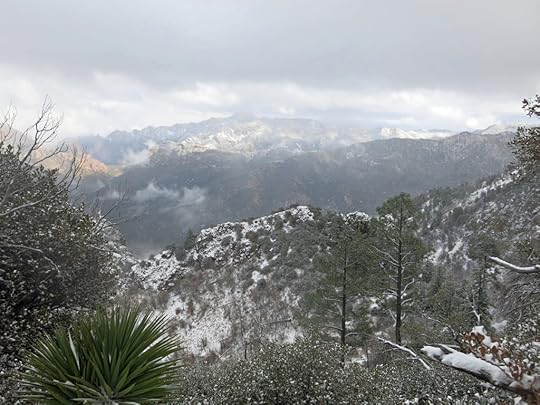
Sleet continued to fall lightly as I climbed the mile-and-a-half to the waterfall overlook, eventually turning to fine, granular snow. There was already old snow in shaded stretches of the trail, with somebody’s footprints. There’d been snow at high elevations when I last came here, in early November, but this must’ve fallen since.
The waterfall was frozen like last time, but with even more accumulation. I assume it stays frozen every winter, all winter long – it always reminds me how ignorant most people are about the Southwest. Nothing but hot sand and saguaro cactus, right?
Past the overlook, there was a lot more snow on the trail, a couple inches of fresh powder, and occasional patches of old snow underneath, still with somebody’s footprints. Mildly annoying – I always like to be first – but it’s been almost three months since I was last here.
I reached the mouth of the hanging canyon that feeds the waterfall and traversed toward the creek bottom. A lot more snow up here. As I approached the first creek crossing, I remembered how the creek had been frozen solid back in November. This narrow canyon bottom is apparently shaded all winter and stays very cold. And whereas the snow on the traverse had only been a couple inches deep, once I hit the canyon bottom, it was up to a foot deep. The frozen creek was completely buried. And I suddenly found myself in a blizzard.
Snow was blowing horizontal, straight in my face. The hood of my shell jacket has a nice overhang. I zipped it all the way up and cinched it down around my face. I walked with my head bent as far forward as I could while still watching my path. But no matter what I did, the snow still blew straight in my face.
The snow was so deep in this stretch that I started to get worried. Assuming I followed my plan, I’d be returning down this canyon four hours from now. After four hours of blizzard, there could be a couple feet of snow in this canyon.
This was not fun anymore. I wasn’t ready to give up, but I needed a break from the blizzard. After a half mile or so in the canyon bottom, the trail would climb back up the slope and traverse to the Forest Service cabin just below the crest. I seemed to recall the cabin had a little landing outside the front door, with a small roof overhang. If I could just reach the cabin, I might be able to shelter there, eat some snacks, drink some water, and regroup.
By the time I reached the cabin, I knew that was as far as I was going to get. This was ridiculous – the blizzard just kept getting worse.
And of course the cabin overhang didn’t protect me at all from snow that was driving at me horizontally. I gave up on my usual lunch and grabbed my emergency protein bar, but it was frozen! I had to break it with my fingers to get pieces small enough to chew.
Not expecting snow, I hadn’t brought my insulated Gore-Tex ski gloves. Until I left the cabin, I’d been wearing my wool glove liners and keeping my hands in the pockets of my jacket. After eating the protein bar I pulled my thick wool gloves on over the glove liners, but my fingers had already gotten cold.
I’ve nearly gotten frostbite many times in my life, and I swear it’s made my fingers so vulnerable that once they get cold, it’s almost impossible to get them warm again. I never seem to learn. All the fingers and thumbs were burning inside the double layer of wool, so I speeded up. I remembered how I’d survived the coldest night in recorded history riding an open boxcar over the Cascade crest in Oregon, by walking back and forth the length of the car hundreds of times. I began flexing my fingers and thumbs inside the jacket pockets. I was not looking forward to dropping back into the canyon bottom, but the trail was treacherous and I could only go so fast.
I just kept going and flexing my burning fingers. It took about 45 minutes to reach the mouth of the hanging canyon, flexing and burning the whole time. Not fun. At least the rest of my body was warm – I was wearing long johns and wool socks, and the Gore-Tex in my boots was holding up well.
The mouth of that canyon is an overlook in itself, sitting 3,000′ above the floor of the range, with a very steep drop-off. But everything was obscured by the storm when I got there. I could see clouds just beginning to recede from the opposite slope.
From there, the trail switchbacks down toward the waterfall overlook. And something miraculous happened. Shortly after I started descending, my fingers stopped burning. They suddenly felt fine. Even the air here felt warmer. That hanging canyon – which I’ve always really liked – seems to create its own climate, isolated from the rest of the range. In winter, it’s like a deep freeze.
Now I was pissed. I’d planned a 12-14 mile hike, but this would end up being little more than 7 miles round-trip. By the time I got home, I would’ve spent more time driving than hiking. What a waste.
But as I made my way down, the clouds began to open, revealing layer after layer of landscape. Blue sky and sunlight peeked through in places, spotlighting patches of forest and rock formations miles away. It was like an epic movie unfolding as I descended.
I love the way snow transforms everything in the environment, and of course I had a front row seat here – this snow had just fallen, I was the first to experience it. At least four inches had fallen during the past hour and a half – my ascending footprints had been completely obliterated. Lots of animals had crossed the trail since morning – javalina, deer, bobcat – even a fox chasing a rabbit.
As usual, I’d seen several flocks of dark-eyed juncos along the trail. And returning, near the trailhead, I came upon sections of trail where dozens of juncos had tramped all over the place, creating dense, intricate patterns.
There was only a couple inches of snow at the trailhead, and as I drove down the incredibly rugged 4wd road, I emerged from snow into rain, which continued on and off all the way home. I hope we get more!


January 6, 2021
Fire, Part 2: Discovering Wildfire
In early August of this year, I lost my home to fire. But it wasn’t the first time. Fire has welcomed me into its mystery since early childhood, and I’ve lost homes and other treasures to a variety of natural as well as human catastrophes. In weekly hikes, I’ve been studying how natural habitats and wildlife adapt to wildfire, and for the past two decades I’ve been planning to summarize my experiences with natural disasters in a series of thematic essays. So in the wake of the latest loss, here’s the second Dispatch on my life with fire.
Previous: Growing Up in Flames
Blinded by Smoke
To our amazement, shortly after Katie and I put out the woodrat midden fire and settled into our cave in the desert, we began finding prehistoric artifacts in our front yard – the sandy gullies and gravel banks between cacti, shrubs, gnarled juniper trees and boulder outcrops that surrounded us in all directions. Colorful, translucent stone flakes produced during the making of everyday tools, red and gray pottery shards, even a nearly perfect, impressively artful little arrowhead.
Even more astoundingly, when we met the new directors of a nearby ecological preserve, they showed us hidden “rock art” – petroglyphs and pictographs, pecked or painted inside boulder piles like ours.
As artists, we were already in love with the desert, but here was proof that other creative people had actually lived here long before us. Who were they, and what had happened to them? And above all, how did they live without cars, without the Von’s supermarket in Barstow? Everything around us took on new dimensions and raised new questions, now that we knew people had lived and created in this wild, arid place, getting everything they needed straight from nature.
These discoveries transformed our lives and work. Together, Katie and I began a passionate amateur study of prehistory, and the more I learned, the more I wanted to experience the prehistoric way of life firsthand. That’s what ultimately led me to the aboriginal skills school in Utah.
But meanwhile, I was learning, seeing with my own eyes, how our precious desert was under continual threat from people who saw it only as a playground, or as a wasteland ripe for development. I became determined to find a piece of land in the wilderness that I could own and take responsibility for. On a scouting trip in summer 1989, I rented a high-clearance, 4wd Jeep Cherokee to follow a maze of sandy, rocky, and deeply eroded old mining roads, abandoned for decades, deep into the heart of a remote, barely accessible mountain range.
Completely alone, years before the advent of cell phones, I drove the Cherokee miles up a narrow, boulder-choked canyon between steep ridges that towered 2,000′ above me. It was by far the wildest place I’d ever entered with a vehicle. Eventually I reached a place where the canyon was blocked by boulders, but there, the trace of another old mining road branched off to climb the bank of the dry wash. It was steep and so rocky and deeply eroded that I had to switch to low gear and drive at walking pace, but I followed it carefully up an outlying ridge to a level clearing, with the gaping hole of a mine visible far in the distance, at the base of steep cliffs that rose to the high ridge above. When I got out and turned around, I saw I had climbed hundreds of feet above the canyon bottom and had a spectacular view out over the center of the range to jagged ridges and peaks many miles away.
Dark clouds had been massing overhead, and the sun was going down. I built a campfire, made dinner, started a beer and smoked a couple hits of my drummer’s mild, high-energy pot. In the past year, I’d gone through the trauma of a breakup with Katie and the major effort of rebuilding my band and finding a new audience. We’d achieved success together, but it wasn’t the ensemble or the sound I wanted and I was creatively frustrated to the point of desperation. And my San Francisco loft, once a teeming community, was now down to only two from the original five roommates – just a big, echoing workspace and a lonely place to sleep. My heart was looking for a new home in the desert.
I’d never been so alone in such a spectacularly beautiful place, and I felt staggeringly liberated, humbled, one with nature, impossibly far from the city and the oppressive, conflicted culture we imported and imposed on this continent from Europe. I was even distancing myself in my wardrobe – I was wearing a pair of primitive-looking designer sweat pants from the Castro district, dyed in earth tones, and a pair of suede moccasins I’d picked up at an Indian trading post on a road trip with Katie. The low cloud cover was holding in the warmth of the day, and I pulled off my shirt and went for a walk down the road, to get away from the vehicle and other reminders of civilization. As darkness fell, I returned and went to bed on the ground, falling asleep with a head full of beautiful visions, way up there at the end of the old mining road, high on the exposed mountainside.
The next thing I knew I was coughing, waking in a blinding cloud of smoke. I couldn’t see flames, but using a flashlight I was able to quickly gather up my stuff and throw it in the Jeep. Not knowing where the fire was, all I could do was try to get away, and the only way out was back down the old road.
The survival instinct kicked in, big time, and although my heart was clenched in fear, my head was clear as I bumped and bucked the unfamiliar, unwieldy vehicle as quickly down the road as I felt was safe. Visibility in the dense smoke was only a couple of yards, but when I reached the canyon bottom my headlights lit up half a dozen terrified cattle, clumped silently together, their eyes glowing like coals in my headlights. They backed away from me as I turned and headed down the canyon.
I never encountered the actual fire. Miles later, as I drove out the broad, sandy wash toward the canyon’s mouth and the open desert, I finally emerged from the cloud of smoke. It takes the better part of an hour to reach the paved highway from there, and back then, there was a phone booth with a pay phone in the tiny settlement another 20 minutes up the road. It was about 4 in the morning when I got through to the county sheriff’s office to report the fire. Of course, it was burning deep in desert wilderness, 20 miles from the nearest ranch or house, and posed no real danger to anyone, so despite my breathless excitement, the desk officer who answered merely thanked me and said not to worry about it.
It wasn’t until a year later that I discovered the burn area while hiking the ridgeline more than 1,000′ above that night’s campsite. Dry lightning had apparently struck the slope on the other side of the ridge while I was asleep, and since there are no trees on that ridge, the dense smoke had been caused by the burning of widely scattered yucca trunks. Dense, fibrous yucca burns slowly, producing far more smoke than heat – I found that out the hard way.
Swimming in Wildfire
By a decade later, in 1999, I’d been hammered by more crises and traumas, more losses, poverty and homelessness. I’d been forced to set aside my dreams, my art, and my music to focus on finding a new day job. I’d eventually reinvented myself as a creative guru in the DotCom Boom, and although I was single, I was dating and wasn’t lonely anymore.
Big, high-intensity wildfires were becoming a more familiar news item in the West. One fall weekend my drummer’s girlfriend talked us into an overnight camping trip on the dry inland side of the coast range north of the San Francisco Bay. We may or may not have known about the wildfire in advance, but we surely saw the smoke and encountered emergency vehicles as we drove up the valley of Cache Creek and its tributary, Bear Creek.
But in those days firefighting agencies had a much more casual attitude toward public safety. Despite the fire being only a ridge away, the road was wide open. We drove farther north to a gravel road that climbed over a high ridge toward a remote reservoir, and chose a campsite at the top of the ridge, where we could look down on the fire a few miles south of us. Seems insane now, but I guess we felt if the fire moved closer, we could keep driving ahead of it to the backcountry reservoir, where we’d surely be safe.
After watching the sunset, we made dinner and went to bed, there beside the road. As usual, dinner had been accompanied by a few of northern California’s best microbrewed IPAs, and a few hours later, Mike and I got up to pee. No moon, and countless stars teeming and twinkling above us. We walked down the road to where we had a view south. As the mountain’s silhouette fell away before us, the fire’s spectacle was revealed. Like hell mirroring heaven, a hoard of flickering rubies, cast carelessly across the vast, crumpled black landscape we’d crossed to get here.
There was no wind, and although only a few miles away, the fire didn’t seem to be spreading. So we went back to bed.
The next morning, we drove back down the canyon of Bear Creek. During the night, the fire had burned downslope toward the creek, charred tree trunks were still smoking, and flames were still running along the west edge of the highway. But the road was open and we could see no firefighters anywhere. We stopped at our favorite swimming hole and hung out for hours opposite the steep, ash-covered hillside, lined with the blackened skeletons of ghost pines, smoking and smoldering less than a hundred yards away.
The next day, back home, I had my first episode of severe lower back pain. Completely unexpected, it wasn’t triggered by injury or exertion – it just appeared out of the blue. I’ll always associate that wildfire camping trip with the onset of a condition that has gradually gotten worse over the years, nagging me almost continuously, regularly interrupting my life and occasionally sending me to the emergency room with unmanageable pain.
The Year We Lost the Deserts
A few years after acquiring my land in the desert – in that same canyon I’d been driven out of by smoke – I became friends with an older couple, a writer and an artist, who lived about 60 miles north of my place. Neighbors, in the far-flung society of the Mojave. Their compound was in a high-desert basin, lush with sagebrush and juniper, surrounded by colorful mesas and low basalt bluffs. It became one of the jewels of the new Mojave National Preserve, and I’m still smudging my home with pungeant sage I gathered there 20 years ago.
Then, in June 2005, it was struck by lightning. After decades of grazing by cattle, their trampling of fragile soils, and the spread of invasive Old World grasses, fire raced across the desert. Ranches, trailer homes, and Park Service infrastructure were at risk, and as usual, government agencies mounted a military-style response.
Ultimately the Hackberry Fire spread to 70,000 acres – the biggest wildfire on record in the desert. It burnt sagebrush and juniper all the way to the roots and sterilized the soil so that this precious habitat may never return.
My best friend from the Bay Area happened to be there at the time, on a camping trip, and literally stumbled upon the fast-moving fire while heading up a dirt road looking for a campsite. He had to give up and turn back, but at least he was able to send me a photo.
That wildfire was a wake-up call for us desert lovers. Another friend, the desert’s leading botanist, pointed out that despite cattle and other modern impacts, fire has always been part of desert ecology and evolution. But before, many of us had only seen invasive plants as a nuisance – now we knew they were capable of completely destroying irreplacable native habitat. That fire felt like a terrible loss, and a prominent conservationist called 2005 “The Year We Lost the Deserts.” Little did any of us know how much more was coming, and how much worse it would get.
Nothing But Forest
I was born and raised in the upper Ohio River Valley, a rumpled, mostly forested landscape of rounded ridges and deep hollows. The forest was the remnant of a mature, temperate hardwood forest that, when Europeans first invaded, covered virtually all of the continent east of the Mississippi River. We know about it from countless written reports of explorers, hunters, trappers, and pioneer settlers, as well as early natural historians. In their accounts, that forest, dominated by giant oaks, chestnuts, elms, and other deciduous trees, was staggeringly, almost unbelievably productive and diverse in resources for humans.
Of course, it was already inhabited, by the people we Europeans conquered, brutally slaughtered, and drove off their lands. Whereas Native Americans had thrived in those forests, relying solely on native plants and animals, we cleared the ancient forests for European-style farms and replaced diverse native habitat with a much smaller number of domesticated plants and animals we imported from back home in the Old World.
Now we take the patchwork of farms, factories, and cities in the eastern U.S. for granted, forgetting the forest ever existed, proud of our preservation of a tiny fraction in parks and preserves.
The American West has much higher, much more rugged mountains, which still feature completely different, predominantly evergreen and coniferous, forest habitats. My dad moved west before me, and even before following him out there, I spent decades’ worth of vacations exploring, camping, and backpacking in densely forested western ranges – the Sierras, the Cascades, and the high ranges of the Great Basin.
But it wasn’t until I discovered the eastern Mojave Desert in February 1982 that I felt truly at home in wild nature. Why? Why don’t I like forests?
The year after that historic fire in the desert, I followed my desert friends to southwest New Mexico, at 6,000′ elevation, with vast national forests and wilderness areas in the backyard. The southeastern end of a 16,000 square mile swath of mountains, rising to nearly 11,000′ only an hour’s drive away.
The Southwest is arid, but most of it is not technically desert. And unlike the angular, stony mountains of my beloved Mojave, these had a rounded silhouette, covered by a continuous blanket of dark green forest.
Our European legacy conditions us to expect and admire forest-blanketed mountains, and during the past century, we’ve come to accept the continuous forest as the natural, primeval state of western mountains. But I love rocks – growing up in the Appalachian foothills, I was always most attracted to the occasional rock ledge, cave, cliff, or outcrop that stood out from the forest.
Hiking desert mountains, I always had distinct landmarks in view, I could always tell where I was. I could walk along a ridge and watch the landscape shift around me in three dimensions, with farther ridges lined up into haze at the horizon. I could point to where I wanted to go, then get there and look back at where I came from. In dense forests, your horizon is only a few yards away – a wall of vegetation – and as soon as you enter it, you’re basically lost.
I retain an abstract respect for forests as an equally important sort of habitat. Sure, data shows impressive biodiversity in the prehistoric eastern deciduous forest and the Amazonian rain forest. But to me, forests in general feel monotonous, confined, sometimes a little oppressive. Unlike the Easterners or Texans who typically relocate here, it wasn’t natural beauty that drew me. In general, I found this landscape pretty boring.
However, it was my new home, and I had to come to grips with it. One of the earliest things I noticed was the relatively “pristine” state of nature. Most everywhere I hiked in California, native habitat had been invaded, degraded, and largely replaced by invasive plants. From the coastal eucalyptus forests in the Bay Area to the star-thistle-blanketed hills farther inland, from the tamarisk-infested desert canyons to the red brome-covered slopes above, the European conquest had turned California into an alien mess.
Sure, our New Mexico landscape included basins and floodplains that had been overgrazed in the 19th century, and still hosted herds of cattle. I even found feral cattle following hiking trails deep into the wilderness – here they call them “trespass cattle.” But in the mountains where I was hiking, the only invasive plants seemed to be the occasional dandelion sprouting on trails heavily used by equestrians, from seeds impacted and carried in the animals’ hooves. The forests themselves seemed almost completely natural, native, and primeval.
Southwestern habitat changes dramatically with elevation, as can be seen from far away. Blindingly white salt-covered playas may line the bottom of basins, surrounded by low desert scrub, gently rising to rolling grasslands. Mountain slopes begin with a narrow band dominated by low, spreading trees: pinyon pine, alligator juniper, and Emory oak. As elevation increases, Gambel oak, ponderosa pine, and Douglas fir enter the mix – our “mixed-conifer forest” – and the low, spreading trees gradually drop out. At the highest elevations, quaking aspen and Engelmann spruce join the pines and firs. And all these high-elevation trees can be found thousands of feet lower in well-watered canyon bottoms where cool air settles.
The more I hiked, the more I noticed variations. In many places near town, the mixed-conifer forests were jungles, densely packed with small-diameter trees, choked with undergrowth and fallen logs. But one of my favorite hikes climbed to a rolling, parklike plateau, with tall, widely separated trees and nothing but grass in between. Those are the places we Europeans are deeply, emotionally attracted to – not just because that’s where we supposedly evolved, in Africa – but also because it’s an easy landscape for us to navigate.
In 2016, I backpacked into a remote range in southern Nevada where I found a forest out of nightmares: pinyon and juniper trees with branches that interlaced from the ground up – an almost impenetrable maze. I found plenty of droppings from deer and elk, and when I eventually reached an open plateau on top I discovered it hosted a herd of feral horses. So animals had found paths through the maze, but this range had clearly been abandoned by humans long ago.
I gradually realized that some forests – particularly the parklike ones – had burned not long ago. Charred trunks and logs still remained here and there, seemingly taking forever to decompose. From my reading, I had a sense that wildfire as well as historical logging and other human impacts played a part in these forest variations, but how, exactly?
It now seems obvious that conifer forests in an arid landscape would be ripe for wildfire, but after I moved to New Mexico, we had a deceptive hiatus of five years without any significant local fires. Like everyone else, I came to take the continuous, dark-green forests for granted, assuming the conifer blanket was the essential, primeval state of this landscape.
Fire Seasons
Then, in 2011, the big fires began. The Miller Fire, caused by lightning, threatened the home of my artist and writer friends, burning 89,000 forested acres in the heart of our local wilderness areas. But it mostly spread at low intensity, and experts cited it as a success of the Forest Service’s new policy of prescribed burns to reduce fuels, replacing the old policy of full suppression.
Then the Horseshoe 2, allegedly started by illegal immigrants, destroyed an inconceivable 223,000 acres in the heart of the Chiricahua sky island, a treasured, world-famous range just across the Arizona border southwest of us. When the wind shifted around to the southwest, our sky filled with haze, we choked on its smoke, and our sunsets were red.
My favorite route between my new home and the California desert ran through the White Mountains of eastern Arizona. I came to love that high, gently rolling plateau at almost 9,000′ elevation, its lush, grassy meadows dotted with sapphire lakes, its distinctive volcanic peaks streaked with black talus slopes. Most of those peaks were blanketed with dense conifer forest, featuring giant moss-covered firs and spruce, and again, I accepted that as the natural order.
Then I heard about the Wallow Fire, started by careless campers abandoning a still-smoldering campfire. Over a period of weeks, it spread across almost the entire plateau, becoming the biggest wildfire in the history of the Southwest at 538,000 acres. The wind came out of the northwest much of that summer, so we were often breathing that smoke. Toward the end, when the fire was spreading into New Mexico, I couldn’t wait any longer, I drove up to where the road was blocked, and I could see active burning. I was heartsick to think of the loss of that habitat, and the suffering of wildlife.
So much had burned in one year, we hoped to get a break. But 2012 brought massive destruction to the high forests of our own local wilderness – the Whitewater Baldy Complex, sparked by multiple lightning strikes that grew together to span 298,000 acres, leaving our highest peaks and ridges gray “moonscapes” where all vegetation was destroyed.
I was hiking a small peak just outside of town on a weekly basis at that point, and only a month after the start of the Wallow fire, someone deliberately set a fire that destroyed most of the vegetation on that peak. The arsonist was never identified, and I was sad to lose trees that had become my favorites, even featuring on one of my holiday cards. My local hiking buddy was so upset she refused to ever hike that peak again.
But I was still studying ecology, and I’d gradually moved beyond mourning burned habitat. Yeah, I hated to lose trees that were my friends, but stronger still was curiosity about what would come next, how nature would adapt. Don’t mourn – learn.
It wasn’t just the Southwest that was burning: huge wildfires were spreading all over the West, and I could see a pattern emerging in society. Thanks to the massive scale of our impacts, general ignorance of ecological history, and inevitable over-simplification by the media, urban dwellers were developing a habitual response to wildfire: shock, sorrow, and anger.
In 2013, the lightning-caused Silver Fire destroyed 139,000 acres of high-elevation forest in the smaller wilderness area just east of us. I’d started doing weekend hikes to a 9,000′ peak just north of town, and in 2014, human carelessness turned its back side into a moonscape. “Only” about 9 square miles were incinerated, but wildfire was getting close to home.
Then came the break we’d been hoping for – after 2013, the big Southwestern wildfires went on hiatus.
At the same time, I was losing my mobility to chronic conditions becoming acute in one body part after another. First my right hip, leading to surgery in 2015, with two years of slow recovery. Then a long-standing foot condition crippled me in 2017, followed by another two years fighting back. In between, severe lower back pain took me out of service twice a year, for weeks at a time. And beginning in 2018, rotator cuff tears in both shoulders limited my ability to navigate rough terrain and jungly habitat. I kept working to bounce back, but for years I was mostly limited to short walks, many of them on city streets near my home.
I would never take my mobility for granted again. If I ever recovered, I would return to the mountains with deep gratitude, more motivated than ever before.
Next: Learning From Wildfire
December 28, 2020
Day of Clouds
One of those days when I wasn’t motivated. It was freezing outside, I had trouble deciding where to go, and the hike I finally chose was a long drive away. Fortunately, preparing for an all-day hike in the mountains is a complicated routine, so I just submitted to it, and the routine eventually got me out the door on time.
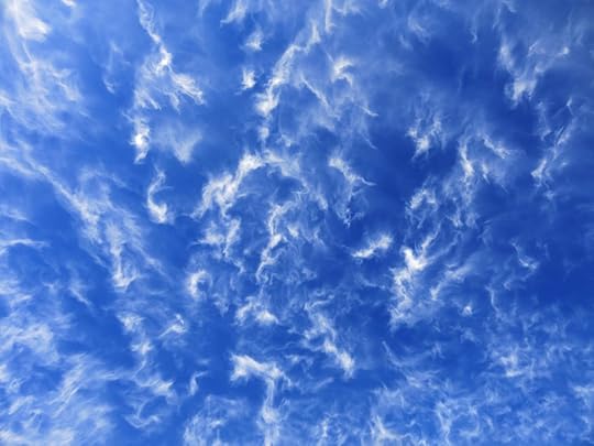
Funny, the sky was’t particularly interesting during the drive across the big empty basins of the Southwest. But once I arrived and started walking, something drew my eyes upwards, and the spectacle began.
No wind at ground level, but the clouds were churning constantly, all day long. Still, I had to keep my eyes on the ground while walking, and I was surprised to find a crowd of footprints – big, medium, and small, both coming and going – lining the trail from the beginning. I hadn’t thought this was such a popular trail.
However, the human prints disappeared after the first mile or so in the foothills. As usual, they were only up for a short stroll and had turned back. From there on, I had virgin trail – looked like no one else but animals had set foot on it since my last visit, seven weeks ago.
This is probably the most consistently steep hike I do. I’d forgotten how relentless it is. Southern exposure most of the way up, sweating. Then at the top, a knife edge ridge scoured by icy wind, legs aching, trudging in the chill shadow of towering firs up ground altering between crusty patches of snow and a pillowy sea of oak leaves.
Taking it easier on the way down. Love this Sky Island habitat – much more interesting than what we have back home. Especially in this canyon, where a maze of rock outcrops and cliffs forces vegetation into patches, alternating between dense chaparral and mixed-conifer forest, often interpenetrating. So much diversity! I kept exlaiming out loud, “What a great trail!”
December 23, 2020
Fire, Part 1: Growing Up in Flames
In early August of this year, I lost my home to fire. But it wasn’t the first time. Fire has welcomed me into its mystery since early childhood, and I’ve lost homes and other treasures to a variety of natural as well as human catastrophes. In weekly hikes, I’ve been studying how natural habitats and wildlife adapt to wildfire, and for the past two decades I’ve been planning to summarize my experiences with natural disasters in a series of thematic essays. So in the wake of the latest loss, here’s the first of three Dispatches on my life with fire.
Pyromaniac
Anthropologists who study mobile subsistence cultures – human communities that use open fires for heating and cooking – often observe that many adults have burn scars dating to their childhood, when getting burned was a routine part of living around fire and learning about its dangers.
I was born into a very different society: the suburban United States of the early 1950s. Only a few years before I was born, the U.S. had joined other imperial powers in a war that spanned the entire planet, and our victory in that war, and the industrial development that enabled it, had made us the richest and most powerful nation on earth, one of two new global superpowers.
The Good War. The Greatest Generation. Scientific discovery, technological innovation, industrialization, an orgy of violence and killing on a scale never seen before.
Almost overnight we had a worldwide military empire. And now: continuous, unending shows of force against our counterpart, in what was being called a Cold War.
Always hyper-competitive, we mobilized our scientists and engineers against the enemy in an Arms Race – stockpiling nuclear weapons – and a Space Race, rushing to conquer and dominate the skies overhead with rockets, satellites, and eventually “astronauts.”
But all our newfound wealth, power, and technological progress had a price: hanging over all of us was the threat of The Bomb, a wartime miracle product of our most advanced science – nuclear physics – that threatened to destroy all life on earth. At school, class was interrupted regularly by terrifying air raid sirens, and our teachers would hustle us out into the sterile hallways to hunch down in rows against cinderblock walls, arms crossed over our heads, eyes clamped shut, haunted by visions of a nuclear firestorm.
In contrast to our technological advances, fear made us socially conservative and conformist. My family lived outside a small college town, a center of high-tech industry, in a proto-suburb of modest, modern homes laid out in a row along one side of a road running up the narrow valley of a small creek, with forested ridges rising to each side. Each home sheltered another modern innovation, the nuclear family: our professional dads drove off to work early in the morning, then the kids got up and left for school, while the stay-at-home moms kept house, did the shopping, and cooked the meals. Smaller and more standardized consumer units, isolated from each other, resulted in needs that could be better commodified, improving efficiency and increasing profits for the shareholders.
It’s likely that I first became familiar with fire in our living room. My dad, a research scientist, wasn’t around much – he went straight to the bar after work, and came home late after I was already in bed – so he compensated each year in late autumn by conducting a little family ritual: collecting walnuts from under the trees alongside our house, building a fire in the fireplace in our small living room, and recruiting my mom and me to shell nuts in front of the fire.
Our house at the upper end of the row of houses, with the elementary school at the lower end. When I turned 7, a new family moved into the house next door, with a boy my age. We’d all been indoctrinated with the fever of space exploration, and he’d been given a working model of a multi-stage rocket ship like the ones being used to launch satellites into orbit. It looked realistic, but it stood only a couple feet tall and used water and compressed air for propulsion. It lacked much of the drama of the real thing.
All of our houses stood on terraces above the creek, with the front on the top level facing the road, and the back one story lower, with a basement opening onto a big concrete patio on the bank of the creek. Prosperity, conformity and predictability made society safe, and outside of school, kids were allowed to spend their days without adult supervision. My neighbor and I were sometimes left alone at the same time – our fathers at work, our mothers out running errands or visiting friends. On one of those days, bored with his water-powered rocket, the neighbor boy got the idea of collecting everything we could find labeled “flammable,” dumping it into an empty coffee can on his patio, and setting the mixture on fire, to simulate a real rocket launch.
We disappeared into our vacant basements and emerged a few minutes later carrying cans of gasoline, paint thinner, lighter fluid, and the like. My neighbor placed the coffee can out in the middle of the concrete slab, we poured a little of everything in, and he stirred it up with a stick. I stood back a few yards as he lit a match, tossed it in the can, and dashed back to join me. There was a subdued whoosh, a brief burst of flame, and that was it. Bad idea. Sheepishly, we returned all the ingredients to their proper places and moved on to something different.
Unfortunately for us, a lady in the next house over happened to be looking out a back window at the time. As soon as my neighbor’s mom got home, our spectator ran over to tell her. She interrogated her son, and he blamed everything on me.
My dad got the news at work, and rushed home early for a change. Our phone was ringing off the hook – all the neighbors in a state of hysteria, labeling me a pyromaniac, an arsonist, a dangerous juvenile offender.
I was undersize, and terrified of my dad’s temper. Obese, with a deep, bellowing voice, he always seemed like a giant. He interrogated me, but that only frightened me more, and I denied having anything to do with the backyard fire.
The other parents had chosen a dad from the lower end of our road as a representative, and he called my dad to announce their verdict. My dad angrily defended me, but the decision was final. Why? I’ll never know – over time, our family has lost all contact with that community.
Henceforth, I was not to be seen or heard socializing or communicating with any other kids on our road. And additionally: I was not allowed to set foot on their properties, which meant that I would have to cross the road in front of our house and walk to school on the far side, where there was no sidewalk.
Fire had made me an exile in my own neighborhood. I’d lied to my parents and felt terrible. I’m sure the neighbor kid was suffering too. I lost my playmates, and every weekday I carefully crossed the busy road and walked alone through the weeds on the other side, all the way down the valley to school, trying to avoid looking at my neighbors’ forbidden properties. It wasn’t until decades later, after our nuclear family had exploded across the continent, that the mother of the neighbor boy approached my paternal grandmother in a local supermarket and apologized, saying her son had finally admitted to starting that silly little fire.
Fanning the Flames
I was only an outcast for a year. In 1960, when I turned 8, my parents decided to separate, and my mom moved me and my new baby brother to her own hometown in the next state to the west. It was, in fact, only the beginning of my long migration west.
A new decade and a different environment. The Russians hadn’t bombed us into oblivion yet, so it was possible to start ignoring the threat of those growing nuclear stockpiles. And my mom’s hometown was a small farming community in the midst of flat, sprawling cropfields, almost an hour’s drive from the nearest city. Little industry, life had a slower pace, and progress and the wider world now seemed far away. Plus, instead of the “modern, progressive” nuclear family, I was now in the bosom of my mom’s traditional extended family.
My mom’s parents – my grandparents – operated a neighborhood grocery, and initially, we moved into their house, a short walk from the center of town in a tree-shaded neighborhood of small business owners and tradespeople. It was a modest two-story, three-bedroom wood-frame house probably built between the 1930s and the 40s, but it wasn’t really designed for all of us. After a year or two of this cramped arrangement, our grandparents moved around the corner into our great-grandparents’ house, and we spread out.
Our mom slept downstairs in the small parlor-like room off the kitchen, with a tiny half bath. I took the larger upstairs bedroom and my brother the smaller, and we all shared the only full bath, which was across a tiny landing between the bedrooms at the top of the stairs.
I was still an undersize child and was being bullied regularly by my new classmates and teachers, so if anything, I was even more fearful than before. My dad’s parents, back in our previous hometown, were insurance agents, and on some birthday or holiday they gave me a big book published by an insurance company, sensationalizing famous fires from history, with garish paintings showing people jumping out of the burning windows of big-city apartment buildings, and firemen running from burning houses with babies in their arms. I had developed a habit of reading in bed at night, and this book “fired” my imagination to the point where I was afraid of going to sleep and having the house catch fire with us unconscious inside.
I had only a rudimentary notion of how house fires got started. A spark or some source of heat in contact with something flammable? The only sources I could think of were the steam-heat furnace downstairs in the back kitchen, the electrical outlets and appliances, and the radiators and steam pipes located in every room. Every night, after my mom and brother had gone to sleep, I got up and prowled the house checking for hot spots. When I was sure everything was okay, I went back to bed and eventually fell asleep.
It took me another couple of years to get over my fear of fire in the night, but I finally did. Meanwhile, real fires were a regular spectacle in our town. The fire station had a horn that was so loud it could be heard all over town, and they divided the town into sectors. Whenever a fire was called in, they blew the horn from one to four times to indicate the sector, so spectators would know where to go to watch the fire. I’ll never forget the night the big grain elevator behind the courthouse caught fire. It was almost as tall as the courthouse itself, and much of the town’s population gathered on the courthouse lawn to watch the tower of flames and sparks collapsing into the criss-crossing arcs of water from the fire engines.
Midwestern summers can get really hot and muggy, and my brother’s room only had one small window, whereas my larger room had a couple of dormer windows next to my double bed and a taller sash window in the gable at the opposite end of the room, so I had a lot more airflow. Our grandpa had installed a big window fan in the lower part of that gable window, and on really hot summer nights, my brother left his room and joined me. On one such night, we had the fan going full blast, blowing directly at the bed, and it helped us both fall asleep.
The next thing I knew, I woke up to a roaring, crackling sound, and a wall of flame facing me across the room. I grabbed my little brother and dragged him out to the landing, where I yelled that my room was on fire. He bounded down to join our mom at the bottom of the stairs, and she rushed him out the front door, then dashed to the phone and called the fire department.
I followed my brother down, but my whole life was up in that burning room. I wasn’t going to let it go without a fight. I ran back to the kitchen, grabbing a big sauce pan and filling it with water, which I lugged back up the stairs, into a growing cloud of smoke. Choking and coughing in the heavy smoke, I could now barely see the fire, but I trudged forward anyway and threw the pan of water toward where I knew the window had to be.
Of course, that added a rush of steam to the smoke, and I was driven back down the stairs, where our mom was waiting for me, and we both ran outside, across the porch into the front yard where we joined my little brother under the big maple tree. Flames were climbing out my window toward the peak of the roof, and thick smoke was pouring out of the door and all the open windows, both upstairs and down. The fire station’s horn was blowing, a siren was howling up the street, and the fire engine was just turning into our alley. They stopped short of the house, ran a ladder up to the window, and a fireman began climbing it with a hose.
It only took a short blast from the high-pressure hose to put out the flames, and meanwhile, other uniformed firemen were tramping through our house, making sure the fire was truly out and all the windows and doors were open to let out the smoke.
Our grandparents accompanied us back to their house, around the corner. Our great-grandparents had both passed away by that time, so there was now a spare bedroom where the three of us could temporarily shelter. Our first order of business: to get clean. The window fan had had a plastic housing, which had apparently been flammable, generating black smoke full of molten soot and ashes that had coated everything in the house, including us, and my brother and I had been breathing it.
We were too filthy for the upstairs bathroom, which had only an old clawfoot tub, so we took turns showering in the unfinished basement, where our grandparents had their furnace and laundry room with a shower in the low ceiling. I remember coughing up long strands of black phlegm and watching them trail away to the drain in the concrete floor, seemingly endlessly, until finally the water cleared and I felt I could breath freely again. Decades later, a chest x-ray would show a scar in my lungs which may date to that fire.
The next day, we learned that the only actual fire damage was to the wall immediately around the window. But as always happens, our house was uninhabitable, because everything inside it was covered with that black soot, and the odor, the off-gassing, was toxic. Everything exposed – all our furniture, appliances, bedding, clothing, hobbies, toys, pictures – would have to be cleaned, and much of it would be unsalvageable. All the ceilings, walls, and floors would need to be cleaned, painted or refinished.
It was only a few years after the trauma of an entire neighborhood turning against me, but what a different experience this fire was! My mom’s hometown came together generously to support us, and all the cleaning and repairs were completed quickly. In my memory it was no more than three weeks before I was back in my upstairs bedroom, where the previous greenish wallpaper had been replaced with white paint, and the tongue-and-groove hardwood floor had a shiny new finish.
My clothes, bedding, books, and model cars had been cleaned, and it was great to be back in my own room, but I couldn’t get that wall of flame out of my imagination, and my nighttime fear of fire returned with a vengeance. Once again, I waited every night for the others to fall asleep, so I could prowled the house looking for hot spots. Only when I was sure everything was safe would I return to bed, but even then it was hard to sleep. So for a little more peace of mind, I arranged to spend one night a week in the spare bedroom at our grandparents’ house. Fire was redirecting my life.
Slow-Burning Cave
To people who live close to the earth, fire and flames are a mystical embodiment of spirit itself, and even in our advanced, civilized culture, we regularly use fire as a metaphor. In Cormac McCarthy’s Pulitzer Prize-winning post-apocalyptic novel The Road, the protagonist speaks of “carrying the fire” – the seeds of civilization itself – referring to our popular stereotype of cultural evolution: “man’s discovery of fire.” That civilization went through huge changes in the decades after my bedroom fire: the civil rights and environmental movements, Vietnam and the anti-war movement, the youth culture revolution of the 1960s and the Counterculture of the 1970s. And I finally had a growth spurt and gained confidence, and a small support group of kindred spirits, through my achievements in art and academics.
Beginning in the 1960s, candles became an icon of the new hippie generation, and in my high school art class, I made a big rainbow-colored candle in the shape of a long slab, like a stone wall, with half a dozen wicks in a row. Growing out of my early timidity, I’d begun taking on the role of an organizer and leader both in our neighborhood and at school, and at night, I’d set the big candle in the middle of my bedroom floor at night, invite friends over, and chant lines from ancient Anglo-Saxon poems – Beowolf, The Seafarer, and The Wanderer – as we sat in a circle gazing at the flames. On the eve of my departure for college, my experimental folk-rock band peformed its final concert on the open porch of a farmhouse way out in the country, surrounded by fifty flickering candles.
Our parents had split up when we moved to Indiana, but during our visits to his new home in California, our dad took my brother and me camping. His approach was incredibly stressful, with multi-page checklists and tons of expensive gear that had to be kept spotless and meticulously maintained, but he always said that nature was his church, and after I eventually transcended the uptightness and inhibitions of his approach to camping, the love and respect remained, along with many essential lessons, including how to safely and effectively build and manage a campfire.
As an overachiever in high school, higher education was inevitable for me. But when I left my small town for college in the big city, I also left behind the bullies, and slowly – very slowly – overcame my childhood fears, eventually emerging as a fairly confident, ambitious adult.
One aspect of that was rebelling against authority, whether in the form of my dad or my formal education. Attracted by the bohemian lifestyle, I became an apprentice to my best friend Mark, a fellow artist, who practiced a casual, minimalist style of camping. You always carried a sleeping bag and slept wherever you found yourself – in somebody’s living room, yard, or under a bush in a park. We spent years making road trips together, all over the west and into Mexico, huddling around campfires, surrounded by six packs of cold beer, passing handrolled joints, dreaming up art projects, making up songs and phantasmagorical banter.
When I graduated from Mark’s teachings and created my own arts community in a loft in San Francisco, we were hit by the coldest winter on record, and I bought and installed a wood stove which became the center of our home on cold nights. We started out poor, burning castoff softwood lumber we scavenged late at night from the streets of our industrial neighborhood. But then we got better day jobs, and I found a firewood lot in a distant suburb that offered delivery, and henceforth we kept a woodpile on one side of the big front hall, fed the stove with oak and avocado, and learned how to safely and effectively heat a large, high-ceilinged urban space with wood fires, warming up unforgettable jam sessions, parties, and late-night confessions.
In the meantime, Mark had introduced me to the Mojave Desert, where he camped occasionally in a “cave” – a hollow under a granite boulder in a beautiful basin next to a remote dirt road. Through him, I eventually met Katie, who would become my partner in life and music for a while. She’d come from a family with at least as much trauma as mine – she and her siblings had been condemned by their childhood community for “setting a swamp on fire” – accidentally burning off the dried vegetation of a large wetland that provided habitat for wildlife.
But Katie was an experienced outdoorswoman who taught me how as bohemian artists, we didn’t need to stress over preparations for camping, nor did we need high technology, but with a little work and creativity, we could have all the comforts of home while deep in the wilderness.
I took Katie out to the desert, where we discovered our own, larger shelter in a pile of boulders near Mark’s cave. But it needed cleaning up. The gravel floor was covered with cholla cactus joints – the spine-covered branches that littered the ground around wide-branching buckhorn cholla and were always getting stuck to our shoes, ankles, and the occasional careless limb.
We drove the 80 miles to the nearest town and came back with a cheap garden rake, but a little raking only revealed a much bigger challenge: the ancient woodrat midden in the back. At that early stage of our desert apprenticeship we were ecologically ignorant and didn’t realize our cave had been the home of woodrats for centuries, if not millenia.
The midden was a resinous mass at the back of our cave – where our heads would lie at night – stinking of woodrat urine, thoroughly embedded with cactus spines. We tried to break it up with a shovel, but it was too dense and hard. So we came up with the bright idea of setting it on fire and burning it out. I guess my coal-mining uncle had never told me about coal seam fires, which can burn underground for thousands of years, because that’s what we ended up with.
The woodrat midden generated a massive stream of dense white smoke that poured out of the cave and spread across the basin. We used all our limited supply of bottled water on it with no effect, and there we were in the desert, a half mile from our car and 80 miles from civilization, so we had to leave it burning, deep in the cave, while we hiked to the car and drove back to Twentynine Palms. There, we bought a fire extinguisher and more jugs of drinking water, and took showers in the public park. Then we drove the 80 miles back to our cave.
After all those hours of driving and hiking back and forth from the road, the little fire extinguisher was exhausted in about 30 seconds and likewise had no effect. We were driven out of our cave by yet another cloud of smoke, coughing and weeping, heartsick and desolate, feeling like history’s biggest fools. All Katie could think of was that burning swamp from her childhood. What had we started, and what would happen next? We couldn’t just drive away and leave it to burn – this was a beautiful wilderness, on public land.
For whatever reason, the one thing we hadn’t tried yet was to bury the fire, smother it with the sand and gravel that we still had an unlimited supply of in and around our cave. We still had my little folding shovel, so working in shifts to recover from breathing smoke, we began slowly burying the midden fire, and it eventually went out, and we cleaned up our cave, which, under Katie’s direction, we finally turned into a comfortable home in the wilderness. We built a little dry-stone wall around the charred midden, and there at the back of the cave, right next to where we slept, it became a permanent reminder of that early disaster.
Tossing the Coal
Our San Francisco loft was crumbling, decrepit, and illegal – not zoned for residential, developed in violation of building codes – and we were all sure it wouldn’t survive a major earthquake. But as artists and musicians, we found beauty in ruins, and in capitalist society, we had no other options.
The building next to us on the south was a tenement whose upper floor sheltered a long series of troubled tenants, desperate people whose problems couldn’t always be confined to their apartment. Their back door opened onto a lower roof below the window of my bedroom and art studio. I was working there one afternoon when I heard kids outside. A Vietnamese family were our newest neighbors, and when I opened the window, the kids were setting fire to an old mattress on the tarred roof just below my window. I screamed at them and ran to the phone in the hall. Fortunately a fire station was just around the corner.
My roommates were together enough to talk me into getting a fire extinguisher for our kitchen, and John, whose room had a path to a side alley via another low roof outside his window, set up a rope ladder we could access from the roof, via our many skylights and roof hatches, to escape in an emergency. But our place was still a fire trap, like the Ghost Ship artist community in Oakland that became a terrible tragedy and a prolonged scandal in the 2010s. We were lucky; they weren’t.
It wasn’t fire, but an earthquake that brought my San Francisco loft community to an end in October 1989, leaving me homeless yet again. As described elsewhere, the quake caught me at work across the Bay in Berkeley, and it was hours before I could return to my damaged home. At a friend’s house in Oakland, “We watched Mike’s TV in silence as they showed the same helicopter footage over and over, of a blacked-out city lit only by raging fires in my South of Market neighborhood and in the Marina District to the north.”
Later, returning to the crippled loft, “It was about 2am when I rolled down darkened Folsom Street, driving slow and swerving to avoid trash can fires and homeless people staggering like zombies through the rubble.” It was literally post-apocalyptic, beyond any movie, and I’ll never forget those fires and the human shadows crossing in front of them.
Despite all those decades of experience and that long, diverse series of teachers, my knowledge of fire didn’t truly mature until I joined an aboriginal skills field course at Utah’s Boulder Outdoor Survival School in 1990. There, I learned to make fire the ancient way, by assembling and crafting a fire-starting kit from local, natural materials. It takes a lot of practice, but once you master it, it’s no more difficult than any of our routine domestic chores.
That course gave me something priceless I’d only dreamed about: the firsthand understanding of how indigenous people – the ancestors of all of us – thrived in harmony with nature. There in the high desert wilderness of Utah’s Colorado Plateau, I assembled a fire drill and a stash of firemaking materials, all of which were destroyed in this year’s house fire. Those things were sacred to me, and their loss adds to so many others I will always grieve.
But I didn’t just learn how to make fire from scratch. I also learned to make an effective cooking fire with sticks no thicker than my thumb, so the coals would burn down to ash that could be mixed into the soil, obliterating any record of the fire when we left the site. Leave no trace.
And at night, sitting around the campfire, after eating our dinner of hand-caught trout from a nearby stream, we learned the game of tossing the coal – something so counter-intuitive to our civilized, risk-averse lifestyle that it seems impossible. Tom, our instructor, reached into the embers, grabbed a red-hot coal, and began tossing it from hand to hand while he grinned at each of us novices in turn.
“Never tried tossing the coal?” He glanced at Cody, the apprentice at his side, and passed the coal to him. “One of the oldest games known to man. You’d never think it, but all you need is to keep it moving, bouncing around in your palm, tossing it back and forth between your hands.”
Tom looked at me. “Go ahead, grab yourself a coal!”
The universal attraction of fire is far older than our species. Early humans didn’t “discover” fire, kick-starting our cultural progress toward the conquest of outer space, any more than Columbus “discovered” the New World. Once we stop trying to “conquer” nature, it has much to teach us. Fire taught me that mice are omnivorous: alone on my desert land one cold night, I watched moths drawn to the campfire, and a deer mouse leaping into the air to catch them.
It’s ironic – white do-gooders are always trying to wean brown-skinned villagers in the Global South from their traditional wood fires – but my civilized friends and I are all happiest living in the wilderness around a primitive campfire.
Next: Wildfire in the West
December 9, 2020
Volcano Fever
At the end of March, 1978, having finally wrapped up my 20 years of formal education, in the San Francisco Bay Area, I joined Pake, a grad-school classmate, on a trip through rural Mexico and Guatemala. Pake (short for Pecos, a nickname awarded in a card game) was tall, athletic, and worldly – his family had old-money roots in Switzerland and he’d spent childhood vacations abroad with the Grosvenors, founding family of National Geographic magazine. In grad school I’d started running and working out and throwing myself into outdoor activities like rock climbing, cross-country skiing, and sailing, but I’d had a sheltered childhood in a small Midwest farm town, and this would be my first time on foreign soil.
We started with no itinerary, but we planned to avoid big cities and popular tourist destinations like Cancun, Oaxaca, and Mazatlan, venturing off the beaten path, learning and making decisions on the fly, traveling and living as cheaply as possible, hoping to immerse ourselves in authentic local cultures.
Flying into Mexico City, we immediately jumped on a train, and for two months, we zigzagged southwards, traveling by third-class railway coaches and third-class buses loaded top to bottom with produce and livestock. We each carried a blanket, a waterproof poncho, a kerosene stove, a cooking pot, and one change of clothes, all stuffed into a medium-sized backpack. In addition, I brought my little antique parlor guitar in a waterproof sailcloth bag I’d made specially for the trip, and a sketchbook I’d hand-bound in tanned cowhide. We took back roads, avoided big cities, stayed in cheap boarding houses with shared facilities, and occasionally camped out. Neither of us had ever studied Spanish, but we brought a dictionary and phrase book and learned enough to get by along the way, with the help of bilingual natives.
It must be almost impossible to imagine now, but this was before personal computers, before the internet, email, and the Web, before cell phones and smart phones, before Google, GPS, social media, or text messaging. We had to find our way around by approaching people face to face and asking questions, not by looking down and swiping a handheld device. Most of the places we visited lacked telephone service, and apart from sending postcards and letters from towns along the way, we had no way of sharing our experiences with friends and family back home, and they had no way of finding or contacting us if an emergency arose. In the context of my traditional family, our trip was such a radical idea that when I announced our impending departure, my Dad disowned me, canceling the credit card he’d given me in college. Afterwards, he hated Pake, accusing him of corrupting me and leading me into terrible danger.
Everyone had warned us from the beginning not to drink tapwater down there. But people under 40 may not be aware that purified bottled water – in the notorious single-use plastic container – is a recent innovation. Back then, the only drinking water we could depend on was carbonated mineral water purchased in glass bottles, and we were diligent about sticking to that. Still, restaurants used tap water, and by the end of April, we’d both developed nausea and diarrhea after eating in the dining room of a particularly sordid boarding house in the southern Mexican state of Chiapas.
On the advice of other young travelers, we were heading to the village of Panajachel, a hippie mecca on the shore of Guatemala’s Lake Atitlan. By the time we reached the last town before the Guatemalan border, we’d been sick for a week. A pharmacist gave us activated carbon pills, which cured our symptoms and helped us endure the terrifying ride to the lake over narrow, twisting mountain roads in a bus that raced carelessly into blind curves.
At over 5,000′ elevation, more than 5 miles long and up to 1,120′ deep, with big wind-driven waves and clear blue water, Lake Atitlan lies in an ancient volcanic caldera, surrounded by a ring of cliffs and ridges blanketed with dense, dark-green tropical vegetation. Three steep, conical, forested stratovolcanoes rise from its southern shore: San Pedro, Toliman, and the tallest, Atitlan, 11,598′. The latter two are considered active, with Atitlan’s last eruption dating to 1853.
A series of villages dot the lakeshore at the base of the caldera’s circling wall, and the main road to the lake drops from the high rim at the northeast corner to the village of Panajachel on a level floodplain by the shore. A tiny resort scattered with vacation homes for upper class families from Guatemala City, it was a dramatic change from the rest of our trip.
As we relaxed on the beach on our second morning there, some laborers were preparing to launch an open aluminum dinghy with a small outboard motor, into which they’d manhandled a huge steel I-beam that extended several feet beyond the prow. Pake helped them get the motor started, and in gratitude they gave us a ride to a remote point on the north shore where they were building a vacation home for a wealthy Guatemala City doctor. From there, we had a perfect view of the volcanoes rising on the opposite side.
On our return to Panajachel that evening, we met a young French Canadian who shared the name “Gaetan” with the leading man in Barbet Schroeder’s The Valley (Obscured by Clouds), which had been released the previous year. This intense film, in which young European tourists seeking a lost tribe, a mythical Shangri-La, disappear into the misty highlands of New Guinea, had made a deep impression on me. We agreed that the tropical caldera of Atitlan, with its morning mists and shelves of cloud ringing the peaks, strongly reminded us of the movie.
Mail Boat to Santiago
Early Wednesday morning, Pake and I shouldered our packs, left our latest dollar-a-night boarding house, and walked a few blocks north to the Blue Bird, a “hippie” cafe run by gringos, where we had omelettes and yogurt with fruit and granola. After breakfast, we walked clean sidewalks past elegant homes nestled in lush gardens with gurgling water fountains, past rich young Castillian girls on bicycles laughing and speaking flawless English, past the modern resort hotel overlooking the beach, and finally to the municipal dock, where we joined a crowd of French and Japanese tourists boarding the small mail boat, bound for the village of Santiago, at the opposite end of the lake, at the foot of the volcanoes.
Santiago is a traditional Mayan farming village on the east shore of a deep inlet, with crop fields spread out along the shore to the south, ending at the foot of the cliffs ringing the lake. Across the inlet from the village, Volcan San Pedro rises directly from the shore; looming behind the village are Toliman and its taller, inland sister Atitlan, joined at the hip by an 8,200′ saddle.
As our boat approached Santiago’s dock, we watched women standing along the rocky shore, in blue water up to their thighs, washing clothing dyed or embroidered in all the colors of tropical flowers and tossing them over the rocks. Out in the inlet, fishermen stood up, paddling canoes carved by hand out of native hardwood.
There was a bar and cafe by the dock, El Cayuco, but we walked up the stone street past the church and other whitewashed buildings to Pension Rosita, a little informal hotel with shared facilities, where the friendly proprietor gave us upstairs rooms, one for me and Pake, another for Gaetan. The floor and rustic furniture were made of some sort of dark, unfinished wood which Pake recognized immediately as mahogany – a tree that was formerly abundant in northern Guatemala and Belize. He claimed that back in the States, the lumber in this room would be worth thousands. Through the open window, which overlooked a back courtyard, came the sound of the tinny, repetitive Latin pop music that had been driving me crazy in rural villages throughout the trip.
Calixto Gutierrez
Back out on the street, where the volcanoes towered above us. “Let’s climb a volcano!” I cried.
Pake and Gaetan both stared at me skeptically. “Are you kidding? Through that jungle?”
We walked down to the shore of the inlet, where some boys were fishing. They spoke rudimentary English, and I asked them if it was possible to climb a volcano. They said that Toliman belonged to the village of San Lucas, around the volcano on the next inlet to the east. They said if we tried to climb it from Santiago, the San Lucas people would chop our heads off.
We continued walking south along the shore of the inlet, past more women washing floral-embroidered clothes on rocks, and beyond the end of the village where we finally came to a Texaco gas station. I told the attendant we were interested in climbing Volcan Atitlan, and he said we should see Calixto Gutierrez, who might be able to guide us up the volcano. He gave us directions to Calixto’s place.
I dragged Pake and Gaetan back into town, up a narrow stone street, past a dentist’s office and some small, unmarked tiendas. Stores in villages don’t generally need signs, because everyone knows about them.
Around a corner and up a narrower stone path between stone walls surrounding small family plots, each containing a thatched bamboo hut, dogs, chickens, a pig, perhaps a cow or burro. A left turn past a knot of smiling girls, shy yet curious. Up a dirt trail between close walls, waist-high, another left, a right. And at the end of the trail, a wall with a gate, and inside a small courtyard, a hut with an open door.
“Hola! Buenos dias! Quiero Calixto Gutierrez!” I shouted from outside the gate.
A young woman appeared in the open doorway, holding a baby, and looked us over, frowning. “No esta aqui.”
Eventually lapsing into English, I tried to explain what we were looking for, and she understood well enough to assure us that her grandfather could meet us, back at the pension, at 8 that evening.
The three of us had dinner at El Cayuco by the dock, watching shadows lengthen across the blue lake and push the day’s last light up the forested cliffs on the other side. All the tourists had taken the mail boat back to Panajachel and the place was almost empty. Old Beatles songs played on the house sound system, dropping out occasionally, along with the lights, due to the sporadic power blackouts we’d come to expect throughout our trip.
A man at a neighboring table said he was from southern California, and had spent years exploring Guatemala. He told us about a valley, not far from here, where a Swiss immigrant makes cheese. With his Swiss roots, Pake was surprised and curious.
Back at the pension, an old man was waiting in the small lobby area, medium height and wiry, with short hair, bright brown eyes, and a week’s growth of beard sprinkled with gray. Rosita helped translate as I explained we wanted to climb Atitlan.
He adamantely maintained that we could not do this alone – the volcano belongs to the village, and we would have to hire a local guide. He offered to take us up and down in two days for the equivalent of $20 U.S., a fixed price with no bargaining.
I looked at Pake and Gaetan. “I don’t know,” I said. “That’s expensive! I’ve climbed lots of mountains – I even climbed Mt. Shasta, a bigger volcano than this – and I never needed a guide. Why don’t we just try it ourselves? Worst comes to worst, somebody catches us and gives us a hard time, or the jungle turns out to be impassable, and we have to turn back.”
Pake shook his head, smiling indulgently. “This is not your country, man! You can’t just go tramping around these peoples’ back yard. You’d understand if you’d traveled more.” Gaetan nodded.
“Back home, you can go wherever you want. But here, and everywhere else around the world, hiring somebody local is the only respectful thing to do.”
We shook hands with Calixto, and he grinned and said he’d pick us up here at 8 the next morning.
Night on Bald Mountain
The expedition was temporarily frustrated the next day, as provisions turned out to be very limited in the nearby tienda. Calixto already had his supplies, but he tried to help us, leading us farther afield. Pake finally rounded up a dozen eggs and set them to boil back in Rosita’s kitchen. He looked bored already, sitting there waiting on the underpowered gas range.
Calixto picked out a dozen green oranges; I bought peanut butter, honey, chocolate, bread, and beans; Gaetan acquired a bag of cookies; and Pake a bag of peanuts in their shells. Gaetan had borrowed a big plastic jug from Rosita and filled it with tap water, and Pake and I scrounged a couple of used one-liter pop bottles that we likewise filled at the tap, believing ourselves immune after taking those carbon pills. Besides, contaminated water was probably less common here, in a native village at the foot of volcanoes, than in the big cities.
Calixto had a bag with his bedroll and provisions, which he carried on his back via a tumpline, a strap around his forehead – the standard way of carrying heavy loads throughout rural Latin America. He was wearing a cowboy hat with a studded leather band and a fancy silver belt buckle, but his thick-skinned feet were bare inside homemade leather footwear that was half shoes, half sandals.
The eggs finally boiled, and we set out, Calixto often stopping to chat with friends. He spoke almost no English, but we were able to converse well enough to learn that he was 66 years old, he had nine children, he occasionally worked as a porter, he’d climbed Toliman many times, and Atitlan once before.
A quarter mile beyond the Texaco station, he led us left off the main road. We passed young men with long straight hair carrying machetes and short-handled hoes, all wearing purple-and-white striped knee pants. Each Mayan village has its own distinctive uniform for both men and women, akin to the “clan tartan” of the Scottish highlands. The women of Santiago wore magenta skirts.
We passed women with cloth bundles on their heads and tough-looking old men carrying footlocker-sized bundles of firewood to town from the foothills, bent over, using tumplines across their foreheads.
We passed between bamboo-fenced compounds containing huts, cattle, and small vegetable plots, shaded by low, spreading trees, and then out and up between hillside crop fields. The massive, perfectly symmetrical volcano loomed above, cloaked in dark tropical forest, pregnant with mystery. Its slopes funneled steeper toward the top, through a thin layer of clouds, the tip emerging from the forest, bald, in the top few hundred feet. We were planning to climb almost 6,500′ that day, and none of us was an athlete, nor had we trained in any way other than walking a mile or two a day, carrying our lightweight packs. But we were all in our mid-20s, and we gave little thought to the challenge ahead.
Climbing gradually in a straight line through dry corn fields, we first came to open forest, then to a steep slope which the trail began to traverse. Calixto was leading us into a steep valley below the saddle joining Atitlan to Toliman.
Halfway up, Gaetan began complaining of leg cramps. He soon left us abruptly to return to the village, taking his big jug of water. Calixto didn’t even stop, and Pake and I had to run to catch up. The old man was maintaining a relentless pace.
He finally stopped at the crest of a low ridge, where we all rested in shade at the edge of a cornfield, eating oranges and boiled eggs. The green oranges were dry but the eggs delicious. By sighting across the inlet to Volcan San Pedro, Pake and I estimated we’d climbed 1,000′ so far.
It was the end of the dry season, and all the dense vegetation around us – grasses and shrubs – was dry and dusty, and insects were mercifully scarce.
Calixto was anxious to resume climbing. Up we trudged, through more fields protected by plastic scarecrows. The trail growing steadily steeper, cutting shoulder and head deep between walls of earth, winding up dry creek bottoms lined with silver rock. Occasional damp spots indicated water below the surface. Around and around, up and up, in ditches so narrow we stumbled and reached out for balance, while Calixto raced onward. We had to beg him to stop so we youngsters could rest. He was polite but obviously frustrated.
After another thousand feet of climbing I got a second wind. I figured Gaetan would’ve been okay if he’d just hung in there a little farther. Now we were in a lush forest, and the path went straight up beneath the broad crowns of trees that harbored a profusion of air plants shaped like octopi.
Approaching the saddle, the path veered to the left, toward Toliman. Then it circled back, gradually leveled, and disappeared in the saddle itself, where berry bushes were interspersed with dry grasses and the burrows of animals.
Calixto kept moving, finding a winding route through the vegetation that he marked on stumps with his machete, clearing obstructions with short, precise strokes. He carried it tip back and blade upwards like all the Mayan men, holding it by the dull part of the blade right behind the handle.
The next day, on the way back down, he would stop in this saddle and tell us about “animales grandes,” shoulder height, which abound here and have been known to eat burros. Then, he would pluck a nondescript berry off a bush, chew it, and spit out the seeds and skin. I would try one and find it sweet with lots of little black seeds, but the taste would linger and become annoying.
After crossing the saddle, he led us up into a thin wood where we came upon the trail from the village of San Lucas. Calixto beamed with satisfaction. That trail led us into a rain forest where moss-covered trees wound their tortured trunks through a maze of vines toward a glowing emerald canopy. Deep vertical chasms ran down beside the trail. There were pines with long drooping branches like weeping willows.
We reached a small clearing where we stopped for lunch. A collapsed lean-to of branches and dry leaves lay beside a dead campfire. I tried a sandwich of peanut butter and honey – delicious. Calixto ate cold beans and tortillas – his sole provisions. He offered us some, but the Mayan-style tortillas were thick and doughy – an acquired taste.
From there, the trail just went straight up the 40-degree slope through dense rain forest. The concept of switchbacks seemed to be unknown here, but in any event, no slope was daunting for 66-year-old Calixto.
Moss covered everything. We used vines and folds in tree trunks as hand-holds. Calixto swung his machete liberally to clear the path. Strange air plants a foot long, like huge beans, hung in clusters from the canopy above. There were small red flowers. The effort of climbing became excruciating, Pake and I had to stop often to rest, and Calixto became exasperated, bounding 20 yards ahead then waiting impatiently for us to catch up.
The vegetation changed continuously as we ascended. That was the only way we could tell we were making progress – we couldn’t see out of the vine-choked jungle. Our view was limited to a few yards at a time. Higher up, flowers resembling dogwood trailed along the ground. We came upon giant trees with trunks 15 feet in circumference. In the canopy above us, black birds howled like monkeys.
My strength was failing and I was about to drop to the ground when I heard Calixto calling from somewhere up ahead: “El rio! El rio!” How could there be a river on top of a volcano?
I looked up and saw light, and Pake and I scrambled up out of the jungle, where we came to rest on a small boulder. From there on we faced an even steeper slope of loose volcanic rubble across hard outcrops interspersed with dry grass and red flowers. Calixto was impatient and we had no time to look anywhere but up. The slope was so steep that a fall would send you tumbling hundreds of feet.
While Calixto climbed straight up, Pake and I had to traverse back and forth across the rubble slope. It was just too steep for us. The end was in sight, we had to keep going, but those last few hundred feet seemed to take forever.
At last, I looked up, and saw Calixto waving. “El rio!” he shouted. Pake was ahead of me at that point, and as he reached the top, he turned to yell “Steam vents! That must be what they call a river around here!”
Calixto had predicted the climb would take us 8 hours, and my watch confirmed that I stumbled onto the peak of Atitlan exactly 8 hours after leaving Pension Rosita. While we were climbing, clouds had spread, encircling the peak in all directions, so that below us, an endless white carpet spread out to the world’s edge, shrouding the lake and its villages. The sun was still high, but glowed through a haze. The ground under my feet radiated heat, and white steam poured from moss-and-flower-filled cracks all over the peak.
I turned to the southeast, and witnessed the eruption of Volcan de Fuego, some 20 miles away.
Rust-colored clouds shot out of the peak, followed moments later by rumbling thunder. A dim trail of debris was spreading for hundreds of miles through the upper atmosphere. I continued turning to take it all in, until I saw, like some infernal mirror image, the simultaneous eruption of Volcan Santa Maria, 20 miles to the northwest, in a white outpouring that veiled the sun.
It was all too much. Today, something like this would be just another selfie moment to share instantly with hundreds of acqaintances and “followers” thousands of miles away. But we didn’t even have a camera between us, let alone a smart phone. I collapsed and lay on my pack on the warm ground. Calixto had wandered off across the peak, which was fairly level for only a couple hundred feet. I saw him waving at me. Crazy old man. He seemed to be waving me down, like he was going to do something I shouldn’t see. Eventually he rejoined us.
“Olla!” he said, pointing west. “Hay un’ olla!”
Pake and I followed him, scrambling over sharp rocks and skirting steaming fissures which led, seemingly bottomless, into the fiery heart of the earth. Suddenly it gaped before us, the crater of Atitlan. An utterly desolate funnel lined with chunks of gray rock, surrounded by steaming cracks. Shreds of clouds drifted over its far edge like the ghosts of pterodactyls.
I felt delirious with fatigue and altitude. We sat together at the east end of the peak, sharing a light supper of beans, eggs, and oranges, while in the west, the sun sank into a bloody bath of clouds. Our water was almost gone. Next to us was a crude partial enclosure with low stone walls topped by an open metal framework, under which Pake and I arranged our bedding, while Calixto spread a sheet of yellow plastic and covered himself with a coarse blanket and a bedspread. He had climbed the last 3,000′ barefoot.
Pake read by flashlight while I watched the stars come out. My legs ached and my face burned with fever. The ground was so warm that blankets were mostly unnecessary. I took two Excedrin, which helped me sleep for a few hours. Then it began to rain.
I pulled my poncho up over my head. Calixto didn’t even wake up.
Feverish, half-delirious, I slept and woke for 15 minutes or a half hour at a time. Once, I woke to the clearest night sky I had ever seen, with a Milky Way that looked like a diamond-studded belt, and constellations which I could not name. At the zenith I saw Vega and Pegasus, through the mystical steel pyramid which surveyors had erected above our enclosure.
Down to Earth
Sometime after dawn I heard the beating of wings on the stone wall behind my head. Small birds would alight near Calixto and tilt their eyes for a brief look at us.
I woke for the last time with a splitting headache. We shared a big breakfast, which helped restore me. We waited until 10am to start down. To his annoyance, I made Calixto hold still while I sketched his portrait. Screw you, I thought, I came along for a good time, not to train for the Olympics.
After our late start, Calixto was determined to lose no time on the descent. Pake had a bad knee, from some high school sports injury, and had to stagger downhill with his knees locked. He stopped to wrap an Ace bandage on, and after that, Calixto slowed a bit in sympathy.
The day was hot and dry. The descent through rain forest, lower forest, and scrub passed in a blur. We’d drunk the last of our water at breakfast, and when we finally emerged from the forest in the foothills, the harsh air of the dry cornfields parched our faces and cracked our lips.
The descent had taken 6 hours. The last few blocks leading to our pension were the worst. I could not think, I could only feel pain, numbness in my legs, and shocking dehydration. Pake and I collapsed into chairs in the small lobby. We paid Calixto and gave him some postcards from our stash. The old man was fresh as a daisy. He loped off, beaming with satisfaction at $20 of easy money.
As we reclined in our little room, Pake told me how he’d managed to get through Princeton in only 3 years, and how he’d cheated on a high school physics test by copying the teacher’s key and altering his exam after turning it in. We were both winding down. He seemed to have to get these things out.
After cold showers, we had a monumental feed. I endured another bad night with headaches and chills.
Losing Our Minds
We lingered in Santiago for a few more days, too fatigued or delirious to think straight, shuffling occasionally down to the lakeside dock, but lacking the motivation to board the mailboat back across the big lake, back to civilization. Completely cut off from everything and everyone we knew, we were just two more lost, scruffy, clueless gringos – our two changes of clothing were riddled with crude stitches and patches, having been worn out and mended multiple times during the past weeks with needles and thread borrowed from other travelers.
Returning to our pension in the evening, up the stony streets on pain-filled legs, we passed the open door of the church, and saw the men’s hats lined up neatly on a pew at the back of the candle-lit, rough-plastered room. We passed the open windows of family homes, and glancing in, saw bejeweled shrines and pictures of Jesus and the Virgin in gilded frames, and carpets of pine needles lining the bedroom floors. We passed girls sitting on the pavement beside tiny kerosene lamps, selling peanuts. We passed the shadows of men pissing on walls.
The diarrhea made us hungry all the time. Within a block of our pension, we found a little comedor that served Mayan pizza – perhaps featuring the local Swiss cheese we’d heard about at El Cayuco. The little senora would invite us into the kitchen first to choose our ingredients, and serve our pizza on a round wooden platform. Other times we’d return to El Cayuco for chicken, salads, licuados, and Beatles songs.
We gradually realized that the tapwater in Santiago, which we’d drunk on our volcano adventure and ever since, was making us sick. Not only that, it was sapping our energy, clouding our judgment, fogging our minds. I felt Pake drifting away from me. The differences between us had been thrown into higher contrast by temporary alliances with fellow travelers like Gaetan. We made it back to Panajachel, where we spent most our time lying on thin straw mattresses in our cheap boarding house.
We bought more carbon pills, but they didn’t help. Our stomachs were painfully bloated, and we tried milk of magnesia, but relief was only minor and temporary. Tossing and turning, sweating with fever and chills, we tried to read books left behind by other travelers on the Gringo Trail: Lillian Hellman’s Pentimento, Solzhenitsyn‘s Cancer Ward. Pake was even sicker than me, but he kept drinking the water he’d brought back from Santiago, despite my repeated warnings. It was like alien spirits had invaded and possessed us, robbing our will to live.
While I withdrew from society, Pake became more gregarious in his rare hours of activity. He went out and befriended Rick, a young guy from Seattle. Rick told him we probably had amoebic dysentery, and it was dangerous – the parasites could even migrate to our brains. But he was on his way to the old colonial capital, Antigua, where there was a doctor who could treat us. Pake told me that after Antigua, he and Rick planned to travel on to the ruins of Tikal. I could join them or not, it was up to me.
Somehow we managed to pack up and leave Panajachel. The ride to Antigua was a blur, and fittingly, the bus dropped us off at the circus grounds near the mercado. The ancient city smaller than we expected, with a maze of narrow streets running up and down between tall walls painted in bright primary colors. The biggest buildings, the whitewashed colonial churches, had been damaged centuries ago by an earthquake and were in a state of perpetual ruin. But to me, that made it all the more dreamlike, beautiful and romantic.
We found a posada past an arch containing a large clock, across from a ruined church and a Japanese restaurant called Zen. The doctor’s office was just up the hill. First, we got lab tests, then, starving again, we tried dinner at Zen. Teriyaki, fried shrimp, tempura – delicious. A wonderful ice cream shop nearby.
We returned the next day to see Dr. Aceituno. He spoke halting English with an impressive vocabulary. He took my temperature and blood pressure and knocked and felt around my stomach and liver, while I lay on my back staring at the dark hardwood ceiling, which was inlaid with an intricate, hand-carved star pattern. A beautiful black and white photograph of the doctor’s son, like an early Steichen portrait, hung on the wall beside his desk. The lab tests indeed indicated amoebic dysentery, and Dr. Aceituno wrote us prescriptions for Flagyl, a powerful antibiotic.
The next morning, we waited until 11am for breakfast, so we could have our last meal at Zen. There, we met Alice Bell, 60, from Palo Alto, who lived here with her husband. She took us back to her home and shop, which was like a museum – she claimed they had the most valuable collection of antique Mayan clothing in the country, from which native weavers got patterns to keep the ancient art alive.
Their small home, built by Mr. Bell, was a marvel, designed around a small hexagonal garden with moss, ivy, and a pond. Packed with art and antique furniture, and a second story, via a spiral stone staircase, with beds facing the city’s volcano – Volcan de Agua – through hexagonal windows, and an outside sun deck. Phi Beta Kappa certificates and war relics on the wall, a beautiful Japanese enamel tile in a floral pattern.
Alice saw my guitar and asked me to come back in a year or so to play in the bar she was planning to open.
I shook hands with Rick and Pake. Alice Bell drove me to the bus station. It was time for the next chapter.
Society in Denial
Pake and I had reached Panajachel and Lake Atitlan by walking down a narrow, winding road from the high rim of the caldera. Along the way, we had breathtaking views, but we felt like we’d entered a different world in other ways. Up until now we’d traveled through poor rural areas, but here, every other car that passed us was a late-model BMW or Mercedes. Panajachel was full of the vacation homes of the rich, and we were surrounded by wealthy, well-dressed, white-skinned vacationers from Guatemala City. We soon learned that unlike Mexico, Guatemala was deeply divided into two major social, racial, and economic classes: the white-skinned urban aristocracy, who identified as Europeans, and the poor, dark-skinned, indigenous Mayan peasants of the countryside, who were considered ignorant, superstitious savages.
Like its neighbors in Latin America, Guatemala has been a client state of the U.S. empire since the 19th century, enriching our capitalists as well as the local ruling class by ruthlessly oppressing the native Maya and exploiting their natural resources. In 1960, a rural resistance movement was finally organized, beginning what became known as the Guatemalan Civil War. In the eyes of the U.S. empire, which had stolen territory and resources and perpetrated genocide on its own indigenous population, the resistance movement and its natural Mayan allies were clearly contrary to our national interests.
While we enjoyed eating their bananas and wearing their colorful fabrics and embroidery, our government sponsored terrorism against the Maya for decades, culminating in the mass atrocities of the 1980s and 1990s, in which up to 200,000 indigenous Maya were tortured, killed, and mutilated by right-wing death squads trained in the U.S. by the Reagan administration.
In 1980, two years after our visit, the resistance movement reached Santiago Atitlan, and the Guatemalan Army established a base south of the village, amidst the cornfields of Calixto’s neighbors, and began a military occupation of the town. In 1981, a death squad assassinated the local priest, and throughout the 1980s, hundreds of Calixto’s neighbors were “disappeared” by death squads trained in the U.S., to be tortured, killed, and lost forever to their families. Finally, in 1990, unarmed villagers marched on the military post in protest, and the army opened fire into the crowd, killing 14 and wounding 21.
The “Civil War” ended in 1996, and Santiago became, temporarily at least, a “military-free zone.” But Guatemala was neither the beginning nor the end of state terrorism by our country. In the new millenium we’ve achieved more technological progress and less accountability. While we agitate for more “diversity” in our domestic institutions, believing our only global issue is climate change, political assassinations and collateral murder of civilians continue to be perpetrated by our government via drone warfare and “air strikes” in general against dark-skinned villagers in Asia, Africa, and the Middle East, ignored by national media and missing from our public discourse. Conditioned by centuries of propaganda under the guise of “education,” we believe we’re a peaceful democracy and live in denial that the U.S. is, and has always been, an oppressive, exploitative empire.
During our recent election, the only presidential candidate who acknowledged this was Gloria La Riva of the Party for Socialism and Liberation. I voted for her, not because I expected her to win, nor because I believe in the European academic theory of “socialism,” but because I recognize that nations and empires are fundamentally destructive and unsustainable. Living in denial, most of us cling to the false hope that our culture is a force for good, wishing only that the privileged lives we’ve become accustomed to could persist and be shared with others. The sooner we recognize that our way of life is the problem, and the sooner we find local alternatives to empire, the less our world and its people will suffer. The “ignorant, superstitious” Maya of Santiago, far from being our enemies or even our victims, could have much to teach us.
December 7, 2020
Whole Body Workout
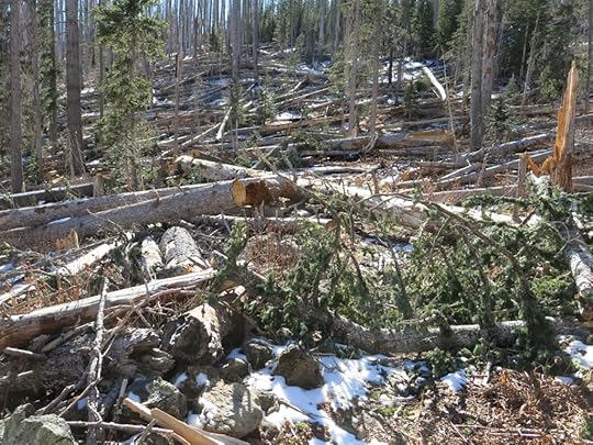
When I first moved here, I discovered right away that the Mogollon Mountains were the tallest nearby range, and there was a five-mile crest trail to the highest peak that looked like a walk in the park, with less than 2,000′ of cumulative elevation gain.
But I lost interest when I read the trip reports of other hikers. The entire distance, including the top of the peak, was densely forested, so there were no views anywhere.
That changed after the 2012 wildfire, because the trail now traversed the heart of the burn area, a “moonscape” in which all vegetation had been destroyed. I figured there might be some decent views up there now. The crest trail starts at a forest road in the far north and runs more than 24 miles one-way to the southernmost high peak, so it has a history of use by backpackers aiming to complete the entire route.
However, the crest trail wasn’t included on the most recent Forest Service maintenance log. And in May of this year, a hiker reported that he was only able to do 3 miles, after dealing with more than 100 deadfall logs across the trail.
So I forgot about it until Sunday morning, when I did another search and found 3 trip reports from August, September, and October. They all claimed the trail had been cleared over the summer. The report in mid-October said the trail was completely clear up to a half-mile north of the peak, where some moderate deadfall began.
Yeah, the drive to the trailhead would take at least two hours, to a place that’s only 30 miles from my house as the crow flies. But I’d done a couple of hikes in Arizona recently that required a two hour drive. It would limit my hiking time, but I’d get an early start and I’m a fast walker.
The final road to the trailhead is legendary – I’d driven the first few miles of it last winter, but the rest of it had been gated – it’s usually closed all winter. It climbs from the old mining ghost town – itself reached by a scary one-lane paved road – over a 9,000′ pass to the high plateau north of our huge wilderness area. I was all stoked to put in another 15-mile day at 10,000′ elevation, with forays onto branch trails, and it didn’t even occur to me until I reached the ghost town that the forest road was almost certainly closed. I wouldn’t even reach the damn trailhead!
My heart sank, but I decided to keep going, knowing there were a couple of earlier trailheads I could take instead, for an alternate hike into lower elevations.
I was a little surprised to find patches of snow on the road through the ghost town – it’s in a deep canyon that remains in shadow through the winter. The storm had hit last Tuesday night, and was limited to the highest mountains – we didn’t even get any clouds in town.
I drove through onto the rough, rocky forest road, and after the first few miles, was surprised to find the gate open. That’s where it gets steep, and I was not even sure my 2wd truck would make it, especially if I hit snow higher up.
But the truck did okay. The road lived up to its legend, climbing up above the world for some truly spectacular views, but the snow was limited to inch-deep, fairly level stretches near the high pass. I passed only one other vehicle, a new-model Subaru with Texas plates parked in a forested, primitive camping area at 9,000′.
A mile or so beyond that was a large, cleared ledge with a Forest Service restroom and an incredible view to the northwest. My trailhead was across the road at the foot of a densely forested slope blanketed with 2″ of snow. It really felt like the top of the world, and the temperature was close to freezing, but the sky was perfectly clear, and since I expected most of the hike to be exposed, I packed my long johns rather than pulling them on.
As soon as I started up the trail, I encountered recent deadfall. Another hiker had recently told me that our local volunteer trail group had tried to clear this end of the trail but had given up because more trees were falling every day, so that was another piece of second-hand info floating around in my mind. I climbed around the first deadfall, but obstacles continued throughout the intact forest that lined the early part of the trail.
After a quarter mile or so, I left the intact forest and entered the burn scar, and the deadfall got really bad. Had all these trees really fallen since mid-October, when the last trip report claimed it fully cleared? It was hard to believe.
I’d recently decided to just accept the obstacles as the new normal, so I persevered. I might not get any decent mileage or elevation, but I’d get a whole-body workout instead. Many logs leaned over the trail at chest-height or higher, and those I could sometimes grab and swing under, with care for the rotator cuff tears in both shoulders. Some could be straddled and rolled over, and some huge logs had a gap underneath that could be crawled through. Others were so broad they had to be climbed over or around, and many involved multiple criss-crossing trunks that required precarious rock-climbing moves with outstretched legs, over a distance of several yards. Of course, a few were simply insurmountable, and I had to find a detour around them.
In a few places I found sections of clear trail that lasted for up to a hundred feet, where I would practically run to make up time. Climbing steadily, the trail traversed from a north slope around to an east-facing slope, and the view east, over country I’d never seen, was welcome. Still, I was hoping to reach a saddle with views to both east and west, and that was slow coming.
As I worked my way hopefully up the long east-slope traverse toward the crest, I encountered more animal tracks in the snow, finally coming upon really fresh mountain lion tracks, maybe from last night or this morning. The lion had been coming down the trail from the opposite direction, and its tracks continued for more than a mile. I envied it the ability to walk under many of the fallen logs that I had to climb over or around.
The obstacles never ended, and although I can hike for hours up much steeper trails without getting fatigued, my whole body was getting worked a lot harder than usual. I wondered how much more of this I could endure.
Finally I reached the crest, a point where the trail crossed over from the east to the west slope. I could now see the interior of the wilderness to the west, the headwaters of the biggest canyon, and the western peak and ridge that I hike regularly, where I’d recently cleared thorny locust with my Dad’s machete. But there was still a maze of charred snags masking my trailside view.
This trail gradually climbed and traversed through more deadfall until I eventually came in view of the highest peak. There was a rocky outcrop where I could climb out above the snags and get an unobstructed panorama of the entire west of the range. What a relief to rise clear of all those dead tree trunks! The peak was close, but it was also clearly covered with snags. There would be no unobstructed view up there! And apparently there was no trail either – it would just be a scramble over fallen logs the whole way up.
I continued to a saddle about a mile short of the peak, and there, at an elevation of almost 10,400′, I met my nemesis. On most of this winding trail, visibility had been limited to a few dozen feet, but facing me ahead was a long, straight uphill section that was a continuous maze of dense deadfall. I’d finally had enough of this, especially since the big peak wasn’t offering the payoff of a decent view.
Reflecting on the multiple recent trip reports that claimed this trail cleared, what amazed me most was that hundreds of snags could’ve fallen on this 4 miles of trail in only a month and a half. I figured I’d dealt with 300-500 fallen trees in all. Yes, we’d had high west winds in November – that’s apparently what had brought them down – but the deadfall was nearly continuous along the whole trail, including forested sections, north, east, south, and west slopes.
After my leg cramp scare last week, I’d been drinking water more regularly, and I’d brought an electrolyte supplement I could add halfway through. I didn’t linger in that saddle because for once, with a two-hour return drive facing me, half of it on that difficult one-lane forest road, I was actually anxious to just get this damn hike over with. And I knew the hike back, battling all that deadfall over again, would really wear me out.
So I took it a little easier on the way down, stopping regularly to try and identify landmarks on the unfamiliar horizon. During the final traverse, a mile or so from the end, I noticed an out-of-place color on the trail ahead. Other hikers, here at the end of the day!
A tall man stood up and waved, an only slightly shorter woman rising behind him. They were carrying medium-sized overnight packs, and appeared to be in their mid-to-late 30s. The woman was beautiful, but the man took over the conversation so I had to keep my attention on him.
They were clearly urban professionals, from San Antonio. I’ve gotten used to most of our visitors being from Texas – New Mexico is paradise for Texans. They’d apparently just driven straight here, and were hoping to spend at least a couple nights out, maybe reaching the end of the 24-mile trail. I knew they wouldn’t make it, and I hadn’t seen any promising campsites in my 4-mile jaunt. They wouldn’t even make it as far as I had, in the time remaining tonight.
I told them the deadfall was bad but didn’t try to discourage them. I was just amazed that anyone would even try backpacking on this trail, in this condition. They’d find out for themselves.
Despite the late hour, it seemed the man could’ve stood there chatting with me forever, but his less enthusiastic companion was getting cold and wanted to keep moving, so he reluctantly bid me farewell and hurried to catch up with her.
I felt sorry for that young couple, forced to clear out a tiny campsite in the maze of charred deadfall somewhere short of the crest, on a night with temps well below freezing. I’ve been there many times myself, you just add to your store of experience. You can imagine my relief when I reached the truck, in plenty of time to enjoy the last light on the peaks and canyon walls, in plenty of time to reach the highway before full dark.
Subtracting stops, it’d taken me 5-1/2 hours to hike that 8 mile round-trip. Compare that with two months ago, when twice as far on clear trail took only a half hour longer. I wouldn’t be exploring this trail again without confirming it was clear!
November 8, 2020
Far From Home
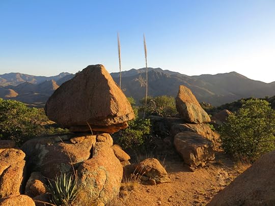
The days were getting cooler. About time – it was the second week of November! Last night we had a high wind advisory, so before leaving for my Sunday hike, I drove into town to check my burned house for fallen limbs. Sure enough, the small elm that leaned over the burned back corner had dropped a limb on my patio.
It had rained a little last night, but the sky had mostly cleared as I drove west. I’d decided to try a new trail, over across the state line, that I’d avoided in the past. I wasn’t sure why. The range was supposed to have the densest black bear population in the country, and this trail went up Bear Canyon. But black bears are shy – I was actually hoping to see one.
It’s hunting season and that area, although far from any town, is popular, so I was also expecting to run into hunters.
The two hour drive passes through some of the loneliest country in the West.
The approach is up a beautiful valley strewn with boulders, between two mountain ranges – the tall one I was hoping to climb, and a lower, drier range that reminds me of my favorite mountains in the Mojave. Golden granite boulders, cliffs, and pinnacles. Balancing rocks. Lots of them.
I wasn’t sure about finding the trailhead, but finding the turnoff was easy. And sure enough, the road to the trailhead was almost completely blocked by a group of hunters with several big trucks and a tent already set up. I waved and carefully passed them onto a badly eroded 4wd track that I pursued for another hundred yards before pulling off and parking.
It took me a while to find the trail – there was no marker, but after one false start, I backtracked and discovered a crude cairn. The trail turned out to be used and maintained primarily by cattle, until it started climbing out of the canyon onto the ridge, where it became a narrow footpath, sometimes hard to follow. I was the first person to use it in a long while.
Aside from the granite, I like the trails on this side of the mountain because they take you from high-desert Sonoran habitat up into mixed conifer forest – and the two ecosystems intermingle in a broad elevational band, in a really interesting way. This side of the mountains shows no evidence of having burned, but the habitat is really complex. I wonder if this is the way all our Southwestern mountains were before wildfire suppression?
It was a big climb – over 4,000′ in 6 miles – and it exposed me to a cold west wind most of the way. Once I reached the crest it was freezing cold, but still mostly sunny. I took a side trip up the little peak which is known for ladybugs in warmer weather, but today was far too cold for them.
The trail continues past the ladybug peak to connect with the scary road that climbs these mountains from the north side. On the way, I got a view north – to Safford, the “city of the plain” – and west, to the highest peaks of the range.
On the way down, I lost my footing in soft dirt trying to bypass a fallen log, and had a bad fall. The wind was brutal and I was starting to get a chill, so I put on all my warm clothing. Then I passed a young guy who was wearing shorts – but unlike me, he was still climbing and generating body heat.
I’d been impressed by the trail going up, but coming back down it seemed a lot rockier and more difficult. Once again, I was fooled by the time change. The sun was setting earlier than I expected.
Near the bottom, I heard footsteps behind me. It was the young guy from the crest. I asked him about his hike, and where he was from – he was from Indiana, like me! He said he’d gone stir crazy, trapped in Indianapolis by COVID, and had decided to take a solo three-week road trip around the west. He was working remotely and hiking as much as possible. He said he just can’t get enough of the West. I sensed that his days in the flatlands of Indiana are numbered. I don’t know how people can stand living in a place with no mountains…
October 26, 2020
Jackpot! A Hike to Remember
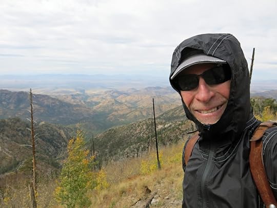
Since last Sunday’s underwhelming hike, my chronically injured foot had become inflamed, and I’d skipped my midweek hike, replaced the metatarsal pad on that orthotic, and conscientiously iced and contrast bathed the foot until it calmed down. And, I’d had a very stressful week trying to finish, for my insurance adjuster, my inventory of “items lost” in the fire – describing in excruciating detail the thousands of priceless things, full of life stories, that had been burned in my basement – things I’d already been reminded of week after week for the past three months.
On Friday, I’d sent off an inventory with glaring omissions, the product of desperation and PTSD, which I then spent additional desperate hours racing to correct. I needed a good hike. But I was still really tired of the hikes near home, so I did a little more research and discovered that a trail over on the Arizona line, that’d been blocked to me last winter, had been cleared by volunteers in September.
I was especially interested in this trail because it led to a different part of the crest of the range, and might allow me to climb the highest peak. After last week’s hike I wasn’t expecting it to be particularly scenic, although the early segment did overlook the 365′ high waterfall – which I was sure would be dry now, after our prolonged drought.
We were due for our first storm of the season on Tuesday, and clouds were already blowing over from the west. The day’s high, at the foot of the mountains, was forecast to each 80, and after last week’s experience with radiant heating at high elevation, I didn’t think I’d need any winter clothing. But I packed my chilly-weather gear as usual, because in the mountains you never know.
One challenge with this trail is that the trailhead lies at the end of a very nasty 1-1/2 mile 4wd road lined with sharp rocks and boulders, constraining my vehicle to a literal crawl. While planning the hike at home, I’d struggled to find ways to extend the distance and elevation to match other recent hikes, and after I’d already driven most of this difficult road, I realized I should’ve just parked at the bottom and walked the road – that would’ve given me the extra distance and elevation I craved. Oh well, next time. It’s just another example of how absent-minded I’ve become since my fire.
After parking at the trailhead and starting up, I glanced back at my vehicle and suddenly noticed a snag – a dead tree – with its top leaning over the left side of my vehicle, held up only by the limb of another tree. The snag itself was rotten and its trunk sagged. What were the chances it would fall on my vehicle while I was hiking? Based on the position, I was pretty sure it would just cause cosmetic damage. Due to the slow drive, I was already getting a late start. I decided to trust the universe, although I know a certain risk-averse friend who will chastise me yet again for taking unnecessary risks.
At 10:30am the morning was chilly but partly sunny and calm as I worked my way up the long, shallow canyon toward the switchbacks that led to the falls overlook. I had my shirt buttoned up, but didn’t need a sweater or jacket. When I reached the overlook, I noticed a little trail that led out along a narrow ridge, and discovered something I’d missed on my first visit. If you held onto the branches of shrubs, you could scramble out onto the edge of a cliff and get a full frontal view of the falls. I was surprised to see a trickle of water still running over the falls, and the foliage around it was amazing! I couldn’t figure out what those red trees were – I didn’t see them anywhere else.
From the overlook, the main trail switchbacks steeply up to the mouth of a “hanging” canyon, where I’d been stopped last winter by a big blowdown of living pines. The crew had cleared them all, and I made my way quickly up the canyon, along a trail that dips toward the creek in the bottom, which was still running. Golden aspen saplings carpeted the opposite slope above.
I had a vague notion that the trail would cross the creek, but instead, it entered a narrow, rocky gulch and followed the creek for quite a distance. It was one of the prettiest places I’d yet seen in these mountains, singing with the sound of water and painted with a riot of fall color. Maybe I’d underestimated this trail!
Finally the trail climbed above the creek, and after a few more gentle switchbacks I spotted the cabin ahead through the trees. I knew there was a cabin, used by trail crews and locked, but I had no idea it’d be so pretty. It’s always a shock to see a house way up in the mountains, miles from any road.
From there, it was a short walk to the saddle where this trail ended in its junction with the main crest trail. But just before I reached the saddle, I began to hear a roaring like a freight train. I looked up, and saw the tops of tall pines bending in a gale force wind. I walked directly from calm air in the canyon to a hurricane on the saddle, and it was easy to see why. I’d crossed the watershed, and now had a view more than a hundred miles to the west, with nothing to stop that west wind.
I dropped my pack and hauled out my sweater, windbreaker, and knit cap, and packed away my straw shade hat. The cloud cover was nearly complete, air temperature was probably in the 50s, and wind chill brutal, but I was now plenty warm. From here, the crest trail led south toward the peak of the range, traversing a steep slope whose forest had been completely burned off. In fact, most of the slopes I could see had been cleared by the 2011 wildfire, but like all burn scars in these Southwestern mountains, they were being patchily colonized by ferns, oaks, and aspens, so the old carpet of green was now a coat of many colors. And the lack of forest meant that I had a truly spectacular view west for the entire distance of the traverse, out over a long canyon to a broad plain and many far blue ranges I couldn’t identify.
The wind continued throughout the traverse – it was like being a fly on a wall, bearing the full brunt – but I love all kinds of weather and this was exhilarating at the end of an unusually hot, dry October. One of my favorite things in the world is to walk along a ridge with endless views across the landscape below. It’s a luxury that comes at the cost of the effort of climbing up there – it’s the payoff.
I’d been seeing fresh boot tracks – the ubiquitous Merrell Moabs – in the dirt of the crest trail, and halfway along the traverse, I passed a college-age couple returning, dressed in shorts and short-sleeved shirts – ah, the optimism of youth! They seemed to be having a great time, though. I hadn’t seen their tracks on the lower trail, so I figured they’d started from the crest trailhead, farther north, which is reached by a very long forest road and eliminates the need for a climb.
The next saddle, at the base of the peak, was aglow with fall color and offered three choices of trail. I’d planned to hike the peak, and since the trail guide showed the peak trail continuing down the back side, I figured I’d use that to add distance, looping around on a lower trail to return to the saddle and gain some more elevation.
In general, trails in this range are much better maintained than our trails near home, but the short trail to the peak was almost shockingly good. To my frustration, forest on top was intact, so there were no views, and after exploring a few hundred yards, I couldn’t find the extension of the trail down the back side. So I had to return the way I’d come.
Back at the junction, I took the western fork, which I believed dropped a few hundred feet to another junction saddle behind the peak. It turned out to be mostly forested, but with enough breaks to keep the western view in sight. It was quite rocky and really a beautiful stretch of trail, adding over a mile one-way to my hike. Despite the cloud cover, the colors of isolated trees and patches of foliage seemed to be intensifying as the sun sank lower in the southwest. I was realizing this was by far the best hike I’d found in this range – finally!
The hour was getting late and it was time to head back the way I’d come. I was really craving a red chile pork burrito at the cafe at the entrance to the mountains – it’d been so long since I’d had good Mexican food! But they close at 6, and it was almost 3, and I had a 6 or 7 mile hike back down to the trailhead. And from there, that mile and a half of road from hell – which took at least 15 minutes. And after that, the long dirt road down the main canyon, with its 15mph speed limit and blind curves hiding oblivious birders.
But the biggest obstacle to my burrito was COVID. According to the guidelines, if I interacted with anyone here, I’d need to self-quarantine and get tested back home. All that for a burrito? I was sorely tempted, because I live alone, have no social life anyway, and no pressing plans to go out while at home. Hell, I’d probably even get a room at the Lodge, since otherwise I’d be driving home in the dark, tired and sleepy after that burrito.
All the way back along the howling traverse with its glorious western vista. And finally to the first saddle, with its apocalyptic gale. A few yards down the trail past the saddle, I stepped out of the wind, and the freight train sound fell away. The temperature increased about 20 degrees and I packed away my outerwear and strapped on my knee brace for the long descent.
Approaching the cabin, I flushed a hawk out of the lower branches, but it stopped on a snag nearby and ignored me.
My vulnerable foot doesn’t like to be rushed. But in the end, it was the beauty of this place that slowed me down the most. Once I was in the canyon bottom, the streamside foliage stopped me again and again.
At the falls overlook, I had to clamber out on that cliff again, because the light had been bad for pictures in the morning. And the farther I went down the trail, the more wonder I found in little things.
By the time I got to the vehicle, it was 5:45. No way was I going to get that burrito. It took me 20 minutes to drive the 1-1/2 mile 4wd road. It was 6:30 by the time I reached the cafe. I tried the door but it was locked. There was nothing for it but to drive the two hours home in the dark and warm up some leftovers.
It was worth it.
October 5, 2020
Autumn Leaves
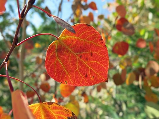
While dealing with the aftermath of my house fire, I was only able to do one hike per week, and I was sure I would lose conditioning and capacity. Hence after I got settled into temporary housing, I was really stoked to resume the routine I’d built up to over the past two years: three hikes a week averaging 22 miles and 6,000′ cumulative elevation gain.
But after the first week it was clear that I hadn’t actually lost any capacity. And between hikes, it gradually occurred to me that I’d been paying for all that hiking with a lot of inflammation and pain, and the time I was spending icing my joints afterward. So I decided to cut back and drop one of my 5-mile midweek hikes.
The Sunday after that decision, I was still overwhelmed with chores and I didn’t feel like driving to one of my favorite trails in the high country, so I picked a hike close to town that involved chaining together three trails and two 9,000′ peaks. It would be a long hike that I’d never actually completed before. The part I’d done, to the first peak, was 12 miles round trip, and I had it in my head that adding the second peak would increase it to 14 miles. I’d regularly been doing 13 mile hikes, so I didn’t see any problems.
The hike starts by climbing gently for two miles up a beautiful canyon, then it enters mixed conifer forest, and it stays in forest, climbing steadily, the rest of the way. It has few views and no prominent features, but the forest is really nice and the trail is easy most of the way because the forest hasn’t burned recently.
However, somewhere between the two peaks, I realized I’d underestimated. The round trip mileage was going to be 16, not 14. My body was going to be thrashed. Should I turn back early?
I was feeling good, so I went the whole distance – the longest hike I’ve done in 30 years. I rested for a half hour on the picnic table below the vacant fire lookout, and as I was packing to return, a bearded guy about my age appeared from the opposite direction, having hiked the much shorter trail I used to do on Sundays. He sat down nearby and had a snack, and eventually asked me where I was headed.
“Back the way I came,” I said. “Do you know the trails around here?”
“Well, sort of.”
“I came up Little Cherry Creek, do you know that?”
“No.”
“It’s in a dip before you get to the Ben Lilly site. I take that to the CDT, to Black Peak, and then the spur trail from there. It’s about 8 miles one-way.”
“Well, the trail I hiked is really hard,” he said disgustedly.
“Yeah, I used to do that trail almost every week, before I started needing more distance.” I realized I was making him look pretty bad, so I added, “It’s a great trail, though, if you don’t have time for a longer hike.”
He looked away unhappily. I wished him a good day and set off on my 8-mile return hike.
As expected, I paid for it at the end, limping back to the car on a sore foot and a sore knee. But amazingly, since the trail was in such good shape, it only took me 6-1/2 hours to do 16 miles.
A pile of chores hit me during the following week, so I had no time for icing, and I skipped my midweek hike, figuring I’d done enough hiking for the week.
On the following Sunday, I set out for my favorite high-elevation hike, an hour’s drive west of town. My foot and knee felt fine at that point, and I was even more excited than usual about hitting the trail.
I was a little surprised to find the trailhead occupied, with a family all decked out in identical camouflage outfits milling around their SUV. As I got out, I yelled, “You guys going hunting?”
The father came over, wearing a midsize pack with a rifle pointing out of the top. He looked to be in his early 40’s, tall and strikingly handsome, and when he spoke, he immediately reminded me of the charismatic, good-looking Jewish intellectuals from the East Coast that had so intimidated me during my university years at the University of Chicago and Stanford. But he said they were from Cliff, the rural community that’s ground zero for the Cowboys for Trump movement!
He was super friendly, saying his son had a bear tag and they were headed for the “top” to glass for bear. “Holt Mountain?” I asked.
“Oh, no, we’re not going very far, just to where we can get a good view.”
“The Johnson Cabin trail?”
“I don’t know, where are you headed?”
“Holt Mountain, that’s why I asked.”
“No, no, we won’t be anywhere near you.”
I was left with lots of questions, but had no business prying. His kids looked to be no older than 10 – do they really issue bear tags to kids that young? And what was this suave, urbane guy doing in Cliff, and hunting predators, a practice I normally associate with arrogant assholes?
I always come prepared to hit the trail immediately after arriving, but as a family it was taking them forever to get ready, so I left them there and headed out.
Already, during the first half mile, everything felt very different. It was a cool fall day with clear skies, so that was nice, but my body felt better than ever. It felt like I’d developed hiking super powers. This is a long, hard trail with steep grades beginning about halfway, but I powered up every one of them without needing to rest. What had happened? I’d been hiking less during the past two months than at any time in the past two years, but here I was in better shape than ever.
Not needing to stop to catch my breath, I reached the little clearing at the bottom of the switchbacks almost an hour earlier than usual. I wasn’t conscious of hiking faster than usual, but obviously I was.
Then, on the long, steep traverse that is always the hardest part, I just walked steadily up it for the first time, whereas in the past, I’d always had to stop 3 or 4 times to catch my breath.
I reached the crest at 9,500′ an hour and a half ahead of time. During the past week, a friend from Santa Fe had said that his family was planning a hike to see aspens in their fall colors, and as I rounded a shoulder of this peak and saw the saddle up ahead, I realized that since I hike in aspens almost every week, their fall color isn’t all I get to see. Most busy city people only venture into nature to witness popular spectacles they discover through news media, like “superblooms” and “supermoons,” whereas I get to discover dozens of equally interesting and beautiful, but lesser known, seasonal phenomena all throughout the year.
The little grove of aspens in the saddle was blazing red and gold, but they were all small trees because they were part of early succession after the massive 2012 wildfire in these mountains. From up there, I could see bands of color striating distant peaks – all of them small trees in dense fire-recovery stands. Nothing like the towering, mature groves we used to admire in the High Sierra of California. In fact, since I moved to New Mexico and began hiking wildfire scars, I’ve come to see aspens not as beautiful members of mature forests, but as scrubby thickets colonizing burn areas. On these slopes, they alternated with the deeper red of maples as well as rust-colored oaks and ferns. The brown of the ferns actually covers the broadest expanse of these fire scars, and is attractive in its own right.
But it wasn’t just trees. From the beginning of my hike, deep in the canyon bottom, I’d been surrounded by fall color: flaming sumacs, golden oaks, burgundy poison ivy, rust-colored ferns, and a myriad of shrubs and tiny ground cover plants that created a mosaic of color, making even the predominant green seem more vibrant.
Since I’d reached the crest so early, and still felt so good, I hiked down the other side, planning to go much farther than usual. This trail already offers the most elevation gain of any, so I was really stoked. It actually continues all the way to the crest trail of the central range, for a total of 19 miles one-way – the rest of the trail is only used by backpackers. I was curious to see how far I would get, especially since the rest of the trail is choked with fallen logs and thorn scrub, including the nasty New Mexico locust.
It got harder and harder the farther I went, and only my new hiking super powers kept me going. The trail actually got more interesting, too, with more exposed rock and new views, but eventually I realized I’d better turn back if I wanted to get home before dark. Taking off my pack to log my position via GPS, I noticed the bandana I’d tied on to dry had been dragged off somewhere by thorns. It’s a nice one printed with the constellations so I hated to lose it, but on my return, I found it on the trail, back near the crest saddle.
White-tailed deer were everywhere, and red-tailed hawks soared through the tall firs and wheeled around summits. The hunting dad had mentioned a fire over in the Blue Range primitive area, to the northwest, and after returning to my vehicle and driving down out of the foothills, I could see the long plume and then a billowing cloud rising above the tallest peak of the range, dozens of miles away. When will this fire season ever end?
September 21, 2020
Burned Ridge
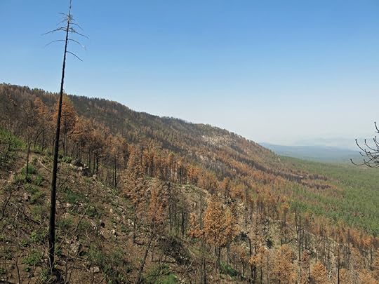
I first started hiking the six-mile-long ridge north of town ten or twelve years ago, but only the first couple of miles – I wasn’t doing longer hikes back then. It was never one of my favorite hikes; there were higher peaks closer to town, there wasn’t much exposed rock, and the rare views through the forest up there merely showed more forested hills.
But during the past two years, as I started challenging myself, measuring and logging distance and elevation, I wondered what it would be like to hike the entire ridge. Maps showed something called a “lake” at the west end of the ridge, near the top, more than six miles from the trailhead on the highway. That made no sense – lakes don’t form near the tops of ridges, in this latitude, at that elevation, in the arid Southwest.
But the “lake” gave me a mystery to explore, and on contour maps I could see that the trail had enough ups and downs to give me a significant overall elevation gain, so in December 2018, I tried to hike the distance. I was just starting to build capacity and only made a little over five miles, frustratingly close, before I ran out of time, only five days from the shortest day of the year, and had to turn back.
Five months later I finally made it. The “lake” turned out to be a turbid stock pond excavated out of a small forested plateau and filled naturally by annual precipitation, permanently muddy due to electrically charged particles of clay in suspension. It didn’t invite you to take a dip, but it was sufficiently incongruous, up there in the Southwestern sky, that it made the fairly grueling, twelve-plus-mile roundtrip ridge hike worthwhile.
Like with all my repeated hikes, I came to know it in sections. The initial ascent up and across the eastern shoulders, past a broad exposure of unusual white rock to an old burn scar, colonized by dense ferns, that offered a view east toward the “moonscape” of a more recent wildfire around the peak of the range. The meandering traverse of the steep north slope, shaded and densely forested with fir, which always seemed damp no matter how dry the season was. The punishing climb to the high point of the ridge, actually a narrow, rocky, mile-long “plateau” of parklike pine forest. Then began a rollercoaster of steep ups and downs, in which pine forest alternated with rocky sections of agave and mountain mahogany, that lasted another couple of miles and ended at the pond.
I hiked it again in April of this year. Then in June, I was rushed to the hospital with severe back pain, and a few days later, lightning started a wildfire in one of the little canyons below the ridge. I first saw the smoke from a hill in town, a few blocks up my street. The fire quickly climbed to the ridge, and strangely, as far as I could tell from the wildfire website, spread east along the opposite slope, probably a trick of the wind. I was pretty dismayed, on top of the pain I was feeling. What would happen to this familiar habitat near home?
The fire jumped to the east end of the ridge, where the trail begins, and they closed the highway. It turned out to be closed for the next month, as firefighters surrounded the fire and barely kept it from crossing the road, where it would’ve had miles of unbroken forest fuel dotted with occupied cabins. The perimeter was still pretty big, and the fire kept running out onto secondary ridges. When I was able to hike again, I targeted peaks that would give me a closer view.
Finally they reopened the highway and I drove around the eastern edge of the fire. All access to the ridge was off limits, and helicopters were still filling up at roadside “pumpkins” and sailing off to make drops in remote drainages. Several miles past the ridge, I found a barely passable back road and eventually got a limited view. The entire north slope of the ridge, which was where the trail mostly traversed, seemed devastated. Based on recent experience, I doubted the trail would be usable any time soon. And that dense, humid forest, with its ferns, mosses, and wildflowers. Gone for decades, maybe forever.
Since my house fire, I’ve been driving at least an hour away for my Sunday hikes, but his weekend I just didn’t feel like driving. In addition to the burned ridge hike, there was another nearby possibility that I decided on. But since it was only about ten minutes farther to the ridge trailhead, I figured I would check on the slim chance that the trail might be open. I didn’t expect it to be clear of fallen trees or erosion from monsoon rains, but I’d take a quick look before returning to hike the other trail.
I was surprised to see nothing but the usual post-fire warnings at the trailhead. I was so curious to see conditions up the trail, I hoisted my pack and set out.
At mid-morning it was cool, in the low 60s, with a forecast high in the low 70s – a perfect fall day for hiking. I knew from my earlier drive that the forest on this first section had burned patchily, with roughly half the trees killed. But they were still standing, and the trail was as clear as ever. The gentle slope at the beginning was gold with pine needles, but they were all needles that had been killed by the fire and were continuing to drop from limbs above.
As I climbed toward the shoulders of the ridge, I found logs that had been recently cut, and clear tread on the trail. I realized that during “mopup,” firefighters had used this trail to monitor the fire, hence they’d had to keep the trail open. I hadn’t thought of that, and it made me hopeful about the rest of the hike.
As usual, I was hoping to be the first, or one of the first, to hike this trail since the big event. There were only two human footprints preceding me since the last rain, a couple weeks ago: a big man and a small woman. In the first couple of miles, destruction was patchy. I was impressed to see trees whose vegetation had been killed almost to the top, but still retained a small crown of green. The slope of ferns had been completely burned off, but smaller ferns had sprouted over much of it.
There was a lot of green, but it was mostly new growth since the fire – annual wildflowers and thickets of fast-growing thorny locust. It wasn’t until two miles in that I hit a badly burned section of north slope. Whereas before, the trees still bore their dead needles or leaves, here they were only black skeletons. Every now and then I came upon a tree that had burned down to nearly nothing, or the empty tunnels left in the ground when even the roots of the tree are consumed. The soil had been burned off the steep slopes and loose sediment was washing downhill, cutting away sections of trail. I stubbed my toes, slipped, and stumbled over and over again, and fell a couple of times.
My favorite tree on this hike was the one on the high plateau that had lost its trunk and grown a new trunk from a lateral branch. I was afraid it’d burned, but on reaching the top I found it safe, only sixty feet from the edge of destruction. The ridgetop was like that in many places – a sharp line between total destruction and intact habitat.
Looking at slopes from a distance, I could see that the fire had made linear “runs” like long fingers of black up and down steep slopes. Thinking of the chemical and physical phenomena of fire it always seems strange to think of it as an active “thing” – something seemingly alive that can move across the landscape with a will of its own – whereas a physicist or chemist would view it as a series of discrete microscopic and macroscopic events and interactions between forces, particles, living and dead organic tissue, cells and structures. The fire is just the visible, tactile sensation of what’s going on invisibly. How can it be something big and continuous that moves across a landscape? But it does.
I found myself focusing in on the details – the varying effects of fire on different plants. The core blades of agaves mostly survived while the outer ring burned. Many trees seemed completely dead until you noticed a few surviving branchlets at the very top. I realized this had uniformly been a ground fire rather than a crown fire. In many places, the duff and organic matter in the soil had burned but the bark of the pines had barely been singed. In other places, slopes where the dominant vegetation had been mountain mahogany, everything was charred and skeletal and even the rocks were blackened.
There was much less shade after the fire, and I was surprised that it felt like the 80s up on the ridge top – far from the cool fall day I’d expected.
The footprints of the big man and the small woman ended on the high part of the ridge, less than four miles in. The well-maintained trail ended there, too – apparently even firefighters hadn’t gone any farther. But I knew the trail well even if it was invisible to others.
Eventually, moving in and out of burn scars and intact habitat, but always with evidence of spot fires that consumed isolated trees in the midst of green, I reached the plateau and the pond. The parklike forest around it was mostly intact. The water level was down, and individual small trees had burned right up to the edge.
I found a pistol, apparently left by a hunter, and a motion-sensor camera someone had set up on a tree trunk. The other access to this place is via a short hike up from a remote forest road – a lot more driving, a lot less walking.
I was sore all over, and the hike back was a real slog. But considering that I’d been hiking and working out much less during the past month, I felt in pretty good condition. Apparently I can take it easier in the future and still stay in shape.
I took the pistol back with me. I’ve used a fair variety of guns, ever since childhood, but this was a new model with a plastic stock. I couldn’t figure it out and even thought it might be an air gun at first. It was holstered, and I stashed it in my pack. At home I looked it up and found that it’s an expensive sidearm, highly rated for both target shooting and personal defense. I took it to the sheriff’s office the next morning. They seemed pretty freaked out, detaining me and checking my ID in the system while a senior deputy took the gun outside to check it for ammo. Then they let me go without any further fuss, after taking my cell number in case the owner was offering a reward.
I also found online that one other person had logged a hike on the ridge trail after the fire – ironically, the day before me – but he’d only gone four miles. The big male footprints were explained, and I kept my distinction of first to complete the trail since the fire.


