Rick Just's Blog
August 23, 2025
SMOKE GETS IN YOUR EYES: Fire Lookouts in Idaho
Editor's note: I'll post new stories on my Facebook page once or twice a month. If you'd like to get a new story every week, along with a lot of other content, click Subscribe at the top right of this page.
Bertha Hill, 30 miles northeast of Orofino, was named by some college boys working for the Clearwater Timber Protective Association. The rounded mountain reminded them of a girl they knew in Moscow in the way the Tetons reminded French trappers of women they knew.
The hill might better be named Mable Mountain and not for a sophomoric anatomical joke. Mable Gray spent many hours on that mountain in 1902, sitting on a tree limb looking for smoke. For her vigilance, Gray is remembered as the first fire lookout working strictly to protect a forest in the Western states.
Mable Gray's days started early, with her making breakfast for the timber camp and cleaning up the dishes. If thunderstorms had rolled in overnight, Mable cleaned up quickly, hopped on a pony, and rode to the top of Bertha Mountain. It wasn't enough for her just to stand there gazing out over the million-acre Clearwater-Potlatch private forest looking for smoke. She'd tie up her horse and climb a crude ladder—two rough-cut poles with severed limbs nailed on them—to the beckoning branch of a hemlock snag 12 or 15 feet up. She sat in a makeshift seat on that limb for hours, protecting the company's investment. If she spotted smoke, Mable scrambled down the ladder and back onto the horse to alert the crew to the fire.
 Mable Gray got a little help the first time she climbed the snag where she perched on top of Bertha Hill. Courtesy of the University of Idaho Potlatch Lumber Company Digital Collection.
 Mable's perch in that tree is long gone today, but there's a fire lookout on Bertha Mountain, one of about 177 still operated in Idaho today. Close to a thousand lookouts have dotted the state since that first crude perch. Most were eventually abandoned, aerial and satellite imagery largely taking the place of on-the-ground spotters.
The Forest Service, founded in 1905, saw the wisdom of fire spotters early on. If a crew could reach a fire while it was still small, they stood a better chance of putting it out. The Forest Service unofficial firefighting motto became "Spot Em Quick, and hit Em Fast."
Just spotting a fire wasn't enough. A spotter needed to provide an accurate location to send crews. So William Osborne, a Forest Service employee, invented the Osborne Firefinder in 1915. It's a circular table overlaid with a topographic map of the area fitted with moveable sights an operator looks through to pinpoint smoke. A spotter lines up the sights to get a horizontal reading in degrees and minutes and uses an attached tape to estimate the miles between the smoke and the lookout. You couldn't use a sophisticated instrument like that while sitting in the crook of a tree as Mable Gray did. Lookout towers grew more complex and substantial as years went by.
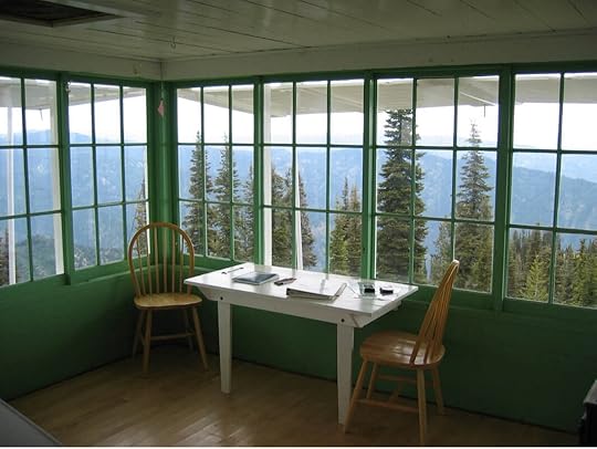 The view from inside the Deadwood Lookout near Garden Valley.
  There’s no need for a tower at the Deadwood Lookout near Garden Valley.
In 1929 the Forest Service began using a design called the L-2, first implemented on Lookout Mountain above Priest Lake's Cavanaugh Bay. The standardized model was a 12-by-14-foot building complete with framed glass. There was a sleeping and living area on the first floor. The spotter who worked in a lookout did their fire spotting from a cupola above. These structures cost only $500 to build. The L-2s started popping up on mountains and on metal towers all over the West. Some 5,000 lookouts of various designs were active in their day.
Spending days alone in a tall, windowed contraption with a 360-degree view of nature seems like a dream job for writers. So thought Gary Snyder, Jack Kerouac, Norman Maclean, and Edward Abbey, all of whom served as fire spotters.
If a bit of solitude appeals to the writer in you, check with the Forest Service to find out what spotter jobs are available. Or try it for a weekend. You can rent some old lookouts in Idaho. Stay in the tower at the self-referential Lookout Butte Lookout near Riggins for $40 a night. If mountaintops appeal to you, but you'd rather not perch on those spindly legs, try the Deadwood Lookout recreational cabin near Garden Valley, built by the Civilian Conservation Corps in 1934. That will run you about $55 a night. Release your inner Mable Gray and find a rental at recreation.gov.
 The Blue Point Lookout Station on Rice Peak in the Payette National Forest, near Cascade. The photo was taken in 1920. Courtesy of the University of Idaho Potlatch Lumber Company Digital Collection.

August 4, 2025
Blackfoot River Petroglyphs
Editor's note: I'll post new stories on my Facebook page once or twice a month. If you'd like to get a new story every week, along with a lot of other content, click Subscribe at the top right of this page.
Grab a cup of something. This is a long one.
I grew up along the Blackfoot River in Eastern Idaho, not far from the town of Blackfoot. Given the name of the river and town, one might think Blackfeet Indians played a key role in the history of the area. They did not.
Shoshone or Bannock Indians left behind the “Indian writing” a couple of miles from our house, which I grew up hearing about. The river leaves the deep canyon it cut and meanders along for a few miles between the mountains on the south and Presto Bench on the north. That secluded valley was a wintering spot for the tribes and, in 1870, a homesteading spot for the Just family.
I explored the lava rocks on which someone had drawn strange symbols centuries before, many times in the summers of my youth. Along the upper edge of the cliffs, you could see redoubts, rocks piled to hide behind and imagine what native men were hiding from.
I heard only vague stories about the possible meaning of the rock writing. One was that scientists from the Smithsonian had come to document the petroglyphs in the 1920s.
That story, as it turns out, was a bit inflated. John E. Rees studied the petroglyphs along the river in 1926. He sent that study to the Smithsonian.
Rees was an attorney, a high school teacher, a state senator, a “professor,” and a fanatic about history, especially as it pertained to Indians. He wrote several papers digging deeply into indigenous languages, pulling definitions together in defensible, if tortured, ways to explain the etymology of place names in the West. Perhaps his most famous explanation was how Idaho got its name, attributing it to the Shoshone words “eh” (coming down), “dah” (sun, root, or mountain), and “how” (the equivalent of an exclamation mark).
The Rees interpretation was widely accepted for years, but research by Idaho’s most esteemed historian, Dr. Merle Wells, proved it wrong in about 1958 (see story below).
It was that same John Rees who visited “my” rocks along the Blackfoot River in 1926 and attempted an interpretation of the petroglyphs based on his conversations with a Shoshone tribal member who was an artist.
There are many rocks with rock art on them on my cousin’s property in the valley where I grew up. They may have once been close to the river. If so, the river has meandered about a half mile to the south since then. But it was one rock in particular that made the news in 1926.
The Idaho Statesman, displaying little sensitivity to ethnic slurs at the time, led off with this boxed headline: “John E. Rees, Authority on Folk Lore of the Redskins, Explains Picture Writing Found on Rock on Bank of Blackfoot River.”
Susie Trego, the wife of Blackfoot’s Idaho Republican newspaper publisher, was credited with “finding” the rock. Doubtful. It’s more likely my great aunt, Agnes Just Reid, showed it to her. Reid was a long-time columnist for Blackfoot papers and a friend of the Tregos. She lived near the rock for all of her 90 years.
Trego claimed the 875-pound rock and moved it to her mansion in Blackfoot, Sagehurst. Thanks to the efforts of my cousin, Marlene Stibal Reid, it would be returned to the Blackfoot River Valley 69 years later. Someone blew the math in the photo caption below. But I digress. You need to know what was scratched onto the rock. It was, after all, “the story of one of the first great peace conferences ever held on the American continent,” according to the Idaho Statesman. According to “Professor” John Rees.
The title Rees often used is in quotes because he was never a college professor and did not have a degree in history, as one might assume. “Professor” was a fairly common colloquial title of respect in the early part of the Twentieth Century. He taught history and science in Salmon and was well-respected by historians at the time.
Rees also ran the Indian trading post at the Lemhi Agency near Salmon for 17 years. There he vigorously studied native languages and the symbols of petroglyphs—images carved into the surface of a rock—and pictographs—images painted on a rock with natural pigments.
The remarkable rock “borrowed” by Susie Trego told a story. John Rees retold it in excruciating detail using the photo below and describing each symbol by its corresponding number.
 In the Rees interpretation, the rock was an invitation to a meeting to divide hunting rights between tribes in what is now Idaho and Wyoming. Those stumbling upon the rock were to pass along the complicated message so the chiefs could meet, according to Rees.
There are some holes in the interpretation. First, why bother spending hours scratching this on a rock in the first place when you could simply assign a runner to get the word from one tribe to another? Second, although there was some commonality in the symbols, their interpretation probably wouldn’t survive precisely for a thousand years in a game of “telephone” passed through the centuries. Third, what good was an invitation without some way of knowing what date, or year, or even season, the invitation was for?
To give you a taste of a Rees explanation of rock writing without making you slog through pages, I include a few lines from a description of the following plate depicting symbols at the Blackfoot River site. It appeared initially in the 1923-24 Biennial Report of the Idaho State Historical Society.
 “Fig. 1, represents the 'rising sun,' so denoted by the rays shooting from it. To an Indian every object in nature is endowed with a spirit, the source of which is the sun. His own spirit coming from a spirit eventually will return to it. This orb, then, is the sun, father of the Indians. The sun-father made two brothers, the wolf and the coyote, who lived in a cave near a spring that came from solid rock. The coyote went to live with a fair young girl and from their union came the Shoshonis and Bannacks. This is the 'coyote cult, and is represented in Fig. 2.”
The air of authority in the writing of John Rees and the certainty he exhibits is what originally cast doubt on his work for me. Archaeologists today are hesitant to assign meaning to such symbols.
I wouldn’t argue that the first figure might be the sun and the second a coyote. As the figures become more abstract and less representational, my confidence in the Rees interpretations wanes.
Even so, I have a favorite. I’ve always been drawn to the coyote because of its simple, nearly Picasso-esque lines. One line, the tiny one emanating from the creature’s mouth, has always fascinated me. It’s clearly (yes, I’m making the same leap as Rees often does) barking or howling.
A “sound line” such as that is common in cartoons today. The technical term for it is emanata. I was surprised and delighted to see it in ancient artwork.
I’m grateful to John Rees for recording the rock art from my home valley for posterity, even though he was complicit in moving the “gathering stone” from its original site. But, I do have one more complaint that I must pass on. Rees went over the rock art with some kind of whitewash for the purpose of making the art stand out in photographs. Another method often used is to go over the lines with chalk. This was a common practice in his day, so I can’t much fault Rees for it, but I must point out that archeologists today vehemently discourage that. It can degrade the petroglyphs and pictographs. It also captures only what the photographer saw, and not what might actually be there on closer examination.
And with that, I’ll quit picking on Mr. Rees, who, despite his over-eager interpretation, is guilty mostly of trying to understand the world around him. We’re all guilty of that.
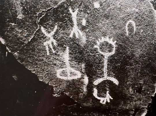 One of the photos John Rees took of the Blackfoot River rock art. Not that the art has been “chalked.” What story do you think it tells?
Grab a cup of something. This is a long one.
I grew up along the Blackfoot River in Eastern Idaho, not far from the town of Blackfoot. Given the name of the river and town, one might think Blackfeet Indians played a key role in the history of the area. They did not.
Shoshone or Bannock Indians left behind the “Indian writing” a couple of miles from our house, which I grew up hearing about. The river leaves the deep canyon it cut and meanders along for a few miles between the mountains on the south and Presto Bench on the north. That secluded valley was a wintering spot for the tribes and, in 1870, a homesteading spot for the Just family.
I explored the lava rocks on which someone had drawn strange symbols centuries before, many times in the summers of my youth. Along the upper edge of the cliffs, you could see redoubts, rocks piled to hide behind and imagine what native men were hiding from.
I heard only vague stories about the possible meaning of the rock writing. One was that scientists from the Smithsonian had come to document the petroglyphs in the 1920s.
That story, as it turns out, was a bit inflated. John E. Rees studied the petroglyphs along the river in 1926. He sent that study to the Smithsonian.
Rees was an attorney, a high school teacher, a state senator, a “professor,” and a fanatic about history, especially as it pertained to Indians. He wrote several papers digging deeply into indigenous languages, pulling definitions together in defensible, if tortured, ways to explain the etymology of place names in the West. Perhaps his most famous explanation was how Idaho got its name, attributing it to the Shoshone words “eh” (coming down), “dah” (sun, root, or mountain), and “how” (the equivalent of an exclamation mark).
The Rees interpretation was widely accepted for years, but research by Idaho’s most esteemed historian, Dr. Merle Wells, proved it wrong in about 1958 (see story below).
It was that same John Rees who visited “my” rocks along the Blackfoot River in 1926 and attempted an interpretation of the petroglyphs based on his conversations with a Shoshone tribal member who was an artist.
There are many rocks with rock art on them on my cousin’s property in the valley where I grew up. They may have once been close to the river. If so, the river has meandered about a half mile to the south since then. But it was one rock in particular that made the news in 1926.
The Idaho Statesman, displaying little sensitivity to ethnic slurs at the time, led off with this boxed headline: “John E. Rees, Authority on Folk Lore of the Redskins, Explains Picture Writing Found on Rock on Bank of Blackfoot River.”
Susie Trego, the wife of Blackfoot’s Idaho Republican newspaper publisher, was credited with “finding” the rock. Doubtful. It’s more likely my great aunt, Agnes Just Reid, showed it to her. Reid was a long-time columnist for Blackfoot papers and a friend of the Tregos. She lived near the rock for all of her 90 years.
Trego claimed the 875-pound rock and moved it to her mansion in Blackfoot, Sagehurst. Thanks to the efforts of my cousin, Marlene Stibal Reid, it would be returned to the Blackfoot River Valley 69 years later. Someone blew the math in the photo caption below.
But I digress. You need to know what was scratched onto the rock. It was, after all, “the story of one of the first great peace conferences ever held on the American continent,” according to the Idaho Statesman. According to “Professor” John Rees.The title Rees often used is in quotes because he was never a college professor and did not have a degree in history, as one might assume. “Professor” was a fairly common colloquial title of respect in the early part of the Twentieth Century. He taught history and science in Salmon and was well-respected by historians at the time.
Rees also ran the Indian trading post at the Lemhi Agency near Salmon for 17 years. There he vigorously studied native languages and the symbols of petroglyphs—images carved into the surface of a rock—and pictographs—images painted on a rock with natural pigments.
The remarkable rock “borrowed” by Susie Trego told a story. John Rees retold it in excruciating detail using the photo below and describing each symbol by its corresponding number.
In the Rees interpretation, the rock was an invitation to a meeting to divide hunting rights between tribes in what is now Idaho and Wyoming. Those stumbling upon the rock were to pass along the complicated message so the chiefs could meet, according to Rees.There are some holes in the interpretation. First, why bother spending hours scratching this on a rock in the first place when you could simply assign a runner to get the word from one tribe to another? Second, although there was some commonality in the symbols, their interpretation probably wouldn’t survive precisely for a thousand years in a game of “telephone” passed through the centuries. Third, what good was an invitation without some way of knowing what date, or year, or even season, the invitation was for?
To give you a taste of a Rees explanation of rock writing without making you slog through pages, I include a few lines from a description of the following plate depicting symbols at the Blackfoot River site. It appeared initially in the 1923-24 Biennial Report of the Idaho State Historical Society.
“Fig. 1, represents the 'rising sun,' so denoted by the rays shooting from it. To an Indian every object in nature is endowed with a spirit, the source of which is the sun. His own spirit coming from a spirit eventually will return to it. This orb, then, is the sun, father of the Indians. The sun-father made two brothers, the wolf and the coyote, who lived in a cave near a spring that came from solid rock. The coyote went to live with a fair young girl and from their union came the Shoshonis and Bannacks. This is the 'coyote cult, and is represented in Fig. 2.”The air of authority in the writing of John Rees and the certainty he exhibits is what originally cast doubt on his work for me. Archaeologists today are hesitant to assign meaning to such symbols.
I wouldn’t argue that the first figure might be the sun and the second a coyote. As the figures become more abstract and less representational, my confidence in the Rees interpretations wanes.
Even so, I have a favorite. I’ve always been drawn to the coyote because of its simple, nearly Picasso-esque lines. One line, the tiny one emanating from the creature’s mouth, has always fascinated me. It’s clearly (yes, I’m making the same leap as Rees often does) barking or howling.
A “sound line” such as that is common in cartoons today. The technical term for it is emanata. I was surprised and delighted to see it in ancient artwork.
I’m grateful to John Rees for recording the rock art from my home valley for posterity, even though he was complicit in moving the “gathering stone” from its original site. But, I do have one more complaint that I must pass on. Rees went over the rock art with some kind of whitewash for the purpose of making the art stand out in photographs. Another method often used is to go over the lines with chalk. This was a common practice in his day, so I can’t much fault Rees for it, but I must point out that archeologists today vehemently discourage that. It can degrade the petroglyphs and pictographs. It also captures only what the photographer saw, and not what might actually be there on closer examination.
And with that, I’ll quit picking on Mr. Rees, who, despite his over-eager interpretation, is guilty mostly of trying to understand the world around him. We’re all guilty of that.
One of the photos John Rees took of the Blackfoot River rock art. Not that the art has been “chalked.” What story do you think it tells?July 12, 2025
Why Boise Once Had Five Airports
Editor's note: I'll post new stories on my Facebook page once or twice a month. If you'd like to get a new story every week, along with a lot of other content, click Subscribe at the top right of this page.
World War II created somewhere near 500,000 pilots. After the war, many of them wanted to continue flying. The war created pilots in another way, too. GIs returning from combat found that they could use money from the GI Bill to train for future careers. With all that training money, hundreds of flight schools popped up around the country.
Prognosticators following the war predicted that airplanes would be as cheap as automobiles and nearly as common. They envisioned airplane communities where you would roll your plane out of its garage in the morning and take off for work from an adjacent community airstrip.
Commercial aviation boomed, too. The war had turned aviation into the largest manufacturing industry in the world.
In a sense, private aviation and commercial aviation were in a race for the hearts of the American people. Commercial aviation won. Airplane ownership proved too costly for the average household. Meanwhile, commercial travel got cheaper and more accessible.
That’s a little background on why Boise had five airports at one time, but today, gets along with only three in the entire Treasure Valley: the Boise Airport (BOI), the Nampa Municipal Airport, and the Caldwell Industrial Airport. If you count Emmett as part of the Treasure Valley, they have a small municipal airport there, too.
The Boise Airport
The history of the Boise Airport is fairly well known, so I won’t spend a lot of time on that. Suffice to say that the original airport, named Booth Field but rarely called that, was built next to the Boise River, where Boise State University is today. The property was purchased from William T. Booth in 1926 and quickly readied for service.
Passenger service was far in the future, and nearly no one knew how to fly. So, why did Boise need a municipal airport? Air mail. Boise was part of the first commercial air mail route, which included stops in Elko, Nevada, and Pasco, Washington.
The contract for air mail service had already been awarded to Varney Airlines to begin service on April 6, 1926. They needed a place to land in Boise.
The community came together to build an airport.
On April 6, the runway was ready. The citizens turned out to celebrate. Then word came out about the missing pilot.
Telescoping a lot of history into a sentence, Varney Airlines had some success, eventually carrying passengers as well as mail, until they joined forces with other companies to create United Airlines in 1931. That’s why you’ll see a plaque at BOI declaring it the home of United Airlines. The need for better facilities and longer runways led to the development of that airport on the site we know today in 1936.
But what about Boise’s other airports? A reader who had found a map that mentioned two or three others asked me what I knew about them. Not a lot, until now.
Multiple Airports
At one point in 1946, there were five Boise airports, counting Floating Feather Airport, which was near Eagle. The Boise Airport had been operating for nine years, but Jr. College Field or College Field, where the original airport was, still operated. Boise Air Park came online, as did Bradley Field. These airports, or ‘Ports, as the Statesman sometimes called them, all competed for pilots and to make new pilots.
Here’s a brief description of each.
Floating Feather Airport
Located northeast of the intersection of Highway 55 and East Floating Feather Road, this landing strip opened in 1940 and was developed by Bill Woods. It was Boise’s first privately owned airport. Woods put up a wooden 12-plane hanger that first year.
Woods named the airport, and the name soon attached to the road. He thought it was a good name because he remembered so often bringing his aircraft “down the runway like a feather.” His planes were branded with a five-foot pair of wings in flashing bronze and black on each side, with “Boise Valley Flying Service” centered above the wings.
Student pilots at Floating Feather included the Northwest Nazarene College Flyers.
Many of the “Flying Heels,” a group of female stenographers determined to fly, did their training there, too. A flying club called the “Flying Feathers” began meeting and training at the airport in 1941.
Business was good at the Floating Feather Airport. They built a second hanger in 1942. Governor Chase Clark popped by in June to give awards to Civil Air Patrol members.
In April of 1943, student pilots at Floating Feather announced that they believed their instructor, Bill Woods, had set a record by soloing 467 students over a three-year period.
In addition to instruction, most of the airport operators flew hunters and anglers into what was then known as the “primitive area” of Central Idaho. None were more famous for it than Bill Woods. In a 1969 interview with the Idaho Statesman, he estimated that he had 29,000 hours of backcountry flying under his belt. In addition to sportsmen, Woods flew supplies to remote ranches. During the terrible winter of 1949, he was the lifeline for many living in the backcountry, even flying in milk for a baby.
Woods flew missions for Idaho Fish and Game, dropping feed for deer and elk, and famously conducting the first aerial roundup of antelope for the agency
 This 1948 ad was one of many that christened Bill Woods “The Old Man of the Mountains.”
When reminiscing about his time running Floating Feather Airport, Woods said everything was divided into eras: Before the crash and after.
The crash happened about 9:30 pm on June 28, 1944. The Floating Feather Airport wasn’t the home base for the airplane when tragedy struck the airport, quite literally. An Army B-24 Liberator based at Gowen Field caught fire over West Boise. The pilot, probably attempting to land at the nearest airport, flew toward Floating Feather. Witnesses said the flames were intermittent at first. The plane exploded over the airport and went down about 200 feet from the wooden hanger, setting it on fire. Debris from the explosion scattered over a three-mile area, setting multiple fires. Three small planes, a car, a road grader, and the hanger all burned.
Eight men perished in the explosion of the plane. Two parachuted to safety, and the tail gunner was able to crawl out of the wreckage on the ground.
The crash and resultant fires attracted onlookers driving 2,000 cars to the highway adjacent to the airport. An Army B-24 Liberator based at Gowen Field, like the one above, exploded and set fire to the Floating Feather Airport in 1944.
The Floating Feather Airport began operating again two weeks after the crash, but things were never quite the same.
As might be expected at a busy airport that catered to student pilots, there were several minor crashes there over the years. One fatality took place in 1943 when 23-year-old Frank Tweedy, an experienced smoke jumper, attempted a recreational parachute jump. He bailed out at 3,000 feet. Whether the jumper misjudged the distance to the ground, or the parachute was defective, it did not open.
Hundreds more successful jumps followed as the Boise Skydivers Club and the Alate Parachute Club called the airport home in later years. The skydivers began to outnumber the student pilots in the 1950s and 60s. They gave regular demonstrations and hosted multi-state skydiving meets. The Statesman often covered their exploits, ignoring the new pilots that soloed during that period.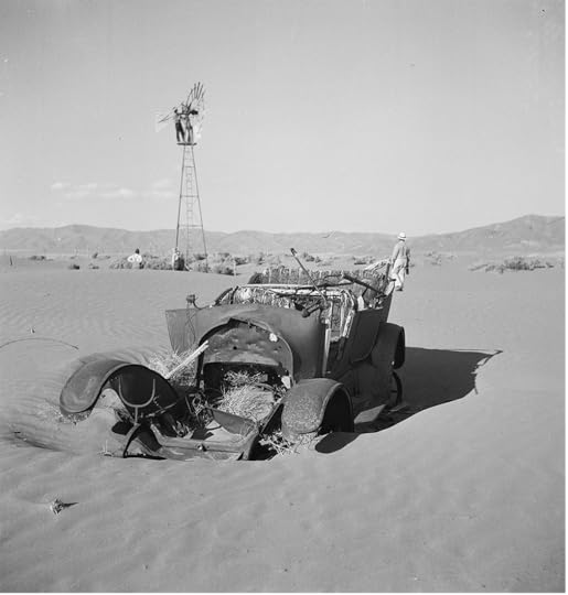 The “Centennial” skydiving show was in celebration of the Territorial Centennial in 1963.
Coverage of skydiving and everything else at Floating Feather Airport petered out in the early 1970s. Bill Woods sold the airport in 1972 to developers. He passed away in 1974.
Boise Air Park
You could still land at Boise Air Park today if you had a pontoon plane. It would scare the heck out of swimmers and stand-up paddle boarders, though. Quinns Pond is where the planes took off and landed, beginning in 1945.
Operators Haven Schoonover, Lloyd Eason, and Paul Parks promoted Boise Air Park as the city’s “downtown airport.” All of the area airports in the 40s, 50s, and 60s offered flight training. Boise Air Park created a lot of pilots, each of whom was listed in the local paper when they got their licenses. Ken Arnold,
of UFO fame
, flew out of there.
Boise Air Park closed sometime in the early 1950s.
Bradley Field
Bradley Field, or Bradley Airport, which you can think of in today’s terms as Garden City’s airport, started in 1946, shortly after operations began at Boise Air Park. Though Garden City didn’t exist during most of the airport’s life, it was squarely in the middle of what is now the city.
There is some irony in using local landmarks to describe where the airport was. If you search for “Bradley Airport” in the Statesman archives, you could get the impression that being a landmark was the main purpose of the place. Houses for rent or for sale, accidents on the highway, business addresses—all were described by their relationship to Bradley Airport.
Here's a Google Maps view of Chinden Boulevard from the Fred Meyer Store on the left to 49th Street on the right, with an old aerial of Bradley Airport overlaid to pinpoint its location.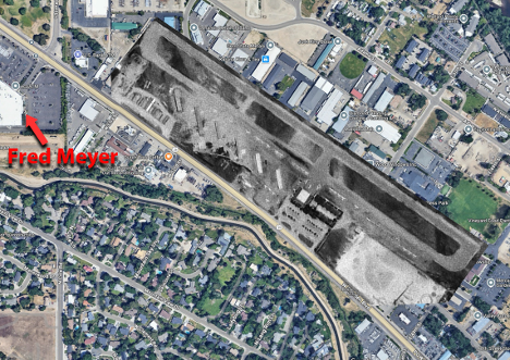 Bradley Airport covered 270 acres with a single 3,000-foot gravel northwest/southeast runway built by Morrison Knudsen Company. Some of the original buildings canted at 45 degrees to the runway, serve as storage units today.
Bradley Airport was built to serve as a “replacement airport” for Boise. That doesn’t mean that it replaced the main airport, only that private aircraft were encouraged to use it instead of the commercial airport.
On opening day in December 1946, the “resort” airport had a lounge with showers, a Skytel for overnight accommodations under construction, a Sky Store, aircraft shops, and a café. The airport offered private pilots some hangers and a lot of tie-down spots where they could keep their light planes. If you weren’t a pilot yet, there was training available.
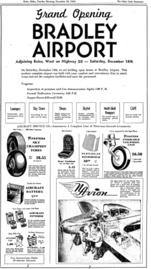 The Bradley Airport received one of the nation’s major aviation awards in 1948. The National Aeronautics Association named it the Best Close-to-City Resort Type Airpark. It operated profitably for years but was starting to be a financial strain on the owners by 1971. They asked the county to take over the operation of Bradley Field.
Commissioners considered it. Taxpayers revolted, and the owners sold the property to a developer. Bradley Airport closed on February 22, 1973.
Strawberry Glenn
This airfield, where the Riverside residential area is now north of the Boise River and west of Glenwood, has been called many things. The original name, when farmer Bill Thomas first developed it in 1946, was the Green Meadow Airport. It was a cow pasture airport serving the needs of pilots with surplus planes and Piper Cubs.
Thomas sold the field to Harold Major, who called it Major’s Field until he sold it to Laddie Campbell, making it Campbell Airpark. George Dovel came along and purchased the strip but didn’t name it after himself, calling it Gem Heliport, with an emphasis on helicopters.
You could get flight instruction at the Gem Heliport, both fixed wing and rotary. You could also charter back-country flights.
In 1962, Harry Stone took over the operation and it became Stone Airport. Through all the owners, facilities at the little airport improved and expanded.
In 1968 or 69, Jack Hoke took over and officially named the field Strawberry Glenn Airport, something locals had been calling it for some time. A fire at the field’s only hanger destroyed the building and soon effectively closed the airport to the public.
In 1973, as Bradley Airport was flying the coop, Strawberry Glenn was reopening with expansion plans. The airport hosted fly-ins, small airshows, and the Strawberry Glenn Pilots Association through the 70s.
In 1979, Garden City began floating the idea of making Strawberry Glenn a municipal airport for general aviation. It would function as a “replacement” or “reliever” for Boise Airport. Owner Jack Hoke already had a housing developer lined up with a purchase option.
Garden City Mayor Ray Eld, a pilot himself, pushed the idea. It became a campaign issue, and probably one of the reasons the long-time mayor was defeated. The idea of purchasing Strawberry Glenn evaporated with the election. Strawberry Glenn was sold, and the site became the Riverside subdivision.
Harry Stone, who owned the airport in the early 60s explained why private airports were going broke in a 1970 Idaho Statesman interview. “The only money you can make is through sale of parts, storage, and aircraft maintenance. Yet, you are required to have a large number of profitless acres for landing—all on which you have to pay taxes.”
That, and the fading interest in becoming a pilot, spelled the end of Boise’s private airports after more than 30 years in operation.
World War II created somewhere near 500,000 pilots. After the war, many of them wanted to continue flying. The war created pilots in another way, too. GIs returning from combat found that they could use money from the GI Bill to train for future careers. With all that training money, hundreds of flight schools popped up around the country.
Prognosticators following the war predicted that airplanes would be as cheap as automobiles and nearly as common. They envisioned airplane communities where you would roll your plane out of its garage in the morning and take off for work from an adjacent community airstrip.
Commercial aviation boomed, too. The war had turned aviation into the largest manufacturing industry in the world.
In a sense, private aviation and commercial aviation were in a race for the hearts of the American people. Commercial aviation won. Airplane ownership proved too costly for the average household. Meanwhile, commercial travel got cheaper and more accessible.
That’s a little background on why Boise had five airports at one time, but today, gets along with only three in the entire Treasure Valley: the Boise Airport (BOI), the Nampa Municipal Airport, and the Caldwell Industrial Airport. If you count Emmett as part of the Treasure Valley, they have a small municipal airport there, too.
The Boise Airport
The history of the Boise Airport is fairly well known, so I won’t spend a lot of time on that. Suffice to say that the original airport, named Booth Field but rarely called that, was built next to the Boise River, where Boise State University is today. The property was purchased from William T. Booth in 1926 and quickly readied for service.
Passenger service was far in the future, and nearly no one knew how to fly. So, why did Boise need a municipal airport? Air mail. Boise was part of the first commercial air mail route, which included stops in Elko, Nevada, and Pasco, Washington.
The contract for air mail service had already been awarded to Varney Airlines to begin service on April 6, 1926. They needed a place to land in Boise.
The community came together to build an airport.
On April 6, the runway was ready. The citizens turned out to celebrate. Then word came out about the missing pilot.
Telescoping a lot of history into a sentence, Varney Airlines had some success, eventually carrying passengers as well as mail, until they joined forces with other companies to create United Airlines in 1931. That’s why you’ll see a plaque at BOI declaring it the home of United Airlines. The need for better facilities and longer runways led to the development of that airport on the site we know today in 1936.
But what about Boise’s other airports? A reader who had found a map that mentioned two or three others asked me what I knew about them. Not a lot, until now.
Multiple Airports
At one point in 1946, there were five Boise airports, counting Floating Feather Airport, which was near Eagle. The Boise Airport had been operating for nine years, but Jr. College Field or College Field, where the original airport was, still operated. Boise Air Park came online, as did Bradley Field. These airports, or ‘Ports, as the Statesman sometimes called them, all competed for pilots and to make new pilots.
Here’s a brief description of each.
Floating Feather Airport
Located northeast of the intersection of Highway 55 and East Floating Feather Road, this landing strip opened in 1940 and was developed by Bill Woods. It was Boise’s first privately owned airport. Woods put up a wooden 12-plane hanger that first year.
Woods named the airport, and the name soon attached to the road. He thought it was a good name because he remembered so often bringing his aircraft “down the runway like a feather.” His planes were branded with a five-foot pair of wings in flashing bronze and black on each side, with “Boise Valley Flying Service” centered above the wings.
Student pilots at Floating Feather included the Northwest Nazarene College Flyers.
Many of the “Flying Heels,” a group of female stenographers determined to fly, did their training there, too. A flying club called the “Flying Feathers” began meeting and training at the airport in 1941.
Business was good at the Floating Feather Airport. They built a second hanger in 1942. Governor Chase Clark popped by in June to give awards to Civil Air Patrol members.
In April of 1943, student pilots at Floating Feather announced that they believed their instructor, Bill Woods, had set a record by soloing 467 students over a three-year period.
In addition to instruction, most of the airport operators flew hunters and anglers into what was then known as the “primitive area” of Central Idaho. None were more famous for it than Bill Woods. In a 1969 interview with the Idaho Statesman, he estimated that he had 29,000 hours of backcountry flying under his belt. In addition to sportsmen, Woods flew supplies to remote ranches. During the terrible winter of 1949, he was the lifeline for many living in the backcountry, even flying in milk for a baby.
Woods flew missions for Idaho Fish and Game, dropping feed for deer and elk, and famously conducting the first aerial roundup of antelope for the agency
This 1948 ad was one of many that christened Bill Woods “The Old Man of the Mountains.” When reminiscing about his time running Floating Feather Airport, Woods said everything was divided into eras: Before the crash and after.
The crash happened about 9:30 pm on June 28, 1944. The Floating Feather Airport wasn’t the home base for the airplane when tragedy struck the airport, quite literally. An Army B-24 Liberator based at Gowen Field caught fire over West Boise. The pilot, probably attempting to land at the nearest airport, flew toward Floating Feather. Witnesses said the flames were intermittent at first. The plane exploded over the airport and went down about 200 feet from the wooden hanger, setting it on fire. Debris from the explosion scattered over a three-mile area, setting multiple fires. Three small planes, a car, a road grader, and the hanger all burned.
Eight men perished in the explosion of the plane. Two parachuted to safety, and the tail gunner was able to crawl out of the wreckage on the ground.
The crash and resultant fires attracted onlookers driving 2,000 cars to the highway adjacent to the airport.
An Army B-24 Liberator based at Gowen Field, like the one above, exploded and set fire to the Floating Feather Airport in 1944. The Floating Feather Airport began operating again two weeks after the crash, but things were never quite the same.
As might be expected at a busy airport that catered to student pilots, there were several minor crashes there over the years. One fatality took place in 1943 when 23-year-old Frank Tweedy, an experienced smoke jumper, attempted a recreational parachute jump. He bailed out at 3,000 feet. Whether the jumper misjudged the distance to the ground, or the parachute was defective, it did not open.
Hundreds more successful jumps followed as the Boise Skydivers Club and the Alate Parachute Club called the airport home in later years. The skydivers began to outnumber the student pilots in the 1950s and 60s. They gave regular demonstrations and hosted multi-state skydiving meets. The Statesman often covered their exploits, ignoring the new pilots that soloed during that period.
The “Centennial” skydiving show was in celebration of the Territorial Centennial in 1963. Coverage of skydiving and everything else at Floating Feather Airport petered out in the early 1970s. Bill Woods sold the airport in 1972 to developers. He passed away in 1974.
Boise Air Park
You could still land at Boise Air Park today if you had a pontoon plane. It would scare the heck out of swimmers and stand-up paddle boarders, though. Quinns Pond is where the planes took off and landed, beginning in 1945.
Operators Haven Schoonover, Lloyd Eason, and Paul Parks promoted Boise Air Park as the city’s “downtown airport.”
All of the area airports in the 40s, 50s, and 60s offered flight training. Boise Air Park created a lot of pilots, each of whom was listed in the local paper when they got their licenses. Ken Arnold,
of UFO fame
, flew out of there.Boise Air Park closed sometime in the early 1950s.
Bradley Field
Bradley Field, or Bradley Airport, which you can think of in today’s terms as Garden City’s airport, started in 1946, shortly after operations began at Boise Air Park. Though Garden City didn’t exist during most of the airport’s life, it was squarely in the middle of what is now the city.
There is some irony in using local landmarks to describe where the airport was. If you search for “Bradley Airport” in the Statesman archives, you could get the impression that being a landmark was the main purpose of the place. Houses for rent or for sale, accidents on the highway, business addresses—all were described by their relationship to Bradley Airport.
Here's a Google Maps view of Chinden Boulevard from the Fred Meyer Store on the left to 49th Street on the right, with an old aerial of Bradley Airport overlaid to pinpoint its location.
Bradley Airport covered 270 acres with a single 3,000-foot gravel northwest/southeast runway built by Morrison Knudsen Company. Some of the original buildings canted at 45 degrees to the runway, serve as storage units today. Bradley Airport was built to serve as a “replacement airport” for Boise. That doesn’t mean that it replaced the main airport, only that private aircraft were encouraged to use it instead of the commercial airport.
On opening day in December 1946, the “resort” airport had a lounge with showers, a Skytel for overnight accommodations under construction, a Sky Store, aircraft shops, and a café. The airport offered private pilots some hangers and a lot of tie-down spots where they could keep their light planes. If you weren’t a pilot yet, there was training available.
The Bradley Airport received one of the nation’s major aviation awards in 1948. The National Aeronautics Association named it the Best Close-to-City Resort Type Airpark. It operated profitably for years but was starting to be a financial strain on the owners by 1971. They asked the county to take over the operation of Bradley Field.Commissioners considered it. Taxpayers revolted, and the owners sold the property to a developer. Bradley Airport closed on February 22, 1973.
Strawberry Glenn
This airfield, where the Riverside residential area is now north of the Boise River and west of Glenwood, has been called many things. The original name, when farmer Bill Thomas first developed it in 1946, was the Green Meadow Airport. It was a cow pasture airport serving the needs of pilots with surplus planes and Piper Cubs.
Thomas sold the field to Harold Major, who called it Major’s Field until he sold it to Laddie Campbell, making it Campbell Airpark. George Dovel came along and purchased the strip but didn’t name it after himself, calling it Gem Heliport, with an emphasis on helicopters.
You could get flight instruction at the Gem Heliport, both fixed wing and rotary. You could also charter back-country flights.
In 1962, Harry Stone took over the operation and it became Stone Airport. Through all the owners, facilities at the little airport improved and expanded.
In 1968 or 69, Jack Hoke took over and officially named the field Strawberry Glenn Airport, something locals had been calling it for some time. A fire at the field’s only hanger destroyed the building and soon effectively closed the airport to the public.
In 1973, as Bradley Airport was flying the coop, Strawberry Glenn was reopening with expansion plans. The airport hosted fly-ins, small airshows, and the Strawberry Glenn Pilots Association through the 70s.
In 1979, Garden City began floating the idea of making Strawberry Glenn a municipal airport for general aviation. It would function as a “replacement” or “reliever” for Boise Airport. Owner Jack Hoke already had a housing developer lined up with a purchase option.
Garden City Mayor Ray Eld, a pilot himself, pushed the idea. It became a campaign issue, and probably one of the reasons the long-time mayor was defeated. The idea of purchasing Strawberry Glenn evaporated with the election. Strawberry Glenn was sold, and the site became the Riverside subdivision.
Harry Stone, who owned the airport in the early 60s explained why private airports were going broke in a 1970 Idaho Statesman interview. “The only money you can make is through sale of parts, storage, and aircraft maintenance. Yet, you are required to have a large number of profitless acres for landing—all on which you have to pay taxes.”
That, and the fading interest in becoming a pilot, spelled the end of Boise’s private airports after more than 30 years in operation.
June 16, 2025
A Little Hydroplane History
Editor's note: I'll post new stories on my Facebook page once or twice a month. If you'd like to get a new story every week, along with a lot of other content, click Subscribe at the top right of this page.
We’re flying into a bit of Idaho hydroplane history today. If you think of a thundering race boat when you hear the term hydroplane, take heart. That’s where we’re headed. But first, we need to look at the evolution of the term.
The first reference to a hydroplane that I found in an Idaho newspaper included this drawing.
This boat used airplane propellers much like snow planes did in Idaho many years later. One could also postulate that this was the grandfather of the airboat that became popular for swamp travel.
In any case, this 1907 Italian invention was decidedly a boat that was called a hydroplane. The same paper in the same year reported a hydroplane being demonstrated on the Great Salt Lake by aviation pioneer Glenn Curtiss. The pilot landed and took off from the water in his airplane equipped with pontoons. They called it a hydroplane.
Meanwhile, boaters in the Eastern states were competing for loving cups in their monstrous boats called hydroplanes. Some of them reached speeds of 40 miles per hour in 1911. At the same time, the secretary of the Navy was ordering what he called hydroplanes for use in war.
In 1912, the Idaho Statesman ran a feature article about “The Healthiest Sport in the World,” which any fool would know was motorboat racing, referred to often in the article as hydroplaning.
So, let’s pause here for a moment to explore the term. Hydro—water—combined with the word plane, logically would lead one to believe this was an airplane that could land on and take off from water. Point for the pilots.
But hydroplaning is a water-based activity. Let’s have our friends at Wikipedia explain.
“A key aspect of hydroplanes is that they use the water they are on for lift rather than buoyancy, as well as for propulsion and steering: when travelling at high speed water is forced downwards by the bottom of the boat's hull. The water therefore exerts an equal and opposite force upwards, lifting the vast majority of the hull out of the water. This process, happening at the surface of the water, is known as 'foiling.'”
Confusion about the term was rampant in the first half of the 20th Century. Newspaper reports used it to refer to airplanes just as often as for racing boats. But gradually, airplanes with pontoons became seaplanes, float planes, flying boats, and pontoon planes. By the 1950s, if it was a hydroplane, it was a roaring racing boat that you meant.
Roaring? Absolutely. Often called thunderboats, these hydroplaning monsters typically had 12-cylinder Rolls Royce or Allison airplane engines that had never seen a muffler.
Also, by the 1950s, unimaginable 40-mph boats were breaking records at 140-mph+.
Hydroplane aficionados in Idaho had to read about the Slo-Mo-Shun IV and Miss Bardhal in the papers and listen to the races on the radio from Seattle and San Francisco until 1958. That was the year hydros first came to Lake Coeur d’Alene.
The tables turned for Idaho boating fans when KING TV from Seattle broadcast the first Diamond Cup races from Coeur d’Alene. Maverick out of Las Vegas one the first and second cups in ’58 and ’59. Seattle Too took the trophy in 1960. Another Seattle boat, Miss Thriftway won in ’61, ’62, and ’63. Miss Exide took the trophy home for Seattle in ’64 and ’65. In 1966, Tahoe Miss out of Reno brought home the prize. There was no race in ’67. In 1968, Miss Bardahl won the Diamond Cup.
And that was it, for 45 years. There was talk many times of bringing the race back to Coeur d’Alene, but no one mustered up the money or the army of volunteers it takes to put on a race that drew up to 50,000 spectators. The citizens of city also soured on the event when crowds were sometimes rowdy. The bleachers for the race were long ago removed from their vantage point on Tubbs Hill.
Then, in 2013, promoters brought the races back for a long Labor Day Weekend of unlimited hydroplane racing. The event was expected to bring 30,000 spectators and about $12 million to Coeur d’Alene. It fell far short of that on both counts, and the Diamond Cup event was dropped, never to return since.
Hydroplane racing has taken place in other Idaho locations, notably near Payette and in Burley on the Snake River. While the racers are running powerful boats, they aren’t the “unlimited” hydroplanes that ran on Lake Coeur d’Alene.
By the way, the world speed record for hydroplanes was 317.596 mph the last time I looked. That was set in 1978 by Ken Warby in the Spirit of Australia at Blowering Dam in New South Wales, Australia.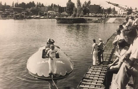 Miss Bardahl at one of the Diamond Cup races in Coeur d’Alene.
This is the memorial to a hydroplane racer near the Coeur d’Alene Resort. It honors Warner Gardner, who raced many times on the lake and was a crowd favorite. When hydroplane race driver Mira Slovak crashed on the lake in 1963, his boat turning into toothpicks, Gardner jumped from his own boat to save him. The memorial depicts an F-86 fighter jet suspended above a bronze hydroplane in honor of the former Air Force pilot who died in a 1968 hydroplane crash in Detroit.
We’re flying into a bit of Idaho hydroplane history today. If you think of a thundering race boat when you hear the term hydroplane, take heart. That’s where we’re headed. But first, we need to look at the evolution of the term.
The first reference to a hydroplane that I found in an Idaho newspaper included this drawing.
This boat used airplane propellers much like snow planes did in Idaho many years later. One could also postulate that this was the grandfather of the airboat that became popular for swamp travel.
In any case, this 1907 Italian invention was decidedly a boat that was called a hydroplane. The same paper in the same year reported a hydroplane being demonstrated on the Great Salt Lake by aviation pioneer Glenn Curtiss. The pilot landed and took off from the water in his airplane equipped with pontoons. They called it a hydroplane.
Meanwhile, boaters in the Eastern states were competing for loving cups in their monstrous boats called hydroplanes. Some of them reached speeds of 40 miles per hour in 1911. At the same time, the secretary of the Navy was ordering what he called hydroplanes for use in war.
In 1912, the Idaho Statesman ran a feature article about “The Healthiest Sport in the World,” which any fool would know was motorboat racing, referred to often in the article as hydroplaning.
So, let’s pause here for a moment to explore the term. Hydro—water—combined with the word plane, logically would lead one to believe this was an airplane that could land on and take off from water. Point for the pilots.
But hydroplaning is a water-based activity. Let’s have our friends at Wikipedia explain.
“A key aspect of hydroplanes is that they use the water they are on for lift rather than buoyancy, as well as for propulsion and steering: when travelling at high speed water is forced downwards by the bottom of the boat's hull. The water therefore exerts an equal and opposite force upwards, lifting the vast majority of the hull out of the water. This process, happening at the surface of the water, is known as 'foiling.'”
Confusion about the term was rampant in the first half of the 20th Century. Newspaper reports used it to refer to airplanes just as often as for racing boats. But gradually, airplanes with pontoons became seaplanes, float planes, flying boats, and pontoon planes. By the 1950s, if it was a hydroplane, it was a roaring racing boat that you meant.
Roaring? Absolutely. Often called thunderboats, these hydroplaning monsters typically had 12-cylinder Rolls Royce or Allison airplane engines that had never seen a muffler.
Also, by the 1950s, unimaginable 40-mph boats were breaking records at 140-mph+.
Hydroplane aficionados in Idaho had to read about the Slo-Mo-Shun IV and Miss Bardhal in the papers and listen to the races on the radio from Seattle and San Francisco until 1958. That was the year hydros first came to Lake Coeur d’Alene.
The tables turned for Idaho boating fans when KING TV from Seattle broadcast the first Diamond Cup races from Coeur d’Alene. Maverick out of Las Vegas one the first and second cups in ’58 and ’59. Seattle Too took the trophy in 1960. Another Seattle boat, Miss Thriftway won in ’61, ’62, and ’63. Miss Exide took the trophy home for Seattle in ’64 and ’65. In 1966, Tahoe Miss out of Reno brought home the prize. There was no race in ’67. In 1968, Miss Bardahl won the Diamond Cup.
And that was it, for 45 years. There was talk many times of bringing the race back to Coeur d’Alene, but no one mustered up the money or the army of volunteers it takes to put on a race that drew up to 50,000 spectators. The citizens of city also soured on the event when crowds were sometimes rowdy. The bleachers for the race were long ago removed from their vantage point on Tubbs Hill.
Then, in 2013, promoters brought the races back for a long Labor Day Weekend of unlimited hydroplane racing. The event was expected to bring 30,000 spectators and about $12 million to Coeur d’Alene. It fell far short of that on both counts, and the Diamond Cup event was dropped, never to return since.
Hydroplane racing has taken place in other Idaho locations, notably near Payette and in Burley on the Snake River. While the racers are running powerful boats, they aren’t the “unlimited” hydroplanes that ran on Lake Coeur d’Alene.
By the way, the world speed record for hydroplanes was 317.596 mph the last time I looked. That was set in 1978 by Ken Warby in the Spirit of Australia at Blowering Dam in New South Wales, Australia.
Miss Bardahl at one of the Diamond Cup races in Coeur d’Alene.
This is the memorial to a hydroplane racer near the Coeur d’Alene Resort. It honors Warner Gardner, who raced many times on the lake and was a crowd favorite. When hydroplane race driver Mira Slovak crashed on the lake in 1963, his boat turning into toothpicks, Gardner jumped from his own boat to save him. The memorial depicts an F-86 fighter jet suspended above a bronze hydroplane in honor of the former Air Force pilot who died in a 1968 hydroplane crash in Detroit.May 27, 2025
The First Mid-Air Collision in Idaho History
Editor's note: I'll post new stories on my Facebook page about once a month. If you'd like to get a new story every week, along with a lot of other content, click Subscribe at the top right of this page.
In July 1969, the Boise Chamber of Commerce hosted a fly-in breakfast that took businesspeople from the area by plane to Smiley Creek, the highest tributary to the Salmon River. By all reports, the breakfast was a success, with more than 30 planes landing on the dirt strip to deposit guests for a morning repast.
In addition to the businesspeople in attendance, Idaho Director of Aeronautics Chet Moulton, Idaho Wheat Commissioner Harold West, and Secretary of State Pete Cenarussa were there. Cenarussa, a sheep rancher who flew himself in, got a little flack from the hosts about whether or not he’d been looking for sheep on the way to Smiley Creek.
Bob Lorimer, the Statesman staff writer who attended, wrote, “Everything clicked. The crisp, cool air was invigorating. The smell of bacon, eggs, and hash brown potatoes had that special 7,100-ft altitude aroma.”
Lorimer joked that he’d saved himself six-bits when he opted for a $15,000 insurance policy for the day, rather than the one that cost two dollars for $25,000. He was on his way home from the airport when he noticed a spiral of white smoke on the foothills. He didn’t think much of it, assuming it was just another grass fire.
Dozens of people in Boise had seen what Lorimer missed. Two small planes returning from the breakfast met wing-to-wing in mid-air over Boise’s North End.
The two planes glance off in different directions into the residential area, one narrowly missing a kindergarten. Miraculously, though debris fell out of the sky for blocks, there was little damage and no injuries on the ground.
One of the planes, a Model V35 Beechcraft Bonanza, clipped a power pole and nosed into a field behind a home at 61 E Horizon Drive, bursting into flames. Aboard were the pilot, Kenneth F. Flannery of LaGrande Oregon, Donald J. Ruzicka, of Milwaukie, Oregon, Dr. R.M. Kingland of 1821 Edgecliff Terrace, Boise, and Vincent Aguirre, 3509 Windsor Drive, Boise, co-owner of the Royal Restaurant.
The second plane, a Cessna 210E piloted by Basil P. W. Clapin, 3321 North Cole Road, Boise, plunged to earth on Fifth Street near the intersection with Union. Boise Attorney Eugene C. Smith, 7105 Brookover Drive, was also on board.
All six men in Idaho’s first mid-air collision were killed.
Many Boise residents witnessed the crash and marveled that no one on the ground was hurt by the debris that rained down.
John Larsen saw the aftermath of the crash and wrote a first person story about it for Idaho Magazine. You can read that here.
The first mid-air collision in Idaho wouldn’t be the last. Three mid-air collisions occurred over central Idaho, one in 2008 that killed three people, and collisions in 2013 and 2014 that killed one person each. In 2020, the state’s worst mid-air collision happened over Lake Coeur d’Alene, killing 8.
 Cessna 210E plunged to earth on Fifth Street near the intersection with Union. ITD archival photo.
 A Model V35 Beechcraft Bonanza clipped a power pole and nosed into a field behind a home on Horizon Drive, bursting into flames. ITD archival photo.
In July 1969, the Boise Chamber of Commerce hosted a fly-in breakfast that took businesspeople from the area by plane to Smiley Creek, the highest tributary to the Salmon River. By all reports, the breakfast was a success, with more than 30 planes landing on the dirt strip to deposit guests for a morning repast.
In addition to the businesspeople in attendance, Idaho Director of Aeronautics Chet Moulton, Idaho Wheat Commissioner Harold West, and Secretary of State Pete Cenarussa were there. Cenarussa, a sheep rancher who flew himself in, got a little flack from the hosts about whether or not he’d been looking for sheep on the way to Smiley Creek.
Bob Lorimer, the Statesman staff writer who attended, wrote, “Everything clicked. The crisp, cool air was invigorating. The smell of bacon, eggs, and hash brown potatoes had that special 7,100-ft altitude aroma.”
Lorimer joked that he’d saved himself six-bits when he opted for a $15,000 insurance policy for the day, rather than the one that cost two dollars for $25,000. He was on his way home from the airport when he noticed a spiral of white smoke on the foothills. He didn’t think much of it, assuming it was just another grass fire.
Dozens of people in Boise had seen what Lorimer missed. Two small planes returning from the breakfast met wing-to-wing in mid-air over Boise’s North End.
The two planes glance off in different directions into the residential area, one narrowly missing a kindergarten. Miraculously, though debris fell out of the sky for blocks, there was little damage and no injuries on the ground.
One of the planes, a Model V35 Beechcraft Bonanza, clipped a power pole and nosed into a field behind a home at 61 E Horizon Drive, bursting into flames. Aboard were the pilot, Kenneth F. Flannery of LaGrande Oregon, Donald J. Ruzicka, of Milwaukie, Oregon, Dr. R.M. Kingland of 1821 Edgecliff Terrace, Boise, and Vincent Aguirre, 3509 Windsor Drive, Boise, co-owner of the Royal Restaurant.
The second plane, a Cessna 210E piloted by Basil P. W. Clapin, 3321 North Cole Road, Boise, plunged to earth on Fifth Street near the intersection with Union. Boise Attorney Eugene C. Smith, 7105 Brookover Drive, was also on board.
All six men in Idaho’s first mid-air collision were killed.
Many Boise residents witnessed the crash and marveled that no one on the ground was hurt by the debris that rained down.
John Larsen saw the aftermath of the crash and wrote a first person story about it for Idaho Magazine. You can read that here.
The first mid-air collision in Idaho wouldn’t be the last. Three mid-air collisions occurred over central Idaho, one in 2008 that killed three people, and collisions in 2013 and 2014 that killed one person each. In 2020, the state’s worst mid-air collision happened over Lake Coeur d’Alene, killing 8.
Cessna 210E plunged to earth on Fifth Street near the intersection with Union. ITD archival photo. A Model V35 Beechcraft Bonanza clipped a power pole and nosed into a field behind a home on Horizon Drive, bursting into flames. ITD archival photo.
April 29, 2025
Dreams of Rippling Wheat Fields Shattered
Editor's note: I'll post new stories on my Facebook page about once a month. If you'd like to get a new story every week, along with a lot of other content, click Subscribe at the top right of this page.
Years of drought in the Midwest, combined with unsustainable farming practices, brought on the Dust Bowl in the 1930s. Did you think Idaho was spared? Not entirely.
The drought in the 30s spread into Idaho, but since most farms in the arid southern part of the state were gravity irrigated, the impact was not as severe. There were exceptions, though, particularly in Oneida and Cassia counties west of Malad, where hardscrabble farmers were trying to eke out a living from dryland agriculture.
Land that naturally grew grass and sagebrush could not sustain crops when rainfall was scarce. In Idaho, the 1930s witnessed the most severe drought periods on record, with extreme drought conditions occurring in 7 out of 12 years from 1929-1940. Some Idaho farmers found themselves surrounded by drifting sand instead of healthy row crops.
Children playing in the drifted sand in Oneida County, 1935. Library of Congress.
President Franklin D. Roosevelt created the Resettlement Administration as part of his New Deal program to help citizens get back on their feet. In Idaho, that meant buying out about 100 failing farms in Oneida and Cassia counties and assisting the families with relocation, mainly in Oregon’s Willamette Valley and in Northern Idaho. The government provided low-interest loans and grants to get the farmers producing again.
Most struggling farm families had quit paying taxes, so county and school coffers were empty. More than 100 submarginal farms had already been abandoned and were owned by the counties when the federal government stepped in.
 A photo caption on the Library of Congress website sums up the problem: “The tract on which these buildings stand should never have been farmed, but it took protracted drought to drive that lesson home.”
R.R. Best, the project manager, as quoted in the Idaho Statesman, said, “The expenditure of approximately $409,000 for private and county lands will make possible payment of thousands of dollars in delinquent taxes to the county, consolidation or retirement of several school districts, and give many of the settlers sufficient cash to aid relocation.”
Relocating or tearing down farm buildings and removing fencing put about 100 men to work. They removed 187 miles of old fence and made 10,000 juniper posts to build 1,000 miles of new fence to protect the grassland.
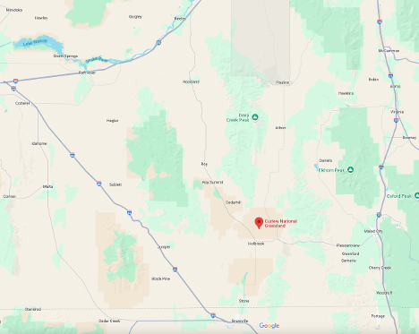
The Forest Service became the new land manager of what is now about 47,000 acres of public and formerly private land, turning it back to cover that would be sustainable. That area is now known as the Curlew National Grasslands.
To get to the Curlew National Grasslands, first go to Utah. Take I-84 south to Snowville, then head north back across the Idaho line to Holbrook.
In a 1937 report from the Resettlement Administration, D.L. Bush, the Idaho director, noted that 6,000 farm families had received help at some level, including loans averaging about $1,400 and assistance grants to 3,333 destitute families.
The administration took pains to point out that no one was forced off their land. Relocation and buyouts were voluntary.
Today, if you drive between Holbrook and Malad City on the nearly deserted road between them—as I often have—you’ll see little sign that the land there was once dotted with the farms of people whose hopes withered in the summer sun.
Years of drought in the Midwest, combined with unsustainable farming practices, brought on the Dust Bowl in the 1930s. Did you think Idaho was spared? Not entirely.
The drought in the 30s spread into Idaho, but since most farms in the arid southern part of the state were gravity irrigated, the impact was not as severe. There were exceptions, though, particularly in Oneida and Cassia counties west of Malad, where hardscrabble farmers were trying to eke out a living from dryland agriculture.
Land that naturally grew grass and sagebrush could not sustain crops when rainfall was scarce. In Idaho, the 1930s witnessed the most severe drought periods on record, with extreme drought conditions occurring in 7 out of 12 years from 1929-1940. Some Idaho farmers found themselves surrounded by drifting sand instead of healthy row crops.
Children playing in the drifted sand in Oneida County, 1935. Library of Congress. President Franklin D. Roosevelt created the Resettlement Administration as part of his New Deal program to help citizens get back on their feet. In Idaho, that meant buying out about 100 failing farms in Oneida and Cassia counties and assisting the families with relocation, mainly in Oregon’s Willamette Valley and in Northern Idaho. The government provided low-interest loans and grants to get the farmers producing again.
Most struggling farm families had quit paying taxes, so county and school coffers were empty. More than 100 submarginal farms had already been abandoned and were owned by the counties when the federal government stepped in.
A photo caption on the Library of Congress website sums up the problem: “The tract on which these buildings stand should never have been farmed, but it took protracted drought to drive that lesson home.” R.R. Best, the project manager, as quoted in the Idaho Statesman, said, “The expenditure of approximately $409,000 for private and county lands will make possible payment of thousands of dollars in delinquent taxes to the county, consolidation or retirement of several school districts, and give many of the settlers sufficient cash to aid relocation.”
Relocating or tearing down farm buildings and removing fencing put about 100 men to work. They removed 187 miles of old fence and made 10,000 juniper posts to build 1,000 miles of new fence to protect the grassland.
The Forest Service became the new land manager of what is now about 47,000 acres of public and formerly private land, turning it back to cover that would be sustainable. That area is now known as the Curlew National Grasslands.
To get to the Curlew National Grasslands, first go to Utah. Take I-84 south to Snowville, then head north back across the Idaho line to Holbrook. In a 1937 report from the Resettlement Administration, D.L. Bush, the Idaho director, noted that 6,000 farm families had received help at some level, including loans averaging about $1,400 and assistance grants to 3,333 destitute families.
The administration took pains to point out that no one was forced off their land. Relocation and buyouts were voluntary.
Today, if you drive between Holbrook and Malad City on the nearly deserted road between them—as I often have—you’ll see little sign that the land there was once dotted with the farms of people whose hopes withered in the summer sun.
March 26, 2025
The Bravery of Bernie Fisher
Editor's note: I'll post new stories on my Facebook page about once a month. If you'd like to get a new story every week, along with a lot of other content, click Subscribe at the top right of this page.
Bernard (pronounced Bernerd) Fisher went by the nickname Bernie. He’d grown up in Utah. Late in World War II, he served briefly in the Navy. While he was in the service, his family moved to Kuna. When he got out, he joined them, calling Kuna home thereafter.
Fisher attended Boise Junior College, playing in the marching band, before getting his degree from the University of Utah in 1951. He received a commission in the Air Force shortly after. That career took him and his wife, Realla, worldwide. In 1965, the fighter pilot volunteered for duty in Vietnam.
On March 9, Major Fisher showed his bravery while flying support for a special forces camp that was under attack in the A Shau Valley, for which he received the Silver Star. But that battle was overshadowed by the events at the same place the next day.
The 1500-foot hills around the base were obscured by clouds, giving the support aircraft in the battle a narrow window below 800 feet, forcing them down within range of North Vietnamese rifle fire.
Colonel Dafford (Jump) Meyers took fire that disabled his A1 fighter, forcing him to crash-land it on the makeshift field. He jumped from his plane and sprinted to a dirt embankment, behind which the enemy was dug in.
In a 1966 UPI interview, Meyers said, “There was simply too much firepower for a chopper to get down to pick me up, and I figured I had only about 15 minutes to live once our planes had to leave.”
The other fighters had already run out of ammunition. Fuel was getting low.
Myers saw Major Bernie Fisher coming down and assumed he’d taken fire and was crash-landing, too. “I never thought for a moment he was coming down for me,” Myers said. “There was so much firepower down there that if I’d have had a radio, I’d have told them to get the heck out of there.”
“When he rolled in to land, I just assumed he had been hit. Then he comes taxing back up the field looking for me. What a feeling that was when I realized he was there to get me.”
Asked if he’d have done the same thing if the situation was reversed, Myers said, “I don’t know. I’ve thought about that many times, but I don’t think I would have ever been faced with the decision, because it just wouldn’t have crossed my mind to go in there. I’ve asked many other pilots the same thing since then, and I haven’t found anybody yet that would have even thought of it. Bernie Fisher…he’s different that way.”
Bernie got Myer into the cockpit behind him, turned the plane around, and gunned it down the runway, taking fire as they went. The field was littered with battle debris and exploded aircraft. Bullets hit the A1-E 19 times. In a few seconds, they were into the clouds and out of sight, both uninjured.
Bernie Fisher was the first U.S. Air Force serviceman to receive the Medal of Honor, presented on January 19, 1967, by President Lyndon B. Johnson.
After retiring from the Air Force, Bernard Fisher spent the rest of his life on the family farm in Kuna. He passed away in 2014. His wife preceded him in death five years earlier. Bernie, a lifelong member of The Church of Jesus Christ of Latter-Day Saints, is buried in the Idaho State Veterans Cemetery in Boise. A park in Kuna is named in his honor, as is a street on Gowen Field.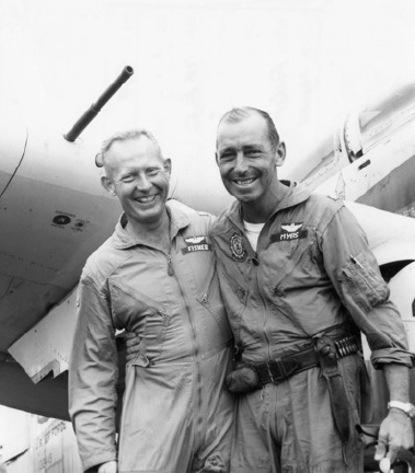 U.S. Air Force Majors Bernard F. Fisher and D.W. "Jump" Myers, in Vietnam, 10 March 1966. The photo was taken after Fisher's rescue of Myers from the A Shau Valley Special Forces camp airfield in front of Fisher's Douglas A-1E Skyraider (U.S. Navy BuNo 132649)
 Bernie Fisher in 2008. Photo by Staff Sgt. Darcie Ibidapo - www.af.mil, Public Domain, https://commons.wikimedia.org/w/index.php?curid=57076455
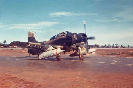 Douglas A-1-E Skyraider
Bernard (pronounced Bernerd) Fisher went by the nickname Bernie. He’d grown up in Utah. Late in World War II, he served briefly in the Navy. While he was in the service, his family moved to Kuna. When he got out, he joined them, calling Kuna home thereafter.
Fisher attended Boise Junior College, playing in the marching band, before getting his degree from the University of Utah in 1951. He received a commission in the Air Force shortly after. That career took him and his wife, Realla, worldwide. In 1965, the fighter pilot volunteered for duty in Vietnam.
On March 9, Major Fisher showed his bravery while flying support for a special forces camp that was under attack in the A Shau Valley, for which he received the Silver Star. But that battle was overshadowed by the events at the same place the next day.
The 1500-foot hills around the base were obscured by clouds, giving the support aircraft in the battle a narrow window below 800 feet, forcing them down within range of North Vietnamese rifle fire.
Colonel Dafford (Jump) Meyers took fire that disabled his A1 fighter, forcing him to crash-land it on the makeshift field. He jumped from his plane and sprinted to a dirt embankment, behind which the enemy was dug in.
In a 1966 UPI interview, Meyers said, “There was simply too much firepower for a chopper to get down to pick me up, and I figured I had only about 15 minutes to live once our planes had to leave.”
The other fighters had already run out of ammunition. Fuel was getting low.
Myers saw Major Bernie Fisher coming down and assumed he’d taken fire and was crash-landing, too. “I never thought for a moment he was coming down for me,” Myers said. “There was so much firepower down there that if I’d have had a radio, I’d have told them to get the heck out of there.”
“When he rolled in to land, I just assumed he had been hit. Then he comes taxing back up the field looking for me. What a feeling that was when I realized he was there to get me.”
Asked if he’d have done the same thing if the situation was reversed, Myers said, “I don’t know. I’ve thought about that many times, but I don’t think I would have ever been faced with the decision, because it just wouldn’t have crossed my mind to go in there. I’ve asked many other pilots the same thing since then, and I haven’t found anybody yet that would have even thought of it. Bernie Fisher…he’s different that way.”
Bernie got Myer into the cockpit behind him, turned the plane around, and gunned it down the runway, taking fire as they went. The field was littered with battle debris and exploded aircraft. Bullets hit the A1-E 19 times. In a few seconds, they were into the clouds and out of sight, both uninjured.
Bernie Fisher was the first U.S. Air Force serviceman to receive the Medal of Honor, presented on January 19, 1967, by President Lyndon B. Johnson.
After retiring from the Air Force, Bernard Fisher spent the rest of his life on the family farm in Kuna. He passed away in 2014. His wife preceded him in death five years earlier. Bernie, a lifelong member of The Church of Jesus Christ of Latter-Day Saints, is buried in the Idaho State Veterans Cemetery in Boise. A park in Kuna is named in his honor, as is a street on Gowen Field.
U.S. Air Force Majors Bernard F. Fisher and D.W. "Jump" Myers, in Vietnam, 10 March 1966. The photo was taken after Fisher's rescue of Myers from the A Shau Valley Special Forces camp airfield in front of Fisher's Douglas A-1E Skyraider (U.S. Navy BuNo 132649) Bernie Fisher in 2008. Photo by Staff Sgt. Darcie Ibidapo - www.af.mil, Public Domain, https://commons.wikimedia.org/w/index.php?curid=57076455
Douglas A-1-E SkyraiderMarch 18, 2025
The Idaho Rock Riot You Didn't Hear About
Editor's note: I'll post new stories on my Facebook page about once a month. If you'd like to get a new story every week, along with a lot of other content, click Subscribe at the top right of this page.
You and many other Idahoans who followed the news in 1976 may have missed this. The story is about a rock and roll riot that got washed to the back of newspapers because of the date it happened. The riot took place on the weekend of June 5, 1976. That was also the day the Teton Dam broke.
If you lived in North Idaho and were a fan of rock concerts, this one was a must-see. Bachman-Turner Overdrive (BTO) and Blue Oyster Cult were the headliners. You’d also see Flash Cadillac and the Continental Kids, Heart, and at least 26 other bands. They’d be playing June 4, 5 and 6 at Stateline, Idaho, at what was called Nor’wester ’76.
The tickets were a little steep: $30. But that was at the “door.” You could get them for 18 bucks if you bought them in advance, which plenty of people did. About 5,000 showed up that first evening to hear Blue Oyster Cult. The band did play, about five hours behind schedule. That was the high point.
On Saturday, the crowds came, but the bands didn’t. Promotors had allegedly sunk $250,000 into the festival and were out of money. Bands weren’t going to play unless they had cash upfront.
At about 3:30 on the afternoon of the 5th, word began to circulate that acts were canceling, and the “rock & roll storm” had blown out. Most attendees were outside the concert grounds when the riot started, but about 300 fans inside began expressing anger. They threw beer cans and bottles at crews trying to pack up equipment rapidly.
A cluster of small trailers set up backstage for performers became an easy target. Rioters set them on fire, then went after the heavy equipment parked nearby. A concession building caught fire. The crowd pushed a milk truck into the seating area and overturned it before setting it on fire. A tall crane toppled over onto the stage, where it was also set on fire. Propane tanks exploded, sending roiling black clouds into the air.
In all the chaos several people received minor injuries. Six went to area hospitals, one with a broken leg and another with a concussion.
At least 80 police officers were called out by the Kootenai County Sheriff’s Office and the Idaho State Police. Another 20 Washington State Patrol officers arrived to help direct traffic.
The Kootenai County prosecutor launched an investigation. Threats of lawsuits went back and forth, but the concert and the riot essentially ended that evening. This is the poster advertising the Stateline concert. Someone crossed out the bands that didn’t show on this copy.
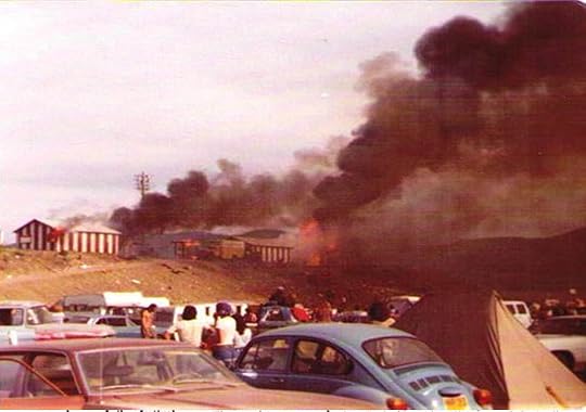 Buildings on fire during the rock riot.
 The remains of a burned-out truck.
 This crane was pushed over onto the stage and set on fire.
You and many other Idahoans who followed the news in 1976 may have missed this. The story is about a rock and roll riot that got washed to the back of newspapers because of the date it happened. The riot took place on the weekend of June 5, 1976. That was also the day the Teton Dam broke.
If you lived in North Idaho and were a fan of rock concerts, this one was a must-see. Bachman-Turner Overdrive (BTO) and Blue Oyster Cult were the headliners. You’d also see Flash Cadillac and the Continental Kids, Heart, and at least 26 other bands. They’d be playing June 4, 5 and 6 at Stateline, Idaho, at what was called Nor’wester ’76.
The tickets were a little steep: $30. But that was at the “door.” You could get them for 18 bucks if you bought them in advance, which plenty of people did. About 5,000 showed up that first evening to hear Blue Oyster Cult. The band did play, about five hours behind schedule. That was the high point.
On Saturday, the crowds came, but the bands didn’t. Promotors had allegedly sunk $250,000 into the festival and were out of money. Bands weren’t going to play unless they had cash upfront.
At about 3:30 on the afternoon of the 5th, word began to circulate that acts were canceling, and the “rock & roll storm” had blown out. Most attendees were outside the concert grounds when the riot started, but about 300 fans inside began expressing anger. They threw beer cans and bottles at crews trying to pack up equipment rapidly.
A cluster of small trailers set up backstage for performers became an easy target. Rioters set them on fire, then went after the heavy equipment parked nearby. A concession building caught fire. The crowd pushed a milk truck into the seating area and overturned it before setting it on fire. A tall crane toppled over onto the stage, where it was also set on fire. Propane tanks exploded, sending roiling black clouds into the air.
In all the chaos several people received minor injuries. Six went to area hospitals, one with a broken leg and another with a concussion.
At least 80 police officers were called out by the Kootenai County Sheriff’s Office and the Idaho State Police. Another 20 Washington State Patrol officers arrived to help direct traffic.
The Kootenai County prosecutor launched an investigation. Threats of lawsuits went back and forth, but the concert and the riot essentially ended that evening.
This is the poster advertising the Stateline concert. Someone crossed out the bands that didn’t show on this copy. Buildings on fire during the rock riot. The remains of a burned-out truck. This crane was pushed over onto the stage and set on fire.February 22, 2025
Russian Olives Were a Good Idea Gone Bad
I post my Speaking of Idaho blog occasionally on social media. If you'd like to see it more often, click the subscribe tab above.
Americans like to improve the places where they live. Sometimes, those improvements become such a part of our world that we forget they weren’t always here. The Russian olive tree, introduced to Idaho as an improvement, has taught us a lot about unintended consequences.
We’ll probably never pinpoint the first planting of a Russian olive tree in Idaho, but it was likely around 1906. The federal government was looking for tree species that would do well in the arid West, providing windbreaks while growing and fenceposts when harvested. The Russian olive filled the bill. It is tolerant of drought, floods, poor soil, and extreme temperatures.
By 1913, people were asking where they could get plants like those growing around the courthouse in Shoshone. The county clerk was also on the search in an effort to fill in hedge plants where some had died. He was having trouble finding a good source of seeds or young Russian olives. That scarcity didn’t last long.
J.F. Littooy, who had an office at 812 Bannock Street in Boise, was advertising trees of all kinds for purchase through his nursery the next year. Russian olives, sold as an ornamental tree, were 50 cents each.
In 1919, the University of Idaho School of Forestry began encouraging the planting of Russian olives with their pamphlet “Forest and Shade Trees for Planting in Idaho.” They would do so through the 1950s and 60s.
The University had 12 demonstration forests in Southern Idaho in 1927 to serve as “window displays” to promote the planting of trees. The forests consisted of woodlots, shelter belts, and windbreaks. They planted the trees six feet apart to permit horse cultivation and ensure the trees grew tall and straight in competition with each other. In addition to Russian olive, they planted black locust and Siberian elm seedlings. A two-man crew could plant an acre of trees—1210—in a nine-hour day.
The trees were becoming popular enough in landscapes that gardeners exhibited Russian olive blossoms at the Western Idaho Fair in 1933. That same year, the 4-H forestry club in Burley planted trees supplied by the University of Idaho on the fairgrounds there.
The next year, the Idaho Statesman reported that tree planting was really taking off all over Southern Idaho. Farmers could obtain them for half price to plant as woodlots and windbreaks. The state forester was particularly enamored with one variety, saying, “The Russian olive is the most useful exotic tree for Idaho. They are drouth resistant, hardy and not molested by rodents to any great extent.” About 100,000 trees of many varieties were planted under the guidance of the University of Idaho’s agricultural extension division in 1934.
In 1937, the Statesman reported another use for Russian olives. Dean Frank Howard and Professor Paul Nash of the Albion State Normal School presented a gavel to the Rotary Club in Rupert hand-carved from a Russian olive tree on campus.
It was also in 1937 that Dr. A.B. Hatch of the school of forestry at the University of Idaho began experimenting with Russian olives as a food and shelter source for Chinese pheasants and Hungarian partridges. He was reporting success in getting the imported game birds to eat the berries of the imported trees.
The very next year the Bonneville County Sportsmen’s Association planted 2,000 Russian olives in and near Idaho Falls “to provide edible fruit” to game birds.
It was about this time that the Idaho Department of Fish and Game got into the business of supplying Russian olives to farmers and for public lands. The University of Idaho continued selling cheap seedlings and often giving them away with funding provided by the Clark-McNary Act.
The scale of the plantings increased into the 40s. In 1941, the Statesman reported that the Lake Lowell CCC camp had grown 650,000 trees for distribution in Southern Idaho, 30,000 of the Russian olives.
And on, and on.
It wasn’t until the 1980s and 90s that scientists began to look at the downside of Russian olives as an invasive species. The transition in thinking evolved in the late 20th Century, when broad agreement finally emerged that Russian olives were an undesirable, invasive species. Forty-six states, including Idaho, now consider them weeds or invasive.
To their credit, the University of Idaho and the Idaho Department of Fish and Game, once the biggest promoters of Russian Olives, now encourage eradication.
So, what is wrong with this aromatic, pretty tree, once the darling of windbreaks and game-sheltering programs? The very thing that made them popular in the early years makes them a terrible nuisance today: They are fast-growing and adaptable to a variety of environmental conditions. They crowd out native plants and animals and impact insect diversity. They tend to grow in impenetrable thickets along riverbanks, limiting access for animals and people alike. Russian olives are a significant suck on water supplies in arid areas.
Once established, they are challenging to eradicate. My cousin, Debbie Reid Oleson, has drawn some attention for her successful efforts near Blackfoot. First, she cuts down the trees and burns the resulting pile. Then, she paints every stump with Roundup. Fresh shoots can also be controlled with Roundup, but you have to catch them right away. It can take years of this labor-intensive treatment to clear an area. Meanwhile, animals—mostly birds—spread Russian olive seeds back into the liberated areas every year.
Idaho’s history records the introduction of many invasive species, from cheat grass to starlings. Several, such as Russian olives, were introduced intentionally, an act later regretted.
 Thorns are an unpleasant feature of Russian olives. I found one article stating that the thorny crown of Jesus was made from a Russian olive. This is unlikely in many ways, not the least of which is that the trees didn’t grow in the Holy Land 2,000 years ago.
Americans like to improve the places where they live. Sometimes, those improvements become such a part of our world that we forget they weren’t always here. The Russian olive tree, introduced to Idaho as an improvement, has taught us a lot about unintended consequences.
We’ll probably never pinpoint the first planting of a Russian olive tree in Idaho, but it was likely around 1906. The federal government was looking for tree species that would do well in the arid West, providing windbreaks while growing and fenceposts when harvested. The Russian olive filled the bill. It is tolerant of drought, floods, poor soil, and extreme temperatures.
By 1913, people were asking where they could get plants like those growing around the courthouse in Shoshone. The county clerk was also on the search in an effort to fill in hedge plants where some had died. He was having trouble finding a good source of seeds or young Russian olives. That scarcity didn’t last long.
J.F. Littooy, who had an office at 812 Bannock Street in Boise, was advertising trees of all kinds for purchase through his nursery the next year. Russian olives, sold as an ornamental tree, were 50 cents each.
In 1919, the University of Idaho School of Forestry began encouraging the planting of Russian olives with their pamphlet “Forest and Shade Trees for Planting in Idaho.” They would do so through the 1950s and 60s.
The University had 12 demonstration forests in Southern Idaho in 1927 to serve as “window displays” to promote the planting of trees. The forests consisted of woodlots, shelter belts, and windbreaks. They planted the trees six feet apart to permit horse cultivation and ensure the trees grew tall and straight in competition with each other. In addition to Russian olive, they planted black locust and Siberian elm seedlings. A two-man crew could plant an acre of trees—1210—in a nine-hour day.
The trees were becoming popular enough in landscapes that gardeners exhibited Russian olive blossoms at the Western Idaho Fair in 1933. That same year, the 4-H forestry club in Burley planted trees supplied by the University of Idaho on the fairgrounds there.
The next year, the Idaho Statesman reported that tree planting was really taking off all over Southern Idaho. Farmers could obtain them for half price to plant as woodlots and windbreaks. The state forester was particularly enamored with one variety, saying, “The Russian olive is the most useful exotic tree for Idaho. They are drouth resistant, hardy and not molested by rodents to any great extent.” About 100,000 trees of many varieties were planted under the guidance of the University of Idaho’s agricultural extension division in 1934.
In 1937, the Statesman reported another use for Russian olives. Dean Frank Howard and Professor Paul Nash of the Albion State Normal School presented a gavel to the Rotary Club in Rupert hand-carved from a Russian olive tree on campus.
It was also in 1937 that Dr. A.B. Hatch of the school of forestry at the University of Idaho began experimenting with Russian olives as a food and shelter source for Chinese pheasants and Hungarian partridges. He was reporting success in getting the imported game birds to eat the berries of the imported trees.
The very next year the Bonneville County Sportsmen’s Association planted 2,000 Russian olives in and near Idaho Falls “to provide edible fruit” to game birds.
It was about this time that the Idaho Department of Fish and Game got into the business of supplying Russian olives to farmers and for public lands. The University of Idaho continued selling cheap seedlings and often giving them away with funding provided by the Clark-McNary Act.
The scale of the plantings increased into the 40s. In 1941, the Statesman reported that the Lake Lowell CCC camp had grown 650,000 trees for distribution in Southern Idaho, 30,000 of the Russian olives.
And on, and on.
It wasn’t until the 1980s and 90s that scientists began to look at the downside of Russian olives as an invasive species. The transition in thinking evolved in the late 20th Century, when broad agreement finally emerged that Russian olives were an undesirable, invasive species. Forty-six states, including Idaho, now consider them weeds or invasive.
To their credit, the University of Idaho and the Idaho Department of Fish and Game, once the biggest promoters of Russian Olives, now encourage eradication.
So, what is wrong with this aromatic, pretty tree, once the darling of windbreaks and game-sheltering programs? The very thing that made them popular in the early years makes them a terrible nuisance today: They are fast-growing and adaptable to a variety of environmental conditions. They crowd out native plants and animals and impact insect diversity. They tend to grow in impenetrable thickets along riverbanks, limiting access for animals and people alike. Russian olives are a significant suck on water supplies in arid areas.
Once established, they are challenging to eradicate. My cousin, Debbie Reid Oleson, has drawn some attention for her successful efforts near Blackfoot. First, she cuts down the trees and burns the resulting pile. Then, she paints every stump with Roundup. Fresh shoots can also be controlled with Roundup, but you have to catch them right away. It can take years of this labor-intensive treatment to clear an area. Meanwhile, animals—mostly birds—spread Russian olive seeds back into the liberated areas every year.
Idaho’s history records the introduction of many invasive species, from cheat grass to starlings. Several, such as Russian olives, were introduced intentionally, an act later regretted.
Thorns are an unpleasant feature of Russian olives. I found one article stating that the thorny crown of Jesus was made from a Russian olive. This is unlikely in many ways, not the least of which is that the trees didn’t grow in the Holy Land 2,000 years ago.
February 3, 2025
The Hidden Histories of the Idaho Statehouse
Editor's note: I post new stories on my Facebook page about once a month. If you'd like to get a new story every week, along with a lot of other content, click Subscribe at the top right of this page.
One
Country singer Jerry Reed had a hit song back in 1982 called “She Got the Goldmine (I Got the Shaft).” The novelty song had nothing to do with the Idaho Statehouse, but it comes to mind, nevertheless.
During the major renovation of the Capitol building in 2007, construction workers moved a big bookcase to discover a long-lost elevator. The elevator car behind the bookshelf had been used by Idaho Supreme Court justices for decades to reach their third-floor courtroom. Installed in 1905 when the central part of the building went up, the Otis elevator served the court until the Supreme Court building opened in 1970. Today, the old courtroom is home to the Joint Finance and Appropriations Committee (JFAC), sans elevator.
Over the years, various offices appropriated the elevator shaft, one floor at a time, until it disappeared completely. The only remaining section of the shaft is on the first floor, where someone shoved a bookcase in front of the elevator car, where it came to rest during its final ride.
The car is old but well-preserved. With its golden, sliding brass gate and polished scrollwork, it looks made for a luxury hotel. In a nod to history, the state left the elevator car where it was found, polished it up, and put it on display. You can see it today near the entrance to the legislative library on the first floor.
 Two
Two
The statehouse underwent a smaller renovation after a fire caused damage on New Year’s Day, 1992. A smoldering cigarette caught a garbage can on fire. About $3 million later, everything was back in order and updated.
The fire had started in a second-floor space in the attorney general’s office. The JFAC hearing room (see above) mainly received smoke damage. While cleaning that up, workers took down a false wall and found… no, not an elevator. A clock!
The old clock was likely unreliable and little valued for its ability to keep track of time. Covering it took care of that embarrassment. Uncovering it led to the installation of a new mechanism that today keeps time well. The renovated clock is a focal point in the room.
 Three
Three
If you write on a statehouse wall with a Sharpie, someone will slap it out of your hand and probably see that you’re charged with vandalism. Unless you’re a page.
Senate and House pages are not immune to vandalism charges in general, but they are allowed to leave their mark on a particular statehouse wall. You’ll find that wall if someone with key-card access to room C410 lets you through the door.
Up a short flight of stairs from the door is something like a fifth floor of the statehouse. This room is behind the scenes. It is where those in charge of lowering flags to half-staff do their work, and it’s a staging area for tours that go up to the walkway around the capitol dome. You won’t see marble in that room. The painted brick walls are covered with penciled names and dates going back more than 100 years. The newer names are in Sharpie.
Getting to write your name on the wall is one of the benefits of serving as a page. Certain elected officials and celebrities who have found themselves in that room have also signed the wall. Rumor has it that actress Geena Davis autographed it. Look up high. Ms. Davis is six feet tall.
 Four
Four
Children are welcome in Idaho’s statehouse. During school tours, the marble and scagliola hallways echo with the excited voices of children asking a million questions. One that comes up occasionally is whether kids are allowed to slide down the broad marble banisters that curve enticingly down to the floor below.
No.
In December 1926, nine-year-old Grant Ward learned why it was a bad idea. Young mister Ward had just finished delivering newspapers to offices on the fourth floor when that marble banister called to him. No one saw him mount the wide handrail, but finger tracks in the dust told the story.
The boy slid down next to the first flight of steps where the stairway turns sharply. The marble banister drops abruptly, then turns to follow the stairs. It was at that point that Grant Ward lost his balance and his life. He scrambled to hang on but slipped over the edge, dropping four stories to a table display of rocks set up on the first floor.
 The enticing marble banister looks like fun.
  The fun gets a little tricky when the banister turns sharply and drops.
  A view from the banister to the bottom. The display of rocks was located about where the bench is today in the center of the picture.
One
Country singer Jerry Reed had a hit song back in 1982 called “She Got the Goldmine (I Got the Shaft).” The novelty song had nothing to do with the Idaho Statehouse, but it comes to mind, nevertheless.
During the major renovation of the Capitol building in 2007, construction workers moved a big bookcase to discover a long-lost elevator. The elevator car behind the bookshelf had been used by Idaho Supreme Court justices for decades to reach their third-floor courtroom. Installed in 1905 when the central part of the building went up, the Otis elevator served the court until the Supreme Court building opened in 1970. Today, the old courtroom is home to the Joint Finance and Appropriations Committee (JFAC), sans elevator.
Over the years, various offices appropriated the elevator shaft, one floor at a time, until it disappeared completely. The only remaining section of the shaft is on the first floor, where someone shoved a bookcase in front of the elevator car, where it came to rest during its final ride.
The car is old but well-preserved. With its golden, sliding brass gate and polished scrollwork, it looks made for a luxury hotel. In a nod to history, the state left the elevator car where it was found, polished it up, and put it on display. You can see it today near the entrance to the legislative library on the first floor.
TwoThe statehouse underwent a smaller renovation after a fire caused damage on New Year’s Day, 1992. A smoldering cigarette caught a garbage can on fire. About $3 million later, everything was back in order and updated.
The fire had started in a second-floor space in the attorney general’s office. The JFAC hearing room (see above) mainly received smoke damage. While cleaning that up, workers took down a false wall and found… no, not an elevator. A clock!
The old clock was likely unreliable and little valued for its ability to keep track of time. Covering it took care of that embarrassment. Uncovering it led to the installation of a new mechanism that today keeps time well. The renovated clock is a focal point in the room.
ThreeIf you write on a statehouse wall with a Sharpie, someone will slap it out of your hand and probably see that you’re charged with vandalism. Unless you’re a page.
Senate and House pages are not immune to vandalism charges in general, but they are allowed to leave their mark on a particular statehouse wall. You’ll find that wall if someone with key-card access to room C410 lets you through the door.
Up a short flight of stairs from the door is something like a fifth floor of the statehouse. This room is behind the scenes. It is where those in charge of lowering flags to half-staff do their work, and it’s a staging area for tours that go up to the walkway around the capitol dome. You won’t see marble in that room. The painted brick walls are covered with penciled names and dates going back more than 100 years. The newer names are in Sharpie.
Getting to write your name on the wall is one of the benefits of serving as a page. Certain elected officials and celebrities who have found themselves in that room have also signed the wall. Rumor has it that actress Geena Davis autographed it. Look up high. Ms. Davis is six feet tall.
FourChildren are welcome in Idaho’s statehouse. During school tours, the marble and scagliola hallways echo with the excited voices of children asking a million questions. One that comes up occasionally is whether kids are allowed to slide down the broad marble banisters that curve enticingly down to the floor below.
No.
In December 1926, nine-year-old Grant Ward learned why it was a bad idea. Young mister Ward had just finished delivering newspapers to offices on the fourth floor when that marble banister called to him. No one saw him mount the wide handrail, but finger tracks in the dust told the story.
The boy slid down next to the first flight of steps where the stairway turns sharply. The marble banister drops abruptly, then turns to follow the stairs. It was at that point that Grant Ward lost his balance and his life. He scrambled to hang on but slipped over the edge, dropping four stories to a table display of rocks set up on the first floor.
The enticing marble banister looks like fun. The fun gets a little tricky when the banister turns sharply and drops. A view from the banister to the bottom. The display of rocks was located about where the bench is today in the center of the picture.