
Rob Casey's Blog, page 7
February 6, 2014
Burrows Island - Quick Trip
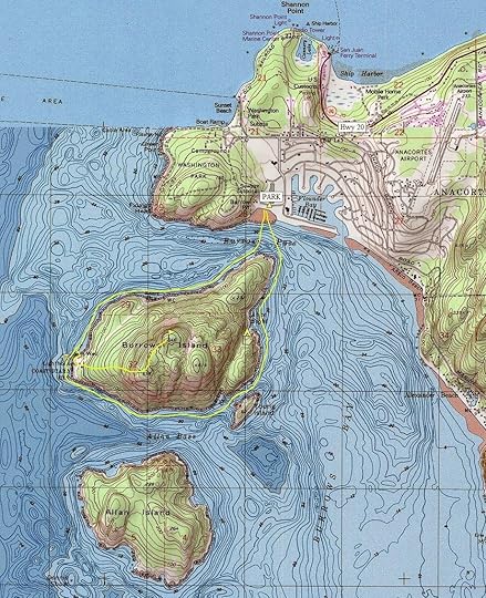
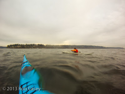
Trip #29 is Burrows Island. One of my favorite paddles in north Puget Sound. I teach at Deception Pass so much I never have time to go elsewhere but Burrows allows me to do a quick trip after some classes.
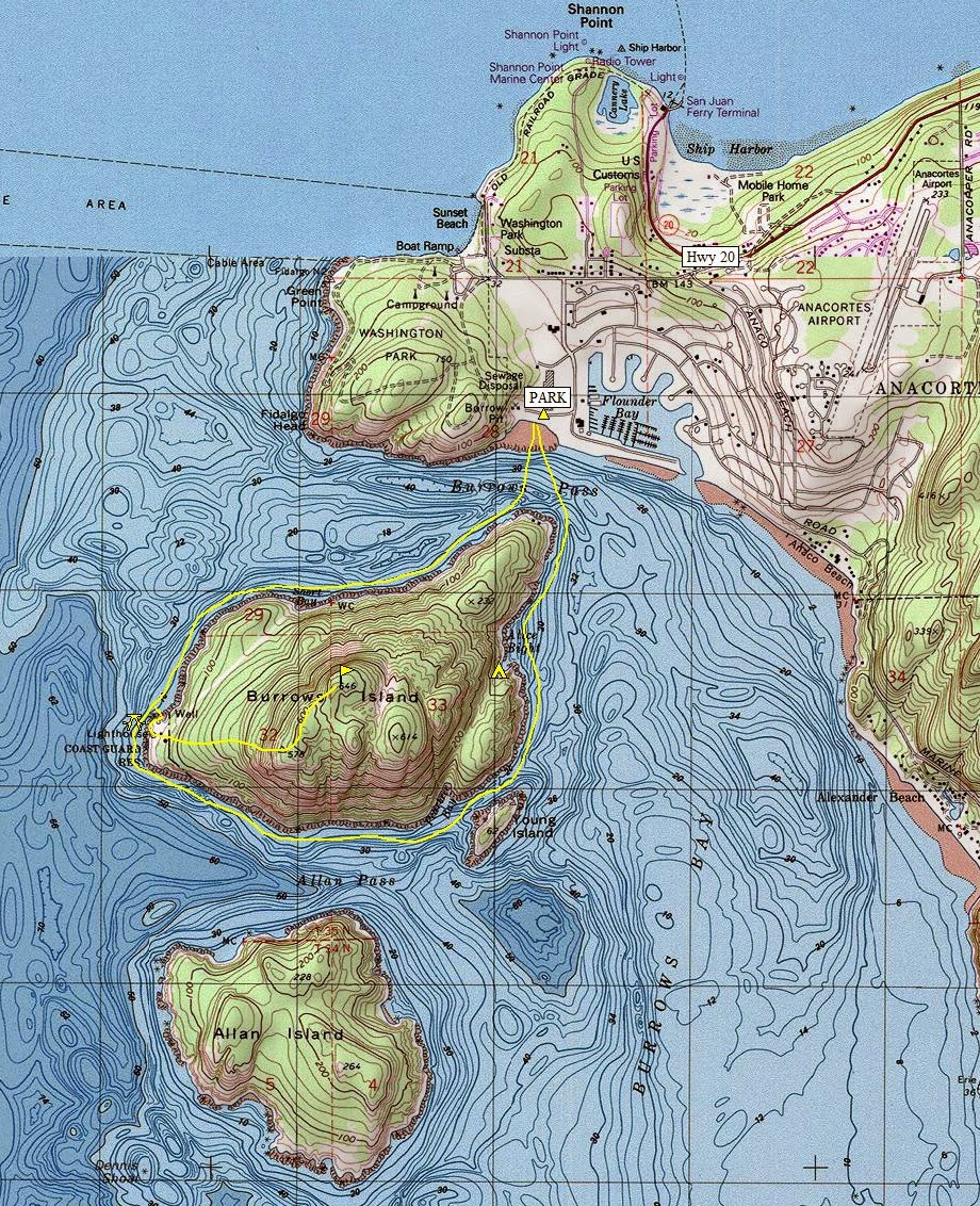
From the Skyline Marina in Anacortes, the crossing to Burrows is about ten minutes, sometimes less. Currents do rip in Burrows Pass separates the island from Fidalgo Island (Anacortes). Note that the flood goes east in Burrows Pass and is stronger than the ebb. I've seen it rip with whitewater mostly on NE tip of the island. There's big eddies to the west of the island, so if you get pushed around there's room for error. Standing waves are possible as well off the point. Watch out for fast speed boats heading to the marina many of which kick off big (waist high?) waves which get bigger in opposing current.
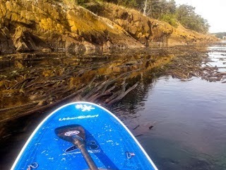
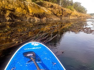
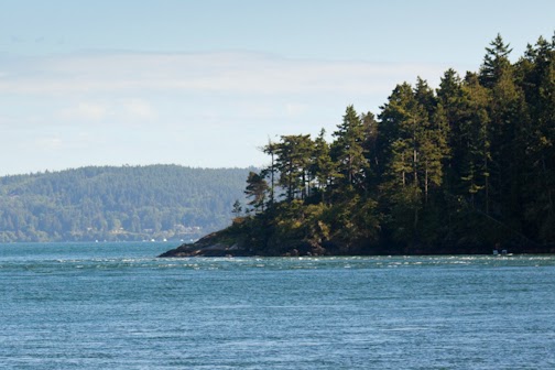
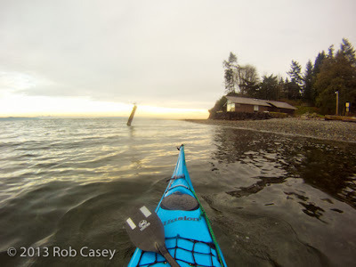
Once across, I tend to paddle along the east shore through thick kelp beds to Alice Bight. The Cascadia Marine Trail has a great campsite in the Bight. Views of the island at this point looks like SE Alaska but looking east you see the developed neighborhoods of Anacortes. The outhouse at the campsite is one of the more luxurious ones in the region, reminding me of the solar composting outhouses in BC.
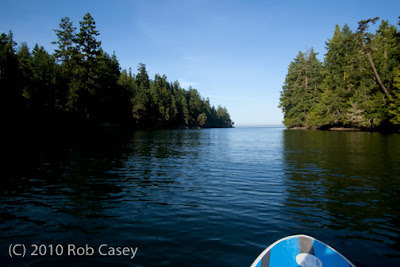
Total circumnavigation of the island can take over an hour if you don't stop using the numerous eddies for protection from current of wind. There's hiking on the island which has a great lighthouse on the west side.
This view from just north of Alice Bight. Park west of Skyline Marina along the road or in the pay dirt lot.
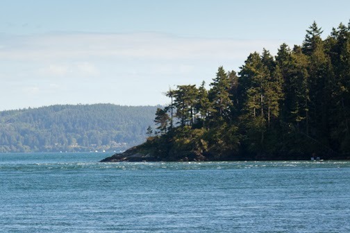 Tide Rip off Burrow's NE corner across from marina.

From the Skyline Marina in Anacortes, the crossing to Burrows is about ten minutes, sometimes less. Currents do rip in Burrows Pass separates the island from Fidalgo Island (Anacortes). Note that the flood goes east in Burrows Pass and is stronger than the ebb. I've seen it rip with whitewater mostly on NE tip of the island. There's big eddies to the west of the island, so if you get pushed around there's room for error. Standing waves are possible as well off the point. Watch out for fast speed boats heading to the marina many of which kick off big (waist high?) waves which get bigger in opposing current.
Once across, I tend to paddle along the east shore through thick kelp beds to Alice Bight. The Cascadia Marine Trail has a great campsite in the Bight. Views of the island at this point looks like SE Alaska but looking east you see the developed neighborhoods of Anacortes. The outhouse at the campsite is one of the more luxurious ones in the region, reminding me of the solar composting outhouses in BC.
Total circumnavigation of the island can take over an hour if you don't stop using the numerous eddies for protection from current of wind. There's hiking on the island which has a great lighthouse on the west side.
This view from just north of Alice Bight. Park west of Skyline Marina along the road or in the pay dirt lot.
 Tide Rip off Burrow's NE corner across from marina.


December 19, 2013
Mats Mats Bay, Trip #33
If you're looking for a mellow bay to paddle in with minimal development for all skill levels, Mats Mats bay is one of my favorites. Located a few minutes north of Port Ludlow and a few miles south of Marrowstone Island, Mats Mats is very protected but has additional options for those seeking more exploring.
Launch directly into the bay on Vernon Road off Paradise Bay Road. Lots of parking and great for big groups. The bay's opening into the Puget Sound is very narrow (for rec boaters) but ideal for paddlers. Once into the Sound, heading right or south will take you to a series of rocks with a great harbor seal population. To the left takes you north past beach homes. Views to the south include Foulweather Bluff on the Kitsap Peninsula, to the east Whidbey Island and to north Marrowstone Island. Mats Mats is Trip #33 in the book.
Tip: Paradise Bay Road is a quick and scenic route connecting Hood Canal Bridge with Port Hadlock. I prefer it to Hwy 104 or Chimacum Road.
 Overview from Paradise Bay Road.
 Entry connecting Mats Mats to the Sound
December 7, 2013
Port Townsend Boat Haven, Trip #36
 Driving into Port Townsend, the first thing you see below the hill is an expansive PT Boat Haven to your right. Boats of all kinds and sizes of all varying conditions are being restored. The town is also home to the Northwest School of Boat Building and the PT Maritime Center has a new building at the end of Water Street. I gave a talk for my SUP book there a year ago as part of their Wednesday speaker series in the Chandry.
 The Boat Haven is worth taking a peek exploring the winding road taking you past all types of boat facilities and shops passing Port Townsend Brewing and the Pourhouse (like beer?). Friend Tim Nolan's shop near the Pourhouse designs commercial watercraft such as the Port Angeles pilot boats. Tim's a local SUP paddler who was instramental in developing the use of the CNC machine for boat building.
Want to launch your boat/board? Find Haines Street in the Boat Haven for a nice sandy beach launch. Plenty of parking, open all the time. In the book, Trip #36.

December 6, 2013
Coastal Defense on Puget Sound
In the late 70's I was a student at Marrowstone Music Camp then located at Fort Flagler on Marrowstone Island. Since it was summer, playing my cello all day didn't necessarily appeal to me, so my friends and I and others snuck away to hide from our instructors in the park's numerous World War 1 era coastal defense bunkers. We knew where every searchlight bunker, observatory pillbox and gun battery was. There were even rumors of a closed tunnel that extended across the park, which in years since we found didn't exist. At the time the park was in poor condition and most of the emplacements were overgrown yet open entirely, whereas since many doorways, slits, and ladder entries have been welded shut.
This introduction led me in my youth to an interest in local coastal defense emplacements. I researched and old blueprints dating to the late 1890's and locations of most of the emplacements throughout Puget Sound, the Strait of Juan de Fuca and near Cape Flattery.
 Above Elwha River mouth.The first emplacement was Civil War era and located next to the Cape Disappointment Lighthouse on the Columbia River mouth. The next series were constructed for the Spanish American War in 1898. These includes the extensive forts in Puget Sound such a Fort Flagler, Worden, Casey, and a few on Rich Passage. There's even a gun battery on Goat Island near La Connor. The final stage was built to keep the Japansese away during World War 2. In all the above cases, history progressed to where each were outdated soon after their completion. The 18" wide diameter muzzle cannon at Salt Creek Rec Area west of Port Angeles was fired only once, then was scrapped.
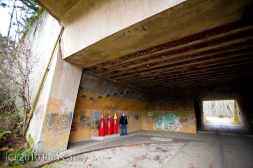
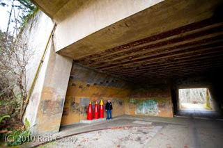
 Fort Casey St Park, Whidbey Island.Not all are mapped or easily found. There's several observatory pill boxes along the length of the Strait of Juan de Fuca. Kayakers have found a mysterious iron door attached to a rock face west of Agate Point (Crescent Beach). Our favorite emplacement, Battery Lee at Fort Flagler is falling off the cliff just above the Marrowstone Ligthhouse. Much of it's lower searchlight rooms are on the beach. The bunker was three levels with ladders going through vertical tunnels to each level. Perfect for hiding from music instructors!
 Salt Creek Rec Area. WW2 Era.
 Fort Casey, Whidbey Island.
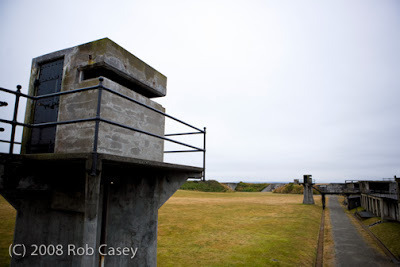
 Fort Ebey, Whidbey island.

This introduction led me in my youth to an interest in local coastal defense emplacements. I researched and old blueprints dating to the late 1890's and locations of most of the emplacements throughout Puget Sound, the Strait of Juan de Fuca and near Cape Flattery.
 Above Elwha River mouth.The first emplacement was Civil War era and located next to the Cape Disappointment Lighthouse on the Columbia River mouth. The next series were constructed for the Spanish American War in 1898. These includes the extensive forts in Puget Sound such a Fort Flagler, Worden, Casey, and a few on Rich Passage. There's even a gun battery on Goat Island near La Connor. The final stage was built to keep the Japansese away during World War 2. In all the above cases, history progressed to where each were outdated soon after their completion. The 18" wide diameter muzzle cannon at Salt Creek Rec Area west of Port Angeles was fired only once, then was scrapped.
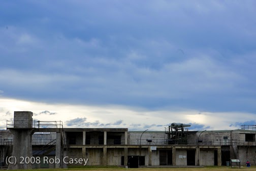 Fort Casey St Park, Whidbey Island.Not all are mapped or easily found. There's several observatory pill boxes along the length of the Strait of Juan de Fuca. Kayakers have found a mysterious iron door attached to a rock face west of Agate Point (Crescent Beach). Our favorite emplacement, Battery Lee at Fort Flagler is falling off the cliff just above the Marrowstone Ligthhouse. Much of it's lower searchlight rooms are on the beach. The bunker was three levels with ladders going through vertical tunnels to each level. Perfect for hiding from music instructors!
 Salt Creek Rec Area. WW2 Era.
 Fort Casey, Whidbey Island.
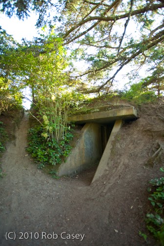 Fort Ebey, Whidbey island.
Coastal Defense on Puget Sound & Beyond
In the late 70's I was a student at Marrowstone Music Camp then located at Fort Flagler on Marrowstone Island. Since it was summer, playing my cello all day didn't necessarily appeal to me, so my friends and I and others snuck away to hide from our instructors in the park's numerous World War 1 era coastal defense bunkers. We knew where every searchlight bunker, observatory pillbox and gun battery was. There were even rumors of a closed tunnel that extended across the park, which in years since we found didn't exist. At the time the park was in poor condition and most of the emplacements were overgrown yet open entirely, whereas since many doorways, slits, and ladder entries have been welded shut.
This introduction led me in my youth to an interest in local coastal defense emplacements. I researched and old blueprints dating to the late 1890's and locations of most of the emplacements throughout Puget Sound, the Strait of Juan de Fuca and near Cape Flattery.
Above Elwha River mouth.The first emplacement was Civil War era and located next to the Cape Disappointment Lighthouse on the Columbia River mouth. The next series were constructed for the Spanish American War in 1898. These includes the extensive forts in Puget Sound such a Fort Flagler, Worden, Casey, and a few on Rich Passage. There's even a gun battery on Goat Island near La Connor. The final stage was built to keep the Japansese away during World War 2. In all the above cases, history progressed to where each were outdated soon after their completion. The 18" wide diameter muzzle cannon at Salt Creek Rec Area west of Port Angeles was fired only once, then was scrapped.
Fort Casey St Park, Whidbey Island.Not all are mapped or easily found. There's several observatory pill boxes along the length of the Strait of Juan de Fuca. Kayakers have found a mysterious iron door attached to a rock face west of Agate Point (Crescent Beach). Our favorite emplacement, Battery Lee at Fort Flagler is falling off the cliff just above the Marrowstone Ligthhouse. Much of it's lower searchlight rooms are on the beach. The bunker was three levels with ladders going through vertical tunnels to each level. Perfect for hiding from music instructors!
 Salt Creek Rec Area. WW2 Era.
This introduction led me in my youth to an interest in local coastal defense emplacements. I researched and old blueprints dating to the late 1890's and locations of most of the emplacements throughout Puget Sound, the Strait of Juan de Fuca and near Cape Flattery.
Above Elwha River mouth.The first emplacement was Civil War era and located next to the Cape Disappointment Lighthouse on the Columbia River mouth. The next series were constructed for the Spanish American War in 1898. These includes the extensive forts in Puget Sound such a Fort Flagler, Worden, Casey, and a few on Rich Passage. There's even a gun battery on Goat Island near La Connor. The final stage was built to keep the Japansese away during World War 2. In all the above cases, history progressed to where each were outdated soon after their completion. The 18" wide diameter muzzle cannon at Salt Creek Rec Area west of Port Angeles was fired only once, then was scrapped.
Fort Casey St Park, Whidbey Island.Not all are mapped or easily found. There's several observatory pill boxes along the length of the Strait of Juan de Fuca. Kayakers have found a mysterious iron door attached to a rock face west of Agate Point (Crescent Beach). Our favorite emplacement, Battery Lee at Fort Flagler is falling off the cliff just above the Marrowstone Ligthhouse. Much of it's lower searchlight rooms are on the beach. The bunker was three levels with ladders going through vertical tunnels to each level. Perfect for hiding from music instructors!
Salt Creek Rec Area. WW2 Era.
December 4, 2013
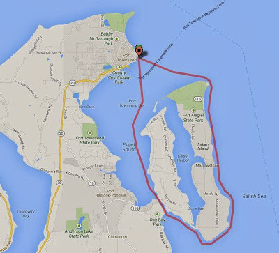
Black Friday Circumnavigation of Indian & Marrowstone Islands
Trip Report from Laura Prendergast of Pygmy Kayaks:
Mission accomplished! Griff and I paddled approximately 19.5 miles (according to google maps) in 6.5 hours around Marrowstone and Indian Island... a great way to spend Black Friday! No lines to buy things... just sea lions eating salmon, curious seals and porpoises surfacing.
Our route was mapped from Pygmy's HQ as I left from the Point Hudson Marina in Port Townsend. We experienced strong currents by the lighthouse on marrowstone. We followed the tide around perfectly, going clockwise with high tide at 12:30.
The route could also be broken into a two day trip using the WWTA Kinney Point campsite on the south end of Marrowstone. www.wwta.org
We were both paddling Pygmy Murrelets 4PD: Greenland Style Touring Kayaks http://www.pygmyboats.com/boats/murrelet-4PD-kayak-kit.html
In the book, Trip 34 & 35.

December 2, 2013
Resources for NW Paddle Trip Planning
General - Covering all aspects of planning:
- Northwest Paddling, http://www.northwestpaddling.net
- My books! This one and my SUP guide, http://www.amazon.com/Rob-Casey/e/B00...
Tidal & Current Predictions:
- NOAA, http://tidesandcurrents.noaa.gov/tide...
- Saltwater Tides, http://www.saltwatertides.com
- Mobile Graphics (type in location), http://tides.mobilegeographics.com/lo...
- http://www.dairiki.org/tides/daily.ph...
- Tides Info, http://www.tides.info
Wind Predictions and Real Time Data:
- Sail Flow, http://www.sailflow.com
- Wind Alert, http://www.windalert.com
- NOAA, http://www.ndbc.noaa.gov/data/Forecas...
Surf Forecasts:
- NOAA, http://www.ndbc.noaa.gov/data/Forecas...
- WA & OR Surf Spots: http://www.surfwater.org
- Storm Surf, http://stormsurf.com
- Magic Seaweed, http://magicseaweed.com
General Weather (non marine):
- Cliff Mass Blog, http://cliffmass.blogspot.com
- National Weather Service (NOAA), http://www.weather.gov
- AccuWeather, http://www.accuweather.com
- Weather.com, http://www.weather.com
Webcams:
- West Point Lighthouse, Seattle: http://www.brichmond.com/webcam/myweb...
- Edmonds, http://www.portofedmonds.org/docs/cam...
- Port Townsend (controllable): http://www.cityofpt.us/webcam.htm
- WA & OR Surf Spots: http://www.surfwater.org
- Big Wave Dave - British Columbia and WA State: http://www.bigwavedave.ca
- WA Dept of Transportation (State Wide): http://www.wsdot.com/traffic/cameras/
Aerial Marine Views of the NW:
- Dept of Ecology, Shoreline Photos, https://fortress.wa.gov/ecy/coastalat...
- Google Earth, http://www.google.com/earth/
- NOAA, http://oceanservice.noaa.gov/geodesy/...
November 29, 2013
Road Ends for Launching into Puget Sound
When updating the 60 Trips book, I found a lot of road ends which appeared to be great places to launch into Puget Sound. Our region has tons of these, many are hard to find or of local knowledge only and some are in obvious places.
Of the two below, the top location in Seattle is 32nd Ave West in the Magnolia neighborhood. It is listed as a hand carry boat launch and is a City of Seattle park. There's no facilities just a lower and upper parking lot. I tend to tread lightly in the lower lot to not take off much space especially when doing a class or tour. Immediately to the right are walk in beach homes, a unique feature for the area. My normal paddle here is to Four Mile Rock about 1 mile west (great freighter waves) or into the Elliott Bay Marina for wind protection if with students.
Link here, http://www.seattle.gov/parks/park_det...
The second location below is on the northwest corner of Bainbridge Island at the end of Agate St NE. Providing great access through a residential neighborhood into the north end of Agate Passage, this one has very limited parking, maybe one car if I recall. Once you arrive on the beach, the beautiful view of Agate Pass and it's bridge are disrupted by No Trespassing signs on both your right and left. While many feel our beaches are public below the high tide line, in truth 60-70 percent of our state's beaches are private. As Mountaineers author Harvey Manning explained in his "Walking the Beach to Bellingham" guide, if you see a beach trespassing sign, most likely it's BS. But check, just in case as it may actually be private. Due to the signs in this image, I chose to not include it in the book, too stressful to put in a public guidebook. You can launch there but go straight out and tread lightly. Right across the waterway is Suquamish's Old Man House park. To the right on the Bainbridge side is a petroglyph on available at low tide.
To get more info on Bainbridge Island's road ends check out these links:
https://www.facebook.com/pages/Bainbr...
http://www.bainbridgeisland.com/thing...
To research Washington State beaches and regulations check out these links:
http://www.ecy.wa.gov/programs/sea/pu...
http://www.coastaltraining-wa.org/Cou...
- Find Public Beaches: https://fortress.wa.gov/ecy/coastalat... (great site!)
- "Walking the Beach to Bellingham", Harvey Manning, Mountaineers Books. http://www.amazon.com/Walking-Beach-B...
 32nd Ave West, Magnolia, Seattle.
 Agate Street N.E., 47.719891,-122.553558 / Bainbridge Island.

Of the two below, the top location in Seattle is 32nd Ave West in the Magnolia neighborhood. It is listed as a hand carry boat launch and is a City of Seattle park. There's no facilities just a lower and upper parking lot. I tend to tread lightly in the lower lot to not take off much space especially when doing a class or tour. Immediately to the right are walk in beach homes, a unique feature for the area. My normal paddle here is to Four Mile Rock about 1 mile west (great freighter waves) or into the Elliott Bay Marina for wind protection if with students.
Link here, http://www.seattle.gov/parks/park_det...
The second location below is on the northwest corner of Bainbridge Island at the end of Agate St NE. Providing great access through a residential neighborhood into the north end of Agate Passage, this one has very limited parking, maybe one car if I recall. Once you arrive on the beach, the beautiful view of Agate Pass and it's bridge are disrupted by No Trespassing signs on both your right and left. While many feel our beaches are public below the high tide line, in truth 60-70 percent of our state's beaches are private. As Mountaineers author Harvey Manning explained in his "Walking the Beach to Bellingham" guide, if you see a beach trespassing sign, most likely it's BS. But check, just in case as it may actually be private. Due to the signs in this image, I chose to not include it in the book, too stressful to put in a public guidebook. You can launch there but go straight out and tread lightly. Right across the waterway is Suquamish's Old Man House park. To the right on the Bainbridge side is a petroglyph on available at low tide.
To get more info on Bainbridge Island's road ends check out these links:
https://www.facebook.com/pages/Bainbr...
http://www.bainbridgeisland.com/thing...
To research Washington State beaches and regulations check out these links:
http://www.ecy.wa.gov/programs/sea/pu...
http://www.coastaltraining-wa.org/Cou...
- Find Public Beaches: https://fortress.wa.gov/ecy/coastalat... (great site!)
- "Walking the Beach to Bellingham", Harvey Manning, Mountaineers Books. http://www.amazon.com/Walking-Beach-B...
 32nd Ave West, Magnolia, Seattle.
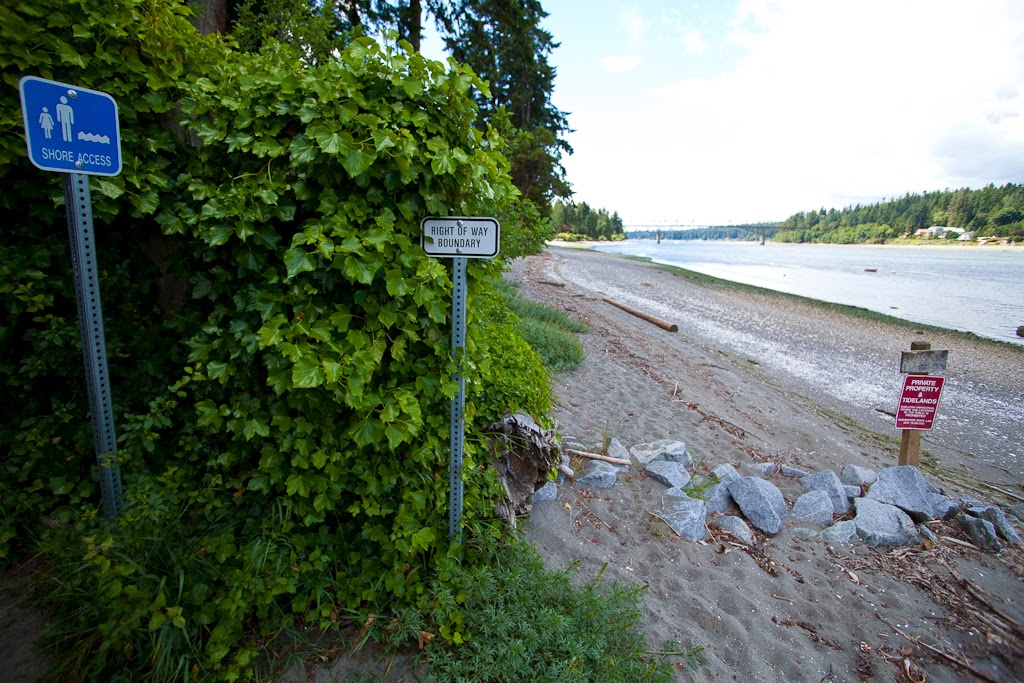 Agate Street N.E., 47.719891,-122.553558 / Bainbridge Island.
November 26, 2013
Puget Sound Crossings
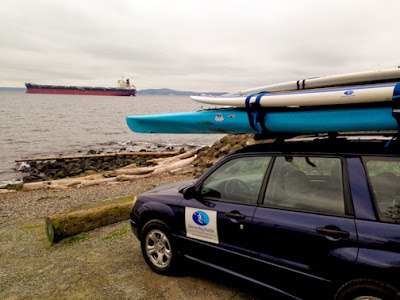
Around 2005ish, neighbor Paul Edmondson called saying he was on Blake Island and out of beer. I poked out the window to make sure he wasn't outside my house as usual. Two hours later I launched at Constellation Park near Alki Beach for my first solo crossing of Puget Sound.
It was late summer, a hot day, and the water was flat calm. Mid way a freighter checked in on the VHF reporting seeing a hundred indian canoes in Admiralty Inlet. I remember thinking how cool! The canoes were from the annual Tribal Journeys trip probably headed to a nearby landing. I made the 4 mile crossing in about 2 hours landing on Blake with fresh beer for Paul (and myself).
I had since made that trip several times, including doing it twice from Ballard to Blake to cut out the Alki commute from our neighborhood of Ballard.
Today neighbor Todd Switzer called "Wanna do a quick trip to Bainbridge?" A frequent kayak fisherman, he's been longing for a longer trip and more exercise. 45 minutes later, we launched from the Elks Beach in Ballard. We stopped at West Point to add on a few layers as the wind was picking up. We crossed to Skiff Point on Bainbridge within an hour, took a few pics, then headed back. Aided by current and a S wind both directions, we made the entire trip in 2.5hrs.
In all my paddling on Shilshole Bay, I hadn't crossed directly to Bainbridge. It was easier than I thought and will be doing it again soon, hoping to explore the shoreline more once on the other side.
 1 mile to Bainbridge.
 Nearing shore.
 Skiff Point. Looks like a great point break for waves.

It was late summer, a hot day, and the water was flat calm. Mid way a freighter checked in on the VHF reporting seeing a hundred indian canoes in Admiralty Inlet. I remember thinking how cool! The canoes were from the annual Tribal Journeys trip probably headed to a nearby landing. I made the 4 mile crossing in about 2 hours landing on Blake with fresh beer for Paul (and myself).
I had since made that trip several times, including doing it twice from Ballard to Blake to cut out the Alki commute from our neighborhood of Ballard.
Today neighbor Todd Switzer called "Wanna do a quick trip to Bainbridge?" A frequent kayak fisherman, he's been longing for a longer trip and more exercise. 45 minutes later, we launched from the Elks Beach in Ballard. We stopped at West Point to add on a few layers as the wind was picking up. We crossed to Skiff Point on Bainbridge within an hour, took a few pics, then headed back. Aided by current and a S wind both directions, we made the entire trip in 2.5hrs.
In all my paddling on Shilshole Bay, I hadn't crossed directly to Bainbridge. It was easier than I thought and will be doing it again soon, hoping to explore the shoreline more once on the other side.
 1 mile to Bainbridge.
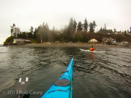 Nearing shore.
  Skiff Point. Looks like a great point break for waves.
November 11, 2013
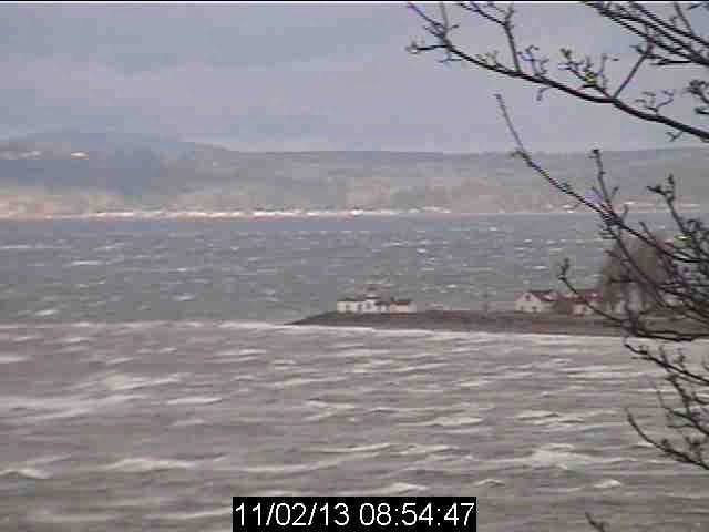
High Wind Day 11/3/13
46kts of wind in Seattle on Nov 3, brought many experienced paddlers out to test their skills while downwinding Puget Sound. 9 outriggers launched from Golden Gardens while an hour later 6 of the region's top SUP'ers launced from the Elks Beach to the south. All were headed to Edmonds or Richmond Beach. The wind turned 180 degrees from southwest to north for each group half way to their destinations. The outriggers finished their run against the wind while the SUPs, not as far along turned it around to paddle back to the Elks.
Below are two fun shots showing the effects of the wind. The top is surfing somewhere near Alki, the second a webcam shot of West Point at the peak of the storm.
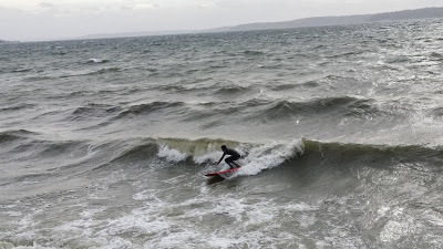


Below are two fun shots showing the effects of the wind. The top is surfing somewhere near Alki, the second a webcam shot of West Point at the peak of the storm.

Rob Casey's Blog

Rob Casey isn't a Goodreads Author
(yet),
but they
do have a blog,
so here are some recent posts imported from
their feed.

