
Rob Casey's Blog, page 12
February 8, 2012
Find NOAA Nautical Charts Online
If you're seeking charts for trips, check out NOAA's online site for a quick peek and/or to download.
Check it out.. http://www.nauticalcharts.noaa.gov/mcd/OnLineViewer.html

Check it out.. http://www.nauticalcharts.noaa.gov/mcd/OnLineViewer.html


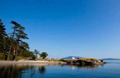
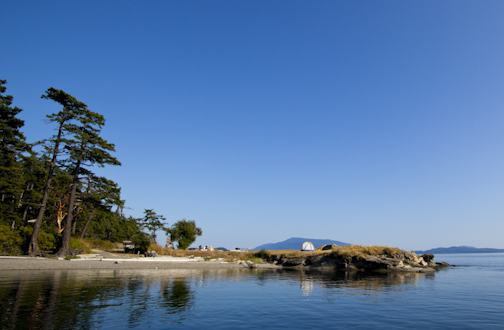
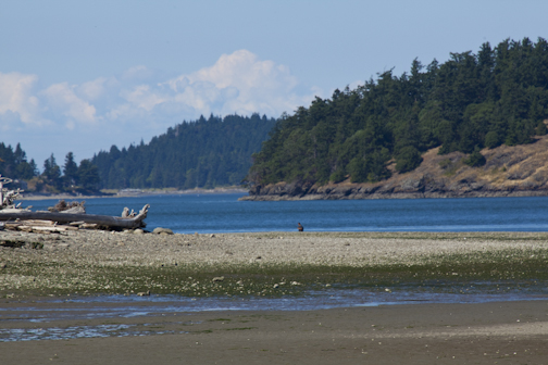
Trip #50 - Patos Island
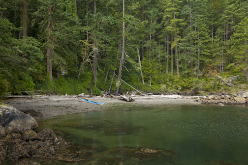
Located a little over 4 miles from the north tip of Orcas Island, Patos Island offers the boater or paddler relative solitude, epic views, a protected gunkhole, and curvy sandstone rock formations. The paddle from Orcas to Patos can be easy if the wind and currents coorperate, or rather hardcore if not. Definitely a trip for experienced paddlers. We rated it 'Exposed' given the remoteness of the island and the potential difficulty to get there.
From Saturna Island in the BC Gulf Islands, the crossing is only 2.7 miles but that's through Haro Strait which can also be easy, or not due to fast moving current squeezing between the islands.
Despite the feeling of solitude from this image, in the height of summer on a weekend there were 8 or so boats moored in tiny Active Cove. The tent on the point was huge, could probably hold up to 7 and behind it tons of camping and food supplies scattered on the grassy point out of view.
Satellite View of Patos, Here.
February 7, 2012
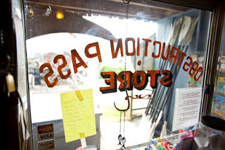
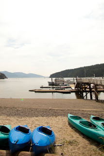
Trip #44 - Obstruction Pass
Obstruction Pass (and island) are located between Orcas Island and Blakely Island. Sometimes swift current flows on both sides of the island giving you an easy free ride or if you time the currents poorly, a long hard slog to your destination.
Obstruction Pass Recreational site, (a former State Park) is located on the southern tip of Orcas Island and has a Cascadia Marine Trail site. Obstruction Pass has several access points from Doe Bay to the north, a public boat ramp across from the island on Orcas, and to the south, Lopez Island.
The following are images of the Leiber Haven Resort on Orcas which is adjacent to the public boat ramp.

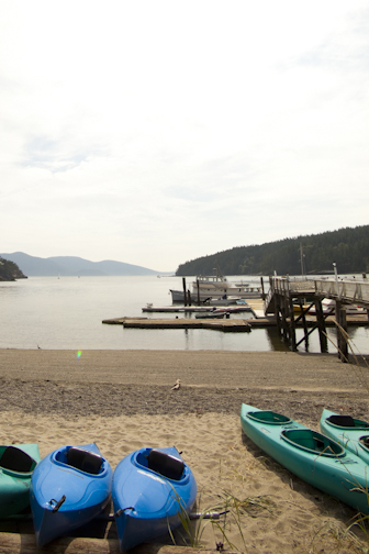
Surf in the San Juans?
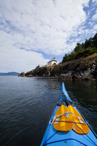
For years, I've heard for San Juan Island locals talk of catching surf off the islands' southern sections. I've spoken to two longboarders and one surf kayaker who have confirmed this. Last summer a prone paddler boarder friend said he caught a really long ride on a waist high wave in False Bay. And it's not surprising given it's location near the eastern opening of the Strait of Juan de Fuca which also delivers surfable swells to the west side of Whidbey Island. For those not familiar with NW surfing, the shorelines along both the Canadian and US side of the Strait have been popular surfing spots for years. For locals, waves must be a relief as getting to traditional surfing areas in BC or WA from the island is quite the trek. San Juan Island is Trip #52 in the book.
The image below is from the SW tip of San Juan Island in September.
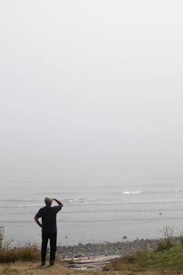


The image below is from the SW tip of San Juan Island in September.

January 30, 2012
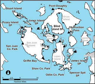
Washington Water Trails Association - WWTA
Since 1990, the Washington Water Trails Association has been helping secure public access and human powered watercraft campsites throughout Puget Sound, Willapa Bay, the Columbia River, the Snake River, and the lakes bordering Seattle.
Trails include:
- Cascadia Marine Trail.
- Lakes-To-Locks Water Trail.
- Willapa Bay Trail.
- Lower Columbia River Water Trail.
- Northwest Discovery Water Trail.
The Cascadia Marine Trail, one of the more popular water trails of the WWTA includes over 140 miles of water from Olympia to the Canadian boarder. By becoming a member (starts at $35 a year), you can have access to their online maps, travel info and details regarding each site. Below is a the page for the San Juan Islands. The triangles are the WWTA campsites for the region.
San Juan Islands:
http://www.wwta.org/trails/CMT/campsites/san_juans/

January 29, 2012
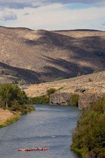
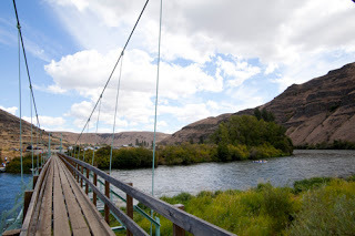
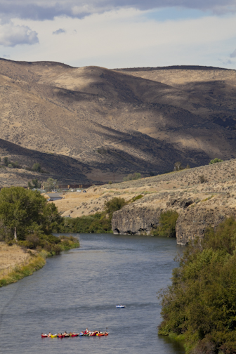
Yakima River Canyon
Yakima River Canyon is one of Wa State's most scenic river paddles and is great for all skill levels. A 1.5 hour drive east of Seattle and located directly south of Ellensburg on Highway 821 (Canyon Road), the river can be easily accessed from I-90. Driving south of the interstate, you begin to drop into the canyon within a few miles. Immediately you will enjoy it's steep grassy hillsides and winding two lane route which parallels the river. The river is also known as a 'Blue Ribbon' fly fishing and catch and release only river. Drift boats are common as are fishermen along it's bushy shores. Red's Fly Shop is located in the canyon and can assist with any fishing questions.
The best guidebook for the trip is "PaddlingWashington: 100 Flatwater and Whitewater Routes in Wahsington State and the Inland Northwest," by Rich Landers and Dan Hansen and published by Mountaineers Books. Click HERE for ordering info.
The canyon route is a Class 1 section of the river, meaning it moves but has few rapids and small riffles to worry about and thus doesn't require much or any river experience. That said, always wear a lifejacket and appropiate immersion clothing for the water and air temperature. The river is very popular in summer with rafters. I'm hoping to try it this year on a SUP with rubber fins.
Details from the book:- Distance: 19 miles- Time: 6 hours.- Season: Year Around (note early summer flows can be swift).- Shuttle: 20 miles, pavement.- Class 1+.- Hazards: Heavy wind, strainers, scattered rapids.- Info: BLM in Spokane.- Maps: USGS Ellensburg South, Kittitas, Wymer- Put In: Ringer, 2.5 miles below I-90.- Take-out: BLM Roza Recreation Area.- Camping: Several spots along the river, mostly BLM land.- More Info & Contact #'s: Public Lands.- BLM Site & Map of Area: HERE.
Learn more about river paddling from local author, Jeff Bennett. His book "The Essential Whitewater Kayaker" by McGraw hill is a good one. My SUP book also has a solid chapter dedicated to river paddling.

January 27, 2012
Trip #27 Hope and Skagit Islands
Only 1.5 hours north of Seattle Hope (North) and Skagit Islands provide easy paddling access and the feeling of being much further away. Both of the undeveloped islands are small, uncrowded, and have multiple access points from 6 different launches. The Cascadia Marine Trail has a cozy campsite on Skagit's northeast side overlooking tiny Kiket Island. During strong tidal exchanges a small tidal rapid rips between both islands which at night can be a pleasant sound. The site is on top of a ancient shell midden, one of few still left in the region. Note: Hope Island (south) is near Olympia, Trip #5.
Currents also rush in between Hope Island and Ala Spit on Whidbey Island. Friends have experienced waves there from the wind opposing the swift current. Time your travel with the currents, and you can have a fun ride through each of these rapids.
Launches:
- Deception Pass State Park - Bowman Bay.
- Deception Pass State Park - Cornet Bay.
- Ala Spit, NE Whidbey Island. (Cascadia Marine Trail campsite)
- Snee-oosh Beach (west of La Connor).
- La Connor.
- Mike's Beach Resort (Rawlins Road south of La Connor).
You'll experience the most current approaching from Deception Pass or Cornet Bay. Time the currents for the flood and flow through the Pass or east of Cornet for a free ride nearly to the islands. Ala Spit is the easiest access to Hope, with only a few hundred yard crossing to the island. There's a Cascadia Marine Trail campsite (pictured) on Ala Spit.
Get more info from the Washington Water Trails Association's Cascadia Marine Water Trail - HERE.
Ala Spit WWTA Campsite View South

Looking north from Ala Spit to Hope Island.
Packing on Skagit Is looking East to Kliket Island.


Currents also rush in between Hope Island and Ala Spit on Whidbey Island. Friends have experienced waves there from the wind opposing the swift current. Time your travel with the currents, and you can have a fun ride through each of these rapids.
Launches:
- Deception Pass State Park - Bowman Bay.
- Deception Pass State Park - Cornet Bay.
- Ala Spit, NE Whidbey Island. (Cascadia Marine Trail campsite)
- Snee-oosh Beach (west of La Connor).
- La Connor.
- Mike's Beach Resort (Rawlins Road south of La Connor).
You'll experience the most current approaching from Deception Pass or Cornet Bay. Time the currents for the flood and flow through the Pass or east of Cornet for a free ride nearly to the islands. Ala Spit is the easiest access to Hope, with only a few hundred yard crossing to the island. There's a Cascadia Marine Trail campsite (pictured) on Ala Spit.
Get more info from the Washington Water Trails Association's Cascadia Marine Water Trail - HERE.

Ala Spit WWTA Campsite View South
Looking north from Ala Spit to Hope Island.
Packing on Skagit Is looking East to Kliket Island.
January 24, 2012
Walking Your Kayak, Canoe, or SUP on the WA or BC Ferries
In the first editions of this book, Randel Washburne wrote of walking his kayak on the ferry for a few trips. In updating the book, I found this is still possible on Washington State Ferries and BC Ferries and costs the same fee as a motorcycle. The passenger only ferries will not take kayaks unless they can be stowed away as an inflatable. Some routes such as the San Juans are free on the way back so many paddle there from the mainland, then ride free back home.
WA State ferries ask you to follow these simple rules:- Arrive one hour early. Consider an earlier arrive during peak summer periods. - Move to the front of the line and wait with the motorcycles and bicyclers.- Use a cart to more efficiently carry your kayak and gear.- Have your kayak ready to board the ferry efficiently without any issues.- You will be the first off, so be ready when the ferry lands.
Several ferry landings have public access adjacent docks or easily accessed beaches. Others require walking your kayak a short distance to the water. Make sure to scout or confirm your launch prior to departure as things change and public access is becoming harder to come by.
Nadja Baker and her husband wheel their kayak to the shore a few blocks from their house in Anacortes. They paddle to several destinations from there but carry wheels in case poor weather changes their plans and requires a ferry ride back home.
Consider using a wheel or cart system that can be broken down and placed in a hatch or on your deck. SUPs have several innovative wheel systems, see my Stoke Magazine blog posting on this topic: http://stokemagazine.blogspot.com/2012/01/10-wheels-for-sups.html
Also confirm overnight parking info at your ferry departure location. Some require fees and a Discovery Pass for State Parks. Downtown Seattle used to have parking in lots across from Alaskan Way. But the tunnel construction and demise of the viaduct will change this, thus we didn't list it in the book.
Here's a short list of ferry landings which have easy access launches:- Kingston. Launch below the short flight of stairs on the north side of the parking lot. Or wheel your boat through past the terminal restrooms to launch in the marina in the bay adjacent to the dock.
- Edmonds. Wheel your boat down the dock and exit on the left or north side into the public beach park.
- Southworth. Wheel your boat up the slight hill about 300 yards, then take a hard near 180 degree right to follow the single lane paved road which parallels the ferry dock to the north. There's a nice sandy beach at the end right next to the ferry.
- Vashon. Access the beach below the Mexican restraunt on the left or east side of the dock.
- Mukilteo. There's a small beach park on the east or right side of the dock with parking if needed.
- Keystone. Wheel your boat to the right off the dock and into the gravel public boat ramp lot. Launch into the protected bay adjacent to the ferry.
- Port Angeles (Blackball Ferry). Wheel your boat about a half block left or east of the dock at Hollywood Beach adjacent to the Red Lion Inn. The restraunt there has a good salmon dinner.
- Lummi Island.From the mainland use the public lot behind the store adjacent or north of the dock. Bring cash for the ferry (no cards accepted).
- Bainbridge.Wheel your boat up the dock past the toll booths. Aim towards the left side of the road and at the top of the hill, approx 400yds, take a left at the Eagle Harbor Condos. At the bottom of the hill before the condos take the footpath to the beach, approx 300yds.
Useful Links:
WA State Ferries: http://www.wsdot.wa.gov/ferries/
BC Ferries: http://www.bcferries.com/
Kayak Wheel Systems:
- NW Outdoor Center, https://www.nwoc.com/shop/category.asp?catid=22
- Kayak Academy, http://tinyurl.com/6qp7668
SUP Wheel Systems:
- See My SUP Blog - Stoke Magazine.
January 22, 2012
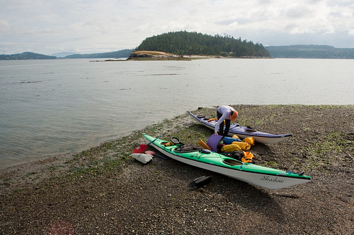
Trip # 29 - Burrows Island
Located a short distance off Fidalgo Island and city of Anacortes, Burrows offers a quick wilderness escape. From Skyline Marina at Anacortes, the paddle is about 5 minutes to the undeveloped island. Many also appoach Burrows as a stopping off point when paddling between Anacortes and Deception Pass.
On the eastern shore, there's a Cascadia Marine Water Trail site with one of the best outhouses around. The campsite is perched 20 feet above the little protected cove well protected from southerly and northerly winds. A lighthouse is on the western shore above the water on a rocky cliff. You can land there in the rocky nook on the north side of the lighthouse.
Currents at Burrows are quite strong and friends have spoken of a standing wave on the southern shore in certain conditions. Private Allen Island borders Burrows on it's south side. Circumnavigating Burrows can take about 1.5hrs if you're in a hurry or longer, which recommended. The island's rocky shores and madrona and fir lined forests make it a very scenic paddle or stopover.
Make sure to check the current table for the area prior to launching. Wind can funnel through both the north and south sides of the island. Wind vs current can create route conditions.
Street park is available by Skyline Marina and in the dirt pay lot by the water.
Washington Water Trails link to Burrows for more info, HERE.
Alice Bight, location of the WWTA campsite.
West side of island.
January 10, 2012
Trip #11 - Maury Island - Vashon
There's few places in Puget Sound where you can portage across an island. On Vashon Island, you have the opportunity to do this whether it's to escape rough waters for calm, access other parts of the island, or get to other destinations nearby without having to paddle all the way around the island.
Native peoples used Vashon's portage to save time in travelling throughout Puget Sound and by Captain Vancouver's accounts, used the narrow strip to funnel and catch birds using tall poles and nets. This view is from above the tiny town of Dockton on Maury Island, Vashon's southeastern extension.
Trip #11 orginates from Saltwater State Park in Des Moines south of Seattle, and crosses Puget Sound to the Pt Robinson Lighthouse on Maury Island. There are Cascadia Marine Trail campsites at both Saltwater State Park and Pt Robinson.
Vashon's Portage seen from Maury Island.


Native peoples used Vashon's portage to save time in travelling throughout Puget Sound and by Captain Vancouver's accounts, used the narrow strip to funnel and catch birds using tall poles and nets. This view is from above the tiny town of Dockton on Maury Island, Vashon's southeastern extension.
Trip #11 orginates from Saltwater State Park in Des Moines south of Seattle, and crosses Puget Sound to the Pt Robinson Lighthouse on Maury Island. There are Cascadia Marine Trail campsites at both Saltwater State Park and Pt Robinson.

Vashon's Portage seen from Maury Island.
Rob Casey's Blog

Rob Casey isn't a Goodreads Author
(yet),
but they
do have a blog,
so here are some recent posts imported from
their feed.

