
Rob Casey's Blog, page 11
April 13, 2012
60 Trips Book Presentation at the Port Angeles Kayaking Sympoisum 4/14
Join Me for a 60 Trips Presentation at the Port Angeles Kayaking Sympoisum Sat evening, 4/14.
http://www.raftandkayak.com/kayak-symposium/
I'm also teaching basic SUP classes both mornings of April 14 and 15 at the event. Private SUP instruction is available. Contact me for more info on my cel, 206.465.7167.

http://www.raftandkayak.com/kayak-symposium/
I'm also teaching basic SUP classes both mornings of April 14 and 15 at the event. Private SUP instruction is available. Contact me for more info on my cel, 206.465.7167.


March 26, 2012
My Upcoming Talks for 60 Trips Kayaking Puget Sound & the San Juans..
The 60 Trips book launches June 1st, almost there! I'm finishing my last edit of the galleys this week looking for last minute changes, errors, etc. Then it goes off to print.
Here's my schedule of upcoming book talks...(as of 3/26)...
- April 14th, Saturday night presentation, Port Angeles Kayaking Symposium. Click Here for Info .
- May 16th, Port Townsend Wooden Boat Chandlery / Northwest Maritime Center
& Wooden Boat Foundation 12 Noon to 1:30pm.


Here's my schedule of upcoming book talks...(as of 3/26)...
- April 14th, Saturday night presentation, Port Angeles Kayaking Symposium. Click Here for Info .
- May 16th, Port Townsend Wooden Boat Chandlery / Northwest Maritime Center
& Wooden Boat Foundation 12 Noon to 1:30pm.
Trip #12 - Blake Island State Park
Here's an image of mine shot around 2004 at the southern campsite on Blake Island State Park. I discoverd the view on Getty Images over the weekend, orginally shot on film. We most likely paddled in from near Alki, although in later years we found it easier to paddle to Blake from our home in Ballard, approx 8 miles one way. The paddler in view is Todd Switzer. The Cascadia Marine Trail campsite is on the opposite side of the island.


March 12, 2012
Trip #18 - Shilshole Bay
I consider Shilshole Bay my backyard. Only 5 minutes from my house, I can pop down there for a short paddle in the middle of the day and even use it as a launch for longer trips in Puget Sound. I surf freighter and tug wakes there, and equally enjoy the glassy waters of the protected Shilshole Marina.
In winter after several days of rain, the current below the Locks can get up to 4 knots which is a great fitness paddle in going upstream, and a fun free ride to take the current back into the Sound. A few times a year there's a touch of whitewater below the Locks - good for practicing my river skills in light current.
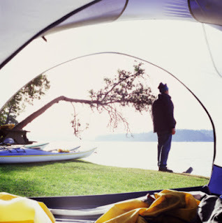
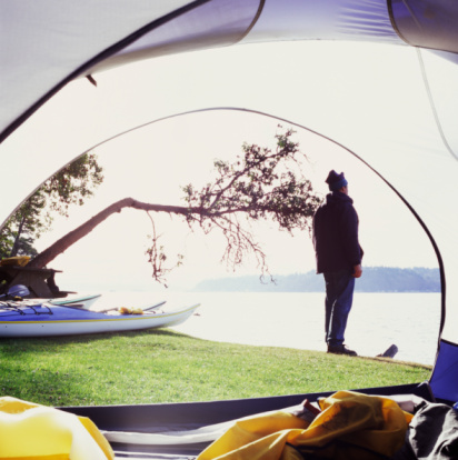
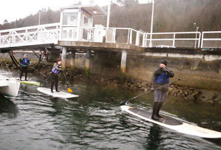
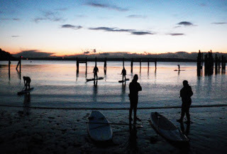
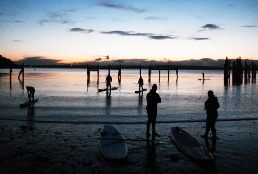
Here's a few images from recent Skills Clinics which I lead through my Stand Up Paddle Seattle Meet Up group. These clinics are held every Monday evening for 2 hours. More info Here.


In winter after several days of rain, the current below the Locks can get up to 4 knots which is a great fitness paddle in going upstream, and a fun free ride to take the current back into the Sound. A few times a year there's a touch of whitewater below the Locks - good for practicing my river skills in light current.
Here's a few images from recent Skills Clinics which I lead through my Stand Up Paddle Seattle Meet Up group. These clinics are held every Monday evening for 2 hours. More info Here.

March 7, 2012
Ebeys Landing, Trip #25
One of the new trips we added to the book is Trip #25 Keystone ferry landing to the Hastie Lake boat ramp on the west side of Whidbey Island. I've hiked sections of this trip for years, paddling it is in itself another experience. Strong currents, tide rips, and exposed wind and surf can make this trip treacherous or fun depending on the skill level of the paddler. Some days the same stretch can be flat as a lake. One of my favorite stretches is by Ebey's Landing, pics below. Amazing views up the Strait, over to Port Townsend and north to the San Juans.
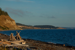
Ebeys Landing looking south to Admiralty Head
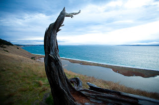
View from the bluff above Ebeys Landing


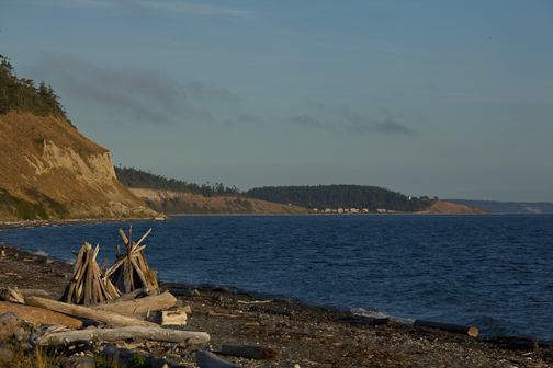
Ebeys Landing looking south to Admiralty Head
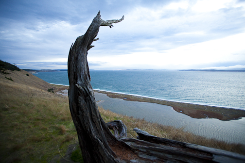
View from the bluff above Ebeys Landing
February 20, 2012
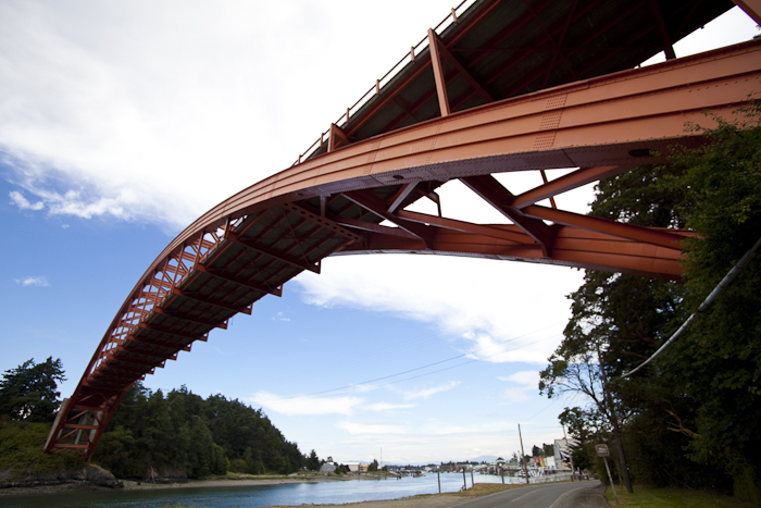
Trip #26 - Skagit River Delta - La Connor
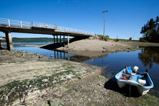
The Skagit River Delta chapter is quite extensive and includes Goat and Ika Islands, La Connor, and several river channels to the south. Here's an image of the Rainbow Bridge in La Connor. There's a new Cascadia Marine Trail campsite just below the bridge on the right (or east) side in Pioneer Park. Also below the bridge is the only easy water access via a boat ramp in La Connor. For more info on the campsite check out www.wwta.org.
La Connor is a great place to grab a bite, a beer, and/or stock up for a trip while in town.
The image below of the wire fish sculpture is in the town of La Connor. We couldn't find any info on whether it's ok to launch there. The current rips through there on big exchanges and it's most often used by commercial fishermen.
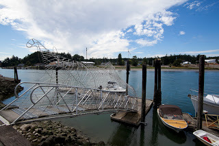
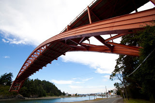

February 17, 2012
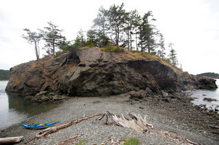
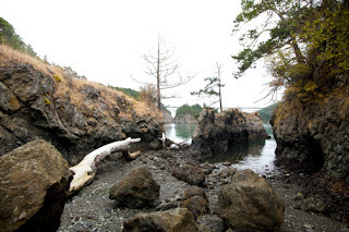
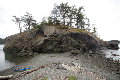
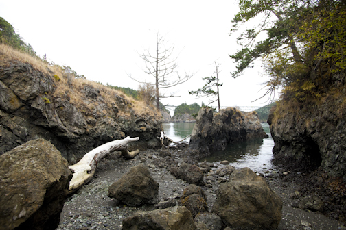
Trip #28 - Deception Pass State Park
Only 1.5 hours from Seattle, Deception Pass State Park is one of my favorite destinations. It's known for it's swift tidal current and rapids which squeeze through a narrow a canyon with an large rock island in the middle. Currents can run up to 8 knots and changes directions a few times a day. River like features such as whirlpools, eddylines, standing waves, and boils draw experienced paddlers, clubs, and kayak schools to the pass to learn and enjoy the water.
DP as we call it, also has varied terrain which can appeal to paddlers of all skill levels. Not far from the fast curent areas are protected coves and bays, pocket beaches, caves, extensive kelp beds, rock formations, and sandy beaches. One can paddle in the park without ever sensing any current or difficult paddlling. I love to take my SUP there and when lucky surf up to 5' standing waves in Canoe Pass on the ebb at lower tides. The waves build when strong NW swell coming in from the Strait of Juan de Fuca collides with the ebb current in the pass.
Most common put-ins are Bowman Bay and Cornet Bay. Both are protected launches each with their own features. Those wanting to travel through the pass or play in the rapids use a Current Table to determine the best time to travel, which launch to use, etc. For example, if the current is flooding (coming in) but will taper off by noon, you'll launch at Bowman Bay, take the flood through the pass and when the current tapers off and begins to ebb (going out) you'd take the current back out towards Bowman Bay.
Terms to know:
Ebb: outgoing current
Flood: incoming current
Slack: period of little or no current in between each cycle. Lasts 5-30 minutes.
Current Tables: Find online or in print in most tide table books. Sample Here.
Tip: If launching from Bowman Bay, portage over the sandy isthmus on the south side of the bay to more easily access the current below Canoe Pass.
Here's a few images from less common perspectives in the pass.
February 16, 2012
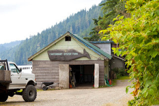
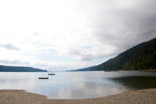
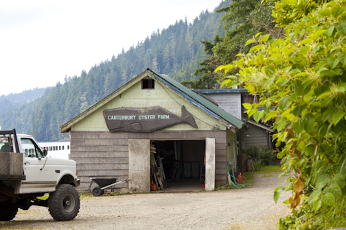
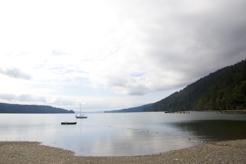
Trip #23 Hood Canal - Quilcene
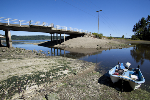
Located within an hour of Seattle, Hood Canal is known for its' oysters, quiet beaches, epic views of the Olympic Mountains, and tiny towns such as Lilliwaup, Brinnon, and Potlatch. Quilcene on the northwest end is tucked inside two bays - Dabob and Quilcene Bays. Most often, the water is calm. Mudflats empty at low tides requiring the paddler to plan their route prior to departure.
From Quilcene, launch from the Herb Beck Marina south of town, or from the Pt Whitney Shellfish Labs beach. The Pt Whitney beach is strewn with oysters. I once saw a guy trying to get in his newly built wood strip kayak in a few feet of water to avoid scratching the hull. Another method is to bring along those foam pool noodles to launch on if this is an issue for you. I'd recommend booties or shoes while walking on the beach.
Beach Launch from the Herb Beck Marina.
February 13, 2012
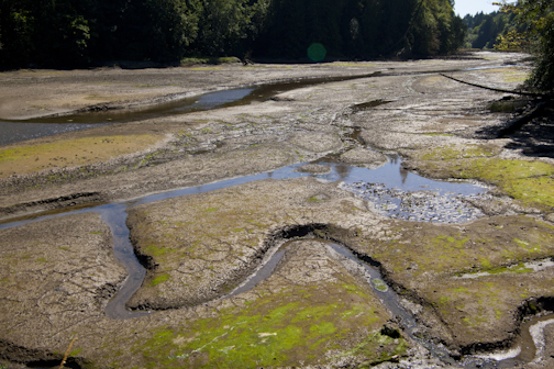
Low Tides & Mudflats of Puget Sound
In a 2/12 posting on my paddling blog Stoke Magazine titled "9 Tips for Paddling Safely wth Tides," I offered tips on how to avoid getting stuck in mudflats on low tides. Below is a list of areas in and around Puget Sound which are worth paying attention to if you're planning on paddling there.
General rule of thumb if planning of paddling in these areas - find out the minimum tide level to safely paddle there and launch on a rising tide.
South Sound -
There are quite a few inlets, bays, and coves here which completely dry out during lower tides. This is only a short list..
- Nisqually Reach / Delta, Trip #4.
- Woodward Bay (inside Henderson Inlet), Trip #3.
- Eld Inlet, Trip #2.
- Kopachuck State Park & Cutts Island, Trip #7.
- Gig Harbor, Trip #9
Mid Sound -
- Eagle Harbor / Bainbridge, Trip #13 & 14.
- Duwamish Waterway, Trip #16.
- Everett Harbor, Trip #21.
- Central Hood Canal, Trip 23 (mostly river mouths - Hamma Hamma, Dosewallips, etc).
North Sound -
- Skagit River Delta, Trip #26.
- Deception Pass State Park, Trip #28 (Cornet Bay, Bowman Bay).
- Chuckanut Bay, Trip #31 (Larabee St Park south.)
- Padilla Bay.
- Warm Beach (between Camano Island and the mainland).
- Lummi Island north to Sandy Point and south near Eliza Island.
Olympic Peninsula -
- Indian Island, Trip #34 (southern section).
- Discovery Bay, (south end).
- Dungeness Spit, Trip #38.
- Sequim Bay, Trip 37, (by casino).
San Juan Islands -
- Lopez Island, Fishermen's Bay, Trip 44.
- Orcas Island, (Eastsound area).
Gulf Islands -
- Sooke Harbor, Trip #54, (inner shorelines).
- Saltspring Island, Ganges Harbor.
- Pender Island, Trip 60 (various coves and inlets).
Other:
- Willapa Bay and eastern and northern Long Beach Peninsula.
- Columbia River from mouth upriver approx 10 miles.
- Grays Harbor.
- mouth of the Physt River inside of Pillar Point on the Strait of Juan de Fuca.
- north of Bellingham near US/CA border.

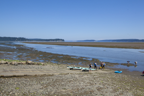
Woodward Bay, South Sound.
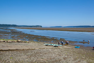
Nisqually Reach, South Sound.


General rule of thumb if planning of paddling in these areas - find out the minimum tide level to safely paddle there and launch on a rising tide.
South Sound -
There are quite a few inlets, bays, and coves here which completely dry out during lower tides. This is only a short list..
- Nisqually Reach / Delta, Trip #4.
- Woodward Bay (inside Henderson Inlet), Trip #3.
- Eld Inlet, Trip #2.
- Kopachuck State Park & Cutts Island, Trip #7.
- Gig Harbor, Trip #9
Mid Sound -
- Eagle Harbor / Bainbridge, Trip #13 & 14.
- Duwamish Waterway, Trip #16.
- Everett Harbor, Trip #21.
- Central Hood Canal, Trip 23 (mostly river mouths - Hamma Hamma, Dosewallips, etc).
North Sound -
- Skagit River Delta, Trip #26.
- Deception Pass State Park, Trip #28 (Cornet Bay, Bowman Bay).
- Chuckanut Bay, Trip #31 (Larabee St Park south.)
- Padilla Bay.
- Warm Beach (between Camano Island and the mainland).
- Lummi Island north to Sandy Point and south near Eliza Island.
Olympic Peninsula -
- Indian Island, Trip #34 (southern section).
- Discovery Bay, (south end).
- Dungeness Spit, Trip #38.
- Sequim Bay, Trip 37, (by casino).
San Juan Islands -
- Lopez Island, Fishermen's Bay, Trip 44.
- Orcas Island, (Eastsound area).
Gulf Islands -
- Sooke Harbor, Trip #54, (inner shorelines).
- Saltspring Island, Ganges Harbor.
- Pender Island, Trip 60 (various coves and inlets).
Other:
- Willapa Bay and eastern and northern Long Beach Peninsula.
- Columbia River from mouth upriver approx 10 miles.
- Grays Harbor.
- mouth of the Physt River inside of Pillar Point on the Strait of Juan de Fuca.
- north of Bellingham near US/CA border.
Woodward Bay, South Sound.
Nisqually Reach, South Sound.
February 11, 2012
Trip #9 Gig Harbor to Olalla
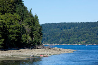
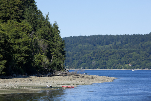
Located on Colvos Passage and the Kitsap Peninsula, Olalla is halfway between Southworth and Gig Harbor. Once known for it's strawberry crop which ripened earlier than other regions on Puget Sound, the 'town' consists of one small convenience store. We passed through here on July 4th 2011 while updating this book and were excited to see the locals sunning on the low tide beaches, fishing, boating, etc. The little inlet which dries out at low tide is also the boat ramp.
Olalla is a little over 6 miles from Gig Harbor to the south, and the same for Southworth to the north. The Current in Colvos Passage runs mostly north, so think of that when planning a trip here.


Olalla is a little over 6 miles from Gig Harbor to the south, and the same for Southworth to the north. The Current in Colvos Passage runs mostly north, so think of that when planning a trip here.
Rob Casey's Blog

Rob Casey isn't a Goodreads Author
(yet),
but they
do have a blog,
so here are some recent posts imported from
their feed.

