
Rob Casey's Blog, page 13
January 3, 2012
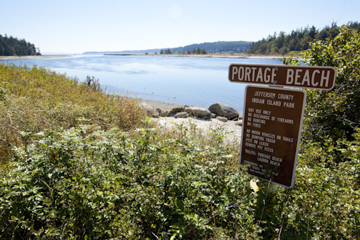
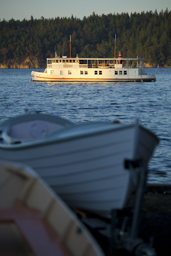
Trip #43 - Indian Island - Portage Beach & Port Hadlock
Trip #43 - Indian Island is one of the most picturesque trips in the book with so many sights in such a short distance. The trip has multiple launches, moving current to protected inlets, two Cascadia Marine Trail campsites, and a hidden Naval base which may or may not have a Nuclear arsenal stored behind it's thick canopy of forest.
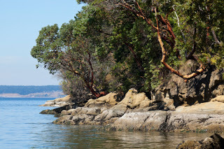
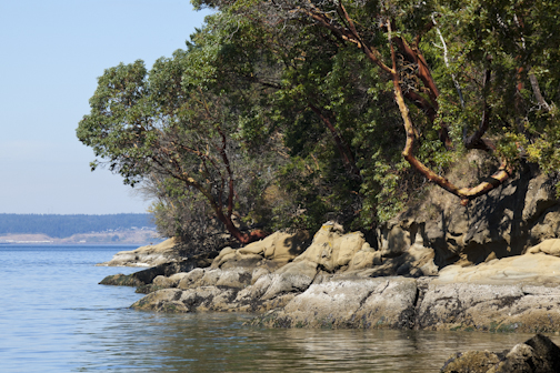
North of the bridge on Indian Island.
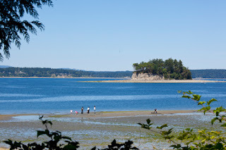
In the old book, Indian and Marrowstone Islands were one trip, but I find this area so interesting that I split them into two trips. Portage Beach is a new wwta site, and we added the Port Hadlock launch which is alongside our favorite restraunt, the Ajax Cafe. Here's a few pics from the Port Townsend Canal side of the island.

South of bridge by WWTA site.
Port Hadlock


North of the bridge on Indian Island.
In the old book, Indian and Marrowstone Islands were one trip, but I find this area so interesting that I split them into two trips. Portage Beach is a new wwta site, and we added the Port Hadlock launch which is alongside our favorite restraunt, the Ajax Cafe. Here's a few pics from the Port Townsend Canal side of the island.
South of bridge by WWTA site.
Port Hadlock


December 30, 2011
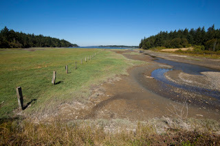
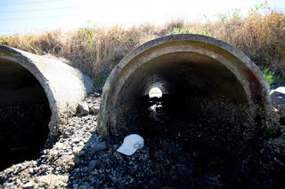
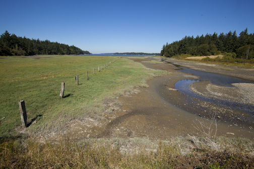
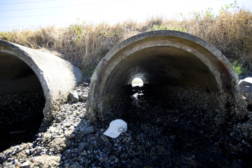
Trip 43 - Indian Island's Causeway
In the first two editions of this book, Trip #43 listed a causeway located under the roadway of the isthmus separating Indian and Marrowstone Islands. It was suggested that with enough water you could get a tidal push through the causeway to each side.
We researched the causeway last summer and found that due to years of barnacle build-up in the pipes, there is no way any paddler could make it through without sraping or bumping their heads while in a prone position. In otherwords, I wouldn't recommend trying - sketchy!
Portaging over the causeway is the best bet. Time the tides so they're high, otherwise you'll have 200-300 yards of sludging through thick mud on both sides. While going over, watch for traffic, local residents drive through this stretch quickly to shorten their commutes from the mainland.
Looking north from causeway.
Looking from north to south.
December 16, 2011
Freshwater Bay to the Elwha River, Trip #40
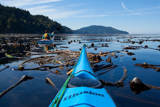
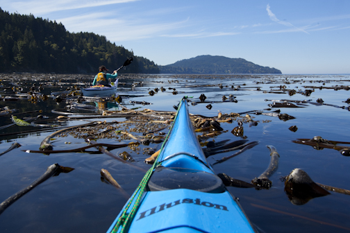
A new trip in the book, I've been paddling from Freshwater Bay (aka FWB) to the Elwha River for a few years. Located along the Strait of Juan de Fuca west of Port Angeles, this trip offers on calm days a beautiful paddle through several miles of kelp beds and undeveloped shoreline. We rated the trip Exposed, as it can also get quite rough mostly towards the Elwha end, so strong paddling experience is required to do the whole trip. The one way distance Freshwater Bay boat ramp to the Elwha River mouth is 4 miles.
Launching at the Freshwater Bay boat ramp, a Clallam County Park, there's plenty of parking for day use only. Paddle east either along the shoreline or 'Bee' line it to the Elwha straight across the bay. If you choosenot to go to the Elwha, the bay provides lots of exploring and can be done so with less experience on mellow days. You'll experience different conditions there - either super mellow or huge seas requring expert paddling skills. The bay can get rough on northerly winds, and I've actually surfed waist high waves at the FWB boat ramp. Friends who guide kayakers through there for Adventures Through Kayaking in Port Angeles, talk of a bay wide gyro or eddy formed off Observatory Point on the west end of the bay from westerly swell or westerly winds. If you feel you're 'bucking' or going against current - adjust your strategy or course direction to get out of the current.
The Elwha River's two dams are currently being removed as part of the largest dam removal project in North America. Many hope the sediment built up behing the dams will flow to the mouth rebuilding it's now rocky beaches. Watch the dam removal process in real time from webcams, Here.
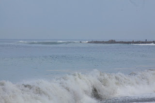
The river's mouth can like FWB be either glassy or quite rough. Surfers who love big hollow fast waves surf here. Waves break in very shallow water as little as 3'. If you wipeout, you're falling on knee high rocks. I've seen 6' faces come out of completely flat water off the mouth - scary! The surfing vibe here can be quite 'local' and rather aggressive, so make sure you know surfer's etiquette and can negotiate large surf in whatever craft you're paddling. A rip can occur off the mouth on the ebb - remember to paddle perpendicular to the current to escape the pull out to the Strait.
On small or now swell days surfers usually aren't present and you can paddle right up the mouth with ease. About an eighth of a mile up stream, you'll encounter a small class 2 rapid which be surfed at higher water levels. Stay off the shore on the east side of the river as it's Lower Klallam Tribal land and is often enforced.
In May, the Da Fuca Downwinder, a 13 mile paddling race goes from the boat ramp at FWB to Port Angeles. Click HERE for race info.
Prior to launching for this trip, check the ocean swell size and direction. Also check wind direction and tides. The Strait winds goes most often East or West, and in winter North or Northwesterly. Large ocean swell can seriously affect your paddle, particuliarly closer to the Elwha. Summer low tides at the FWB boat ramp can mean a long haul to the water. Low tides at the Elwha are great for exploring the gravel river channels at the mouth.
Alternative Trip: #41 FWB to the Salt Creek Rec Area. Exposed.
A few sites to look at to help prepare for your trip:
Surf WA
NOAA La Perouse Buoy at the mouth of the Strait. Check for swell size.
NOAA Marine Forecast for WA State. Check for 'Central Strait' wind conditions.
Surf Etiquette - There's several sites available, here's one to get acquainted with.
Adventures Through Kayaking - This Port Angeles kayaking shop offers tours of FWB.
Getting There: Drive west from Port Angeles on Hwy 101. Take the Hwy 112 junction (at the Junction Roadhouse) right and follow for approx 10 miles. Look for FWB boat ramp signs on your right. Follow FWB road to the shore.
Images below Clockwise: FWB in summer; Elwha River above the mouth; Elwha River at the mouth on a calm day; Elwha River mouth on a rough day seen from FWB.
Freshwater Bay going west.
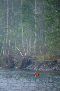
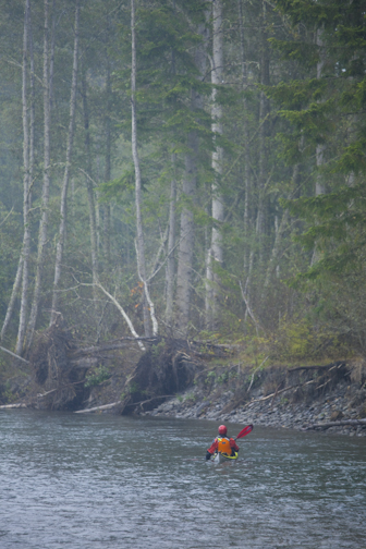
Jory paddling the Elwha.
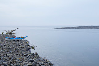
Mouth of the Elwha on a calm day.
Elwha River mouth on a stormy day, looking east.


Launching at the Freshwater Bay boat ramp, a Clallam County Park, there's plenty of parking for day use only. Paddle east either along the shoreline or 'Bee' line it to the Elwha straight across the bay. If you choosenot to go to the Elwha, the bay provides lots of exploring and can be done so with less experience on mellow days. You'll experience different conditions there - either super mellow or huge seas requring expert paddling skills. The bay can get rough on northerly winds, and I've actually surfed waist high waves at the FWB boat ramp. Friends who guide kayakers through there for Adventures Through Kayaking in Port Angeles, talk of a bay wide gyro or eddy formed off Observatory Point on the west end of the bay from westerly swell or westerly winds. If you feel you're 'bucking' or going against current - adjust your strategy or course direction to get out of the current.
The Elwha River's two dams are currently being removed as part of the largest dam removal project in North America. Many hope the sediment built up behing the dams will flow to the mouth rebuilding it's now rocky beaches. Watch the dam removal process in real time from webcams, Here.
The river's mouth can like FWB be either glassy or quite rough. Surfers who love big hollow fast waves surf here. Waves break in very shallow water as little as 3'. If you wipeout, you're falling on knee high rocks. I've seen 6' faces come out of completely flat water off the mouth - scary! The surfing vibe here can be quite 'local' and rather aggressive, so make sure you know surfer's etiquette and can negotiate large surf in whatever craft you're paddling. A rip can occur off the mouth on the ebb - remember to paddle perpendicular to the current to escape the pull out to the Strait.
On small or now swell days surfers usually aren't present and you can paddle right up the mouth with ease. About an eighth of a mile up stream, you'll encounter a small class 2 rapid which be surfed at higher water levels. Stay off the shore on the east side of the river as it's Lower Klallam Tribal land and is often enforced.
In May, the Da Fuca Downwinder, a 13 mile paddling race goes from the boat ramp at FWB to Port Angeles. Click HERE for race info.
Prior to launching for this trip, check the ocean swell size and direction. Also check wind direction and tides. The Strait winds goes most often East or West, and in winter North or Northwesterly. Large ocean swell can seriously affect your paddle, particuliarly closer to the Elwha. Summer low tides at the FWB boat ramp can mean a long haul to the water. Low tides at the Elwha are great for exploring the gravel river channels at the mouth.
Alternative Trip: #41 FWB to the Salt Creek Rec Area. Exposed.
A few sites to look at to help prepare for your trip:
Surf WA
NOAA La Perouse Buoy at the mouth of the Strait. Check for swell size.
NOAA Marine Forecast for WA State. Check for 'Central Strait' wind conditions.
Surf Etiquette - There's several sites available, here's one to get acquainted with.
Adventures Through Kayaking - This Port Angeles kayaking shop offers tours of FWB.
Getting There: Drive west from Port Angeles on Hwy 101. Take the Hwy 112 junction (at the Junction Roadhouse) right and follow for approx 10 miles. Look for FWB boat ramp signs on your right. Follow FWB road to the shore.
Images below Clockwise: FWB in summer; Elwha River above the mouth; Elwha River at the mouth on a calm day; Elwha River mouth on a rough day seen from FWB.
Freshwater Bay going west.
Jory paddling the Elwha.
Mouth of the Elwha on a calm day.

Elwha River mouth on a stormy day, looking east.
Kopachuck State Park & Cutts Island, Trip #7
Kopachuck is in South Puget Sound south of Gig Harbor about 8 ish miles. Tiny Raft Island nearly dries out during lower tides in summer allowing walking access from the main section of the park. Easily accessed from Highway 16 & Tacoma Narrows, the park also has a Cascadia Marine Trail campsite, day use, and is a great place to paddle to all year round.
You can launch from Fox Island, Horsehead Inlet, or from other points north of the park. For a longer trip, consider paddling in from Tacoma using the flood current. See more info in the book, Trip #7.
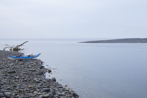
Raft Island from Kopachuck St Park.


You can launch from Fox Island, Horsehead Inlet, or from other points north of the park. For a longer trip, consider paddling in from Tacoma using the flood current. See more info in the book, Trip #7.

Raft Island from Kopachuck St Park.
Rob Casey's Blog

Rob Casey isn't a Goodreads Author
(yet),
but they
do have a blog,
so here are some recent posts imported from
their feed.

