
Rob Casey's Blog, page 2
September 15, 2019
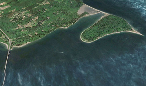
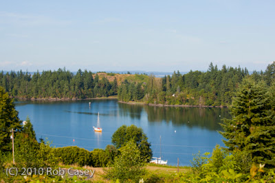
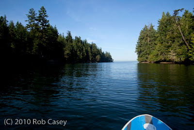
Paddling the Port Washington Narrows - Bremerton
I was excited when a former Ballard resident and friend, now living in the Manette neighborhood in Bremerton, asked me to teach a SUP class there. I hadn't paddled the Port Washington Narrows since writing Kayaking Puget Sound in 2011.
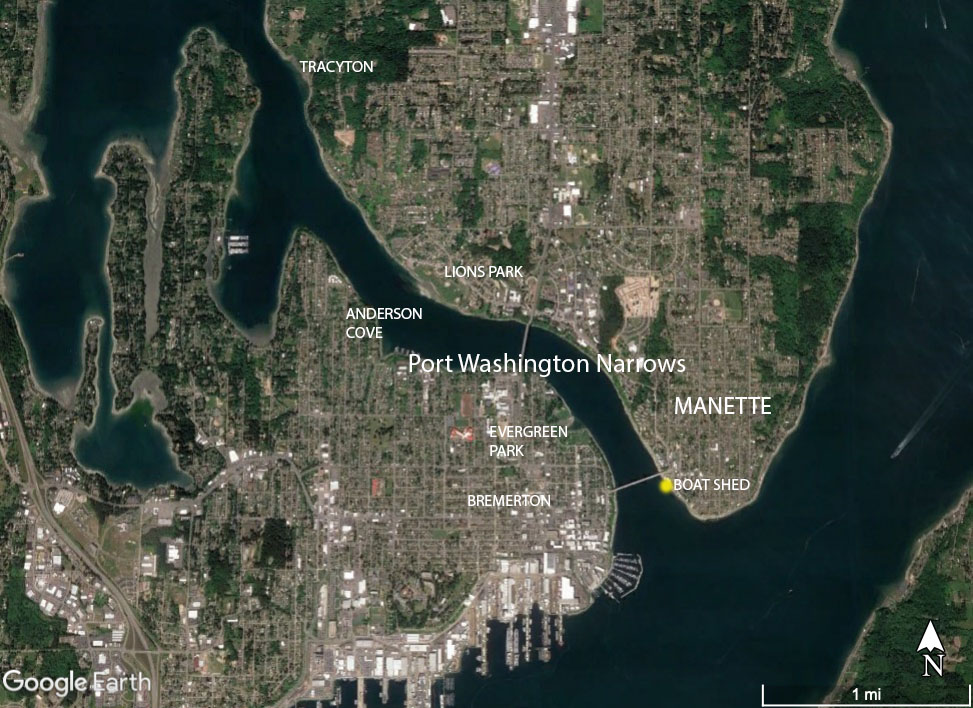
The Port Washington Narrows is a tidal stream that connects Dyes Inlet with Puget Sound. For each tidal cycle, water runs through the narrow channel up to 4 knots, sometimes higher.
My class was a beginning SUP class with five students. My goal was to teach them the basics in a protected area, free of current, then take them up and/or down the current.
We launched at Lions Park, covered the basics in an eddy, then paddled south against the flood, but in a protected eddy, towards downtown Manette and Bremerton. At the Warren Ave Bridge, we played in some boils and light eddy lines behind the bridge supports, and showed them how to ferry across current.
Then we headed up the Narrows using the approx 3 knot flood getting a free ride back to Lions Park.
It was fun introducing the Bremerton residents to a new perspective in their town. The empty beaches were lined with madrone trees.
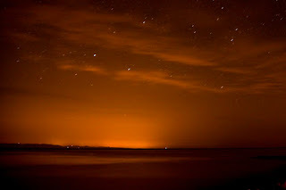
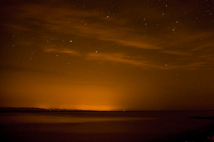
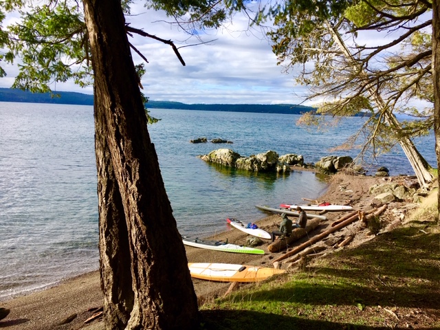
Despite a 16 knot SW wind, it was glassy in the Narrows between the bridges. A local paddler friend mentioned waves can develop in the Narrows when wind bucks current. Where to Launch below pics.

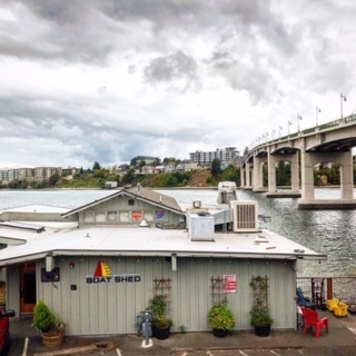 Dock at the Boat Shed for a beer and bite. Located in Manette.
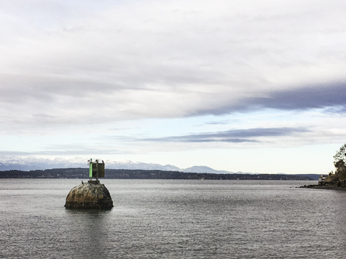
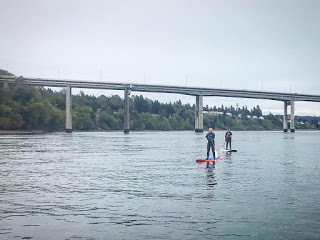 Riding the flood below above the Warren Ave Bridge
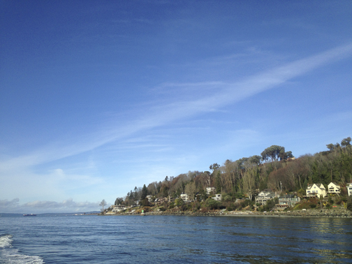
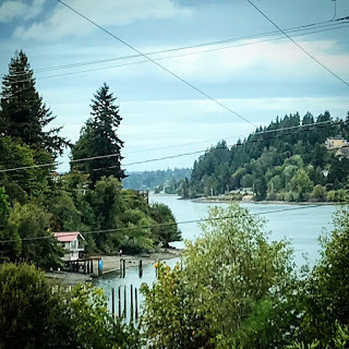 Pocket view of the Narrows and Anderson Cove from Lillian Walker Park
Good Put-ins..
-Lions Park-Lillian Walker Park (nice protected cove)-Evergreen Park (nice protected cove)-2nd Street, downtown Bremerton -Bachmann Park-Tracyton Boat Launch
Warning! Watch for swift current around bridge supports, pilings and marinas. *Paddle Boarders - wear a waist quick release leash to avoid foot entanglement.
Get Tidal / Current info from NOAA and Mobile Graphics.
Wind Predictions: iWindSurf, WindAlert, Windy

The Port Washington Narrows is a tidal stream that connects Dyes Inlet with Puget Sound. For each tidal cycle, water runs through the narrow channel up to 4 knots, sometimes higher.
My class was a beginning SUP class with five students. My goal was to teach them the basics in a protected area, free of current, then take them up and/or down the current.
We launched at Lions Park, covered the basics in an eddy, then paddled south against the flood, but in a protected eddy, towards downtown Manette and Bremerton. At the Warren Ave Bridge, we played in some boils and light eddy lines behind the bridge supports, and showed them how to ferry across current.
Then we headed up the Narrows using the approx 3 knot flood getting a free ride back to Lions Park.
It was fun introducing the Bremerton residents to a new perspective in their town. The empty beaches were lined with madrone trees.
Despite a 16 knot SW wind, it was glassy in the Narrows between the bridges. A local paddler friend mentioned waves can develop in the Narrows when wind bucks current. Where to Launch below pics.
 Dock at the Boat Shed for a beer and bite. Located in Manette.
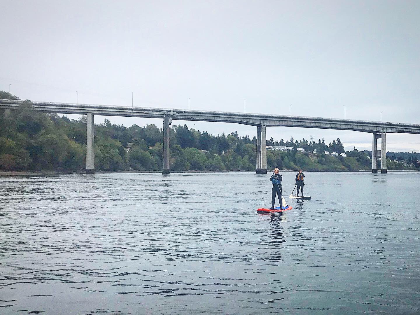 Riding the flood below above the Warren Ave Bridge
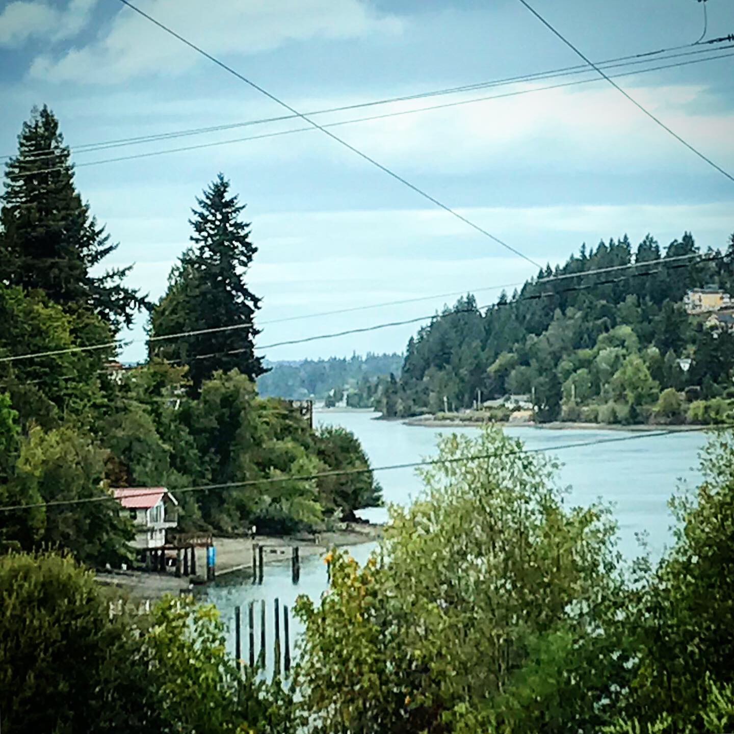 Pocket view of the Narrows and Anderson Cove from Lillian Walker Park
Good Put-ins..
-Lions Park-Lillian Walker Park (nice protected cove)-Evergreen Park (nice protected cove)-2nd Street, downtown Bremerton -Bachmann Park-Tracyton Boat Launch
Warning! Watch for swift current around bridge supports, pilings and marinas. *Paddle Boarders - wear a waist quick release leash to avoid foot entanglement.
Get Tidal / Current info from NOAA and Mobile Graphics.
Wind Predictions: iWindSurf, WindAlert, Windy


September 13, 2019
Removing Marine Debris near the Elwha River
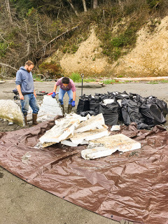
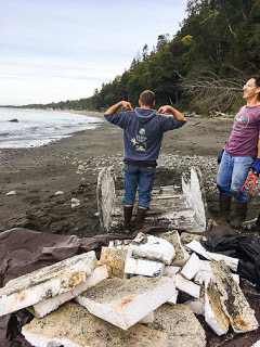
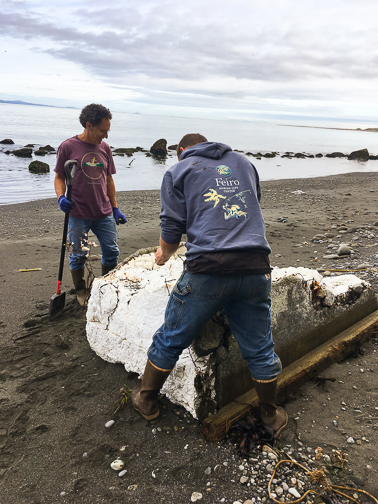
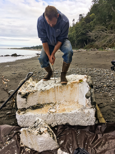
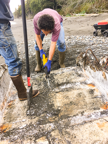
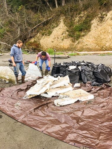
Over Labor Day weekend, a friends and I was on a beach walk along Freshwater Bay beach, west of the Elwha River mouth near Port Angeles.
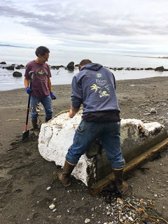
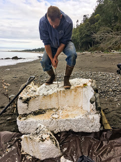
We spotted a large block thing floating in the water just off shore. Looking at it with binoculars we realized it was a piece of a dock. It soon landed on the beach and with a closer look, we realized it was mostly styrofoam and lined with concrete and metal wire.
This type of styrofoam breaks up on our local beaches leaving not only small chunks but also very difficult to remove tiny bits of bead foam. I've seen this foam in kelp beds, tide pools and on many of our NW beaches.
I immediately contacted the Feiro Marine Science Center in Port Angeles to find a solution for removing the dock. After a few days, they figured a solution to cut up the foam and remove it manually.
This week, three volunteers armed with plastic bags, plastic sheeting, cutting tools and a wagon worked for a few hours to remove the foam. Here's the photos of their efforts.
View more photos and info plus comments on my Instagram page @salmonbaypaddle
Donate to Feiro Marine Science Center which runs a small aquarium and marine education programs in downtown Port Angeles.

Thanks to these volunteers at Feiro!
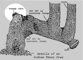
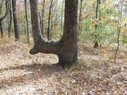
Indian Marker Trees on the Olympic Peninsula
In a recent post, I mentioned 'Indian Marker Trees' which were used by natives to show territory boundaries or point to specific things, like a good fishing spot.
Karl Kruger turned me on to looking for these. Karl completed the Race to Alaska in 2017 on a paddle board and runs sailing charters up the Inside Passage in the summer. He learned about these and 'fire trees' during these trips.
Fire trees were hollowed out at the base to create a wind protected place for cooking clams and creating charcoal. 'The Mystery of Fire Trees in SE Alaska' is a great guide on these trees.
My fascination about marker and fire trees is finding evidence of ancient cultures in plain sight, even after years of logging and development.
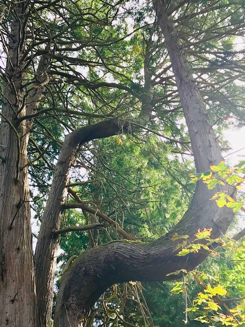
Here's two possible marker trees on the Olympic Peninsula. I've sent a photo of the Elwha tree to the Burke Museum to get some sort clarification whether it's a marker tree or a just a funky tree.
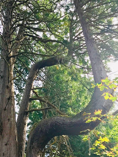 This tree is near the Elwha River west of Port Angeles
 This one is above the trail leading down the steep hill to
Shi Shi Beach in Olympic National Park. (Not sure if this one is Makah or ONP).

Karl Kruger turned me on to looking for these. Karl completed the Race to Alaska in 2017 on a paddle board and runs sailing charters up the Inside Passage in the summer. He learned about these and 'fire trees' during these trips.
Fire trees were hollowed out at the base to create a wind protected place for cooking clams and creating charcoal. 'The Mystery of Fire Trees in SE Alaska' is a great guide on these trees.
My fascination about marker and fire trees is finding evidence of ancient cultures in plain sight, even after years of logging and development.
Here's two possible marker trees on the Olympic Peninsula. I've sent a photo of the Elwha tree to the Burke Museum to get some sort clarification whether it's a marker tree or a just a funky tree.
 This tree is near the Elwha River west of Port Angeles
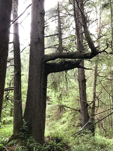 This one is above the trail leading down the steep hill to
 Shi Shi Beach in Olympic National Park. (Not sure if this one is Makah or ONP).
July 2, 2019
16 Night Paddling Tips
Night paddling is an amazing and surprisingly eye opening experience. Doing so will allow you to see your local waters in a different way and allow you to use your senses differently to safely navigate.
Here's 16 Tips for Night Paddling
(With Puget Sound in mind, but ok for anywhere)..

Here's 16 Tips for Night Paddling
(With Puget Sound in mind, but ok for anywhere)..
June 26, 2019
Indian Marker Trees in the Pacific Northwest
On a recent distance racing and expedition course with R2AK's Karl Kruger, Karl mentioned the Indian marker trees on Orcas Island, as well as fire trees and totem trees. He had seen each in the San Juan Islands and on the BC coast and southeast Alaska.
What are marker trees?
These are trees that were controlled by native people (pre-contact) so that the tree could grown to serve as a trail or territory marker or boundary. '
The idea sounded remote and nothing I'd ever seen before until he showed us examples. Once I saw the pictures, I realized I had seen these trees, even in Seattle and on the Olympic Peninsula in WA State.
This discovery made me realize I wanted to find more native culture evidence in plain sight that had not been paved over, cut down or covered by a house or building.
Similarly, fire trees were used to cook clams, create charcoal and as lighthouses to mark locations for canoes traveling at night. Read about a fire tree at Ilalee State Park on Puget Sound.
Totem trees are human faces or faces of spiritual beings carved into a tree vs creating a totem pole. Often these were found above the section of tree carved out for cooking.
Culturally modified trees seem to refer to stripping cedar bark for clothing, baskets and the like.
Marker Tree Examples:


February 9, 2019
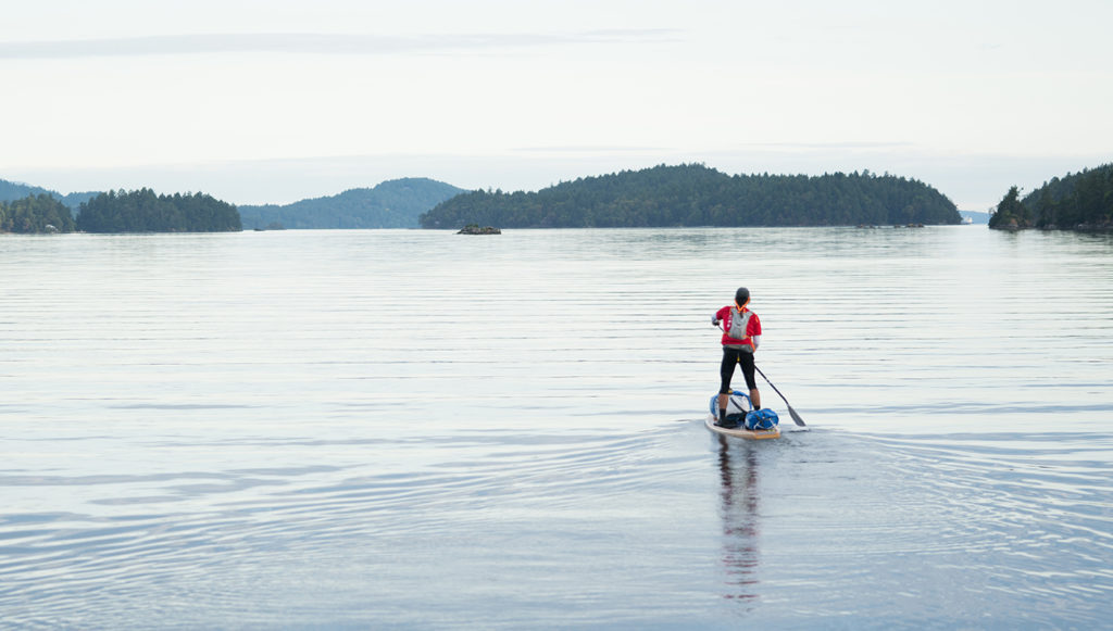
Next Expedition and Long Distance Racing Class with Karl Kruger - April 26-28th
Learn how to prepare for an overnight adventure or long distance race such as the Seventy48 with two of our region’s experts in long distance paddling on Puget Sound. Karl Kruger was the first stand up paddler to complete the Race to Alaska in 2017. He Learn more about Karl
 Our Feb class taking a break on Jones Islandcompleted the 750 mile race un-assisted on a 17′ board in 14 days. He lives with his family on their boat on Orcas Island where he offers sailing charters in Puget Sound and the Inside Passage. Rob Casey is the author of ‘Kayaking Puget Sound and the San Juans, 60 Trips’ and ‘Stand Up
Paddling Flat Water to Surf and Rivers’ both by Mountaineers Books. He has been on the board of the Washington Water Trails Association and the Paddle Sports Advisory Group with WA State Parks. See the About page on this page for more on Rob. Dates:
April 26-28We'll Cover:Hands-on Marine NavigationCross training for core strength, stability and balanceNutrition and hydration basics for trips and endurance racingBoard and gear outfitting tipsDistance trip and race tactics and strategyNight paddling skillsThe mental game of paddling long distance
Sign-Up / More Details (You’ll sign up with the Isla Vida Group on Orcas Island)
 Our Feb class taking a break on Jones Islandcompleted the 750 mile race un-assisted on a 17′ board in 14 days. He lives with his family on their boat on Orcas Island where he offers sailing charters in Puget Sound and the Inside Passage. Rob Casey is the author of ‘Kayaking Puget Sound and the San Juans, 60 Trips’ and ‘Stand Up
 Paddling Flat Water to Surf and Rivers’ both by Mountaineers Books. He has been on the board of the Washington Water Trails Association and the Paddle Sports Advisory Group with WA State Parks. See the About page on this page for more on Rob. Dates:
April 26-28We'll Cover:Hands-on Marine NavigationCross training for core strength, stability and balanceNutrition and hydration basics for trips and endurance racingBoard and gear outfitting tipsDistance trip and race tactics and strategyNight paddling skillsThe mental game of paddling long distance
Sign-Up / More Details (You’ll sign up with the Isla Vida Group on Orcas Island)
January 24, 2019
SUP Expedition and Long Distance Race Course with Karl Kruger and Rob Casey - Orcas Island Feb 1-3
Learn how to prepare for an overnight adventure or long distance race such as the Seventy48 with two of our region’s experts in long distance paddling on Puget Sound. Karl Kruger was the first stand up paddler to complete the Race to Alaska in 2017. He completed the 750 mile race un-assisted on a 17′ board in 14 days. He lives with his family on their boat on Orcas Island where he offers sailing charters in Puget Sound and the Inside Passage. Learn more about KarlRob Casey is the author of ‘Kayaking Puget Sound and the San Juans, 60 Trips’ and ‘Stand Up Paddling Flat Water to Surf and Rivers’ both by Mountaineers Books. He has been on the board of the Washington Water Trails Association and the Paddle Sports Advisory Group with WA State Parks. See the About page on this page for more on Rob. Dates:
Feb 1-3 (2 spots left) and April 26-28
We’ll Cover:Hands-on Marine NavigationCross training for core strength, stability and balanceNutrition and hydration basics for trips and endurance racingBoard and gear outfitting tipsDistance trip and race tactics and strategyNight paddling skills* Circumnavigate Shaw Island if conditions are good
Sign-Up / More Details (You’ll sign up with the Isla Vida Group on Orcas Island)

August 31, 2017
3 Easy Labor Day Weekend Paddle Escapes
Where to Paddle to Beat Crowds on 3 Day Weekends -
Side Note: How to avoid ferry lines...
Departing from Seattle - If leaving Seattle at 5pm on Friday, take the Bremerton Ferry as there's rarely a big line. I'd rather be sipping a ferry IPA coasting through Rich Passage than sitting in a parking lot. Or leave super early (7am) or super late (9pm). For the Keystone and San Juan Island ferries get a reservation.
Coming Back Monday - Arrive before peak (before 3pm) or after 9pm. Oddly, the Bainbridge Ferry is often uncrowded on Sunday evenings. Kingston gets the huge crowds from Canada and WA folks from north of Seattle. Tacoma'ans take the bridge.
3 Epic Trips -
Trip 32 - Hood Head. 15min from the Kingston Ferry, take the first Right off the Hood Canal Bridge then immediately another Right adjacent to the bridge and follow the steep road below the bridge to Shine State Tidelands and the beach. Launching there, paddle to Hood Head (The cool island seen from the bridge). There's a few boat-in homes on the island. Approach the south side and the long extended spit called Point Hannon. There's a driftwood dragon (seriously) about 50' long worth checking out. The wwta.org has a campsite on the east side. Aim for higher tides to explore ByWater Bay inside the head.
Trip #33 - Mat Mats Bay. Less than an hour from the Kingston Ferry, Mats Mats is a very protected inlet a few minutes north of Port Ludlow. Water will be calm and the narrow entry to the Sound is interesting. The rocks offshore often have large populations of harbor seals and birdlife. Views north are of Marrowstone and Whidbey Islands, Foulweather Bluff to the south. Take the first Right off the Hood Canal Bridge to Paradise Bay Road, then north of Pt Ludlow, take a Right on Vernon Road to it's end.
Trip #15 - Staycation in Seattle below the Magnolia Bluffs. Launch from 32nd Ave W below Magnolia Village. Go east to the protected Elliott Bay Marina or west along the bluffs to explore the walk-in driftwood homes, the now closed treehouse and former foundations from the 1996 Magnolia landslide. One home is still intact but sits at a weird angle which is interesting to see. Further along check out the series of massive homes perched along Perkins Lane. There's some weird outdoor art pieces in there. At Four Mile Rock (large erratic boulder with range marker on top) the view opens up to Discovery Park and the West Point Lighthouse. Freighter waves can break nicely around the corner at lower tides. Watch for current that can push you to this point, but make it difficult to paddle back. Maybe aim for ebb going out, flood coming back.
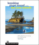
Learn more about my book Kayaking Puget Sound and the San Juans, 60 Trips. I also offer SUP and Kayak lessons available throughout the year at Salmon Bay Paddle. Questions about paddling on the Salish Sea, give me a holler anytime at salmonbaypaddle@gmail.com or 206-465-7167

August 23, 2017
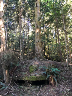
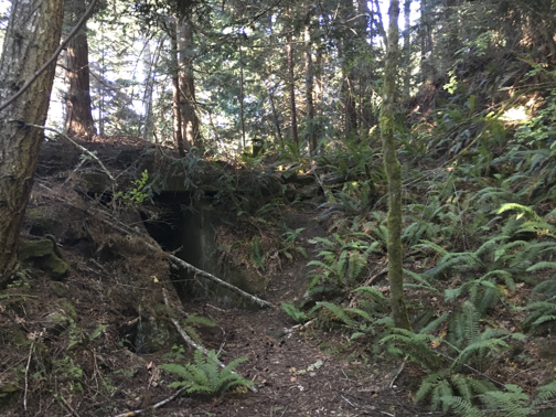
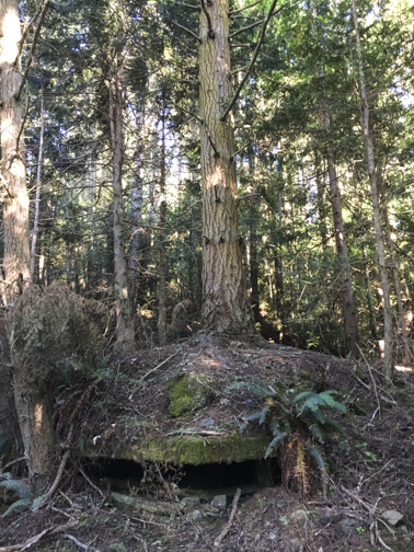
Bunker Spelunking Along the Strait
Following my interest from childhood of exploring and finding WW2 bunkers, recent research and bushwacking let me to a few more fire control stations and other oddities hidden in the North Olympic Peninsula woods.
It was interesting to see a Seattle Met article on another guy doing similar searches. But like him, I'm keeping these spots a secret for the sake of the land owners (liability) and it's rewarding to do the research and find an installment. My research has only found a few of the bunch built in WW2 along the Strait. Many are on private land, DNR land or on questionable access locations (private or not?).
These are easily found with some bushwacking around Camp Hayden. A good distraction while waiting for the tide to rise along Crescent Bay..

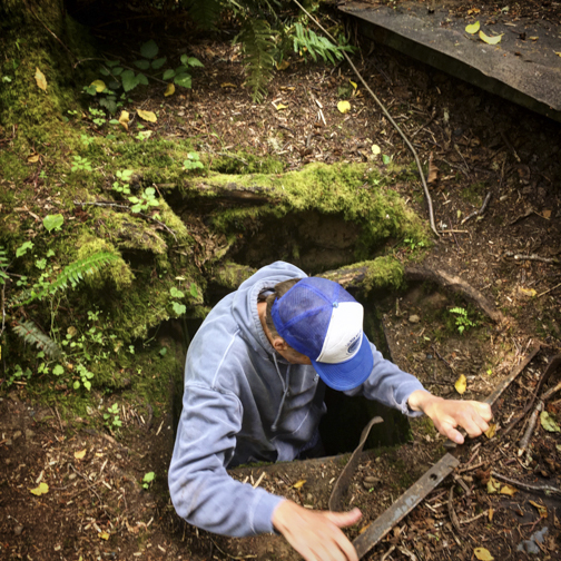
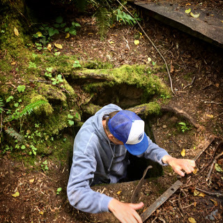 sketchy entry to a small fuel room
Learn more about my book Kayaking Puget Sound and the San Juans, 60 Trips. I also offer SUP and Kayak lessons available throughout the year at Salmon Bay Paddle. Questions about paddling on the Salish Sea, give me a holler anytime at salmonbaypaddle@gmail.com or 206-465-7167

It was interesting to see a Seattle Met article on another guy doing similar searches. But like him, I'm keeping these spots a secret for the sake of the land owners (liability) and it's rewarding to do the research and find an installment. My research has only found a few of the bunch built in WW2 along the Strait. Many are on private land, DNR land or on questionable access locations (private or not?).
These are easily found with some bushwacking around Camp Hayden. A good distraction while waiting for the tide to rise along Crescent Bay..
 sketchy entry to a small fuel room
Learn more about my book Kayaking Puget Sound and the San Juans, 60 Trips. I also offer SUP and Kayak lessons available throughout the year at Salmon Bay Paddle. Questions about paddling on the Salish Sea, give me a holler anytime at salmonbaypaddle@gmail.com or 206-465-7167
August 17, 2017
3 NW Paddling Getaways to Escape the Weekend Crowds
Looking to getaway but not sit in long ferry lines then get to your supposed remote campsite to find 30 tents already there? Here's 3 paddle-in destinations to really get away...
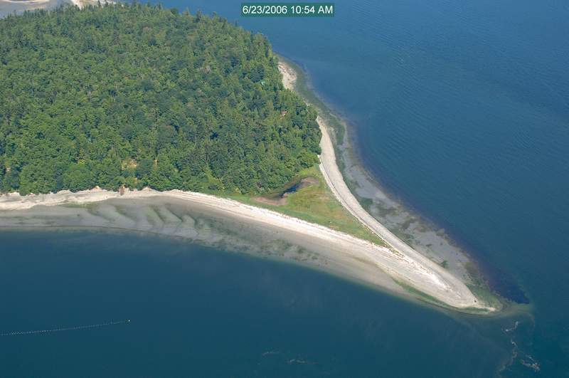
1. Marrowstone Island /Trips 34 and 35.
Just across the bay from Port Townsend, this off the beaten path island is one of the least visited State Parks in the State. On hot summer weekends, the Cascadia Marine Trail campsite adjacent to the standard campsite should be free of other paddlers. Then slip into the park and/or paddle it's quiet shores to escape the masses.
The park is also home to Fort Flagler, a 1890's era harbor defense fort with an extensive bunker system to explore as well as 200' cliffs overlooking Admiralty Inlet, Whidbey and Port Townsend.
 Strait of Juan de FucaWatch for currents of Marrowstone Point by the Light House. Smart planning with the currents can make it a fun adventure. Use Starpath's Puget Sound Currents to see how current work there. The app Deep Zoom is another tool for understanding local currents.
The island can be accessed by driving there or paddling from Port Townsend, Port Hadlock, Oak Bay Park or for the hardcore, from Whidbey.
2. Burrows Island, Anacortes. Trip #29
Burrows Island is 10 minute paddle from Skyline Marina in Anacortes. The campsite at Alice Bight is about 5-10 min further. The island is undeveloped short of the historic light house on it's west side. Trails circumnavigate the island for exploring it's very uncrowded rugged shores.
The island is a 1.5hr drive from Seattle with no ferry to Anacortes, then to Skyline Marina. Park in the long term marina parking along Cabana Lane. Then access the beach on the marina's west side where the road ends (below a house perched on a embankment / across from the big boat storage facility).
The Cascadia Marine Trail campsite has the best vault toilet in the region with a nice view as well! Alice Bight feels like SE Alaska, really a nice spot and a beautiful bay.
Watch for tidal currents during the crossing as well as fast moving power boats. If you like surfing standing waves and boat wakes, this can be a fun spot.
3. Skagit Island. Trip #27.
Close to Burrows Island, Skagit is on the other side of Deception Pass on Similk Bay. The Cascadia Marine Trail campsite rests on an shell midden (native garbage dump) that can be seen the embankment (shells and stuff). Enjoy views of Deception Pass, nearby Hope Island and Fidalgo Island.
Currents can run between the island and Kiket Island to the east. Use your tide/current guide to plan your trip. Walk the island and/or paddle over to Hope Island State Park for additional exploring.
Access from Fidalgo Island at Snee-oosh Point (about 1mile), or via Whidbey's Ala Spit, Cornet Bay, or run through Deception Pass on the flood for the best approach. Park at Bowman Bay.
2 Bonus Options for the adventurous...
Guerilla Camping.
This means camping in non designated spots along the banks of Puget Sound. There's hundreds of miles of undeveloped shoreline under bluffs, cliffs and remote beaches. Use Google Earth to explore the shore and/or play by ear and stop when you find a good place to end the day. Avoid backyards. Years ago, a friend while returning from Ketchikan on his kayak, camped in Carkeek Park. But that was 20+ years ago, I'm not sure I'd want to do that today!
Strait of Juan de Fuca - 2 Options..
-Launch in Port Angeles and paddle west past the Elwha River and Freshwater Bay camp at the Crescent Beach RV Park in Crescent Bay or at Salt Creek Recreational Area. Contact the RV park before landing there as they love to keep people off the beach. Landing at the county park may require portaging your gear up some rocks by Tongue Point. Check each location before going.
Crescent Bay in Salt Creek is a surf area so only enter on a small or no swell if you don't have surf skills. Tongue Point can get gnarly with waves crashing on it.
 Salt Creek-Launch from PA or from Salt Creek and paddle west to Whiskey Creek Resort in Joyce. This is a short paddle from Salt Creek but enjoy sea caves, arches, 500' cliffs and an odd metal door carved below that cliff. Epic paddle I've done a few times.
*Whiskey Creek was recently purchased by a new owner, so call to check their status and book a cabin or camping spot prior to arrival. Their cabins are right on the Strait, powered only by propane. No website, # only. 1385 Whiskey Creek Beach Rd, Port Angeles, WA 98363 / Phone: (360) 928-3567
*Guerilla camping along the Strait is possible but be ready to get up early if needed. Much of it is DNR land, some timber land.
 Get my book to better plan your trip!
Learn more about my book Kayaking Puget Sound and the San Juans, 60 Trips. I also offer SUP and Kayak lessons available throughout the year at Salmon Bay Paddle. Questions about paddling on the Salish Sea, give me a holler anytime at salmonbaypaddle@gmail.com or 206-465-7167

1. Marrowstone Island /Trips 34 and 35.
Just across the bay from Port Townsend, this off the beaten path island is one of the least visited State Parks in the State. On hot summer weekends, the Cascadia Marine Trail campsite adjacent to the standard campsite should be free of other paddlers. Then slip into the park and/or paddle it's quiet shores to escape the masses.
The park is also home to Fort Flagler, a 1890's era harbor defense fort with an extensive bunker system to explore as well as 200' cliffs overlooking Admiralty Inlet, Whidbey and Port Townsend.
 Strait of Juan de FucaWatch for currents of Marrowstone Point by the Light House. Smart planning with the currents can make it a fun adventure. Use Starpath's Puget Sound Currents to see how current work there. The app Deep Zoom is another tool for understanding local currents.
The island can be accessed by driving there or paddling from Port Townsend, Port Hadlock, Oak Bay Park or for the hardcore, from Whidbey.
2. Burrows Island, Anacortes. Trip #29
Burrows Island is 10 minute paddle from Skyline Marina in Anacortes. The campsite at Alice Bight is about 5-10 min further. The island is undeveloped short of the historic light house on it's west side. Trails circumnavigate the island for exploring it's very uncrowded rugged shores.
The island is a 1.5hr drive from Seattle with no ferry to Anacortes, then to Skyline Marina. Park in the long term marina parking along Cabana Lane. Then access the beach on the marina's west side where the road ends (below a house perched on a embankment / across from the big boat storage facility).
The Cascadia Marine Trail campsite has the best vault toilet in the region with a nice view as well! Alice Bight feels like SE Alaska, really a nice spot and a beautiful bay.
Watch for tidal currents during the crossing as well as fast moving power boats. If you like surfing standing waves and boat wakes, this can be a fun spot.
3. Skagit Island. Trip #27.
Close to Burrows Island, Skagit is on the other side of Deception Pass on Similk Bay. The Cascadia Marine Trail campsite rests on an shell midden (native garbage dump) that can be seen the embankment (shells and stuff). Enjoy views of Deception Pass, nearby Hope Island and Fidalgo Island.
Currents can run between the island and Kiket Island to the east. Use your tide/current guide to plan your trip. Walk the island and/or paddle over to Hope Island State Park for additional exploring.
Access from Fidalgo Island at Snee-oosh Point (about 1mile), or via Whidbey's Ala Spit, Cornet Bay, or run through Deception Pass on the flood for the best approach. Park at Bowman Bay.
2 Bonus Options for the adventurous...
Guerilla Camping.
This means camping in non designated spots along the banks of Puget Sound. There's hundreds of miles of undeveloped shoreline under bluffs, cliffs and remote beaches. Use Google Earth to explore the shore and/or play by ear and stop when you find a good place to end the day. Avoid backyards. Years ago, a friend while returning from Ketchikan on his kayak, camped in Carkeek Park. But that was 20+ years ago, I'm not sure I'd want to do that today!
Strait of Juan de Fuca - 2 Options..
-Launch in Port Angeles and paddle west past the Elwha River and Freshwater Bay camp at the Crescent Beach RV Park in Crescent Bay or at Salt Creek Recreational Area. Contact the RV park before landing there as they love to keep people off the beach. Landing at the county park may require portaging your gear up some rocks by Tongue Point. Check each location before going.
Crescent Bay in Salt Creek is a surf area so only enter on a small or no swell if you don't have surf skills. Tongue Point can get gnarly with waves crashing on it.
 Salt Creek-Launch from PA or from Salt Creek and paddle west to Whiskey Creek Resort in Joyce. This is a short paddle from Salt Creek but enjoy sea caves, arches, 500' cliffs and an odd metal door carved below that cliff. Epic paddle I've done a few times.
 *Whiskey Creek was recently purchased by a new owner, so call to check their status and book a cabin or camping spot prior to arrival. Their cabins are right on the Strait, powered only by propane. No website, # only. 1385 Whiskey Creek Beach Rd, Port Angeles, WA 98363 / Phone: (360) 928-3567
*Guerilla camping along the Strait is possible but be ready to get up early if needed. Much of it is DNR land, some timber land.
 Get my book to better plan your trip!
Learn more about my book Kayaking Puget Sound and the San Juans, 60 Trips. I also offer SUP and Kayak lessons available throughout the year at Salmon Bay Paddle. Questions about paddling on the Salish Sea, give me a holler anytime at salmonbaypaddle@gmail.com or 206-465-7167
Rob Casey's Blog

Rob Casey isn't a Goodreads Author
(yet),
but they
do have a blog,
so here are some recent posts imported from
their feed.

