
Doc Searls's Blog, page 17
January 22, 2025
And Now the #HughesFire
Twenty-fourth in the News Commons series.
8:10pm—The LA Times reports that the I-5 is open again. (That link goes to their ongoing coverage.) Here is what CAL FIRE says about current fires and their containment:
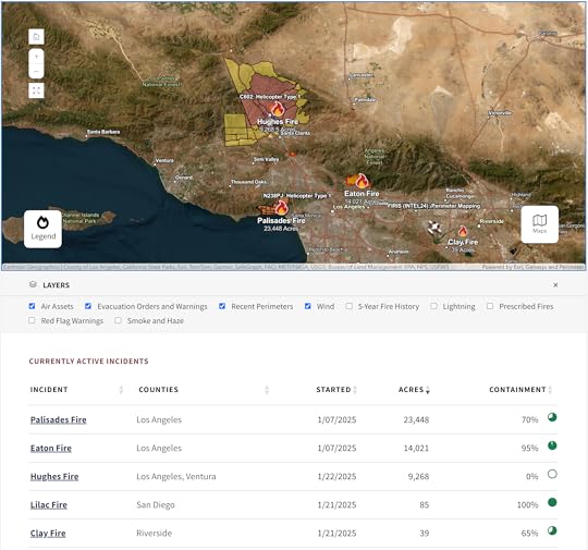
Note that the Palisades and Eaton Fires are still not fully contained, though we haven’t been worried about them in a while. The same will happen with the Hughes Fire. While it is currently 0% contained, that does not mean it hasn’t been slowed or halted along stretches of its perimeter. Full containment means firefighters are sure the fire will not spread beyond control lines. And they are very cautious about the numbers they share. The winds later tonight and tomorrow are still a concern, and thousands of people remain evacuated.
5:40pm—I just heard on one of the TV channels that The I-Five, aka The Grapevine, is likely to be opened again soon. All the channels sound more optimistic about the paths of the fire. Smoke is also flowing upwards rather than sideways, so that’s less of a concern as well.
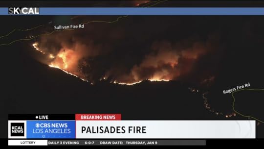
Night has also fallen, meaning the flames are far more dramatic:
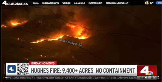
Great TV, but not more to worry about.
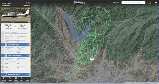
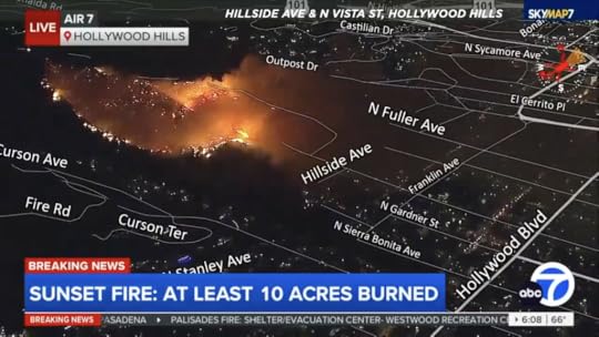
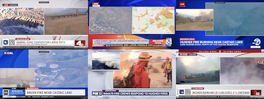 Live coverage of the Hughes Fire in Castaic by TV channels 4, 5, 7, 9, 11, and 52.
3:45pm—Watching the Los Angeles TV stations (each with a tab in my browser) cover the Hughes Fire. I have them arranged by channel number. (Note that NBC’s 4 and Telemundo’s 52 are co-teamed. One reporter’s mike says NBC4 on two sides and T—for Telemundo—52 on two sides.) Including the above, here are all the media we’re watching, reading, and listening to:
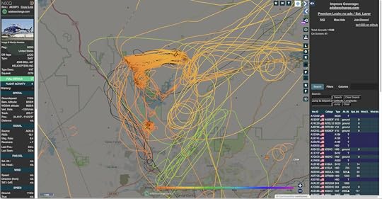
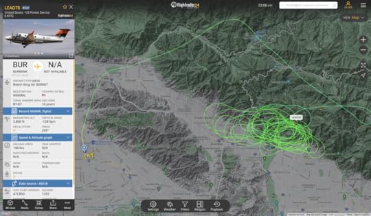
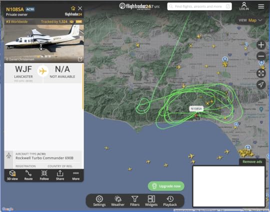
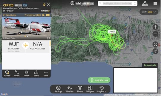
KNBC/4KTLA/5KABC/7KCAL/9KTTV/11KVEA/52LA TimesLAist#HughesFire on Bluesky#HughesFire on Facebook#hughesfire on Instagram#HughesFire on Threads#HughesFire on XI’m also watching aerial fire fighting (aircraft, paths) on adsbexchange.com and FlightRadar24. Linked images from each:
On the plus side, the concerns here are for outer suburbs and exurbs on a landscape of hilly grassland and chaparral. Compared to the steeper San Gabriels (such as those above Pasadena and Altadena), the civilized stuff is relatively defensible, with fire breaks on the ridges and bare spaces around at least some of the housing developments and other collections of structures. Winds are not too strong for aircraft, which have been able to drop water and lines of retardant. It helps that Castaic Lake itself is an enormous fire break, as well as a convenient source of water to scoop up and drop on the fire.
So, while there is lots of danger here, especially if the winds get too high for aircraft to keep flying, I expect the fight against the HughesFire to succeed.
If we can back off the edges of our seats a bit, it should be interesting to look at coverage of the #HughesFire through the prism of story. Again, the three requirements are:
Character(s)Problem(s)MovementAnd the four stages of coverage are:
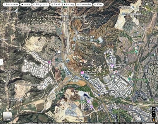
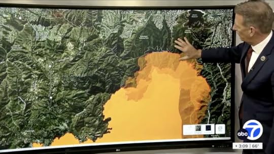
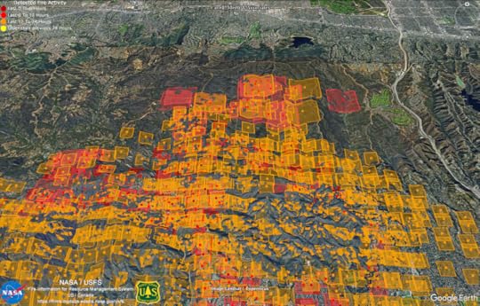
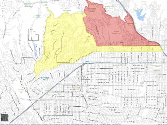
Live reportingHuman interestBlameComing to an understandingAt this stage, the main character is the Hughes Fire, which is also the problem. And it’s moving. Of course all the media like to bring the human characters in: a resident, a fire captain, a county official, a store owner. Not long ago one of the TV stations interviewed an insurance guy holding a book full of checks he was ready to write to policyholders. That’s also what we get with the mix of the first and second kinds of coverage. No blame yet, but (as they say in social media reels) wait for it. Understanding, of course, will take the longest. Here’s a screen grab from Google Maps that will tell at least some of what isn’t much of a story yet (not much character or movement), but there is an expression for it what you see: the Wildland-Urban Interface (WUI). Read about it at that link. See it here, in the path of the Hughes Fire if it isn’t stopped:
And here is a wider view of the whole region:
With the exception of the Chiquita Canyon Landfill, all of the bare areas are housing developments. All of the housing and industrial developments used to be bare areas. And all of both used to be desert mountain grasslands and chaparral. Throughout the natural history of the area, at least since the end of the Pleistocene, burns from natural causes cleared off the land about every twenty-five years or so. And all the mountains were produced by earthquakes. I’ll write more about all of this in my next post.


January 19, 2025
The Blame Game
Twenty-third in the News Commons series
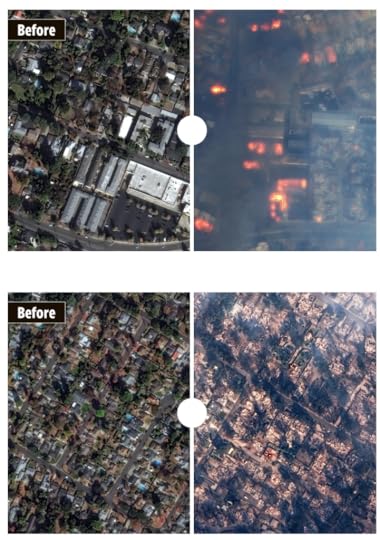
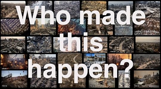 Images from a Google image search for “LA fires aftermath.” Sources listed below.†
Disaster coverage tends to go through four stages:
Live reporting. TV stations stop all advertising and go into round-the-clock coverage. Radio stations drop the feeds from elsewhere and go wall-to-wall with live reports. Newspapers drop their paywalls. Coverage by the best of them ranges from good to heroic. As stories go, they are all about the problem.Human interest. The worst is over, so the stories go to human loss, resourcefulness, forbearing, kindness, and mendacity. Reporters on TV stand in front of some hellscape and talk to victims, heroes, or anyone they can find. This leverages the need for characters and their problems, with stories about how they survived, who or what they lost, always at least with hints toward movement forward.Blame. This is all about character. Reporters are taught to seek the five W’s: Who, What, Where, When, and Why, sometimes appending an H for How. But since stories always require characters, Who is what matters most.Coming to an understanding. While that’s the goal, and something nearly everyone wants, it’s provisional while the story continues. Also, full understanding, if it ever comes, will be at the end. And stories like the LA fires may never end, because there are contexts for them that may never change.But that’s where we are now. In Stage 4. Here’s a Google search I just did:
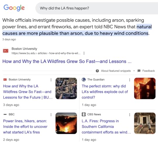
Note that all of these stories are one to three days old. All of them are provisionally conclusive (meaning they still keep the story going). And all of them are less interesting than Stage 3: Blame.
I want to focus on that because blame makes story-telling—and story-generating—easy. Too easy.
That’s why Donald Trump—the best story-generator (and blame-placer) the world has ever known (and I mean this seriously)—wasted no time fingering Gavin Newsom:
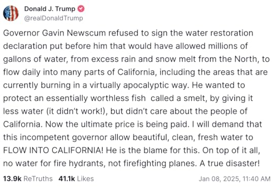
Politifact spent 942 words explaining, among other things, that there was , that a “water restoration declaration” never existed, that the smelt thing concerned water for elsewhere, and that what Trump said was wrong in other ways. But, as Ronald Reagan said, If you’re explaining, you’re losing. And Trump never loses, because that’s out of character. (Again, I mean this seriously. We’re talking stories here. The man is all-character, all the time.) And it is impossible for the media, which now includes everybody, not to participate in his story processes.
Of course, stories being what they are, Trump has hardly been alone in playing the blame game. Scott Galloway:
LAFD Chief Kristin Crowley took time out from fighting the fires to blame Mayor Karen Bass for cutting $17.6 million from the department’s budget. The department’s $895 million budget actually increased by $58 million as a result of the latest union contract. To get that higher pay to firefighters, the department reduced spending on equipment and training. The mayor’s response added to the drama, fueling rumors that the chief had been fired. Right-wing podcasters blame Fire Chief Crowley’s gayness, saying she was a DEI hire. Note: She has outstanding qualifications.
For all the good work being done at Stage 4, the urge to blame will never cease.
And we need some. Justice demands it.
What kind of justice? Well, there are many: retributive, distributive, restorative, procedural, social, environmental, economic, and so on. Of all those, retributive justice is what people want most and best understand. Perpetrators must be found, punished, and made to pay.
But starting with blame is too easy, too simple, often wrong, and always incomplete. Other factors matter. Conditions. Contexts. Black swans.
That’s why coming to an understanding is far more important, especially if we want to minimize or avoid the same kinds of disasters in the future. That’s what I’ll visit in my next series of posts.
Meanwhile, some of my open tabs:
LA Times: How to help those affected by fires raging across Los Angeles County.KNBC/4: Asher Bingham, an LA artist, is drawing pictures of houses lost in the fire. “What I’m fascinated with is taking something from a picture and building a story to it,” she tells “So Asher picked up a pen and shared the artwork to Instagram with a simple offer to anyone that has lost a home in the LA fires. ‘I will draw your home for free… Three million views on that video later, there is now a waiting list of hundreds of requests.”Wired: Los Angeles Needs to Fireproof Communities, Not Just Houses.Business Insider via MSN: I’m a pilot flying a DC-10 fire bomber to battle the LA fires. This is what I’ve seen — and this is what needs to stop.Kwaai Events: Fire Resilience & Beyond with Personal AI Hackathon 2025 – $30K in Prizes.Washington Post: A key ‘weakness’ in L.A.’s wildfire strategy went unaddressed for years, Post probe shows.† Sources via Google Image search: Reuters, NBC News, Marketwatch, ABC News, Hindustan Times, ABC, NPR, USA Today, The Indian Express, Nevada Appeal, YouTube, Commercial Observer, East Bay times, CBC, India TV News, Urban Land Magazine, Hope Standard, TMZ, Yahoo, Bloomberg, Instagram, and iObserve.
January 14, 2025
How Facts Matter
Nineteenth in the News Commons series.
Facts don’t matter, or they matter much less than people think—Daniel Kahnemann
Facts don’t matter. What matters is how much we hate the person talking—Scott Adams
But facts do matter when life and death are on the line. Or when one is recovering from a life-changing situation. To help make the case for that, here are two collections of facts about the #LAfires:
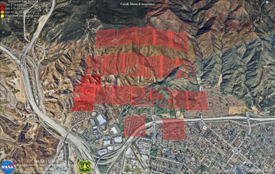
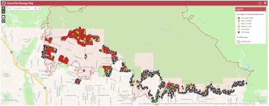 A useful visualization of the CAL FIRE Damage Inspection (DINS) database for the Eaton Fire.
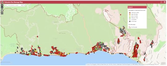 A useful visualization of the CAL FIRE Damage Inspection (DINS) database for the Palisades fire.
These are being updated on an ASAP basis by CAL FIRE (the The Department of Forestry and Fire Protection) as they inspect damage across the those two fires’ burned neighborhoods.
Here is a close-up of one section of the Eaton Fire map, with one moused-over pop-out:
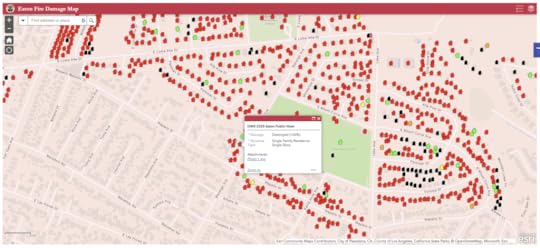
The photo link in the pop-out goes here:
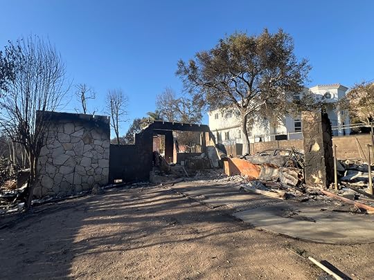
The house next door appears undamaged. That’s the green one on the map. By looking at Google Maps, I can see those houses are 3305 and 3310 North Marengo Avenue in Altadena. Note that the map has a search field in the top left corner. When one looks for an address (such as the first of those two), a pop-out appears with this:
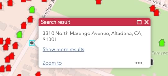
“Show more results” and “Zoom to” lead to additional information. Would it help to have a list of all the affected structures, their addresses and conditions? Sure. Exactly seven years ago, after a massive debris flow destroyed much of Montecito, California (one zip code away from our house in Santa Barbara), I posted a list like that in this blog post. My source map was this one (now at the Santa Barbara County Fire Department):
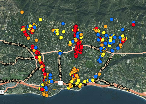
Mousing over those dots popped up an address for each one, and I used those to hand-produce a master list with the addresses for all the structures that had been lost or damaged. The idea was to have a Web page where people could quickly see what may have happened to their house—or the house of somebody they knew, using a simple text search of a Web page. Maybe somebody will do the same thing here.
I bring this up in obedience to my mother’s prime command to my sister and me when we were kids: Make yourself useful.
And that’s what I hope I’m also doing with this post. It’s not just by sharing some maps. It’s about pulling facts away from stories, which I wrote about in my last post. There I said stories are the base format of human interest, and the main product of journalism—and that they have just three requirements: character, problem, and movement.
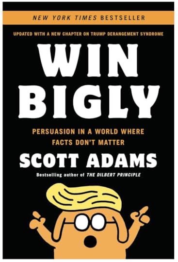
Stories serve many purposes, of course. One is persuasion. For more on that, check out Win Bigly: Persuasion in a World Where Facts Don’t Matter, by Scott Adams, of Dilbert fame:
The world where facts don’t matter is the digital one we live in now, alongside the physical one where all those homes were lost. In the digital world, the three requirements of stories can be used against journalism as well as by it. Toward both of those uses, I wrote Where Journalism Fails during the first Trump administration, and some of it bears repeating:
We have never seen Donald Trump’s like before, and may never again. His genius at working all three elements is without equal in our time—or perhaps any time. So please, if you can, set your politics aside and just look at the dude through the prism of Story.
Donald Trump spins up stories at least four ways:
Through constant characterization of others, for example with (“Little Mario,” “Low Energy Jeb,” “Crooked Hillary,” “Sleepy Joe,” “Failing New York Times”)By finding or creating problems, and characterizing those too: “witch hunt,” “fake news,” “illegal ballots,” “Dominion-izing the Vote.”By creating movement via the Roy Cohn and Roger Stone playbook: always attack and counter-attack, sue constantly, and claim victory no matter what. (Roy Cohn was a lawyer Frank Rich felicitously called “The worst human being who ever lived … the most evil, twisted, vicious bastard ever to snort coke at Studio 54.” Talk about character: Cohn was absolutely interesting. As Politico puts it here, “Cohn imparted an M.O. that’s been on searing display throughout Trump’s ascent, his divisive, captivating campaign, and his fraught, unprecedented presidency. Deflect and distract, never give in, never admit fault, lie and attack, lie and attack, publicity no matter what, win no matter what, all underpinned by a deep, prove-me-wrong belief in the power of chaos and fear.”)By playing the ultimate alpha. That’s why he constantly calls himself the winner, and “loser” is one of his favorite epithets.By de-legitimizing facts, truths, norms, and those who traffic in them. Key to this is accusing others of wrongs he commits himself. This is why he labels CNN and other news organizations “fake news” while raising falsity to an art form. Often, his accusations against others are a reliable tell of his guilt for doing the same thing.As for movement, every new problem Trump creates or intensifies is meant to generate an emotional response, which is movement in itself.Look closely: Trump’s news is deliberate, theatrical, and constant. All of it is staged and re-staged, so every unavoidably interesting thing he says or does pushes the last thing he said or did off the stage and into irrelevance, because whatever he’s saying or doing now demands full attention, no matter what he said or did yesterday.
There is genius to this, and it requires understanding and respect—especially by those who report on it.
You can call this trolling, or earned media coverage, meaning the free kind. Both are true. Comparing Trump to The Mule in Isaac Asimov’s Foundation and Empire also makes sense. (The Mule was a mutant with exceptional influence over the emotions of whole populations. It was by noting this resemblance that I, along with Scott Adams, expected Trump to win in 2016.)
This speaks of two big fails for journalism:
Its appetite for stories proves a weakness when it’s fed by a genius at hogging the stage.It avoids reporting what doesn’t fit the story format. This includes most of reality.My favorite priest says “Some truths are so deep only stories can tell them,” and I’m sure this is true. But stories by themselves are also inadequate ways to present essential facts people need to know because they exclude what doesn’t fit “the narrative,” which is the modern way to talk about story—and to spin journalists. (My hairs of suspicion stand on end every time I hear the word “narrative.”)
So here’s the paradox: We need to know more than stories can tell, yet stories are pretty much all people are interested in. Character, problem, and movement give shape and purpose to every human life. We can’t correct for it.
That’s why my topic here—a deep and abiding flaw (also a feature) of both journalism and human nature—is one most journalists won’t touch. The flawed nature of The Story itself is not a story. Same goes for “earned media coverage.” Both are features rather than bugs because they cause much of journalism’s success and debugging them has proven impossible.
Ah, but we can debug the context of journalism, which is the world of facts—especially facts in the physical world. That’s why I’m sharing these CAL FIRE maps. Besides bein extremely useful, they highlight how much more needs to be compiled and put in useful forms, so the stories journalism tells can be as fact-based as possible. In my next post, I’ll talk about a new form that can maximize the usefulness of facts.
Bonus links:
2 Bay Area climate tech startups seek to help first responders in LA County wildfire fight features is a good story on its own, and features old friend Jackson Yip and the work his new company is doing. (NBC Bay Area)Home Losses From the LA Fires Hasten ‘An Uninsurable Future’ (Time)
January 11, 2025
What Are Stories?
Eighteenth in the New Commons series.

Several generations ago, my pal Jerry and I were cutting a hole between the ceiling studs of a rented house in Durham, North Carolina. This was our first step toward installing a drop-down stairway to an attic space that had been closed since the house, a defunct parsonage for a dead church, was built early that century. We were eager to open the space, and to see what, if anything, might be in the time capsule it contained. In the midst of this, while both of us were choking on plaster dust, Jerry asked this profound question:
What is the base unit of human consciousness?
Without thinking, I answered,
The story.
I said that because I was a journalist. And no journalist who ever worked for a newspaper has gone long without hearing some editor say, What’s the story?
Editors ask that because stories are the only things that interest people. Simple as that.
I was 22 years old and in my first reporting job when the managing editor at my paper made clear that all stories have just three requirements. Not parts. Not sections. Requirements. Here they are:
Character(s)Problem(s)MovementThat’s it.
This visual might help:

The character can be a person, a team, a cause, a political party, or any noun in which you can invest an emotion. Love and hate work best, but anything other than indifference will do. You can also have more than one of them, including yourself, since you are the main protagonist in every one of your life’s stories.
The problem can be anything that involves conflict or struggle. Problems keep you tuned in, turning the page, returning to see what happened, what will happen next, or what might happen. There can be any number of problems as well. You can soften these by calling them a challenge, but the point is the same. Stories don’t start with Happily Ever After.
Movement has to be forward. Thats it. You don’t need a conclusion unless the story ends.
Take away any of those requirements, and you don’t have a story. Or a life. Or anything interesting.
Look at everyone you care about, everything you want, every game you play, every project you work on, every test you take, every class you attend, every course you study, every language you learn. All are stories or parts of them, or pregnant with the promise of them. Because stories are what we care about.
Think of those requirements as three elements that make the molecule we call a story.
Now think of every news medium as a source of almost nothing but story molecules.
Is that all journalism should be?
I submit that stories are pretty much all journalism is.
I harp on this because journalism (the good and honest kind) works in the larger environment we call facts.
We can have better stories if we have more and better facts.
And, if we preserve both stories and facts, we’ll have better journalism.
My next post on this, tomorrow, will be about facts.
Can we make those more interesting as characters?
Only if we can make clear what their problems are, and how we—the story-tellers—can make the most interesting use of them.
Are you still wondering what Jerry and I found in that attic?
Alas, nothing. But it did make a useful space.
Decades later, it looks pretty good, and I see there’s a nice window in the front dormer:
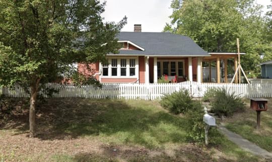
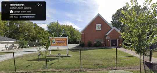
The address is 1810 Lakewood Avenue. I also see the dead church behind it, at 1811 Palmer, is now a live community center:
I have more stories about both of them… How there was once a shoot-out in the back yard. How our cat (named Motorcat, because you could hear him purr in another room) was such an alpha predator that he took out countless large rats, and once ate a rabbit in the kitchen while we were gone, leaving just one little bone. How the least pesty mouse, called Old Half-tail, asked me with gestures to move him to the woods somewhere, so he’d be more safe. How we could still heat the place with anthracite coal in the original fireplaces that were built for it. The list goes on.
All of that is not much as history, but there are facts involved that might be interesting to the current owners, who (we can see) are working on expanding the place.
The world is full of such stuff. Let’s make better use of as much as we can find.
I’d like to start in Los Angeles, where the need for good facts is extremely high right now, and so many places where facts were kept—over twelve thousand homes, at last count—are gone.
We have the Internet now. We have AI. In these early decades of our new Digital Age, our collective tabula is still mostly rasa. Writing facts on it, and not just stories, should be Job One for journalism.
Aviation vs. Fire
3:22pm—Hats off to Miles Archer for the links below, one of which goes here—
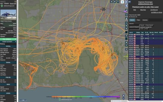
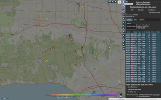
—showing all the aircraft and their paths at once. You can start here at https://globe.adsbexchange.com/, which is kind of your slate that’s blank except for live aircraft over the Palisades Fire:
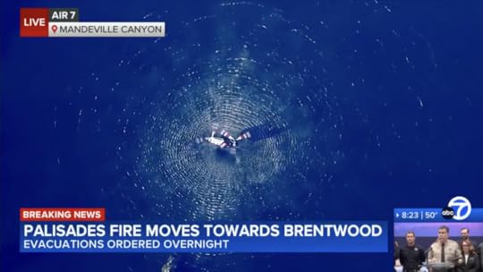
Meanwhile all the media are reporting one home loss, in the 3000 block of Mandeville Canyon Road in Brentwood.
As you can see above, most of the action right now is on the north flank of the Palisades fire, along the crest of the ridge:
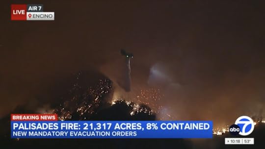
Here is a Chinook dropping water alongside Mandeville Canyon Road near where it adjoins Mulholland Drive:
I should pause here to say I’m just getting acquainted with ADS-B Exchange, the “World’s largest source of unfiltered flight data.” Here’s the About page. Bottom line: “In essence, ADS-B Exchange is more than just a flight-tracking website; it’s a dynamic, collaborative community committed to bringing transparency and inclusivity to the world of aviation.” It has a pile of social channels, and lots of ways to join in.
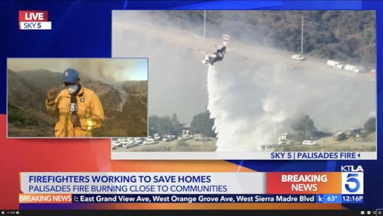
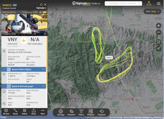
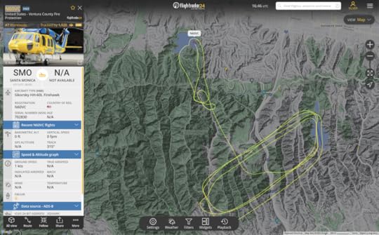
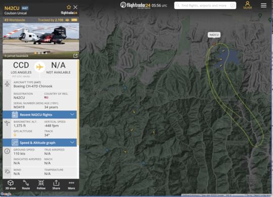
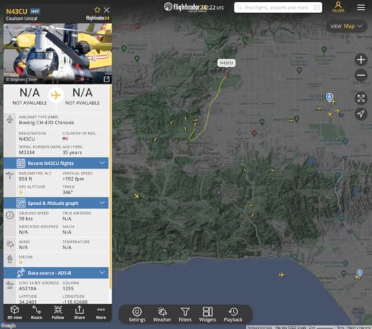
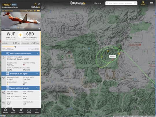
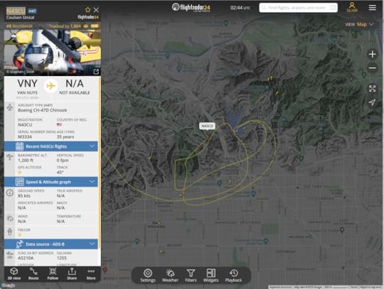
9:00am—The battle against wildfires in Los Angeles is almost entirely won by aerial firefighting. Helicopters and airplanes dropping water and retardants on fires and along perimeters saved Hollywood from the Sunset Fire two nights ago. They saved Encino from the Paradise Fire last night, and they are saving Brentwood right now. What we see above, thanks to KABC/7, is N43CU, a Boeing CH-47D Chinook, gathering water in Stone Canyon Reservoir to dump on the Palisades Fire in Brentwood. Here is its recent flight path, thanks to FlightRadar24:
And here is N60VC, a Sikorsky HH-60L Firehawk from Ventura County Fire Protection, filling up in the Encino Reservoir and running its routes over the fire:
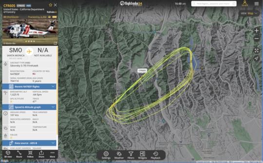
And here is Cal Fire’s CFR605, a Sikorsky S-70i Firehawk:
They can do all this because the winds right now are relatively calm, as they also were last night above Encino and the night before above Hollywood. When the winds are too strong for them to handle, we have what happened to Pacific Palisades and Altadena.
Some flights are mysteries (at least to me), but seem to have some relevance, such as this Piper out of Riverside, weaving back and forth across three of the fires regions:
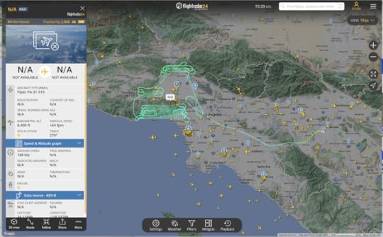
I want to know more about that one because I want to know more about everything, and to share as much as I can, as much for historical reasons as well as to satisfy current curiosities.
Anyway, if all goes well, the fire will burn a maximum spread of fuel (desert grass, forest, and chaparral), creating fire breaks good for a year or two—and then stop spreading short of houses and neighborhoods. Lord willin’ and the wind don’t come all thes fires will be sufficiently contained.
Also, if we’re lucky, Winter—our rainy season—will finally arrive, all the brown will turn green, and the fire season won’t return until late Spring.
Three bonus links:
The Architects Of L.A.’s Wildfire Devastation, by Katya Schwenk in The Lever. She makes a sensible case against development in areas such as the ones being saved in Brentwood right now. But she doesn’t mention a second danger. That’s why you need to read—Los Angeles Against the Mountains, by John McPhee in The New Yorker . That ran in 1988, and later in his book The Control of Nature . McPhee is the Shakespeare, the Rembrandt, the Beethoven, of nonfiction. What he says about where and how we live with danger is essential for making sense out of both the fires today,and the debris flows they assure when big rain comes. Which it will. A pull-quote: “The phalanxed communities of Los Angeles have pushed themselves hard against these mountains, an aggression that requires a deep defense budget to contend with the results.”Making sense of what happened to Montecito, which I posted here in 2018.January 10, 2025
Palisades Fire on the Ridge
10:15pm—Here is a Google Earth Pro view of the Palisades fire crossing the wilderness north of Pacific Palisades and south of “Dry Mulholland”—the dirt road that serves as a firebreak along the ridge of the mountains south of the San Fernando Valley:
The large squares are MODIS satellite fire detections. The smaller ones are VIIRS. The fire is now farther north (toward the top) than you see here, and being fought by aircraft on the ridge:
I count ten aircraft including the Chninook whose flight path I’ve highlighted. Note three more on Encino Reservoir, scooping up water to drop on the fire, or on vegetation—in this case surrounding Mandeville Canyon, an enclave in the floor of the canyon south of San Vicente Mountain Park. By the way, these helicopters can carry and drop 3000 gallons (I think I just heard) and can refill in just 90 seconds.
Encino, north of the ridge, is being evacuated, wise precaution.
It’s important to note that winds are calm, allowing aircraft to do their work. This was not possible while Pacific Palisades and Altadena were largely destroyed by the Palisades and Eaton Fires. It was possible during the Sunset and Kenneth fires.
KABC/7 ha dramatic video, but also reports that the fire appears to be contained. One grab:
The Los Angeles Media Dashboard
Seventeenth in the News Commons series.
While I’ve been writing about the #LAfires, this has been my main media dashboard:

Those are tabs for five TV stations, one radio station, and one newspaper:
KNBC/4 “4 Los Angeles”KTLA/5 “LA’s Very Own”KABC/7 “7 Eyewitness News”KCAL/9 “KCAL NEWS CBS Los Angeles”KTTV/11 “Fox 11 Los Angeles”KPCC/89.3 “LAist”Los Angeles TimesNote the order. I come from the Dial Age, when radios and TVs looked like those things on the left and center below, and the LA Times had eleven sections, chock full of interesting stuff, on the right:

With their many sections, newspapers were also dials of a sort. Below the LA Times eleven sections in that photo lay the five sections of the Santa Barbara News-Press, another great newspaper, now deceased. (Both papers are from Sunday, May 21, 2006.)
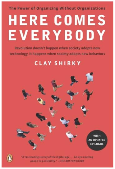
Of course, my news appetite ranges far beyond broadcast and print. That’s why I have tabs for social media in another window. Those include Bluesky, Facebook, (shoutout to Tony Pierce) Instagram, Mastodon (journa.host) Threads, Xitter, and many more, including bloggers and podcasters. That dial is my window into the world Clay Shirky wrote about in Here Comes Everybody:
That’s where I’m going in the aftermath of the #LAfires.
I want everybody to work on making news that starts with facts rather than the need to tell stories. I’ll explain more about stories and workflow in my next two posts. But first I want to unpack the portfolio of media choices we have right now.
We’ll start with newspapers. The Los Angeles Times has been around since 1881. By the time I arrived in California, 104 years later, the LA Times was one of the world’s great newspapers. My wife and I subscribed until work took us to Boston in 2007. These days, like most of the world’s surviving newspapers, the LA Times is a fraction of its former self. But it remains substantial and important. Los Angeles wouldn’t be the same without it. Its coverage of the fires, and issues surrounding it, has been substantial and extensive. Some fire-related stuff is outside the paywall, but you’ll hit one soon if you don’t subscribe. I just signed up for a year at $60, in spite of its privacy policy, which says this:
We may disclose your information to any agent or company that is part of The Times Parties to provide the Services or advertising or to communicate with you on our behalf.
We may provide access to or disclose your information to select third parties who perform services on our behalf. These third parties provide a variety of services to us, including without limitation billing, sales, marketing, provision of content and features, advertising, analytics, research, customer service, shipping and fulfillment, data storage, security, fraud prevention, payment processing, and legal services…
We may disclose your information to third parties for their own and sometimes our own advertising and marketing purposes, with whom we have a contractual relationship, including without limitation third-party advertisers and advertising and list brokering networks.
In other words, we will do our best to monetize your personal information any way we can—along with all the entities you never heard of, to which information about you will be spilled.
To be fair, this is no different than every other entity supported by surveillance-based advertising (aka adtech), which I have been fighting since the last millennium. For more on that, see my People vs. Adtech series.
But I’m setting that aside here, because I want to help the LA Times, along with all the other members of the news commons SoCal needs now, more than ever. Because this disaster is the worst to hit SoCal ever, and won’t stop being a disaster for years to come.
Next, radio. While there are many fine radio stations in SoCal, only two provide round-the-clock news. One is KNX/1070+97.1. The other is KPCC/89.3, aka LAist. KNX is owned by Audacy, a bankrupt chain owner doing its best to stay alive, mostly by cost-cutting. As part of that (and subordinating of station brands to Audacy’s), KNX’s website is the minimal thing you’ll find at audacy.com/stations/knxnews. Its on-air work, however, is still primo. KPCC/LAist is owned by Pasadena City College and operated by Southern California Public Radio (SCPR), of the American Public Media Group. Like many other public stations, LAist had a big layoff last summer, but remains a very strong journalistic institution. For me, it has proven especially useful during the fires, replacing national programming with its own live coverage for the last three days, while, also partnering with KCAL/9 to carry the TV station’s audio feed much of the time. And (unlike KNX) remaining commercial-free. Its website is also chock full of useful fire stories and resources:
One downside is the level of tracking built into the LAist website. Privacy Badger spots 42 trackers. PageXray sees 106 tracking requests, 154 adserver requests, and a personal data distribution delta that spreads quite wide:

LAist is not exceptional at this. ALL the media I’m discussing here participate in the same fecosystem. I’m calling out LAist, however, because for them it’s a dirty smudge on an otherwise clean and excellent collection of people an work.
Not quite finally, television. The major TV brands in SoCal are the ones born on VHF channels (the twelve on the upper knob above): 2, 4, 5, 7, 9, 11, and 13. We had the same lineup when I was a kid in New Jersey (across the river from New York City). The networks were also the same: CBS on 2, NBC on 4, ABC on 7. The independents were on 5, 9, 11, and 13 (which in New York became the PBS station). In Los Angeles, the CBS News and Stations Division now has both channel 2 (KCBS) and 9 (KCAL), the latter of which is now positioned as the news station. Fox owns and operates KTTV on channel 11. KTLA on channel 5 has been the alpha-independent in LA for a long time. (Disclosure: KTLA legend Stan Chambers and his very large family have been friends of my wife’s very large family, going back to the 1950s, when all lived in a close community in LA’s Hancock Park.) Since KABC/7 is one of the “Live TV” channels on our Roku TV here in Indiana, it was our first option for viewing LA fire news, especially in the early hours of the Palisades and Eaton fires. A close second quickly became KCAL, which we found has an app that runs on the Roku platform. So does KTLA. Here on my laptop, I jump around between all of them. If you look back over the last three days of reporting—
On the Palisades and Eaton Fires (January 7)On Los Angeles Wildfires (January 8)Los Angeles Fires and Aftermath (January 9)—you’ll see which of those I relied on most.
Now I’d like to zero in on this, which KABC/7 uses as a bumper between ads and segments:

I like TOGETHER. The question is, With who? Viewers, presumably. But how about the rest of what we might call the media ecosystem?
We see a little of that with the LAist-KCAL partnership. But I think cooperation can go a lot farther than that. Not in any official or even conscious way, but rather by compiling and relying together on the largest possible collection of facts about the future and the past—especially as those facts pertain to the #LAfires, their aftermath, and recovery. And by basing stories on those facts as much as possible.
And that also goes to everyone in social media, podcasting, and the rest of the fact-based news ecosystem.
Next, let’s talk about stories. Tune in tomorrow.
January 9, 2025
Los Angeles Fires and Aftermath
8:00pm It’s three hours later here in Indiana, where it is 16° and snow is approaching (and will add to the foot of it preserved by freezing temperatures since last weekend):
So I will now leave the command post in my basement office. I’ll get back on the case tomorrow morning.
Here’s hoping that all we’ll have to report then is grief over the devastation. Unlike so much else we’ve been visiting in this report, that one is incalculable, and has barely started.
7:30pm All the TV stations are mostly covering human interest stories. KPCC/KCAL are talking about how one of the “super scooper” aircraft struck a drone and was grounded after that. But they do have their own chopper, shooting the Palisades Fire, cresting the ridge of the Santa Monica Mountains. If all goes well, the winds will blow it back on itself. Meanwhile, there are plenty of aircraft on the case, as one can see on FlightRadar24. Here’s a screen grab of the fire:
6:22pm This grab from FlightRadar24 shows the collection of aircraft over the Kenneth and Palisades Fires. I’ve highlighted the flight path of the Chinook that has been making many loops and drops over the Kenneth fire:
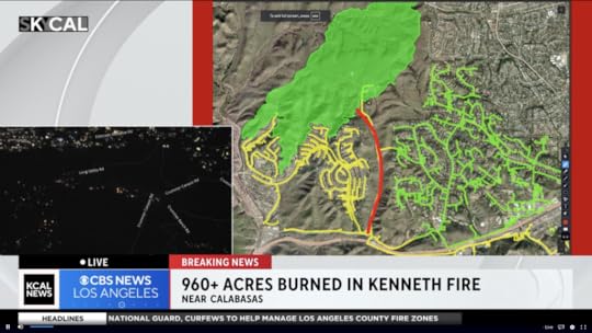
6:20pm KCAL is doing a good job of covering how well aerial fire fighting is Keeping the Kenneth Fire from destroying homes:
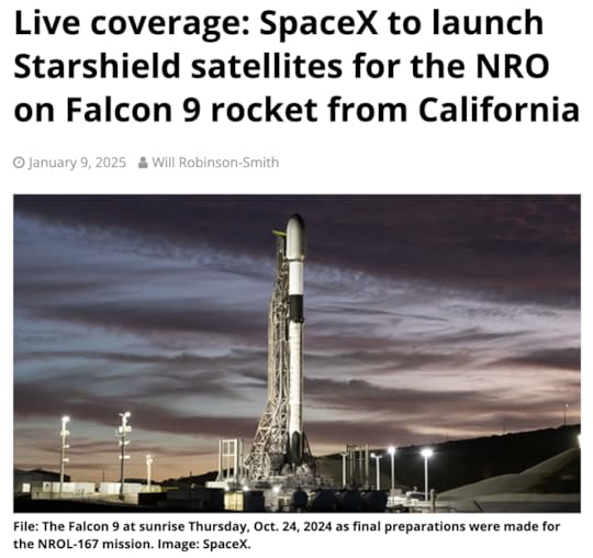
6:10pm As a break from the dread and heartache, if you’re in Southern California and can see through or past the smoke, tonight’s launch from Vandenberg should be a good show, especially as the rocket enters space, and the exhaust expands in the sunlight. More here at Spaceflight Now:
5:50pm And here is an extended video of the Eaton fire failing to burn the “Fox Compound”—the eastern-most of the Mt. Wilson TV and FM transmission facilities. It is shot from the tower cam on KNBC.4’s tower. Amazing stuff:
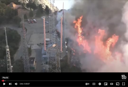
The two towers on the left are former and auxiliary ones for KTTV/11, with KTWV/94.7 farther down on the one farthest left. The two red prongs are KCOP/13 and KTTV/11’s current main antennas.
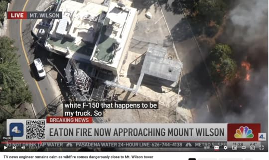
5:43pm KNBC/4’s conversation with my friend Dennis Doty at the station’s Mt. Wilson transmitter is now on YouTube. Dig how the fire comes right up to the road, live, while Dennis calmly explains that nature taking its course is no danger to the facility. A screen grab:
4:30pm Here is the flight path of the Chinook that the KNBC reporter just saw fly overhead:
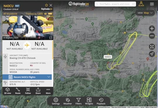
Note the many other aircraft in the area.
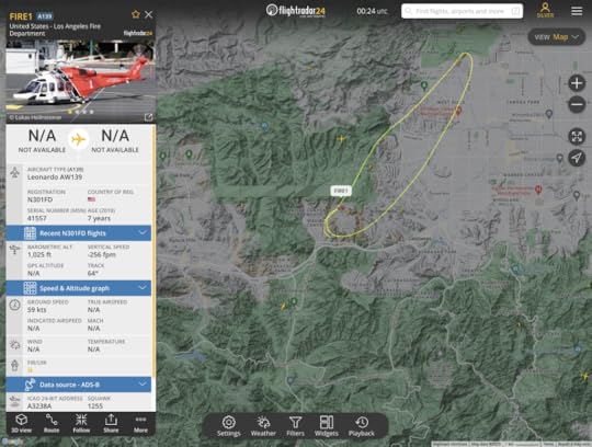
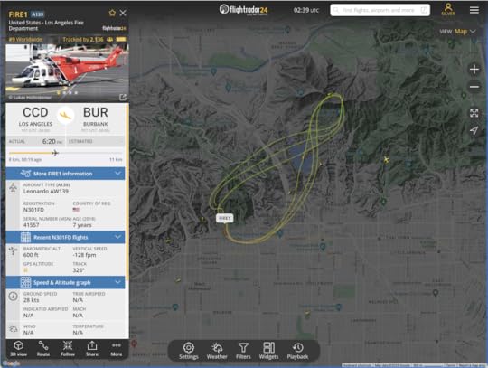
4:23pm The shot below may be of FIRE1, of the LAFD:
4:15pm Via KNBC and KCAL, the aerial assault on the Kenneth Fire appears to be succeeding for now, which is why other stations are reporting on the Palisades and Eaton fire aftermaths. Nice video from KNBC:
3:20pm Via KCAL, the Kenneth Fire is moving westward, though they are evacuating the west end of the San Fernando Valley.
3:13pm The press conference the guy with Marrone on his jacket (not sure his title) said at four to five thousand or more structures are lost. This places it third behind the Camp (18,804) and Tubbs (5,636) fires in California history.
3:10pm Flight paths from FlightRadar24 show how the new Kenneth Fire in the West Hills (Upper Las Virgenes Canyon Open Space Preserve), 50 acres large, is getting attention, along with the north flank of the Palisades fire:
3:00pm Stations are breaking away for a press conference. This is a bummer, at least for KCAL’s coverage, because they were showing exactly where the Hills Fire was moving toward streets and residences. This is in Ventura County, which will bring in new administrative bodies.
2:55pm Via KCAL/9: With wind sure to pick up (which they already are), aerial fire fighting has a lot to do, ASAP. There is another fire, called the Creek Fire, in the Angeles National Forest, near Big Tijunga canyon. Evacuations are probably coming for Calabasas, I think they just said.
2:45pm Via KCAL/9: There is a new brush fire, the Hills Fire, north of the 101 and to the west of West Hills, in the Los Virgenes Open Space Preserve. Here is the flight path of a tanker dropping water on it:
They have live chopper video:
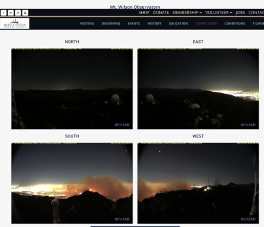
2:40pm Word on a private forum from Mt. Wilson: While the fire has been s burning uphill (to the north) the wind is downhill (to the south). There is adequate brush clearance, and firefighters are allowing the fire to clear out “flash fuels.”
1:53pm All the TV stations are covering President Biden’s press conference, with VP Harris following. One interesting thing: Harris says insurance companies cancelling coverage. We need more info about that. Randy Moore of the U.S. Forest Service is making sense about the conditions that make the fires hard to fight, and what’s being done by fire fighters. The next guy just said, I think, that 360,000 people are under mandatory evacuations. Meeting the needs of thousands who have lost homes is a huge problem. Removing debris, one official just said, will take “months to a year.” It’s now 2:22. This is going long. Mostly it’s about forms of federal support coming in… and at 2:34 stations are cutting away and summarizing the briefing. Only KTTV/11 “Fox 11” is staying with the feed… and now at 2:37 they’ve cut away as well.
1:33pm I have tabs open to channels 4, 5, 7, 9, and 11 (NBC, Independent, ABC, CBS, and Fox), and all of them are reporting stories, mostly about Pacific Palisades and Altadena, two towns that were largely wiped out in the fires. (Pacific Palisades is part of Los Angeles, and Altadena is an unincorporated suburb in Los Angeles County that presents essentially as the north side of Pasadena. (The name essentially means the higher part of Pasadena.) Most of the coverage is of the human interest kind, rather than the what’s-happening kind. So in some ways, barring flare-ups, this is mostly over.
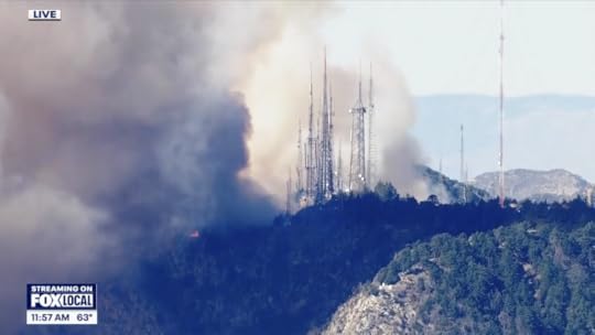
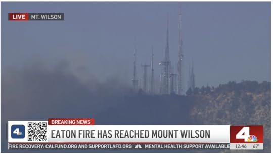
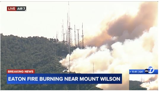
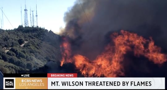
1:30pm KTTV/11: LIVE: Deadly Eaton Fire reaches Mount Wilson summit. Scroll down for the story. A grab:
12:45pm KNBC/4: Live updates: Eaton Fire flares up near Mount Wilson summit.
They just mentioned that Dennis Doty, a friend who runs the KNBC/KVEA transmitter facility (which I’ve photographed here), has been in communication with the studios, the station chopper, and the fire fighters—and sounding very calm and professional. Nice to hear.
12:37am KTLA/5: LIVE: Eaton Fire reaches the peak of Mt. Wilson. It’s a live cam view from KTLA’s property, roughly in the middle of the tower farm complex. Here are my photos on Wilson relating to KTLA.
12:31am KABC/7: 5
50-75% of Pacific Palisades is gone, ABC7’s Josh Haskell estimates. It looks like more, but hard to tell.Eaton Fire burning near Mt. Wilson.12:10am FlightRadar24 shows only two fixed-wing aircraft circling Mt. Wilson. This is one of them:
None of the TV stations seem to be covering the mountain now. Or at least I don’t see anything on their streams, or on FlightRadar24. I do know that Mt. Wilson’s transmitters are somewhat well isolated from vegetation. That gives me some hope for their survival. Nearly all the stations there have auxiliary transmitters, either elsewhere in the tower farm on Wilson itself, or on Mt. Verdugo or Flint Peak, both in Glendale.
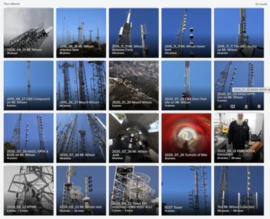
10:50 Nearly all Los Angeles’ TV and FM stations transmit from Mt. Wilson. I visit the site often. Here are twenty photo albums of transmitters on Mt. Wilson, going back to 2005. Go there and search for “Wilson.”
10:41 KABC/7 has live coverage of Mt. Wilson now:
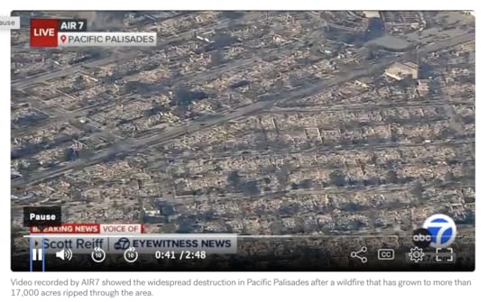
10:35 KABC/7 has an aerial video that shows clearly how much of Pacific Palisades has been wiped out. Looks like most of the town. (Alas, you do have to sit through the :30 second ad first, but it’s worth the wait):
10:29am Friends who work keeping TV and FM transmitters operating on Mt. Wilson have been sending me images of the Eaton Fire encroaching up the mountain face from the south. One just shared this on a private forum, from KCAL/9:
Here is live coverage from KCAL on the Eaton Fire.
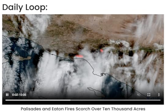
10:17am Here is the .mp4 of the daily loop from CIRA, which I think is the one the New York Post used:
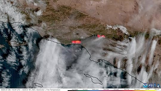
10:14am CIRA is Cooperative Institute for Research in the Atmosphere, at https://www.cira.colostate.edu/. And they have this in their Daily Loop of GOES West:
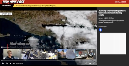
10:11am The New York Post has Alarming satellite footage shows California wildfires billowing smoke, with a disappearing video that begins with this frame showing a source: X/CIRA_CSU:
10:07am The Sun:
SCORCHED EARTH ‘Luckiest home in LA’ seen in devastating pic showing it’s the ONLY building left after whole district razed by wildfire.CITY OF FLAMES Interactive map reveals LA wildfire hotspots & celeb-packed enclaves under threat after stars among 30k forced to flee. People has more of the same, from a celebrity+landmark angle.SATELLITE pictures have revealed whole blocks of homes in Los Angeles have been burned to rubble by the wildfires, but gives no sources. One image:
11:05am Satellite Imaging Corporation should have something. Haven’t dug into it much yet. Not sure I can. I am sure they should step up and provide the public with helpful images and maps.
10:58am Nasa Earth Observatory:
Fires tear through Los Angeles. Images are from January 7. But,,,Explore more than 12,870 images has an enormous variety of scenes from above, mostly from the past, and something current is bound to show up on—Image of the Day.10:50am LAist:
What we know about the fires burning right now and staggering losses so far.Cheat sheet: A quick roundup of SoCal fire coverage and safety resources.Eaton Fire forces 100K people under evacuation orders, 5 deaths reported.Fact check: What really happened with the Pacific Palisades water hydrants? “Water supply was too slow, not too low.”10:45am LA Times:
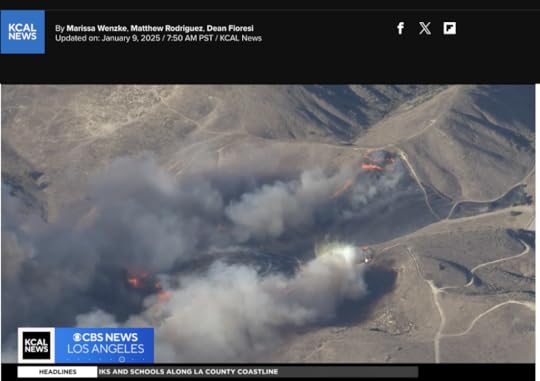
Shocking before-and-after satellite images show destruction of Malibu.Southern California wildfires by the numbers: Location, size, containment and more.One of the most destructive firestorms in L.A. history kills 5, burns 2,000 buildings.7:50am Here is what people need to know. All of these are facts rather than stories:
What homes and other buildings have burned. With addresses.What problems persist (power outages, road closures and blockages, cell coverage that’s gone, fire perimeters that are uncontained)What resources are available, where, and howAll the media are in the story business first, and the fact business second. I salute them for providing the latter (as KCAL and KABC have been doing by showing overlays of road maps on aerial views down on fires in neighborhoods). But we need facts.
Here is one: many people we know in and around Los Angeles are putting up people who have been made homeless by the fires, or have been evacuated from their neighborhoods.
Also, to make clear my connection to region, I’ve lived in California since 1985, am a permanent resident of Santa Barbara, and my wife is a born & raised Los Angelina in a family of eight siblings, nearly all of which, with their progeny and grandprogeny, have stayed in the state. We have countless friends, co-workers and acquaintances throughout Southern California. It is home for us, even though we are currently domiciled in Bloomington, Indiana (which we also love).
7:33am Resources for facts:
LADWP (Los Angeles Department of Water and Power) outage map.maps.wildfire.gov for the Los Angeles region (click on the little squares to see what’s going on there).FIRMS (Fire Information for Resource Management System) map for the same region, showing satellite-spotted hot spots. This selectively can include VIIRS, MODIS, Landsat and other sourcesSoCal Edison power outage page, which has a mapKPCC/89.3, now called LAist, is, far as I can tell, the only regional broadcaster providing continuous coverage of the #LAfires without commercial interruption. It is partnered with KCAL as well. KNX, on 1070AM and 97.1 FM, has 24/7 news, but with commercials. While its AM signal is far larger than its FM one (covering the whole West at night), it identifies as the latter.7:15am KCAL is at East Calaveras and Country Club Drive in Altadena, where the whole neighborhood, and the Altadena Town & Country Club are burned down.
6:39am KCAL/9 and KABC/7 have been my main sources of video news (over the Net, here in Indiana), and the latter is partly back to national (ABC) coverage. KCBS/2 and KCAL/9 are both CBS, and the latter is positioned as the news station, so I’m on KCAL (“kay-cal”) right now. Two screen grabs, one from Altadena and the other from Pacific Palisades:
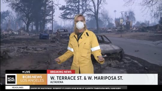
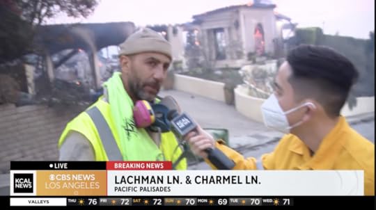 In the Altadena case, there were no surviving homes in view. In the Pacific Palisades case, the guy on the left is a homeowner who stayed to help neighbors hose down their houses and hopefully survive the fire. He and his house survived. Other houses did not. (There was no talk of fatalities, though there were some in Altadena.)
January 8, 2025
On Los Angeles Wildfires
8:02pm It appears that water dropped on the Sunset Fire has mostly contained it within a perimeter absent of houses. Good that the winds were not too high to allow that work. I also no longer see the Chinook operating on FlightRadar24, which may mean its air tanker work is done.
7:05pm Some meteorological background…
Southern California has two seasons: fire and rain. The fire season runs from the end of rain to the next rain. Winter is the rain season. Here is how rainfall usually looks:
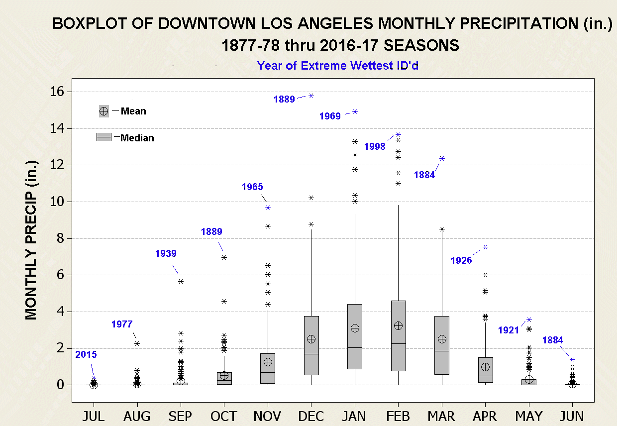 Source: Climatestation.com
Here is how Santa Ana winds look, by month at Pt. Magu, but pretty much everywhere in SoCal:
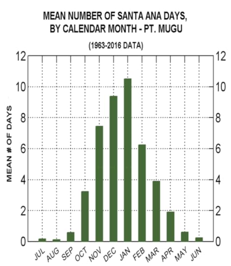 Source: ResearchGate
The problem is that there has been almost no rain so far in SoCal. So the fire season has been extended into the height of the Santa Ana wind season. A perfect storm of factors.
6:56pm Here is the Sunset Fire evacuation map, from https://lafd.org/news:
6:42:pm This is the flight path of N43CU, a Boeing Chinook, which I assume is an air tanker gathering water from the reservoir and dumping it on the Sunset Fire:
6:41pm Via FlightRadar24, here is the flight path of Fire 1, of the Los Angeles Fire Department:
6:28pm Here are views from Mt. Wilson Observatory. There is no coverage of this, but cleary fire is on the south slopes of the mountain. I have reports that KUSC/91.5, which transmits from Mt. Harvard (a peak on the city side), is off the air there. A friend who works at KNBC/4’s transmitter sent video of Mt. Harvard. That’s the one on the lower right:
6:16pm Via KNBC/4 is showing lots of traffic out while the fire trucks are trying to get in.
6:12pm Via KABC/7, the new Sunset Fire, is growing rapidly in Runyon Canyon, and vectored toward Hollywood Boulevard:
Evacuation is ordered from 101 to Mulholland to Laurel Canyon to Hollywood Boulevard. “Head south.”
3:25pm Via KABC/7. The Aldi is gone, along with many businesses on Lake in Altadena. One resident who lost a home: “The town is gone.”
Homes lost in Pacific Palisades, via the station helicopter (looking at my screen grabs):
Many on Palisades Drive, including 1447 and 17055, currently on fire.Two houses, possibly including 1297 Palisades Drive, between that road and Santa Ynez Road, on fire.Many homes already burned (hard to tell) on Chastain Parkway West, including 16899, currently on fire.Two houses on Palisades Drive across from the intersection with El Basque Court, on fire. Others appear to be burned.Monte Hermosa Drive at Cumbre Alta Court, 16805 is on fire.Two houses on Palisades Drive, one is 1946, is on fire.1846 Palisades Drive, on fire.At least one house on Paseo De Oro is on fire.16899 Calle de Sarah is on fire.3:10pm Another, of a U.S. Forest Service fixed-wing plane out of Burbank. These flight paths say something about where the action is:
Also:
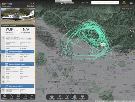
Beverly and Lake in Altadena: many fires, with helicopters dropping water or retardantMoonshadows in Malibu and many adjacent businesses and homes on Pacific Coast Highway are gone.2:56pm Here is the flight path of a private aircraft out of Lancaster, CA:
I assume it has official business.
2:55pm A Ventura County fire helicopter, observing:

2:50pm on KABC/7:
Mobile home park (surrounding Shore Drive) in Malibu across from the ocean is destroyed.Flaming homes on Mitwick in Altadena.2:45 on KCAL/CBS:
St. Marks Episcopal Church near Mariposa and Lake in Altadena, among other structures in the ‘hood, are gone.2:34pm: watching FlightRadar24 to see what aircraft are on the case. Here is one:
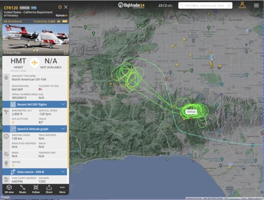
 Flight path of CFR 120, of the U.S. Forest Service, at 2:34pm Pacific
2:31pm: KCAL/CBS is covering a new fire: Lydia.
2:30pm: SoCal Edison has a map of power outages.
2:15pm KCAL/CBS :
The bungalows are gone at Palisades Charter High School, but the brick buildings are standing. Palisades Elementary is a total loss. Another elementary school is a partial loss.Homes on North Olive in Altadena are on fire.Chase Bank on Sunset in Pacific Palisades is engulfed in flames.Houses around El Molina and Sacramento Streets are down. Some are up.Fires at Allen and LaPaz Roads in Altadena.2:00 on KABC/7 has this from their helicopter (going from maps superimposed on video):
Many homes lost along Ramba Pacifico, Carbon Canyon Road, West Moon Shadows Drive, South Monte, in Pacific Palisades.Also along Palisades Drive, Verada de la Montura, Michael Lane, Avenue de la Herradura, Paseo Las Lomas.(on the ground) The Reel Inn, above Topanga Beach in Malibu, is gone. So are many houses in the area.12:50 PM Listening to KNX/1070/97.1, the all-news station for Southern California. While the station now identifies as an FM station, its AM signal at night covers the entire southwest. You can get it well at night in Hawaii.
12:43 PM LAist/KPCC and KCOP/CBS News are working together. Items from that source:
21349 Rambla Vista in Malibu is a vantage on many destroyed homes on that streetThe Pasadena Waldorf School, at Highland and Altadena (which is close to the hearts and lives of many people we’ve known) is gone, along with most of the neighborhood.12:33 PM The LA Times: Wildfire map
12:28 PM KTLA shows parts of Muir Heights in Altadena, on fire. This is west of the region above, closer to the 210 freeway.
12:13-12:25 PM CBS News Los Angeles:
The Eaton Fire has jumped west into the center of AltadenaThe Altadena Senior Center is goneChristmas Tree Lane itself is being defendedThe Bunny Museum, at Lake and Altadena may be gone.The Big Rock district of Malibu has largely burned, and many of the houses along the Pacific Coast Highway below that have burned. “More gone than standing.”Dukes in Malibu is a fire staging area. Many have taken refuge there.Lack of water is an issue in many places, given continuous demand from fire fightingHere is the FIRMS map of the Los Angeles fires, as of 7:50am Pacific time:
 The VIIRS and MODIS satellites pass over about once every 100 minutes. Neither has picked up on the Woodley fire yet. That one is in the Sepulveda Basin Recreation Area, which is the northwest side of the intersection of highways 101 and 405. The three fires you see here are Palisades (bottom left), Eaton (right) and Sylmar (top). Worst so far is the Palisades fire, which for me recalls the fire in Maui that erased Lahaina in 2023.
Here is a close-up of the Palisades fire as of about an hour ago:
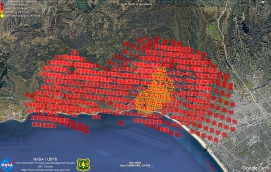 The Palisades Fire, seen by VIIRS.
Here is the Eaton Fire:
 The Eaton Fire, as seen by VIIRS.
And here is the Sylmar Fire:
 The Hearst Fire (formerly called the Sylmar Fire), as seen by VIIRS.
A request to TV stations covering the fires: tell us your exact locations when you are showing burning structures. I thank KABC/7 for reporting at length from these locations:
Creekside Court and Dove Creek Lane in Altadena’s Eaton Canyon, west of Eaton Wash and south of New York AvenueStartouch Drive in PasadenaPalisades Village and Palisades Charter High School (the latter of which is gone)Pacific Coast Highway on the shore sides of Pacific Palisades and Malibu. Much here has burnedJanuary 7, 2025
On the Palisades and Eaton Fires
We’re watching KABC/7 from Los Angeles, live on our Roku TV (which has it among hundreds of “Live TV” channels), and in a browser on this laptop. One screen grab:
 KABC/7 live coverage of the Palisades fire, and the new one a Eaton Canyon in Altadena.
Fire.ca.gov has much information, and maps. Here’s one for the Palisades fire:
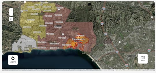 Current perimeters and evacuation areas for the Palisades Fire, via CalFire. It has since expanded to San Vicente Boulevard in Santa Monica.
Winds are so strong that there is no fire fighting on the front as it moves east and southeast. Gusts are up to 85 miles per hour.
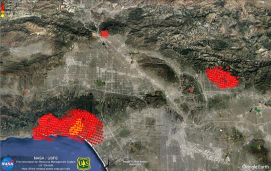
Here is a screenshot of Google Earth, with visualized data from MODIS and VIIRS satellites, which pass over regions (such as this one) of Earth fourteen times a day on polar orbits:
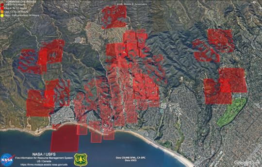 Fire detection by MODIS (the big squares) and VIIRS (the small ones), as of about 8 PM Pacific on January 7, 2025.
NASA has that data here. Look at the row titled “USA (Conterminous) and Hawaii.”
I am using Google Earth Pro. Other versions are available. See here.
More links:
BlueskyFacebookThreadsXitterNow at 8:33pm: Palisades Charter High School, (aka Pali and Pali High) with many famous alumni, just burned to the ground.
Doc Searls's Blog

- Doc Searls's profile
- 11 followers

