
And Now the #HughesFire
Twenty-fourth in the News Commons series.
8:10pm—The LA Times reports that the I-5 is open again. (That link goes to their ongoing coverage.) Here is what CAL FIRE says about current fires and their containment:
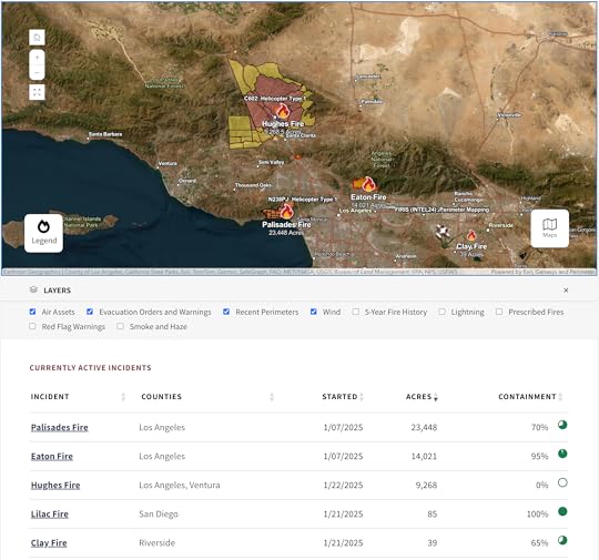
Note that the Palisades and Eaton Fires are still not fully contained, though we haven’t been worried about them in a while. The same will happen with the Hughes Fire. While it is currently 0% contained, that does not mean it hasn’t been slowed or halted along stretches of its perimeter. Full containment means firefighters are sure the fire will not spread beyond control lines. And they are very cautious about the numbers they share. The winds later tonight and tomorrow are still a concern, and thousands of people remain evacuated.
5:40pm—I just heard on one of the TV channels that The I-Five, aka The Grapevine, is likely to be opened again soon. All the channels sound more optimistic about the paths of the fire. Smoke is also flowing upwards rather than sideways, so that’s less of a concern as well.
Night has also fallen, meaning the flames are far more dramatic:
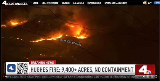
Great TV, but not more to worry about.
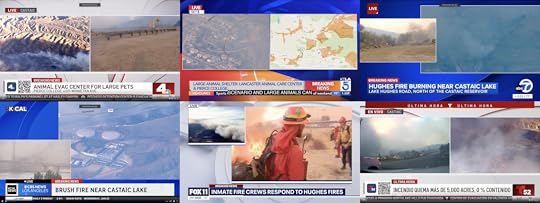 Live coverage of the Hughes Fire in Castaic by TV channels 4, 5, 7, 9, 11, and 52.
3:45pm—Watching the Los Angeles TV stations (each with a tab in my browser) cover the Hughes Fire. I have them arranged by channel number. (Note that NBC’s 4 and Telemundo’s 52 are co-teamed. One reporter’s mike says NBC4 on two sides and T—for Telemundo—52 on two sides.) Including the above, here are all the media we’re watching, reading, and listening to:
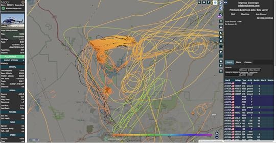
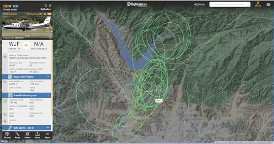
KNBC/4KTLA/5KABC/7KCAL/9KTTV/11KVEA/52LA TimesLAist#HughesFire on Bluesky#HughesFire on Facebook#hughesfire on Instagram#HughesFire on Threads#HughesFire on XI’m also watching aerial fire fighting (aircraft, paths) on adsbexchange.com and FlightRadar24. Linked images from each:
On the plus side, the concerns here are for outer suburbs and exurbs on a landscape of hilly grassland and chaparral. Compared to the steeper San Gabriels (such as those above Pasadena and Altadena), the civilized stuff is relatively defensible, with fire breaks on the ridges and bare spaces around at least some of the housing developments and other collections of structures. Winds are not too strong for aircraft, which have been able to drop water and lines of retardant. It helps that Castaic Lake itself is an enormous fire break, as well as a convenient source of water to scoop up and drop on the fire.
So, while there is lots of danger here, especially if the winds get too high for aircraft to keep flying, I expect the fight against the HughesFire to succeed.
If we can back off the edges of our seats a bit, it should be interesting to look at coverage of the #HughesFire through the prism of story. Again, the three requirements are:
Character(s)Problem(s)MovementAnd the four stages of coverage are:
Live reportingHuman interestBlameComing to an understandingAt this stage, the main character is the Hughes Fire, which is also the problem. And it’s moving. Of course all the media like to bring the human characters in: a resident, a fire captain, a county official, a store owner. Not long ago one of the TV stations interviewed an insurance guy holding a book full of checks he was ready to write to policyholders. That’s also what we get with the mix of the first and second kinds of coverage. No blame yet, but (as they say in social media reels) wait for it. Understanding, of course, will take the longest. Here’s a screen grab from Google Maps that will tell at least some of what isn’t much of a story yet (not much character or movement), but there is an expression for it what you see: the Wildland-Urban Interface (WUI). Read about it at that link. See it here, in the path of the Hughes Fire if it isn’t stopped:
And here is a wider view of the whole region:
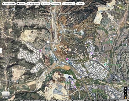
With the exception of the Chiquita Canyon Landfill, all of the bare areas are housing developments. All of the housing and industrial developments used to be bare areas. And all of both used to be desert mountain grasslands and chaparral. Throughout the natural history of the area, at least since the end of the Pleistocene, burns from natural causes cleared off the land about every twenty-five years or so. And all the mountains were produced by earthquakes. I’ll write more about all of this in my next post.


Doc Searls's Blog

- Doc Searls's profile
- 11 followers

