
John Bengtson's Blog, page 21
May 8, 2015
The Three On A Match – ‘G’ Men – Ann Dvorak connection
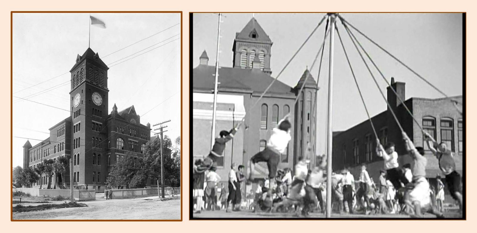
The second Los Angeles High School, located on Fort Moore Hill, appearing in Three On A Match.�� USC Digital Library.

Ann in ‘G’ Men
This post comes with a shout-out to Christina Rice, Senior Librarian overseeing the invaluable Los Angeles Public Library Photo Collection, and author of Ann Dvorak: Hollywood’s Forgotten Rebel, the wonderful biography about the spirited actress who played many standout roles during the early 30s at Warner Bros.�� Although Ann does not grace any of the locations revealed here with her presence, her sympathetic portrayal of doomed characters in Three On A Match and ‘G’ Men provide the dramatic focus for both films. For more information about Ann visit Christina’s site http://www.anndvorak.com/.

The playground scenes opening Three On A Match were filmed behind the second Los Angeles High School. The original wooden Los Angeles High School (standing in the left image directly above the arrow) was completed in 1873, and survived until it was demolished to make way for the Hollywood freeway.

Recently completed City Hall looms in the foreground (left) and in background (right) during this playground scene from Three On A Match. LAPL

Three On A Match – Lyle Talbot abducts Ann’s son beside the famous arched bridge at Hollenbeck Park.
Ann’s character in Three On A Match abandons her son and husband for a wild life of booze and drugs with a petty gambler.�� Ann’s friend, played by Bette Davis, take Ann’s son to the park, where Ann’s boyfriend kidnaps the child hoping to raise emergency cash to pay off his gambling debts. The harrowing scene was filmed at Hollenbeck Park, where many classic comedy films were staged, including Harold Lloyd’s Haunted Spooks and Girl Shy, Snub Pollard’s It’s A Gift, and the Laurel and Hardy favorite Men O’ War. Years later, the park hosted an elaborate song and dance number for the 1957 Doris Day musical The Pajama Game.

Bette Davis watches over Ann’s son as the former 6th Street Bridge spanning Hollenbeck Park appears at back. Below, a panoramic view of the park, looking south towards the bridge, from Laurel & Hardy’s Men O’ War and Harold Lloyd’s Girl Shy.

Views of the former 6th Street Bridge from Three On A Match and The Pajama Game (Doris Day at far right).

Ann holds her own with James Cagney in ‘G’ Men.
I’ve already covered many film connections between Ann’s next film ‘G’ Men and Buster Keaton’s One Week (see post describing the machine gun car chases staged in Inglewood HERE). But ‘G’ Men contains several other classic locations as well.

‘G’ Men night scene staged at the former Southern Pacific depot at 5th and Central. USC Digital Library.
During ‘G’ Men thugs rescue gangster Danny Leggett (portrayed by Edward Pawley) by staging a dramatic nighttime gun battle with the authorities in front of the former Southern Pacific depot. (A prior post devoted solely to the depot shows how Douglas Fairbanks, Harold Lloyd, and Stan Laurel all filmed early silent comedies at this spot.)

‘G’ Men – Edward Pawley is led in handcuffs from the Southern Pacific depot lobby – interior view at right. USC Digital Library.
This view below shows Edward Pawley’s train arriving at the back of the Southern Pacific Depot.�� The many awnings depicted here obstruct the view – so some films, such as Harold Lloyd’s Girl Shy, would show trains arriving behind the Santa Fe depot, and yet show the passengers leaving from the front of the Southern Pacific depot a few blocks away!

Views from behind the Southern Pacific depot – at night during ‘G’ Men, in daylight from Our Modern Maidens (1929). USC Digital Library.

The ‘G’ Men gunfight was staged on Central Avenue north of the depot lobby. USC Digital Library.
Later in ‘G’ Men, Edward Pawley is led out from the south entrance to the Hall of Justice, providing a remarkable vintage view of the one-time downtown cityscape.�� To the left stands the former Federal Building and Post Office (P) at Temple and Main, while the right reveals the side of the former International Bank Building (B).

The view from the Hall of Justice appearing in ‘G’ Men. Marc Wanamaker – Bison Archives.
Below, another view showing where Edward Pawley is led from the Hall of Justice during ‘G’ Men.

Looking east toward the Hall of Justice south entrance, and the former Federal Building and Post Office (P) and bank (B). USC Digital Library.

Matching views looking south from the Hall of Justice towards the Federal Building and Post Office (P), the International Bank Building (B), and to the right, City Hall. USC Digital Library.

Closer comparison views of the International Bank Building (B) looking west from Temple as it appeared during Bill Strother’s real-life climb staged for Safety Last!, and a view looking up Temple from Main Street at the former Federal Building and Post Office (P). USC Digital Library.
Three On A Match and ‘G’ Men copyright Warner Bros.
The restored and recently re-opened Hall of Justice.
Filed under: Los Angeles Historic Core, Pre-Code Tagged: "G" Men, Ann Dvorak, Fort Moore Hill, Hall of Justice, Hollenbeck Park, International Bank Building, Los Angeles High School, Safety Last!, Southern Pacific Depot, Three On A Match


April 16, 2015
The Three Stooges, Birth of a Nation, Forest Lawn Trees

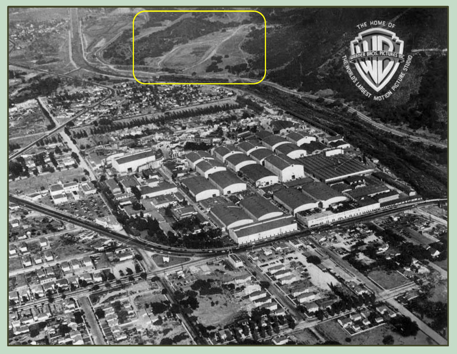
Click to enlarge. Looking east from Warner Bros. towards the Lasky Ranch. LAPL.
The former Lasky Ranch, bordering Griffith Park near Burbank, and future site of the Forest Lawn Hollywood Hills Memorial Park which opened in 1952, is steeped in movie history.�� Once part of the Spanish-era Rancho Providencia, the Lasky Ranch was used for more than three decades as a filming location for scores of Hollywood productions.�� As documented in my book Silent Visions, Harold Lloyd filmed his “rural” comedy The Kid Brother there in 1927, while Rudolph Valentino filmed exteriors for both Four Horsemen of the Apocalypse (1921) and Blood and Sand (1922) at the ranch (see below).
 As shown here, the ranch also appears in an unlikely pair of films, D.W. Griffith’s monumental and hideously racist Civil War epic The Birth of A Nation (1915), and the Three Stooges comedy short Playing The Ponies (1937).�� Several massive ancient oak trees that witnessed both productions are still standing today.

Looking east at the battle field from The Birth of A Nation.�� This post shows trees N1 and 3 above are still standing. John Hillman SilentCinema.com.
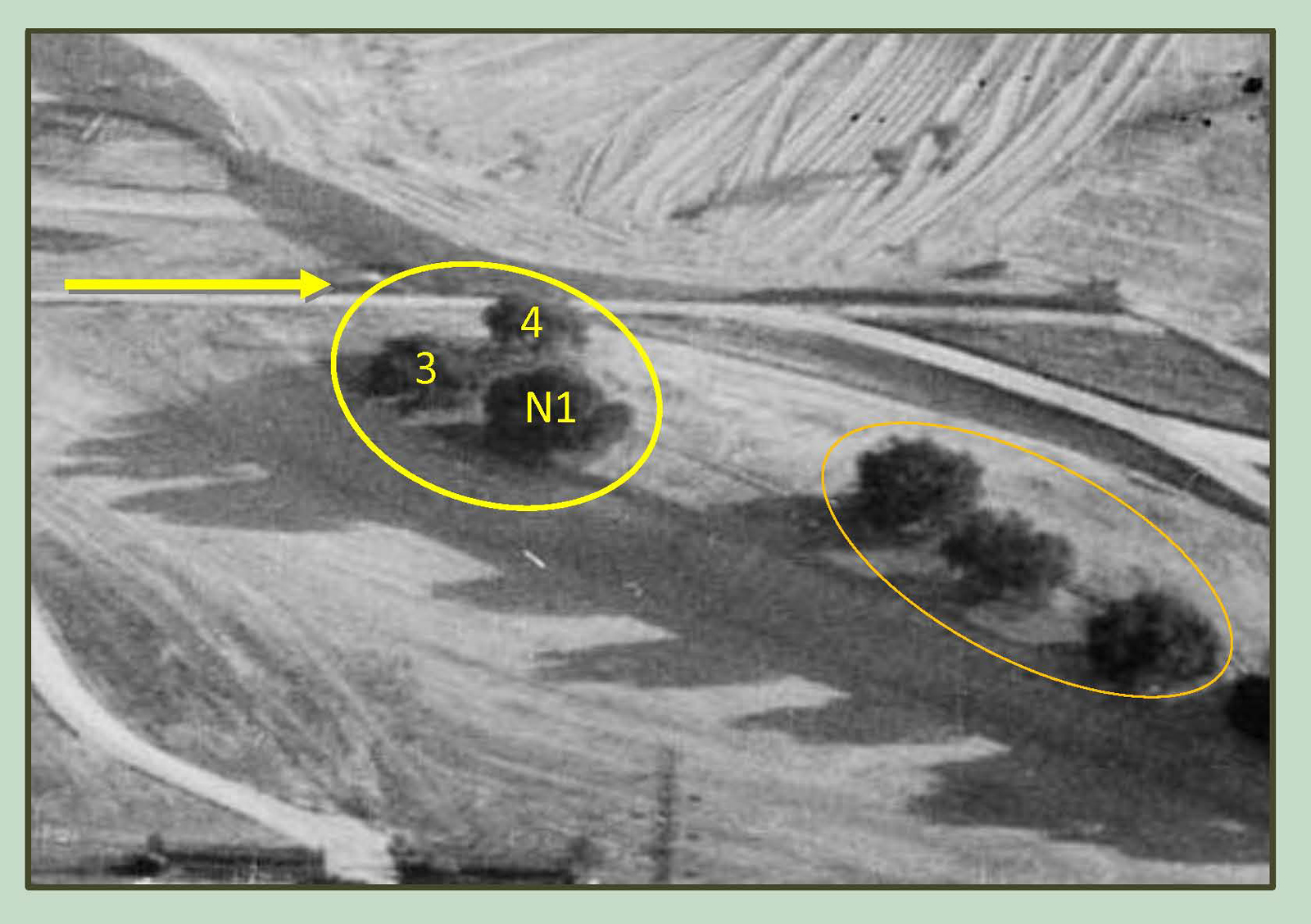
It is well-documented that Griffith staged the Civil War battlefield sequences from The Birth of A Nation at the Lasky Ranch.�� Above, by stitching together a production still from the movie, and test footage of the battlefield, both looking east, a prominent group of trees (the BOAN group) appears to the south (right) side of the field, consisting of a near tree (N1), a far tree immediately behind it (F2), a small tree standing where the two images overlap (S), and tree 3 and tree 4.�� Also visible are two hills, H1 and H2, and a path running between them.

Click to enlarge.�� Notice the BOAN group of trees (yellow oval), and the distinctive trio of trees (orange oval) . Marc Wanamaker – Bison Archives.
This circa 1922 view above looks east, showing the field of view (yellow lines) of the BOAN battlefield images above, and the dirt path between hills H1 and H2. The blue line marks the Los Angeles River.�� Beyond the hills lies a clever bullring set from Rudolph Valentino’s Blood and Sand (see below).
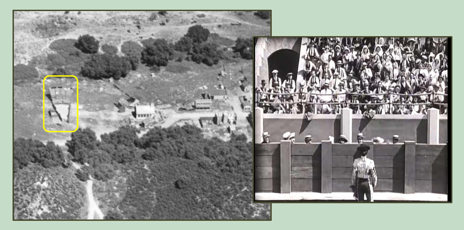
The bullring set from Blood and Sand. Only 1/16th of a full ring was needed to capture the shots.
The image below, looking south at the Lasky Ranch, references the Three Stooges in Playing The Ponies.

Click to enlarge. Looking south at the Lasky Ranch. The yellow oval marks the BOAN tree group; the orange oval marks the nearby trio.�� Marc Wanamaker – Bison Archives.
The aerial view above looks south towards the Lasky Ranch horse race track.�� The inset image of Curly, Larry, and Moe reveals trees 4 and 3, part of the BOAN tree group (yellow oval), and the same path and hills H1 and H2 discussed above.

Looking west, as Curly’s stunt double runs past the BOAN tree group (yellow) and the trio (orange).

Looking east at the rack track, and the BOAN tree group (yellow) and trio (orange). USC Digital Library.
Below, more views looking west at trees 4 and 3, part of the BOAN tree group.

Two views west towards trees 4 and 3, part of the BOAN tree group.
If you’re not overloaded by now, the following steps in my proof are even more technical, so hold on, or you can just take my word and skip to the end.�� :)���� To begin, let’s take another look at the BOAN tree group (below).

This image from Playing The Ponies provides a rare view west at the BOAN tree group.�� We’ll return to this image later.
Next, the image below shows how the Lasky Ranch was heavily graded while being converted into a cemetery, removing or changing many landmarks.�� Hills H1 and H2 were lowered (to accommodate more burial plots), and the battlefield was scraped flat.

Looking south. The battle field area from The Birth of A Nation was heavily graded to provide for more burial plots (wavy lines). Marc Wanamaker – Bison Archives.
Trees F2 and S from the BOAN tree group were lost during the Forest Lawn conversion.�� Hundreds of pine trees, now 60 years old, were later planted among the sturdy native oaks to complete the landscaping.
Detail from above. Due to the grading of the battlefield site, trees F2 and S of the BOAN group (yellow) were removed. The trio (orange) was left alone.

Click to enlarge – trees N1 and 3.
There remain today at Forest Lawn several massive oak trees, standing among smaller second and third generation oaks, and dozens of pine trees, now 60 years old, that were planted in the 1950s as part of the cemetery landscaping.�� These massive oak trees must include those that appear during The Birth of A Nation, and Playing The Ponies – but how can we be sure which is which? By using logic, aerial views from Google Maps, and studying the candidate trees in person, I am convinced that trees N1 and 3, appearing in both films, are the two trees identified at left.

How can we know the answer? By accounting for each tree.
By visiting Forest Lawn in person, it quickly became evident which tree is which.�� First, many trees in the above aerial view are pine trees, planted 60 years ago, and thus were not present during the filming.�� Next, there are a few scattered, small oak trees that represent second or third generation young growth. Then there are three massive oak trees that line up in position with the original trio of trees (orange oval).�� Likewise, we know trees F2 and S of the BOAN group were lost during the conversion.�� If we assume that tree 4, which stood away from the BOAN group, was sacrificed to make way for more burial plots, then the two massive trees standing south of the trio must be the surviving trees N1 and 3.�� Since there are no other massive oak tree candidates from which to choose, these two trees must be the ones to appear in The Birth of A Nation.

This reverse detail from Playing The Ponies shows that tree N1 has many trunks, and tree 3 is more “Y” shaped.
As final proof, the black and white image above comes from that detailed west-looking image appearing in Playing the Ponies.�� While the original view looks west, to aid with comparison I flipped the image to approximate how it would appear when looking east.�� With this visual approximation, we would expect tree N1 to have many dense trunks, and would expect tree 3 to be somewhat “Y” shaped.�� When viewed in person, trees N1 and 3 are both consistent with this expectation.
Trees N1 and 3 were already massive and old during the production of The Birth of A Nation one hundred years ago.�� Today they stand as silent witnesses to a century of movie history.
Playing The Ponies copyright Columbia Pictures Industries, Inc.
View of the BOAN trees at Forest Lawn.
Filed under: Three Stooges Tagged: Blood and Sand, Curly, D. W. Griffith, Forest Lawn, Harold Lloyd, Larry, Lasky Ranch, Moe, Playing the Ponies, Providencia, Rudolph Valentino, Silent Movie Locations, Silent Movies, The Birth of A Nation, The Three Stooges, then and now, Three Stooges

April 5, 2015
Cagney and Keaton Crossing Paths in Inglewood
 James Cagney’s crime-busting thriller “G” Men (1935) and Buster Keaton’s debut short film One Week (1920) both contain exciting scenes filmed in Inglewood.�� Cagney portrays a new FBI recruit who helps the bureau capture notorious bank robber Danny Leggett, played by Edward Pawley.�� During a crime montage Leggett’s gang robs a bank, leading to a blasting machine gun police chase on the streets of Inglewood and beside the Inglewood train station.

This aerial view of Inglewood shows two corners appearing during the “G” Men chase, the “orange” corner and the “yellow” corner (see below). LAPL.
This aerial view above shows two parts of the chase, discussed further below.�� During the “yellow” turn the cars travel north up La Brea and make a sharp turn west onto Florence Avenue traveling past a building with a curved, 60 degree corner. During the “orange” turn they travel east down Regent Street before turning north up Market Street.

Looking west down Regent from Market.
Matching views above looking west down Regent during the “orange” turn.�� The corner building had its upper floor removed, but the building west of the alley (red box) remains unchanged.

The start of the “yellow” turn – looking south down La Brea. LAPL.
The “yellow” turn in “G” Men begins with this view above looking south down La Brea towards the corner of Regent, flanked by the corresponding blue and red symbols.�� The “yellow” turn continues by sweeping quickly past a 60 degree corner building (below) that remains standing.

The 60 degree corner building standing at La Brea and Florence in Inglewood.
The “G” Men chase continues two blocks further west from the “yellow” turn, as the cars turn west from Fir Avenue, at Florence, and drive beside the train tracks that appear prominently during Keaton’s film One Week.

Turning west from Fir towards the former Inglewood train depot. LAPL.
As the cars travel west beside the tracks, the conspicuous rooftop sign for the C. GANAHL LUMBER CO., standing across from the depot, comes into view (red box).

Looking west from “G” Men to the left, and east at Buster, to the right, crossing the tracks on Eucalyptus Avenue during One Week.
I discuss this setting from One Week in my book Silent Echoes, and in these posts discussing how the same location also appears during Keaton’s talking film Speak Easily (1932), and how Buster re-worked the train gag from One Week near the future site of Los Angeles International Airport (LAX) for his 1931 comedy Parlor, Bedroom, and Bath.

Views west in “G” Men and east in One Week towards the former Inglewood train depot. The same lime storage shed (oval) appears in each image.
My thanks to Christina Rice, Senior Librarian at the Los Angeles Public Library Photo Collection, for her assistance.
“G” Men (C) 1935 Warner Bros.�� One Week licensed by Douris UK, Ltd.�� Color images (C) Google.
Filed under: Buster Keaton, James Cagney, One Week Tagged: "G" Men, Buster Keaton, Inglewood, James Cagney, One Week, Silent Movie Locations, then and now

March 20, 2015
How Laurel & Hardy Filmed Perfect Day – New Discoveries

Built in 1925, this charming bungalow at 3120 Vera Avenue near Culver City appearing in the 1929 comedy Perfect Day is one of the most popular and easily recognizable of all Laurel & Hardy film locations. Author Randy Skretvedt reports the home belonged to Hal Roach Studios electrician Bailey H. Boone, which I confirmed in the 1931 city directory.�� Thanks to Google Street View, and the help of location sleuth Jim Dallape, we���ll see that even more locations reveal themselves nearby.

I first learned of this setting reading Pratfall, the 1985 Way Out West Tent filming location guide documenting Bob Satterfield���s many Laurel & Hardy discoveries. You can see at left a large group of happy fans posing in front of the home during a 2009 tour hosted by the Way Out West Tent, the Los Angeles chapter of the Sons of the Desert International Laurel & Hardy Society. (Jim Dallape and Robert Winslow are co-creators of the amazing Hal Roach Studios Backlot Tour, hosted as part of Dave Lord Heath���s astounding Another Fine Mess website, which provides encyclopedic details about nearly the entire output of the Roach Studios.) For a better view, please CLICK TO ENLARGE each image and map below.

Out for a picnic, the family drives past their home.

Stan in front of 3116 Vera Ave. Although situated today on a corner (Regent St.), this home once stood three lots south from the original corner of Vera and Bedford Street.�� Along with Bedford, the north end of Vera was lost to the Santa Monica Freeway, visible at back.

3115 Vera appears at back. The driveway runs under an arched passage-way (yellow) now closed off with a door.

As Stan dashes up Vera, a hilltop structure appears behind him.�� The two candidates are the former California Country Club upper left oval on map, or the former Pacific Military Academy, right oval. The upper right photo shows the club circa 1923. USC Digital Library.

Although the movie frame could be more clear, after studying several photos, including the above, I believe the former California Country Club is the building appearing behind Stan. The club had a row of trees to the west (oval), and a flat profile.�� The former Pacific Military Academy had no trees to the west, and a tall five story tower (arrow) that would likely stand out in the movie frame. The home behind Stan is likely 2975 Bedford, now lost to the freeway. HollywoodPhotographs.com

Oh how Ollie suffers.�� Matching porch details (yellow) of 3121 Vera, and a better view of the once open arched driveway (red) of 3115 Vera.

Turning left from Ivy onto Bedford. Notice the three visible corners in 1929 were all vacant lots.�� The Boys started their turn from the north dead-end of Ivy. Everything right of the dotted red line is lost to the new Regent Street and the freeway.

Looking SW towards the Hal Roach Studio (red), Sebastian’s Cotton Club (blue), the Vera Ave. primary filming site (yellow oval), the Boys’ left turn from the dead-end of Ivy onto Bedford (arrow), and the Helms Ave. filming site for the film’s sinking car finale (orange oval).�� The narrow parallel lines mark the route of modern Regent Street that replaced Bedford, the wide lines mark the path of the modern Santa Monica Freeway that subsumed Bedford and the homes alongside it.

The Baldwin Hills and Sebastian’s Cotton Club (blue oval) appear at back looking south down Ivy Ave. LAPL.

The curved arrow on this 1929 Sanborn map shows the Boys’ left turn from the dead end of Ivy onto Bedford. The four corners of this intersection were all vacant at the time of filming. The red boxes mark the Vera Ave (bottom) and Ivy (top) shooting sites. Everything to the right of the vertical line was destroyed by the new Regent Street and the freeway. The Cotton Club stood just steps from the City of Los Angeles border.

Some of the lively “black and tan” acts to appear at the Cotton Club – Creole dancing girls and Leon Herriford and his Orchestra. ���� LAPL and LAPL.

These homes along 3129, 3123, and 3121 Ivy Ave. appear at back as Stan and Ollie make their turn. The ovals mark corresponding details.

Looking east at the Cotton Club (blue) across the street from the Roach Studios (red). The sinking car finale (orange) was filmed on Helms just north of where Jacob Street meets Helms. Marc Wanamaker – Bison Archives.

As the car approaches the Helms Ave. water pit, 3349 and 3341 stand at back, separated by a lot that would remain vacant until 1952. A lamp post beside 3341 appears in both images. Jim Dallape.
 Perfect Day concludes with the family car sinking in a watery pit. Jim Dallape contacted me last year with his amazing discovery that this scene was filmed on Helms Avenue, close to the Roach Studio.�� His matching photos above and below confirm the spot. The non-adjacent homes on 3349 and 3341 Helms appearing during the scene were separated by a vacant lot, clearly visible during the final scene, that remained empty until 1952. While other sites have been suggested as candidates for this final scene, including (i) 3125 and 3127 Curtis Avenue, (ii) 9051 and 9047 Hubbard Street , and (iii) 3155 and 3151 Hutchinson Street, they fail to match visually, and the vintage Sanborn maps prove these pairs of homes were never separated by an empty lot.

The end to a perfect day – the car sinks slowly with 3349 Helms Street at back. Jim Dallape.
My thanks again to Jim Dallape for sharing his discoveries.�� Check out his Hal Roach Studios Backlot Tour.�� Perfect Day (C) Hal Roach Studios, Inc.�� Color images Jim Dallape.�� Other color images (C) Google.
3120 Vera Ave.
Filed under: Hal Roach Studios, Laurel and Hardy, Oliver Hardy, Stan Laurel Tagged: Culver City, Hal Roach, Laurel and Hardy film locations, Oliver Hardy, Perfect Day, Silent Comedians, Silent Movie Locations, Silent Movies, Stan Laurel, then and now

March 3, 2015
The Artist and its Amazing Ties to Chaplin, Pickford, Keaton and Lloyd
Tonight marks the Turner Classic Movie Channel premiere of the 2011 multi-Oscar-winning Best Picture The Artist. Depicting the silent movie era, and filmed on location in Hollywood, the movie has many amazing connections to early Hollywood history and its biggest stars. Here are a few highlights from my series of posts about The Artist.
Charlie Chaplin’s City Lights

George Valentin’s Tears of Love on the Los Angeles Theater screen, at left. Color image Floyd B. Bariscale http://www.flickr.com/photos/7294653@N07/3394648314/ca
To begin, Jean Dujardin’s character George Valentine premiered his failed production Tears of Love at the same theater where Charlie Chaplin premiered City Lights��(1931) – the Los Angeles Theater.�� You can read more about this amazing theater’s appearance in The Artist HERE.
Charlie Chaplin’s The Kid

56 Fremont Place was once home to Mary Pickford. It appears in the background (left) in The Kid, and as Peppy Miller’s home in The Artist (right). The box marks the same corner of the house in each image.
B��r��nice Bejo’s character Peppy Miller lives in a mansion located at 56 Fremont Place, occupied for a time in 1918-1919 by America���s Sweetheart, silent film superstar Mary Pickford.
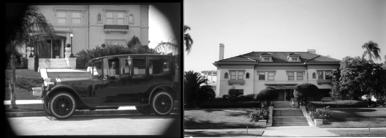
55 Fremont Place in The Kid. This beautiful home, once owned by prize-fighter Muhammad Ali, stands across the street from 56 Fremont Place, the former Mary Pickford home appearing in The Artist.
Across the street from Mary Pickford’s house is the mansion where Edna Purviance abandons her infant son (see above) at the beginning of Charlie Chaplin’s The Kid (1921).
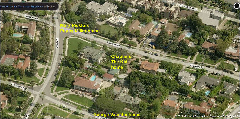
(c) 2011 Microsoft Corporation, Pictometry Bird’s Eye (c) 2010 Pictometry International Corp.
The mansion where George Valentine lives is located at 104 Fremont Place (see above), behind the home Chaplin used when filming The Kid and close to Mary Pickford’s home.�� Read more about the Fremont Place neighborhood HERE.
Buster Keaton’s One Week

The Lillian Way entrance to the Red Studios was fixed up to appear in the movie. The red box marks the same sliding door and shed in both images. The left yellow oval marks the shadow cast by the modern day rooftop air-conditioning unit (the right yellow oval), replaced with open sky in the movie frame. The Cahuenga entrance to the Red Studios on Cahuenga was used in Who Framed Roger Rabbit ? (c) 2011 Google.
 The studio entrance gate and other exterior studio scenes portrayed in The Artist were filmed at the Red Studios, 846 N. Cahuenga Boulevard, two blocks due south from the site of the former Buster Keaton Studios.�� The block where the Red Studios is situated was used as a backlot for the Metro Studios to build exterior sets.���� It was here that Buster Keaton constructed his disastrous build-it-yourself two-story home (left) for his debut independent short film One Week (1920).�� To see vintage aerial photos of the backlot where Keaton filmed One Week, and how the Red Studios portrayed the Maroon Cartoon Studio in Who Framed Roger Rabbit?, you can read more HERE.
Harold Lloyd’s Safety Last!
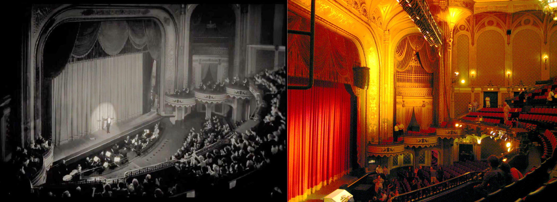
George Valentin, portrayed by Jean Dujardin, takes a bow on the Orpheum Theater stage. Color image by Kara Brugman; http://www.flickr.com/photos/hyperbolation/2675673050/
The triumphant 1927 premiere of George Valentin���s hit movie A Russian Affair was staged inside the historic Orpheum Theater, located in the heart of the Los Angeles Historic Core, at 842 S. Broadway.
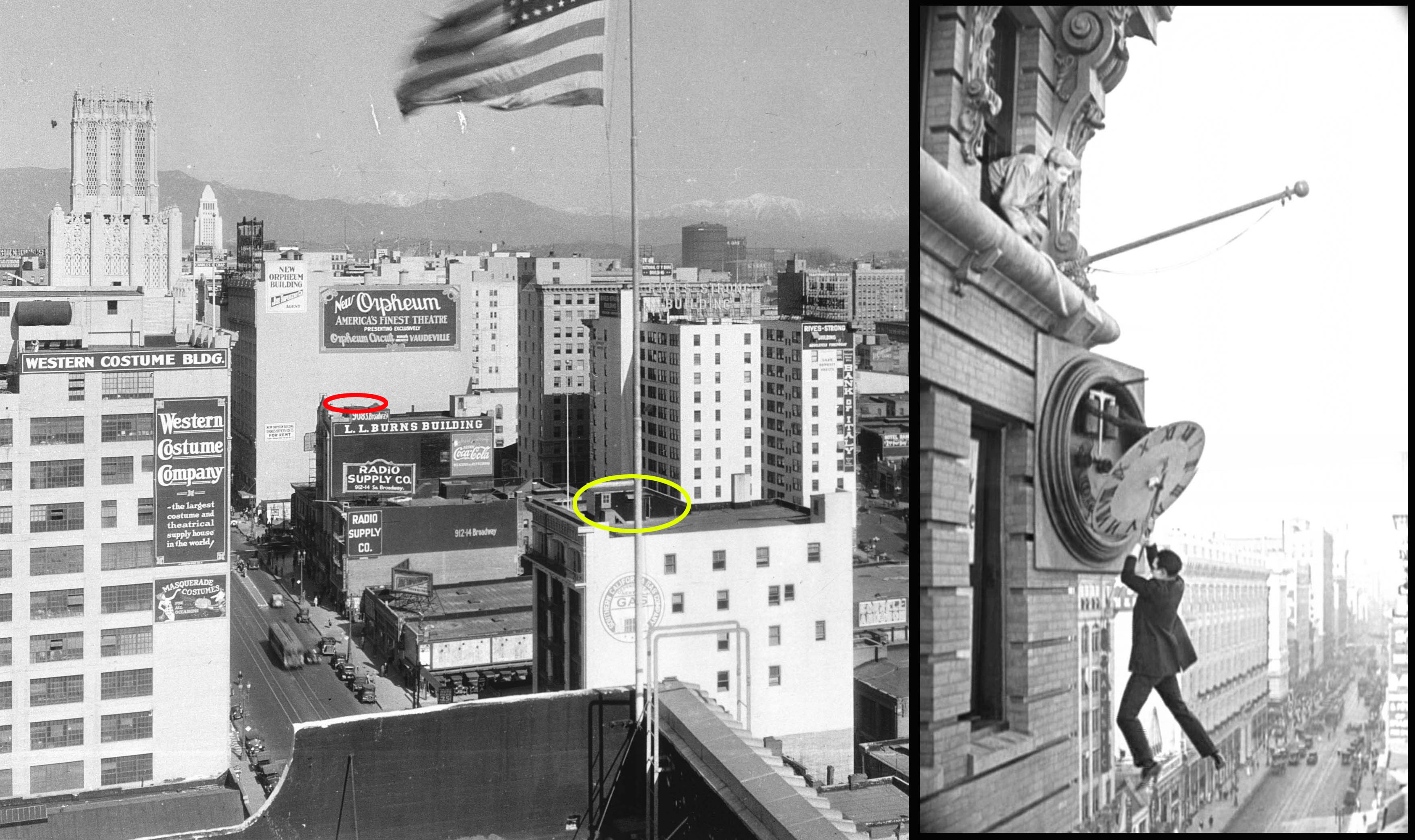
This circa 1928 photo looks up Broadway from Tenth Street (now Olympic). The newly completed Los Angeles City Hall appears as the white tower in the far background. Harold Lloyd filmed the clock stunt from Safety Last! (1923) on the roof to 908 S. Broadway (red oval above), just steps away from the Orpheum Theater that opened in 1926. Today the Art Deco Ninth and Broadway Building, completed in 1930, obscures the painted Orpheum Theater wall sign. The yellow oval marks where Lloyd returned to film climbing stunts for Feet First (1930).�� USC Digital Library.
As shown above, the Orpheum Theater stands just a few steps north from where Harold Lloyd staged his clock climbing stunt from Safety Last! (1923).�� You can read more about the Orpheum Theater HERE and many posts about Safety Last! HERE.
Present Day Backlots and Uggie
My other posts show a variety of The Artist filming locations not reported elsewhere, including scenes where Uggie the dog comes to the rescue, where Peppy comes to the rescue, and how the present day Warner Bros. and Paramount Studios backlots were used to replicate silent-era Hollywood.
The Paramount backlot – color image J. Eric Lnyxwiler
The Los Angeles Times reports some locales appearing in The Artist, as does Lindsay Blake���s ImNotAStalker.Com; including George���s duplex apartment; the history of the Red Studios where much of The Artist was filmed; and of the AFI ���hospital��� and the Wilshire Ebell where many interior scenes were filmed. The Wilshire Ebell Theater, at 743 Lucerne Boulevard, is also just steps away from the Mary Pickford home on Fremont Place.
The Artist (C) La Petite Reine, The Weinstein Company.�� All images from Chaplin films made from 1918 onwards, copyright �� Roy Export Company Establishment. CHARLES CHAPLIN, CHAPLIN, and the LITTLE TRAMP, photographs from and the names of Mr. Chaplin���s films are trademarks and/or service marks of Bubbles Incorporated SA and/or Roy Export Company Establishment. HAROLD LLOYD images and the names of Mr. Lloyd���s films are all trademarks and/or service marks of Harold Lloyd Entertainment Inc. Images and movie frame images reproduced courtesy of The Harold Lloyd Trust and Harold Lloyd Entertainment Inc. One Week licensed by Douris UK, Ltd. Used with permission.
Filed under: Buster Keaton, Charlie Chaplin, Harold Lloyd, Mary Pickford, The Artist Tagged: Buster Keaton, Charlie Chaplin, City Lights, Harold Lloyd, Hollywood, One Week, Safety Last!, Silent Comedians, Silent Comedies, Silent Movie Locations, Silent Movies, the artist filming locations, The Artist locations, The Kid, then and now, Who Framed Roger Rabbit?

January 31, 2015
How Laurel and Hardy Filmed Another Fine Mess

Click to enlarge each image.�� Stan and Ollie (well, their stunt men) ride south down Sunset Blvd. from Grand at the conclusion of Another Fine Mess. Palmer Conner Collection.
In 2001 Piet Schreuders wrote to me from his home in Amsterdam postulating (correctly) about the tunnel appearing at the conclusion of Laurel and Hardy���s 1930 comedy short Another Fine Mess. Apart from being an internationally acclaimed graphic designer, and creator of Furore Magazine, Piet���s amazing list of accomplishments include writing The Beatles��� London, a guide to The Beatles��� shooting and filming locations; co-founding The Beau Hunks music ensemble, which recreates the LeRoy Shield musical scores played during the Hal Roach Studio comedies; and creating a virtual reality computer model of downtown Culver City as it appeared when Laurel and Hardy filmed there so frequently in the 1930s. Piet has also tracked down the filming locations for such classic French films as Mr. Hulot���s Holiday (1951) and The Red Balloon (1956).

The boys turn south from Sunset, past the Croyden Hotel Apartments, towards the north portal of the northern Hill Street Tunnel. Palmer Conner Collection.
Another Fine Mess is a remake of Stan and Ollie���s earlier film Duck Soup (1927), and the first movie to use the background music of Piet���s hero Mr. Shield. The story begins as the Boys hide from the police in what they believe is a deserted mansion.

Stan Laurel’s solo appearance beside the mansion in White Wings (1923) – the mansion at 3500 W. Adams – Stan and Ollie dressed as a goat fleeing the home in Another Fine Mess. LAPL.
The mansion appearing in the film, still standing at 3500 West Adams Blvd., was built by in 1910 by Secondo Gausti, and was later owned by film choreographer Busby Berkeley. The mansion is now home to the Peace Awareness Labyrinth & Gardens and is open for tours.
The movie concludes with a cartoon-style joke. Stan and Ollie flee the mansion dressed in a two-person goat costume (don���t ask), then quickly commandeer a tandem bicycle. The police chase the bicycling duo into a tunnel when a trolley approaches. The speeding trolley car strips the police of their clothing, while Stan and Ollie emerge from the other end of the tunnel relatively unscathed, but now riding unicycles, suggesting their tandem bike was torn in two.

The Boys pass a distinctive billboard for Mt. Lowe as they continue towards the northern Hill Street Tunnel portal. Palmer Conner Collection.
Piet wrote to me with an enticing anecdote from Randy Skretvedt���s classic book ���Laurel and Hardy: The Magic Behind the Movies,��� where stunt person Joe Mole recalled that he and his brother rode the unicycles for the scene ���down by the old Hill Street tunnel.��� Based on the series of maps and other materials he provided, Piet correctly concluded that the scene must have been filmed where the Pacific Electric Railway veers south from Sunset into the tunnel running beneath Fort Moore Hill.

Views of the tunnel portal before and after it was closed over. Inset Mark Forer.

Click to enlarge.�� The north portal (top arrow) to the northern Hill Street Tunnel running from Sunset to Temple beneath Fort Moore Hill (dotted line).�� The bottom arrow points to the Broadway Tunnel north portal. LAPL.
Los Angeles was a very different place in 1930. Originally cut off to the northwest by a series of hills, downtown LA was difficult to reach from Hollywood and parts west until a series of tunnels were built starting in 1901. By 1930 a series of six tunnels provided access to downtown; the 3rd Street Tunnel, the Broadway Tunnel, the twin-bore Hill Street Tunnel under Court Hill, the single-bore northern Hill Street Tunnel under Fort Moore Hill, the 2nd Street Tunnel, and the Hollywood subway tunnel running from Beverly/Glendale Boulevards south of Echo Park into the basement of the Subway Terminal Building. Although there were 11 tunnel portals to choose from, given the layout and other characteristics present during the scene, I agreed with Piet���s conclusion. But at the time there were so few reference photos available it was difficult to sense what the area looked like.

Harold Lloyd and the Mt. LOW_ RAPID Electric
One thing that struck me watching the scene is that Stan and Ollie pass a billboard advertising the Pacific Electric railway to Mt. Lowe. Mt. Lowe had been on my radar ever since I became aware that Harold Lloyd once modified a trolley advertisement appearing in Hot Water (1924) to read ���Mt. Low_��� on the ���RAPID Electric.��� It’s baffling why Lloyd bothered to revise the Pacific Electric ad, but then only alter it slightly, and so this oddity was something I always remembered.

A closer view, riding south down Sunset from Grand (top arrow) then turning right towards the tunnel (bottom arrow).
Since 2001 a great many vintage photos have become available for online searching, and one particularly exciting collection is the Palmer Conner Collection of Color Slides of Los Angeles hosted by the Huntington Digital Library. While browsing the collection I noticed a billboard advertising Mt. Lowe. Remembering the Laurel and Hardy billboard, I pulled up the movie frame and found it was a match, confirming the tandem bike entered from Sunset Boulevard into the north portal of the northern Hill Street Tunnel. Likewise, comporting with geographic reality, the unicycles were filmed emerging from south portal of the tunnel, riding towards Temple Street.

Another view of the northern Hill Street Tunnel (dotted line) running from Sunset to Temple. The Boys entered at the Sunset portal (arrow). After the trolley tracks crossed Temple they continued on Hill Street under Court Hill (yellow box). USC Digital Library.
The tunnel ran diagonally SE beneath Fort Moore Hill roughly from Sunset and Grand to Temple and Hill, passing underneath the playground of the Los Angeles High School. For decades after the tunnel was taken from service, and the portals sealed, a central section of the tunnel was used for storage by the Los Angeles Unified School District. This lasted until 2004, when construction of the current Los Angeles High School No. 9 on Fort Moore Hill necessitated filling in the remaining stretch of the tunnel.

The Boys exit the southern portal riding towards Temple Street.
For more locations earlier in the film (below), Steven J. Margaretic has posted photos of the Boys filming along West Adams in front of the mansion, and riding their tandem bicycle north on 5th Avenue crossing 25th Street, a block from the mansion.

Other locations from Another Fine Mess identified by Stephen J. Margaretic at ClassicVideoStreams.com.
 You can purchase Piet’s wonderful study of Laurel and Hardy filming on Main Street in Culver City, complete with street view maps and diagrams, together with fascinating articles about LeRoy Shield and other topics, at his website, HERE.�� You can purchase Piet’s meticulous study of the Paris

Piet Schreuder’s amazing map of Court Hill, the area within the yellow box three images up.
locations appearing in The Red Balloon, HERE, and can purchase his Beatles guide to London HERE.�� In closing, I also want to thank Piet for the remarkably informative 3D aerial maps that he contributed to my Harold Lloyd book Silent Traces that depict some of LA’s long lost neighborhoods. These elegant illustrations provide clarity and context to those seeking their way into the past.�� Thank you Piet for your beautiful work.
Check out Piet’s virtual reality model of 1930s Culver City here.
Another Fine Mess (C) Hal Roach Studios, Inc.�� HAROLD LLOYD images and the names of Mr. Lloyd���s films are all trademarks and/or service marks of Harold Lloyd Entertainment Inc. Images and movie frame images reproduced courtesy of The Harold Lloyd Trust and Harold Lloyd Entertainment Inc.
Site of the former tunnel portal today
Filed under: Laurel and Hardy, Los Angeles Tunnels Tagged: Another Fine Mess, Fort Moore Hill, Hill Street Tunnel, Laurel and Hardy, Laurel and Hardy film locations, Los Angeles Tunnels, Subway Tunnel, then and now, White Wings

January 18, 2015
Mid City Views – How Hal Roach’s Taxi Boys filmed Taxi for Two

Then (1925) and Then (1932) – Super- Hooper-Dyne Lizzies (l) and Taxi for Two (r), both directed by Del Lord.
 The 1932 Hal Roach Studio comedy Taxi for Two provides a fascinating glimpse of early Washington Blvd., and the mid-city neighborhood that sprung up south of Hollywood halfway between Culver City and downtown Los Angeles. Directed by Del Lord, one of Mack Sennett’s top directors, Taxi for Two re-stages some of the classic visual gags and car stunts Lord had made famous working for the Keystone Studio in the 1920s.
 The highlight of the film comes when the Taxi Boys (Billy Gilbert and Ben Blue) run out of gas, and start pushing the rear of their taxicab blindly forward. The men are so intently focused on their task that they don’t notice when they push their cab into the rear of another vehicle, and continue forward pushing both cars. The boys soon push the two cars into a third vehicle, adding it to the chain, and then a fourth car, until finally a stalled trolley car joins the mix. The image of Billy and Ben pushing an undulating train of autos and trolleys down a city street recalls the Sisyphean image of Billy Bevan pushing a similar train of cars (above, right) in the Del Lord-directed Keystone comedy Super-Hooper-Dyne Lizzies (1925) (available as part of The Mack Sennett Collection, Vol. One from Flicker Alley).

Click to enlarge each image. Looking east down Washington Blvd. toward the corner of West View Street.
I found the many locations from Taxi for Two by first noticing a sign for the Beacon Market appearing in the background, above. Although I couldn’t find such a market in the online City Directories at the Los Angeles Public Library, I did find a newspaper story in the library’s online Los Angeles Times newspaper archive that placed the market at the corner of W. Washington Blvd. and S. Rimpau Blvd.

Looking east towards 4748 W. Washington Blvd. from Rimpau.
Once I had my bearings, I poked around the area using Google Street View and found the other filming spots along Washington Blvd.

4818 W. Washington Blvd. just east of West View Street.

Looking east towards the Union Public Market at the SE corner of W. Washington Blvd. and West View Street.

The caravan turns right from Washington Blvd. on to West View Street, beside The Citizens National Trust and Savings Bank (now the site of a nursing home), a small architectural gem that once stood on the SW corner. USC Digital Library.
I found the remaining locations, again, by snooping around adjacent streets on Google Street View. My big break came when I noticed that West View Street (pictured above looking north) seemed to drop off below grade, as if Washington Blvd. ran along a hill. So I searched the steep hills situated north of Washington Blvd. until I found the remaining shots.

Ben and Billy run down steep Pickford Street towards Rimpau, steps away from Washington Blvd. The oval marks the back entrance way to 4175 Mascot Street appearing in both images.

4710 Pickford Street (a temporary structure has been added above the garage).
The first car stunts, where Billy and Ben chase the cars, were filmed on Pickford Street, a very steep hill just steps from Washington Blvd. where the earlier commercial street scenes were filmed. The later car stunts, where Billy and Ben dodge the cars, were filmed a few blocks further north on W. 17th St. at S. Rimpau Blvd., where the hill was less steep, and presumably safer for the actors. The director helped to disguise the shift in streets by showing only the south side of Pickford and the north side of 17th. The concluding scenes were filmed at 17th and Rimpau as well.

The remaining stunts were performed on nearby W. 17th St., which was less steep. The duplex at 4723-4725 appears to the upper left.

Ben and Billy prepare to dodge the speeding cars. Behind them is the corner of S. Rimpau and W. 17th St.

Looking towards the NE corner of S. Rimpau (l) and W. 17th St. (r).

The taxi comes to rest between 4813 and 4807 W. 17th St.

4813 W. 17th St. appears behind Ben in this reaction shot.

The detached garage to 4807 W. 17th St.
You can read about how three other Taxi Boys shorts solved a Laurel & Hardy filming location mystery at this post HERE.
Taxi for Two (C) 1932 Hal Roach Studios, Inc. Color image 4818 W. Washington Blvd. (C) 2014 Microsoft Corporation, all other color images (C) 2014 Google.
Filed under: Hal Roach Studios Tagged: Ben Blue, Billy Gilbert, Hal Roach, Hal Roach Studios, Taxi Boys, Taxi for Two, then and now, Washington Boulevard

Mid City Views ��� How Hal Roach���s Taxi Boys filmed Taxi for Two
Then (1925) and Then (1932) - Super- Hooper-Dyne Lizzies (l) and Taxi for Two (r), both directed by Del Lord.
The 1932 Hal Roach Studio comedy Taxi for Two provides a fascinating glimpse of early Washington Blvd., and the mid-city neighborhood that sprung up south of Hollywood halfway between Culver City and downtown Los Angeles. Directed by Del Lord, one of Mack Sennett���s top directors, Taxi for Two re-stages some of the classic visual gags and car stunts Lord had made famous working for the Keystone Studio in the 1920s.
The highlight of the film comes when the Taxi Boys (Billy Gilbert and Ben Blue) run out of gas, and start pushing the rear of their taxicab blindly forward. The men are so intently focused on their task that they don���t notice when they push their cab into the rear of another vehicle, and continue forward pushing both cars. The boys soon push the two cars into a third vehicle, adding it to the chain, and then a fourth car, until finally a stalled trolley car joins the mix. The image of Billy and Ben pushing an undulating train of autos and trolleys down a city street recalls the Sisyphean image of Billy Bevan pushing a similar train of cars (above, right) in the Del Lord-directed Keystone comedy Super-Hooper-Dyne Lizzies (1925) (available as part of The Mack Sennett Collection, Vol. One from Flicker Alley).
Click to enlarge each image. Looking east down Washington Blvd. toward the corner of West View Street.
I found the many locations from Taxi for Two by first noticing a sign for the Beacon Market appearing in the background, above.�� Although I couldn’t find such a market in the online City Directories at the Los Angeles Public Library, I did find a newspaper story in the library’s online Los Angeles Times newspaper archive that placed the market at the corner of W. Washington Blvd. and S. Rimpau Blvd.
Looking east towards 4748 W. Washington Blvd. from Rimpau.
Once I had my bearings, I poked around the area using Google Street View and found the other filming spots along Washington Blvd.
4818 W. Washington Blvd. just east of West View Street.
Looking east towards the Union Public Market at the SE corner of W. Washington Blvd. and West View Street.
The caravan turns right from Washington Blvd. on to West View Street, beside The Citizens National Trust and Savings Bank (now the site of a nursing home), a small architectural gem that once stood on the SW corner.�� USC Digital Library.
I found the remaining locations, again, by snooping around adjacent streets on Google Street View.�� My big break came when I noticed that West View Street (pictured above looking north) seemed to drop off below grade, as if Washington Blvd. ran along a hill.�� So I searched the steep hills situated north of Washington Blvd. until I found the remaining shots.
Ben and Billy run down steep Pickford Street towards Rimpau, steps away from Washington Blvd.�� The oval marks the back entrance way to 4175 Mascot Street appearing in both images.
4710 Pickford Street (a temporary structure has been added above the garage).
The first car stunts, where Billy and Ben chase the cars, were filmed on Pickford Street, a very steep hill just steps from Washington Blvd. where the earlier commercial street scenes were filmed. The later car stunts, where Billy and Ben dodge the cars, were filmed a few blocks further north on W. 17th St. at S. Rimpau Blvd., where the hill was less steep, and presumably safer for the actors. The director helped to disguise the shift in streets by showing only the south side of Pickford and the north side of 17th. The concluding scenes were filmed at 17th and Rimpau as well.
The remaining stunts were performed on nearby W. 17th St., which was less steep. The duplex at 4723-4725 appears to the upper left.
Ben and Billy prepare to dodge the speeding cars.�� Behind them is the corner of S. Rimpau and W. 17th St.
Looking towards the NE corner of S. Rimpau (l) and W. 17th St. (r).
The taxi comes to rest between 4813 and 4807 W. 17th St.
4813 W. 17th St. appears behind Ben in this reaction shot.
The detached garage to 4807 W. 17th St.
You can read about how three other Taxi Boys shorts solved a Laurel & Hardy filming location mystery at this post HERE.
Taxi for Two (C) 1932 Hal Roach Studios, Inc.�� Color image 4818 W. Washington Blvd. (C) 2014 Microsoft Corporation, all other color images (C) 2014 Google.
View Larger Map
View Larger Map
Filed under: Hal Roach Studios Tagged: Ben Blue, Billy Gilbert, Hal Roach, Hal Roach Studios, Taxi Boys, Taxi for Two, then and now, Washington Boulevard
December 30, 2014
Even More Speedy – New York Locations

During Speedy Harold Lloyd chases after his errant taxi by jumping on a passing car in front of 339 E. 57th St in New York. The four identical apartments to the east are now all lost to much taller buildings.
Harold Lloyd’s final silent comedy Speedy, filmed on location in New York during the summer of 1927, is a goldmine of vintage Manhattan locations. While my book Silent Visions devotes 100 pages to the dozens of NYC (and Los Angeles) appearances in the film, and my other posts cover Speedy in great detail, there always seems to be one more setting awaiting discovery.

Momentarily stunned, Harold watches his taxi being towed east down E. 57th St. towards 1st Ave. Of the long row of five identical apartments depicted in the topmost image, only 339 E. 57th St. survives.
Harold’s first day as a taxi driver is a complete disaster. His troubles begin when he mistakes a construction site supervisor, waving to a land surveyor, as a customer flagging down a cab (below). As Harold pulls over beside the active construction site, a painted wall at back advertises a number of 4-6-7 room apartments that will become available. Try as I might, this setting eluded my detection, but that 4-6-7 wall sign stayed with me.

Looking to the NE, Harold parks beside the construction site for the 410 E. 57th St. apartments. The Williamsburg (59th St.) Bridge appears at back.
I recently had the honor of spending a few hours looking through the Harold Lloyd film storage vault, studying the photos on file. Aside from the thousands of 8×10 publicity stills taken to promote his films, Harold’s team also took a number of smaller 4×5 glass negatives, some candid shots, some location shots, to assist with production issues. Although I only had time to glance at a few of these 4×5 negatives, by complete chance I pulled a slide that had a 4-6-7 sign painted on a wall. When my friend Richard Simonton arranged to send me a “positive” scan of the shot, I could instantly see that this was the setting where Harold filmed. What’s more, the image revealed the future apartment’s complete address, 410 E. 57th St.

Helping a customer with his luggage in front of the 410 construction site, Harold at first does not notice his cab being towed away. The red lines in each image above depict the same buildings along 419-433 E. 57th.
 I had hoped to solve this mystery early on by focusing on the modest scale Corn Exchange Bank branch visible on the SW corner of 1st Avenue and E. 57th St. during the scene (see left), but the bank once had twenty or more offices around New York, and so many Manhattan corner properties have since been upgraded that the spot eluded detection. A modern Chase Bank branch stands at the spot today.

As Harold chases after his cab, his customer notices that the bottles of illegal booze hidden in his valise are now broken. The red box marks the same extant buildings in each image.
 The world depicted by Speedy does not match geographic reality. Harold first chases after his taxi by running east along E. 57th St, from 1st Ave. Yet in the next shot (see left) he chases his taxi by jumping on a car going east along E. 57th St. towards 1st Ave. (see scenes at the top of this post). Thus, this later shot (left) looks east towards the prior spot where Harold filmed, revealing common details as shown below.

The same apartment for rent sign appears in both movie shots.

The movie frame looking east towards 1st Ave. also captures the apartment awnings appearing in the still photo.

The view looking east towards 1st Ave. shows the same short building standing on the NE corner of E. 57th St. A tall modern apartment in the color view (X) stands where shorter buildings once stood.
The scene with Harold chasing after his taxi continues with a sequence filmed in Los Angeles (!) looking towards the Mayfair Hotel where scenes from the noir thriller Edge of Doom (1950) and the hit television comedy The Office were filmed. You can read more about this location at this post HERE.

Harold’s chase after his taxi continues next in downtown Los Angeles! You can read about it HERE.
With this latest discovery on E. 57th St, fewer and fewer locations from Speedy remain undetected.
HAROLD LLOYD images and the names of Mr. Lloyd’s films are all trademarks and/or service marks of Harold Lloyd Entertainment Inc. Images and movie frame images reproduced courtesy of The Harold Lloyd Trust and Harold Lloyd Entertainment Inc. Color images (C) 2014 Google.
View Larger Map
Filed under: Harold Lloyd, Manhattan, Speedy Tagged: Edge of Doom, Harold Lloyd, Manhattan, Mayfair Hotel, Silent Comedians, Silent Comedies, Silent Movie Locations, Silent Movies, Speedy, The Office, The Office locations, then and now

November 30, 2014
The Big Parade – Historic Views of the Home Front

Small-town America (Orange, Calif.) swept up with patriotic fervor – The Big Parade.
 Although most of The Big Parade (1925) is set in the war-torn villages and battlefields of France, the acclaimed World War I drama also provides historic views of early downtown Los Angeles and Orange County. Told from the soldier’s point of view, the epic movie directed by King Vidor follows a trio of men from different walks of life brought together by combat.
Set in the Spring of 1917, the movie intertitles describe America then as a nation occupied in peaceful progression. Mills were humming with activity while buildings climbed skyward, monuments to commerce and progression.

America’s buildings climbing skyward – the extant Barker Brothers Building at 7th and Flower. LAPL.
 The three male leads are introduced by their professions. Construction worker “Slim” (Karl Dane) is one of labor’s millions, building a nation, Bowery saloon-keeper “Bull” (Tom O’Brien) is a man of another trade, while idle “rich man’s son” James Apperson (John Gilbert) scoffs at ever taking over the helms of his father’s mill. Together these unlikely friends bond through the horrors of war.

Slim (Karl Dane) at work beside the Hall of Justice.

The effect of Slim working high in the air was created by building a simple construction set overlooking the south portal of the former Broadway Tunnel. The star marks where the set stood. USC Digital Library.
The effect of Karl Dane working high in the air was created by building a simple construction set on the terrace overlooking the south portal of the Broadway Tunnel. The camera captured the city streets far below in the background, but cut off the bottom of the set standing on the terrace. This technique was used repeatedly during the silent era, especially for stunt climbing comedies. At the time downtown Los Angeles had five major tunnels; the “upper” Hill Street Tunnel that ran under Fort Moore Hill between Temple and Sunset, the “lower” Hill Street Tunnel that ran under Court Hill between 1st and Temple, the 2nd Street Tunnel, the 3rd Street Tunnel alongside the Angel’s Flight incline railway, and the Broadway Tunnel that also ran under Fort Moore Hill from between California Street (near Temple) and Sunset, as shown here. The south portal of the Hill Street Tunnel is where Harold Lloyd filmed three of his stunt comedies, as described in this post. Other posts shows how the tunnels are situated to each other, and how they fit in with film noir classics such as Criss Cross (1949). The Broadway Tunnel was demolished in the 1950s. Only the 2nd Street and 3rd Street Tunnels remain.

This 1940 model of downtown Los Angeles on display at the Natural History Museum shows the view from the former Broadway Tunnel overlook towards the Hall of Records Building (arrow), now demolished. The star marks where Karl’s construction site set was built.
 The movie kicks into gear when John Gilbert’s character James witnesses a parade around his home town square. Caught up in the fervor, tapping his feet to the militaristic music, John is easily persuaded to enlist by a group of his enthusiastic friends. The parade scenes were filmed in the heart of Orange County at Plaza Square in Orange, California, marking the intersection of Glassell Street and Chapman Avenue, named for the two founders of the city.

John Gilbert drives west on Chapman Avenue towards Plaza Square. At back is the Odd Fellows hall under construction at the NE corner of Chapman and Orange. The yellow box marks the upper floor balcony. The red box shows the corner of the former First Christian Church, discussed further below, that once stood on the SE corner of Grand and Chapman.

An aerial view of Plaza Square. John Gilbert drives west along E. Chapman Avenue, top arrow, and stops at the oval. The other arrows show the fields on view presented in the movie. The corner of the former First Christian Church (red box) appears in the movie frame above. LAPL.

A view towards the Dittmer’s Mission Pharmacy building. The building once had a circular corner tower that was removed when the building was upgraded with an Art Deco style. The side window patterns remain unchanged.

This elaborate fountain once stood at the center of Plaza Square. It appears behind the drummer in this shot. The fountain has since been relocated to the NW corner of the Orange Public Library. USC Digital Library.

John Gilbert beside the former bank building at 107 E. Chapman Avenue. A more modern bank building stands at this corner today. Orange Public Library and History Center.
The Big Parade would prove to be one of the biggest hits of the silent-film era. Although remembered for humanizing the tragedy of war, it also preserves a bit of Southern California history as well.

Inspired by his buddies, John Gilbert decides to enlist – The Big Parade.
For more images of the square you can visit Nathan Masters’s post How the City of Orange Circled Its Towne Square. The Big Parade (C) 1925 Metro-Goldwyn-Mayer. Color street images (C) 2014 Google.
View Larger Map
Filed under: Uncategorized Tagged: Barker Brothers Building, Broadway Tunnel, Chapman, Glassell, John Gilbert, Karl Dane, King Vidor, Los Angeles Historic Core, Orange California, Silent Movie Locations, Silent Movies, The Big Parade, then and now


