
 Theodore’s
Comments
(group member since Apr 01, 2017)
Theodore’s
Comments
(group member since Apr 01, 2017)
Theodore’s
comments
from the Navigating Indieworld Discussing All Things Indie group.
Showing 941-960 of 1,449
 Carole wrote: "Thanks ted"
I don't think Jose would be a problem for LI...but further north, it could be a concern.
Hurricane Update from my weather forecasting neighbor...you in the NE US...pay attention...Hurricane Irma is currently moving just north of west along the north coast of Cuba. With much of its circulation over land, the maximum winds have decreased to around 130 mph, a strong Cat 3. The models continue to forecast a turn to the northwest and then north northwest taking it over the Straits of Florida. Although there is some wind shear, the water is warm so there will likely be some strengthening to return Irma to a Cat 4 at landfall, which now looks to be in the western Keys near Key West early Sunday morning. With most models forecasting a continued north northwestward movement along the west coast of Florida the most vulnerable areas for dangerous storm surge flooding and very high winds should be from the Keys northward to Marco Island, Naples and Sanibel. It looks like Miami may now escape the eastern eye wall, which has the strongest winds, but Irma will have a powerful northeast quadrant which should still bring strong damaging onshore hurricane force winds and a storm surge to SE Florida, including Miami. Irma may still have hurricane force winds when it reaches the FL/GA border sometime Monday afternoon.
There is another strong hurricane, i.e., Jose, which at last report has maximum winds of 145 mph. It appears that Jose will turn northward in the Atlantic before it reaches the Leeward Islands. If one likes to speculate at the limit of predictability, at least one numerical weather prediction model has a 10 day forecast of Jose interacting with an extratropical trough causing some stormy weather in eastern New England. Stay tuned.
Going to the west side:app-facebook
Mike's Weather Page
3 minutes ago
Latest GFS from tropicaltidbits.com going west. It appears the trend is set... now how much more west we will see. Irma has competed an eyewall cycle so lots to watch on strength. Will Cuba and shear help restrict... hottest water yet ahead. New EURO 2pm. www.spaghettimodels.com / Mikes Weather Page APP
NHC 11am update. Nudge west. Expected CAT 4 at landfall and maintaining hurricane strength towards FL/GA line. Whole Florida peninsula STILL IN CONE. Hurricane Watches/Warnings extended north on both coasts. It all comes down to WHEN she turns north as to who gets the worst. Everyone in the Peninsula will get something. Keep up with everything you need on Irma at www.spaghettimodels.com / Mikes Weather Page APP / LIVE updates at www.spaghettimodels.com/irma
Again...the sites to watch are:http://spaghettimodels.com/
https://www.cyclocane.com/irma-storm-...
000
WTNT61 KNHC 070800
TCUAT1
Hurricane Irma Tropical Cyclone Update
NWS National Hurricane Center Miami FL AL112017
0400 AM AST Wed Sep 07 2017
...0400 AM AST POSITION UPDATE...
...IRMA PASSING TO THE NORTH OF THE EASTERN DOMINICAN REPUBLIC...
SUMMARY OF 0400 AM AST...0800 UTC...INFORMATION
----------------------------------------------
LOCATION...19.8N 68.1W
ABOUT 225 MI...365 KM ESE OF GRAND TURK ISLAND
MAXIMUM SUSTAINED WINDS...180 MPH...290 KM/H
PRESENT MOVEMENT...WNW OR 290 DEGREES AT 16 MPH...26 KM/H
MINIMUM CENTRAL PRESSURE...921 MB...27.20 INCHES
Two major hurricane-predicting tools show Hurricane Irma heading toward Florida — but one forecast is worse than the other.The Global Forecasting System, the main US tool, shows the center of Irma hitting along Florida's east coast.
But the European system — run by the European Centre for Medium-Range Weather Forecasts — shows Irma hitting a little further to the west, severely impacting the whole state. (Check out that version on the lefthand side of the photo up top.)
Basically, the American system shows a bad hurricane. The European tool predicts a total catastrophe.
CNN
Update from my friend, a professional meteorologist:Hurricane Irma Update
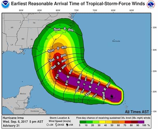
As of 10 PM today, Wednesday, Sep 6, Hurricane Irma has remained a Cat 5 storm for over 1.5 days with sustained winds of 185 mph in the northern eye wall, with hurricane force winds (>75mph) extending out about 50mi from the center and tropical force winds (>35mph) extending about 180 miles from the center. Early reports show devastating damage in the northern Leeward Islands and Irma will look to have a severe impact on the southern Bahamas Friday. Despite the numerical models indicating a bit more eastward track, Irma remains a serious threat to have a significant impact in Florida, particularly the SSE areas from Key Largo to around Miami on Sunday, as it should still be a Cat 4 hurricane at that time (max winds of >130mph) with significant storm surge potential. After that a probable forecast track appears to be close to but just east of the Florida coast and making a final landfall near the S. Carolina / Georgia border sometime Monday afternoon. My disclaimer is that these longer forecast times are still 3-5 days out, when even the best hurricane forecast projections often have track errors of 50 - 100 miles. I will keep you posted.
 Here's the storm tracker page for Irma:
https://www.cyclocane.com/irma-storm-...
Jose looks like it's going to turn north well before reaching the US while the new one in the Gulf appears to be headed across Mexico.
Carole wrote: "He sells to books sellers and libraries."Moi? Don't I wish. They may be buying wholesale from Amazon, but book sellers and libraries? In my dreams (though to my surprise, someone locally did ask the library here to purchase one of my books. Progress!)
app-facebookMike's Weather Page
36 minutes ago
Latest 12z GFS from tropicaltidbits.com. Flip-floping back to the west some. Skirts whole east coast of FL this time heading towards GA/SC. Still showing a deepening system near the Bahamas. Still showing possible expansion. Expecting EURO to trend close to this and maybe a tad bit more west. We will see soon. And yes that is Jose following behind. Will he influence his big sister is my question. www.spaghettimodels.com / Mikes Weather Page APP
Eldon wrote: "Theodore wrote: "This article just popped up on Indies Unlimited:http://www.indiesunlimited.com/2017/0...
It discusses options available for publis..."
Years ago I (and one other author) published a book that was brought out in paperback, and the publisher presented us with hardbound copies to celebrate the release. It was a nice gift.
Eldon wrote: "Congrats Ted!!Maybe a stupid question but... what is the NABE?"
Thanks, Eldon.
It's the National Association of Book Entrepreneurs.
Amy wrote: "Is there any indication it'll change course? My weather reports have these facts: Cat 5 hurricane. 185 mph. Current landfall is over Caribbean islands, destroying the most robust buildings. They'..."
Largest hurricane ever in the Atlantic Basin.
At this point, the models keep flipping back and forth across Florida, though the bias now seems to favor the east side (East Coast of the US)...very dangerous storm. As it approaches Key West, you can watch this live cam on Duvall Street:
http://www.liveduvalstreet.com/
Carole wrote: "Voted!!!!"Booyah! (;>)

Time to vote again, Guys and Gals...
http://www.indiesunlimited.com/2017/0...
This week I've submitted a conversation at a bar between two men discussing the love life of one of them. You will, I think, find what the other man has to say very interesting, given the week's literary "prompt."
Thanks for your support.
Ted (Theodore Jerome Cohen)
Theodore wrote: "Kimberly wrote: "R.L. wrote: "Me too Lyra. Where in Florida are you? They're saying Cat 6. I can't even concentrate in lecture right now"Now up to 185 mph.
Hurricane Irma now 185 mph. New EURO running. New NHC track at 5pm. 12z GFS ensembles clustering over Florida going straight north. When will she turn right is the million dollar question? Is she big enough now to do what she wants? Florida is under the gun first as far as the US goes. Timing starts going downhill Saturday into Sunday. Added new button under Irma tab in the APP to watch Live Mike videos. Also we have TS Jose behind. Her little brother wants to join the action. www.spaghettimodels.com / Mikes Weather Page APP
Kimberly wrote: "R.L. wrote: "Me too Lyra. Where in Florida are you? They're saying Cat 6. I can't even concentrate in lecture right now"Wow! Has it become a 6 already. Just this morning it was a 5! Still bad at ..."
There is no Cat. 6...Cat 5 is tops. These storms can only grow in intensity to a certain level based on their physics. But this one is a doozy, all right, and there's another one in its wake: Jose.
Theodore wrote: "Cat 5 Irma now with 175 mph winds. Spaghetti Models from tropicaltidbits.com show the gradual shift to the west overnight. It is important to also show the EURO and GFS ensembles from weathernerds...."Now the strongest storm ever seen while in the Atlantic basin.
