
Esther Crain's Blog, page 17
July 21, 2024
The colorful ghost ad that brings to life a long-defunct New York appliance chain
Before Best Buy, before Circuit City, before the Wiz, and even before Crazy Eddie’s, there was Friendly Frost.

Never heard of Friendly Frost? I hadn’t either. Then I saw this wonderful two-story faded ad, which is still advertising appliance brands that no longer exist on the side of a graffiti-covered red brick warehouse at Fifth Avenue and 19th Street in Brooklyn.
I’m not sure when Friendly Frost got its start. But by 1951 the chain was operating seven stores in New York City and the surrounding metropolitan area.
Friendly Frost outlets popped up at 89-58 165th Street in Jamaica, Queens, on Hylan Boulevard in Staten Island, in the Bronx on Fordham Road and Grand Concourse, and on 86th Street and Fifth Avenue in Bay Ridge (hence the sign’s location).

Demand must have been strong in mid-20th century New York City for “television sets,” refrigerators, air conditioners, and “stereophonic music systems,” as the company called them in the 1950s and 1960s. By the 1970s, Friendly Frost expanded to 39 stores.
There’s something about top appliance chains that lead them to go belly up, and that’s what happened to Friendly Frost. A 1979 New York Times article noted that the chain had been “operating at a loss in recent years.”
Friendly Frost stops showing up in newspaper archives by the early 1980s. When the last outlet shut its doors I don’t know. But left behind is this stunning postwar relic of a building ad, a remnant of the company’s retail glory days.
[Photos: J. Sears]


July 19, 2024
Explore the beauty and backstory of Riverside Drive this weekend with Ephemeral New York!
Ephemeral New York has been inviting the public to join in on walking tours of historic Riverside Drive for a few years now, and tickets are still available for the upcoming tour this Sunday, July 21, at 1 p.m.

What makes a tour of Riverside Drive unlike any other in New York City? The Drive is one of Manhattan’s most scenic and dramatic avenues. It’s also a place of legend and mystery, especially during the Drive’s early decades in the Gilded Age.
Which mansion built in the early 1900s has a tunnel leading to the Hudson River? Who was the famous stage star who lived in a Beaux-Arts townhouse purchased by her rich and notorious paramour? Why is the Drive the only avenue that branches into a semi-private carriage road?

Which famous American writer came to a rock outcropping in Riverside Park every day to stare across the Hudson River? Who was the wealthy wife and mother so disturbed by tugboat horns on the riverfront that she formed a committee to suppress “unnecessary” noise?
This Sunday’s breezy and fun walking tour will explore these mysteries and many more on this former millionaire’s mile—once home to the city’s Gilded Age elite and still the site of surviving mansions and spectacular monuments.

The July 21 tour starts at 1 p.m. and operates through the New York Adventure Club. Click here for tickets! The weather looks cooler with bright sunshine—perfect Gotham walking weather.
If you can’t make it this weekend, a few tickets are still available for the next Sunday, July 28, which operates through Bowery Boys Walks. Get tickets for the Sunday July 28 tour here!
[Top image: MCNY, 1913, X2011.34.4400; second image: MCNY, 1905, F2011.33.73; third image: MCNY, 1910, F2011.33.67]
July 15, 2024
The changing social rules John Sloan captured in a Greenwich Village restaurant in 1912
Artist John Sloan enjoyed depicting the outside world of the Greenwich Village neighborhoods where he made his home and studio—painting women on rooftops, a flower vendor selling his wares, and a cat streaking across pristine snow in his apartment backyard, among others.

In 1912 he lent his talents to an indoor scene. Sloan lived on Perry Street at the time, and he was a frequent visitor of Renganeschi’s, an Italian restaurant inside an 1830s brick dwelling at 139 West Tenth Street.
Unlike many of the other Italian restaurants opening in the Village at the time, Renganeschi’s was described as “classier” but still “modestly priced,” according to Gerald W. McFarland’s Inside Greenwich Village.
“Renganeschi’s Saturday Night” came out of these visits. On the surface, it gives us three stylish women at a prime table, having drinks and seemingly enjoying one another’s company.
It’s an unremarkable scene, right? Not in the early 1900s. In the painting, Sloan is signaling something about the three friends and the changing social rules for women of the era.
“By showing the women celebrating a night out on the town, the artist emphasized their newfound freedom to socialize in public spaces without the need for male escorts,” states the website for Art Institute Chicago, which has the painting in their collection.
“Although he indicated their working-class status through their ‘unladylike’ gestures—legs wrapped around their chairs and pinkies flared in the air—Sloan did not cast judgment on the women’s relaxed behavior. His informal style and loose brushwork enliven this scene of urban leisure with a sense of immediacy and action.”
The 200-year-old brick holdout house hiding behind a restaurant supply sign on the Bowery
The Bowery is many things, but first and foremost it’s New York City’s oldest road. This former Native American footpath once spanned Manhattan from the Harlem River almost to the southern end of the island.

When the Dutch arrived in the 17th century, they used this dirt trail as a carriage drive so the burghers running New Amsterdam could tend to business downtown and then escape to the rural expanses of their bouweries, or farm estates.
These bouweries lined “Bowry Lane,” as it became known, for several miles. (Director-General Peter Stuyvesant’s bouwerie was in today’s East Village.)
After the British took control of the colony and renamed it New York, Bowry Lane became an increasingly shorter north-south route. Eventually it transformed into a broad, 1.5 mile road starting at Chatham Square and ending at Cooper Square on Fourth Street. It also lost the “Lane” part and was simply called the Bowery.

Fast forward to the early 19th century, when the growing city of New York (with a population of about 60,000) was expanding northward. Houses began to pop up on the Bowery—typically the Federal-style, three-story dwellings favored by merchants and tradespeople.
These stylish homes would be deemed small by today’s standards. But at the turn of the new century, they were considered roomy enough for a family, maybe a commercial storefront on the ground floor, and perhaps a servant or two living on the third floor with the dormer windows and brick chimney peeking out from the roof.
 The Bowery of the early 19th century, painted by William Chapel in the 1870s
Paving stones and gaslights soon arrived as well, enhancing the desirability of the houses on this residential, newly elite Bowery.
The Bowery is a street that’s constantly in transition, and it only took a few decades for the well-heeled residential Bowery of the early 1800s to transform into a bustling commercial thoroughfare of small shops, hotels, oyster houses, and a head-spinning variety of entertainment venues in Antebellum New York City.

Single-family dwellings began to disappear as the 19th century continued, with tenements replacing them in the honky-tonk Bowery of post-Civil War New York. It was now a place of revelry and cut-rate deals packed with beer gardens, cheap theaters, and concert saloons for a largely lower class and immigrant clientele.
The constant din of the elevated train, which went up in 1879, as well as day and night foot traffic, carriages, and streetcars underneath made the Bowery a place where no one would choose to live if they had other options. (Below, Bowery and Grand Streets by William Louis Sonntag in 1895.)

The Bowery took on a new identity in the 20th century. By now, hotels had been chopped up into flophouses and forgotten men queued up on breadlines. These Bowery bums, as they were called, passed time in the bars that shared the street with some remaining 19th century mission houses, like the Bowery Mission, which opened at its current site in 1902.
The elevated was finally removed in the 1950s, and wholesalers in the restaurant equipment and lighting trades became a heavier presence, along with a smattering of artists and writers seeking cheap spaces.
Somehow, amid all this change on the Bowery, a handful of early houses from the Bowery’s elite era managed to remain standing. One of these is the Federal-style survivor at 206 Bowery at Rivington Street. (Below, in 1940)

Incredibly, this little dwelling—just 16 feet and eight inches wide—has been on the Bowery since 1825, according to a report from the Landmarks Preservation Commission (LPC).
Who built this modest former beauty and resided here during the Bowery’s early decades? It depends on the historical source you consult.
According to the LPC report, the house was “a speculative investment associated with the family and heirs of the wealthy English-born leather merchant James Meinell.”

“At the time of its construction, the lower Bowery was a fashionable address for New York’s social elite and wealthy merchant class,” continued the LPC report. “Since its completion, however, this house has always had a commercial ground story, with the family of the commercial tenant originally residing upstairs.”
The first business to open here in 1826 was a shoe store owned by a Walter Keeler, per the LPC. James Cooper’s fancy goods store was next from 1839 to 1853. After that it served as the studio of an engraver, umbrella and parasol concern, cigar shop, millinery store, and then a jewelry business.
On the other hand, the Bowery Alliance & Neighbors preservation group has it that the first owner was a butcher named John Brown and his wife, Lydia. The lower Bowery in the 18th and early 19th century was adjacent to New York’s slaughterhouse district, and butchers were among the New Yorkers to move to the new residential stretch of the Bowery, according to Bowery Alliance.

Brown and his wife “operated John Brown’s Porterhouse, a tavern serving area butchers in the adjoining 208 Bowery, which before alterations looked very much like its intact neighbor,” states the Bowery Alliance.
In the 1930s and 1940s, 206 Bowery was the address of the Tri-City Barber School, states the LPC report; you can see the school in the fifth photo, from 1940. (Originally the Tri-Boro Barber School as captured by photographer Berenice Abbott in 1935 was at 264 Bowery, not 206.)
By the 1990s, the signage outside Number 206 indicates that the space became part of the Bowery’s restaurant supply district. But newspaper archives reveal allegations that a prostitution ring operated here. “The ring is suspected of holding the women captive in a Chinatown brothel at 206-208 Bowery,” Newsday reported in January 1995.

Thirty years later, different signage implies that 206 Bowery is a restaurant supply concern. Its neighbors have long since been altered, and the condition of the little holdout doesn’t look strong.
But if you happen to walk by, stop and imagine the house’s earliest years—when the Flemish bond brickwork was new and unpainted; when the view out those top floor dormer windows revealed the expanse of Manhattan to the east.
206 Bowery is about to turn 200 years old. Isn’t it time to celebrate this dwelling and similar Federal-style survivors across lower Manhattan?
[Third image: metmuseum.org; fourth image: A Plan of the City of New-York, 1775, via Barry Lawrene Ruderman Antique Maps; fifth image: NYC Department of Records & Information Services; sixth image: Wikipedia]
July 8, 2024
Deciphering the faded ads on a brick building along the Bowery
The only thing more delightful than coming across a faint faded advertisement on the side of a building is looking closely and realizing there might be two ads, one painted over the other.

This kind of signage is known as a palimpsest—writing that’s been altered or covered by fresher writing, with traces of the original still remaining.
This ad was spotted at one end of the Bowery near Chatham Square. “Turkish” can be clearly deciphered; this was an ad for a cigarette brand called Turkish Trophies, which were available to New Yorkers at least since the turn of the century.
Enticing ads in newspaper archives show that Turkish Trophies went “10 cents for 10,” and they were popular in the U.S. in the late 1800s.

But take a closer look at the ad, and you’ll see the word “for” in yellow, and then a little to the right “you” in capital letters of a different typeface. Meanwhile, the T for Trophies appears to have another letter over it, possibly a fancy script F.
That F is a giveaway for Fletcher’s Castoria, a laxative for children sold by Charles Henry Fletcher since 1871. Ads for this prune-flavored product appeared all of the city, and a few of them still exist. One appears in newsreel footage of the Brooklyn Bridge in 1899, which can give you an idea of how long this medicine has advertised itself on city buildings.
Other words seem to appear beside the side windows; one might be “have” under “you.” There also seems to be another word in yellow under “Turkish.” Studying the faded letters feels like decoding hieroglyphs.
Which ad came first, the Turkish Trophies or the Castoria? My guess is Castoria.
Searching for the Lower East Side corner saloon as seen in a 1930s street life painting
Reginald Marsh was a true street artist—painting colorful, exaggerated images of New York City’s commuters, lovers, barflies, sailors, bargain shoppers, Coney Island thrill seekers, and Bowery bums, mostly through the 1920s and 1940s.

His depictions of the urban masses—inspired by his study of the Great Masters of the Renaissance during a trip to Europe in 1925—conveyed the energy and excitement (and sometimes despair) of early 20th century life in Gotham.
Marsh tended to focus on crowds and not individuals, which is why one notable painting in particular seems out of step. “H. Dummeyer Bar & Grill” is the title of this undated work, likely from the 1930s or 1940s. It features a lone man leaning agains a fire alarm box outside a corner saloon.
There’s a John Sloan kind of solitude to the painting, which isn’t all that surprising considering that Sloan was Marsh’s instructor when Marsh took classes at the Art Students League on West 57th Street. (Below photo, Marsh sketching on 14th Street in 1941)

The saloon in the painting seems dreary, festooned with fraying American flags. The drab figure holding his overcoat could be a neighborhood local or a friend of Marsh’s—or perhaps one of the forgotten men dwelling in forgotten sections of the Depression-era city.
Uncovering the identity of the man seems like a fruitless endeavor. But what about the saloon? Discovering where H. Dummeyer Bar & Grill once served growlers of beer to thirsty workingmen extends a firmer sense of place to the painting.
Luckily Dummeyer is an uncommon name. A 1904 Sun article featured a saloon keeper named Henry Dummeyer whose establishment was located at 281 Cherry Street, between Rutgers and Jefferson Streets.

(The article explained that Dummeyer, along with other local bar owners, complained to police that three crooks posing as detectives demanded protection money from them—an interesting slice of life kind of story of its own.)
Other articles reference an H. Dummeyer who in 1893 lost a large black dog on Cherry and Jefferson Streets, and an H. Dummeyer who had his liquor store at 281 Cherry Street burglarized a year later.
When these articles appeared, this block on Cherry Street would have been part of a densely packed tenement neighborhood, close to the “lung block” between Cherry, Catherine, Market, Monroe Streets—so named for its high concentration of residents living with tuberculosis, according to the Tenement House Commission in 1903.

A saloon like the one in Marsh’s painting would not be out of place on Cherry Street near the East River waterfront in the early decades of the 20th century.
What I’d really like is a photo of Dummeyer’s, an image that offers a clearer sense of the real-life saloon and street corner in Marsh’s painting. The third photo in this post shows the intersection of Cherry Street looking east to Rutgers Street , and there’s a corner store that looks like a possible contender.
Unfortunately, the storefront in the photo, from 1937, has an obvious difference—there’s no fire escape on the upper floors of the building, as Marsh’s painting shows.

Could this corner storefront from 1933, seen in the fourth photo in this post, be Dummeyer’s? The American flag bunting lines up with Marsh’s depiction, as does the facade of the building and the fire escape.
Unfortunately, though the fire hydrant on the sidewalk matches up, there’s no fire alarm call box. The photo, from the New York Public Library, also has the location as Cherry and Catherine Streets.
So I turned to the circa-1940 tax photo collection, part of the archives from the NYC Department of Records & Information Services. After looking for a photo to correspond to 281 Cherry Street, this image, seen in the fifth photo in this post, appears—an abandoned storefront that doesn’t exactly line up with Marsh’s.

Finally, by searching for Jefferson Street, a faded image of a matching corner saloon appears (above). The fire escape, fire hydrant, fire call box—they all line up as Marsh’s painting depicts them. The photo itself is cloudy, making it hard to read the name on the window. (Click the image for a closer view.)
But I’m pretty certain it’s Dummeyer’s. True, he may have thrown in the towel and sold his building in 1911, the year one newspaper ran a small announcement of the sale of 277-281 Cherry Street.
But since Marsh put the saloon name in the title of his painting, it appears that Dummeyer soldiered on into the 1930s or 1940s. By that time, many of Cherry Street’s rundown tenements and commercial spaces were targeted for demolition under the city’s slum clearance initiative.
Today, this corner is home to two residential towers and a parking lot overlooking South Street. The neighborhood has been rechristened “Two Bridges.” The gritty saloon corner of Marsh’s Lower East Side exists only in faded photos, art museums, and the imagination.
[Top image: MOMA; second photo: Everett/Shutterstock.com via britannica.com; third photo: NYPL Digital Collections; fourth photo: NYPL Digital Collections; fifth photo: NYC Department of Records & Information Services; sixth photo: NYC Department of Records & Information Services]
July 1, 2024
All the colorful characters celebrating July Fourth on Lower Broadway in 1834
New York City has always loved a party, and that’s never more true than on Independence Day. Since the early 19th century, Gotham has held official July Fourth celebrations filled with artillery firings, parades, boat races, and massive fireworks displays.

But in the pockets of every neighborhood, more informal Fourth of July festivities take place, as the richly detailed illustration above reveals.
This is July 4, 1834, looking south at Broadway and Cortlandt Street. Modest wood and brick buildings are festooned with American flags (with only 24 stars at this point). Military men head north in a parade. Small kids in straw hats and bonnets mix with elegant adults in stovepipe hats and fashionable gowns.
You can practically smell the smoke coming out of those rifles; firing guns into the air was a time-honored way to show patriotism. The scent of hot corn hawked by the vendor in the white shirt, plus the usual garbage stench of a crowded residential street in the summertime, would have given this corner quite an aroma.
Parasols and cloth awnings on storefronts protect from the sun. A man in a frock coat holds his hands to his ears, probably in response to the firecrackers going off in the foreground on the left.
Imagine the sights and sounds of this hopping corner 190 years ago! New York has changed in many ways since the antebellum era, but July Fourth still brings to the streets a similar mix of fun-seeking festive characters.
[Illustration: Alamy]
The American president buried in—and then exhumed from— an East Village cemetery
President James Monroe’s life was centered in Virginia. The Continental Army veteran, born and educated in the state, assumed the roles of Virginia senator and governor before becoming the fifth president of the United States from 1817 to 1825.

With his roots firmly in Virginia, how did this esteemed statesman known for the Monroe Doctrine and the Missouri Compromise end up buried in a cemetery that still exists in the East Village?
It has to do with the passing of his beloved wife, Elizabeth Kortright Monroe, who died in 1830 (below, with her husband) at the couple’s Loudon County estate. The Kortrights were a wealthy New York City merchant family. One of their daughters, Maria, had married into the equally posh Gouverneur clan, also part of Gotham’s old money elite.

Maria and her husband, postmaster general of New York City Samuel Gouverneur, lived in a lovely Federal-style home at 63 Prince Street on the corner of what was then called Lafayette Place. After becoming a widower and in failing health, 72-year-old Monroe decided to move to New York City to live with his daughter and son-in-law.
Monroe’s time in Manhattan was short. On July 4, 1831, he passed away from heart failure (some sources say tuberculosis as well) inside the Prince Street home (below, in 1877).
In response to the ex-President’s death, grieving New York officials held an elaborate funeral procession. With businesses closed for the day, his casket traveled to City Hall (below). There, thousands of New Yorkers paid their respects before the procession continued to St. Paul’s Church.

After leaving St. Paul’s, a hearse pulled by four black horses traveled two miles up Broadway to the New York City Marble Cemetery on Second Street, where the Gouverneurs chose to inter Monroe in their family vault. He was one of the first to be interred in this new burial ground, states the cemetery website.
The Marble Cemetery, not to be confused with the other Marble Cemetery on Second Avenue, still exists on Second Street between First and Second Avenues. In 1831, however, its borders were beyond city limits and was “well into the suburbs,” according to George Morgan in his 1921 book The Life of James Monroe.

“Monroe was the third of the first five Presidents to die on the Fourth of July; John Adams and Thomas Jefferson had died on that day five years earlier,” wrote historian Daniel Preston on the website of the University of Virginia’s Miller Center. “Thousands of mourners followed his hearse up Broadway in Manhattan to the Gouverneur family vault in Marble Cemetery, while church bells tolled and guns fired at Fort Columbus [on Governors Island].”
For almost three decades, Monroe’s remains lay in the Gouverneur vault at the New York City Marble Cemetery, which was soon surrounded by buildings in the booming city. In 1857, a group of Virginians living in Gotham decided to erect a monument over the vault, per the cemetery website.
A year later, the state of Virginia decided Monroe should be brought home.
“In 1858, the 100th anniversary of [Monroe’s] birth, municipal officials and representatives of the State of Virginia decided that the remains should be returned to his home State for reburial,” wrote the National Park Service (NPS). “The Virginia legislature appropriated funds for this purpose.”

New York City officials relented, exhuming Monroe’s body from the Marble Cemetery (above, today) and sending it by steamboat to Richmond. On July 5 of that year, Monroe’s remains were interred “on a high bluff overlooking the James River, in Richmond’s Hollywood Cemetery,” stated the NPS.
That leaves just one ex-President laid to rest in New York City: Ulysses S. Grant, whose body was sealed inside the tomb named in his honor in Riverside Park in 1897.
[Second image: Whitehousehistory.org; third image: Frank Leslie’s Popular Monthly, 1877; fourth image: getarchive.com]
June 30, 2024
The cute pink house on top of an East 52nd Street co-op where a Beatle once lived
Three years ago, a post popped up on Reddit that caught my attention. It contained an image (below) shot from Roosevelt Island of a pretty, candy-pink house on the roof of an East Side apartment building.

“Anyone know what this pink house on top of a building is?” the Redditor asked. I knew I had to find out.
Turns out this storybook-like, brightly colored house with two chimneys and a greenish peaked roof is the penthouse on top of 434 East 52nd Street, a prewar Bing & Bing apartment residence designed by Emery Roth that opened in 1930.
The house, which looks like it belongs on a suburban street or country lane rather than an urban canyon near Sutton Place, boasts three floors, 4,000 square feet, and wraparound terraces. All this comes from its Streeteasy listing, which says that it was on the market for $4.5 million in 2021.

As if living in your own house in the Manhattan sky wouldn’t be enough of a thrill, this penthouse was home to a famous resident. In 1974, it was the “lost weekend” residence of John Lennon and May Pang, according to various real estate and home decor sites.
Is it the same penthouse? I’m not so sure. In her book Loving John, Pang recalls the “small penthouse” with a wood-burning fireplace plus tiny kitchen, which ran Lennon $750 per month in rent. Maybe the rooftop house seemed small to a couple used to the oversized chambers of the Dakota?
According to Pang, this is where she and John spotted a UFO from their terrace—perhaps the UFO memorialized in the lyrics “There’s a UFO over New York, and I ain’t too surprised” from the song “Nobody Told Me.”

“’Look up there!’ Pang recalled John saying one August night, pointing to the sky. ‘Tell me what you see.’ I looked up and couldn’t believe my eyes. ‘There was a saucer-shaped object surrounded by blinking white lights gliding through the sky.'”
The pink house is also reportedly where photographer Bob Gruen took the iconic images of Lennon wearing a New York City T-shirt. From the view of the terrace, it really could be the same adorable home.
It’s not visible from the street, but from the river or another penthouse, it must look pretty sweet.
[Top photo: Reddit; second photo: Bob Gruen via New York magazine; third photo: Streeteasy.com]
June 24, 2024
Exploring the mystery of a forgotten concrete railroad marker in Brooklyn
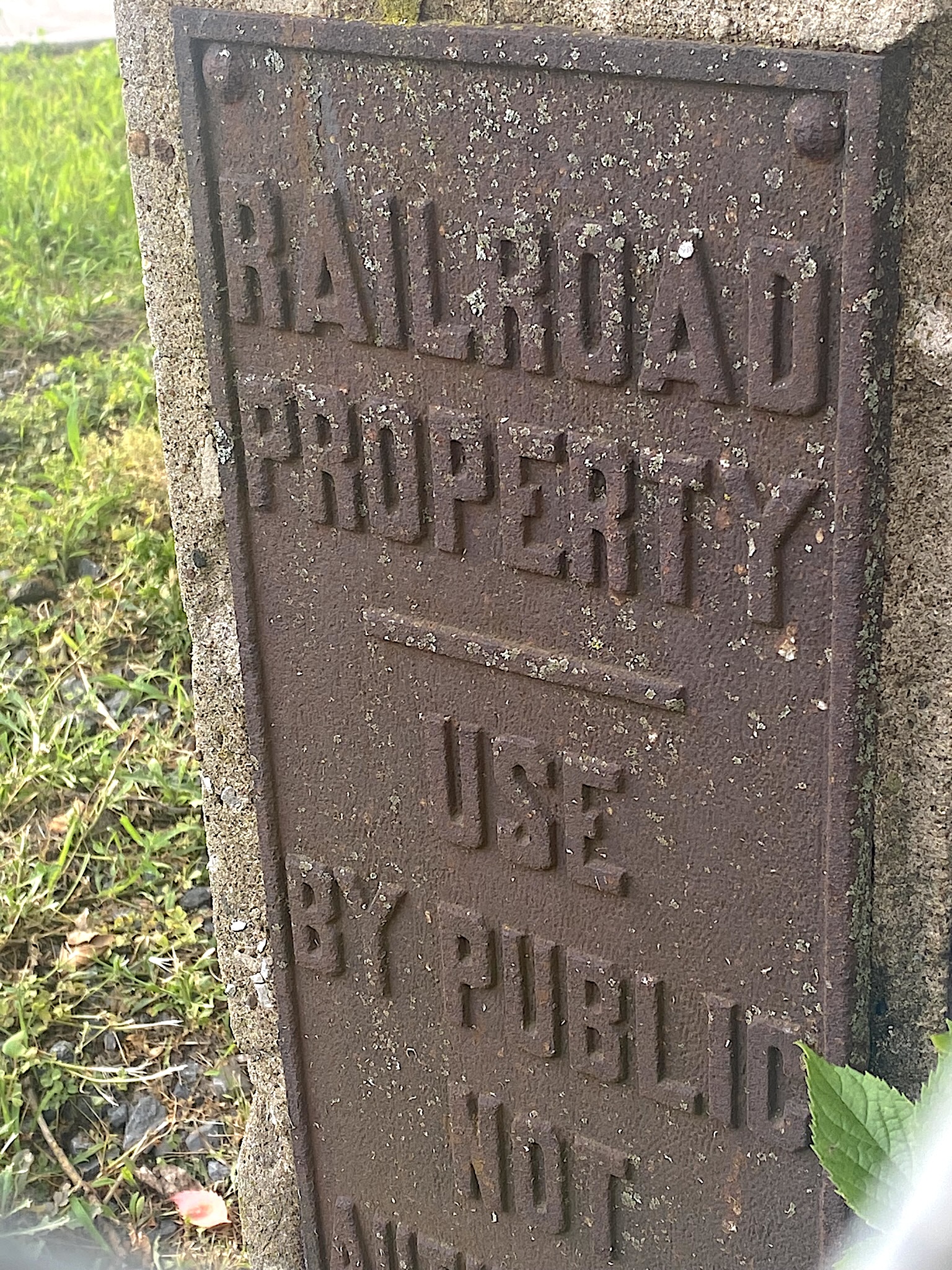
The marker is not easy to see. Gray, rough, and chipped, this rectangular block sits in the ground behind a chain-link fence just inside Sea Gate—the gated community at the end of Coney Island at West 37th Street.

Affixed to each side of the marker is what looks like a copper plaque that reads “Railroad Property: Use by Public Not Authorized.”
It’s a strange find at Sea Gate, a waterside community of 850 homes, per the New York Times. Sea Gate began in 1899 as a private summer retreat for members of the Vanderbilt family as well as the Dodges, Morgans, and other wealthy Gilded Age clans.
Today Sea Gate is still private—its quiet beaches, single-family homes, and historic lighthouse protected by security guards at two entrances.

Since there’s no railroad anywhere near Sea Gate, the concrete marker must have something to do with what occupied this site before the 1890s. In the mid- to late-19th century, this was a rowdy outpost with a pier, hotel, and casino known as Norton’s Point.
Norton’s Point was named for Michael Norton, a Tammany Hall politician who created a rough and tumble area where gangsters hung out and Boss Tweed tried to hide after he escaped from prison in 1875, according to Michael Immerso’s Coney Island: The People’s Playground.
Prior to Brighton Beach and Manhattan Beach’s rise as popular seaside amusement resorts in the late 19th century, Norton’s Point was pretty much the only attraction on the entire Coney Island peninsula.

All that changed after the Civil War with the building of the railroads. That spurred the development of hotels, restaurants, bandshells, and beach pavilions. Hordes of middle-class and working-class New Yorkers soon followed, determined to take advantage of these new seaside amusements.
“In the 1880s the Prospect Park and Coney Island Railroad ran steam trains along this route to the ferry pier at Norton’s Point (Sea Gate),” states the Coney Island History Project. “The trains were later replaced by a trolley line that ran there until November 1948. The route was de-mapped during urban renewal and has disappeared without a trace except for several old railroad property markers.” (Trolley, above, 1940)
The rail tracks are long gone, but at least one concrete property marker remains, ignored and forgotten. Was it put up by the trolley line in the 20th century or one of the original rail lines in the late 1800s? That’s yet to be clarified.
[Third photo: New-York Historical Society]


