Adam Yamey's Blog: YAMEY, page 151
August 26, 2021
Shopping surprise in Suffolk
WE TRAVELLED TO HADLEIGH in Suffolk to see its church, its mediaeval guildhall, and its Deanery Tower. After viewing these buildings on a drizzly afternoon, we walked along the High Street, looking at some of the lovely old buildings along it. Several of them have coloured pargetting (decorative plasterwork). Then, we spotted MW Partridge &Co on the corner of High Street and George Street. From the outside, there is nothing remarkable about this hardware store.
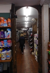
Stepping inside Partridges is like entering an enormous. well organised Aladdin’s cave. Apart from food and plants, there is almost nothing that cannot be found in the shop. One room leads to another, and then another, and yet another, each filled with everything that you might ever need to maintain your home and garden. Remarkable as this is, what is truly fascinating is that apart from one room built as an annexe in the 20th century, the rest of the shop is supported by old-fashioned timber beams and pillars.
According to the company’s history (www.partridgeshadleigh.co.uk/index.php?main_page=about_us), there has been an ironmongery business on the spot since 1823, if not before. In 1823, the ironmonger and iron founder Thomas Pritty acquired the business from a Charles Pretty (or ‘Pritty’). After passing through a couple of other owners, Maitland Walter Partridge and Daniel Partridge of Kersey bought the concern in 1929. This partnership did not last long, and in 1934 Maitland and his sister Edith registered the name M W Partridge & Co. Partridges have been in business ever since.
August 25, 2021
Two colourful churches
THE SUNDAY MORNING SERVICE at the parish church, St Mary the Virgin, in Haverhill in Suffolk had just ended when we entered the building. My wife chatted with a priest, who said he knew little about this church’s history. She asked him if there were any other churches in the district worth a visit. He mentioned two across the county border in Cambridgeshire, at the villages of Bartlow and at Hildersham. The two churches have something of interest in common: unusual colourful paintings.
Bartlow’s St Mary’s church has a distinctive round bell tower. But this is not the only thing that is remarkable about it. It was built in the 11th or 12th century and modified gradually during the following centuries. A real treat greets the visitor on entering the building: some colourful 15th century wall paintings, two on the south wall and one on the north. They depict St George’s dragon (north wall), and opposite this on the south wall: St Michael weighing the souls on The Day of Judgement, and east of it another shows a portrait of St Christopher carrying the Christ Child. The paintings existed long before the Civil War. On the 20th of March 1644, they were covered up with paint by Oliver Cromwell’s men under the command of William Dowsing (1596-1668), a fanatic iconoclast, also known as ‘Smasher Dowsing’. The frescos began to become uncovered in the 19th century, but it was only in 2014 that serious conservation work was undertaken on them.
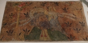 St Christopher painting at Bartlow
The artists who created the wall paintings at Bartlow have been long forgotten, but this is not the case for the creators of the colourful chancel at Holy Trinity Church in nearby Hildersham. In 1806, the Reverend Charles Goodwin was appointed Rector of Hildersham. Ten years later, his son Robert was born. He studied at Clare College in Cambridge and whilst a student he joined The Cambridge Camden Society, whose aims were to promote the study of Gothic architecture and ‘ecclesiastical antiques’. This society grew to be a great influence on the design of Victorian churches.
In 1847, following the death of his father, Robert became Rector of Hildersham’s church. Soon, he began to consider how to ‘restore’ his church in accordance with gothic revival ideals. Amongst these ‘improvements’ was the painting of frescos on the walls of the chancel. These were executed using a novel technique known as ‘spirit fresco’, which made use of a complex mixture of beeswax, oil of spike lavender, spirits of turpentine, elemi resin, and copal varnish. This technique, invented by Thomas Gambier Parry (1816-1888), produced durable images that were easier to produce than the traditional fresco technique used, for example, in renaissance Italy. The chancel at Hildersham was painted using the new technique by Alfred Bell, John Clayton, and Stacy Marks. They and many assistants produced a magnificent display of saints and religious scenes, all from The New Testament. They were painted in 1890 and are in wonderful condition. The two churches are just under 4 miles apart and both are well worth visiting. And, when you do go to these buildings, you will find light switches near their entrance doors. We might never have seen them had it not been for my wife engaging in friendly conversation with the priest at Haverhill.
August 24, 2021
Eating securely at Baltic Amber
HAVERHILL IS IN SUFFOLK, close to where this county’s border meets those of Cambridgeshire and Essex. It is not a place that is near the top of Suffolk’s list of attractions. It does not rival, for example, Lavenham, Bury St Edmunds, Long Melford, and Southwold, to name but a few. However, we chose to spend a couple of nights there. When exploring the town’s dining opportunities, one place caught my attention. It is a restaurant/bar named Baltic Amber.
On the establishment’s website (www.balticamberrestaurant.com/), there is a pair of sample menus. One is in English and the other in Lithuanian. The restaurant was established by a Lithuanian family in March 2020. Despite this, there are only a few Lithuanian dishes on the menu. When we visited, of the five Lithuanian dishes, one must be ordered a day in advance, and, sadly, another was unavailable.
On arrival at this modern place next door to a large Travelodge hotel, we were met at the entrance by two burly but extremely friendly uniformed security guards. One of them checked our names on a list which was attached to a clip board. We asked them if they were expecting trouble. They answered, half jokingly, that they were there to “… keep out the riff-raff to allow diners to enjoy their meals peacefully.” Then, we were led inside and met by a waitress, to whom the security guard said: “table 24”. We were greeted by the lady, who turned out to be Lithuanian and she showed us to our table. I practised the three words of Lithuanian, which I know, on her and later on the owner. Both seemed pleased with my efforts. The interior is modern and almost Scandinavian in design. The chairs at the tables were comfortable. Outside the restaurant, there are tables and chairs as well as a couple of fire-pits around which diners can be seated and kept warm.
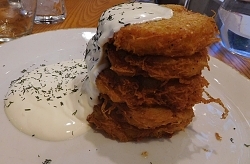 Lithuanian potato pancakes with soured cream
We sampled Mead Vilnius, and aromatic spirit, rather like the Czech Becherovka. We also tried a Lithuanian beer. We ordered one of the Lithuanian dishes to share as a starter. Made of grated potatoes, which were fried and served with thick soured cream, they had a great resemblance to the Jewish dish, ‘latkes’. We followed that with Beef Stroganoff and Duck in an orange sauce. Both were above average both in quality and quantity.
The restaurant was full. The other diners, probably locals, were all having a good time, as did we. The place has good service and a pleasantly lively atmosphere. I am glad that I ‘discovered’ this place and would happily go again.
August 23, 2021
Slavery on the Brink
WISBECH IS A TOWN in northern Cambridgeshire, close to its border with Norfolk. It calls itself ‘The Capital of the Fens’. The River Nene runs through the town. One bank of the river, lined with many fine Georgian buildings is called the North Brink. The opposite bank is known as South Brink. At the eastern end of the Brinks, they are joined by the Town Bridge which crosses the Nene. Near the South Brink end of the bridge, there is a Victorian Gothic memorial.
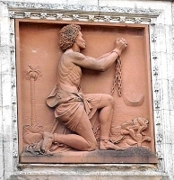
The base of the memorial is square and contains three portraits in bas-relief. One is of William Wilberforce (1759-1833), who is best-known for his work in the abolition of the slave trade, another shows a kneeling African man in chains, and the third depicts Granville Sharp (1735-1813), who was an abolitionist and the founder of the first settlement of freed African slaves in Sierra Leone. A statue standing above the base under a gothic revival canopy is a portrait of Thomas Clarkson (1760-1846), who was born in Wisbech.
Clarkson, who deserves to be as well known as Wilberforce, studied at St John’s College Cambridge, where he wrote an essay in Latin, which asked the question whether it was lawful to make slaves of others against their will. This set him on the road to campaigning against slavery. He was active in this endeavour and helped Wilberforce to get the Slave Trade Act of 1807 passed by Parliament. This legislation did not abolish the slave trade outside the British Empire, but it did encourage British action to discourage other nations from practising it. It was Clarkson who encouraged Wilberforce, a Member of Parliament, to introduce the first Bill against the trade. Clarkson collected much evidence about the horrific nature of the slave trade and used it as evidence in his many publications and public speaking events. Clarkson live for 13 years after The Slavery Abolition Act of 1833. He focussed his later anti-slavery campaigns on, amongst other things, trying to put an end to slavery in the deep south of the USA.
The memorial to Clarkson in Wisbech was put up 1880-81. It was created to a design adapted from one originally proposed by Sir George Gilbert Scott (1811-1878). Though not nearly as grand nor as ornate, the memorial has a slight similarity to a slimmed down version of The Albert Memorial in London. I was pleased to see this statue of Clarkson because last year when visiting Wadesmill in Hertfordshire, we saw a monument to him that records the spot where, while walking from Cambridge to London, he had his revelation that his life should be dedicated to combatting slavery.
August 22, 2021
Mediaeval in a modern metropolis
A SHORT REMNANT OF the old Roman city wall, which used to surround London, runs just south of the church of St Giles Cripplegate, which itself is on the southern edge of the Barbican complex. The garden of Salter’s Hall lies where once a moat ran along the outer side of the wall. And on the other side of the wall, between it and the wide road called London Wall (the A1211), there are the remains of a mediaeval structure, which look as if they might have been the lower part of a gothic tower. These ruins can be examined close-up or a few feet away, seated at a table under the awnings of Barbie Green, an Australian-style, contemporary eatery, which serves good coffee. The restaurant is relatively new, but the ruins have been there far, far longer. Oddly, although we have passed this area often, it was only yesterday, 16th of August 2021, that we first noticed them.
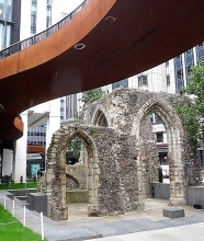
A notice next to the ruins explains that they are all that remains of the tower of St Elsyng Spital, which was also known as ‘The Hospital of St Mary within Cripplegate’ (www.british-history.ac.uk/vch/london/...). This hospital was founded in 1330 by the merchant, a mercer, William Elsyng as a college for priests and to provide shelter and other assistance to London’s homeless blind people (https://ethos.bl.uk/OrderDetails.do?uin=uk.bl.ethos.538317). A victim of the Black Death, he died in 1349. Following his instructions, after his death it became an Augustinian priory, which survived until it was dissolved in 1536 during the reign of King Henry VIII. After its dissolution, the parishioners of the nearby St Alphage Church, which had become derelict, purchased the church of Elsyng’s establishment. According to the architectural historian Nikolaus Pevsner, the 14th century tower, whose remains we saw, was incorporated into the structure of St Alphage. St Alphage was demolished at the end of the 16th century and its parishioners used what was left of Elsyng’s priory church, which was eventually replaced by a newly built church on a different site in 1777 (https://en.wikipedia.org/wiki/St_Alphege_London_Wall).
The well-maintained ruins consist of several tall gothic arches connected to each other by walls made of roughly hewn stones and mortar. Most of the arches are arranged around what was once the base of a tower. This mediaeval site is surrounded by modern buildings, lies beneath a sinuous elevated oxidised metal walkway. It is sandwiched between the fragment of London’s Roman Wall and the busy London Wall dual carriageway. Part of the joy of stumbling across this relic of pre-Reformation architecture is that unlike so many others we have seen on our travels, it is in the heart of a modern metropolis rather than a rustic environment.
Small though it is in comparison with its modern surroundings, finding this reminder of London’s distant past, founded long ago by a philanthropic merchant, was a delightful surprise. Even today, so many centuries later, philanthropy thrives in the heart of the old City of London in the form of the descendants of the guilds, of which The Salters, whose hall I mentioned above, is just one example of many.
PS: The nearest Underground station is Moorgate
August 21, 2021
A lost landmark and a treasured map
EVER SINCE I CAN REMEMBER, I have been fascinated by maps and collected them. I cannot say exactly why I enjoy them, but one reason is that I get satisfaction from aesthetic aspects of cartography. Another reason is that when I look at them, I try to imagine the reality that they represent, a form of virtual travelling. Whatever the underlying cause(s) of my fascination with maps might be, it is irrelevant to what follows because what I want to tell you is about a shop that I used to love to visit. It was Stanford in London’s Long Acre, a street not far from the old Covent Garden Market and Leicester Square.
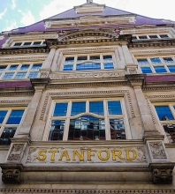
Founded by Edward Stanford (1827-1904) in the early 1850s, his business was one of the best specialist suppliers of maps in the UK, if not the very best. His company’s store on Long Acre opened in 1901, having moved there from Charing Cross. When I used to visit the shop to browse the lovely maps on display in the 1960s, there were two floors open to the public. The ground floor was the main showroom with maps of popular destinations that appealed to the majority of customers. The basement was less attractively arranged but far more interesting to serious travellers and map collectors such as me. There were no maps out on display down there. One had to ask a salesman to show you maps of areas that interested you. I believe it was there that I bought a nautical chart of the extremely remote French island of Kerguelen in the southern part of the Indian Ocean, a place that I had no intention of ever visiting.
In about 1966, my interest in Albania was born. I have tried to explain why this happened in my book “Albania on My Mind”, which I published in 2013, 101 years after Albania gained its independence. In those days, not much was known in the UK about this small country in the western Balkans. Maps of Albania were not available in most shops, probably because few people visited the place, or were even remotely interested in it. So, I took the Underground from my local station, Golders Green, to Leicester Square. Stanford was a few yards from that station. At Stanford, I enquired about detailed maps of Albania, and was sent to the specialist map department in the basement.
The only detailed map of Albania available at Stanford was a 1:200,000 scale map with the information that it was made:
“Auf Grund der Oesterreichischer-Ungarische Kriegsaufnahmen und der im Auftrage der Albanische Regierung Von Dr Herbert Louis gemachten aufnahmen sowie mit Benützung italienischer und franzoesischer Karten” (i.e., ‘On the basis of the Austrian-Hungarian war recordings and the recordings made by Dr Herbert Louis on behalf of the Albanian government, as well as with the use of Italian and French maps’)
The map, which comes as two sheets, was up to date in 1925. A small map alongside the main map shows which parts of the large map were surveyed by whom and when. Between 1916 and 1918, the surveyors were the armies of Austria-Hungary, France, and Italy. Some information collected by Baron Nopcsa between 1905 and 1909 is included in the map, as well as data collected by Dr H Louis between 1923 and 1924.
Baron Nopcsa was the Hungarian aristocrat and politician Franz Nopcsa von Felső-Szilvás (1877-1933; see: http://www.smithsonianmag.com/history/history-forgot-rogue-aristocrat-discovered-dinosaurs-died-penniless-180959504/), a founder of paleobiology and a specialist on Albanian studies. This one-time candidate for the throne of Albania created the first geological map of northern Albania. The German Dr Herbert Louis (1900-1985), whose name is prominent on the map, was no stranger to Albania. In 1923, he accompanied the Austrian geologist Ernst Nowack (1891-1946) during his research in the country, and in 1925, he was awarded a doctorate for his studies concerning Albania.
The map looked beautiful, I fell in love with it, and I knew I had to obtain a copy of it, but it was priced at 23/- (23 shillings: £1.15) for the set. That might not sound excessive today in 2021, barely the price of a small bar of chocolate or a cup of tea (in a scruffy café). But in about 1966, it was a huge sum of money for me, many times more than my weekly pocket money. I left Stanford, determined to save up for it and hoping that in the meantime the shop would not run out of copies of it. Eventually, I was able to purchase a set of these maps.
Delicately drawn, covered with contour lines, shaded representations of rocks and mountains, a variety of colours, the map shows how few roads there were in Albania in the 1920s. The tiny black dots, which represented buildings or small groups of them are often shown to be connected by tracks or footpaths, but many of them are a long way from any line of communication marked by the map makers. Most of the names on the map are in Albanian, but a few are also in Italian (e.g., Durazzo [Durres], Valona [Vlora], San Giovanni di Medua [Shengjin], and Santi Quaranta [Saranda]). Some words on the map are also in German.
I treasure this set of maps I bought at Stanford so many years ago and my memory of first being shown them in the basement of the shop. Yesterday, on the 15th of August 2021, first day of the 75th year of India’s independence, we walked along Long Acre, and discovered that although its name on the building is still there, the map shop is not. I had not realised that in 2019 this repository of records of landmarks and one of my favourite childhood haunts had moved from Long Acre to nearby Mercer Walk near The Seven Dials.
August 20, 2021
Poetry on a wall
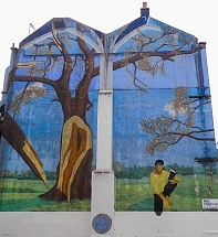
Yesterday, Sunday the 15th of August 2021, we noticed an attractive wall painting not far from the large Liberty shop on Great Marlborough Street. It is the Soho Mural in Noel Street, the eastern continuation of Great Marlborough Street. With the title “Ode to the West Wind”, it was created in 1989 by Louise Vines and The London wall Mural Group, whose telephone number (on the circular blue patch) was then 01 737 4948 (now, the number would begin with 0207 instead of 01).
More information about this mural and its quote from the poet Percy Bysshe Shelley can be found at http://londonmuralpreservationsociety.com/…/ode-west-wind/
August 19, 2021
After Armageddon? An art installation
ORFORD NESS IS a desolate strip of land on the Suffolk coast. Separated from the rest of the county by the lower reaches of the River Alde, it was used for testing military technology during much of the 20th century. While it was in the hands of the military, it was strictly out of bounds for everyone except those who were authorised to be there. It was a highly secret military area, more about which I plan to write soon.
In the early 1990s, the Ness was handed over to the National Trust, who developed it and the decaying remains of the military establishment as a visitor attraction and nature reserve.
This Summer (2021), an organisation called Artangel, who “…collaborate with artists who defy boundaries to give form to extraordinary ideas,” (www.artangel.org.uk/about_us/), have placed several intriguing art installations on Orford Ness. One of these, which I particularly liked, is called “The Residents”. It was created by Tatiana Trouvé, who was born in Calabria and grew up in Dakar, Senegal.
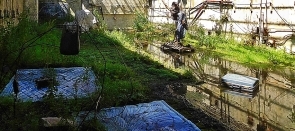
Her installation is housed in a concrete structure half buried in shingle and called Lab 1. It was in this bunker, built in the 1960s, that detonators for Britain’s atomic bombs were tested for their resistance to vibration and other forces that might set off detonators at inappropriate times, for example, when being carried in aircraft.
Like most of the rest of the deserted military establishment on Orford Ness, Trouvé’s collection of objects in the disused, dilapidated bunker, creates an intense feeling of a post-Armageddon world. The artist populates the space with a variety of objects, such as suitcases, cloth bags, books, quilted mattresses and rugs, and a transistor radio. All of these objects look as if they have been discarded by people fleeing an horrific disaster. All of them are painted to look life-like, but none of them are real; they are all cast in either aluminium or bronze. This is also the case for the life-like seashells attached to the gate through which the observer looks at this created scene of despair.
Surrounded by acres of shingle covered with distorted, rusting fragments of metal and discarded lumps of concrete, the installation housed within Lab 1 gave me the feeling that I was being given a glimpse of what I hope never to experience: the world following a nuclear catastrophe.
August 18, 2021
Drums in Afghanistan
RUDYARD KIPLING PUBLISHED his story “Drums of the Fore and Aft” in 1889 (www.kiplingsociety.co.uk/rg_foreandaft1.htm). Based on an incident that occurred in the Second Afghan War (1878-1890), most likely during a battle at Ahmed Khel in 1880, his tale includes the story of two drummer boys, who, fortified with rum and courage, march up and down the battlefield playing the tune of the song, “The British Grenadiers”, which, incidentally, we used to sing at school in the early 1960s. Although the British defeat their enemy, the boys are killed. Well, I doubt that I would have ever known about this story had we not recently visited Woodbridge on the backwaters of the coast of Suffolk.
Much of Woodbridge is located on the slope of a hill. Its picturesque Market Hill is high up on this incline. It contains many buildings that have been in existence for several centuries. In the centre of the square, stands the Shire Hall, a rectangular brick building with stone trimmings and gables at both ends of its roof. The gables give the building a somewhat Dutch appearance. The edifice is believed to have been built in about 1575 by a local worthy, a politician and member of the court of Queen Elizabeth I, Thomas Seckford (1515-1587). Since then, it has been modified a little, but not to its detriment.
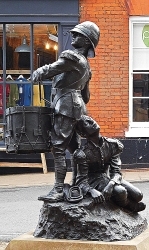
Just outside the eastern end of the Shire Hall, we found a sculpture depicting two young soldiers. One is standing, beating a drum, and the other is sitting on the floor looking upward, a discarded bugle at his feet. A plaque next to the sculpture reads as follows:
“’Drums to the Fore and Aft’. Gifted to the Town by the Duchess of Albermarle following her husband’s wishes in January 1980. Sculpted by Arnold, 8th Earl of Albermarle. Re-sited to this position in March 2018.”
When I saw this, I wondered about the aristocratic creator of this lifelike sculptor.
Arnold was Arnold Allan Cecil Keppel, 8th Earl of Albemarle (1858-1942), soldier, courtier, and Conservative politician (https://en.wikipedia.org/wiki/Arnold_Keppel,_8th_Earl_of_Albemarle). Educated at Eton College, he fought in the 2nd Anglo-Boer War (1899-1902) after having been an MP for Birkenhead between 1892 and 1894. On becoming the 8th Earl, he took his late father’s place in the House of Lords. His wife was born Lady Gertrude Lucia (1861-1943). As she died in 1943 and the town only received the sculpture in 1980, it seems to have taken a long time for her late husband’s wishes to be fulfilled. At least that is what I thought until I looked into the story behind this work of art.
As for the sculpture in Woodbridge, Wikipedia includes the following about Arnold Keppel’s relationship with it:
“He is credited with sculpting the statue of the two drummer boys from Rudyard Kipling’s story ‘The Drums of the Fore and Aft’ that now stands in Woodbridge, Suffolk.”
The Recording Archive for Public Sculpture in Norfolk & Suffolk, a database of sculptural works within the two counties, has the following information about the sculpture (http://racns.co.uk/sculptures.asp?action=getsurvey&id=373):
“8th Earl of Albemarle Sculptor(s). Private commission by 8th Earl of Albemarle. 1901, the cast may be later since the foundry only adopted the name A.B.Burton in 1902, after the death of the other partner, A.J. Hollinshead.”
An illustration in the Archive’s website shows a plaque, which I did not see. This provides the information that the sculpture was given to the town in January 1980 in memory of Walter Keppel, the 9th Earl of Albermarle (1882-1979). Another photograph shows that the sculpture is signed “Albermarle 01”. ‘Albermarle’ was Walter’s father, and ‘01’ refers to 1901. Having learned all of this, I now realise that the sentence I read on the plaque, “Gifted to the Town by the Duchess of Albermarle following her husband’s wishes in January 1980.”, refers not to the 8th Earl’s widow, but to the widow of his son, Walter.
The sculpture is well executed, showing that its maker was a competent artist. A search of the Internet revealed that in addition to the sculpture in Woodbridge, he also drew portraits (e.g. https://auctions.roseberys.co.uk/m/lot-details/index/catalog/299/lot/116339?uact=5&aid=299&lid=116340¤t_page=0). Otherwise, I can find hardly anything else about his artistic output. That said, if the sculpture in Woodbridge is the only example of his modelling, it is something that the late 8th Earl must been pleased with.
August 17, 2021
Locked in a church overnight
THE BATTLE OF NASEBY was fought on the 14th of June 1645 between the Royalists, led by King Charles I and his nephew Prince Rupert of the Rhine, and the Parliamentarians, led by Sir Thomas Fairfax and Oliver Cromwell. It was a victory for the Parliamentarians and the last major battle in the (First) English Civil War (1642-1646), putting an end to any hopes that the king had of winning the conflict. The battlefield at Naseby is about 5 miles southwest of the small Leicestershire town of Market Harborough, which we visited for the first time in July 2021. We dove there, almost accidentally, after having had a frustrating experience navigating the ring road around the town of Rugby without finding a route to its old centre. Shamefacedly, I must admit that we were completely ignorant of this town’s connections with the Civil War and the Battle of Naseby.
It was at Market Harborough that King Charles had his headquarters before the fight at Naseby. I am not sure which buildings in the town were used by the king, but one of them, still in existence, might possibly have been visited by the royal person. This is the former coaching inn, The Three Swans. Its website informs us with appropriate cautiousness:
“Like most old inns, The Three Swans has become the subject of a number of legends, often passed on with varying degrees of accuracy. One is that Charles I visited the inn on the night before the Battle of Naseby in June 1645. According to surviving records made at the time, the king actually retired for the night two miles down the road at the private house of Lubenham Hall. He was raised from his bed at 11pm by reports of the unexpected arrival of the Parliamentarian army just eight miles away at Naseby. He rushed to Market Harborough to meet his senior General, his nephew, Prince Rupert of the Rhine, who had established his military headquarters in the town.
At midnight they met with several other commanders for a council of war. The venue for the meeting is unknown. It could have been The Swan, or it could just as easily have been anywhere else in the town…” (from a pdf accessed via www.threeswans.co.uk/about/history/).
An information plaque in the town suggests that on the eve of the battle, the king and Prince Rupert conferred in an Inn on Church Street, the site of the present Kings Head Pub. The present establishment was built in the 19th century.
There might be some uncertainty about the king’s whereabouts in Market Harborough before the Battle of Naseby, but there is no doubt where some of his soldiers spent some time as prisoners after the Royalists were defeated. After the battle, the Parliamentarian Provost Marshall had to secure the 4000 to 5000 Royalist soldiers who had been captured during fight at Naseby. The only building in Market Harborough large enough to house this large number of captives and to secure them was the centrally located church of St Dionysius, which is close to both the Three Swans and The Kings Head. They were held in the church for one night before they were marched to London via nearby Northampton.
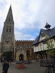 St Dionysius church and The Old Grammar School in Market Harborough
The construction of the Church of St Dionysius with its tall tower with steeple was started in the 13th century, but much of its structure dates to the 14th and 15th centuries. High up on a wall at the west end of the church is a depiction of the royal coat-of-arms dated 1660. This was the date when the monarchy, led by King Charles II, was restored in England. Five years earlier, the church was crowded with tired soldiers, who had fought in vain for Charles’s father, who was executed on the 30th of January 1649.
Some, if not all, of the Royalist soldiers, who were about to be incarcerated in St Dionysius, might have noticed a curious structure next to its southern side. Built in 1614, this building, which stands on sturdy wooden posts at least 6 feet high, must have seemed quite new in 1645. It was the grammar school founded by in 1607 by Robert Smyth, a resident of the town who became Comptroller of the City of London’s Chamber and member of the Merchant Taylors’ Company. The structure, which you see today, was funded by Smyth’s money. The school, which is accessed by a staircase, stands raised high above the ground. The space beneath it was created to keep the town’s market dry in wet weather. Many years later, a descendant of this school was established elsewhere in the town. Now known as the Robert Smyth Academy, one of its past students was the Nobel Prize winning physicist, Sir William Henry Bragg.
Today, the centre of Market Harborough is pleasantly vibrant with a good range of shops and eateries. Contemporary life and memories of the town’s history rub shoulders harmoniously in this place that deserves the attention of more tourists.
On our return from Market Harborough and the fascinating Foxton lock staircase nearby, we did manage to find our way into the heart of the town of Rugby, which did not impress us nearly as much as Market Harborough.


