
Jeffrey E.F. Friedl's Blog, page 17
August 5, 2016
Toolin’ Around on a Mini Baja
Nikon D4 + Nikkor 24-70mm f/2.8 @ 70mm — 1/320 sec, f/2.8, ISO 140 —
map & image data — nearby photos
Toolin' Around on a Mini Baja
My brother Alan and his daughter Felicity
Nikon D4 + Nikkor 24-70mm f/2.8 @ 28mm — 1/320 sec, f/2.8, ISO 100 —
map & image data — nearby photos
Yeah Baby


July 26, 2016
Kyoto to Ohio, Summer 2016 Edition
Nikon D4 + Nikkor 24-70mm f/2.8 @ 70mm — 1/320 sec, f/8, ISO 125 —
map & image data — nearby photos
Mt. Fuji
under the rising sun
å¯å£«å±±
from 77km away and 5½km above (48 miles away and 3½ miles above)
I traveled again yesterday from Japan to Ohio (Kyoto â Osaka â Tokyo â Chicago â Cleveland â Rootstown)
to spend some time with my folks, especially since my mom had a stroke earlier in the year. I wanted Anthony to
see the property I grew on one more time, so he came along for this trip.
I don't like having to pop up to Tokyo for the transpacific flight, but that hour-long flight from Osaka to Tokyo always holds
the promise of a nice Mt. Fuji view, so that's something to look forward to. Mt. Fuji isn't quite so pretty during the summer,
as without the cone it's just a big dark cinder cone (This bland shot with snow is
not looking so bad now.), but Mt. Fuji is Mt. Fuji.
Nikon D4 + Nikkor 24-70mm f/2.8 @ 32mm — 1/640 sec, f/8, ISO 100 —
map & image data — nearby photos
Smart Marketing
Airline name on the inside of the winglet
puts the name in all the out-the-window photos
Desktop-Background Versions
1280×800 · 1680×1050 · 1920×1200 · 2560×1600 · 2880×1800
Nikon D4 + Nikkor 24-70mm f/2.8 @ 24mm — 1/640 sec, f/8, ISO 100 —
map & image data — nearby photos
It's a Big World
this picture was taken 48km (30 miles) from where the first was
Nikon D4 + Nikkor 24-70mm f/2.8 @ 70mm — 1/160 sec, f/2.8, ISO 720 —
map & image data — nearby photos
“Friendly Skies” Personified
impromptu portrait with United Airlines flight-attendant Jason
while waiting to exit my flight at Cleveland Hopkins International Airport
Our flight from Chicago to Cleveland was on United Airlines, and one of the flight attendants had
the most amazing smile permanently affixed to his face. Whether standing back to observe while people
boarded, or while helping people board, or while doing the safety presentation, or while passing out
drinks and snacks, this smile just radiated at 11 the whole time.
I sat at the back of the plane, so I could watch for a long while as he passed out a packet of snacks and a napkin to each
passenger, working his way forward. Each time he passed something out, the smile made you feel that it was the highlight of his
day. It was really quite amazing to watch.
The whole time I watched, the smile wavered only twice, each time suddenly blooming into an even more dazzling display, though
one touched with a hint of embarrassment; I could tell that he must have just been complimented on his smile.
It really brought a lovely glow to the short flight, one that I appreciated all the more in my jet-lagged zombie state, though
it made me wonder why I can't manage that kind of smile for even the 1/60th of a second for a photo. Sigh.
Once we pulled up to the gate, I knew it would take a while before people would clear out enough for me to actually exit, so
what the heck, I went to the back galley to ask him for a portrait. I mentioned that he must get complimented on his smile all the
time, and he got this “well, actually...” look on his face and said that he didn't, but had been complimented twice on this
flight. I smiled to myself and thought “called it!”.
He kindly agreed to a portrait, and I spent a few seconds trying to take it as he stood, but the back galley of a 737 isn't the
best place for a portrait and the lighting was really bad. I didn't want to take any more of his time than I already was, so I
quickly adjusted his position to one side of the galley where the light was a bit smoother, and a few seconds later I had the
photo above.
I took the time to get his employee number so that I could pass along this sentiment to United directly, and his email so that
I could send a copy of the photo, and by then the ground crew were coming in the back entrance, so I left him to his work.
Nikon D4 + Nikkor 24-70mm f/2.8 @ 24mm — 1/50 sec, f/2.8, ISO 250 —
map & image data — nearby photos
Still Waiting to Exit
I've got time for another dozen portraits...
Dad picked us up at the airport, and we stopped by to see Mom, who was looking great. Jetlag shooed us home quickly,
though, and we both slept through the night pretty well.
In the morning I took Anthony up to where I went to high school to borrow the soccer goals...
Nikon D4 + Nikkor 24-70mm f/2.8 @ 62mm — 1/2500 sec, f/2.8, ISO 100 —
map & image data — nearby photos
Corner-Kick Practice
aiming for the cone in the upper corner
Rootstown High School, Rootstown Ohio
Nikon D4 + Nikkor 24-70mm f/2.8 @ 40mm — 1/800 sec, f/5.6, ISO 100 —
map & image data — nearby photos
Close Enough
Anthony asked whether they had these goals here when I went to school, and I had to answer truthfully that I had no idea... I never paid attention to soccer or any sport when I was in school. He couldn't comprehend the idea, which silently pleased me to no
end.
July 14, 2016
Monday’s Norikura Big Loop Ride
Panasonic LX100 — 1/800 sec, f/5.6, ISO 200 —
map & image data — nearby photos
Theme for the Day
amazing roads, amazing vistas, wonderful weather, no cars
ãã®è¨äºã¯ãã®éã®æææ¥ã®ãµã¤ã¯ãªã³ã°ã®ç©èªã§ããåéã¨ä¸ç·ã«ä¹éãç»ã£ããè·é¢165ããã®ãã¼ã³ã°ã©ã¤ããããããã
é²ãã å³ ã¯ä¹éãç¾å¥³å³ ã寺åå³ ãééº¦å³ ãç½æ¨ºå³ ãç²å¾é«åº¦ã¯3,907mãç²ããããã©ãããã£ã¡ã楽ããã£ãããªã¼ãã¼éåå·ããã¨æ ç°ãããåå ããã¦ãããæãé£ã御座ãã¾ãï¼
In yesterday's post I outlined a three-day trip where I cycled up Japan's highest paved road three times. The main event was the middle day, with a group of folks from Kyoto that comes every
year. The day's ride started with that highest-road climb up Mt. Norikura, then continued on to four other major climbs in a big up-and-down loop covering 165km (103mi) with 3,900m (12,800') of elevation gain.
Here's the ride at Strava, and a
surprisingly-interesting 2-minute Relive video version.
It ended up being the fifth longest ride I've ever done, though the most elevation gain in one day.
Some of us started out at about 6:15am, and met up with the others...
Panasonic LX100 — 1/800 sec, f/5.6, ISO 200 —
map & image data — nearby photos
Meeting Up
6:50am
I didn't know most of the people in the group, so I'll introduce some of them as we go along.
Panasonic LX100 — 1/320 sec, f/5.6, ISO 200 —
map & image data — nearby photos
Yoshiyuki Takenami
6:55am - taken while cycling at 19 kph (12 mph)
Panasonic LX100 — 1/125 sec, f/5.6, ISO 200 —
map & image data — nearby photos
Entering the Woods
6:56am - taken while cycling at 16 kph (10 mph)
Panasonic LX100 — 1/160 sec, f/5.6, ISO 200 —
map & image data — nearby photos
Leaders and Friends
6:57am - taken while cycling at 13 kph (8 mph)
The two leaders of the group are Mr. Yasukawa (front left) and Mr. Kurita (rear left).
They invited Manseki (rear right) whom I ride with often, and so via Manseki I, and some others
such as fellow American Yifen (front right), joined in.
Panasonic LX100 — 1/640 sec, f/5.6, ISO 200 —
map & image data — nearby photos
Still With a Bit of Snow
DMC-SZ9 — 1/320 sec, f/3.1, ISO 160 —
map & image data — nearby photos
Me, Taking The Photo Above
I'd taken my D4 and lenses yesterday, but for this ride just the small LX100
photo by Manseki Kanemitsu
Panasonic LX100 — 1/125 sec, f/4.5, ISO 200 —
map & image data — nearby photos
Most-Veteran Member
in his 70s
Panasonic LX100 — 1/1000 sec, f/5.6, ISO 200 —
map & image data — nearby photos
Newest Rider
Yoriko is doing a 1,235m (4,000') climb after only four months of riding
(the red scarf is to avoid the sun)
Panasonic LX100 — 1/250 sec, f/5.6, ISO 200 —
map & image data — nearby photos
Mrs. Yasukawa
the leader's wife
Panasonic LX100 at an effective 24mm — 1/3200 sec, f/9, ISO 200 —
map & image data — nearby photos
Glorious Weather
7:11am
Desktop-Background Versions
1280×800 · 1680×1050 · 1920×1200 · 2560×1600 · 2880×1800
We all started together, but the members would split into three groups after the summit, with one group heading right back down
to the hotel, one group doing the long ride I'll be showing in this post, and finally another group of intermediate riders doing
a shorter loop.
It says something about the level of this group of folks, though, that the “intermediate” shorter loop is essentially the 100km ride I'd
done the previous day that had so wiped me out.
Panasonic LX100 — 1/320 sec, f/5.6, ISO 200 —
map & image data — nearby photos
Panasonic LX100 — 1/125 sec, f/2.2, ISO 200 —
map & image data — nearby photos
Panasonic LX100 — 1/1600 sec, f/6.3, ISO 200 —
map & image data — nearby photos
Now On the Norikura Climb Proper
looking back to the ski area that marks the start
(Mrs. Yoshikawa is on the foreground road, center left)
7:41am - taken while cycling at 9 kph (6 mph)
DMC-SZ9 — 1/400 sec, f/3.1, ISO 100 —
map & image data — nearby photos
Me Again
7:46am - the same photo from yesterday's post, just to have it here too
photo by Manseki Kanemitsu
Panasonic LX100 — 1/500 sec, f/5.6, ISO 200 —
map & image data — nearby photos
Mr. Yoshikawa
8:17am - taken while cycling at 9 kph (6 mph)
Panasonic LX100 at an effective 24mm — 1/500 sec, f/5.6, ISO 200 —
map & image data — nearby photos
Looking Back
to where we started
Desktop-Background Versions
1280×800 · 1680×1050 · 1920×1200 · 2560×1600 · 2880×1800
Panasonic LX100 — 1/800 sec, f/5.6, ISO 200 —
map & image data — nearby photos
7 Minutes Later
The building at left in the photo above is a small lodge that sort of marks the halfway point from the ski area,
though it's actually closer to 60% of the way up. The photo just prior to that was taken from near the lodge.
Panasonic LX100 — 1/1000 sec, f/5.6, ISO 200 —
map & image data — nearby photos
Enjoying the View
8:25am
Panasonic LX100 — 1/400 sec, f/4.5, ISO 200 —
map & image data — nearby photos
Attempt at a Selfie
I'm not as good as Gorm at it
8:34am - taken while cycling at 10 kph (6 mph)
Panasonic LX100 — 1/1250 sec, f/5.6, ISO 200 —
map & image data — nearby photos
Now Above the Forest
8:42am — with Mr. Yoshikawa in view
Panasonic LX100 — 1/640 sec, f/5.6, ISO 200 —
map & image data — nearby photos
Water Stop
water water everywhere, and it's pretty much all okay to drink
Panasonic LX100 — 1/1250 sec, f/5.6, ISO 200 —
map & image data — nearby photos
End in Sight
sort of
8:44am - taken while cycling at 12 kph (8 mph)
The observatory seen in the photo above is actually a 150m (500') climb above the road pass,
and the peak of the mountain (not visible in this photo) is that much farther up yet again. Access to
either is only by foot, so I didn't visit.
When you get this view you might feel you're almost there, but it's actually still another 2km (1.2mi) of twisty, steep road to
go.
Just to give you a sense of scale that the photo above totally lacks, notice the little section of snow in the middle, just
above where it looks like the road ends. Here's a photo of that same “little” section of snow that I took yesterday, from closer in:
Nikon D4 + Nikkor 24-70mm f/2.8 @ 70mm — 1/200 sec, f/11, ISO 100 —
map & image data — nearby photos
Small Spot of Snow
with one person climbing it
(the spot in the back has four people on it)
Panasonic LX100 at an effective 24mm — 1/1000 sec, f/5.6, ISO 200 —
map & image data — nearby photos
Find the Leader
Mr. Yoshikawa is in this shot somewhere
8:46am - taken while cycling at 11 kph (7 mph)
Desktop-Background Versions
1280×800 · 1680×1050 · 1920×1200 · 2560×1600 · 2880×1800
Panasonic LX100 — 1/1000 sec, f/5.6, ISO 200 —
map & image data — nearby photos
Iago Returns
8:47am - taken while cycling at 12 kph (8 mph)
Spanish friend Iago, whom I first rode with on my first Kyoto Heart Loop, had
finished the climb well before me, and returned back to help me finish it.
Panasonic LX100 — 1/1000 sec, f/5.6, ISO 200 —
map & image data — nearby photos
Excess of Power
8:48am - taken while cycling at 11 kph (7 mph)
(Yes, he's not wearing a helmet. Yes, we all think he's an idiot for it. Yes, he's an adult who can make choices for himself.)
Nikon D4 + Nikkor 24-70mm f/2.8 @ 70mm — 1/200 sec, f/11, ISO 640 —
map & image data — nearby photos
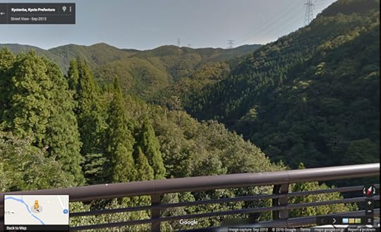
What Passes for a Pass
The highest point in the road is not special except, well, for being the highest point in the road, and I
guess also being on the border between Gifu and Nagano prefectures. There's no elevation marker, but it's about 2,715m
(8,908'). The only photo I have of it is the meager one seen above that I took
the previous day; you can get a better sense of the bleakness with the Google Streetview view.
Just over the pass is an area called Tatamidaira (ç³å¹³), where there's a visitor's center from which hiking paths
lead to various points on the mountain. There's also a pretty little lake.
Panasonic LX100 at an effective 24mm — 1/640 sec, f/5.6, ISO 200 —
map & image data — nearby photos
Volcanic Lake
8:54am - taken while moving at 22 kph (13 mph)
Desktop-Background Versions
1280×800 · 1680×1050 · 1920×1200 · 2560×1600 · 2880×1800
Panasonic LX100 — 1/800 sec, f/5.6, ISO 200 —
map & image data — nearby photos
Entrance to the Visitor's Center
8:54am - taken while cycling at 23 kph (14 mph)
Panasonic LX100 — 1/1250 sec, f/5.6, ISO 200 —
map & image data — nearby photos
Taking a Well-Earned Break
9:25am — the “long ride” group
we still have 140km (87mi) left to ride
Panasonic LX100 — 1/1250 sec, f/5.6, ISO 200 —
map & image data — nearby photos
Getting Ready to Head Down
9:51am - taken while cycling at 30 kph (19 mph)
Panasonic LX100 — 1/1250 sec, f/5.6, ISO 200 —
map & image data — nearby photos
Do Not Overcook These Turns
unless you can sprout wings
9:51am - taken while cycling at 47 kph (29 mph)
Panasonic LX100 — 1/1000 sec, f/5.6, ISO 200 —
map & image data — nearby photos
Lots of This
9:53am - taken while cycling at 26 kph (16 mph)
Panasonic LX100 — 1/800 sec, f/5.6, ISO 200 —
map & image data — nearby photos
And This
these curves are not at all the same as the ones seen above
There were also some very long beautiful straightaways that at first seemed to be born to break speed records, but considering
that they invariably ended with very sharp hairpins that allowed no margin for error, I kept my speed under 80kph (50mph) the
whole way. I like going fast, but I'm not into taking stupid risks.
In this next shot you can see where we're heading next....
Panasonic LX100 — 1/1000 sec, f/5.6, ISO 200 —
map & image data — nearby photos
Toward the background frame left are little blotches of civilization among the rolling forest. That's where we're going,
but to get there we have to ride 40km (25mi) and drop 2,000m (6,550') of elevation.
Panasonic LX100 — 1/1000 sec, f/5.6, ISO 200 —
map & image data — nearby photos
Racing the Bus
my last shot of Manseki flying by before I put the camera away to beat the bus
The roads up and down Mt. Norikura are closed to private motor vehicles, so they're empty except for the occasional bus, taxi,
or official vehicle (and of course cyclists and hikers). A car or bus in front of you on the descent would destroy the fun of it,
and you can see one approaching in the shot above, so I put the camera away and joined the group.
There can be a lot of cyclists, though this day there weren't so many. When I entered the closed-to-traffic part the previous
day, a Sunday, the guard said that I was the 94th cyclist of the day. This day I entered much earlier, and was the 9th. (The next
day I entered at about the same time as the first, and was the 30th).
Panasonic LX100 — 1/1000 sec, f/5.6, ISO 200 —
map & image data — nearby photos
Back On the Open Road
10:16am — the “long ride” group, after the main descent
The “long ride” group consisted of, left to right in the photo above,
Mr. Kurita (Japan),
Iago (Spain),
Yoshiyuki (Japan),
Antti (Finland),
Yifen (USA),
Mr. Yasukawa (Japan),
Manseki (Japan), and me (USA).
We don't see Antti much in this post because he's “Antti Gravity” and rides so fast that he outruns photons. We did see him a bit in last month's “Grueling Rooftop-of-Kyoto Ridge
Road Gravel Grind”, last year's “Obama Hosts My First Bicycle
Visit to the Sea”, and many in between.
Panasonic LX100 — 1/500 sec, f/5.6, ISO 200 —
map & image data — nearby photos
Rugged Beauty
10:38am
Panasonic LX100 — 1/2000 sec, f/8, ISO 200 —
map & image data — nearby photos
Least-Fun Part of the Ride
10:50am - taken while cycling at 44 kph (27 mph)
Sometimes my chain pops off when hitting a rough patch of road at high speed, but often I can restore it quickly, at times without stopping or even slowing down, but it happened along the way
today in such a way that the chain got fouled in the derailleur, so it took a
minute to fix.
Normally in a social group ride we make sure that the last rider is never alone, but I'd waved the others on thinking it'd be
just a few seconds to fix. Even though I averaged 40kph (25mph) for the next 40 minutes (40 minutes), I wasn't able to catch
up until they stopped for a break.
Panasonic LX100 — 1/400 sec, f/5.6, ISO 200 —
map & image data — nearby photos
We Meet Again
11:06am
Panasonic LX100 — 1/800 sec, f/5.6, ISO 200 —
map & image data — nearby photos
Manseki Cools Down
11:28am
Panasonic LX100 — 1/800 sec, f/5.6, ISO 200 —
map & image data — nearby photos
Climbing Again
after almost three hours of descent
11:38am - taken while cycling at 18 kph (11 mph)
Panasonic LX100 — 1/400 sec, f/5.6, ISO 200 —
map & image data — nearby photos
Heading Into The Next Big Climb
11:55am - taken while cycling at 19 kph (12 mph)
After a few minor ups and downs, it was time for ascent #2 of 5, though the smallest of the bunch
(just 250m/820', which is about what some of us climbed from the hotel to the starting place).
Panasonic LX100 — 1/400 sec, f/5.6, ISO 200 —
map & image data — nearby photos
Happy to Be in the Shade
it was a hot day
11:59am - taken while cycling at 13 kph (8 mph)
Panasonic LX100 — 1/1000 sec, f/5.6, ISO 200 —
map & image data — nearby photos
Mt. Norikura Comes Back into View
12:33pm - taken while cycling at 18 kph (11 mph)
For the last few hours we'd been traveling down away from the mountain then looped to the south, and now turned back toward the
mountain to finally see it from the other side. It was actually a bit dejecting to realize that we still had to ride all the way over
to and beyond the mountain, over three major climbs, to get home.
In looking at the trip data now, I realize that this photo was taken at the halfway point of the trip, distance wise, almost down to
the foot. (Time wise, we still had a while to go before hitting halfway.)
Panasonic LX100 — 1/125 sec, f/5, ISO 200 —
map & image data — nearby photos
Lunch Stop
The next two hours after the lunch stop would be spent plodding up at a steady pace,
just looking to get to the start of the next major climb.
Panasonic LX100 — 1/3200 sec, f/9, ISO 200 —
map & image data — nearby photos
Entertaining Myself
on the plodding ride by trying new camera angles
1:30pm - taken while cycling at 12 kph (8 mph)
Panasonic LX100 — 1/125 sec, f/2.2, ISO 200 —
map & image data — nearby photos
Respite from the Heat
lots of tunnels today, but all devoid of traffic
1:36pm - taken while cycling at 12 kph (7 mph)
Panasonic LX100 — 1/4000 sec, f/8, ISO 200 —
map & image data — nearby photos
30°C / 86°F
thankfully, another tunnel awaits
1:41pm - taken while cycling at 6 kph (4 mph)
Panasonic LX100 — 1/1600 sec, f/8, ISO 200 —
map & image data — nearby photos
Totally Pretty
but frankly it gets boring after two hours
2:12pm - taken while cycling at 27 kph (17 mph)
Panasonic LX100 — 1/40 sec, f/1.7, ISO 3200 —
map & image data — nearby photos
A Much-Older Tunnel
2:31pm - taken while cycling at 15 kph (10 mph)
Panasonic LX100 — 1/800 sec, f/5.6, ISO 200 —
map & image data — nearby photos
Finally
ready to start the next climb
2:37pm
Panasonic LX100 — 1/320 sec, f/5.6, ISO 200 —
map & image data — nearby photos
Not So Fast
Yoshiyuki works on Manseki's bike
As we were about to leave, Manseki's rear shift cable broke at the control lever. This left the rear derailleur at its most
difficult gear, which unless fixed would make the rest of the ride impossible.
Manseki happened to have a zip tie — the bicycle equivalent of duct tape? — in his supplies, so after a few other repair avenues failed to pan out, I suggested that they try to use it to
hold the derailleur at the easiest gear. Mr. Yoshikawa was able to fix it that way, so we were able to continue.
Panasonic LX100 — 1/400 sec, f/5.6, ISO 200 —
map & image data — nearby photos
Good Enough To Get Home
we fervently hoped
Panasonic LX100 — 1/320 sec, f/5.6, ISO 200 —
map & image data — nearby photos
Flying in Support
3:00pm - taken while cycling at 9 kph (6 mph)
Some folks had set off on the next climb before the problem was discovered, but those of us who remained kept together with
Manseki, least the fix break and need fixing again.
Panasonic LX100 — 1/500 sec, f/5.6, ISO 200 —
map & image data — nearby photos
Unending Climb
with Mt. Norikura hovering above
3:06pm - taken while cycling at 7 kph (4 mph)
The next climb includes a section of straight road that goes up at more than 8% for more than a mile. The straightness of it
makes it much more tough for me than the equivalent grade with turns, because you can see the whole thing splayed out in front of
you and until you actually get near the end you don't feel you're making any progress.
When this road did start to curve the grade only got steeper, but thankfully at that point there was also
a mini roadside waterfall that we could fill our water bottles in...
Panasonic LX100 — 1/125 sec, f/4, ISO 200 —
map & image data — nearby photos
Drink Stop
3:14pm
Panasonic LX100 — 1/125 sec, f/4, ISO 200 —
map & image data — nearby photos
...and Cool Down
in the freezing water
We eventually got to one pass and rode down the other side,
then on the climb to the next big pass came across Iago and Yifen, who had stopped for a break. Antti, we were sure,
was taking a nap somewhere ahead.
Panasonic LX100 — 1/400 sec, f/5.6, ISO 200 —
map & image data — nearby photos
Another Drink Stop
4:05pm
One of my biggest concerns for the trip was hydration. I have two 750ml bottles, and even then sometimes put an extra drink
bottle in my rear jersey pocket, and was still worried about running out of drink in the remote areas we were riding through.
Iago, on the other hand, brought only a small little refillable packet he could put in a pocket (the blue thing in his hand
above... maybe 200ml, the amount of about 2/3rd of a can of Coke). Normally he brings nothing (no bottle at all). I would die if I
tried it, but it seems to work for him. He's much faster than I am.
Panasonic LX100 — 1/125 sec, f/4.5, ISO 200 —
map & image data — nearby photos
Playing Pro on the Descent
5:07pm - taken while cycling at 47 kph (29 mph)
just being silly, but getting aero does let you go noticeably faster
In a post last year we saw Andy do something similar,
though apart from the lack of a helmet, Iago's attempt looks more effective.
Panasonic LX100 — 1/125 sec, f/1.8, ISO 200 —
map & image data — nearby photos
On the Final Climb
5:53pm
The final climb was 610m (2,000') over 11km (6½mi) for an average of 5.7%, which is not that bad but after 12 hours of
riding (and what I did yesterday), it wears on you. The American contingent took it slow at the back.
Somewhere along the line I got a message from Antti saying that he was already back at the hotel because he had seen a bear and
didn't feel like waiting around at the pass to be eaten. One doesn't want to startle a bear, so as we saw the other day, if you're traveling through bear country, the
recommendation is to have something that makes noise as move. Unfortunately our chains were well oiled, so we made do by
calling out “Beaaaaaaars, don't eaaaaaaaat uuuuuuus” at times.
It seems to have worked.
Panasonic LX100 — 1/125 sec, f/2.2, ISO 200 —
map & image data — nearby photos
Failure as Predicted
in real life it was a breathtaking view
At one point we caught a wonderful view through a break in the trees of the deep valley
and the little village in which we'd started the climb. It was sufficiently breathtaking
that I turned around to return to take a picture.
The moment I actually tried to take the photo, I realized that it was a waste of time. I knew that the photo (seen above) would
be totally uninteresting, but I couldn't explain why. And I can't explain why I can't explain why, except to guess that I have
enough experiential knowledge to feel my way without actually understanding. Or something like that.
Anyway, I suppose it all has to do with how the brain can focus on something very specific in the scene,
while the camera in this case treats everything more or less the same. Perhaps if I had very wide glass
such that I could throw the foreground into bokeh I would have had better luck. As it is, I have to tell
you that if you look carefully at the center, you can see a little village down there.
Panasonic LX100 — 1/125 sec, f/1.7, ISO 200 —
map & image data — nearby photos
Close to Home, Close to Dusk
7:08pm - taken while cycling at 22 kph (14 mph)
Descending the final pass down toward the hotel, we came through a flat
area that offered a wonderful view of Mt. Norikura amid vegetation that
seemed totally out of place. It somehow felt vary Savanna-esque. I wanted to come back the next day to see it in daylight, and to bring my nice
camera, but the next few photos give a hint as to why that didn't happen.
After a shower and a soak in the hotel's natural-hot-spring bath, it was time for dinner...
Nikon D4 + Nikkor 24-70mm f/2.8 @ 24mm — 1/125 sec, f/2.8, ISO 6400 —
map & image data — nearby photos
Ready For a Well-Earned Meal
Pension Norikura (ãã³ã½ã³ã®ãããï¼
We all stayed at Pension Norikura, a
bed-and-breakfast-(and-dinner) place run by a couple where the husband is an accomplished
cyclist, so the place is very bicycle friendly. If you visit the area, it's highly recommended, though
take care to understand that “pension” in Japanese means fairly budget
accommodations. It's well above “hostel”,
but below what most folks would imagine with “hotel”. Here the value
is not in having 12 fluffy pillows and a chocolate square, but in the warmth with which you're received. And the food. The food was very good.
Nikon D4 + Nikkor 24-70mm f/2.8 @ 24mm — 1/60 sec, f/3.2, ISO 6400 —
map & image data — nearby photos
The First of Too Many
Nikon D4 + Nikkor 24-70mm f/2.8 @ 24mm — 1/80 sec, f/3.2, ISO 6400 —
map & image data — nearby photos
Checking Their Data
at Strava
Nikon D4 + Nikkor 24-70mm f/2.8 @ 24mm — 1/80 sec, f/3.2, ISO 6400 —
map & image data — nearby photos
Winding Down
while video from my bike front camera plays
All in all I felt much better after this ride than after the previous day's ride, which turned out to be my downfall. Instead
of going to bed at 9pm as I did the previous night, I stayed up until midnight
chatting and drinking.
The others were out for another climb of Mt. Norikura the next morning, but I didn't get out until
11:30, where I did a
slow painful ride to the top and back, in a cold rain. The “painful” part came more from the previous two days' rides than the previous
night's drink, but the latter didn't help.
By the time I got back the rain had stopped and I felt good. After another bath in the hot spring,
I packed up and made the 4½-hour drive back home in four hours.
July 13, 2016
Norikura: Cycling Japan’s Highest Road (Three Times)
Panasonic LX100 — 1/800 sec, f/5.6, ISO 200 —
map & image data — nearby photos
I Came From Down There
I rode up here by bicycle thrice in as many days
Mt. Norikura (ä¹éå²³), Japan
taken while cycling at 12 kph (8 mph)
ãã®éãä¸æ¥éã®æ¥½ããæ
ããã¾ãããèªè»¢è»ã§ä¹éãä¸åç»ã£ãã
ãã®è¨äºã¯è±èªã ãã§ãããèªæ
¢è©±ã°ããã®ã§å
容ã¯æ³åã§ãã¾ã .
.
æ®ã£ãåçã¯ã¾ã å
¨é¨ãè¦ã£ã¦ãªãã®ã§ãä»æ¥ã®è¨äºã¯æ
ã®æ¦è¦ã ãã§ãã
I just had a little trip to the border of Gifu and Nagano prefectures, to
the highest paved road in Japan, which goes up and over Mt. Norikura. The paved public road reaches an elevation of about 2,715m (8,900').
It'll be a while before I go through the photos and write up a proper post, but having just gotten back yesterday, I wanted to post a little overview of the trip right away.
Nikon D4 + Nikkor 24-70mm f/2.8 @ 24mm — 1/200 sec, f/5, ISO 125 —
map & image data — nearby photos
Heavenly Ascent
Nikon D4 + Nikkor 24-70mm f/2.8 @ 24mm — 1/200 sec, f/10, ISO 320 —
map & image data — nearby photos
Still Has Snow in July
folks were skiing and ice climbing
Nikon D4 + Nikkor 24-70mm f/2.8 @ 24mm — 1/200 sec, f/7.1, ISO 125 —
map & image data — nearby photos
Alpine Feeling
Nikon D4 + Nikkor 24-70mm f/2.8 @ 24mm — 1/200 sec, f/9, ISO 250 —
map & image data — nearby photos
Part of the Descent
down the other side
The three rides over the three days all included an ascent of Mt. Norikura's eastern approach, a path
that rises 1,461m (4,793') from where I stayed (the cycling-friendly Pension Norikura).
Day 1
The first day I rode by myself, and though the ride wasn't the toughest of the three on paper (it was “only” 105km/65mi with 2,923m/9,590' of elevation gain), it took the most
out of me.
At the start of the ride, I descended from the hotel down to where the road begins, then turned around and did the entire road up, which gave me 1,717m (5,633') of ascent in a single shot of unbroken climb, a statistic that tickles
a certain something in the cycling/data geek in me.
I brought my Nikon D4 and a couple of lenses (Nikkor 24-70/2.8 and the big 70-200/2.8), which together weigh more than half as much as my bike. But I took
it slow and paused often for photos, so frankly the initial big climb wasn't all that difficult. What was tough was the
accumulation of what came after in the ride, I guess.
Day 2
The second day I rode with a group that included friends old and new. This ride was the toughest on paper (165km/103mi long,
with the most elevation gain I've ever done in a ride, 3,937m/12,917'), but it was a social group ride and we took it slow, so in
the end I was beat, but not as much as the previous day.
DMC-SZ9 at an effective 26mm — 1/400 sec, f/3.1, ISO 100 —
map & image data — nearby photos
Racing Up
(actually, just pretending to)
photo by Manseki Kanemitsu
Panasonic LX100 at an effective 34mm — 1/800 sec, f/5.6, ISO 200 —
map & image data — nearby photos
Dots Racing Downhill
are all in my group
taken while cycling at 22 kph (14 mph)
The weather on the second day was absolutely perfect. It was a long day... we left at about 6am, and
returned at about sundown at 7pm. I was tickled to reach a sustained speed of
over 80kph (50mph) on the final little descent back to the hotel. It's not the fastest I'd ever gone (that was here), but it
was unexpected because even though I'd ridden up it twice, I hadn't realized just how steep it was, and just how nice a downhill
it would be.
The two-minute “Relive.cc” movie for this ride is actually quite interesting, I think.
Check it out.
The day ended with a big meal and lots of drinking (and in my case, too much drinking), so things
were a bit rough for me the next day.
Day 3
Day three (yesterday) was the last day and I had to allow for the 4.5-hour drive back home,
so the ride was just a simple jaunt from the hotel to the top and back, a 49km (30mi) round trip.
This time I didn't bring any camera or other things I didn't need, and knew it would be a short ride, so I wanted to try for a
PR, but after the previous two days my legs were toast. In the end, I was happy to just not give up.
Unlike the previous two days, this third day was raining and cold, so I was very happy that I bought a Santic cycling windbreaker for the trip, but my fingers froze during
the descent, and at one point I had to stop just to restore feeling in my fingers so that I could work the controls of the bike.
To be continued...
July 6, 2016
Rainy Tiring Fun-Descent 213km Round Trip To Obama with Gorm
Panasonic LX100 — 1/125 sec, f/5.6, ISO 200 —
map & image data — nearby photos
At Mermaid Beach
Obama City, Fukui Japan
ç¦äºçå°æµå¸ã®äººéã®æµã京é½ããã®å¾å¾©ã©ã¤ã¼ãéä¸
6 hours and 93km — almost half way — into the day's ride
photo by Gorm Kipperberg
Gorm and I had a little adventure on Sunday, cycling up to Obama. I'd cycled
there once before a year ago, to take the train back. This time we cycled back as well. It ended up being 213km (133mi) with
3,430m (11,250') of vertical climb.
Here's the ride on Strava:
Panasonic LX100 — 1/60 sec, f/1.7, ISO 1250 —
map & image data — nearby photos
Way Too Chipper for 4:45am
meeting up in Kyoto City
Our route north to Obama would bring us over three major climbs, starting with my benchmark climb to Hanase Pass. I intended to pick a pace that I
could handle for 200km, but ended up (I found out after getting home) setting a PR on every part of the climb and the long descent
that followed. I had no idea.
But while waiting for Gorm, who stopped at the top to eat something, I just felt drained. At the time I thought it was from lack of sleep after having woken up at 4am after
having gone to bed too late, but it turns out that it was lack of calories. After the next big climb (to Sasari Pass) I ate something (this stuff, a
sports version of yokan) and started to feel better right
away. I guess the bowl of granola I had before leaving didn't provide the
energy carbs I thought it would.
I made another PR on the descent from Sasari;
the day ended up being a day of gloriously wonderful descents.
Panasonic LX100 — 1/125 sec, f/1.7, ISO 200 —
map & image data — nearby photos
8:02am - taken while cycling at 32 kph (20 mph)
Panasonic LX100 — 1/125 sec, f/5.6, ISO 200 —
map & image data — nearby photos
8:10am - taken while cycling at 36 kph (22 mph)
Panasonic LX100 — 1/125 sec, f/2, ISO 200 —
map & image data — nearby photos
Stopping for a Coffee
Tautasya Cafe (ç°æè)
Just as I did on the previous trip, we stopped at this cafe
for coffee. They're not really open at that time, instead serving their overnight customers (they host kayaking and hiking
trips), but as before, they kindly let us have coffee.
We chatted with some of their kayaking customers about cycling...
Panasonic LX100 — 1/125 sec, f/1.7, ISO 400 —
map & image data — nearby photos
Overnight Customers
Finally feeling whole again, we climbed to Gonami Pass on a lovely road that's literally not even on Google Maps.
Panasonic LX100 — 1/125 sec, f/2.2, ISO 200 —
map & image data — nearby photos
Heading Up to Gonami Pass
The road does show up on Strava because they use OpenStreetMaps, and as I do with many of the minor
mountain roads in the Kyoto area, I edited the version on OpenStreetMaps to be accurate using road-edge
data from the Japanese government. Those updates appear right away on sites like Strava, and in a month
or so on phone apps that cook the map data for fully-offline use, like Galileo Offline Maps
and Maps.me, both of which I use while cycling.
Panasonic LX100 — 1/125 sec, f/1.8, ISO 400 —
map & image data — nearby photos
Lovely Scenery
8:52am - taken while cycling at 20 kph (12 mph)
Panasonic LX100 — 1/125 sec, f/1.8, ISO 200 —
map & image data — nearby photos
8:54am - taken while cycling at 23 kph (14 mph)
Panasonic LX100 — 1/60 sec, f/1.7, ISO 320 —
map & image data — nearby photos
Satisfied at the Top
Gonami Pass (äºæ³¢å³ )
photo by Gorm Kipperberg
I'm wearing long sleeves and long leggings (both Under Armour, which I'm
partial to) because I expected the day to be really hot and sunny, and I
wanted to avoid sunburn. The previous day had been brutally hot and humid, and just a short ride had left me drained. So my biggest worry for today's trip was heatstroke.
It turns out the worry was unfounded... the day was cloudy with occasional rain, sometimes heavy. It was wonderful.
The northern descent from Gonomi Pass is at first littered with rocks and branches, so one must take it slowly,
but it's quite pretty...
Panasonic LX100 — 1/125 sec, f/1.7, ISO 1000 —
map & image data — nearby photos
Carefully Descending
9:33am - taken while cycling at 23 kph (14 mph)
Eventually you leave the heavy forest and the twisty road becomes straight, and you can safely floor it
for a fast fun descent....
Panasonic LX100 — 1/125 sec, f/1.7, ISO 320 —
map & image data — nearby photos
Gentlemen, You May Start Your Engines
this bridge marks the start of “Gonami North Descent (fun part)”
9:38am - taken while cycling at 41 kph (26 mph)
The “fun part” segment mentioned in the caption
above drops 133m over 2.9km for an average slope of -4.8%. That's a great slope for taking it easy if
you just want to coast down, or hitting it hard if you want some fun.
As we made our way north through flatter farming valleys, it started to rain intermittently, so mostly the camera
was tucked away in a plastic bag.
iPhone 6+ — 1/800 sec, f/2.2, ISO 32 —
map & image data — nearby photos
Dark and Gloomy
perfect riding weather
10:07am - taken while cycling at 10 kph (6 mph)
Finally, at about 10:40am after about six hours of riding, we arrived at Mermaid Beach in the city of Obama.
Panasonic LX100 — 1/125 sec, f/4, ISO 200 —
map & image data — nearby photos
Selfie with the Mermaids
Rather than return the way we came, we cut west along the coast for 17km, to where we intended then to
turn south and return to Kyoto.
Panasonic LX100 — 1/160 sec, f/5.6, ISO 200 —
map & image data — nearby photos
Misty Coast
Panasonic LX100 — 1/640 sec, f/5.6, ISO 200 —
map & image data — nearby photos
Monotonous National Road
11:43am - taken while cycling at 32 kph (20 mph)
Panasonic LX100 — 1/320 sec, f/5.6, ISO 200 —
map & image data — nearby photos
Aoto Bridge Crossing
éæ¸ã®å¤§æ©
11:46am - taken while cycling at 21 kph (13 mph)
Panasonic LX100 — 1/200 sec, f/5.6, ISO 200 —
map & image data — nearby photos
Triathlon Marshaling Area
that we happened on
(I'll stick to the bike, thank you)
Panasonic LX100 — 1/125 sec, f/3.5, ISO 200 —
map & image data — nearby photos
City Back Alleys
12:00pm - taken while cycling at 17 kph (11 mph)
Before heading south I wanted to treat Gorm to the cute little 1¾km
climb that Antti and I had done last time. It starts out innocently enough until you round a curve and are hit with a 15.8%
slope.
Panasonic LX100 — 1/125 sec, f/5.6, ISO 200 —
map & image data — nearby photos
Relatively-Easy Section
at “just” 11.4%
12:03pm - taken while cycling at 11 kph (7 mph)
There are some flatter sections, so the overall average is a mild 9.2%, but there's 300m worth of 11% toward the end, just for
fun.
Panasonic LX100 — 1/100 sec, f/2.5, ISO 200 —
map & image data — nearby photos
Wiped Out at the Top
Yasuragi Park (å®ããå ¬å)
photo by Gorm Kipperberg
Gorm took the KOM (“King of the Mountain”) for having been the fastest (from among the five folks ) to have registered a ride on it.
Panasonic LX100 — 1/320 sec, f/5.6, ISO 200 —
map & image data — nearby photos
Moody View
photo by Gorm Kipperberg
We returned back to sea level and rode along the beach. What had been
ridiculously packed during our ride last year
was empty this year:
Panasonic LX100 — 1/800 sec, f/5.6, ISO 200 —
map & image data — nearby photos
Quiet
Wakasawada Beach (è¥çåç°æµ·æ°´æµ´å ´)
12:35pm - taken while cycling at 16 kph (10 mph)
Panasonic LX100 — 1/320 sec, f/5.6, ISO 200 —
map & image data — nearby photos
Finally Turning for Home
riding due south away from the Sea of Japan
Torihama Beach (é³¥å± æµæµ·æ°´æµ´å ´)
12:41pm - taken while cycling at 10 kph (6 mph)
Panasonic LX100 — 1/125 sec, f/5.6, ISO 200 —
map & image data — nearby photos
Pleasant Ruralness
1:08pm - taken while cycling at 22 kph (14 mph)
The path back to Kyoto this time went through an area that I passed by last year, with a circular highway towering
above the road we were on. Here's a photo from last year:
Panasonic LX100 at an effective 24mm — 1/250 sec, f/5, ISO 200 —
map & image data — nearby photos
Curvy Highway
part of a 360° loop
This time we'd actually ride up onto that curvy highway.
Panasonic LX100 — 1/125 sec, f/2.5, ISO 200 —
map & image data — nearby photos
On the 360° Loop
looking at additional elevated curves farther up the mountain
Panasonic LX100 — 1/125 sec, f/2.2, ISO 200 —
map & image data — nearby photos
Fuzzy, But Gives as Sense of Height
one of the loops farther up, from the top end of the 360° loop
Panasonic LX100 — 1/125 sec, f/2.5, ISO 200 —
map & image data — nearby photos
Looking Back
from one curve down to the full 360° loop
If you look at the area in Google Earth,
it's a mishmash of roads both old and new, and the closer you look, the more difficult it is to figure out how they connect.
It seems that there was a small twisty road that wound its way up the mountain like so many of the roads we love to climb,
and according to the historical imagery in Google Earth, about 10 years ago a replacement road was begun, one which
wound up at a softer angle due to the long floating curves. It looks like it might have been completed three or four years ago.
The confusing thing is that the new road sometimes completely replaced the old road, and sometimes the old road was left as is.
Parts of the “as is” old road don't connect to anything, and are
inaccessible without rappelling gear, but which parts are still in use and which parts are inaccessible is not readily apparent
from the satellite photos. So while researching the route, it was confusing for a
while.
Panasonic LX100 — 1/125 sec, f/2.8, ISO 320 —
map & image data — nearby photos
Last of the New Road
1:28pm - taken while cycling at 14 kph (9 mph)
Panasonic LX100 — 1/125 sec, f/1.7, ISO 200 —
map & image data — nearby photos
Old Road
The rain started again just after that shot, so the camera went away, but eventually we made it to the top of the climb and we were rewarded with the best downhill sections I've ever done. It was mostly long sweeping curves, so you could keep a good pace going while enjoying the beautiful scenery and pristine, clean road
surface.
I did have a monkey cross the road 10 seconds in front of me, so one does have to watch out for wildlife.
After another climb and another descent, we stopped by an old style market for ice cream and drinks.
Panasonic LX100 — 1/250 sec, f/5.6, ISO 200 —
map & image data — nearby photos
Old Market
in a small village far from everywhere
The last 50 or so kilometers home were a bunch of smaller climbs and descents haphazardly arranged.
Panasonic LX100 — 1/500 sec, f/5.6, ISO 200 —
map & image data — nearby photos
Small Random Rise on a Major Road
3:21pm - taken while cycling at 26 kph (16 mph)
Panasonic LX100 — 1/125 sec, f/2.8, ISO 250 —
map & image data — nearby photos
This Road Again
Gorm, at the far left, starts his ascent
This is the same road seen at the start of “Miyama Cycling Tour with Joshua and Manseki, Part 2”. I had passed nearby the other day on a forestry-road gravel ride last week, but I'd
not been to this spot since I last rode here
with Gorm a year ago.
Panasonic LX100 — 1/125 sec, f/2.8, ISO 200 —
map & image data — nearby photos
The descent down the other side is considerably cluttered...
Panasonic LX100 — 1/125 sec, f/1.7, ISO 200 —
map & image data — nearby photos
Not Well Maintained
Panasonic LX100 — 1/640 sec, f/8, ISO 3200 —
map & image data — nearby photos
Must Take Care
3:50pm - taken while cycling at 30 kph (19 mph)
Panasonic LX100 — 1/125 sec, f/4, ISO 200 —
map & image data — nearby photos
Brooding Sky About to Engulf Us
and we're still 40km from home
Just before the last long fast descent of the
trip, the sky positively opened up. No more little sprinkles here and there... this was a full-on “standing under a waterfall”
deluge. It made the descent much slower, but it sure was fun and enjoyable to ride in that kind of rain on a hot day.
This is What Hit Us
All in all it was a harder ride than the much longer trip to Nagoya I did last month, but much more enjoyable for the same reason (more and better climbs), and also because the
scenery was so much nicer this time.
All of this pales in comparison to what I plan for next week, which starts off with this 1,747m (5,730') climb. Weather permitting, I'll do it twice, once slowly
with my Nikon D4 and a few nice lenses, and again the next day with friends and only my small
cycling camera. We'll see.
July 4, 2016
Tea Tour with Manseki and Gorm
Panasonic LX100 at an effective 75mm — 1/640 sec, f/5.6, ISO 200 —
map & image data — nearby photos
A couple of weeks ago I had a nice 130km (80 mi) ride with Manseki and Gorm, in an area to the south-east of Kyoto I'd never
been. Here's the trip as seen at Strava:
DMC-SZ9 at an effective 26mm — 1/250 sec, f/9, ISO 100 —
map & image data — nearby photos
Heading Out Early
8am along the Kamo River in Kyoto
photo by Manseki Kanemitsu
Our exit from Kyoto was on the riverside path toward Osaka. We used
my new egress route to avoid the bone-jarring mud and bumps
of the riverside route in the southern part of the city, then continued on the riverside path
that I first posted about here.
After crossing some big rivers, instead of heading southwest toward Osaka, though, we headed southeast toward Uji. It was my first time on this route.
DMC-SZ9 at an effective 26mm — 1/250 sec, f/9, ISO 100 —
map & image data — nearby photos
Heading Toward Uji
photo by Manseki Kanemitsu
We were suddenly in tea country...
Panasonic LX100 at an effective 24mm — 1/640 sec, f/5.6, ISO 200 —
map & image data — nearby photos
Rows Of Tea Plants
Panasonic LX100 at an effective 24mm — 1/200 sec, f/5.6, ISO 200 —
map & image data — nearby photos
In the background of the photo above you can see the Kidzu River Nagarebashi (æ¨æ´¥å·æµãæ©), a simple wooden bridge known for
being swept away by rushing water fairly often. It just reopened this year after having been closed all of last year after it had
been swept away the year before.
Panasonic LX100 at an effective 75mm — 1/640 sec, f/5.6, ISO 200 —
map & image data — nearby photos
Walking Across
Kidzu River Nagarebashi (æ¨æ´¥å·æµãæ©)
Panasonic LX100 at an effective 43mm — 1/400 sec, f/5.6, ISO 200 —
map & image data — nearby photos
Thick Wire Rope
I'm not quite sure what the wire rope is for. The bridge gets swept away fairly often.... of late, it was swept away in 2011,
2012, 2013, and 2014. After 2014 there was apparently some resistance to spending money to replace it yet again, so it took until
this spring for it to be replaced. I was told that this time they used thicker wire ropes, but in looking how they're lightly
attached, I'm not sure what they're for. I'd think they'd want them parallel to the force of the water, not perpendicular.
This is normally the kind of situation where I'd think “well, someone must know what they're doing.”,
but considering the bridge's recent track record, perhaps not.
Panasonic LX100 at an effective 31mm — 1/500 sec, f/5.6, ISO 200 —
map & image data — nearby photos
Gorm and Manseki
We eventually made our way back to civilization and stopped by a convenience store.
They had a bike stand for road bikes, where you hook the seat over a bar. One doesn't
see this at convenience stores often, so it's an indication of how many frequent this particular location.
Panasonic LX100 at an effective 24mm — 1/125 sec, f/5.6, ISO 200 —
map & image data — nearby photos
Manseki Parks His Bicycle
Finally, 35km (22mi) in, we get to the start of the real ride, a 360m climb (1,170') though what seemed to
be a jungle...
Panasonic LX100 at an effective 24mm — 1/125 sec, f/4.5, ISO 200 —
map & image data — nearby photos
Finally Heading Up
Panasonic LX100 at an effective 24mm — 1/125 sec, f/5.6, ISO 200 —
map & image data — nearby photos
Raw, Natural, Overgrown
felt like a jungle
Most mountain roads in this part of Japan pass through forests of farmed ceder trees. They seem rough and wild, but the trees
are all ceder and are well spaced and exceedingly straight. They don't “feel” farmed in that it might be 20 or 40 years of human
non-interaction between harvests, but once pointed out, the wildness and variety of an area like the one seen above is
stark in comparison.
Panasonic LX100 at an effective 28mm — 1/250 sec, f/5.6, ISO 200 —
map & image data — nearby photos
Another Kind of Cyclist
As I went past, I slowed a bit to chat. Never having ridden a recumbent bicycle, I'm left with
the impression that it looks awkward and scary. He said it does take some getting used to,
but one immediate benefit, he said, is that your butt doesn't hurt.
On that tangent, I usually don't wear “real” cycling pants because I don't like the “bun pads” they have. I think they look
ridiculous but would use them if I felt they were needed, but I guess my rear is whatever-enough to not require them. I've
done multiple 200+km rides without them and I'm fine. But you wouldn't believe the crap other cyclists give me because I don't
conform to the diaper-pants norm.
Anyway, Gorm, Manseki, and I eventually made it to the top, where other cyclists were already resting.
DMC-SZ9 at an effective 26mm — 1/60 sec, f/3.1, ISO 160 —
map & image data — nearby photos
Rest at the Top
photo by Manseki Kanemitsu
Continuing down the other side, we soon came to our first nice view of the day...
Panasonic LX100 at an effective 24mm — 1/400 sec, f/5.6, ISO 200 —
map & image data — nearby photos
Expansive View
Panasonic LX100 at an effective 24mm — 1/200 sec, f/5.6, ISO 200 —
map & image data — nearby photos
Three Musketeers
photo kindly taken by a passing cyclist
Panasonic LX100 at an effective 60mm — 1/200 sec, f/5.6, ISO 200 —
map & image data — nearby photos
Beautiful, But Sadly Hazy
Panasonic LX100 at an effective 30mm — 1/125 sec, f/4.5, ISO 200 —
map & image data — nearby photos
Mini Tea Train
The view spot was at the top of a mountainside tea field, and at the edge was a little monorail used
to bring equipment up and down. I would have loved to ride in it.
The descent down the other side seemed ridiculously steep, and I was glad at the moment to have done
it the longer, less steep way.
Panasonic LX100 at an effective 28mm — 1/125 sec, f/4, ISO 200 —
map & image data — nearby photos
Quickly Down
Panasonic LX100 at an effective 40mm — 1/320 sec, f/5.6, ISO 200 —
map & image data — nearby photos
Tea Even In The Switchbacks
higher-quality tea plants are covered to protect from direct sunlight
Panasonic LX100 at an effective 40mm — 1/250 sec, f/5.6, ISO 200 —
map & image data — nearby photos
Small Tea Community
Panasonic LX100 at an effective 27mm — 1/200 sec, f/5.6, ISO 200 —
map & image data — nearby photos
Obvious Photo Op
photo by Manseki Kanemitsu
Panasonic LX100 at an effective 24mm — 1/250 sec, f/5.6, ISO 200 —
map & image data — nearby photos
Panasonic LX100 at an effective 24mm — 1/250 sec, f/5.6, ISO 200 —
map & image data — nearby photos
On the Move Again
with tea fields tucked in everywhere around here
Our route then took us up another climb to a “plateau” (sort of) where for the next 30km the road undulated
up and down with many short (50-100m) climbs.
Panasonic LX100 at an effective 24mm — 1/320 sec, f/5.6, ISO 200 —
map & image data — nearby photos
Little Rural Community
The highest point for us was a little viewing area near where three prefectures come together (Kyoto, Shiga, and Mie).
DMC-SZ9 at an effective 26mm — 1/800 sec, f/3.1, ISO 160 —
map & image data — nearby photos
Arrival
photo by Manseki Kanemitsu
There was some drama in getting here, involving a bit of mis-communication and a wrong turn,
and Manseki had mistakenly gone down the other side of the mountain past this point. He'd descended 100m of elevation before realizing his mistake when I asked him where he was (thank goodness we both had cell
reception), and paid for the mistake by having to reclimb that 100m.
So we were all ready for a little break.
Panasonic LX100 at an effective 24mm — 1/320 sec, f/5.6, ISO 200 —
map & image data — nearby photos
What a View
Other than to cartographer geeks, I'd think that the point where three states meet would be fairly
uninteresting, but the name of the area (ä¸å½, meaning “three
countries”, or perhaps more properly in this case, “three
kingdoms”) implies that it has a long history dating back to before Japan
was a single unified country.
Considering the work it took us to get here on nicely-paved roads, I can't imagine what it must have
been like 1,000 years ago, and why they wouldn't pick a more congenial location for inter-kingdom
diplomacy.
As well as the highest point of the trip, it was the furthest, and we headed back north. We stopped
in one of the small villages for drinks, which had a small traditional market that was the 50-years-ago version of a convenience store.
DMC-SZ9 at an effective 26mm — 1/800 sec, f/3.1, ISO 160 —
map & image data — nearby photos
photo by Manseki Kanemitsu
Panasonic LX100 at an effective 24mm — 1/400 sec, f/5.6, ISO 200 —
map & image data — nearby photos
Rice-Farming Community
The day's route was one that Manseki had done by himself recently, but for part of the return home
I suggested some roads he wasn't familiar with, and it turned out that they were lovely.
Panasonic LX100 at an effective 24mm — 1/125 sec, f/1.7, ISO 640 —
map & image data — nearby photos
Lovely Little CLimb
Panasonic LX100 at an effective 24mm — 1/125 sec, f/1.7, ISO 400 —
map & image data — nearby photos
3:05pm - taken while moving at 15 kph (10 mph)
In particular, this descent was one of the most
beautiful I've ever done. I've no photos because I was just enjoying it too much. It's a descent that
one wants to savor and enjoy, so it's not a segment you want to PR on.
After working our way through Otsu and Yamashina and into Kyoto proper, I parted ways with Gorm and Manseki, to head to my corner of Kyoto. On the way I popped up to
Shogunzuka, which I used to go to often to (try to) photograph the sunset....
Panasonic LX100 at an effective 75mm — 1/125 sec, f/5.6, ISO 200 —
map & image data — nearby photos
Looking Out at Kyoto
Shogunzuka Overlook (å°è»å¡)
One of my first posts from the area is “Views of Kyoto From
Shougun-zuka”, nine years ago, but the list is long. You can get a sense for the variety of views on my photo-proximity search page.
This day the view didn't have anything special in store, with lots of haze and relatively flat light.
Panasonic LX100 at an effective 30mm — 1/1600 sec, f/5.6, ISO 200 —
map & image data — nearby photos
It's just as well, since I didn't have a real camera with me.
I felt great when I got home, but soon fell asleep in my La-Z-Boy, so I guess the ride took more out of me than I first
realized.
All and all, a great ride with great people.
June 29, 2016
Making Shimano SPD-SL Cleat Covers Not Suck
When cycling, I use Shimano SPD-SL cleats and pedals. They're great on the bike, but when walking around,
if one doesn't use cleat covers, they quickly get torn up and end up looking
like this.
So, I use cleat covers whenever a stop involves more than a little walking around...
Nikon D4 + Voigtländer 125mm f/2.5 — 1/200 sec, f/5.6, ISO 560 —
image data
Shimano SPD-SL Cleat Covers
Shimano SM-SH45
Nikon D4 + Voigtländer 125mm f/2.5 — 1/200 sec, f/8, ISO 4500 —
image data
Nikon D4 + Voigtländer 125mm f/2.5 — 1/200 sec, f/8, ISO 3200 —
image data
Pop Right On
They're easy to pop on, but once on, to pull them off you have to grab a thin tiny little tab of very hard rubber and pull out
and away...
Nikon D4 + Voigtländer 125mm f/2.5 — 1/200 sec, f/8, ISO 2000 —
image data
Pull Here
Under the best of circumstances, they come right off. But with the weird angle you have to reach to pull something from the
bottom of your shoe, especially when you're tired and using your non-dominant hand (or when it's cold, or you're wearing gloves,
or just having a bad day), trying to pull them off can be an exercise in frustration. The little tab is such a stupid design.
But it's easy to fix.
Nikon D4 + Voigtländer 125mm f/2.5 — 1/200 sec, f/5.6, ISO 1000 —
image data
Drill a Hole at an Angle
Nikon D4 + Voigtländer 125mm f/2.5 — 1/200 sec, f/5.6, ISO 1100 —
image data
Hole
Nikon D4 + Voigtländer 125mm f/2.5 — 1/200 sec, f/5.6, ISO 800 —
image data
Insert a Zip Tie
note the orientation of the head... it's (sort of) important
Nikon D4 + Voigtländer 125mm f/2.5 — 1/200 sec, f/5.6, ISO 1000 —
image data
Trim
Nikon D4 + Voigtländer 125mm f/2.5 — 1/200 sec, f/5.6, ISO 1250 —
image data
VoilÃ
Now it's easy-peasy to pull them off, even when you can't feel your fingers through heavy gloves.... just grab the loop and
yank.
There are four possible ways to install the zip tie... inserting from one side of the cover or the other, each combined with
facing the opening on the head one way or the other. I've found that the best is the way shown above, because that causes the
loop to want to press up into the shoe, flattening itself out of the way. Otherwise, it can drag on the ground as you walk.
Even if you trim the zip tie well, I've found that over time the tie can work its way farther through the head, making the loop
increasingly small, and also creating a poky bit sticking out. To stop that, you can just add a bit of tape inside the loop before
trimming...
Nikon D4 + Voigtländer 125mm f/2.5 — 1/200 sec, f/5.6, ISO 450 —
image data
This'll Stay Put
Normal zip ties one might have on hand are not generally very robust, especially in the cold, and I've had them crack and
break often. So, I'm now using special outdoor cold-weather ties:
Nikon D4 + Voigtländer 125mm f/2.5 — 1/200 sec, f/5.6, ISO 280 —
image data
Good Down to 40 Below
I paid $7.99 for the pack of 100 at Amazon.
June 27, 2016
Grueling “Rooftop of Kyoto” Ridge Road Gravel Grind
Panasonic LX100 at an effective 30mm — 1/200 sec, f/5.6, ISO 200 —
map & image data — nearby photos
Ancient Pre-Ride Ritual
part of the Cycling Kyoto! narrative for hundreds of years
( It wasn't explained to me, and I didn't ask. )
Yesterday's cycling was a bit different from what I normally do of late. I was honored to be invited on
Vincent Flanagan's annual “Kyoto Rooftop” birthday ride, on an often-gravel forestry road that follows
the undulating ridgeline across 65km of mountains north of Kyoto. (You might remember
Vincent from my bike fitting at Pedalforth.)
First we ride about 60km (37mi) northwest of Kyoto to get to the far end of the forestry road.
Then snake around on the ridgeline road for about 65km (40mi) east. Then return home over Hanase Pass.
I added a little extra at the end, the easier half of a Kyoto Heart Loop,
and ended up for the day riding 163km with 3,880m of climb
(101mi with 12,700' of climb). It was by far the most climb I've done in a day.
Because there are sections of heavy, rough gravel, I didn't want to use my
road bike, so I dusted off my original Trek bike for the first real ride since this epic adventure last September.
Panasonic LX100 at an effective 24mm — 1/160 sec, f/5.6, ISO 200 —
map & image data — nearby photos
Morning Meetup
Vincent and Neil look too chipper for 6:30am
Panasonic LX100 at an effective 60mm — 1/125 sec, f/4, ISO 200 —
map & image data — nearby photos
Heading Across Town
to meet up with another group
Panasonic LX100 at an effective 24mm — 1/125 sec, f/2.2, ISO 200 —
map & image data — nearby photos
The Gang's All Here
L~R: Neil, Christoph, Tomas, Nigel, Vincent, Ryota, Antti, Joshua
Until looking at the photo above, I'd never noticed the “25% Slope” sign. The location is near the top
of Kyotoâs Nasty 21% city-bike hill climb, and at the start
of the descent there's an appropriate “21% slope” sign. This one is a bit premature, and a bit incorrect.
Panasonic LX100 at an effective 25mm — 1/125 sec, f/1.8, ISO 320 —
map & image data — nearby photos
Getting Started
after the first little climb to Kyomi Pass (京è¦å³ )
Panasonic LX100 at an effective 25mm — 1/125 sec, f/1.8, ISO 200 —
map & image data — nearby photos
Water Stop
Panasonic LX100 at an effective 24mm — 1/125 sec, f/3.5, ISO 200 —
map & image data — nearby photos
Little Descent
Panasonic LX100 at an effective 24mm — 1/125 sec, f/4.5, ISO 200 —
map & image data — nearby photos
Through Japanese Countryside
Panasonic LX100 at an effective 24mm — 1/80 sec, f/1.7, ISO 3200 —
map & image data — nearby photos
Through a Little Tunnel
Panasonic LX100 at an effective 31mm — 1/200 sec, f/5.6, ISO 200 —
map & image data — nearby photos
More Gorgeous Countryside
Panasonic LX100 at an effective 24mm — 1/200 sec, f/2.8, ISO 200 —
map & image data — nearby photos
More Fun Little Descents
near Hiyoshi Dam (æ¥åãã )
Panasonic LX100 at an effective 33mm — 1/200 sec, f/5.6, ISO 200 —
map & image data — nearby photos
Last Refueling Stop
for the day
After about 2½ hours of riding, we got to the last store before we would enter the forestry road. There are no services
whatsoever along the entire 65km-length of the road, so we'd not be able to buy drinks until exiting it toward the end of
the day, nor get food until returning to Kyoto. So we stocked up here.
Just before entering the forestry road, we stopped by a little temple for a photo op...
Panasonic LX100 at an effective 24mm — 1/200 sec, f/5.6, ISO 200 —
map & image data — nearby photos
Panasonic LX100 at an effective 24mm — 1/160 sec, f/5.6, ISO 200 —
map & image data — nearby photos
And then finally we started the day's ride proper.
Panasonic LX100 at an effective 24mm — 1/125 sec, f/4, ISO 200 —
map & image data — nearby photos
Western Entrance
to the Tanba Forestry Road
丹波åºååºå¹¹æéã®è¥¿å ¥å£
The road is closed to unofficial motor vehicles, but it's fine for bicycles and hikers.
Coincidentally, this road appeared on my previous post because the
road I took that day crossed this one, though quite far from this morning's entrance point: it would be 4½ hours
of rough riding before we'd get even that far.
Most folks walked their bikes around the gate, but some rode around...
Panasonic LX100 at an effective 24mm — 1/125 sec, f/2.5, ISO 200 —
map & image data — nearby photos
And so at 10am, we were off on the ride proper.
It starts out fairly steep, but I've given up trying to show steepness in photos... I just can't do it.
Panasonic LX100 at an effective 24mm — 1/125 sec, f/3.5, ISO 200 —
map & image data — nearby photos
Take My Word For It
this is steep
At least the pavement at the start is wonderful. Later, both the steepness and the road surface become worse. Much, much
worse.
Panasonic LX100 at an effective 24mm — 1/125 sec, f/5.6, ISO 200 —
map & image data — nearby photos
Road Slicing Through Rock
the beauty of the construction often complimented
the beauty of the nature it passed through
Panasonic LX100 at an effective 24mm — 1/2000 sec, f/6.3, ISO 200 —
map & image data — nearby photos
King of the Mountain
Vincent rode straight up the embankment
Here the road is rough gravel, and probably by this point has alternated numerous times among pavement,
rough gravel, and compact gravel. The areas of rough gravel were quite tough for me when steep, either steeply
descending or ascending. I'd ridden on parts of this road two other times, but something about today was much
worse than I remember. The rough gravel seemed to be laid over a bed of quicksand that just grabbed the tires.
I've never walked through a pool of oatmeal up to my hips, but that's the mental image that came to me while
riding some sections of this road.
Returning for a moment to my inability to capture steepness in a photo...
Panasonic LX100 at an effective 24mm — 1/1600 sec, f/6.3, ISO 200 —
map & image data — nearby photos
Doesn't Look So High
Panasonic LX100 at an effective 24mm — 1/2000 sec, f/7.1, ISO 200 —
map & image data — nearby photos
But Here it Looks Very High
I just snapped these as I rode by. I suppose I should be able to learn something from this sequence about perspective and a sense of slope.
Panasonic LX100 at an effective 35mm — 1/500 sec, f/5.6, ISO 200 —
map & image data — nearby photos
This Also Looks Very High
40 minutes into the climb
It's not uncommon to have beautiful vistas like the one above spoiled by power lines,
but in these cases it's the presence of the power lines themselves that create the vistas. The only reason the view so steeply down wasn't obscured by vegetation is because it's kept clear
for the power lines. You see the same effect here.
Panasonic LX100 at an effective 75mm — 1/160 sec, f/5.6, ISO 200 —
map & image data — nearby photos
View Over the Edge
There was some discussion about the bridge we could see from that spot, with folks offering
different ideas about what area we were looking at. I though it was hilarious when Christoph
muttered “That's Sanjo Bridge, you fools” to no one in particular.
(Sanjo Bridge is a location in Kyoto City where
we often meet up for rides).
In reality, the bridge is the Nagase Bridge (é·ç¬å¤§æ©). Here's the view from the bridge up to where we took the photo, via Google Streetview:
View From Google Streetview
we were in the little clearing at the top center
Panasonic LX100 at an effective 24mm — 1/200 sec, f/5.6, ISO 200 —
map & image data — nearby photos
New Rockfall
the green indicates how new it is
Panasonic LX100 at an effective 24mm — 1/125 sec, f/2.5, ISO 200 —
map & image data — nearby photos
Waiting
joking around while waiting for others fixing a flat
Panasonic LX100 at an effective 24mm — 1/400 sec, f/5.6, ISO 200 —
map & image data — nearby photos
On The Move Again
Panasonic LX100 at an effective 24mm — 1/500 sec, f/5.6, ISO 200 —
map & image data — nearby photos
Road of Questionable Safety
even with pristine tarmac, you couldn't be too careful
Panasonic LX100 at an effective 24mm — 1/250 sec, f/5.6, ISO 200 —
map & image data — nearby photos
Road of Questionable Quality
these sections were really unfun when going downhill, and worse still when going up
Panasonic LX100 at an effective 24mm — 1/125 sec, f/4, ISO 200 —
map & image data — nearby photos
Theme for the Day
Of the nine folks on the ride, four got punctures, though the two lucky folks above (Ryuta and Neil) got three punctures each.
Not long after I took this photo, the three of us were racing to catch up to the main group, who were likely 15~20 minutes
ahead by the time we got moving. After a long set of wonderful downhills, I paused when I came across Vincent fixing a grate in
the road, and waited for Neil and Ryuta. Neil arrived momentarily, but Ryuta never showed, even though he had just been right
behind us. He must have gotten another flat, so I turned around to head back, and Vincent tossed me a spare innertube of an
appropriate size for Ryuta's tire. 70m of vertical climb later, I came across him, and he appreciated Vincent's tube (and the new pump I'd bought after my day of many flats).
He didn't have another flat for the rest of the day, but he was certainly nervous about it for the rest of the day.
There was some correlation between type of bike (and hence type of tire) and the number of punctures. Particularly after my day
of many flats, I didn't want to try this kind of gravel with a road bike, which is why I brought my Trek and its relatively new
32mm wide Scwalbe Marathon Plus tires.
But there's some matter of luck (or the lack thereof) as well. One experienced rider with 40mm-wide tires got a flat for no
apparent reason.
Panasonic LX100 at an effective 24mm — 1/125 sec, f/2.2, ISO 200 —
map & image data — nearby photos
Common Sight
one reason, I'm sure, these roads are not open to public cars
Panasonic LX100 at an effective 24mm — 1/125 sec, f/2, ISO 200 —
map & image data — nearby photos
Finally Caught up to the Group
Hara Pass (åå³ )
This was three hours into the forestry road, and the first of the few places where the forestry road crosses a public road.
This particular location is close to the photogenic scene that's appeared
on my blog a couple of times.
An hour and a half of ups and downs later, we were finally at the place I mentioned before, where
Gorm and I had crossed the forestry road in my
previous post. This time we had no Gorm, but we did have antlers...
Panasonic LX100 at an effective 24mm — 1/125 sec, f/4, ISO 200 —
map & image data — nearby photos
Ryuta Horsing Around (so to speak)
with some antlers found along the way
Panasonic LX100 at an effective 24mm — 1/200 sec, f/5.6, ISO 200 —
map & image data — nearby photos
Pristine Views
wide, expansive views with no evidence whatsoever of human presence
Panasonic LX100 at an effective 24mm — 1/125 sec, f/4, ISO 200 —
map & image data — nearby photos
Ugly
Some of the ugliest sections of road awaited us, with 11~12% gradients both up and down, with loose sandy rubble as the road
surface. It's been a long while since I had any worry about falling over while
riding clipped in, but on some of these steep uphill gravely sections I grew quite worried about losing traction, seeing my
forward motion suddenly stop, and falling over before I could unclip my foot. I felt immature as a cyclist to have this worry,
until I found out that two very experienced riders in the group had actually fallen over for exactly that reason. It brought to mind the Japanese proverb “Even Monkeys Fall from Trees”.
In any case, these sections were not fun at all. I'd done them twice before without such a strongly-negative feeling,
so maybe it was the condition of the road this day, or of me.
I brought 3½ liters of drink with me (almost a full gallon!) for the forestry-road section of the ride, but it was
running low, so when I came across a mini road-side waterfall created by
recent rains, I took the opportunity to fill up my bottle....
Panasonic LX100 at an effective 24mm — 1/125 sec, f/1.7, ISO 400 —
map & image data — nearby photos
Filling From Nature's Tap
I also had an empty 2L bottle that I filled up, for the less-prepared folks waiting at the summit of the ride.
Panasonic LX100 at an effective 33mm — 1/125 sec, f/2.5, ISO 200 —
map & image data — nearby photos
Summit of the Ride
Nabetani Pass (éè°·å³ ) 818m Elevation
The road undulates wildly up and down, but this particular “up” is the highest of the entire 65km length of road. There's a little
marker indicating so:
Panasonic LX100 at an effective 40mm — 1/320 sec, f/4.5, ISO 200 —
map & image data — nearby photos
High Point
(photo from a ride a year earlier.)
Panasonic LX100 at an effective 50mm — 1/125 sec, f/5, ISO 200 —
map & image data — nearby photos
Vincent on his Birthday Throne
Panasonic LX100 at an effective 24mm — 1/125 sec, f/3.2, ISO 200 —
map & image data — nearby photos
More “Road Through Rock” Scenery
this is more common in the eastern areas
( I would not want to be here during an earthquake or heavy rain )
Panasonic LX100 at an effective 75mm — 1/400 sec, f/8, ISO 200 —
map & image data — nearby photos
Little Village
This is another photo from a year ago, one of the rare places you could see clearly down into a
valley (without power lines, that is). This village is on the road leading to Sasari Pass,
which I'd taken with Gorm the other day.
I finally exited the forestry road at about 4:15pm, more than six hours after entering. A few folks
had exited much earlier, and others would still take a while due to flats, but once we were all out and
had restocked our drinks at a vending machine, we headed home over Hanase Pass. The non-gravel road
surface gave me renewed energy, and I gave the 30-minute climb some effort, but I missed my PR by 23 seconds. Drat.
I really did not like the heavy gravel sections — it's just not my cup of tea — but otherwise it was a great day
with great folks.
June 24, 2016
Unintended Gravel Adventure with Gorm
Panasonic DMC-TS3 — 1/60 sec, f/3.3, ISO 320 —
map & image data — nearby photos
Wet Gorm is Wet
It's the rainy season in Japan, which means that when it's not hot and humid, it's hot and humid and wet.
Earlier in the week Gorm and I had a wet ride in the mountains north of Kyoto that turned into a bit of an adventure.
We started off by cycling up to Hanase Pass, which is a litmus test of a climb that always strikes fear into my heart. It was my 21st time up, the first having been my crazy first ride a year ago February.
For Gorm, who is just visiting from Norway, it was his 5th.
I was happy to make a PR on the benchmark segment by almost a minute and
a half, down to 30:40. I've still got a ways to go to break 30 minutes, or to beat Gorm's PR (30:19) for that matter.
Due to the light rain and feeling quite chilly, I was fairly miserable on the descent down the other side, but it was really beautiful. You'll have to
take my word for it because I only had a crappy waterproof camera with me.
Panasonic DMC-TS3 — 1/125 sec, f/4.3, ISO 100 —
map & image data — nearby photos
Misty
from both the rain, and fog on the camera lens
The descent saw the sun come out occasionally, which along with my drying off did wonders for my mood.
After a hot-coffee stop, I was feeling good.
Panasonic DMC-TS3 — 1/60 sec, f/3.3, ISO 200 —
map & image data — nearby photos
Misty Selfie
10:18am - taken while moving at 9 kph (6 mph)
We weren't in any particular rush, so we took the time to try a little road I've wanted to check out for some while,
which leads to The Bujoji Temple (峰定寺). The short two-kilometer road is lovely, but the apparently-pretty temple is not visible from the paved road,
and we weren't dedicated enough to make the hike from the road.
Panasonic DMC-TS3 — 1/250 sec, f/3.3, ISO 100 —
map & image data — nearby photos
Beware of Bears
“bring a bell or other noise-making device”
Panasonic DMC-TS3 — 1/250 sec, f/3.3, ISO 100 —
map & image data — nearby photos
Beautifully-Stacked Wood
is a common sight in the mountain communities
Panasonic DMC-TS3 — 1/100 sec, f/3.3, ISO 100 —
map & image data — nearby photos
Sad
that the photo does nothing to convey how wonderfully splendid an area it is
10:24am - taken while moving at 27 kph (17 mph)
Panasonic DMC-TS3 — 1/60 sec, f/3.3, ISO 100 —
map & image data — nearby photos
Cafe That We'll Keep In Mind
but it was a Tuesday and they're closed on Tuesdays
山菜料理桂雅堂
Panasonic DMC-TS3 — 1/60 sec, f/3.3, ISO 160 —
map & image data — nearby photos
Big Hunks of Granite
in front of a dilapidated barn
Panasonic DMC-TS3 — 1/125 sec, f/3.3, ISO 100 —
map & image data — nearby photos
Dilapidated Barn
behind big hunks of granite
Panasonic DMC-TS3 — 1/60 sec, f/3.3, ISO 400 —
map & image data — nearby photos
June 1981
inspection sticker
Panasonic DMC-TS3 — 1/60 sec, f/3.3, ISO 125 —
map & image data — nearby photos
We then rode over Sasari Pass (佐々里峠). The climb is shorter than Hanase Pass, but it does
have its steep sections. I'd done it only two other
times, and not for a long while. Especially since this was my first time to climb it since
getting a real road bike, I expected to make a PR,
and I did by over two minutes, down to 23:39.
It was Gorm's first time, and he clocked in thirty seconds faster than I.
Panasonic DMC-TS3 — 1/50 sec, f/3.3, ISO 400 —
map & image data — nearby photos
Pretty Side Road
that we opted to avoid, as it was all gravel and we were on road bikes with road tires
After the lovely descent down the other side, we took a gamble on
a route we hadn't taken before. I'd heard that it was fully paved, so it was worth a shot, but we'd have to backtrack if the road
condition was too bad.
The photo above isn't the road we were considering... just a side road we took a peek at. Yet still....
Panasonic DMC-TS3 — 1/200 sec, f/3.3, ISO 100 —
map & image data — nearby photos
Moments Later
first flat since this day of many flats.
after about 800km (500mi) on the new Michelin Pro4 Endurance
photo by Gorm Kipperberg
I don't know what caused the flat, but I don't think it was a rock. The hole was very small.
In the photo I'm wearing ThinOPTICS tiny clip-on reading glasses that I keep
in the seat bag. They're very tiny and light, and also very useful so that I can actually see what I'm doing. I'd think that any
cyclist of a certain age would find them quite handy when needed.
Panasonic DMC-TS3 — 1/50 sec, f/3.3, ISO 400 —
map & image data — nearby photos
On Our Way
up a road that I thought I was told was fully paved
Panasonic DMC-TS3 — 1/30 sec, f/3.3, ISO 400 —
map & image data — nearby photos
Panasonic DMC-TS3 — 1/10 sec, f/3.3, ISO 400 —
map & image data — nearby photos
Effects
of a low-quality camera at 14 kph (9 mph)
Panasonic DMC-TS3 — 1/10 sec, f/3.3, ISO 400 —
map & image data — nearby photos
Technically Still “Paved”
though so full of wickedly-sharp rocks that we walked this section
Panasonic DMC-TS3 — 1/60 sec, f/3.5, ISO 250 —
map & image data — nearby photos
Of Questionable Quality
but otherwise a lovely, beautiful ride
Panasonic DMC-TS3 — 1/40 sec, f/5.4, ISO 400 —
map & image data — nearby photos
Panasonic DMC-TS3 — 1/320 sec, f/3.9, ISO 100 —
map & image data — nearby photos
Burning the Candle on Both Ends
huge tree trunk floating above an eroding mountainside
Panasonic DMC-TS3 — 1/125 sec, f/3.3, ISO 100 —
map & image data — nearby photos
Gorgeous Views
that these photos just don't do justice

June 20, 2016
Cycling to Nagoya for Coffee
I recently did a 260km (160 mile) bike ride from my home in Kyoto over to the city of Nagoya, and back (view at Strava). It took all day.
この間のサイクリングは京都から名古屋までの往復しました、距離は260キロでした。長い一日でした。
A line of mountains separates the two areas, so I had to go over them each way, but other than that
bit of mountain riding, the rest of the ride — the majority of the whole ride — was just slogging through city or
suburbia that might have provided interesting diversions if I had the time to stop and enjoy them, but as a “point A to point B”
ride, it was mostly boring and uninteresting.
I left home at 5:30am, and spent 2½ hours getting to the other side of Lake Biwa where the climb up to the mountains started.
iPhone 6+ — 1/5700 sec, f/2.2, ISO 32 —
map & image data — nearby photos
Heading Over Those Mountains
7:49am
2:20 into the ride
(I brought only my iPhone with me, so the photos are certainly lacking, sorry.)
iPhone 6+ — 1/320 sec, f/2.2, ISO 32 —
map & image data — nearby photos
Heading Up
8:07am
2:40 into the ride
iPhone 6+ — 1/1400 sec, f/2.2, ISO 32 —
map & image data — nearby photos
Dam Lake
iPhone 6+ — 1/640 sec, f/2.2, ISO 32 —
map & image data — nearby photos
Where I Just Came From
iPhone 6+ — 1/60 sec, f/2.2, ISO 32 —
map & image data — nearby photos
Unused Road
on the opposite side of the lake
8:25am
2:55 into the ride
iPhone 6+ — 1/15 sec, f/2.2, ISO 50 —
map & image data — nearby photos
Pretty
but the mossy road surface can be dangerous
The unused behind-the-dam road eventually connected with the main road and snaked up, in my case slowly, toward
a very long (2+ mile) tunnel.
iPhone 6+ — 1/2500 sec, f/2.2, ISO 32 —
map & image data — nearby photos
“Slower Traffic End”
9:03am
3:30 into the ride
Rather than enter the long narrow tunnel, I did what any sane cyclist would do and went over instead. The pleasant road up to the pass over the tunnel had convenient markers every 200m giving the length to the
prefectural line, which in this case was also the high point of the mountain pass.
iPhone 6+ — 1/40 sec, f/2.2, ISO 32 —
map & image data — nearby photos
4.8km To Go
9:33am
3:45 into the ride
The tunnel-bypass road started up steeply at first, but then seemed to level out for most of the way. I enjoyed the flat
respite with some trepidation, as I kept wondering when the climb would come, and how steep it would be when it did. But it never
did. It was errie.
The segment has over 200m of elevation gain, but I didn't seem to notice
most of it. I'd like to think it's just because I'm strong, but who knows.
iPhone 6+ — 1/2200 sec, f/2.2, ISO 32 —
map & image data — nearby photos
Prefectural Line
between Shiga and Mie Prefectures
9:30am
4:00 into the ride
iPhone 6+ — 1/5700 sec, f/2.2, ISO 32 —
map & image data — nearby photos
Wide Expanse of the Nagoya Floodplain
The road on the Mie Prefecture side of the pass was horrible for a while, and the descent took longer than
it would have taken to ascend. But eventually it connected with the main road where the tunnel ends, and
that descent was heavenly.
Even riding safely and conservatively as I do, I reached 82kph (51mph),
a new record for me. I like my descents.
iPhone 6+ — 1/3000 sec, f/2.2, ISO 32 —
map & image data — nearby photos
Snaking My Way Via Minor Roads
10:32am
5:00 into the ride
One benefit of letting the computer create your route is that it can make use of minor roads more effectively than manual routing.
For a while I was snaking through little streets like the one seen above.
Soon, though, I entered the Nagoya floodplane. For more than the next hour, I was riding toward downtown at essentially sea level.
iPhone 6+ — 1/2500 sec, f/2.2, ISO 32 —
map & image data — nearby photos
Lots of Flat
10:36am
5:06 into the ride
iPhone 6+ — 1/3200 sec, f/2.2, ISO 32 —
map & image data — nearby photos
Many Rivers
What must have been one huge 40km-wide river eons ago is now fertile ground punctuated by many rivers.
iPhone 6+ — 1/5700 sec, f/2.2, ISO 32 —
map & image data — nearby photos
Kite Surfing
or paragliding, or whatever. Looks fun.
The occasional river crossing was pretty, but for many kilometers it was just boring flat suburbia morphing into boring flat
urban drudgery. But 6¼ hours and 127km (79 miles) after setting out, I arrived at Nagoya Station.
iPhone 6+ — 1/1100 sec, f/2.2, ISO 32 —
map & image data — nearby photos
Arrival
Nagoya Station (午前11:43、名古屋駅到着!)
by bullet train this is 45 minutes from Kyoto Station
11:43am
6:15 into the ride
iPhone 6+ + front camera — 1/800 sec, f/2.2, ISO 32 —
map & image data — nearby photos
Nagoya-Station Selfie
I didn't stay long; I sent a “hi there!” note to my brother in law
who lives in Nagoya, and headed back toward Kyoto.
This whole trip was a challenge that I'd set for myself, and I wasn't sure that I
could do it. I chose a route that gave me an out if I wanted it.... if
I decided to take the train home from Nagoya, I'd still have an impressive
(for me) ride logged for the day. I prepared two separate routes, and took the easier one for the “to” direction. If I decided to make the return
trip by bike, I could retrace my steps on the easier of the two, or take on the additional challenge of
the harder route.
I felt pretty good, so I chose the harder route for the return. At least it was harder on paper
(quite a bit more climbing), but mentally it was easier because I didn't
really know what to expect. If I had retraced my steps, I'd know exactly what
was waiting and that somehow made it worse.
Anyway, like before, the hour or so in Nagoya's flood plane was not fun.
iPhone 6+ — 1/850 sec, f/2.2, ISO 32 —
map & image data — nearby photos
Leaving Nagoya
Noon
6:30 into the ride
Somewhere along the line I had decided that “Cycling to Nagoya for Coffee” would make an understatedly cool title for the trip, so I thought I had better actually stop for coffee. I didn't want to take the time for a real sit-down cafe, so I just stopped by a convenience
store to stock up on food, and grabbed a pre-packaged Starbucks coffee just for the photo op.
iPhone 6+ — 1/350 sec, f/2.2, ISO 32 —
map & image data — nearby photos
My “Nagoya Coffee”
12:32pm
7:00 into the ride
I was feeling good but worried about the time. I thought I'd be able to return home by 5:30pm, making it a 12-hour round trip,
but that was proving to be an optimistic view of my abilities. I had to be home for something at 7pm, and that deadline was
looking iffy, so I tried to reduce how much I stopped.
iPhone 6+ — 1/3200 sec, f/2.2, ISO 32 —
map & image data — nearby photos
Traffic Jam
1:22pm
7:50 into the ride
iPhone 6+ — 1/5000 sec, f/2.2, ISO 32 —
map & image data — nearby photos
Mountain Sighting
these lie between me and home
2:00pm
8:30 into the ride
iPhone 6+ — 1/3200 sec, f/2.2, ISO 32 —
map & image data — nearby photos
Lovely Minor Road
2:16pm
8:45 into the ride
iPhone 6+ — 1/2800 sec, f/2.2, ISO 32 —
map & image data — nearby photos
Just Lovely
iPhone 6+ — 1/2300 sec, f/2.2, ISO 32 —
map & image data — nearby photos
Looming Closer
2:29pm
9:00 into the ride
iPhone 6+ — 1/1500 sec, f/2.2, ISO 32 —
map & image data — nearby photos
Closer Still
3:02pm
9:30 into the ride
The route from the city toward the mountains undulated much more than the route I took into the city,
so I was never sure when the “real” climb up
the mountains would start, but when I saw the steepness of this road, I knew
something major was starting...
iPhone 6+ — 1/6400 sec, f/2.2, ISO 32 —
map & image data — nearby photos
Getting Serious
鈴鹿スカイラインの手前
3:08pm
9:38 into the ride
The top item on the signs points the way to the “Suzuka Skyline”, a road that goes up and over the mountains. The fact that the
road has a name like this tells me both that it's likely to be well maintained, and that it'll be steep.
The road leading away in that photo is not actually part of the Suzuka Skyline. I didn't really know what to expect, but this
lead-in introduction had me bracing for the worst. I suppose one can't sense from the photo, but that road is steep... this lead-up to the Suzuka Skyline, I realize now, is
more than 2km averaging almost 9%, with a maximum grade of 15%.
I hadn't researched the road grades, but I did research where I could fill up on drinks, so I stopped by the last
vending machine until far on the other side of the mountain. They apparently knew that they were the last,
as they price gouged by 50%:
iPhone 6+ — 1/480 sec, f/2.2, ISO 32 —
map & image data — nearby photos
Most Expensive Vending Machine
that I've seen in Japan
3:26pm
10 hours into the ride
The Suzuka Skyline itself is almost 6km at an average of 8.5%. It's pretty consistent... it just keeps going up and up and up. As I expected, the road surface was excellent.
I took it slow and easy, leaving myself enough energy
for the 100km that remained after it.
iPhone 6+ — 1/1700 sec, f/2.2, ISO 32 —
map & image data — nearby photos
Reverse-Angle View
back to the Nagoya floodplane
2:42pm
10:10 into the ride
The construction in the foreground is at a resort that lies on a road that eventually joins up with the road I was on.
That it was so far below me, yet would join up with me, told me that it was really steep, and indeed
that's what I found out later. That road is almost 2km long
with an average of 11%, but it's much steeper in some areas.
I'll have to try it next time I'm in the area, though I can't imagine when that might ever be.
iPhone 6+ — 1/1700 sec, f/2.2, ISO 32 —
map & image data — nearby photos
Another Reverse-Angle View
20 minutes after the prior one
iPhone 6+ — 1/300 sec, f/2.2, ISO 32 —
map & image data — nearby photos
Finally at the Pass
4:12pm
10:40 into the ride
The descent down the other side was lovely, but offered no views, and had quite of bit of undulation. I suspect it would be the easier of the two climbs.
iPhone 6+ — 1/5000 sec, f/2.2, ISO 32 —
map & image data — nearby photos
Pretty Lake
from one of the many dams I came across
4:46pm
11:15 into the ride
iPhone 6+ — 1/6400 sec, f/2.2, ISO 32 —
map & image data — nearby photos
10% Grade
just what I needed at this point in the trip
4:58pm
11:30 into the ride
iPhone 6+ — 1/800 sec, f/2.2, ISO 32 —
map & image data — nearby photos
Tea Fields
iPhone 6+ — 1/6400 sec, f/2.2, ISO 32 —
map & image data — nearby photos
Lots of This
it's pretty, but it gets boring after a while
5:05pm - taken while moving at 26 kph (16 mph)
iPhone 6+ — 1/4400 sec, f/2.2, ISO 32 —
map & image data — nearby photos
Then Lots of This
the last hour and a half was just ugly city riding on National Route 1
5:45pm - taken while moving at 28 kph (18 mph)
I could have taken a more scenic route home, but at this point “fast” was more important. Fumie had already taken over what I needed to be back by
7pm for, so I didn't have to worry about jumping on a train to make it in
time. But I still just wanted to be home, so I put on the gas and rode with
traffic (often faster than traffic in the evening rush hour).
I was happy to make a PR by a wide margin on the
little climb on Route 1 that separates Otsu from Kyoto. Just as I did on my
previously-longest ride, I was happy to PR some segments at the end, to punctuate the long distance with some speed.
In the end I made it home at 7:05pm, 13½ hours after I departed.
I would strongly recommend this round trip to Nagoya for anyone really wanting to say “I've done a round trip to Nagoya”, but
otherwise it has little to recommend it. Parts here and there were wonderful, but would be better visited on rides with better
filling in between. I don't think I'll do this ride again.
(About the same distance the other way is Himeji, and the routes to and fro look much more pleasant, so I guess
that's on my list next. Himeji Cappuccino awaits!)
Jeffrey E.F. Friedl's Blog

- Jeffrey E.F. Friedl's profile
- 13 followers


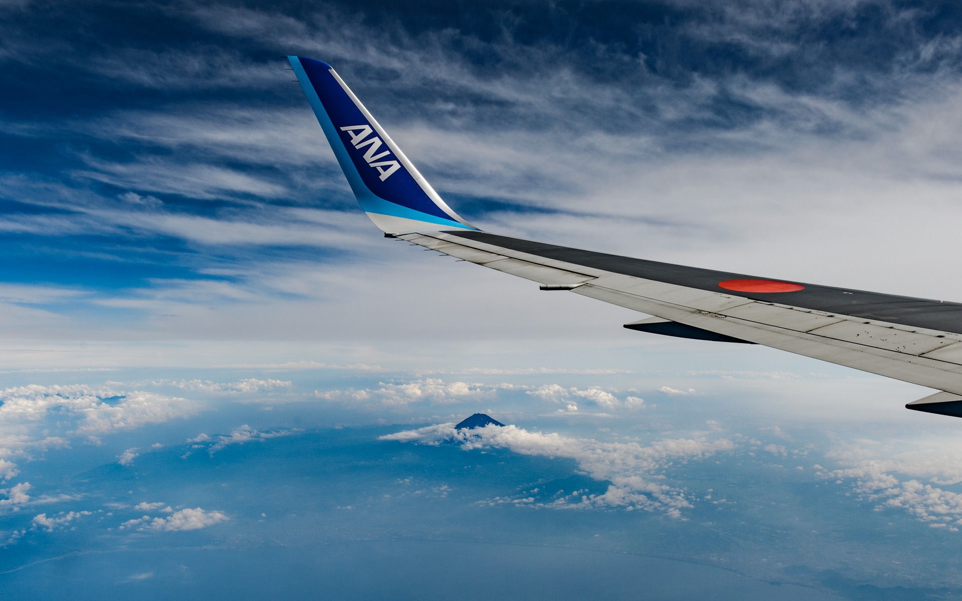
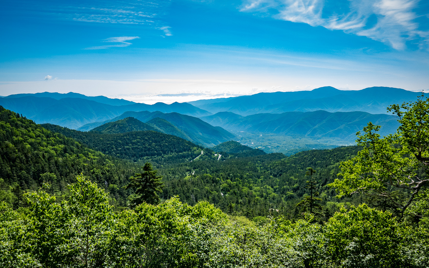
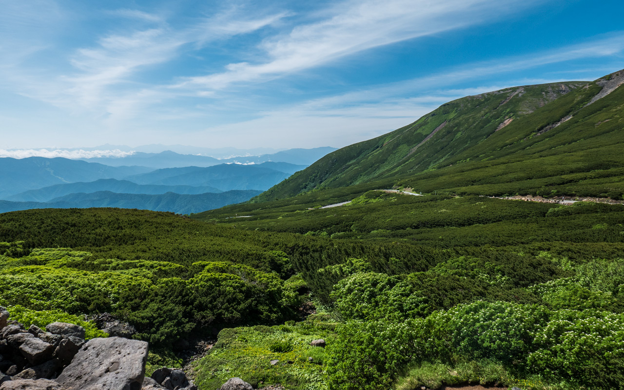
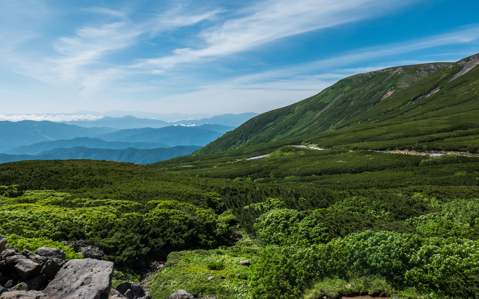
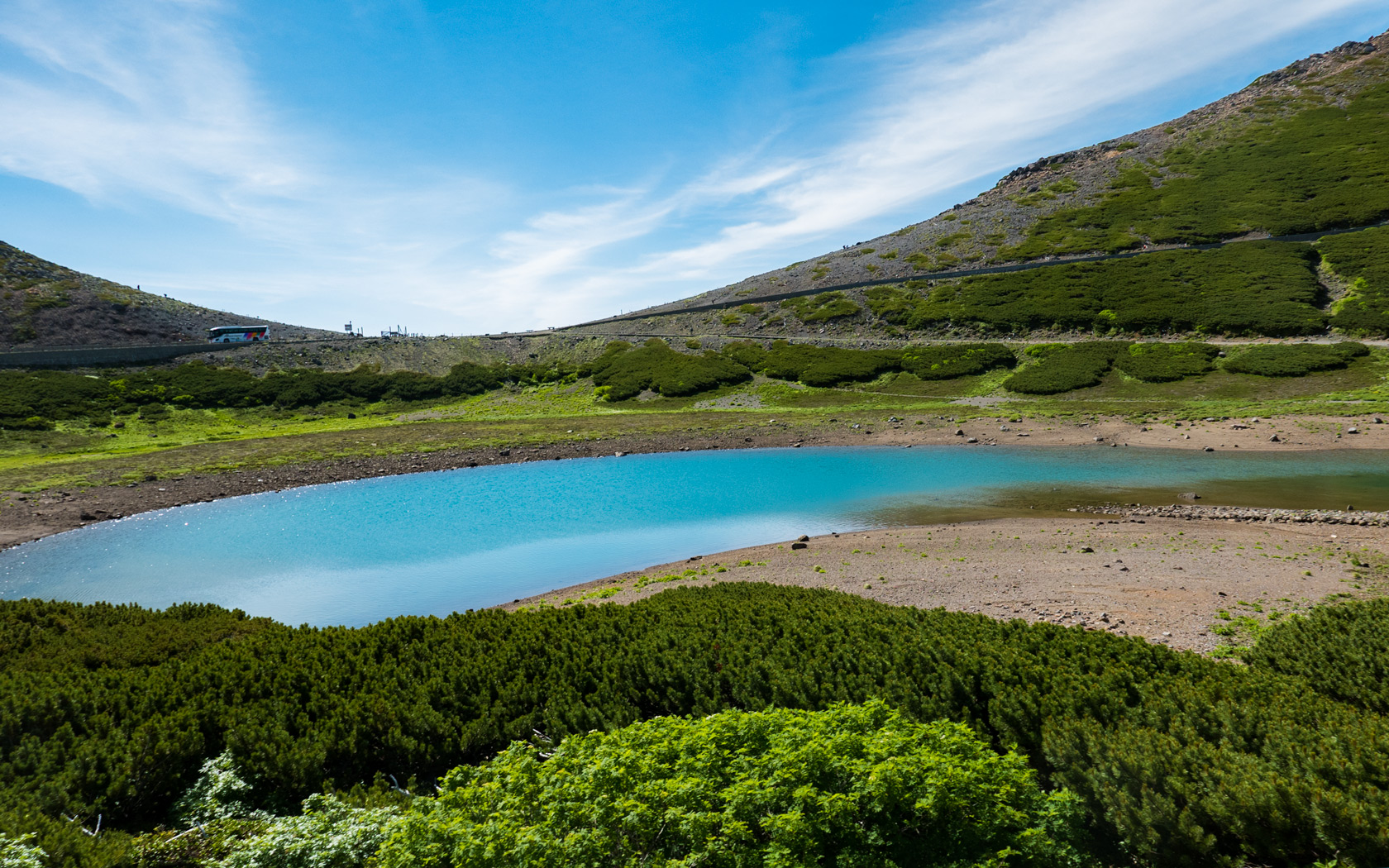