
Jeffrey E.F. Friedl's Blog, page 14
November 25, 2016
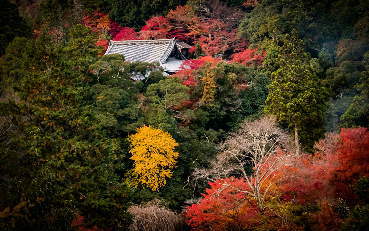
The Back Entrance to Shiga’s Eigenji Temple
Note: this article may not appear properly in news readers.
This article contains interactive aspects that are likely removed by most news readers. Please see this particular article directly on Jeffrey's blog for full functionality.
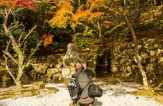
Nikon D4 + Nikkor 24-70mm f/2.8 @ 58mm — 1/400 sec, f/7.1, ISO 500 —
map & image data — nearby photos
Back Entrance
Eigenji Temple (永源寺)
Shiga, Japan
Desktop-Background Versions
1280×800 · 1680×1050 · 1920×1200 · 2560×1600 · 2880×1800
Last week I took a drive out to a new temple that Manseki had recommended as being pretty in autumn.
It did not disappoint. (The “Anatomy of a Selfie” that I posted the other day was taken here.)
It turns out that I rode right by this temple during my summer bicycle ride to
Nagoya. At that time, it took about 2h 40m to get here from home. This time by car, it took about an hour. I made the drive
with Paul, Damien, and a newly-met friend, Adrian Tischler from Australia.
We didn't realize it at the time, but the directions we followed to get there brought us to a
little-used back entrance. There was little traffic as we approached in the morning, but we passed a
gauntlet of parking-lot folks trying to get us to patronize their business. The sheer number of them waiting for the crowds
to arrive didn't bode well for a quiet visit, but it was still early.
Our route left that
behind, and eventually we came across a bridge that offered a nice view.
Nikon D4 + Nikkor 24mm f/1.4 — 1/160 sec, f/3.5, ISO 100 —
map & image data — nearby photos
Bridge
near the temple
Nikon D4 + Nikkor 24mm f/1.4 — 1/500 sec, f/1.4, ISO 100 —
map & image data — nearby photos
Bonus View
from the bridge
Folks visiting via the main entrance would never see this.
Nikon D4 + Nikkor 24-70mm f/2.8 @ 55mm — 1/250 sec, f/7.1, ISO 720 —
map & image data — nearby photos
Nikon D4 + Nikkor 24-70mm f/2.8 @ 24mm — 1/100 sec, f/7.1, ISO 180 —
map & image data — nearby photos
Different Angle
Soon we found a parking area at what looked like the end of the road, so we parked and walked up a pretty
service road toward the temple...
Nikon D4 + Nikkor 24-70mm f/2.8 @ 24mm — 1/100 sec, f/7.1, ISO 900 —
map & image data — nearby photos
Above the Parking Lot
Adrian steadies himself for a shot
Nikon D4 + Nikkor 24-70mm f/2.8 @ 24mm — 1/100 sec, f/7.1, ISO 250 —
map & image data — nearby photos
Nikon D4 + Voigtländer 125mm f/2.5 — 1/200 sec, f/2.5, ISO 100 —
map & image data — nearby photos
Totally Missed Focus
it would have been a nice shot of Adrian
Nikon D4 + Voigtländer 125mm f/2.5 — 1/160 sec, f/2.5, ISO 100 —
map & image data — nearby photos
Slightly Better Focus
but only slightly, of a lady walking to the temple
At the crest of the hill you pay your entrance fee (about 500 yen), then descend into the temple area proper...
Nikon D4 + Voigtländer 125mm f/2.5 — 1/400 sec, f/2.5, ISO 140 —
map & image data — nearby photos
Nikon D4 + Voigtländer 125mm f/2.5 — 1/400 sec, f/2.5, ISO 250 —
map & image data — nearby photos
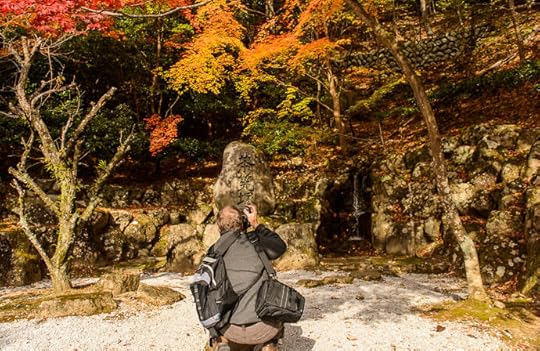
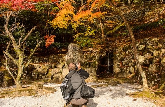
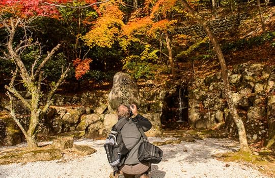
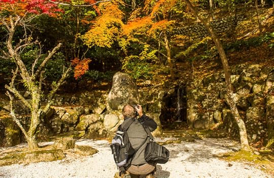
Halfway down, there's a picturesque alcove, a place called a chasenzuka (茶筅塚/ちゃせんづか),
with a huge stone carved with that word (茶筅塚)...
Nikon D4 + Nikkor 24-70mm f/2.8 @ 24mm — 1/400 sec, f/7.1, ISO 2200 —
map & image data — nearby photos
Eigenji Temple's chasenzuka
永源寺の茶筅塚
It's apparently a place where practitioners of the Japanese Tea Ceremony can ceremoniously burn their used tea whisks,
which are made from bamboo and don't last all that long. I guess if you've
spent $100 on a whisk, you want to say goodbye.
I knew that a normal photo wouldn't capture the feeling of the space, so I tried making
a wigglegram for the first time in ages...
div#dDTi3JMPvMPvLdA img { width:690px; height:448px; visibility:hidden; position:absolute; top:0; left:0; border: solid 10px #311}


Animatable Wigglegram (17 frames) — slowly sweep mouse from side to side to view 3D effect
写真の上をマウスで左右にゆっくり動かすと「3D」な感じが出ます。
=i.length)return 0;else return which;}else{if(which=i.length)return i.length-1;else return which}};t=function(event){if(m>0&&((new Date().getTime())-m)R&&s0){f(c(s-1));console.log(s+":delta is "+delta);L=0.05;R=0.2;T=tilt;}}};d.ontouchmove=d.onmousemove=function(e){if(e.touches&&e.touches.length>1)return true;var x=Math.floor((e.clientX||e.pageX)/BW);var which=c(x>l?s+(x-l):s-(l-x));l=x;if(which!=s){m=new Date().getTime();f(which);}return false;};window.addEventListener('devicemotion',t,false)}
It's a bit wonky because I didn't keep my distance from Paul constant. I'm out of practice.
Besides the huge stone with the name carved in it, they also had a little wooden calf-high sign with the name,
so I tried incorporating it into a shot:
Nikon D4 + Nikkor 24-70mm f/2.8 @ 24mm — 1/400 sec, f/7.1, ISO 1400 —
map & image data — nearby photos
I can't quite decide whether it's interesting, or I should just delete it.
Turning again to continue on toward the temple grounds proper, it's only a short distance down
a path until you arrive...
Nikon D4 + Nikkor 24-70mm f/2.8 @ 31mm — 1/400 sec, f/7.1, ISO 640 —
map & image data — nearby photos
To be continued...


November 24, 2016
Group Hanase Climb, and Full Carpet at the Ochiba Shrine
Panasonic LX100 at an effective 24mm — 1/125 sec, f/2.8, ISO 200 —
map & image data — nearby photos
Fallen-Leaf Yoga
(sort of)
at the Ochiba Shrine, Kyoto Japan
岩戸落葉神社(京都市)
Today we did a simple little “Hanase Support” ride, where a few of
us with experience making the climb to Hanase Pass helped out those who have never done it. Lianca and Stephanie made the climb
for the first time, being encouraged by Manseki, Antti, and me.
The southern climb to Hanase Pass is Kyoto's premier
climb, averaging 8.6% for 5.8 km (3.6 miles) of unrelenting grade. Through sheer ignorance I happened to choose
it for my first-ever real bike outing, in the snow and ice of early February last year,
when it took 48 minutes to finish. I've climbed it 27 times since,
with my best now 28:59, done a month ago.
(Antti has done the climb 33 times, including 18 times one day last August when he Everested it!)
On today's trip, Antti accompanied Stephanie, and I rode with Lianca...
Panasonic LX100 at an effective 70mm — 1/125 sec, f/3.2, ISO 200 —
map & image data — nearby photos
Lianca Smiling up Hanase
Panasonic LX100 at an effective 26mm — 1/80 sec, f/1.9, ISO 320 —
map & image data — nearby photos
Half Way
the turnoff to Momoi Pass
Panasonic LX100 at an effective 38mm — 1/125 sec, f/3.2, ISO 200 —
map & image data — nearby photos
Success!
arriving at Hanase Pass (花背峠)
complete in about 41:40
Panasonic LX100 at an effective 24mm — 1/125 sec, f/5.6, ISO 200 —
map & image data — nearby photos
Scooting Down the Other Side
taken while cycling at 24 kph (15 mph)
Panasonic LX100 at an effective 28mm — 1/125 sec, f/2.2, ISO 200 —
map & image data — nearby photos
Panasonic LX100 at an effective 29mm — 1/125 sec, f/3.2, ISO 200 —
map & image data — nearby photos
taken while cycling at 30 kph (19 mph)
Panasonic LX100 at an effective 35mm — 1/125 sec, f/2.8, ISO 200 —
map & image data — nearby photos
Nervous Smile
taken while cycling at 29 kph (18 mph)
Stephanie is a former world-class triathlete,
but is not used to big climbs nor descents, and would prefer to do neither. Nevertheless, she tackled both today,
doing the climb up in 37:29 (11th overall for women).
She really doesn't care for descents, so took her time
and descended at about the same speed I climb. 
November 23, 2016
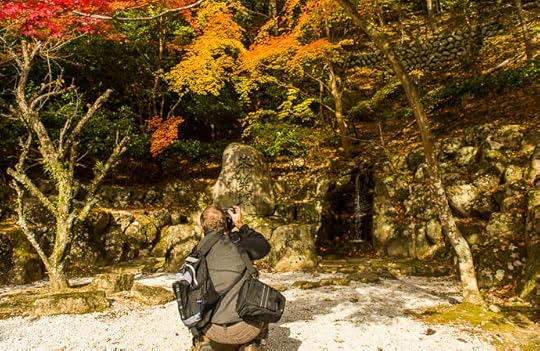
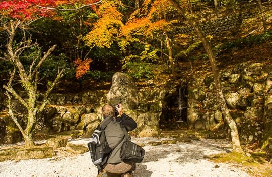
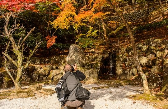
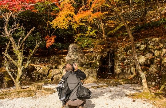
Anatomy of a Selfie
Nikon D4 + Voigtländer 125mm f/2.5 — 1/400 sec, f/2.5, ISO 450 —
map & image data — nearby photos
Compose and Shoot
Last Thursday the 17th, at the Eigenji Temple, Shiga Japan
滋賀県の永源寺、先週の17日
Nikon D4 + Voigtländer 125mm f/2.5 — 1/400 sec, f/2.5, ISO 360 —
map & image data — nearby photos
Return Camera
Nikon D4 + Voigtländer 125mm f/2.5 — 1/400 sec, f/2.5, ISO 400 —
map & image data — nearby photos
Navigate To Result
Nikon D4 + Voigtländer 125mm f/2.5 — 1/400 sec, f/2.5, ISO 400 —
map & image data — nearby photos
Enjoy
November 22, 2016
More on Friday’s Fall-Foliage Outing to the Ochiba Shrine
Panasonic LX100 at an effective 35mm — 1/125 sec, f/5.6, ISO 200 —
map & image data — nearby photos
Ochiba Shrine Nov 18
not peak, but getting closer
This post is a longer version of Friday's “Checking On the Carpet
of Yellow at the Ochiba Shrine”, in which I posted two quick photos from a ride that day to check out the colors at the Iwato
Ochiba Shrine (岩戸落葉神社) in the mountains northwest of Kyoto. I started writing this followup post the next day, but have been
so busy since I'm only finishing it today.
I normally like long rides, I guess to amortize the once-per-ride overhead of dealing with everything (the before and after
of clothes, bike, electronics, data, and self), but I didn't get started until after noon, so I just thought to pop up to see
how the Ochiba Shrine was doing fall-foliage wise.
Along the way up the first climb into the mountains, where there's little traffic, I was surprised to find
Manseki coming the other way. He had just visited the same shrine with his wife.
SC-02H at an effective 26mm — 1/50 sec, f/1.7, ISO 64 —
map & image data — nearby photos
Impromptu Shot
photo by Manseki's wife
I then continued on toward the shrine, and went a bit past to check out a little garden I know to be nearby...
Panasonic LX100 at an effective 75mm — 1/125 sec, f/2.8, ISO 200 —
map & image data — nearby photos
Secret Garden
Kyoto cyclists go by this all the time,
but likely have no idea it's there.
Panasonic LX100 at an effective 62mm — 1/125 sec, f/2.8, ISO 320 —
map & image data — nearby photos
This last one isn't quite as good as this comparable shot
from last year that I posted a few months ago.
Panasonic LX100 at an effective 34mm — 1/125 sec, f/2.8, ISO 200 —
map & image data — nearby photos
Typical Japan
wires, maple, dump truck, thatched farmhouse, guardrail
Panasonic LX100 at an effective 43mm — 1/125 sec, f/4, ISO 200 —
map & image data — nearby photos
Mostly the Same Thing
sans dump truck
Panasonic LX100 at an effective 60mm — 1/125 sec, f/4.5, ISO 200 —
map & image data — nearby photos
What Is the Point of This Ugly Photo?
The point is the yellow in the center background. It's washed out in the sunlight in this photo,
and I guess the scale is hard to grasp, but the yellow ginkgo trees are towering. They're from where
the “Fallen-Leaf Shrine” gets its name.
Panasonic LX100 at an effective 24mm — 1/400 sec, f/5.6, ISO 200 —
map & image data — nearby photos
Same Trees
closer up
I noticed for the first time that the green hedge next to the shrine was partially yellow,
right below where some of the ginkgo branches had dipped down to touch it. It's as if the
yellow was contagious to the shrub:
Panasonic LX100 at an effective 75mm — 1/160 sec, f/5.6, ISO 200 —
map & image data — nearby photos
Chameleon Shrub
It turns out that the yellow section of hedge is actually a different kind of plant
(the leaves look like some kind of mini maple to me, but I dunno whether such a thing
even exists)...
Panasonic LX100 at an effective 75mm — 1/640 sec, f/5.6, ISO 200 —
map & image data — nearby photos
Two Kinds of Leaves
Anyway, I thought it was interesting.
Panasonic LX100 at an effective 24mm — 1/250 sec, f/5.6, ISO 200 —
map & image data — nearby photos
iPad Traffic Mirror Selfie
Panasonic LX100 at an effective 75mm — 1/200 sec, f/5.6, ISO 200 —
map & image data — nearby photos
His Probably Turned Out Better
I took the opportunity to ride a dead-end road that starts near the shrine, diving up into the mountain to a small village,
but otherwise leading nowhere.
It was a pleasant ride on a wonderful day, and I stopped often for photos.
Panasonic LX100 at an effective 24mm — 1/160 sec, f/5.6, ISO 200 —
map & image data — nearby photos
Steep Driveway
Panasonic LX100 at an effective 25mm — 1/80 sec, f/1.8, ISO 250 —
map & image data — nearby photos
Typical Rural Japan
Panasonic LX100 at an effective 58mm — 1/125 sec, f/3.2, ISO 200 —
map & image data — nearby photos
Farmer
Panasonic LX100 at an effective 28mm — 1/125 sec, f/3.2, ISO 200 —
map & image data — nearby photos
Farmer's House
just lovely
Panasonic LX100 at an effective 75mm — 1/125 sec, f/4, ISO 200 —
map & image data — nearby photos
Just Old
no fire damage is visible, so it's probably just old and neglected
I also tried a few little offshoots that were likely forestry or dam-construction roads.
Panasonic LX100 at an effective 24mm — 1/125 sec, f/1.7, ISO 320 —
map & image data — nearby photos
Pleasant
Panasonic LX100 at an effective 32mm — 1/100 sec, f/2.2, ISO 200 —
map & image data — nearby photos
Architecture Unburdened
with the constraints of right angles
Panasonic LX100 at an effective 28mm — 1/40 sec, f/2.1, ISO 3200 —
map & image data — nearby photos
Tempting-Looking Road
once you reach the middle of nowhere, find the least-used offshoot and you'll be here
Panasonic LX100 at an effective 24mm — 1/60 sec, f/1.7, ISO 800 —
map & image data — nearby photos
Slippery Moss
with some road peeking through
Panasonic LX100 at an effective 34mm — 1/80 sec, f/2.3, ISO 800 —
map & image data — nearby photos
End of My Line
road turns to full-on gravel from here
Panasonic LX100 at an effective 24mm — 1/60 sec, f/1.7, ISO 500 —
map & image data — nearby photos
Heading Back Down
Panasonic LX100 at an effective 31mm — 1/80 sec, f/2.2, ISO 200 —
map & image data — nearby photos
Tall, Encroaching Grass
After exploring all the nooks and crannies the dead-end road beyond the shrine had to offer, I headed home via the
Takao area of Kyoto, which has some very nice temples,
the most famous of which is Jingoji, which appeared on my blog here,
and Kosanji (often incorrectly referred to as “Kozanji”), which appeared here.
Anyway, even the drive through on National Route 162 is pretty, and that's all I saw this time through...
Panasonic LX100 at an effective 31mm — 1/80 sec, f/2.2, ISO 200 —
map & image data — nearby photos
Village Between the Temples
Panasonic LX100 at an effective 24mm — 1/60 sec, f/1.7, ISO 400 —
map & image data — nearby photos
Rust-Colored Leaves
and rust-colored rust
Panasonic LX100 at an effective 75mm — 1/125 sec, f/2.8, ISO 800 —
map & image data — nearby photos
Roof
Saimyoji Temple (西明寺)
Finally I did the a little side climb
to a hilltop cemetery. It's short — just half a mile (600m) — but it averages 15% and
the final 110m is 23~25%.
Panasonic LX100 at an effective 41mm — 1/100 sec, f/2.5, ISO 200 —
map & image data — nearby photos
View To Die For
Narutaki Reien Cemetery (鳴滝霊園)
On the way home I stopped by a hotel where a friend had a photo exhibition opening...
Panasonic LX100 at an effective 60mm — 1/50 sec, f/2.8, ISO 3200 —
map & image data — nearby photos
I felt a bit odd showing up in cycling gear, but it was fine and so where the photos.
In the end my “short little ride” turned out to be 77km (48mi),
which isn't short, but not quite up to recent par. The median of the last 30 days I've ridden (more than 25km)
is 101km.
November 18, 2016
Checking On the Carpet of Yellow at the Ochiba Shrine
Panasonic LX100 at an effective 50mm — 1/320 sec, f/5.6, ISO 200 —
map & image data — nearby photos
Getting Close, but Not Yet Peak
Iwato Ochiba Shrine (岩戸落葉神社), Kyoto Japan
I took a short ride out to check out the status of Ochiba Shrine. It's still a few days... maybe three, maybe five... from peak. It seems early this year. When I first posted about it five years ago,
it was from a Dec 2 visit.
Yet, the next year I visited on Nov 14, and it was about the same as it
was today (Nov 18). Maybe it takes time, because the same year I posted one of my
first wigglegrams from the shrine, with full-carpet photos taken on Nov 25.
Even more surprising to me is that last year, photos from Nov 10
(on an article posted Nov 26; don't be fooled by the article date) show a pretty full carpet. So I don't really know what's
“normal” for this shrine. They do have a special evening light-up event tomorrow (Nov 19), so perhaps that indicates
the traditional peak?
Anyway, I'll certainly have to check in again next week.
I returned through the Takao area of north-west Kyoto, which hosts two famous temples
(the Kosanji Temple / 高山寺, and the Jingoji Temple / 神護寺), visited in prior
posts such as this,
this and this,
among others.
It was too late to visit them on this trip, and I probably wouldn't with th bike anyway (I wouldn't feel comfortable
leaving the bicycle as I ventured in), but I did snap a photo from the road:
Panasonic LX100 at an effective 72mm — 1/125 sec, f/2.8, ISO 1600 —
map & image data — nearby photos
Buried in Color
Saimyoji Temple / 高尾の西明寺
Desktop-Background Versions
1280×800 · 1680×1050 · 1920×1200 · 2560×1600 · 2880×1800
It turns out that it's of a temple that I didn't realize was separate from the others, called the Saimyoji Temple.
I'll have to check it out some day.
To be continued...
November 16, 2016
Ninth Anniversary of my Lightroom Plugin Work
Nikon D4 + Nikkor 24-70mm f/2.8 @ 24mm — 1/200 sec, f/6.3, ISO 6400 —
map & image data — nearby photos
Joshokoji Temple (常照皇寺)
Kyoto, Japan
Today is the nine-year anniversary of my plugins for Adobe Lightroom. It was on November 16, 2007 that I released my
first ones, export plugins for Zenfolio and for SmugMug.
Now, nine years later, after many having been added and a few having been retired, I have
about 45 plugins available.
Today I released a few minor updates, including a new
“Publish At...”
feature of my Bag-o-Goodies plugin. It lets you schedule a publish operation for later in the evening.
I lost track of the count of updates I made prior to Lightroom 2, but since then, considering only the plugins
currently available, I've made 4,189 updates (counting today's).
Nikon D4 + Nikkor 24-70mm f/2.8 @ 60mm — 1/800 sec, f/8, ISO 320 —
map & image data — nearby photos
Random roadside scene
Kyoto, Japan
November 8, 2016
Update on my Bike-Mount Failure: K-EDGE Comes Through
Nikon D4 + Voigtländer 125mm f/2.5 — 1/800 sec, f/5.6, ISO 6400 —
image data
Giving It Another Try
K-EDGE has restored my trust in its mount
Two weeks ago in “Pleasant Social Ride to Onyu Pass”
I reported about how the K-EDGE bicycle mount for my cycling computer and front video camera had failed on a bumpy downhill. I had been using a K-EDGE Garmin Mount XL to hold a Garmin Edge 820 and a Cycliq Fly12.
The summary of this followup is that I am now using another copy of the same mount, and that I think it can be trusted if
you don't touch the two screws joining the halves of the mount together. Details follow.
In the post two weeks ago, I included this photo showing the bike-side half of the mount with part of a
sheared-off bolt sticking out:
Nikon D4 + Venus 60mm Super Macro f/2.8 — 1/320 sec, f/5.6, ISO 6400 —
image data
Fate of the Earlier Mount
one bolt gone, the other ripped in half
Modern mounts from K-EDGE see to come in halves joined by two screws:
Nikon D4 + Voigtländer 125mm f/2.5 — 1/320 sec, f/5.6, ISO 6400 —
image data
Junction Between the Halves
Nikon D4 + Venus 60mm Super Macro f/2.8 — 1/640 sec, f/5.6, ISO 3600 —
image data
Accessory Side of the Mount
with holes for two screws
I suppose this two-part design makes it easier to offer a wide variety of bike-mount solutions, since
they don't have to design and manufacture every permutation of “attaches this way” and “supports these accessories”. Having
mutually-interchangeable halves lets them mix and match on the fly.
To recap about the failure I experienced two weeks ago, while riding down a very fast, bumpy descent,
the whole thing appeared to snap in half at a particularly nasty bump. Inspecting it later showed that
one of the pair of bolts had snapped, and that the other was missing. My guess is that one bolt had
worked loose at some point, leaving all the stresses to the other bolt, now compounded by the extra leverage the lack of the
second bolt created.
A few things lend credence to my theory. One is that some weeks/months back, during a less-bumpy ride, I had noticed that one of the bolts had worked loose. I was happy to catch it before it got lost, and tightened it up. So, a bolt working
loose is not without precedent.
Second is that the video of the descent prior to failure was ridiculously shaky... the extra “give” from the lost bolt showing up in the result.
What still perplexes me, though, is that after noticing the loose screw the first time, I used Loctite 222 to secure them both. I think that there
are more different Loctite products than atoms in the universe, but this seemed to be an appropriate one for this situation. Yet,
the screw was nowhere to be found. (Had the first screw also broken in half, part of it would have remained in the mount just as
part of the second screw remained in the mount.)
K-EDGE mounts are well respected, and the one
I had is highly rated at Amazon by what seem to be real reviews. The bolts
aside, it seems rock solid, so I sent them a note asking whether they had
a unibody version of the mount.
I didn't expect much. A different company (TiGRA), for example, didn't even response when I reached
out to them after their mount disintegrated, sending my iPhone 6+
smashing into the pavement.
But K-EDGE responded right away. They noted that they tend to see this kind of separation after a
crash. I suppose that in the case of a crash, such a
separation is a feature: the mount separates upon impact, lowering the stress on your
much-more-pricey bike and accessories (or, more importantly, giving way to your body being flung about instead of impaling a cycling computer in your gut).
In my note to them I didn't ask for anything but information, but in their first response they asked me to fill out a warranty/return form, and asked for more details about the failure. I sent them
a bunch of photos and the video that my Fly12 was taking at the time of the failure.
Their second response, which came equally quickly, is a model for excellent customer relations. They had never seen a failure
like this, which one supposes would make them skeptical of the story they were hearing, but if they harbored any suspicion, they
kept it to themselves. First they addressed the current situation: they said they were expressing me two copies of the mount (at
their expense, to my address in Japan, even though I had bought the mount in America), which I could do with what I wanted. They
noted that if I didn't trust the mount, I could sell them to fund whatever mount solution I might decide to go with. That last bit
about selling them showed me that they weren't just going through the “give him something to shut him up” motions. They truly
cared. Seth Godin would be proud. I was impressed.
Then on to why the mount failed in the first place. They said that thought that perhaps
“the bolts were over torqued causing them the break under extreme stress”.
This mention of “over torqued”
obviously means "we think you must be inhumanly strong... Superman must cower in your presences, and women must swoon at your devastating good looks". It's a plainly-superficial attempt to flatter, and, I must say, remarkably effective. 
November 7, 2016
Approaching Onyu Pass
Nikon D4 + Nikkor 70-200mm f/2.8 @ 70mm — 1/320 sec, f/9, ISO 720 —
map & image data — nearby photos
near Onyu Pass (おにゅう峠の近く)
in the mountains way north of Kyoto, Japan
I just got back from yet another ride to Onyu Pass, the fourth in half as many weeks.
(The first three were blogged about
here,
here,
and here.)
This time, like the first, I went with a group of friends. Also like the first, I brought along the real camera (Nikon D4),
but this time I also brought some real lenses. I haven't looked at all the photos yet, wanted to post a few.
Nikon D4 + Nikkor 70-200mm f/2.8 @ 70mm — 1/320 sec, f/6.3, ISO 320 —
map & image data — nearby photos
Nikon D4 + Nikkor 70-200mm f/2.8 @ 125mm — 1/320 sec, f/11, ISO 1100 —
map & image data — nearby photos
To be continued...
November 5, 2016
200km Fast Sprint to Onyu Pass + Obama + Gonami
Panasonic LX100 at an effective 54mm — 1/125 sec, f/4, ISO 200 —
map & image data — nearby photos
Autumn Encroaches on Onyu Pass
Onyu Pass (おにゅう峠)
Monday, Oct 31, 2016
So, I made a third cycle ride in a row up to Onyu Pass the other day.
The first trip on a Monday was a lazy social ride
of 149km (93mi). Later that week I did a faster solo ride
that topped out at 165km (103mi).
This third trip the Monday following the first ended up being 206km (128mi).
I had three goals for the ride. The first was to improve my time on
the 58km (36mi) mountainous stretch
from the Ichihara area of Kyoto to the top of Onyu Pass. This involves a mile of elevation gain
(more precisely, 1,605m or 5,266') including the major climbs up Hanase Pass, Nomi Pass, and of course the final Onyu Pass.
Panasonic LX100 at an effective 24mm — 1/125 sec, f/5.6, ISO 200 —
map & image data — nearby photos
Above Onyu Pass
guardrail at left is the climb from the Kyoto side; at right is down toward the sea
It's not an uncommon route, I think, but the segment at
Strava shows only 22 matching attempts. I guess one needs a high-quality GPS unit and some luck for the full 58km of mountains
to actually match the segment track.
Moreover, the entire segment of three major climbs is not something one would normally try to
do in one shot, but rather pause along the way between the major climbs.
I mention all this to explain why I
had the KOM (the “King of the Mountain”... the fastest
registered time) going into this. My time of three hours 17 minutes wasn't all that fast and included 16 minutes spent fixing a flat. Still, when I did it was better than #2 by more than half an hour.
Fast forward to this past Monday when I started this ride, someone had moved to within just four
minutes of my KOM time. Barring another flat tire I knew I'd pull farther ahead, so I
gave it a good go....
I thought I might PR (make a new personal record) on the first and biggest climb to Hanase Pass, but I
actually missed it by a
whopping 10%. I didn't make PRs on any of the climbs, but did well on the connecting segments
and didn't make any rest stops (or any stops at all... the wheels on the bike never stopped turning for the entire segment). I finished in just under two hours 41 minutes, improving my previous time by 37 minutes.
Any number of my friends could beat this if they made any effort to do so, but at least now it's less of a
low-hanging fruit.
Anyway, I retraced my steps back down from Onyu Pass for a while to where I
could take the photo that leads this post. Last year on my blog I included a summer view from the same vantage point.
Panasonic LX100 at an effective 24mm — 1/320 sec, f/5.6, ISO 200 —
map & image data — nearby photos
Wider View
of the leading photo
Panasonic LX100 at an effective 50mm — 1/125 sec, f/5, ISO 200 —
map & image data — nearby photos
Doesn't Quite Work
trying to get the twisty road in the background and bike in the foreground
Goal #2 for the ride was to explore the northern descent from Onyu Pass. I'd climbed from the south seven times, but had always returned back down the south
toward Kyoto. This time I wanted to head north, toward Obama and the sea.
Panasonic LX100 at an effective 24mm — 1/160 sec, f/5.6, ISO 200 —
map & image data — nearby photos
Gravel Toward the South
The road turns to gravel at the pass, and I worried about trying such a steep descent on gravel with 25mm road-bike tires,
but lately had been hearing that it was doable, so I gave it a shot.
Panasonic LX100 at an effective 58mm — 1/125 sec, f/4.5, ISO 200 —
map & image data — nearby photos
Discarded Ribbon
I was surprised to find that though the descent starts with gravel, there are many paved sections,
so it wasn't nearly as bad as I thought.
It also appeared to suffer a lot of guardrail-crushing avalanches.
Panasonic LX100 at an effective 44mm — 1/125 sec, f/4, ISO 200 —
map & image data — nearby photos
Panasonic LX100 at an effective 75mm — 1/125 sec, f/3.5, ISO 200 —
map & image data — nearby photos
Panasonic LX100 at an effective 75mm — 1/125 sec, f/4.5, ISO 200 —
map & image data — nearby photos
Halfway Down
looking north
( we'll be passing by the roof in the center of the photo soon )
Panasonic LX100 at an effective 24mm — 1/125 sec, f/3.5, ISO 200 —
map & image data — nearby photos
One of the Gravel Areas
these gravel areas are not bad, road-bike wise
Panasonic LX100 at an effective 24mm — 1/125 sec, f/2.2, ISO 200 —
map & image data — nearby photos
Water Stop
Since I had done the dash from Kyoto to Onyu Pass without stopping, I had only the one bottle of water with me, which I finished off
while resting at the top. Lacking stores and vending machines in the middle of nowhere, I kept an eye out for a road-side stream I could fill up at, and finally found one 20 minutes into the descent (4½ hours into the ride).
Panasonic LX100 at an effective 24mm — 1/125 sec, f/5, ISO 200 —
map & image data — nearby photos
Freaky Fake Rock Wall
likely covering a real rock wall
Panasonic LX100 at an effective 41mm — 1/125 sec, f/4, ISO 200 —
map & image data — nearby photos
First Sign of Civilization
the rooftops seen in “Halfway Down” above
Panasonic LX100 at an effective 35mm — 1/125 sec, f/2.3, ISO 200 —
map & image data — nearby photos
Typical Rustic Scene
Panasonic LX100 at an effective 32mm — 1/125 sec, f/2.2, ISO 200 —
map & image data — nearby photos
Mossy Dead End
I had scoped out the satellite photos for offshoot roads, but all were either gravel, or just
sort of became nothing like this one.
Panasonic LX100 at an effective 34mm — 1/125 sec, f/2.5, ISO 200 —
map & image data — nearby photos
Half a House
along the side of the road
Panasonic LX100 at an effective 75mm — 1/125 sec, f/2.8, ISO 400 —
map & image data — nearby photos
If Buildings Could Talk
I imagine this one could tell quite a story
Panasonic LX100 at an effective 24mm — 1/125 sec, f/3.5, ISO 200 —
map & image data — nearby photos
Lovely Mountain Road
Panasonic LX100 at an effective 24mm — 1/125 sec, f/2.5, ISO 200 —
map & image data — nearby photos
Panasonic LX100 at an effective 28mm — 1/125 sec, f/3.5, ISO 200 —
map & image data — nearby photos
Panasonic LX100 at an effective 28mm — 1/125 sec, f/3.5, ISO 200 —
map & image data — nearby photos
Panasonic LX100 at an effective 28mm — 1/125 sec, f/3.2, ISO 200 —
map & image data — nearby photos
Eventually I emerged from the mountains into the farms surrounding the city of Obama, and quickly made my way to
the standard “I made it to Obama” photo spot...
Panasonic LX100 at an effective 24mm — 1/320 sec, f/5.6, ISO 200 —
map & image data — nearby photos
I Made It To Obama
Mermaid Beach (人魚の浜海水浴場)
Panasonic LX100 at an effective 31mm — 1/125 sec, f/5.6, ISO 200 —
map & image data — nearby photos
Impressed With My Stats
This was my fourth time to ride to/through Obama from Kyoto. The first time was last July. The second time was this July. The third time was early last month,
and this fourth time was last Monday.
Panasonic LX100 at an effective 24mm — 1/125 sec, f/5.6, ISO 200 —
map & image data — nearby photos
Farmer Works His Fields
On the way home I decided to take the road that goes over Gonami Pass, a road I took on the way to
Obama on my first two trips there, but I'd not yet taken the opposite direction. I took my sweet time on it, stopping for photos and such, and generally just going slowly.
Panasonic LX100 at an effective 24mm — 1/125 sec, f/1.7, ISO 200 —
map & image data — nearby photos
Pretty Park Area
that I normally see only in a blur while speeding down this descent
Panasonic LX100 at an effective 24mm — 1/60 sec, f/1.7, ISO 800 —
map & image data — nearby photos
Standard “Japan Mountain Road” Pretty
Panasonic LX100 at an effective 24mm — 1/125 sec, f/1.7, ISO 250 —
map & image data — nearby photos
Cresting Gonami Pass
五波峠
taken while cycling at 16 kph (10 mph)
This is normally a spot to pause to rest and take photos (like this
and this), but having spent a lazy hour making the climb to the top, I decided to not waste time and
zip down. Got the KOM for the descent.
From there perhaps the most direct way home would have been over Sasari and Hanase Passes, but having recently
climbed Sasari Pass thrice in one ride, and
having recently climbed and descended Hanase Pass in the dark on two recent longer-than-expected rides
(this and this), I decided to take the only other route available, through Miyama.
Panasonic LX100 at an effective 65mm — 1/125 sec, f/2.8, ISO 500 —
map & image data — nearby photos
Passing Through Miyama
美山
Another reason I didn't want to go the other direction is that it would have meant the last 20km or so
would have been the same as the first 20km, resulting in the track on the map looking
like this. (That's Neil Holt's ride
two days before mine, resparking the idea to try the northern descent from Onyu, and giving me the
idea to return via Gonami.) It's stupid to care what the track looks like on the map,
but I prefer big loops instead of lollipop-shaped “loop on a stick” tracks.
Anyway, two hours later I'm descending into Kyoto from Kyomi Pass, and am surprised to see the lights
of the city flickering behind a thin veil of trees for almost the entire descent. During the day,
one can see the city only through one or two brief breaks in the trees.
Panasonic LX100 at an effective 65mm — 1/8 sec, f/2.8, ISO 3200 —
map & image data — nearby photos
Descending Kyomi
By the time I'd rolled into the city I had about 200km (125mi) under my belt, and my legs were sore,
so I stopped by Ken-chan's clinic for a wonderful (and wonderfully-painful)
massage. It did wonders. While there, I developed a craving for chicken karaage,
so headed off to a great hole-in-the-wall place I had been to years ago, after
this wine-tasting event.
My legs felt great, but sadly, the restaurant had closed in the intervening years, so I returned to
a place closer to home and ate two
full portions. It was totally delicious.
My legs were killing me the next day.
So, that was three trips to Onyu Pass in a week. It looks like some friends are going next Monday, so
I'll probably ride along with them.
November 1, 2016
A Solo Version of The Recent Social Ride to Onyu Pass
Panasonic LX100 at an effective 75mm — 1/320 sec, f/5.6, ISO 200 —
map & image data — nearby photos
Really Windy
note the completely-horizontal wind sock just right of center
( it's actually a koinobori, but still blown horizontal by the wind )
After the really pleasant social ride to Onyu Pass most of the way toward
the ocean, far north of Kyoto the other day, I thought to more or less do the same ride again by myself, to do some things that
would be inappropriate on a social ride: ride fast, and pause to explore tangential areas.
I started off zipping up and over Hanaore Pass the 40+km (~26 miles) to the village of Kutsuki in about an hour forty five minutes
(as opposed to two and a half hours on the social ride), then immediately lost any gains in the schedule to some exploring...
Panasonic LX100 at an effective 24mm — 1/125 sec, f/3.2, ISO 200 —
map & image data — nearby photos
Road Off to the Right
I wonder where you go...
I knew from previous geeking over satellite photos that there were some roads in this area that appeared to climb up into the
mountains a short while, and that this was one of them. Other than that, I didn't know what to expect, so just took it to find
out.
Panasonic LX100 at an effective 24mm — 1/125 sec, f/5.6, ISO 200 —
map & image data — nearby photos
Up Up Up
I used the in-camera indicator to make sure the camera was exactly level for this picture,
and perhaps if you remind yourself that while staring at the center of the frame, the steepness
of the road will become apparent. Or maybe not.
It turned out to be 1km at 10%, which is steep but not crazy.
(The segment is 994 meters long, which of course in Strava's weird-math universe rounds to “0.9km”.) The road surface was lovely.
The road abruptly ends at what looks like two gravel parking lots, and continues as a gravel path up into the mountain.
The two “gravel parking lots” are really the former locations of buildings (some kind of prefectural nature center),
but now that the places are cleared, they really don't want folks parking on them... they blocked off the entrances
with a mound of dirt, bollards, and rope:
Panasonic LX100 at an effective 35mm — 1/250 sec, f/5.6, ISO 200 —
map & image data — nearby photos
Entrance Denied
Bird photographers were parking along the road to then walk up the gravel path. It would have been nice to have these areas open.
Just a little bit before the end of the pavement, there's a tiny road running off to the north....
Panasonic LX100 at an effective 27mm — 1/125 sec, f/3.5, ISO 200 —
map & image data — nearby photos
I Wonder Where This Goes
Panasonic LX100 at an effective 24mm — 1/60 sec, f/1.7, ISO 320 —
map & image data — nearby photos
Very Steep
but at least it's wet and slippery
Panasonic LX100 at an effective 28mm — 1/80 sec, f/2.1, ISO 640 —
map & image data — nearby photos
Descent into Richness
the area had such a lovely, earthy mood, with wonderful light
And then suddenly...
Panasonic LX100 at an effective 28mm — 1/160 sec, f/5.6, ISO 200 —
map & image data — nearby photos
Suspension Bridge
オグラス山吊橋
Panasonic LX100 at an effective 65mm — 1/160 sec, f/5.6, ISO 200 —
map & image data — nearby photos
Still Windy
path-marking ribbon fluttering horizontally
Panasonic LX100 at an effective 50mm — 1/125 sec, f/5, ISO 200 —
map & image data — nearby photos
As Thick as my Arm
Panasonic LX100 at an effective 75mm — 1/125 sec, f/3.2, ISO 200 —
map & image data — nearby photos
Looks Like a Toy
lack of small details make this huge anchor look like a toy
Panasonic LX100 at an effective 67mm — 1/125 sec, f/4.5, ISO 200 —
map & image data — nearby photos
Bridge Plaque
“Ogurasu Suspension Bridge”
March 1990
Panasonic LX100 at an effective 24mm — 1/250 sec, f/5.6, ISO 200 —
map & image data — nearby photos
Old Instructions
The “400m to the right” place is now an unaccessable parking lot,
so what will I find 600m to the left?
Let's find out...
Panasonic LX100 at an effective 24mm — 1/125 sec, f/2.8, ISO 200 —
map & image data — nearby photos
Up Up Up
Panasonic LX100 at an effective 25mm — 1/125 sec, f/5, ISO 200 —
map & image data — nearby photos
Flattening Out
but still feels like the middle of nowhere
Panasonic LX100 at an effective 25mm — 1/125 sec, f/5, ISO 200 —
map & image data — nearby photos
Civilization
opens out into a park area with a baseball field
グリーンパーク
Panasonic LX100 at an effective 28mm — 1/125 sec, f/2.1, ISO 200 —
map & image data — nearby photos
Awesome Climbing Area
Panasonic LX100 at an effective 28mm — 1/125 sec, f/3.5, ISO 200 —
map & image data — nearby photos
Bocce-Ball Players
Panasonic LX100 at an effective 35mm — 1/125 sec, f/5.6, ISO 200 —
map & image data — nearby photos
Roller Slide!!
smaller version of this kind of awesome
( sadly, it looks too small for me to even try )
Panasonic LX100 at an effective 24mm — 1/125 sec, f/5, ISO 200 —
map & image data — nearby photos
Massive Structure Covering.... Nothing
So, that was a fun place to explore. Heading back toward the bridge, I came to a place where
the road diverged in the yellow wood...
Panasonic LX100 at an effective 24mm — 1/125 sec, f/5, ISO 200 —
map & image data — nearby photos
The first time by I'd looked down the other path as far as I could to where it bent in the undergrowth, but left it for another day,
but now that I was right back here, I thought I'd actually take it. It did not disappoint.
Panasonic LX100 at an effective 24mm — 1/125 sec, f/3.2, ISO 200 —
map & image data — nearby photos
Fabulous Toilets
Panasonic LX100 at an effective 28mm — 1/125 sec, f/3.5, ISO 200 —
map & image data — nearby photos
Spacious Rest Area
Panasonic LX100 at an effective 24mm — 1/125 sec, f/3.2, ISO 200 —
map & image data — nearby photos
Road Turns to Gravel
so I turned around
I retreated back across the bridge, up the short super-steep super-wet section (somehow safely), then
down the initial “where does this go?” climb, and continued on matching the route from the other day's social ride.
Panasonic LX100 at an effective 33mm — 1/250 sec, f/5.6, ISO 200 —
map & image data — nearby photos
Crossing Into Kutsuki Village
After a short stop at the only convenience store for miles around, I
made the Ohikodani climb a bit faster
than on the social ride, though at 23½ minutes, still more than two minutes slower than Ionut did.
A hiking trail crosses the at the road pass, climbing up the mountain on both sides of the road. I climbed up the
southern side for a bit, yielding a nice view:
Panasonic LX100 at an effective 24mm — 1/250 sec, f/5.6, ISO 200 —
image data
After descending back down to the main road, I made the 10km slog mostly up hill to the base of the day's main event,
the climb to Onyu Pass. I gave it a good go. It was quite windy on the open road, but during the climb
there was wind only on some of the hairpins, dropping off soon after. Wasn't too bad.
Panasonic LX100 at an effective 52mm — 1/160 sec, f/5.6, ISO 200 —
map & image data — nearby photos
Onyu Pass
おにゅう峠
I was very happy to better my previous time by two minutes,
setting a new PR at 22:22. Overall it's only 20th best,
though out of all riders 85kg (187lb) or above, I'm the better.
Jeffrey E.F. Friedl's Blog

- Jeffrey E.F. Friedl's profile
- 14 followers

