
Jeffrey E.F. Friedl's Blog, page 13
January 12, 2017
Cycling Through Bamboo Groves and Up Steep Mountain Slopes
I had a long and interesting bicycle ride down to Osaka last weekend that I've been wanting to write about,
and I thought I might finally get around to it yesterday, but I went on a ride instead. Today, I'll
just share some pictures from yesterday's shorter (76km/48mi) ride
(view at Strava).
Panasonic LX100 at an effective 24mm — 1/400 sec, f/5.6, ISO 200 —
map & image data — nearby photos
Destinations One and Two
the hill in the foreground and the mountain in the background
( they don't look like much from here )
First I visited a bump of a hill covered in bamboo and bamboo farming, with quaint roads running here and there through it.
Panasonic LX100 at an effective 24mm — 1/125 sec, f/2, ISO 200 —
map & image data — nearby photos
Entrance to the Bamboo Forest
( one of several )
Panasonic LX100 at an effective 24mm — 1/125 sec, f/1.7, ISO 640 —
map & image data — nearby photos
Road Sliced Through the Grove
Panasonic LX100 at an effective 24mm — 1/125 sec, f/1.7, ISO 800 —
map & image data — nearby photos
I didn't know what to expect when I got to the bamboo-grove hill (“mountain” is too much for this), but the road I happen to
have entered on started off with quite the little climb, 300m (330yd) at 15%. The two photos above are from that road. I guess it's not well known, because I made a Strava segment for it and
only seven people had ridden it prior. A shame.
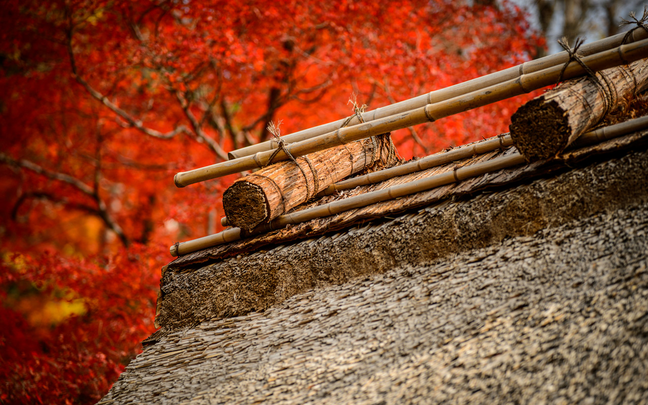
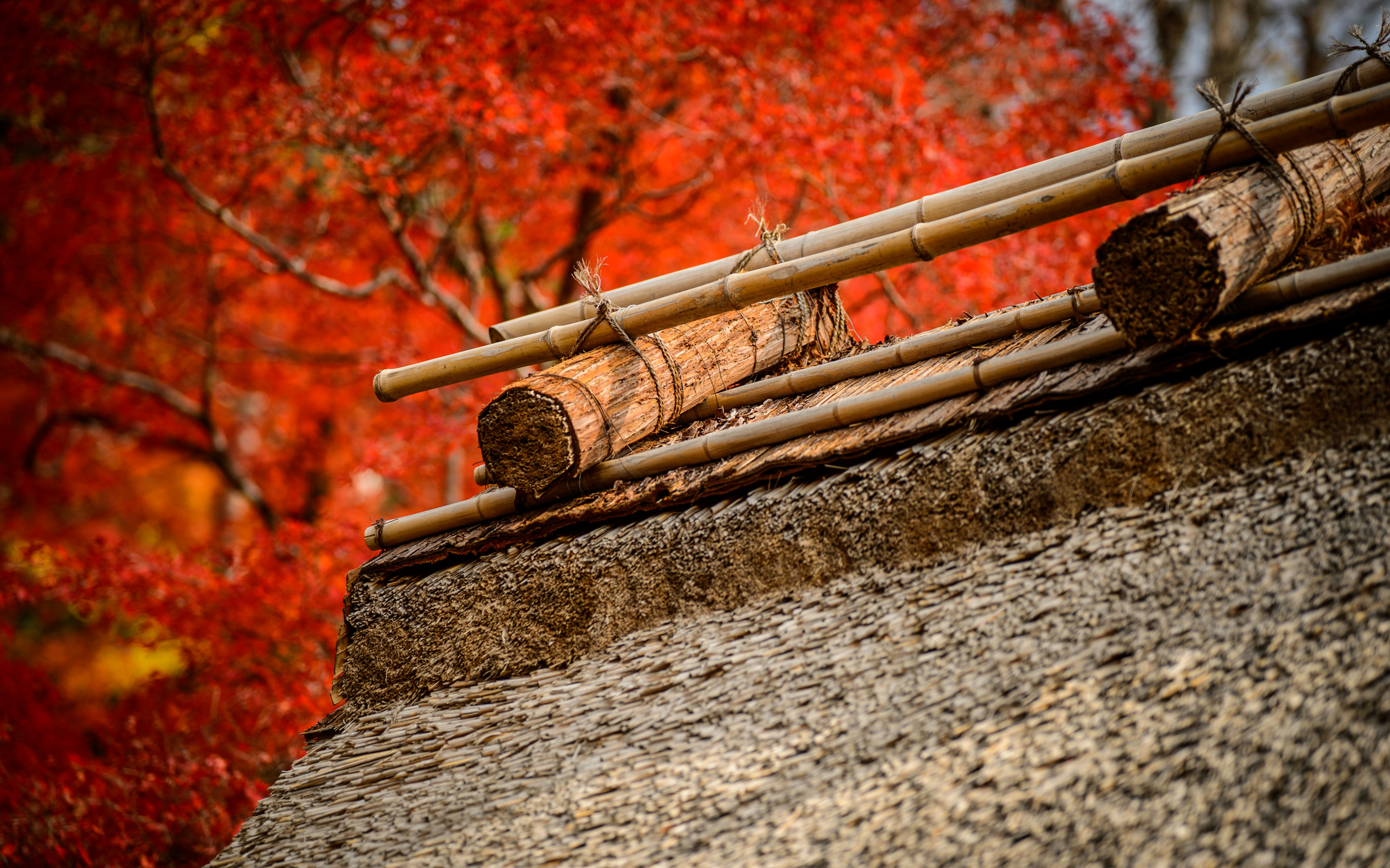
Once you're up top, you can see bamboo put to use with various fence designs...
Panasonic LX100 at an effective 24mm — 1/125 sec, f/2, ISO 200 —
map & image data — nearby photos
Panasonic LX100 at an effective 24mm — 1/125 sec, f/3.2, ISO 200 —
map & image data — nearby photos
Each design is explained a bit with little signboards. The one below describes the photo above,
along the lines of “infinitely rolling waves”...
Panasonic LX100 at an effective 35mm — 1/125 sec, f/4, ISO 200 —
map & image data — nearby photos
This was my first visit by bicycle, but I'd actually visited part of this grove some years ago by scooter, a few of the photos
from that trip later appearing on “Photos of Farming in Japan
for Captain Bill” three years ago.
This time by bicycle I made sure to do all the roads. It was nice.
Panasonic LX100 at an effective 35mm — 1/125 sec, f/2.3, ISO 250 —
map & image data — nearby photos
Panasonic LX100 at an effective 35mm — 1/125 sec, f/5, ISO 200 —
map & image data — nearby photos
View from the Bottom
The picture above, which I took while exiting the hill, happens to show just how flat the area is; it's near the bottom of the hill,
but the view is sweeping. I didn't take the photo for the view, though, but as a memo to myself that the road jigs to avoid
a barrier and some steps. As I mentioned the other day in “Updating Maps for Cycling, Including Japan’s Pseudo One-Way Roads”, I spend considerable energy updating OpenStreetMap, so I take photos like the one above
to remind myself to ensure that the map is correct.
I meandered around to try different roads through the groves...
Panasonic LX100 at an effective 28mm — 1/80 sec, f/2.1, ISO 320 —
map & image data — nearby photos
Panasonic LX100 at an effective 43mm — 1/125 sec, f/2.5, ISO 1600 —
map & image data — nearby photos
Panasonic LX100 at an effective 30mm — 1/125 sec, f/5, ISO 200 —
map & image data — nearby photos
Panasonic LX100 at an effective 58mm — 1/125 sec, f/3.2, ISO 200 —
map & image data — nearby photos
Panasonic LX100 at an effective 24mm — 1/60 sec, f/1.7, ISO 500 —
map & image data — nearby photos
Panasonic LX100 at an effective 24mm — 1/125 sec, f/4, ISO 200 —
map & image data — nearby photos
Happy and Sad
While wandering around I came across this little side alley diving down the mountain, bathed in rich light filtering through
the bamboo. The beautiful scene makes me happy, as well as the small sign on the right pointing down the road to a “kids' (play) area”,
but the sign on the left makes me sad, saying “beware of perverts”. I shudder to think what prompts the need for such a sign,
but they're not all that uncommon. Here's another one.
The alley doesn't go very far, but halfway down is the turnoff for the kids play area, which I thought had a lovely
mood despite the previous sign...
Panasonic LX100 at an effective 24mm — 1/125 sec, f/2.5, ISO 200 —
map & image data — nearby photos
It had the kind of ambiance I'd expect to see a movie scene shot in.
Unfortunately, the whole alley was just 100m long, but at 18%, a bit steep. It probably wasn't worth it, but I made a segment for it.
From there I made my way to the next destination, the mountain road on which the Yoshimine-dera Temple sits,
a temple on a large picturesque site that I've been to a number of times, most recently
“The Whole Gamut of My Blog In One Spectacular Visit to the Yoshiminedera Temple”.
The first half of the climb, up to the temple's parking-lot entrance, is 2.6km (1.6mi) at an average grade of 10.4%, though the last half a kilometer
averages 17%. Passing the parking-lot entrance, you then start what seems to be an even steeper set of more than a dozen
switchbacks up the mountain, above and behind the temple, though in reality this second half of the climb averages only 9.5% for its 1.4km (0.9mi).
These distances and slopes are just guesses, because it's difficult to figure out just how long the road is. For some reason,
all the maps I've seen of the second half of the climb are wrong, each disagreeing wildly from the others and from reality (the
latter I can check via the meager satellite-photo views that are available, and by trying to follow the maps while viewing video
from my bike's front camera of my climbs).
GPS tracks are worthless as references because of the bad signal one gets in these steep mountains. Even the government
road-outline data I use (described here) is patently wrong.
I've updated OpenStreetMap for the area as best I can, but not yet confidently enough
to make one of my “surveyed” segment for Strava.
Anyway, about yesterday's ride, I had a lot of apprehension about the climb. I'd done the first half only once before, early on
in my cycling life, as reported in “A Day of Vertical-Climb Cycling
Torture in Western Kyoto”. When I did that ride, its 2,490m (8,170') of vertical climb was a record for me. Now, a year and a
half later, it just slips into my top 25. It wouldn't be a noteworthy ride for me now, but the memory of how tough the climb was
is vibrant.
So goal was simple: do the whole thing (both halves) in one go, without stopping. This harks back to when I was just getting
started in cycling and my goal for a tough climb improved from “don't quit” to
“don't stop”.
In the end, it was easier than I thought, especially since the road was dry and so I didn't have to worry too much about
slipping on the steepest parts.
Panasonic LX100 at an effective 31mm — 1/100 sec, f/3.5, ISO 200 —
image data
Stopping for a Break
I stopped for a few minutes to eat some energy cookies and chocolate yokan at the place described in “Without Fate: Dumping Ground of Monumental Proportions”.
It was a mistake to take a break at the top of the mountain, as the combination of sweat and cooling down made
me quite cold once I got on my way. My route took me deeper into the mountains, so the actual temperature fell
as well, down to just a smidge above freezing.
The route went up and down mildly for a while, and then I took a turn I'd not taken before,
and the road dropped like a rock. The first kilometer dropped at 13%, and as is my tendency when
my first exposure to a road is as a descent, the thought of climbing it sent figurative chills up my spine
to match the literal ones from the previous paragraph.
Panasonic LX100 at an effective 24mm — 1/125 sec, f/5, ISO 200 —
map & image data — nearby photos
“Village”
seems too generous a word for a few houses in the middle of nowhere
I eventually descended into Kameoka City and rode across it toward Mt. Atago.
Panasonic LX100 at an effective 24mm — 1/125 sec, f/4.5, ISO 200 —
map & image data — nearby photos
From the Pre-Climb Foothills
Panasonic LX100 at an effective 24mm — 1/125 sec, f/3.2, ISO 200 —
map & image data — nearby photos
Passable by Bike
The OpenStreetMap data that my routing was based upon wasn't very good in the village just before the climb, and I
was routed over some questionable “roads”, including some short unpaved areas. The road above is lovely, but had I
been in a car, the bollards would have been quite the surprise.
I've since updated the map.
Panasonic LX100 at an effective 24mm — 1/200 sec, f/5.6, ISO 200 —
map & image data — nearby photos
Getting Near Sunset
Panasonic LX100 at an effective 24mm — 1/125 sec, f/4.5, ISO 200 —
map & image data — nearby photos
Atago Shrine
I assume associated with the Atago Shrine at the top of the mountain
Panasonic LX100 at an effective 24mm — 1/60 sec, f/1.7, ISO 320 —
map & image data — nearby photos
Pre-iPhone-Era Selfies
One serendipitous side effect of the bad routing is that I came across these statues, which of course immediately reminded me
of this place. These statues were less whimsical, but still interesting in
their unexpectedness. According to a plaque, they are self portraits done by class-of-1989 graduating seniors of the local high
school.
Panasonic LX100 at an effective 67mm — 1/125 sec, f/2.8, ISO 800 —
map & image data — nearby photos
I then climbed up Mt. Atago via a little-used road that I'd been on only once before, as a descent,
on this ride in October. The road can be a bit rough
in spots, but otherwise it's a lovely climb and so I was shocked to find that there wasn't even a Strava segment for it.
I made a quick segment from my ride data, and found that
only eight others had done before. Very surprising.
Panasonic LX100 at an effective 26mm — 1/100 sec, f/1.9, ISO 3200 —
map & image data — nearby photos
Lovely
Panasonic LX100 at an effective 24mm — 1/80 sec, f/1.7, ISO 200 —
map & image data — nearby photos
River-Observation Platform
at a dam, without much river at the moment
After that it was just a straight shot home, though I did divert a bit to do
a little 23%-grade climb on the way home.
Overall, it was a satisfying ride.


January 3, 2017
Reflections on my 2016 Cycling Year
SC-04E at an effective 31mm — 1/450 sec, f/2.2, ISO 50 —
map & image data — nearby photos
Fake “Action Shot”
at Hiyoshi Dam (日吉ダム), Hiyoshi Japan
from this ride in June with Gorm and Manseki
photo by Manseki Kanemitsu
iPhone 6+ — 1/1900 sec, f/2.2, ISO 32 —
map & image data —
nearby photos
More-Realistic Representation
of my normal cycling
So 2016 is over, making it my first full year of cycling, having been bitten by the cycling bug in the spring of 2015.
Like last year's summary of my 2015 cycling, this post looks back
on my 2016 cycling with my geeky-data eyes.
I titled the post with the word “Reflections” so that I can sprinkle these kinds of photos throughout:
iPhone 6+ — 1/680 sec, f/2.2, ISO 32 —
map & image data — nearby photos
Low-Slung Roadside Mirror
So, in 2016 my cycling year was eight months long, and during those
eight months, I rode to some extent or another on 102 days, totaling
8,459km (5,256mi). On average that's about 83km (52mi) each time, twice a
week.
My longest ride was the 260km (162mi) “Coffee in
Nagoya” round trip, followed by the 225km
(140mi) loop of this silly
ride. Overall, I did four rides of at least
200km, and nine “century” rides... rides of at least 100 miles (161km).
My Eddington Number for 2016 is 50.
(My lifetime Eddington Numbrer currently stands at 58.)
iPhone 6+ — 1/1800 sec, f/2.2, ISO 32 —
map & image data — nearby photos
Determined
Four of the year's twelve months were spent away from cycling, helping
out my folks in America after my mom had a stroke. The lessons I learned
during that time came in handy on this October ride when, in a
tiny village in the middle of nowhere, I came across the lady above just
outside her house, struggling to move from a walker to a wheelchair. In the momentary glimps I saw as I rode by, I recognized the signs in her movement
of someone who had survived a stroke and wouldn't take “no” for an
answer from her own body.
I returned and offered assistance, which she accepted. The stroke had robbed her of speech
and impaired her movement, so communication was difficult, but she could
respond to yes/no questions, and combined with some gestures, I understood that she wanted to get into the wheelchair and head off. Once we
were underway, she took over, not wanting further assistance. I watched her head down the road toward rice fields, where I suppose family or
friends were working. I was scared to death that she'd lose control on the
slight slope of the road and find herself upside down in the ditch, but it
seems this was something she had plenty of experience with. I took the photo
and continued on my own way.
iPhone 6+ + front camera — 1/470 sec, f/2.2, ISO 32 —
map & image data — nearby photos
Group Ride
(I don't have many group-ride shots that I'm actually in)
I had a lot of fun social group rides, including (among many others) this cold January ride in
Shiga, October visits to Miyama and Onyu Pass, a large NORU ride, and epic “Rooftop of Kyoto”
gravel ride and this even-more-epic Mt. Norikura
loop.
Those last two rides deserve the “epic” label in my
world. Both were about 164km (102mi), each with just under 4,000m (13,000')
of elevation gain. Each was the most climbing I've ever done in a single day.
Overall in 2016, I climbed 140,965m (462,484') of vertical ascent. (These values
are real, and not Strava's voodoo elevation gain.)
Panasonic LX100 at an effective 33mm — 1/200 sec, f/5.6, ISO 200 —
map & image data — nearby photos
(from “Grueling “Rooftop of Kyoto” Ridge Road Gravel Grind”)
But most of my rides were solo exploration rides. I like exploring new areas, going at my own
(usually slow) pace, usually straying too far for too long. (Then I have to rush back at a breakneck pace
to make it home in time, which is not so fun.).
Panasonic LX100 at an effective 75mm — 1/125 sec, f/2.8, ISO 1250 —
map & image data — nearby photos
“Curve #23”
on Mt. Rokko, Kobe Japan
All my rides start/end at home, except for visits to Mt. Norikura and Mt. Rokko.
The visit to Mt.
Rokko in Kobe was a lovely ride with Manseki,
though it's close enough to Kyoto that I should
be able to make the round trip in a day. A goal for 2017.
Panasonic LX100 at an effective 58mm — 1/640 sec, f/5.6, ISO 200 —
map & image data — nearby photos
Kobe
from early in one of the roads up Mt. Rokko
Mt. Norikura, which hosts Japan's highest paved road at over 2,700m (8,900') elevation, is a five-hour drive from Kyoto,
but was quite worth it for three days of spectacular cycling.
Nikon D4 + Nikkor 24-70mm f/2.8 @ 24mm — 1/250 sec, f/6.3, ISO 100 —
map & image data — nearby photos
Nikon D4 + Nikkor 24-70mm f/2.8 @ 45mm — 1/200 sec, f/9, ISO 560 —
map & image data — nearby photos
Nikon D4 + Nikkor 24-70mm f/2.8 @ 24mm — 1/200 sec, f/9, ISO 140 —
map & image data — nearby photos
I got plenty of flat tires early in the year...
Panasonic LX100 at an effective 24mm — 1/125 sec, f/4, ISO 200 —
map & image data — nearby photos
Changing a Flat
on this cursed ride
photo by Manseki Kanemitsu
But things got much better when I switched to Continental Gatorskins...
Nikon D4 + Voigtländer 125mm f/2.5 — 1/320 sec, f/5.6, ISO 4500 —
image data
Dependable Tire
Since switching in July, I've gotten only one flat in the 5,341km (3,300mi) ridden with them. I did swap one tire out after 3,000km as a preventative measure, since I had apparently done too much
sliding on a locked-up rear wheel, burning off a layer of rubber...
Nikon D4 + Voigtländer 125mm f/2.5 — 1/50 sec, f/11, ISO 6400 —
image data
Oops
but it's not as bad as it looks
Nikon D4 + Voigtländer 125mm f/2.5 — 1/320 sec, f/5.6, ISO 4500 —
image data
Inside is Fine
The protective mesh under that “hole” is perfectly fine, so the tire is probably fine, but I swapped it out
just in case, moving the front tire to the rear to replace this one, then putting on a fresh tire on the front.
Panasonic LX100 at an effective 75mm — 1/160 sec, f/5.6, ISO 200 —
map & image data — nearby photos
Reflecting In Gorm's Glasses
from this ride
Panasonic LX100 at an effective 75mm — 1/125 sec, f/2.8, ISO 250 —
map & image data — nearby photos
Reflecting in Manseki's Glasses
Panasonic LX100 at an effective 24mm — 1/800 sec, f/5.6, ISO 200 —
map & image data — nearby photos
Reflecting on the Go
Panasonic LX100 at an effective 75mm — 1/200 sec, f/5.6, ISO 200 —
map & image data — nearby photos
Reflecting at the Fallen-Leaf Shrine
at the Iwato Ochiba Shrine (岩戸落葉神社)
Panasonic LX100 at an effective 28mm — 1/125 sec, f/2.1, ISO 200 —
map & image data — nearby photos
Reflecting Among Tea Fields
Okay, these “reflecting” photos get old quickly. I'll stop.
iPhone 6+ — 1/30 sec, f/2.2, ISO 32 —
map & image data — nearby photos
Cornered
Not the kind of party this young stag was hoping for
On this ride in
December I was happy to make some significant PRs (personal records)
for myself, but what was most noteworthy was this stag, which I first saw
when it bolted from the forest above me onto the road just in front of me,
skittering with two vaulting steps across the road, then launched itself down
into the boulder-strewn river below.
It definitely got my attention.
As I watched it leap to the boulders far below, I thought he was a
goner, but this is what wild deer do. He was fine. He climbed up the other
side and stopped, looking back at me. Or so I thought. It turns out that he
was looking for the dog that was stalking him, which I noticed a few
minutes later wandering in the very small village (half a dozen houses) I
was checking out.
Eventually the dog found the stag, which had gotten himself into an
enclosed area he couldn't figure out how to get out of, and the dog (two
dogs by now) kept harassing the poor thing. I tried talking to the dog in
English and Japanese (and by barking at it), but it never gave any
indication that it even sensed my existence, so I went back to try to track
down its owner.
It turns out that the owner was a hunter, and the dogs were trained to track prey. As someone who enjoys a good steak, I felt an obligation to watch as the hunter felled the stag,
but he would wait for his partner before doing it, and I didn't have the time. I continued on my ride with an appreciation of life and death and the part it plays
in my diet.
iPhone 6+ — 1/160 sec, f/2.2, ISO 32 —
map & image data — nearby photos
My Favorite Tobidashi-kun of the Year
a concept explained here
iPhone 6+ — 1/1000 sec, f/2.2, ISO 50 —
map & image data — nearby photos
Amazing View
on my last 100+km ride of the year
iPhone 6+ — 1/120 sec, f/2.2, ISO 40 —
map & image data — nearby photos
Rusty Start
to the new year
I had planned on riding early in the morning of Jan 1, 2017, to a mountain about an hour away, to see the first sunrise of
the new year. It's a Japanese thing. But I came down with a cold just before that, derailing my plans for both New Year's day
and New Year's eve.
Apparently I have very “sensitive” tonsils, which seem to pick up bacteria easily. Even just too much cold air on them
can give me mild cold-like symptoms the next day, which is why during the winter I can't really put in heavy cycling efforts...
I can't risk heavy breathing when the air's cold.
If it's really cold, I can wear a mask that keeps some warm air around...
iPhone 6+ — 1/15 sec, f/2.2, ISO 250 —
map & image data — nearby photos
Ready for the Cold
a year ago, with a mask to warm the air before I breathe it in
Despite the ill-timed illness, 2016 did end on a very high cycling note for me.
While sick at home on Dec 31, the post office dropped off a package
from Mike Bennett, the
guy who hired me into Yahoo! almost 20 years ago.
Those who weren't around at the time might not know how huge a force
Yahoo! was... it was the Internet for many folks. It was relevant
and innovative. As a software engineer, it was the place to be;
it was an amazing eight years of my personal and professional life.
Among employees from that time, I'd guess all feel as I do... we
still bleed purple and yellow (Yahoo!'s colors).
Anyway, Mike had Yahoo! cycling jerseys made up for an annual charity bike ride he and others took part in.
Back then I had no interest in cycling whatsoever ("What kind of idiot rides
a bike when they can drive? Or, even better, just stay at work and get stuff done!"), but now that
I have interest, I asked whether he might have an extra one lying around. He did, and that's what arrived.
I was really looking forward to it, but wasn't prepared for the emotions
as I opened it to see the Yahoo! logo and colors. I was swept back
to those heady years of exhilarating innovation and camaraderie, and tears
welled up in my eyes.
It's a summer jersey, so I won't wear it until I can wear it without a jacket covering it up.
I can't wait.
December 28, 2016
Updating Maps for Cycling, Including Japan’s Pseudo One-Way Roads
Note: this article may not appear properly in news readers.
This article contains interactive aspects that are likely removed by most news readers. Please see this particular article directly on Jeffrey's blog for full functionality.
A Map with a Hat
view on Strava
Everyone is familiar with Google Maps, but for various reasons (cost,
quality, expressability), many mapping applications use map data from OpenStreetMap (“OSM”) instead. It's free to use and anyone can add/edit/update it pretty much in real time...
it's like Wikipedia, but for maps.
I have particular interest in it because lots of cycling-stuff uses
OpenStreetMap data...
I use the maps on my phone when riding, via the Galileo Offline Maps app, and
sometimes with the Maps.me app.
I plan my cycling routes with OpenStreetMap data, via GraphHopper.
The Strava route builder also uses OpenStreetMap data.
I upload the routes my cycling computer (a Garmin Edge 820), which itself uses OpenStreetMap data
for its maps, that I load
from here.
Then of course we have Strava,
which uses OpenStreetMap data for most of their maps, such as seen
above.
Like Wikipedia, the quality of the data varies widely depending on where
you look. Here in Japan, large cities tend to have very good data, probably
both because the original data the map was seeded with long ago (often from
Yahoo! and Microsoft Bing maps) was good within cities, and also because
more people are interested in cities and so maps for these areas tend to be
viewed and updated by more people more often.
But even within cities the data can be spotty at times, and out in rural
areas it can be pretty bad. But the beauty of it is that when we come
across data that's obviously wrong, we can just fix it. Like with
Wikipedia, everyone enjoys the fruits of everyone's updates.
Of course, now that I want to talk about bad data and show an example, I
can't find any really bad areas that I haven't already fixed, but just
poking around the countryside I came across this:
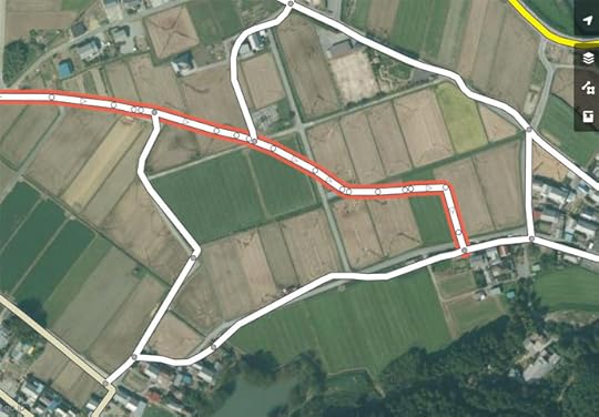
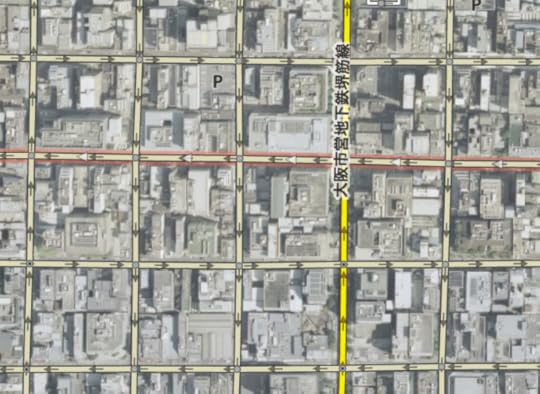
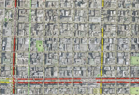
Map Data of Suspect Quality
This is the view in the
default OpenStreetMap map editor, with the mapped roads presented over
some satellite imagery. It's clear from the imagery that some roads have
not been mapped, some have not been mapped well, and some non-existent
roads have been added (such as the one shown with a red border in the
screenshot above).
You have to be a bit careful about blindly trusting the satellite images, since they can be old
or misaligned, but if you trust them, you can just go ahead and start fixing the map to match the imagery. The editor is pretty easy to use once you get the hang of it.
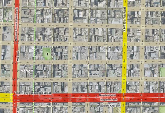
Being a geek, I go a step further than trusting the satellite images. I use road data from
the Japanese government, via its
Geospatial Information Authority of Japan web site, to build something I can
overlay within the OpenStreetMap editor to show me the surveyed location of roads:
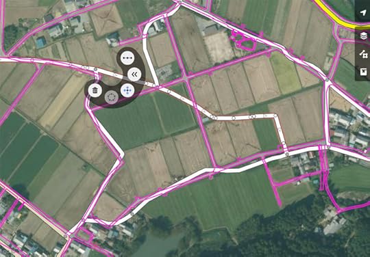
With Reference Data
The data from the Japanese government can also be suspect (old, misaligned, or for proposed roads
that don't yet exist), but it's a good sign when this data matches the satellite photo perfectly.
So, I start fixing things...
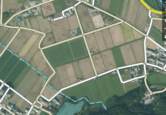
Fixed Result
It takes only a moment to fix the little area seen in the screenshots
above, but it's sort of addicting. You're fixing a road that connects to
another road that's just as bad, so you start correcting it, and so on.
Luckily, Japan is an island nation, so in theory there's a limit to how far
it can take me. I tend to get caught in a “just one more fix” loop until I
can force myself to stop and leave areas of the map untouched and
incorrect. This is difficult for a data geek like me to do.
Here's another example showing poorly-mapped roads not far from the spot above:
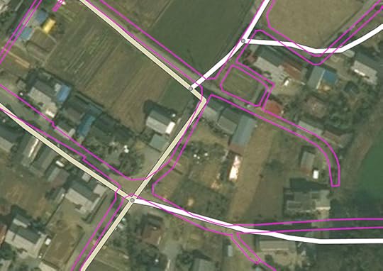
Before, but with my road-edge overlay
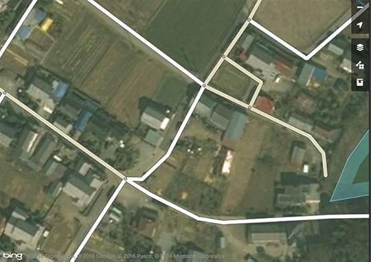
Better, but the roads seem to be shifted down and to the right a bit
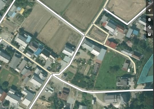
Ah, that's better
span.b696 { padding: 6px; border: gray 1px solid }
Before
- Middle
- After
mouseover a button to see that image
The difference between “Middle” and “After” is not that the road mapping was
moved, but that within the map editor, I switched to a different satellite-imagery layer.
There are various layers, and the quality of each varies considerably as you move around. In this case, the first's images were offset to the southeast by about the width of a road,
and the second's images weren't. (It could be that neither are correct, but in this case
I could compare with the government survey data, and so knew the second one to be correct.)
In writing this post, I realized that I used the wrong set of images to
roughly place the lake that pokes in from the right side of the frame... in
the “After” view, the lake is in the wrong spot. I've since returned to fix
it.
So, after saving a set of updates, it can take some time for the new data to percolate to all the places that use it...
p.h2762 { font-size: 120%; margin-top:50px }
Update Speed to Web-based Maps
Web sites that use OpenStreetMap data can see updates almost immediately... within a minute. Strava seems to have
a slightly longer delay, likely due to intermediate caching in their backend, so updates might take five or ten minutes to appear there.
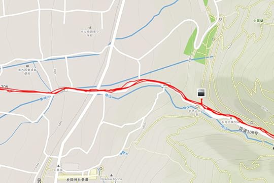
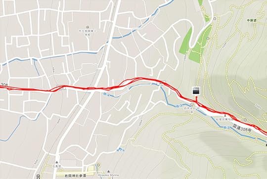
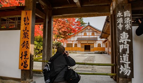
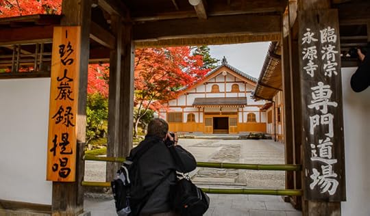
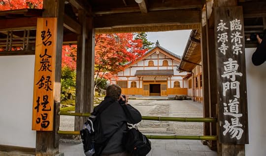
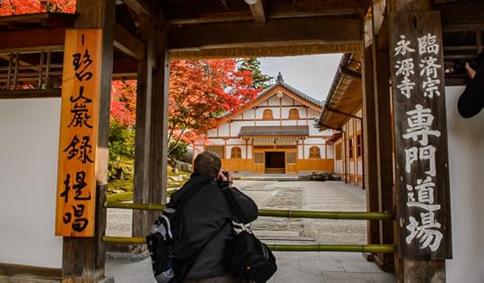
Here is another before/after pair of screenshots from Strava, showing tiny part of
this epic ride two weeks ago, descending into Osaka
on an exceedingly-steep mountain road used by a lot of tourists on foot. It turned out that the OpenStreetMap
coverage here was pretty sparse, and I thought to update it because folks on foot would likely appreciate
accurate maps when deciding where to trudge up and down.
span.b778 { padding: 6px; border: gray 1px solid }
Before
- After
mouseover a button to see that image
I updated quite a bit of the surrounding area, but
scrolling a bit farther away and you
can see sparse areas still in need of some mapping TLC.
Update Speed to Route Building
Other uses of OpenStreetMap data take longer to update. For example,
GraphHopper, where I make cycling routes, refreshes their routing data
only every few days. The maps update visually right away, but the routes they generate won't reflect updates
for up to a few days.
I don't know the update schedule for Strava's route builder, but it doesn't seem to be very often.
Changes I made two weeks ago are still not reflected in its routes.
Update Speed for Garmin GPS Units
Garmin apparently sells detailed maps for various areas of the world,
but I have no experience with these. Rather, on my Garmin 820 cycling
computer I use maps derived from OpenStreetMap data, packaged for
English-language Garmin devices by a guy in Osaka. Because these devices
can't display Japanese natively, his preparation process converts Japanese
text to “English” (to romaji). It's quite convenient.
He makes a new version available about twice a month, each time bringing
in the accumulated updates. The web page is all in Japanese,
but downloading and installing is simple.
In about the middle of the web page is a grid with a purple background...

The top pair of items are the latest data, the one marked in green is a version that includes
contour lines, the one marked in red does not. I use the latter, but a hiker probably wants the former.
Each download zip holds two “*.img” files (“gmapsupp.img” and “gmapsupp_search.img”).
After unzipping, just copy the two “*.img” files into your Garmin unit's “Garmin” folder. That's all there is to installing these maps and their updates.
Update Speed for Offline-Map Apps
The two phone apps I mentioned earlier are very convenient because after an initial map download,
they don't need an internet connection to work, so you can use them when you're deep in the mountains
with no coverage. Both are available on both iOS and Android.
In the case of Galileo Offline Maps, the map for all of Japan currently
takes about 470 megabytes of storage. With Maps.me, you can load maps by
the prefecture level (e.g. state/province). Kyoto Prefecture currently takes
47 megabytes (though the app inexplicably includes “Kyoto Prefecture” under
the “Shikoku” region, despite my having reported this bug to them a year
ago).
Updates that you (and I and others) make to OpenStreetMap data won't get
into these apps very quickly, though. They tend to refresh their maps only
once every month or three.
Each app has its strengths. You can record your track with Galileo Offline Maps,
while Maps.me lets you do turn-by-turn routing (and you can route while offline, too).
Hidden Map Features: One Way(ish) Streets
I've been making updates to OpenStreetMap data like this for a year, and have spent way, way too much
time on it. I guess it's my way of trying to give back a bit for all the wonderful stuff I am freely allowed to use.
However, there was one part of the updates that was particularly frustrating.
At first the problem may not be apparent...
Lurking Problem
lots of one-way streets.... sort of
To understand the problem, let's look at a typical “one way” street sign in Japan:
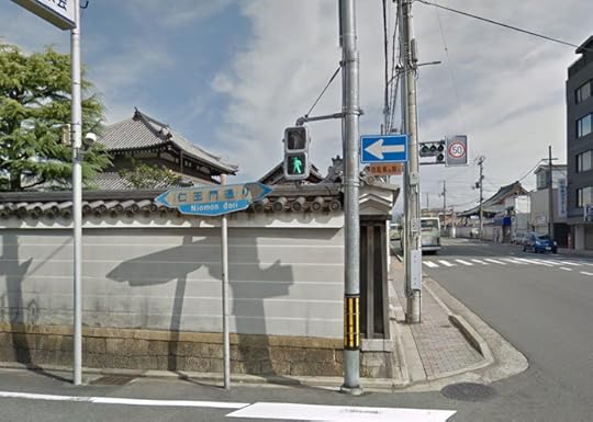
Typical “One Way” Sign
The devil is in the details.... the vast vast majority of “one way” signs in Japan are paired
with another sign:
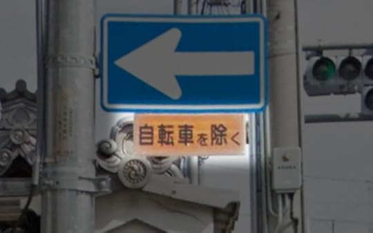
“Except Bicycles”
自転車を除く
Bicycles are allowed to go either direction on such streets, which is, as
I said, most one-way streets in Japan. It's quite convenient for cyclists.
I would guess that the little “Except Bicycles” sign is the most common
street sign in Japan, since it's added to almost all of the “one way” and
“do not enter” signs.
So why do we care about this when mapping? If left as is, automatic
routing (such as via the Maps.me phone app or the GraphHopper and
Strava web sites) won't utilize these hybrid one-way roads to their fullest
extent when routing for bicycles, yielding results that are more
inconvenient than they should be, but in the worst case completely
disallowing routing through an area that should be allowed.
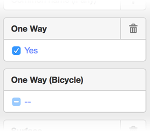
So, the OpenStreetMap editor does have a way to mark such streets as “not one way for bicycles”, but it's not convenient:
Select the street segment
In the left sidebar, scroll down to the “All tags” list. Each
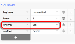
street will have its own mix of tags, but if it displays as a one-way street, it'll have a “oneway” tag with
a value of “yes” (or in some
cases, “-1” or
“1” or “true”, which all
mean the same as “yes” for our purposes).
As illustrations, here are the tag lists from two random one-way
streets:
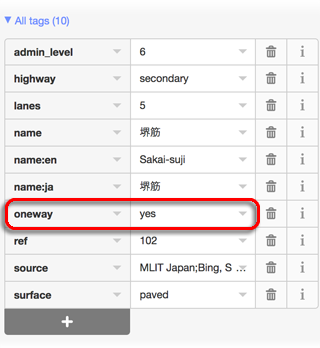
Add a “oneway:bicycle” tag with a “no” value...
1) Click the add-tag “+”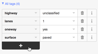
2) Add field “oneway:bicycle”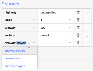
3) Make its value “no”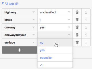
4) Voilà, it's now a one-way road for all but bicycles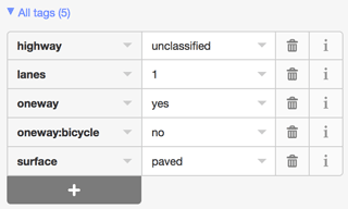
One has to be careful to make sure the updates are appropriate. Sometimes very large streets are encoded with
separate “roads” for each direction of travel, and each such “road” is one way in its direction for bicycles as well. If these are given a “oneway:bicycle” tag, the value should be “yes”.
It's very nice that “one way for all but bicycles” is possible, but how it's done is really inconvenient,
both because of all the steps one must go through to add the notation, and because there's no way to know whether
a one-way road has been so notated without scanning all the tags for “oneway:bicycle”.
So, when you look at something like this...
Sea of One-Way Streets
that may or may not have been updated for bicycles
... you don't know to what extent, if any, the one-way streets have been updated for bicycles.
Even if you have the patience of a saint and check/update them all, will you remember the exact extent
of your work after a week or a month, or will you have to spot check for “oneway:bicycle” to remind yourself
that you've already done this area? But in either case, how do you know you got them all?
I was in the midst of this frustration yesterday when I tickled myself pink
by coming up with a solution:
“Fat” Streets Need to be Updated
I made it so that streets I need to address stand out visually.
To do this, I downloaded the source code to the OpenStreetMap map editor and made a few changes so that
non-highway streets that are noted “oneway”, but that have no “oneway:bicycle” notation of any kind, are displayed
with exaggerated thickness.
If it's truly one way even for bicycles, I add
“oneway:bicycle” with a value of “yes”. This doesn't
have an effect on routing, but it denotes to anyone inspecting the tags
that the bicycle aspect has been addressed.
But for the typical one-way street, I add “oneway:bicycle” with
a value of “no”.
And to make it easier to apply a “oneway:bicycle” tag, I updated the UI so that it's a simple checkbox
that cycles among “no tag”, “no”, and “yes”.
And to make it even easier, I made a keyboard shortcut to cycle through the tag values,
so I just click a street, tap the key, click the next street and tap the key again, etc.
Once all the “fat” streets are gone, I'm done with an area. Easy peasy! It takes about 15~20 seconds to
take care of an area the size seen in the screenshot above.
I've taken care of most of Kyoto, and much of Osaka, but it's still a slow process to do a large area because I have to pan
around looking for “fat” streets. If I zoom out too far, the tool exits editing mode and I can't see anything, so I have to
be zoomed up, and just pan around.
Anyway, I'm tickeled that I could update the map editor. It's not the kind of programming I'm good at,
and that they can build this kind of thing in a browser just boggles my mind. It garners appreciation
that there are people out there much smarter than I, and that they donate their talents so freely.
December 25, 2016
Jolly Hat
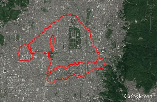
Hat
the path of today's bicycle ride through Kyoto
After long rides on Wednesday and
Thursday, and a very hard workout
at the gym on Friday, my legs have been extremely sore, so today I went on an easy “recovery ride”
in the city, just to get my muscles moving a bit.
It was nice... I go the “KOM” (best registered
time) on the highly-sought-after “Jolly Hat” segment.
Doing an image
search for “Strava art” yields many impressive results. Some are sort
of “fake”, like
this famous
“cyclist”
drawing and this
famous “bear”
drawing, but many are real and amazing. (I
put “fake” in quotes because they are indeed “art” created via
“Strava”, but
the route you see as a picture is not the path the cyclist actually rode;
some parts are created out of thin air with digital trickery, making the result
substantially less impressive in my eyes.)
I've been wanting to do one myself, and have vaguely envisioned
something impressive, but ran into the slight problem of having absolutely
no artistic skill (except with a camera, which doesn't help me here). So over time I kept lowering my sights, and finally got it low enough to make
it a reality, copying a simple line drawing of a jolly hat. Even this meager
creation taxed my artistic “talents” to their limit. Being a Sunday morning,
traffic wasn't too bad; it took about 2½ hours to ride the 35km (22mi)
of stop-and-go city streets.
We didn't have the energy to do Christmas Cards this year, so perhaps we'll consdier this it. /-:
December 16, 2016
Reports of My Demise Have Been Greatly Exaggerated
Nikon D4 + Nikkor 24-70mm f/2.8 @ 24mm — 1/400 sec, f/6.3, ISO 6400 —
map & image data — nearby photos
A Beautiful, Peacful Place
where I've been trying to imagine myself lately
( a deserted road near this place )
So, my web site was down for a few days. Sorry about that.
It doesn't happen often, but this time was a doozy. The ISP hosting my
server went bankrupt, and by the time I found out, my server was sitting
dead on the floor of a warehouse.
Nikon D4 + Voigtländer 125mm f/2.5 — 1/25 sec, f/2.5, ISO 6400 —
map & image data — nearby photos
How I've Felt Lately
another of the wisdom kings at the Ushio Kannon Temple (牛尾観音)
I've got to say, though, I'm actually very thankful.
My web hosting has always been free, a kind, ongoing gift from a former coworker
at Yahoo!. Even though we haven't talked for a decade, he's let my
server sit in his business and occasionally burn up some of his support
staff's time. I've never had to pay for bandwidth, or even think about
bandwidth. For perhaps 15 years. I'm so very thankful.
I'm thankful that my brother Steve
dropped everything to help me set up an empty
virtual server at Amazon Web
Services, where in this situation “help
me” is used euphemistically to mean “did everything”.
I looked into it as a
backup a year ago, and the configuration
was just too daunting for me to comprehend.
I'm thankful that I had a backup of my system, and that it was up to
date. Crashplan doesn't officially
support headless clients like I'd need on a
remote server, but they tell how to do it and it works, and works
well. I was able to restore 50+GB of stuff in
about an hour. It seems that both Crashplan and
Amazon have fast pipes.
Nikon D4 + Voigtländer 125mm f/2.5 — 1/400 sec, f/5.6, ISO 5600 —
map & image data — nearby photos
My Cup Runnith Over
( please ignore that “my cup tippith over” is probably a more-appropriate caption for this photo )
After setting up my work environment on the new system, and restoring
the bulk of things from backup, I then had to set
everything up. This is a bit like collecting
stuff from a tornado-ravaged house to set up shop
at an empty cabin across the street. I had to
relearn how to do all the system-administration tasks, moving as I did from Debian to Amazon. Amazon's yum
package management system seems easy enough to work with ("YUM" stands for
"Yet Uh-nutha' Manager"), and is nicely populated with packages, though it
took me a while to figure out “yum list installed”.
I had to re-figure out how to configure the main pieces of my server
solution (Apache, MySQL, wordpress) and get them to work together. After
doing that, I had to do it all over when I had to bite the bullet and grade
major versions.
After that it was checking things and correcting the bazillion little
things that needed to be re-installed from somewhere, reconfigured, or
retwiddled. I'm sure as many more wait to be discovered.
Nikon D4 + Voigtländer 125mm f/2.5 — 1/400 sec, f/2.5, ISO 1800 —
map & image data — nearby photos
Loose Ends
I'm sure there will be many
( at the Daichiji Temple (大池寺), Shiga Japan )
The worst part of the whole thing has been having to deal with email via
a web page. I've used emacs to read email for
over 30 years, and I'm used to it, but with my machine crashed, I had to revert to interfacing via a
web page. Ugh.
In the end I think I've got almost everything back to normal, and in hindsight
I'm amazed at how smoothly, relatively speaking, it all went.
One casualty of the move is my (now disabled) Online
Image Metadata Viwer. It got a fantastic number of accesses each day,
but most were scrapers using it, it seems, to try to access other sites
anonymously. I went to great lengths to try to shut this kind of use down,
but enough gets through that I just can't risk the bandwidth, now that I'm
going to have to pay. I have no idea what kind of bandwidth I used to use,
nor how much that would cost now. I guess I'll find out soon enough.
iPhone 6+ — 1/1800 sec, f/2.2, ISO 32 —
map & image data — nearby photos
Potato Boy
because potatos
December 11, 2016
Meeting my Match on a Long Iga-Nara-Osaka Cycling Adventure
I had quite the little cycling adventure yesterday, venturing into some areas I'd never been, and facing the most
heinously-steep road I'd ever seen. The total distance was 191km (118mi), making it my 7th-longest ride
ever. This blog post, mostly as a diary for myself, is almost as long.
The distance was no problem, but as it seems with many of my longer rides, lack of time management does me in and I have to kill myself to get back in time for something (in this case Saturday-evening Mass).
The outline of this ride was simple... head down to Iga City, a place I'd never been, because, well, I'd never been there. Then
cut across to Nara (which I'd cycled to once, last month), then from there
across to Osaka Castle.
By the time I got to Osaka Castle I would have had 140km (87mi) of mountainous riding, but then the return home would be all
flat, mostly along nice cycling paths. I've blogged about that 51km (32mi) Osaka-Castle ride a few times, here, here, and here. I thought that even if the ride thus far had tired me out,
the flat return taken at my leisure would be no problem. Sigh, if I could only plan better.
Anyway, I knew it would be a long day, so I planned to take it slow and steady.
Cycliq Fly12 —
map & image data — nearby photos
Hitching a Ride
relaxing at 47kph (29mph) on National Route 1
8:00am
I felt a bit cheap as I blew past the cyclist seen in the photo above (a screenshot from my bike's
front video camera) as I was drafting the truck. I was far enough back that
I could easily react safely to anything the truck did, but close enough that the draft effect was
huge. Even at 40~50kph, I kept having to use my brakes to maintain the safety buffer.
The big danger to drafting a truck like this is a danger shared by motorcycles: traffic can't see you behind the truck as you
approach them, so someone in a rush wanting to pull across your lane the moment the truck passes could
hit you. This wasn't a concern this morning because it was rush hour, and there was an SUV right behind me the whole time. (Maybe it was drafting me! 
December 5, 2016
A Deeply-Red “Wisdom King” at the Ushio Kannon Temple
Nikon D4 + Voigtländer 125mm f/2.5 — 1/200 sec, f/2.5, ISO 6400 —
map & image data — nearby photos
“Ragaraja”
Ushio Kannon Temple (牛尾観音), Kyoto Japan
I made another visit to the hard-to-reach Ushio Kannon Temple, which I wrote about a couple of months ago, but this time I
went by car and took my nice camera. The beautiful, rich matte red of this dimly-lit statue caught my eye...
Nikon D4 + Nikkor 24mm f/1.4 — 1/100 sec, f/2, ISO 3200 —
map & image data — nearby photos
愛染明王
I don't know anything about Buddhism, but this statue is apparently of a
Wisdom King named “Ragaraja”, a “dharmapala deity” that is “known to transform
worldly lust into spiritual awakening”, according to Wikipedia.
Visually it's quite interesting, and was one of many in a small, dimly-lit hall.
To be continued...
November 29, 2016
Benefits of Cycling #27: Freeing Yourself from the Coffin of Electronics Our Modern Lives Have Become
Nikon D4 + Nikkor 70-200mm f/2.8 @ 70mm — 1/320 sec, f/6.3, ISO 320 —
map & image data — nearby photos
The Wide Open Road Awaits
near Onyu Pass (おにゅう峠)north of Kyoto, Japan
Ah, the wide open road, one of the great benefits of cycling, getting away from the stress of the city and immersing oneself in
nature, freeing oneself, at least temporarily, from the coffin of electronics that our modern lives have become.
Cycling lets you leave the electronic shackles behind, and connect with nature and friends.
Nikon D4 + Nikkor 24-70mm f/2.8 @ 24mm — 1/250 sec, f/6.3, ISO 100 —
map & image data — nearby photos
Whether Cycling Alone...
at Mt. Norikura (乗鞍岳)
(Japan's highest paved road)
Panasonic LX100 at an effective 41mm — 1/200 sec, f/3.5, ISO 640 —
map & image data — nearby photos
.. Or with a Friend...
Panasonic LX100 at an effective 24mm — 1/125 sec, f/5.6, ISO 250 —
map & image data — nearby photos
... or Two
iPhone 6+ — 1/125 sec, f/2.2, ISO 32 —
map & image data — nearby photos
... or Three
iPhone 6+ + front camera — 1/120 sec, f/2.2, ISO 40 —
map & image data — nearby photos
... or 100
Don't get me wrong.... hiking can be great, as can motorcycling. Both get you away from the rat race, but
cycling seems to hit the sweet spot. You can see a larger variety of different scenery than you can on foot,
yet you're still “raw” with nature, unlike when on a motorcycle.
But the biggest benefit may be in freeing your mind from all the modern hassles, leaving all the electronics behind.
Well, except a light... you should have an electronic light.
Nikon D4 + Voigtländer 125mm f/2.5 — 1/125 sec, f/2.5, ISO 6400 —
image data
One Bit of Electronics Not to Ditch
for safety, to be seen
Nikon D4 + Voigtländer 125mm f/2.5 — 1/320 sec, f/4, ISO 5000 —
image data
Okay, One More
arguably more important than the first
I'm pretty anal about safety, so I run with lights on the front and back at all times, even during the middle of the day. So, I do have to make sure that their internal batteries are charged before every ride.
Actually, in my case, my bike's shifters are electronics, so I need to make sure they're charged as well.
Nikon D4 + Voigtländer 125mm f/2.5 — 1/320 sec, f/2.5, ISO 5600 —
image data
Shimano Di2 Front Derailleur
Nikon D4 + Voigtländer 125mm f/2.5 — 1/320 sec, f/2.5, ISO 5000 —
image data
Shimano Di2 Rear Derailleur
It's not fun when the derailleurs run out of battery, as I
found out on a 225km ride last month. The entire Di2 system is
charged via a control box under the handlebar stem:
Nikon D4 + Voigtländer 125mm f/2.5 — 1/320 sec, f/2.5, ISO 2200 —
image data
Shimano Di2 Control Box
and the SM-EWW01 wireless unit piggybacking below
The problem when the battery ran out, I realize now, was that the wireless unit takes a lot more battery than the unit
itself. Without the wireless unit, the battery lasts for months, but with it, weeks. I'd added it just prior to that long ride,
and hadn't yet realized just what an electronic toll it takes. So now I make sure to charge its battery much more often.
The wireless unit transmits the current status of the derailleurs to my cycling computer, which I guess is another bit of
electronics I rely on...
Nikon D4 + Voigtländer 125mm f/2.5 — 1/320 sec, f/2.5, ISO 2800 —
image data
Garmin Edge 820
cycling computer
Now that I think about it, I do need to bring my phone with me just in case...
Nikon D4 + Voigtländer 125mm f/2.5 — 1/320 sec, f/2.5, ISO 2800 —
image data
Pretty Much Required
for communication and mapping in case of troubles
... and going along with that, so I can be alerted to messages and such...
Nikon D4 + Voigtländer 125mm f/2.5 — 1/320 sec, f/2.5, ISO 800 —
image data
Apple Watch
vibrates on the wrist so I can be alerted even if I can't hear
Nikon D4 + Voigtländer 125mm f/2.5 — 1/320 sec, f/2.5, ISO 800 —
image data
Sunglasses Need a Good Charge
or they wouldn't be very good as sunglasses, would they?
I need to write up a post on these sunglasses (CTRL One), which can instantly convert between tinted and
mostly-clear, at the touch of a button. I find them very useful because I can maintain eye protection (from bugs,
raindrops, etc.) even when plummeting down a mountain in dark forest shade.
Nikon D4 + Voigtländer 125mm f/2.5 — 1/320 sec, f/2.5, ISO 900 —
image data
I Usually Bring a Camera
either this Panasonic LX100 or a Nikon D4
And while we're on the subject of cameras, as both a kind of “insurance” and just to have the cool footage, I like to have cycling cameras on both the front and back...
Nikon D4 + Voigtländer 125mm f/2.5 — 1/320 sec, f/2.5, ISO 1800 —
image data
Rear Camera
Cycliq Fly6
Nikon D4 + Voigtländer 125mm f/2.5 — 1/320 sec, f/2.5, ISO 1800 —
image data
Front Camera
Cycliq Fly12
These Cycliq products are poorly thought out, poorly designed, and poorly supported, but they more or less work and don't have
any competition in this product space, so I guess it's the best I can do.
In the photo above the camera and cycling computer are attached to the bike with a K-Edge mount that I wrote about recently, about how it broke under stress and
how K-Edge came through. Since writing that post, another copy of the same mount failed in the same way. I wrote back to the
company, but haven't heard anything for more than a week. Sadly, I guess the trust the mount had regained is lost. I'm no longer
using it.
And to continue with speaking of disappointing products, I currently use two products by Wahoo, but
they're both pretty bad.
Nikon D4 + Voigtländer 125mm f/2.5 — 1/250 sec, f/4, ISO 6400 —
image data
Wahoo Speed-and-Cadence Sensor
horribly designed; already broken
The Wahoo “Blue SC” speed and cadence sensor seems like a great product at first. It's both ANT+ and Bluetooth,
which is super convenient. It's the only one I know of that can talk to both my iPhone and my cycling computer
at the same time. But it's got the most moronic design.
It attaches to the bike with a big rubber band. The band hooks to one side of the unit more or less
permanently, is stretched around part of the bike (the non-drive-side chainstay), then hooks back onto the unit on the other side.
This is a common way of attaching stuff to a bike, but the way Wahoo
implemented it is fantastically bad because they put the “hook” side
facing in, so you really can't get at it without taking the wheel off, and even then it helps to have small hands. Then, to make
matters worse — much worse — the “more or less permanently” attach point is anything but... the band barely fits into the tiny shallow notch, and immediately pops
out the moment you put any strain on the band (such as when trying to attach it to the bike), unless the planets are aligned
just so.
If you are able to get it to stay as you stretch the band, you've then got to figure out how to get the band to the
rear of the unit, something that would perhaps be easy in the best of conditions (inside a workshop with the bike mounted
and the wheel off), but it's the mother of all frustration out on the road. I would never try to work with this unit
within earshot of my parents or child.
Luckily my parents and child don't often ride with me, because one needs to deal with this piece of crap out on the road from
time to time because the band has a habit of just popping off for no apparent reason. I ended up adding twist ties as backup attachment, just to keep it from getting lost, and this has saved it
a number of times. But even with the band and the twist ties, it's still a hot mess... it has to be positioned within fairly tight tolerances, but the poor mount deign makes it easy
for it to slip out of alignment. I even used some Dycem (amaaaazing stuff) to keep it from
slipping, and it helps, but Wahoo's bad design trumps all.
I truly can't believe that they actually tested this design in the field, using real human cyclists.
It's an unfathomably-bad design. It's a gratuitously-, wantonly-bad design.
But that's okay, I won't be using it much longer. The speed sensor has recently stopped working for
no apparent reason. I can hear the leaf switch close when I bring the magnet
near, but the data never makes it out of the unit. It's a piece of crap.
And along the same lines, the Wahoo heart-rate sensor is also poorly designed.
Nikon D4 + Voigtländer 125mm f/2.5 — 1/320 sec, f/2.5, ISO 3200 —
image data
Wahoo TICKR X
heart-rate sensor
Plastic has broken off both ends of the strap, in a way that seems to be inevitable given its stupid design. So far it's still working as a heart-rate sensor, but given that Wahoo apparently has no problem selling stuff
whose basic design is so very bad, I don't think I'll ever buy one of their products again.
At least I don't have to recharge these two Wahoo products before each ride... they work off small batteries that
last about a year.
I'm an ultra data geek, so I don't want to lose the data for my ride if my
cycling computer has “issues”. So, I also
record my rides on my phone using the most-excellent Galileo Offline Maps app. (The
app is great, though Apple dorks activity tracking on their phones.)
As a further backup, I also record my rides with a separate stand-alone GPS/GLONASS unit:
Nikon D4 + Voigtländer 125mm f/2.5 — 1/125 sec, f/8, ISO 6400 —
image data
Bad Elf GPS PRO+
it's not very accurate, but better than no backup
And finally, with all these things with batteries that can run down, on long rides they can need a
boost, so I often bring along a spare battery:
Nikon D4 + Voigtländer 125mm f/2.5 — 1/320 sec, f/8, ISO 4000 —
image data
Extra Battery
to top off my phone, cycling computer, lights, cameras, etc.
I used to have a power meter, which also needed to be recharged, but it was so inaccurate that I returned it,
so at least I have that going for me.
Okay, so other than all that stuff, cycling frees you.
Of course, you have to be able to recharge it all, so you also need a basket full of chargers and
cables. Here's the floor of my hotel room during my Norikura trip earlier in
the year...
Nikon D4 + Nikkor 24-70mm f/2.8 @ 24mm — 1/30 sec, f/2.8, ISO 6400 —
map & image data — nearby photos
Home Sweet Home
for an electronic rat
Panasonic LX100 at an effective 33mm — 1/200 sec, f/5.6, ISO 200 —
map & image data — nearby photos
Cycling at its Best
nature... friends... I guess you don't even need a bike!
iPhone 6+ — 1/750 sec, f/2.2, ISO 32 —
map & image data — nearby photos
The Wide Open Road Calls
just be sure your battery is charged, or it'll go to voicemail
November 28, 2016
Rear Courtyard at the Eigenji Temple
Note: this article may not appear properly in news readers.
This article contains interactive aspects that are likely removed by most news readers. Please see this particular article directly on Jeffrey's blog for full functionality.
Nikon D4 + Voigtländer 125mm f/2.5 — 1/400 sec, f/2.5, ISO 125 —
map & image data — nearby photos
Roof Detail
Desktop-Background Versions
1280×800 · 1680×1050 · 1920×1200 · 2560×1600 · 2880×1800
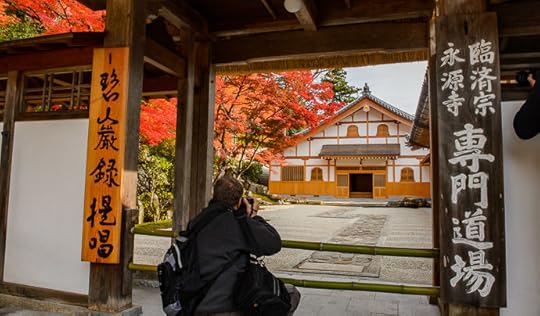
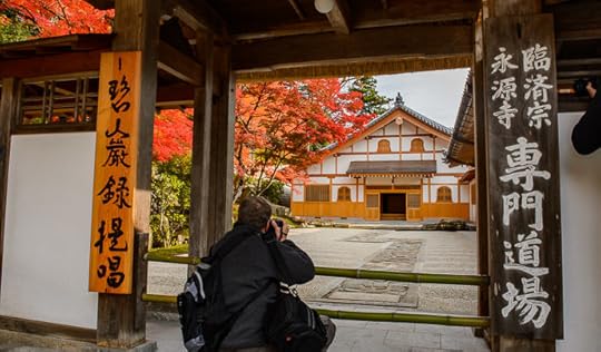
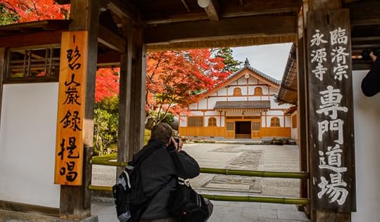
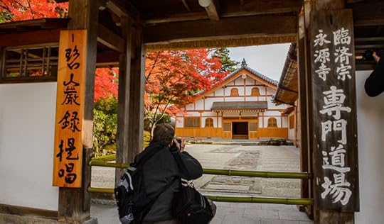
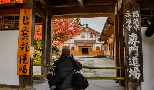
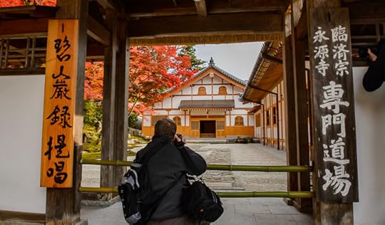
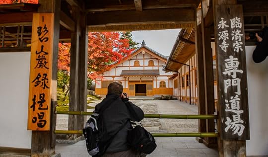
Continuing on from
“The Back Entrance to Shiga’s Eigenji Temple”
the other day, about a trip last week to the Eigenji Temple (永源寺) about an hour's drive from Kyoto,
after entering via the rear gate, you find a closed-off courtyard to one side...
Nikon D4 + Nikkor 24-70mm f/2.8 @ 24mm — 1/400 sec, f/7.1, ISO 500 —
map & image data — nearby photos
Rearmost Courtyard
Eigenji Temple (永源寺), Shiga Japan
You're not allowed inside, but it's still pretty from the gate.
Nikon D4 + Nikkor 24mm f/1.4 — 1/400 sec, f/9, ISO 1000 —
map & image data — nearby photos
To give a better sense of the space, here's a wigglegram:
div#di4v4JjFAjFAgcA img { width:690px; height:404px; visibility:hidden; position:absolute; top:0; left:0; border: solid 10px #311}
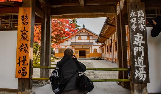
Animatable Wigglegram (15 frames) — slowly sweep mouse from side to side to view 3D effect
写真の上をマウスで左右にゆっくり動かすと「3D」な感じが出ます。
=i.length)return 0;else return which;}else{if(which=i.length)return i.length-1;else return which}};t=function(event){if(m>0&&((new Date().getTime())-m)R&&s0){f(c(s-1));console.log(s+":delta is "+delta);L=0.05;R=0.2;T=tilt;}}};d.ontouchmove=d.onmousemove=function(e){if(e.touches&&e.touches.length>1)return true;var x=Math.floor((e.clientX||e.pageX)/BW);var which=c(x>l?s+(x-l):s-(l-x));l=x;if(which!=s){m=new Date().getTime();f(which);}return false;};window.addEventListener('devicemotion',t,false)}
Nikon D4 + Voigtländer 125mm f/2.5 — 1/400 sec, f/4, ISO 180 —
map & image data — nearby photos
More Roof Detail
To be continued...
November 25, 2016
Victoria Bampton’s Lightroom-Misunderstandings Article
Nikon D4 + Nikkor 24-70mm f/2.8 @ 24mm — 1.3 sec, f/11, ISO 2500 —
map & image data — nearby photos
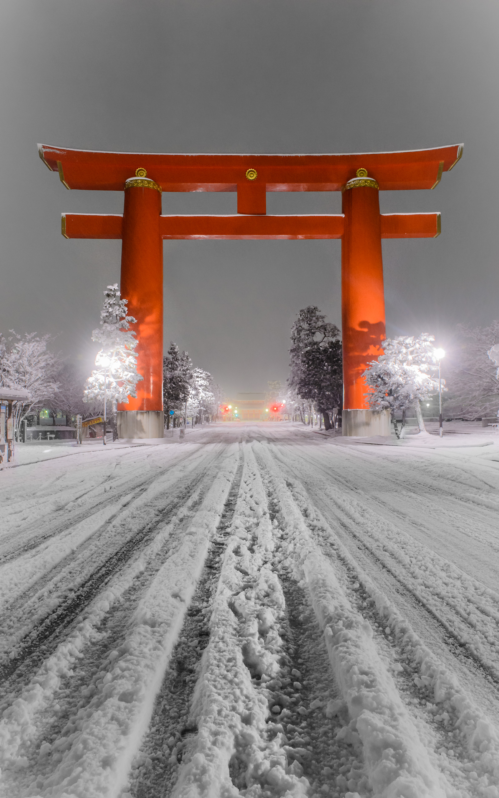
Main Gate of the Heian Shrine
after a snow, Jan 3 2015
平安神宮鳥居、去年の一月三日
Vertical Desktop-Background Versions
1050×1680 · 1200×1920 · 1600×2560
This picture is from the same snowy outing almost two years ago that produced
the three-part “Kyoto At Night During a Heavy Snow” posts
(part 1 ·
part 2 ·
part 3). This shot mimics the one that leads Part 2,
but this one was taken five hours later (at 4:42am) after the snow had long stopped falling.
Anyway, it's just a random photo to accompany a recommendation for users of Adobe Lightroom to read
Victoria Bampton's “Lightroom Catalogs – Top 10
Misunderstandings” article. New users may find some misconceptions
cleared up, while veterans will find a good resource to point to when helping others.
Victoria (“The Lightroom Queen”) has a
thorough, non-technical writing style that's easily digested by the non-geek photographer. Her “Lightroom Missing
FAQ” is well worth it if you're struggling with Lightroom, especially workflow-related issues.
As a professional courtesy she gave me a copy of it back in the Lightroom 5 era (the current version of course covers Lightroom 6/CC), and that
version is
a ridiculous 624 pages long. I tend to prefer printed books to ebooks, but
this really benefits from being a searchable PDF. Highly recommended.
Jeffrey E.F. Friedl's Blog

- Jeffrey E.F. Friedl's profile
- 14 followers

