Shane K. Bernard's Blog, page 4
June 5, 2016
Welcome to Bayou Teche Dispatches. . . .
Bayou Teche Dispatches is a collection of my writings about south Louisiana history and culture. Often it consists of material I could not use in my books for one reason or another, but which I nonetheless found fascinating. I hope you enjoy reading these articles as much as I enjoyed researching and writing them.
If you publish information from them, however, please remember to cite this blog as your source and, if applicable, to supply a return link. Please do not repost articles in their entireties, but short block quotations that fall within range of "fair usage" are acceptable.~ Shane K. Bernard
Table of Contents
❧ Now Available: My New Book about Bayou Teche
A narrative history of Bayou Teche and journal of canoeing the present-day bayou
❧ A Railroad History of Avery Island
An article I wrote for someone else's blog in 2010
❧ Sur le Teche: Exploring the Bayou by Canoe, Stage 1
Port Barre to Arnaudville
❧ Rough Rider Redux: A Photo of Theodore Roosevelt in Downtown New Iberia?
A forgotten photo of Theodore Roosevelt in Cajun Country
❧ A Fiction Interlude: My Short Story "The Phrenologist"
A short story about racism set in antebellum New Orleans
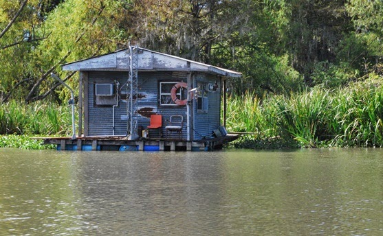
❧ A Floating Dancehall on the Teche: The Club Sho Boat
A riverboat that became a nightclub and restaurant
❧ A Meteor over Cajun Louisiana: Window on Atomic-Age Anxieties
Confusing a meteor for an atomic bomb
❧ A Film Documents South Louisiana's Logging Industry, ca. 1925: Responsible Stewardship or Environmental Disaster?
Digitized film about cypress logging along the Teche
❧ A Glimpse from 1968: Historic Films Looked at Cajuns and Creoles in Epic Year
Digitized French films capture an important year in south Louisiana history
❧ Now Available: My Children's History of the Cajuns in English and French Editions
Buy my Cajun book for kids so I can pay off my credit card
❧ "Cajuns of the Teche": Bad History, Wartime Propaganda, or Both?
A 1942 film with excellent images, horrible script,
❧ A Snake, a Worm, and a Dead End: In Search of the Meaning of "Teche"
Searching for the meaning of the word "Teche"
❧ Galaxies, Bowling and Swamp Pop: Johnny Preston and The Cajuns in Escondido
Examining a Cajun reference in a chain e-mail about old gas stations
❧ Serendipity and Fort Tombecbe: Cooperation between Historians and Archaeologists
Accidentally finding a map of a fort coincidentally excavated by my friend
❧ Notes on Two Nineteenth-Century Engravings of South Louisiana Scenes
Vintage magazine images of Cajun and Creole women
❧ Finding History Right around the Corner: Heroism on the Cajun Home Front
A nearly forgotten World War II landmark a block from my residence
❧ My Father's Childhood Autograph Book on the History Channel?
When Dad met Hank Williams, Sr.
❧ My Oddball Collection of Cajun Warplane Photos
Cajun-themed combat aircraft
❧ Elodie's Gift: A Family Photographic Mystery
An old tin type image given to me by a great-aunt
❧ A rocket named "the Cajun"?
❧ Perpetuation of a historical error
❧ Debunking the Alleged Origin of the Word "Coonass"
Finding a word by accident that wasn't yet supposed to exist
❧ More on That Word "Coonass": A Labor Dispute Trial Documents Its Use in 1940
The earliest known use of this controversial word
❧ "To Err Is Human": Errata from My Books
Everyone makes mistakes
❧ An Old Bull Durham Tobacco Ad in New Iberia, or Palimpsests on the Teche
This vintage advertisement has since been destroyed
❧ Remembering Polycarp: A Cajun TV Show Host for Children
Everyone loved Polycarp!
❧ From Jet Fighters to Football: Origin of the Phrase "Ragin' Cajun"
Where this catchy term originated (as far as anyone knows)
❧ The Elusive André Massé, Pioneer of the Attakapas
An almost mythical explorer of the Teche region
❧ More on the Elusive Andre Massé, Early Settler of the Attakapas District
Revelations about him in a historical document
❧ La Chute: A Waterfall on Bayou Teche?
A waterfall in largely flat south Louisiana
❧ Gumbo in 1764?
The earliest known reference to gumbo in Louisiana
❧ On That Word "Gumbo": Okra, Sassafras, and Baudry's Reports from 1802-1803
More on the history of gumbo in Louisiana
❧ La Pointe de Repos — Early Acadian Settlement Site along the Teche
Colonial-era settlement near present-day Parks, Louisiana
❧ A 1795 Journey up the Teche: Fact, Fiction, or Literary Hoax?
It almost fooled me . . . almost
❧ All the Same Place: Isla Cuarin, Côte de Coiron, Île Petite Anse, Petite Anse Island & Avery Island
Evolution of a place name in the south Louisiana coastal marsh
❧ The Grevembergs, Early Cattle Ranchers of the Attakapas
When someone accidentally transposes two numerals
❧ Tracking the Decline of Cajun French
Research behind the language stats in my book The Cajuns
❧ The Secret CODOFIL Papers
I waited how long for the FBI to release these documents?
❧ Agnus Dei Artifact Found on Banks of Bayou Teche
A religious symbol turns up in the mud at Breaux Bridge
Click here to see our Privacy Policy.
If you publish information from them, however, please remember to cite this blog as your source and, if applicable, to supply a return link. Please do not repost articles in their entireties, but short block quotations that fall within range of "fair usage" are acceptable.~ Shane K. Bernard
Table of Contents
❧ Now Available: My New Book about Bayou Teche
A narrative history of Bayou Teche and journal of canoeing the present-day bayou
❧ A Railroad History of Avery Island
An article I wrote for someone else's blog in 2010
❧ Sur le Teche: Exploring the Bayou by Canoe, Stage 1
Port Barre to Arnaudville
❧ Rough Rider Redux: A Photo of Theodore Roosevelt in Downtown New Iberia?
A forgotten photo of Theodore Roosevelt in Cajun Country
❧ A Fiction Interlude: My Short Story "The Phrenologist"
A short story about racism set in antebellum New Orleans
❧ A Floating Dancehall on the Teche: The Club Sho Boat
A riverboat that became a nightclub and restaurant
❧ A Meteor over Cajun Louisiana: Window on Atomic-Age Anxieties
Confusing a meteor for an atomic bomb
❧ A Film Documents South Louisiana's Logging Industry, ca. 1925: Responsible Stewardship or Environmental Disaster?
Digitized film about cypress logging along the Teche
❧ A Glimpse from 1968: Historic Films Looked at Cajuns and Creoles in Epic Year
Digitized French films capture an important year in south Louisiana history
❧ Now Available: My Children's History of the Cajuns in English and French Editions
Buy my Cajun book for kids so I can pay off my credit card
❧ "Cajuns of the Teche": Bad History, Wartime Propaganda, or Both?
A 1942 film with excellent images, horrible script,
❧ A Snake, a Worm, and a Dead End: In Search of the Meaning of "Teche"
Searching for the meaning of the word "Teche"
❧ Galaxies, Bowling and Swamp Pop: Johnny Preston and The Cajuns in Escondido
Examining a Cajun reference in a chain e-mail about old gas stations
❧ Serendipity and Fort Tombecbe: Cooperation between Historians and Archaeologists
Accidentally finding a map of a fort coincidentally excavated by my friend
❧ Notes on Two Nineteenth-Century Engravings of South Louisiana Scenes
Vintage magazine images of Cajun and Creole women
❧ Finding History Right around the Corner: Heroism on the Cajun Home Front
A nearly forgotten World War II landmark a block from my residence
❧ My Father's Childhood Autograph Book on the History Channel?
When Dad met Hank Williams, Sr.
❧ My Oddball Collection of Cajun Warplane Photos
Cajun-themed combat aircraft
❧ Elodie's Gift: A Family Photographic Mystery
An old tin type image given to me by a great-aunt
❧ A rocket named "the Cajun"?
❧ Perpetuation of a historical error
❧ Debunking the Alleged Origin of the Word "Coonass"
Finding a word by accident that wasn't yet supposed to exist
❧ More on That Word "Coonass": A Labor Dispute Trial Documents Its Use in 1940
The earliest known use of this controversial word
❧ "To Err Is Human": Errata from My Books
Everyone makes mistakes
❧ An Old Bull Durham Tobacco Ad in New Iberia, or Palimpsests on the Teche
This vintage advertisement has since been destroyed
❧ Remembering Polycarp: A Cajun TV Show Host for Children
Everyone loved Polycarp!
❧ From Jet Fighters to Football: Origin of the Phrase "Ragin' Cajun"
Where this catchy term originated (as far as anyone knows)
❧ The Elusive André Massé, Pioneer of the Attakapas
An almost mythical explorer of the Teche region
❧ More on the Elusive Andre Massé, Early Settler of the Attakapas District
Revelations about him in a historical document
❧ La Chute: A Waterfall on Bayou Teche?
A waterfall in largely flat south Louisiana
❧ Gumbo in 1764?
The earliest known reference to gumbo in Louisiana
❧ On That Word "Gumbo": Okra, Sassafras, and Baudry's Reports from 1802-1803
More on the history of gumbo in Louisiana
❧ La Pointe de Repos — Early Acadian Settlement Site along the Teche
Colonial-era settlement near present-day Parks, Louisiana
❧ A 1795 Journey up the Teche: Fact, Fiction, or Literary Hoax?
It almost fooled me . . . almost
❧ All the Same Place: Isla Cuarin, Côte de Coiron, Île Petite Anse, Petite Anse Island & Avery Island
Evolution of a place name in the south Louisiana coastal marsh
❧ The Grevembergs, Early Cattle Ranchers of the Attakapas
When someone accidentally transposes two numerals
❧ Tracking the Decline of Cajun French
Research behind the language stats in my book The Cajuns
❧ The Secret CODOFIL Papers
I waited how long for the FBI to release these documents?
❧ Agnus Dei Artifact Found on Banks of Bayou Teche
A religious symbol turns up in the mud at Breaux Bridge
Click here to see our Privacy Policy.


Now Available: My New Book about Bayou Teche
Teche: A History of Louisiana's Most Famous Bayou
My newest book, Teche: A History of Louisiana's Most Famous Bayou, has been released by my publisher, University Press of Mississippi. (To order the book from Amazon.com, click here. It's also available from all other booksellers, including local independent booksellers.)
 Cover art for my new book.
The painting is by noted south Louisiana
artist Melissa Bonin.
As the book's description reads:
Shane K. Bernard’s Teche examines this legendary waterway of the American Deep South. Bernard delves into the bayou’s geologic formation as a vestige of the Mississippi and Red Rivers, its prehistoric Native American occupation, and its colonial settlement by French, Spanish, and, eventually, Anglo-American pioneers. He surveys the coming of indigo, cotton, and sugar; steam-powered sugar mills and riverboats; and the brutal institution of slavery. He also examines the impact of the Civil War on the Teche, depicting the running battles up and down the bayou and the sporadic gunboat duels, when ironclads clashed in the narrow confines of the dark, sluggish river.
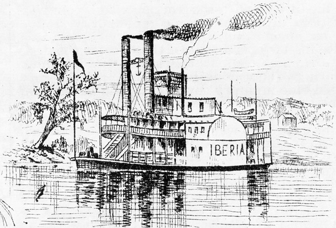 Image from the (New York) Weekly Graphic (18 April 1874).
Author's Collection.
Describing the misery of the postbellum era, Bernard reveals how epic floods, yellow fever, racial violence, and widespread poverty disrupted the lives of those who resided under the sprawling, moss-draped live oaks lining the Teche’s banks. Further, he chronicles the slow decline of the bayou, as the coming of the railroad, automobiles, and highways reduced its value as a means of travel. Finally, he considers modern efforts to redesign the Teche using dams, locks, levees, and other water-control measures. He examines the recent push to clean and revitalize the bayou after years of desecration by litter, pollutants, and invasive species. Illustrated with historic images and numerous maps, this book will be required reading for anyone seeking the colorful history of Louisiana and the Gulf Coast.
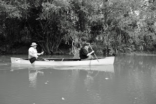
 The author (right) canoeing on Bayou Teche.
(Click to enlarge.)
As a bonus, the second part of the book describes Bernard’s own canoe journey down the Teche’s 125-mile course. This modern personal account from the field reveals the current state of the bayou and the remarkable people who still live along its banks.
Coming Soon: My New Book about Bayou Teche
In late October my fifth and newest book, Teche: A History of Louisiana's Most Famous Bayou, will be released by my publisher, University Press of Mississippi. (To preorder the book from Amazon.com, click here. It's also available for preorder from all other booksellers, including local independent booksellers.)

As the book's description reads:
Shane K. Bernard’s Teche examines this legendary waterway of the American Deep South. Bernard delves into the bayou’s geologic formation as a vestige of the Mississippi and Red Rivers, its prehistoric Native American occupation, and its colonial settlement by French, Spanish, and, eventually, Anglo-American pioneers. He surveys the coming of indigo, cotton, and sugar; steam-powered sugar mills and riverboats; and the brutal institution of slavery. He also examines the impact of the Civil War on the Teche, depicting the running battles up and down the bayou and the sporadic gunboat duels, when ironclads clashed in the narrow confines of the dark, sluggish river.
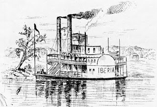 Image from the (New York) Weekly Graphic (18 April 1874).
Author's Collection.
Describing the misery of the postbellum era, Bernard reveals how epic floods, yellow fever, racial violence, and widespread poverty disrupted the lives of those who resided under the sprawling, moss-draped live oaks lining the Teche’s banks. Further, he chronicles the slow decline of the bayou, as the coming of the railroad, automobiles, and highways reduced its value as a means of travel. Finally, he considers modern efforts to redesign the Teche using dams, locks, levees, and other water-control measures. He examines the recent push to clean and revitalize the bayou after years of desecration by litter, pollutants, and invasive species. Illustrated with historic images and numerous maps, this book will be required reading for anyone seeking the colorful history of Louisiana and the Gulf Coast.
 The author (right) canoeing on Bayou Teche.
(Click to enlarge.)
As a bonus, the second part of the book describes Bernard’s own canoe journey down the Teche’s 125-mile course. This modern personal account from the field reveals the current state of the bayou and the remarkable people who still live along its banks.
As the book's description reads:
Shane K. Bernard’s Teche examines this legendary waterway of the American Deep South. Bernard delves into the bayou’s geologic formation as a vestige of the Mississippi and Red Rivers, its prehistoric Native American occupation, and its colonial settlement by French, Spanish, and, eventually, Anglo-American pioneers. He surveys the coming of indigo, cotton, and sugar; steam-powered sugar mills and riverboats; and the brutal institution of slavery. He also examines the impact of the Civil War on the Teche, depicting the running battles up and down the bayou and the sporadic gunboat duels, when ironclads clashed in the narrow confines of the dark, sluggish river.
Image from the (New York) Weekly Graphic (18 April 1874).Author's Collection.
Describing the misery of the postbellum era, Bernard reveals how epic floods, yellow fever, racial violence, and widespread poverty disrupted the lives of those who resided under the sprawling, moss-draped live oaks lining the Teche’s banks. Further, he chronicles the slow decline of the bayou, as the coming of the railroad, automobiles, and highways reduced its value as a means of travel. Finally, he considers modern efforts to redesign the Teche using dams, locks, levees, and other water-control measures. He examines the recent push to clean and revitalize the bayou after years of desecration by litter, pollutants, and invasive species. Illustrated with historic images and numerous maps, this book will be required reading for anyone seeking the colorful history of Louisiana and the Gulf Coast.
The author (right) canoeing on Bayou Teche.(Click to enlarge.)
As a bonus, the second part of the book describes Bernard’s own canoe journey down the Teche’s 125-mile course. This modern personal account from the field reveals the current state of the bayou and the remarkable people who still live along its banks.
February 11, 2016
A Railroad History of Avery Island
This is an article I wrote for someone else's blog back in 2010. I reprint it for the first time here:
My name is Shane K. Bernard and I'm the historian and curator for McIlhenny Company and Avery Island Inc., located on Avery Island, Louisiana.
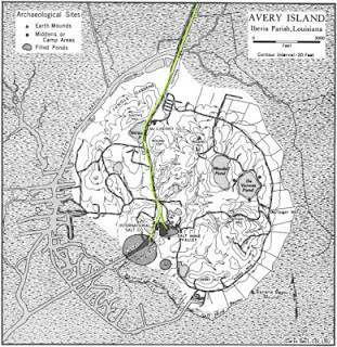 Map of Avery Island, Louisiana,
with railroad routes highlighted in yellow.
Source: Avery Island Inc. Archives
Avery Island is a salt dome in lower Iberia Parish, Louisiana. It's not an island in the traditional sense; that is, it's not surrounded by a body of open water. In fact, it's located about 3 miles inland from the nearest body of open water. But it is surrounded on all sides by wetlands — either grassy salt marsh, wooded cypress swamp, or slow-moving, muddy bayous.
The railroad came to Avery Island in 1883, primarily to serve the Island's salt mine. The railroad also served the factory that produced the world-famous TABASCO® brand Pepper Sauce. It, too, was (and still is) located on Avery Island.
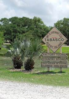 Photo by author
I took most of the photographs in this series on restricted private property with the permission of the landowners, McIlhenny Company & Avery Island Inc. (my employers).
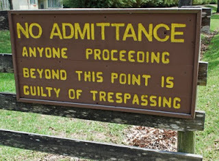 Photo by author
The railroad reached Avery Island by crossing this trestle bridge over Bayou Petite Anse (actually the confluence of Bayou Leleu and Stumpy Bayou, which in turn flows into the nearby Petite Anse). I took this photo around 2000.
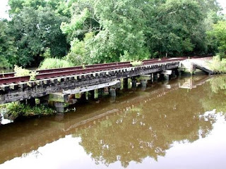 Photo by author
This is what the trestle bridge looks like today (May 2010). Hurricane Rita washed away the top part of the trestle in 2005. Because the railroad no longer serviced the Island by that time (the rails on the Island having been ripped up in 2002), no effort was made to repair the bridge. (By 2000 the salt mine used eighteen-wheelers and barges to transport salt; McIlhenny Company likewise used eighteen-wheelers to distribute TABASCO® Sauce.)
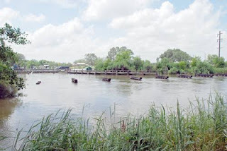 Photo by author
 Photo by author
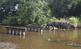 Photo by author
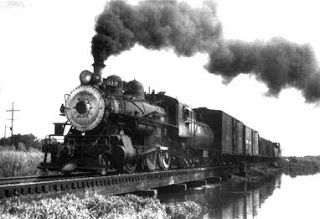
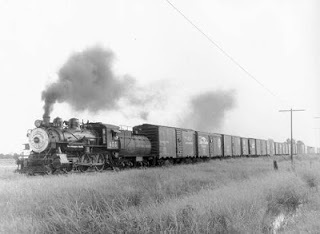
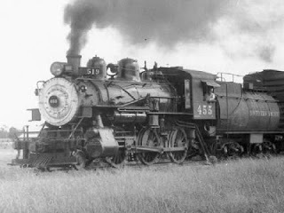
Here is Engine 455 crossing the same trestle bridge. This photo was taken in the early to mid-1950s; a diesel engine replaced Engine 455 around 1955.
 Source: Avery Island Inc. Archives
 Source: Avery Island Inc. Archives
 Source: Avery Island Inc. Archives
Although Engine 455 ended up in a Houston scrapyard, someone at Avery Island salvaged its headlamp, which now sits in the McIlhenny Company & Avery Island Inc. Archives.
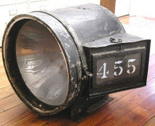 Photo by author
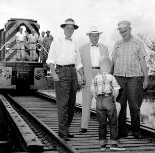
Here is a circa 1955 photo of the diesel engine that replaced Engine 455. As you can see, the diesel engine is crossing the trestle bridge that leads onto the Island. (The boy in the photo is reminding the railroad workers that they are entering private property; I have been told this ceremony occurred annually for legal reasons.)
 Source: Avery Island Inc. Archives
A few hundred yards down Stumpy Bayou are the trestle bridge parts washed away by Hurricane Rita.
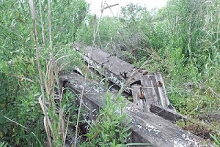 Photo by author
Note the marine life that had grown on the trestle. (My foot is in the image for scale.)
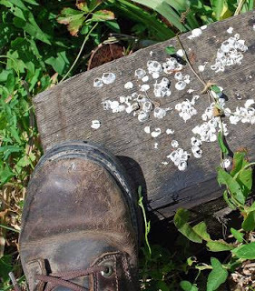 Photo by author
Here is the rail bed — the elevated whitish hump running between and parallel to the grass and bamboo — as it looks today, heading south on Avery Island toward the salt mine.
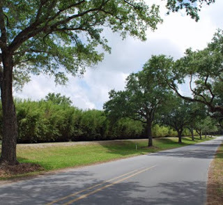 Photo by author
I took this photograph looking south on the same section of rail bed.
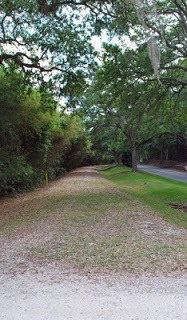 Photo by author
Moving south, I found a small section of track still in place at the entrance to the McIlhenny Company corporate office.
 Photo by author
Right past the corporate office stands the McIlhenny station sign. There was never an actual station here, however, because the TABASCO® factory itself was the "station." (The older part of our corporate office served as the TABASCO® Sauce factory from 1905 until around 1980.) Incidentally, the station sign that appears in this photo is a new replica. The original sign shows up in the next image below; it is now preserved in the Archives. [Actually, as of February 2016 the sign is on display in the Barrel Warehouse section of the new Tabasco Museum tour.]
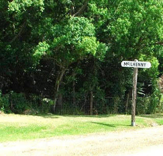 Photo by author
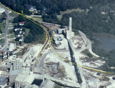
In this circa 2000 image of the same spot, you can make out the spur (see arrow) leading from the main line toward the TABASCO® factory.
 Photo by author
This is looking at the station sign from the opposite direction. The yellow lines on this present-day photo show where the main line and spur (at right) would have been located.
 Photo by author
Following the spur toward the old TABASCO® factory leads to some kind of device on the ground (which I assume is related to the railroad). [I have since learned that the device permitted TABASCO® factory workers to manually move boxcars back and forth along the spur.] The yellow line shows where the side track would have continued. As you can see, it would have gone right between the two buildings (where an enclosed walkway now stands). There the spur ended.
 Photo by author
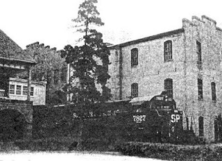
This photo, taken around 1980, shows a diesel engine on the track between the two buildings. TABASCO®-related material would have been loaded/unloaded from the train at this location.
 Source: McIlhenny Company Archives
A close-up image of the device that I assume to be railroad-related [See above bracketed note about the purpose of this device.]
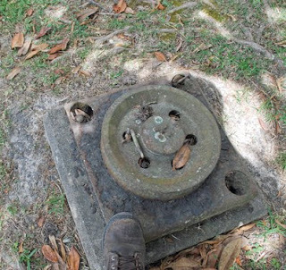 Photo by author
Heading south again on the Island, the rail bed passes this old sign with the number "9."
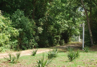 Photo by author
Moving farther south the two rails became six rails. (Note the third set of rails below the arrow.) I was told that the extra set was a siding. This picture was taken in 2000.
 Photo by author
Here is the same spot during the railroad’s demolition in 2002.
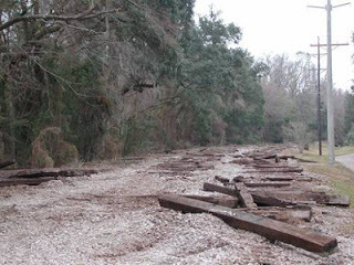 Photo by author
Here's another photo from the same area, showing the excavator and bulldozer that tore up the track; note the scrap in the dumpster.
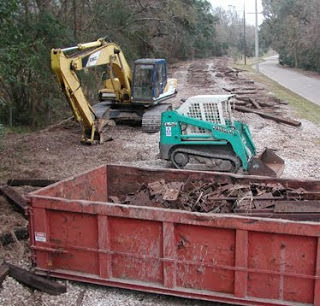 Photo by author
This is the same section of track, but looking in the opposite direction (north).
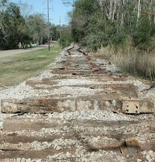 Photo by author
This is what that same area looks like today.
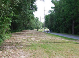 Photo by author
A close inspection of that spot reveals signs of its previous purpose — in this case, a railroad spike stuck in a rail plate.
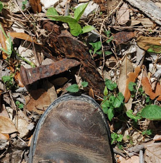 Photo by author
A few feet away is a rotting railroad tie that the demolition crew evidently forgot to pick up.
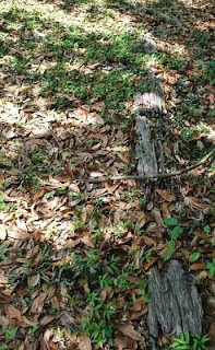 Photo by author
This switch, photographed in 2002 on the same stretch of railroad, is no longer to be found. [I have since been told that someone on the Island made this switch into a mailbox.]
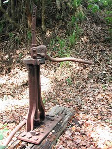 Photo by author
We're now getting close to the Avery Island salt mine, which I'm unsure was ever so crowded with trains as depicted in this circa 1940 advertisement. But perhaps it was, during the heyday of railroad transportation.
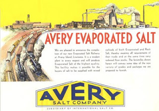 Source: Avery Island Inc. Archives
The rail bed reaches the salt mine and runs into this fence; note the salt mine structure in the background.
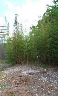 Photo by author
Looking back northward from the same spot reveals this presumably railroad-related sign reading "D."
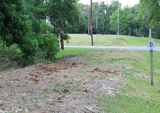 Photo by author
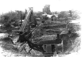
Here is an 1899 photo of the salt mine with box cars present.
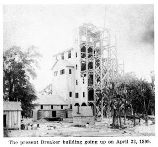 Source: Avery Island Inc. Archives
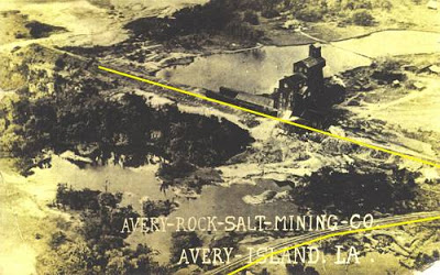
This circa 1930 aerial photo shows the salt mine; I've added yellow lines next to the railroad tracks. Note a spur leading off the main line.
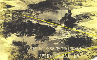 Source: Avery Island Inc. Archives
This circa 2000 photo shows the railroad as it continued onto the salt mine property. I don't know if these rails still exist today because I did not return to the salt mine lease. (Perhaps another day and, of course, only with permission of the salt mine lessee.)
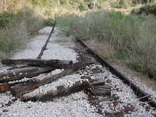 Photo by author
A close-up circa 2000 image of the rails on the salt mine lease. These could be rails from the 19th century or early 20th century, given their decrepit condition. Most of the rails ripped up in 2002 appeared in good condition — nothing at all like these rails.
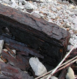 Photo by author
Backing up a little, I found the rails that made up the spur shown in the above circa 1930 aerial photo.
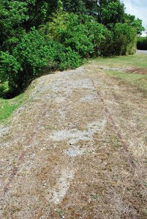 Photo by author
A close-up image of the spur rail as it appears today — almost buried beneath the topsoil.
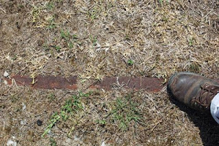 Photo by author
The spur rails lead into thick woods.
 Photo by author
This is where the spur rails once led: A gravel and sand pit on Avery Island. It shut down in 1917.
 Source: Avery Island Inc. Archives
Shane K. Bernard, Ph.D.
May 13, 2010
Avery Island, Louisiana
Addendum of 19 May 2010:
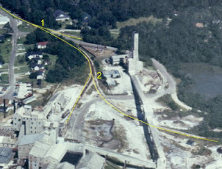 Source: Avery Island Inc. Archives
With help from others it's been determined for sure that spur #1 on this aerial photo is the spur that led to the old salt mine (dismantled after the mine caved-in at that location in the 1890s) and spur #2 is the spur that led to the sand/gravel pit that closed in 1917. This photo is interesting because it shows both spurs in the same image. Again, the rails that make up spur #1 remain in good condition as of last week; while the rails that make up spur #2 were in terrible shape when I last saw them several years ago.
My name is Shane K. Bernard and I'm the historian and curator for McIlhenny Company and Avery Island Inc., located on Avery Island, Louisiana.
 Map of Avery Island, Louisiana,
with railroad routes highlighted in yellow.
Source: Avery Island Inc. Archives
Avery Island is a salt dome in lower Iberia Parish, Louisiana. It's not an island in the traditional sense; that is, it's not surrounded by a body of open water. In fact, it's located about 3 miles inland from the nearest body of open water. But it is surrounded on all sides by wetlands — either grassy salt marsh, wooded cypress swamp, or slow-moving, muddy bayous.
The railroad came to Avery Island in 1883, primarily to serve the Island's salt mine. The railroad also served the factory that produced the world-famous TABASCO® brand Pepper Sauce. It, too, was (and still is) located on Avery Island.
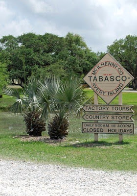 Photo by author
I took most of the photographs in this series on restricted private property with the permission of the landowners, McIlhenny Company & Avery Island Inc. (my employers).
 Photo by author
The railroad reached Avery Island by crossing this trestle bridge over Bayou Petite Anse (actually the confluence of Bayou Leleu and Stumpy Bayou, which in turn flows into the nearby Petite Anse). I took this photo around 2000.
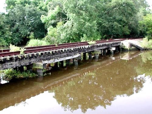 Photo by author
This is what the trestle bridge looks like today (May 2010). Hurricane Rita washed away the top part of the trestle in 2005. Because the railroad no longer serviced the Island by that time (the rails on the Island having been ripped up in 2002), no effort was made to repair the bridge. (By 2000 the salt mine used eighteen-wheelers and barges to transport salt; McIlhenny Company likewise used eighteen-wheelers to distribute TABASCO® Sauce.)
 Photo by author
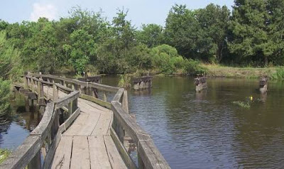 Photo by author
 Photo by author
Here is Engine 455 crossing the same trestle bridge. This photo was taken in the early to mid-1950s; a diesel engine replaced Engine 455 around 1955.
 Source: Avery Island Inc. Archives
 Source: Avery Island Inc. Archives
 Source: Avery Island Inc. Archives
Although Engine 455 ended up in a Houston scrapyard, someone at Avery Island salvaged its headlamp, which now sits in the McIlhenny Company & Avery Island Inc. Archives.
 Photo by author
Here is a circa 1955 photo of the diesel engine that replaced Engine 455. As you can see, the diesel engine is crossing the trestle bridge that leads onto the Island. (The boy in the photo is reminding the railroad workers that they are entering private property; I have been told this ceremony occurred annually for legal reasons.)
 Source: Avery Island Inc. Archives
A few hundred yards down Stumpy Bayou are the trestle bridge parts washed away by Hurricane Rita.
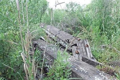 Photo by author
Note the marine life that had grown on the trestle. (My foot is in the image for scale.)
 Photo by author
Here is the rail bed — the elevated whitish hump running between and parallel to the grass and bamboo — as it looks today, heading south on Avery Island toward the salt mine.
 Photo by author
I took this photograph looking south on the same section of rail bed.
 Photo by author
Moving south, I found a small section of track still in place at the entrance to the McIlhenny Company corporate office.
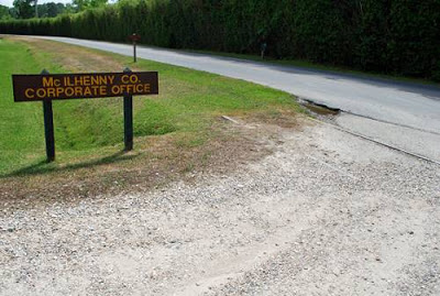 Photo by author
Right past the corporate office stands the McIlhenny station sign. There was never an actual station here, however, because the TABASCO® factory itself was the "station." (The older part of our corporate office served as the TABASCO® Sauce factory from 1905 until around 1980.) Incidentally, the station sign that appears in this photo is a new replica. The original sign shows up in the next image below; it is now preserved in the Archives. [Actually, as of February 2016 the sign is on display in the Barrel Warehouse section of the new Tabasco Museum tour.]
 Photo by author
In this circa 2000 image of the same spot, you can make out the spur (see arrow) leading from the main line toward the TABASCO® factory.
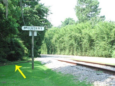 Photo by author
This is looking at the station sign from the opposite direction. The yellow lines on this present-day photo show where the main line and spur (at right) would have been located.
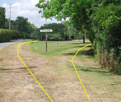 Photo by author
Following the spur toward the old TABASCO® factory leads to some kind of device on the ground (which I assume is related to the railroad). [I have since learned that the device permitted TABASCO® factory workers to manually move boxcars back and forth along the spur.] The yellow line shows where the side track would have continued. As you can see, it would have gone right between the two buildings (where an enclosed walkway now stands). There the spur ended.
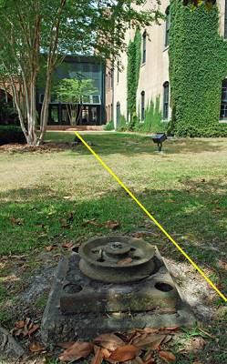 Photo by author
This photo, taken around 1980, shows a diesel engine on the track between the two buildings. TABASCO®-related material would have been loaded/unloaded from the train at this location.
 Source: McIlhenny Company Archives
A close-up image of the device that I assume to be railroad-related [See above bracketed note about the purpose of this device.]
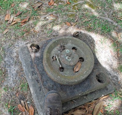 Photo by author
Heading south again on the Island, the rail bed passes this old sign with the number "9."
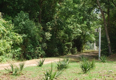 Photo by author
Moving farther south the two rails became six rails. (Note the third set of rails below the arrow.) I was told that the extra set was a siding. This picture was taken in 2000.
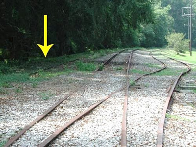 Photo by author
Here is the same spot during the railroad’s demolition in 2002.
 Photo by author
Here's another photo from the same area, showing the excavator and bulldozer that tore up the track; note the scrap in the dumpster.
 Photo by author
This is the same section of track, but looking in the opposite direction (north).
 Photo by author
This is what that same area looks like today.
 Photo by author
A close inspection of that spot reveals signs of its previous purpose — in this case, a railroad spike stuck in a rail plate.
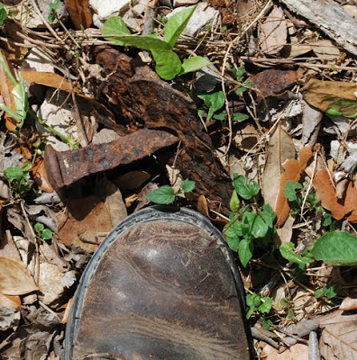 Photo by author
A few feet away is a rotting railroad tie that the demolition crew evidently forgot to pick up.
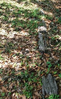 Photo by author
This switch, photographed in 2002 on the same stretch of railroad, is no longer to be found. [I have since been told that someone on the Island made this switch into a mailbox.]
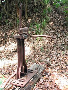 Photo by author
We're now getting close to the Avery Island salt mine, which I'm unsure was ever so crowded with trains as depicted in this circa 1940 advertisement. But perhaps it was, during the heyday of railroad transportation.
 Source: Avery Island Inc. Archives
The rail bed reaches the salt mine and runs into this fence; note the salt mine structure in the background.
 Photo by author
Looking back northward from the same spot reveals this presumably railroad-related sign reading "D."
 Photo by author
Here is an 1899 photo of the salt mine with box cars present.
 Source: Avery Island Inc. Archives
This circa 1930 aerial photo shows the salt mine; I've added yellow lines next to the railroad tracks. Note a spur leading off the main line.
 Source: Avery Island Inc. Archives
This circa 2000 photo shows the railroad as it continued onto the salt mine property. I don't know if these rails still exist today because I did not return to the salt mine lease. (Perhaps another day and, of course, only with permission of the salt mine lessee.)
 Photo by author
A close-up circa 2000 image of the rails on the salt mine lease. These could be rails from the 19th century or early 20th century, given their decrepit condition. Most of the rails ripped up in 2002 appeared in good condition — nothing at all like these rails.
 Photo by author
Backing up a little, I found the rails that made up the spur shown in the above circa 1930 aerial photo.
 Photo by author
A close-up image of the spur rail as it appears today — almost buried beneath the topsoil.
 Photo by author
The spur rails lead into thick woods.
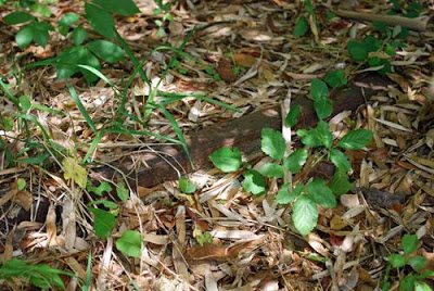 Photo by author
This is where the spur rails once led: A gravel and sand pit on Avery Island. It shut down in 1917.
 Source: Avery Island Inc. Archives
Shane K. Bernard, Ph.D.
May 13, 2010
Avery Island, Louisiana
Addendum of 19 May 2010:
 Source: Avery Island Inc. Archives
With help from others it's been determined for sure that spur #1 on this aerial photo is the spur that led to the old salt mine (dismantled after the mine caved-in at that location in the 1890s) and spur #2 is the spur that led to the sand/gravel pit that closed in 1917. This photo is interesting because it shows both spurs in the same image. Again, the rails that make up spur #1 remain in good condition as of last week; while the rails that make up spur #2 were in terrible shape when I last saw them several years ago.
January 1, 2016
Here you can purchase my books about south Louisiana...

Here you can purchase my books about south Louisiana history and culture.
Scroll down to see all items. . . .


Paperback editionKindle edition
"[A] thoroughly researched and well-documented book" ~ Publisher's Weekly
"Bernard makes good use of the musical connections that few others would have. . . . [It is] a desirable selection for ethnic music and regional collections" ~ Library Journal


Paperback editionAudiobook editionKindle edition
"The strength of this study rests in the way Bernard follows the effects of postwar changes as they ripple through Cajun culture. . . . Bernard, as both scholar and participant, has written a thorough and interesting study of that transformation." ~ Journal of Southern History
"Bernard has done an excellent job in treating this neglected aspect of Cajun history. . . . This reviewer highly recommends this immensely readable and informative volume to anyone interested in learning more about one of America’s most fascinating peoples." ~ The Journal of American History

Hardcover editionAudiobook editionKindle edition
Recipient of 2017 Book of the Year award presented by the Louisiana Endowment for the Humanities.
"Aided by the vividness of the history he describes, Bernard tells a gripping story, centered on the narrative of the people who live along the Teche." ~ Country Roads Magazine
"Bernard has invited his readers to know the Teche better, and in that he very much succeeds. . . . [A]n enjoyable and well-written book that introduces readers to a waterway whose history is 'much more significant than its size would at first suggest.' The maps and images are well chosen and well placed, and the text is well written, well researched, and peppered with interesting anecdotes. Readers with an interest in local history or Louisiana history will certainly welcome this book, but there is a place for it as well on the shelves of readers with a broader interest in southern history or riparian history." ~ Louisiana History

English hardcover editionEnglish Kindle edition
French hardcover editionFrench Kindle edition
"[C]lear, accurate, and engaging. . . . [T]he book will be a welcome contribution to school libraries and will serve as an excellent reference for reports and early research papers within secondary curricula." ~ Journal of Folklore Research Reviews
"[A] brief but delightfully engaging account of who the Cajuns are and how they got that way, a narrative as informative as it is easy to navigate. . . . [It] fills an important gap on the Louisiana history bookshelf, and its value can be appreciated by the not-so-young as well." ~ New Orleans Times-Picayune

Hardcover edition
"Serious Tabasco fans are no doubt salivating over this hardcover story of Louisiana's McIlhenny family and their iconic hot stuff. Bernard. . . peppers the volume with rarely seen photos, documents and lush illustrations right out of the company archives. . . ." ~ Atlanta Journal-Constitution
"It's easy to say this is a hot holiday book. The coffee-table tome includes history, ads and trivia — a "Tabasco in Hollywood" section tells us the sauce appeared on film with Laurel & Hardy, Bugs Bunny, the Little Rascals and James Bond and even in 'Apocalypse Now.' Our fave picture is a 1954 poster in English and Hebrew boasting 'The Only Pepper Sauce Under Rabbinical Supervision.'" ~ New York Post
[A] lavish, entrancing book . . . tracing the fabled condiment's history, the family, marketing and more." ~ New Orleans Times-Picayune
Here you can purchase my books as well as items I de...

Here you can purchase my books as well as items I designed with south Louisiana's intriguing history and culture in mind — including (on the lower half of this page) decals, shirts, mugs, hats, and posters.
Scroll down to see all items. . . .
Paperback editionKindle edition
"[A] thoroughly researched and well-documented book" ~ Publisher's Weekly
"Bernard makes good use of the musical connections that few others would have. . . . [It is] a desirable selection for ethnic music and regional collections" ~ Library Journal
Paperback editionAudiobook editionKindle edition
"The strength of this study rests in the way Bernard follows the effects of postwar changes as they ripple through Cajun culture. . . . Bernard, as both scholar and participant, has written a thorough and interesting study of that transformation." ~ Journal of Southern History
"Bernard has done an excellent job in treating this neglected aspect of Cajun history. . . . This reviewer highly recommends this immensely readable and informative volume to anyone interested in learning more about one of America’s most fascinating peoples." ~ The Journal of American History
Hardcover editionAudiobook editionKindle edition
Recipient of 2017 Book of the Year award presented by the Louisiana Endowment for the Humanities.
"Aided by the vividness of the history he describes, Bernard tells a gripping story, centered on the narrative of the people who live along the Teche." ~ Country Roads Magazine
"Bernard has invited his readers to know the Teche better, and in that he very much succeeds. . . . [A]n enjoyable and well-written book that introduces readers to a waterway whose history is 'much more significant than its size would at first suggest.' The maps and images are well chosen and well placed, and the text is well written, well researched, and peppered with interesting anecdotes. Readers with an interest in local history or Louisiana history will certainly welcome this book, but there is a place for it as well on the shelves of readers with a broader interest in southern history or riparian history." ~ Louisiana History
English hardcover editionEnglish Kindle edition
French hardcover editionFrench Kindle edition
"[C]lear, accurate, and engaging. . . . [T]he book will be a welcome contribution to school libraries and will serve as an excellent reference for reports and early research papers within secondary curricula." ~ Journal of Folklore Research Reviews
"[A] brief but delightfully engaging account of who the Cajuns are and how they got that way, a narrative as informative as it is easy to navigate. . . . [It] fills an important gap on the Louisiana history bookshelf, and its value can be appreciated by the not-so-young as well." ~ New Orleans Times-Picayune
Hardcover edition
"Serious Tabasco fans are no doubt salivating over this hardcover story of Louisiana's McIlhenny family and their iconic hot stuff. Bernard. . . peppers the volume with rarely seen photos, documents and lush illustrations right out of the company archives. . . ." ~ Atlanta Journal-Constitution
"It's easy to say this is a hot holiday book. The coffee-table tome includes history, ads and trivia — a "Tabasco in Hollywood" section tells us the sauce appeared on film with Laurel & Hardy, Bugs Bunny, the Little Rascals and James Bond and even in 'Apocalypse Now.' Our fave picture is a 1954 poster in English and Hebrew boasting 'The Only Pepper Sauce Under Rabbinical Supervision.'" ~ New York Post
[A] lavish, entrancing book . . . tracing the fabled condiment's history, the family, marketing and more." ~ New Orleans Times-Picayune

Cajuns Since 1764 oval decal(printed on vinyl with premium inks that resist the elements)

Acadians Since 1604 oval decal(printed on vinyl with premium inks that resist the elements)

Les Acadiens Depuis 1604 oval decal
(printed on vinyl with premium inks that resist the elements)

Cajuns Since 1764 men's classic T-shirtor women's classic T-shirt

Acadians Since 1604 men's classic T-shirtor women's classic T-shirt

Les Acadiens Depuis 1604 men's classic T-shirtor women's classic T-shirt

Cajuns Since 1764 mug

Acadians Since 1604 mug

Les Acadiens Depuis 1604 mug
 Cajuns Since 1764 baseball cap

Acadians Since 1604 baseball cap

Les Acadiens Depuis 1604 baseball cap

1755 Acadian History Poster, Unframed Print(Image size 23" X 35")
1755 Acadian History Poster, Framed Panel Print(Frame size: 13" x 16")
Questions or comments about all non-book items should be directed to CafePress.

All CafePress designs on decals, shirts, mugs, hats, posters, etc., are Copyright © Shane K. Bernard 2018
Here you can purchase my books as well as items I ...
Here you can purchase my books as well as items I designed with south Louisiana's intriguing history and culture in mind — including (on the lower half of this page) decals, shirts, mugs, hats, and posters.
Scroll down to see all items. . . .
Paperback editionKindle edition
"[A] thoroughly researched and well-documented book" ~ Publisher's Weekly
"Bernard makes good use of the musical connections that few others would have. . . . [It is] a desirable selection for ethnic music and regional collections" ~ Library Journal
Paperback editionAudiobook editionKindle edition
"The strength of this study rests in the way Bernard follows the effects of postwar changes as they ripple through Cajun culture. . . . Bernard, as both scholar and participant, has written a thorough and interesting study of that transformation." ~ Journal of Southern History
"Bernard has done an excellent job in treating this neglected aspect of Cajun history. . . . This reviewer highly recommends this immensely readable and informative volume to anyone interested in learning more about one of America’s most fascinating peoples." ~ The Journal of American History
Hardcover editionAudiobook editionKindle edition
"Aided by the vividness of the history he describes, Bernard tells a gripping story, centered on the narrative of the people who live along the Teche." ~ Country Roads Magazine
Recipient of 2017 Book of the Year award presented by the Louisiana Endowment for the Humanities.
English hardcover editionEnglish Kindle edition
French hardcover editionFrench Kindle edition
"[C]lear, accurate, and engaging. . . . [T]he book will be a welcome contribution to school libraries and will serve as an excellent reference for reports and early research papers within secondary curricula." ~ Journal of Folklore Research Reviews
"[A] brief but delightfully engaging account of who the Cajuns are and how they got that way, a narrative as informative as it is easy to navigate. . . . [It] fills an important gap on the Louisiana history bookshelf, and its value can be appreciated by the not-so-young as well." ~ New Orleans Times-Picayune
Hardcover edition
"Serious Tabasco fans are no doubt salivating over this hardcover story of Louisiana's McIlhenny family and their iconic hot stuff. Bernard. . . peppers the volume with rarely seen photos, documents and lush illustrations right out of the company archives. . . ." ~ Atlanta Journal-Constitution
"It's easy to say this is a hot holiday book. The coffee-table tome includes history, ads and trivia — a "Tabasco in Hollywood" section tells us the sauce appeared on film with Laurel & Hardy, Bugs Bunny, the Little Rascals and James Bond and even in 'Apocalypse Now.' Our fave picture is a 1954 poster in English and Hebrew boasting 'The Only Pepper Sauce Under Rabbinical Supervision.'" ~ New York Post
[A] lavish, entrancing book . . . tracing the fabled condiment's history, the family, marketing and more." ~ New Orleans Times-Picayune
Cajuns Since 1764 oval decal(printed on vinyl with premium inks that resist the elements)
Acadians Since 1604 oval decal(printed on vinyl with premium inks that resist the elements)
Les Acadiens Depuis 1604 oval decal
(printed on vinyl with premium inks that resist the elements)
Cajuns Since 1764 men's classic T-shirtor women's classic T-shirt
Acadians Since 1604 men's classic T-shirtor women's classic T-shirt
Les Acadiens Depuis 1604 men's classic T-shirtor women's classic T-shirt
Cajuns Since 1764 mug
Acadians Since 1604 mug
Les Acadiens Depuis 1604 mug
Cajuns Since 1764 baseball cap
Acadians Since 1604 baseball cap
Les Acadiens Depuis 1604 baseball cap
1755 Acadian History Poster, Unframed Print(Image size 23" X 35")
1755 Acadian History Poster, Framed Panel Print(Frame size: 13" x 16")
Questions or comments about all non-book items should be directed to CafePress.
All CafePress designs on decals, shirts, mugs, hats, posters, etc., are Copyright © Shane K. Bernard 2018
Welcome to the Bayou Teche Dispatches Store. . . .He...
Welcome to the
Bayou Teche Dispatches Store. . . .
Here you can purchase my books as well as items I designed with south Louisiana's intriguing history and culture in mind — including (on the lower half of this page) decals, shirts, mugs, hats, and posters.
Scroll down to see all items. . . .

Paperback editionKindle edition
"[A] thoroughly researched and well-documented book" ~ Publisher's Weekly
"Bernard makes good use of the musical connections that few others would have. . . . [It is] a desirable selection for ethnic music and regional collections" ~ Library Journal


Paperback editionAudiobook editionKindle edition
"The strength of this study rests in the way Bernard follows the effects of postwar changes as they ripple through Cajun culture. . . . Bernard, as both scholar and participant, has written a thorough and interesting study of that transformation." ~ Journal of Southern History
"Bernard has done an excellent job in treating this neglected aspect of Cajun history. . . . This reviewer highly recommends this immensely readable and informative volume to anyone interested in learning more about one of America’s most fascinating peoples." ~ The Journal of American History

Hardcover editionAudiobook editionKindle edition
"Aided by the vividness of the history he describes, Bernard tells a gripping story, centered on the narrative of the people who live along the Teche." ~ Country Roads Magazine
Recipient of 2017 Book of the Year award presented by the Louisiana Endowment for the Humanities.

English hardcover editionEnglish Kindle edition
French hardcover editionFrench Kindle edition
"[C]lear, accurate, and engaging. . . . [T]he book will be a welcome contribution to school libraries and will serve as an excellent reference for reports and early research papers within secondary curricula." ~ Journal of Folklore Research Reviews
"[A] brief but delightfully engaging account of who the Cajuns are and how they got that way, a narrative as informative as it is easy to navigate. . . . [It] fills an important gap on the Louisiana history bookshelf, and its value can be appreciated by the not-so-young as well." ~ New Orleans Times-Picayune

Hardcover edition
"Serious Tabasco fans are no doubt salivating over this hardcover story of Louisiana's McIlhenny family and their iconic hot stuff. Bernard. . . peppers the volume with rarely seen photos, documents and lush illustrations right out of the company archives. . . ." ~ Atlanta Journal-Constitution
"It's easy to say this is a hot holiday book. The coffee-table tome includes history, ads and trivia — a "Tabasco in Hollywood" section tells us the sauce appeared on film with Laurel & Hardy, Bugs Bunny, the Little Rascals and James Bond and even in 'Apocalypse Now.' Our fave picture is a 1954 poster in English and Hebrew boasting 'The Only Pepper Sauce Under Rabbinical Supervision.'" ~ New York Post
[A] lavish, entrancing book . . . tracing the fabled condiment's history, the family, marketing and more." ~ New Orleans Times-Picayune
Cajuns Since 1764 oval decal(printed on vinyl with premium inks that resist the elements)
Acadians Since 1604 oval decal(printed on vinyl with premium inks that resist the elements)
Les Acadiens Depuis 1604 oval decal
(printed on vinyl with premium inks that resist the elements)
Cajuns Since 1764 men's classic T-shirtor women's classic T-shirt
Acadians Since 1604 men's classic T-shirtor women's classic T-shirt
Les Acadiens Depuis 1604 men's classic T-shirtor women's classic T-shirt
Cajuns Since 1764 mug
Acadians Since 1604 mug
Les Acadiens Depuis 1604 mug
Cajuns Since 1764 baseball cap
Acadians Since 1604 baseball cap
Les Acadiens Depuis 1604 baseball cap
Questions or comments about all non-book items should be directed to CafePress.
All CafePress designs on decals, shirts, mugs, hats, posters, etc., are Copyright © Shane K. Bernard 2018
Bayou Teche Dispatches Store. . . .
Here you can purchase my books as well as items I designed with south Louisiana's intriguing history and culture in mind — including (on the lower half of this page) decals, shirts, mugs, hats, and posters.
Scroll down to see all items. . . .
Paperback editionKindle edition
"[A] thoroughly researched and well-documented book" ~ Publisher's Weekly
"Bernard makes good use of the musical connections that few others would have. . . . [It is] a desirable selection for ethnic music and regional collections" ~ Library Journal
Paperback editionAudiobook editionKindle edition
"The strength of this study rests in the way Bernard follows the effects of postwar changes as they ripple through Cajun culture. . . . Bernard, as both scholar and participant, has written a thorough and interesting study of that transformation." ~ Journal of Southern History
"Bernard has done an excellent job in treating this neglected aspect of Cajun history. . . . This reviewer highly recommends this immensely readable and informative volume to anyone interested in learning more about one of America’s most fascinating peoples." ~ The Journal of American History
Hardcover editionAudiobook editionKindle edition
"Aided by the vividness of the history he describes, Bernard tells a gripping story, centered on the narrative of the people who live along the Teche." ~ Country Roads Magazine
Recipient of 2017 Book of the Year award presented by the Louisiana Endowment for the Humanities.
English hardcover editionEnglish Kindle edition
French hardcover editionFrench Kindle edition
"[C]lear, accurate, and engaging. . . . [T]he book will be a welcome contribution to school libraries and will serve as an excellent reference for reports and early research papers within secondary curricula." ~ Journal of Folklore Research Reviews
"[A] brief but delightfully engaging account of who the Cajuns are and how they got that way, a narrative as informative as it is easy to navigate. . . . [It] fills an important gap on the Louisiana history bookshelf, and its value can be appreciated by the not-so-young as well." ~ New Orleans Times-Picayune
Hardcover edition
"Serious Tabasco fans are no doubt salivating over this hardcover story of Louisiana's McIlhenny family and their iconic hot stuff. Bernard. . . peppers the volume with rarely seen photos, documents and lush illustrations right out of the company archives. . . ." ~ Atlanta Journal-Constitution
"It's easy to say this is a hot holiday book. The coffee-table tome includes history, ads and trivia — a "Tabasco in Hollywood" section tells us the sauce appeared on film with Laurel & Hardy, Bugs Bunny, the Little Rascals and James Bond and even in 'Apocalypse Now.' Our fave picture is a 1954 poster in English and Hebrew boasting 'The Only Pepper Sauce Under Rabbinical Supervision.'" ~ New York Post
[A] lavish, entrancing book . . . tracing the fabled condiment's history, the family, marketing and more." ~ New Orleans Times-Picayune

Cajuns Since 1764 oval decal(printed on vinyl with premium inks that resist the elements)

Acadians Since 1604 oval decal(printed on vinyl with premium inks that resist the elements)

Les Acadiens Depuis 1604 oval decal
(printed on vinyl with premium inks that resist the elements)

Cajuns Since 1764 men's classic T-shirtor women's classic T-shirt

Acadians Since 1604 men's classic T-shirtor women's classic T-shirt

Les Acadiens Depuis 1604 men's classic T-shirtor women's classic T-shirt

Cajuns Since 1764 mug

Acadians Since 1604 mug

Les Acadiens Depuis 1604 mug
 Cajuns Since 1764 baseball cap

Acadians Since 1604 baseball cap

Les Acadiens Depuis 1604 baseball cap
Questions or comments about all non-book items should be directed to CafePress.
All CafePress designs on decals, shirts, mugs, hats, posters, etc., are Copyright © Shane K. Bernard 2018
April 19, 2014
Sur le Teche: Exploring the Bayou by Canoe, Stage 7
Continued from Part VI:
Keith and I set out on the seventh stage of our journey down Bayou Teche on November 3, 2012, at 9:40 a.m., starting from where we left off last time just south of Franklin. The morning temperature was 57 °F; the afternoon temperature, a balmy 84 °F.
 Aerial photograph of stage 7,
Far side of Franklin to Calumet.
(Click to enlarge)
(Source: Google Maps)
We shortly spotted a narrow channel running west from the Teche — the Hanson Canal and Lock (29.77261, -91.483286), "[b]uilt in 1907 by the Hanson Lumber Company," according to research by the American Canal Society, "to float log booms from the delta into Bayou Teche." (By "the delta" I assume the ACS meant that of the nearby Atchafalaya River.) In 1922 Hanson Lumber Company sold the lock to the U.S. government, which entrusted its operation to the Army Corps of Engineers. In 1959 the federal government abandoned the lock, which now sits frozen in the "open" position as a vestige of the Teche region's once prosperous but now extinct logging industry.
By 10 a.m. the sun reflected blindingly off the water. We paddled past suburban homes on the west bank, forest on the east. A glance at an aerial photograph, however, revealed that just beyond that wildwood lay enormous swathes of sugarcane. It was already the beginning of harvest and that cane would shortly be cut and ground, its extract boiled and reboiled and processed into raw granulated sugar.
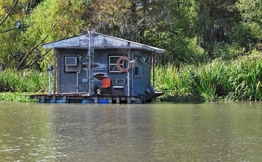 Fishing camp on the Teche that day.
(Photograph by author)
An increasing number of suburban homes on the west bank meant we approached Garden City (29.765279, -91.465889), a community of several dozen houses and a few industrial buildings. Like Franklin, Garden City makes a short appearance in the classic counterculture movie Easy Rider. By "short" I mean three seconds. Those three seconds show an American flag hanging from a whitewashed, wood-framed U.S. Post Office. Although no longer a public building, the structure still stands, with an American flag hanging from the exact same spot as shown in the movie. This flag went up not too long ago, and if I had to guess I'd say the building's current owner hung it there as a paean to Easy Rider.
 The old boiler.
(Photograph by author)
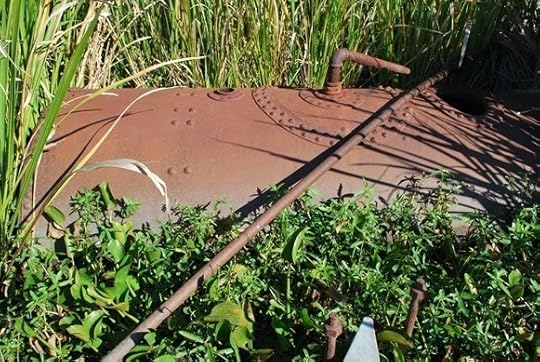
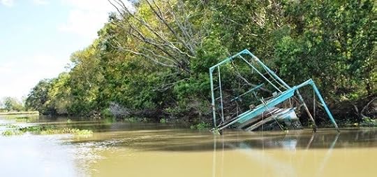
Around 10:20 a.m. Keith and I reached Frances Plantation, whose Creole-style "big house," built around 1810, stands on the west bank. In the bayou almost directly across from the house Keith and I spotted a rusty iron boiler (29.767817, -91.463067) half sunken amid a stand of cord grass. Paddling over to the artifact, we eyeballed it at about four feet in diameter and about twelve feet in length. Although it could have originated in a sugarhouse, we believe it came from a steamboat — and that the spot on which it sat encompassed the wreck of a steamboat. We came to this conclusion because several pairs of large iron bolts protruded from the Teche, running in tandem from the boiler toward a few sheets of corroded iron several yards away. A metal cable rested atop these sheets like a dark sunning snake. Using our canoe as a yardstick, Keith and I measured this chain of presumably related artifacts — the boiler, the pairs of bolts, the sheets of metal, the cable — and altogether they extended about 85 feet along the waterway: the length of a modest-sized steamboat.
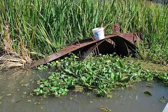 Sheets of corroded iron near boiler.
(Photograph by author)
Later I queried local history enthusiasts about these artifacts and checked inventories of known sunken vessels on the bayou. No one knew anything about them, nor did they appear on the 1870 survey of the Teche, even though it noted every visible obstruction on the bayou (down to individual stumps and logs). This suggested the boiler and other artifacts date to after the 1870 survey. Regardless, the identity of this steamboat — if that’s indeed what it is — remains a mystery.
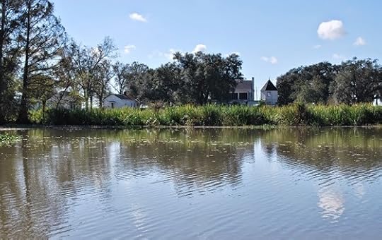 Frances Plantation from the bayou.
(Photograph by author)
After documenting these artifacts, Keith and I paddled farther down the Teche and soon reached Centerville (29.75987, -91.428401) and right beyond it the community of Verdunville (29.75402, -91.401114). Suburban houses stood on both banks. Here we spotted many scattered juglines using cabbage-sized Styrofoam balls as "bobbers." We soon caught up with a motorboater checking these lines; he proudly informed us he’d caught 20 blue catfish so far that day.
 Juglines on the Teche that day.
(Photograph by author)
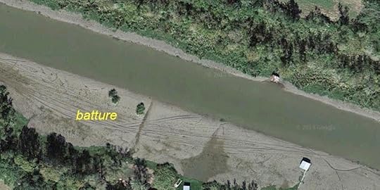
After a short distance Keith noticed the western side of the bayou had become very shallow. Sticking his paddle into the hazy water, he touched bottom only about a foot below the surface. Spindly bamboo poles rose from the Teche along this stretch, apparently outlining the shoal for unfamiliar boaters. Aerial photographs indicate that when the bayou is low this shoal becomes a lengthy batture(which, as I mentioned previously, refers to marshy land between the water’s edge and the bank of the bayou).
 Bamboo poles marking the shoals.
(Photograph by author)
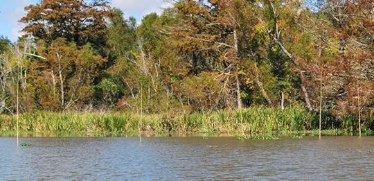
We soon noticed shoals on both sides of the Teche and, sprouting from the shoals’ slimy mud, fingers of aquatic plants twisting in the current like seaweed.
 The Teche around Verdunville when low.
Note the batture takes up nearly half the riverbed in this image.
When we canoed it, about a foot of water covered this batture.
(Photograph by author)
Around noon we passed the mouth of the Verdunville Canal (29.756218, -91.398575), which runs northeast a short distance to the Atchafalaya Basin Levee. Within sight of the canal the Teche dips southward toward Ricohoc and Calumet, clusters of houses taking their names from local sugar plantations.
About 1 pm Keith and I steered left at a fork in the bayou (29.705574, -91.378969), paddled our canoe through the open west flood gate, and entered the wide expanse of the Wax Lake Outlet.
 The fork in the bayou.
(Photograph by author)
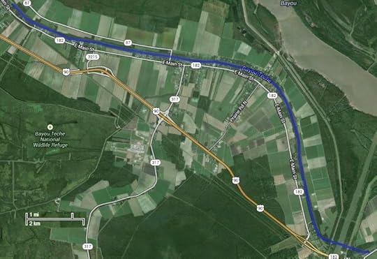
Located directly between Ricohoc and Calumet, Wax Lake Outlet (29.701511, -91.372482), sometimes also called the Calumet Cut, is a massive man-made channel. Completed in the early 1940s by the Army Corps of Engineers, the Outlet runs about sixteen miles in length and stretches roughly six hundred feet in width. It was designed to spare Morgan City from floods by diverting water from the Atchafalaya River to the nearby Gulf of Mexico. The Corps drove the Outlet across the path of the Teche and, unfortunately, through the remains of the Civil War redoubt known as Camp Bisland (located as best I can tell around 29.700355,-91.373905) — thus demonstrating the need for environmental impact studies. (If by chance the the Outlet did not plow right through the fort, the ruin nonetheless would have ended up buried beneath the monumental levee that shadows the Outlet.)
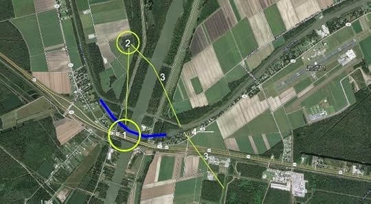 Battle of Bisland (approximate locations):
1) Fort Bisland;
2) smaller redoubt (connected to fort by trench);
3) Confederate forward entrenchments.
Blue line shows original course of Teche.
Union attacked from northeast following bayou.
(Click to enlarge)
(Source: Google Maps)
The Corps also diverted about a one-mile stretch of the Teche, damming up the bayou’s natural bend at Ricohoc/Calumet and replacing it with a straight detour through two modern flood gates. (I have been educated about these structures by a venerable boat builder of the region: they are not locks, as I initially took to calling them, because they have no chambers in which to raise and lower the water level; rather, they are flood gates, which close when swelling water in the Outlet threatens to deluge the Teche.)
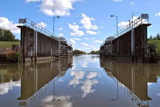 West flood gate on the Teche at Wax Lake Outlet.
(Photograph by author)
The Louisiana Highway Department had previously run Highway 90 through the same narrow neck of high land — the natural Teche Ridge — so that today the Outlet, detour, flood gates, and highway (as well as a preexisting railroad) all nearly come together at a single point. It had to be this way, because except for this ridge the entire area is flood-prone cypress swamp. This is why the Confederates erected Fort Bisland on this spot: it presented an easily defendable bottleneck along the course of the Teche.
 Looking up the Wax Lake Outlet
as we paddled across it.
(Photograph by author)
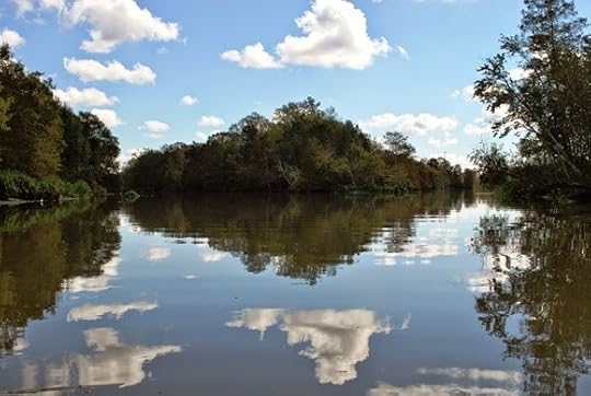
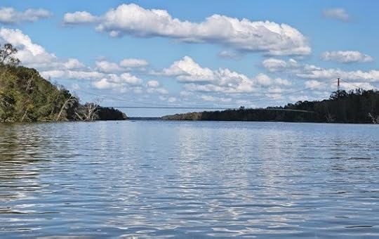
After the narrowness of the Teche, the Wax Lake Outlet seemed vast like the Mississippi River. Yet we could see on the opposite bank, not too far ahead, the open east flood gate and, beyond it, the continuing path of the Teche.
This crossing had worried me for months. As I noted in a previous entry, the Outlet’s current could be treacherous. In fact, the annual Tour du Teche canoe, kayak, and pirogue race posts "safety boats" in the Outlet in case contestants run into trouble — the only place it does so for the entire 135-mile course. Race officials also permit contestants to opt out of crossing the Outlet, without penalty, should they find the passage too dangerous. As a local newspaper reported, "Wax Lake Outlet is the most daunting single obstacle in the Tour. . . . With a sometimes raging current, [it] is nothing to trifle with."
Fortunately, the Outlet was subdued that day, and Keith and I cruised across it as though it didn’t even exist. We encountered turbulence only around the two flood gates, where the waters of the Teche and the Outlet converged. There we saw roiling eddies and little whirlpools that swirled into and out of existence. Making strong, deliberate strokes, we paddled through these eruptions and shortly glided into smoother water.
 On the Teche again,
beyond the east flood gate.
(Photograph by author)
Again we came to a fork (29.701026, -91.364292). The right, we knew, was the old channel, now a dead end; the left, however, led farther down the Teche. We steered the latter course and looked for a place to stop for the day. Keith and I had planned to stop at the east floodgate — but we unexpectedly found the banks fenced off by the parish and federal governments. So instead we plowed through a mass of reeds and hyacinths to stop at an empty lot next to a house on the east bank. Beyond the lot and house ran Highway 182, which led back to our homes far up the Teche.
We covered a little more than 10.75 miles that day in about 3.75 hours.
While Keith unloaded our supplies I walked to the house to ask if we could cross the lot to reach the highway.
Permission granted.
As I returned to the canoe I did something I would later regret: using my cell phone I photographed a "For Sale" sign in front of the house. It gave the homeowner’s phone number, which I would need in order to ask permission to start our next and final leg from same adjoining lot. (More about this later.)
Keith and I awaited our ride on the side of the road at Calumet, our backs to the bayou. To our front stood a wide plain covered entirely in stalks of ripe sugarcane.
 Site of the Battle of Bisland,
Calumet, Louisiana.
(Photograph by author)
We were, however, in the middle of the Fort Bisland battleground (approximately 29.702517, -91.350302). The fort, as I mentioned, had been destroyed by the digging of the Wax Lake Outlet — yet most of the fighting had actually occurred about a mile east of the stronghold. Right where we stood. If Keith and I had materialized at that exact spot 149 years earlier, we would have been blown away by shell, shot, and minie balls fired by either combatant. Despite the Outlet, the highway, and the other modern improvements at Ricohoc/Calument, the battlefield proper remains, now as then, planted in cane, and would have looked much the same to the soldiers in the furrows and trenches as it did to us.
How many scattered bones had we paddled over, I wondered? How many shell fragments and cannon balls and railroad iron blasted from lumbering field pieces or from the gunboats Diana and Cotton?
It is well-known among local Civil War buffs that this cane field, like those upstream at Irish Bend, has yielded countless relics over the generations: buttons, belt buckles, coins, an array of projectiles. A few months ago, while driving this same stretch of highway, I spotted a construction crew excavating a large hole on the battlefield's edge. I stopped and audaciously asked the hard-hatted workers if I might examine the spoil. Sure, go ahead, they said, knocking off for lunch and leaving me alone to poke around in the newly exhumed dirt. Surely I would find some artifacts, I thought — a cannonball or a shell fragment, or maybe a cache of unspent bullets.
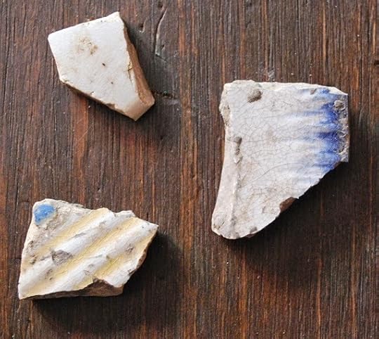 Artifacts I found at Bisland site.
The largest is about the size of a quarter.
(Photograph by author)
All I found were two decorated ceramic shards, nineteenth-century in appearance. Well, perhaps they had been part of an officer’s mess? Perhaps.
Keith and I set out on the seventh stage of our journey down Bayou Teche on November 3, 2012, at 9:40 a.m., starting from where we left off last time just south of Franklin. The morning temperature was 57 °F; the afternoon temperature, a balmy 84 °F.
 Aerial photograph of stage 7,
Far side of Franklin to Calumet.
(Click to enlarge)
(Source: Google Maps)
We shortly spotted a narrow channel running west from the Teche — the Hanson Canal and Lock (29.77261, -91.483286), "[b]uilt in 1907 by the Hanson Lumber Company," according to research by the American Canal Society, "to float log booms from the delta into Bayou Teche." (By "the delta" I assume the ACS meant that of the nearby Atchafalaya River.) In 1922 Hanson Lumber Company sold the lock to the U.S. government, which entrusted its operation to the Army Corps of Engineers. In 1959 the federal government abandoned the lock, which now sits frozen in the "open" position as a vestige of the Teche region's once prosperous but now extinct logging industry.
By 10 a.m. the sun reflected blindingly off the water. We paddled past suburban homes on the west bank, forest on the east. A glance at an aerial photograph, however, revealed that just beyond that wildwood lay enormous swathes of sugarcane. It was already the beginning of harvest and that cane would shortly be cut and ground, its extract boiled and reboiled and processed into raw granulated sugar.
 Fishing camp on the Teche that day.
(Photograph by author)
An increasing number of suburban homes on the west bank meant we approached Garden City (29.765279, -91.465889), a community of several dozen houses and a few industrial buildings. Like Franklin, Garden City makes a short appearance in the classic counterculture movie Easy Rider. By "short" I mean three seconds. Those three seconds show an American flag hanging from a whitewashed, wood-framed U.S. Post Office. Although no longer a public building, the structure still stands, with an American flag hanging from the exact same spot as shown in the movie. This flag went up not too long ago, and if I had to guess I'd say the building's current owner hung it there as a paean to Easy Rider.
 The old boiler.
(Photograph by author)
Around 10:20 a.m. Keith and I reached Frances Plantation, whose Creole-style "big house," built around 1810, stands on the west bank. In the bayou almost directly across from the house Keith and I spotted a rusty iron boiler (29.767817, -91.463067) half sunken amid a stand of cord grass. Paddling over to the artifact, we eyeballed it at about four feet in diameter and about twelve feet in length. Although it could have originated in a sugarhouse, we believe it came from a steamboat — and that the spot on which it sat encompassed the wreck of a steamboat. We came to this conclusion because several pairs of large iron bolts protruded from the Teche, running in tandem from the boiler toward a few sheets of corroded iron several yards away. A metal cable rested atop these sheets like a dark sunning snake. Using our canoe as a yardstick, Keith and I measured this chain of presumably related artifacts — the boiler, the pairs of bolts, the sheets of metal, the cable — and altogether they extended about 85 feet along the waterway: the length of a modest-sized steamboat.
 Sheets of corroded iron near boiler.
(Photograph by author)
Later I queried local history enthusiasts about these artifacts and checked inventories of known sunken vessels on the bayou. No one knew anything about them, nor did they appear on the 1870 survey of the Teche, even though it noted every visible obstruction on the bayou (down to individual stumps and logs). This suggested the boiler and other artifacts date to after the 1870 survey. Regardless, the identity of this steamboat — if that’s indeed what it is — remains a mystery.
 Frances Plantation from the bayou.
(Photograph by author)
After documenting these artifacts, Keith and I paddled farther down the Teche and soon reached Centerville (29.75987, -91.428401) and right beyond it the community of Verdunville (29.75402, -91.401114). Suburban houses stood on both banks. Here we spotted many scattered juglines using cabbage-sized Styrofoam balls as "bobbers." We soon caught up with a motorboater checking these lines; he proudly informed us he’d caught 20 blue catfish so far that day.
 Juglines on the Teche that day.
(Photograph by author)
After a short distance Keith noticed the western side of the bayou had become very shallow. Sticking his paddle into the hazy water, he touched bottom only about a foot below the surface. Spindly bamboo poles rose from the Teche along this stretch, apparently outlining the shoal for unfamiliar boaters. Aerial photographs indicate that when the bayou is low this shoal becomes a lengthy batture(which, as I mentioned previously, refers to marshy land between the water’s edge and the bank of the bayou).
 Bamboo poles marking the shoals.
(Photograph by author)
We soon noticed shoals on both sides of the Teche and, sprouting from the shoals’ slimy mud, fingers of aquatic plants twisting in the current like seaweed.
 The Teche around Verdunville when low.
Note the batture takes up nearly half the riverbed in this image.
When we canoed it, about a foot of water covered this batture.
(Photograph by author)
Around noon we passed the mouth of the Verdunville Canal (29.756218, -91.398575), which runs northeast a short distance to the Atchafalaya Basin Levee. Within sight of the canal the Teche dips southward toward Ricohoc and Calumet, clusters of houses taking their names from local sugar plantations.
About 1 pm Keith and I steered left at a fork in the bayou (29.705574, -91.378969), paddled our canoe through the open west flood gate, and entered the wide expanse of the Wax Lake Outlet.
 The fork in the bayou.
(Photograph by author)
Located directly between Ricohoc and Calumet, Wax Lake Outlet (29.701511, -91.372482), sometimes also called the Calumet Cut, is a massive man-made channel. Completed in the early 1940s by the Army Corps of Engineers, the Outlet runs about sixteen miles in length and stretches roughly six hundred feet in width. It was designed to spare Morgan City from floods by diverting water from the Atchafalaya River to the nearby Gulf of Mexico. The Corps drove the Outlet across the path of the Teche and, unfortunately, through the remains of the Civil War redoubt known as Camp Bisland (located as best I can tell around 29.700355,-91.373905) — thus demonstrating the need for environmental impact studies. (If by chance the the Outlet did not plow right through the fort, the ruin nonetheless would have ended up buried beneath the monumental levee that shadows the Outlet.)
 Battle of Bisland (approximate locations):
1) Fort Bisland;
2) smaller redoubt (connected to fort by trench);
3) Confederate forward entrenchments.
Blue line shows original course of Teche.
Union attacked from northeast following bayou.
(Click to enlarge)
(Source: Google Maps)
The Corps also diverted about a one-mile stretch of the Teche, damming up the bayou’s natural bend at Ricohoc/Calumet and replacing it with a straight detour through two modern flood gates. (I have been educated about these structures by a venerable boat builder of the region: they are not locks, as I initially took to calling them, because they have no chambers in which to raise and lower the water level; rather, they are flood gates, which close when swelling water in the Outlet threatens to deluge the Teche.)
 West flood gate on the Teche at Wax Lake Outlet.
(Photograph by author)
The Louisiana Highway Department had previously run Highway 90 through the same narrow neck of high land — the natural Teche Ridge — so that today the Outlet, detour, flood gates, and highway (as well as a preexisting railroad) all nearly come together at a single point. It had to be this way, because except for this ridge the entire area is flood-prone cypress swamp. This is why the Confederates erected Fort Bisland on this spot: it presented an easily defendable bottleneck along the course of the Teche.
 Looking up the Wax Lake Outlet
as we paddled across it.
(Photograph by author)
After the narrowness of the Teche, the Wax Lake Outlet seemed vast like the Mississippi River. Yet we could see on the opposite bank, not too far ahead, the open east flood gate and, beyond it, the continuing path of the Teche.
This crossing had worried me for months. As I noted in a previous entry, the Outlet’s current could be treacherous. In fact, the annual Tour du Teche canoe, kayak, and pirogue race posts "safety boats" in the Outlet in case contestants run into trouble — the only place it does so for the entire 135-mile course. Race officials also permit contestants to opt out of crossing the Outlet, without penalty, should they find the passage too dangerous. As a local newspaper reported, "Wax Lake Outlet is the most daunting single obstacle in the Tour. . . . With a sometimes raging current, [it] is nothing to trifle with."
Fortunately, the Outlet was subdued that day, and Keith and I cruised across it as though it didn’t even exist. We encountered turbulence only around the two flood gates, where the waters of the Teche and the Outlet converged. There we saw roiling eddies and little whirlpools that swirled into and out of existence. Making strong, deliberate strokes, we paddled through these eruptions and shortly glided into smoother water.
 On the Teche again,
beyond the east flood gate.
(Photograph by author)
Again we came to a fork (29.701026, -91.364292). The right, we knew, was the old channel, now a dead end; the left, however, led farther down the Teche. We steered the latter course and looked for a place to stop for the day. Keith and I had planned to stop at the east floodgate — but we unexpectedly found the banks fenced off by the parish and federal governments. So instead we plowed through a mass of reeds and hyacinths to stop at an empty lot next to a house on the east bank. Beyond the lot and house ran Highway 182, which led back to our homes far up the Teche.
We covered a little more than 10.75 miles that day in about 3.75 hours.
While Keith unloaded our supplies I walked to the house to ask if we could cross the lot to reach the highway.
Permission granted.
As I returned to the canoe I did something I would later regret: using my cell phone I photographed a "For Sale" sign in front of the house. It gave the homeowner’s phone number, which I would need in order to ask permission to start our next and final leg from same adjoining lot. (More about this later.)
Keith and I awaited our ride on the side of the road at Calumet, our backs to the bayou. To our front stood a wide plain covered entirely in stalks of ripe sugarcane.
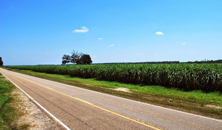 Site of the Battle of Bisland,
Calumet, Louisiana.
(Photograph by author)
We were, however, in the middle of the Fort Bisland battleground (approximately 29.702517, -91.350302). The fort, as I mentioned, had been destroyed by the digging of the Wax Lake Outlet — yet most of the fighting had actually occurred about a mile east of the stronghold. Right where we stood. If Keith and I had materialized at that exact spot 149 years earlier, we would have been blown away by shell, shot, and minie balls fired by either combatant. Despite the Outlet, the highway, and the other modern improvements at Ricohoc/Calument, the battlefield proper remains, now as then, planted in cane, and would have looked much the same to the soldiers in the furrows and trenches as it did to us.
How many scattered bones had we paddled over, I wondered? How many shell fragments and cannon balls and railroad iron blasted from lumbering field pieces or from the gunboats Diana and Cotton?
It is well-known among local Civil War buffs that this cane field, like those upstream at Irish Bend, has yielded countless relics over the generations: buttons, belt buckles, coins, an array of projectiles. A few months ago, while driving this same stretch of highway, I spotted a construction crew excavating a large hole on the battlefield's edge. I stopped and audaciously asked the hard-hatted workers if I might examine the spoil. Sure, go ahead, they said, knocking off for lunch and leaving me alone to poke around in the newly exhumed dirt. Surely I would find some artifacts, I thought — a cannonball or a shell fragment, or maybe a cache of unspent bullets.
 Artifacts I found at Bisland site.
The largest is about the size of a quarter.
(Photograph by author)
All I found were two decorated ceramic shards, nineteenth-century in appearance. Well, perhaps they had been part of an officer’s mess? Perhaps.
April 12, 2014
Welcome to Bayou Teche Dispatches. . . .
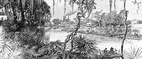
Bayou Teche Dispatches is a collection of my writings about south Louisiana history and culture. Often it consists of material I could not use in my books for one reason or another, but which I nonetheless found fascinating. I hope you enjoy reading these articles as much as I enjoyed researching and writing them.
If you publish information from them, however, please remember to cite this blog as your source and, if applicable, to supply a return link. Please do not repost articles in their entireties, but short block quotations that fall within range of "fair usage" are acceptable.~ Shane K. Bernard
Table of Contents
❧ Sur le Teche: Exploring the Bayou by Canoe, Stage 1
Port Barre to Arnaudville
❧ Sur le Teche: Exploring the Bayou by Canoe, Stage 2
Arnaudville to Parks
❧ Sur le Teche: Exploring the Bayou by Canoe, Stage 3
Parks to Loreauville
❧ Sur le Teche: Exploring the Bayou by Canoe, Stage 4
Loreauville to Jeanerette
❧ Sur Le Teche: Exploring the Bayou by Canoe, Stage 5
Jeanerette to Baldwin
❧ Sur Le Teche: Exploring the Bayou by Canoe, Stage 6
Baldwin to Franklin
❧ Rough Rider Redux: A Photo of Theodore Roosevelt in Downtown New Iberia?
A forgotten photo of Theodore Roosevelt in Cajun Country
❧ A Fiction Interlude: My Short Story "The Phrenologist"
A short story about racism set in antebellum New Orleans
❧ A Floating Dancehall on the Teche: The Club Sho Boat
A riverboat that became a nightclub and restaurant
❧ A Meteor over Cajun Louisiana: Window on Atomic-Age Anxieties
Confusing a meteor for an atomic bomb
❧ A Film Documents South Louisiana's Logging Industry, ca. 1925: Responsible Stewardship or Environmental Disaster?
Digitized film about cypress logging along the Teche
❧ A Glimpse from 1968: Historic Films Looked at Cajuns and Creoles in Epic Year
Digitized French films capture an important year in south Louisiana history
❧ Now Available: My Children's History of the Cajuns in English and French Editions
Buy my Cajun book for kids so I can pay off my credit card
❧ "Cajuns of the Teche": Bad History, Wartime Propaganda, or Both?
A 1942 film with excellent images, horrible script,
❧ A Snake, a Worm, and a Dead End: In Search of the Meaning of "Teche"
Searching for the meaning of the word "Teche"
❧ Galaxies, Bowling and Swamp Pop: Johnny Preston and The Cajuns in Escondido
Examining a Cajun reference in a chain e-mail about old gas stations
❧ Serendipity and Fort Tombecbe: Cooperation between Historians and Archaeologists
Accidentally finding a map of a fort coincidentally excavated by my friend
❧ Notes on Two Nineteenth-Century Engravings of South Louisiana Scenes
Vintage magazine images of Cajun and Creole women
❧ Finding History Right around the Corner: Heroism on the Cajun Home Front
A nearly forgotten World War II landmark a block from my residence
❧ My Father's Childhood Autograph Book on the History Channel?
When Dad met Hank Williams, Sr.
❧ My Oddball Collection of Cajun Warplane Photos
Cajun-themed combat aircraft
❧ Elodie's Gift: A Family Photographic Mystery
An old tin type image given to me by a great-aunt
❧ A rocket named "the Cajun"?
❧ Perpetuation of a historical error
❧ Debunking the Alleged Origin of the Word "Coonass"
Finding a word by accident that wasn't yet supposed to exist
❧ More on That Word "Coonass": A Labor Dispute Trial Documents Its Use in 1940
The earliest known use of this controversial word
❧ "To Err Is Human": Errata from My Books
Everyone makes mistakes
❧ An Old Bull Durham Tobacco Ad in New Iberia, or Palimpsests on the Teche
This vintage advertisement has since been destroyed
❧ Remembering Polycarp: A Cajun TV Show Host for Children
Everyone loved Polycarp!
❧ From Jet Fighters to Football: Origin of the Phrase "Ragin' Cajun"
Where this catchy term originated (as far as anyone knows)
❧ The Elusive André Massé, Pioneer of the Attakapas
An almost mythical explorer of the Teche region
❧ More on the Elusive Andre Massé, Early Settler of the Attakapas District
Revelations about him in a historical document
❧ La Chute: A Waterfall on Bayou Teche?
A waterfall in largely flat south Louisiana
❧ Gumbo in 1764?
The earliest known reference to gumbo in Louisiana
❧ On That Word "Gumbo": Okra, Sassafras, and Baudry's Reports from 1802-1803
More on the history of gumbo in Louisiana
❧ La Pointe de Repos — Early Acadian Settlement Site along the Teche
Colonial-era settlement near present-day Parks, Louisiana
❧ A 1795 Journey up the Teche: Fact, Fiction, or Literary Hoax?
It almost fooled me . . . almost
❧ All the Same Place: Isla Cuarin, Côte de Coiron, Île Petite Anse, Petite Anse Island & Avery Island
Evolution of a place name in the south Louisiana coastal marsh
❧ The Grevembergs, Early Cattle Ranchers of the Attakapas
When someone accidentally transposes two numerals
❧ Tracking the Decline of Cajun French
Research behind the language stats in my book The Cajuns
❧ The Secret CODOFIL Papers
I waited how long for the FBI to release these documents?
❧ Agnus Dei Artifact Found on Banks of Bayou Teche
A religious symbol turns up in the mud at Breaux Bridge