Sam Benson's Blog
June 4, 2014
Harmony Headlands State Park: Go Now
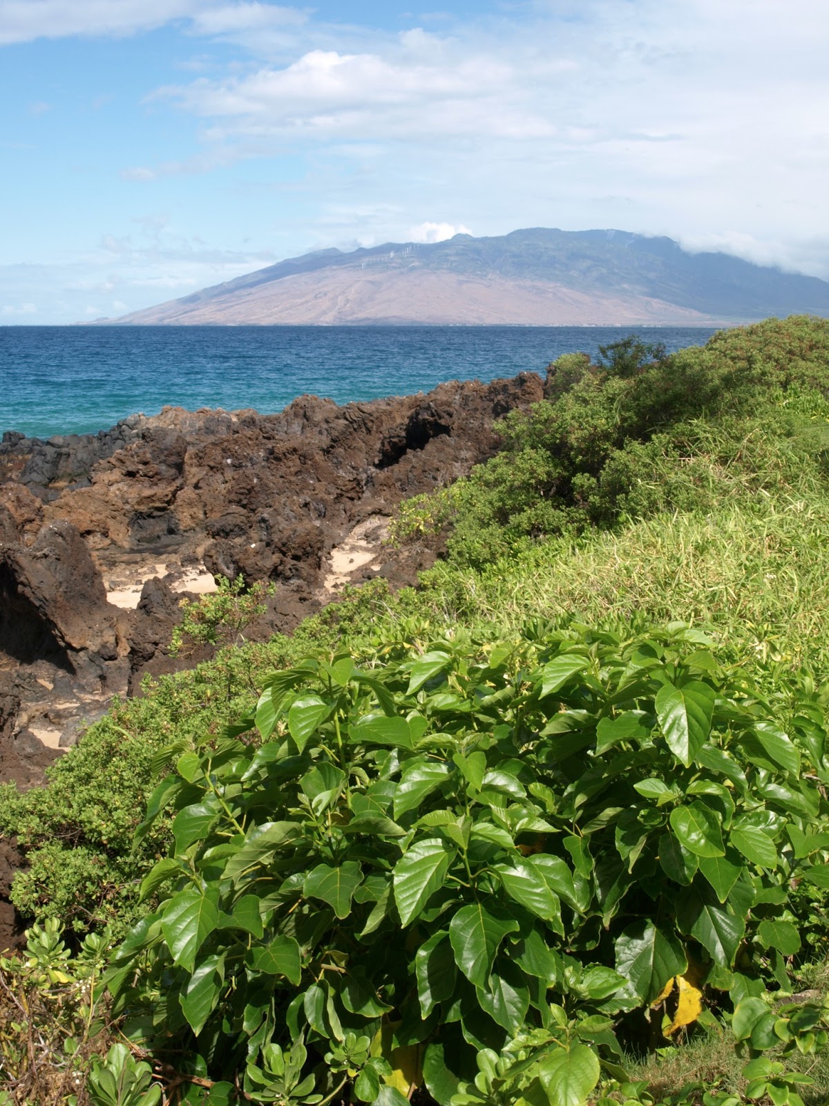
.JPG) With over 275 California state parks to choose from, sometimes it's the littlest parks that get overlooked. Honestly, that's OK with me, because it means more solitude when I hike. But low visitation numbers also equal a greater chance of that park being closed next time California has a budget crisis. That's why I'm devoting this entire post to showing you the giant beauty of tiny Harmony Headlands State Park. If enough of you get out there and go visit this park, it'll still be there for decades to come.
With over 275 California state parks to choose from, sometimes it's the littlest parks that get overlooked. Honestly, that's OK with me, because it means more solitude when I hike. But low visitation numbers also equal a greater chance of that park being closed next time California has a budget crisis. That's why I'm devoting this entire post to showing you the giant beauty of tiny Harmony Headlands State Park. If enough of you get out there and go visit this park, it'll still be there for decades to come..JPG) Harmony Headlands is the second-youngest California state park currently open to the public (only Fort Ord Dunes State Park on Monterey Bay opened more recently). At Harmony Headlands, you'll have a 4.5-mile round-trip hiking trail [map PDF] to the coast, across gently rolling former cattle and dairy ranch lands, almost to yourself, even on sunny summer weekends. Where Chumash tribespeople once camped and Chinese immigrants harvested kelp to send to San Francisco, today a wild beach remains unblighted by development. Sea otters and seals splash in the tidal waters, while brown pelicans soar on the winds. Black-bellied salamanders skitter and California king snakes slither along the trail beside grasslands.
Harmony Headlands is the second-youngest California state park currently open to the public (only Fort Ord Dunes State Park on Monterey Bay opened more recently). At Harmony Headlands, you'll have a 4.5-mile round-trip hiking trail [map PDF] to the coast, across gently rolling former cattle and dairy ranch lands, almost to yourself, even on sunny summer weekends. Where Chumash tribespeople once camped and Chinese immigrants harvested kelp to send to San Francisco, today a wild beach remains unblighted by development. Sea otters and seals splash in the tidal waters, while brown pelicans soar on the winds. Black-bellied salamanders skitter and California king snakes slither along the trail beside grasslands.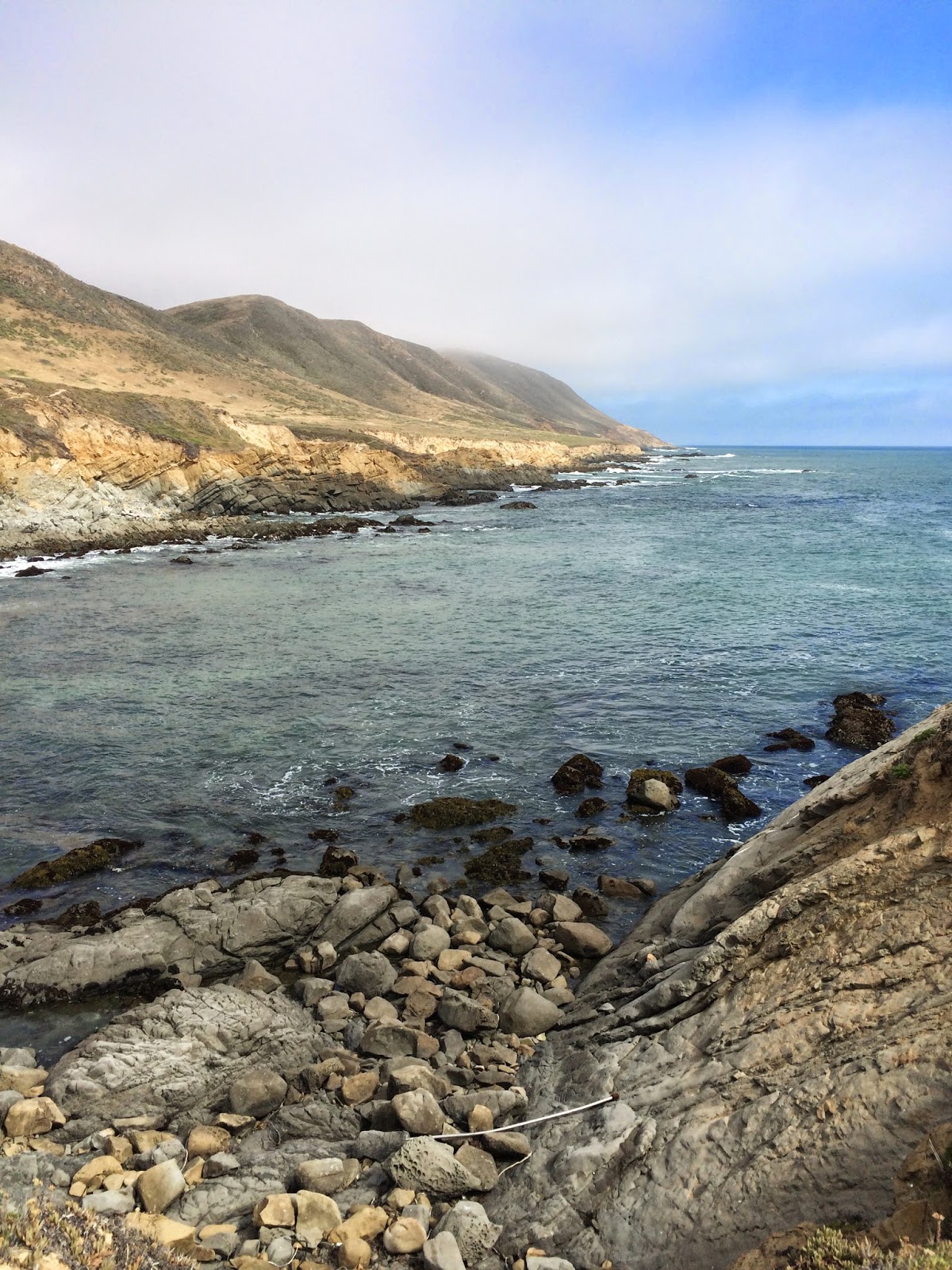 To find this park, look for the Hwy 1 pull-off marked by a brown 'Coastal Access' sign pointing toward the ocean. There's only enough room in the parking lot for 10 cars, so you might have to park in a wide-open gravel turn-out immediately north, on the same (side of Hwy 1. The park is open from 6 a.m. until sunset daily. A day-use parking fee of $3 per car will eventually be charged, but it's free right now.
Harmony Headlands State Park is less than 3 miles south of Harmony (population 18), California's smallest town. Harmony is overshadowed by grandiose Hearst Castle, lording over California's Central Coast from a hilltop about 20 miles farther north up Hwy 1. The town is kept alive by artists' workshops and galleries. Inside a 19th-century creamery building are a historical post office, which townspeople keep trying to re-open, and a charmingly rustic Harmony Cafe run by an Italian expat - stop for espresso and homemade tiramisu.
.JPG)
What's your favorite California state park, big or small? Tell us by leaving a comment below.
Want more stories and travel advice like this?
Coastal California: The Anti-Hotel Top 10 List
Lovelorn Elephant Seals at Piedras Blancas
10 Steps to a Perfect Day in Big Sur
Photos: Harmony Headlands State Park (Sara J. Benson) & Harmony, CA (Jonathan J. Hayes)


November 5, 2013
Three Places to Reclaim Wildness on Hawaii's Big Island
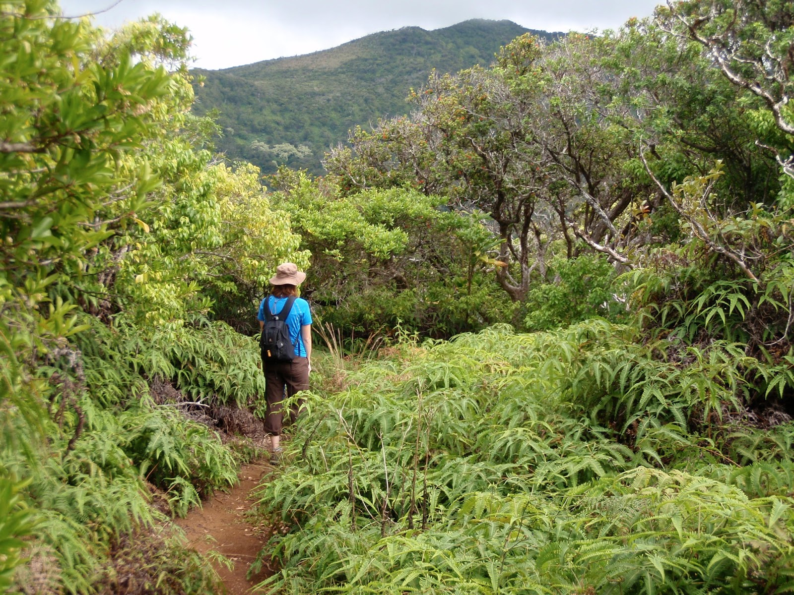
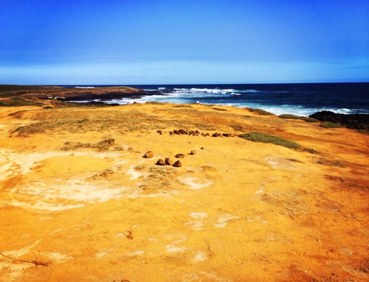 Of all the Hawaiian Islands, the Big Island is the only one whose adventures I never completely exhaust, not even when I lived there. But like on Oahu, Maui and Kauai, the tides of tourist development seem impossible to turn back or even slow down. That's why it made me overjoyed recently to find both old and new spots on the Big Island where wildness still rules. Here's how you can visit them yourself while practicing malama aina (love, respect and care for the land), a Native Hawaiian cultural tradition.
In the jet-black lava rock desert of the Kau district, Ka Lae (check out my Instagram photo, above) is the southernmost point in the USA. It's said that the first Polynesian voyagers to reach Hawaii landed their canoes here, and for centuries afterward, return trips to Tahiti often launched from this sacred ground. Today you can drive here via local ranch lands (my travel companion couldn't resist pointing out "The southernmost cows in the USA!") and a high-tech wind farm. Park your car at the end of the rutted dirt road, then walk out to the ancient point, flayed by strong winds and high surf that crashes chaotically into the rocky shoreline. There's not a resort hotel or tiki bar in sight, I promise.
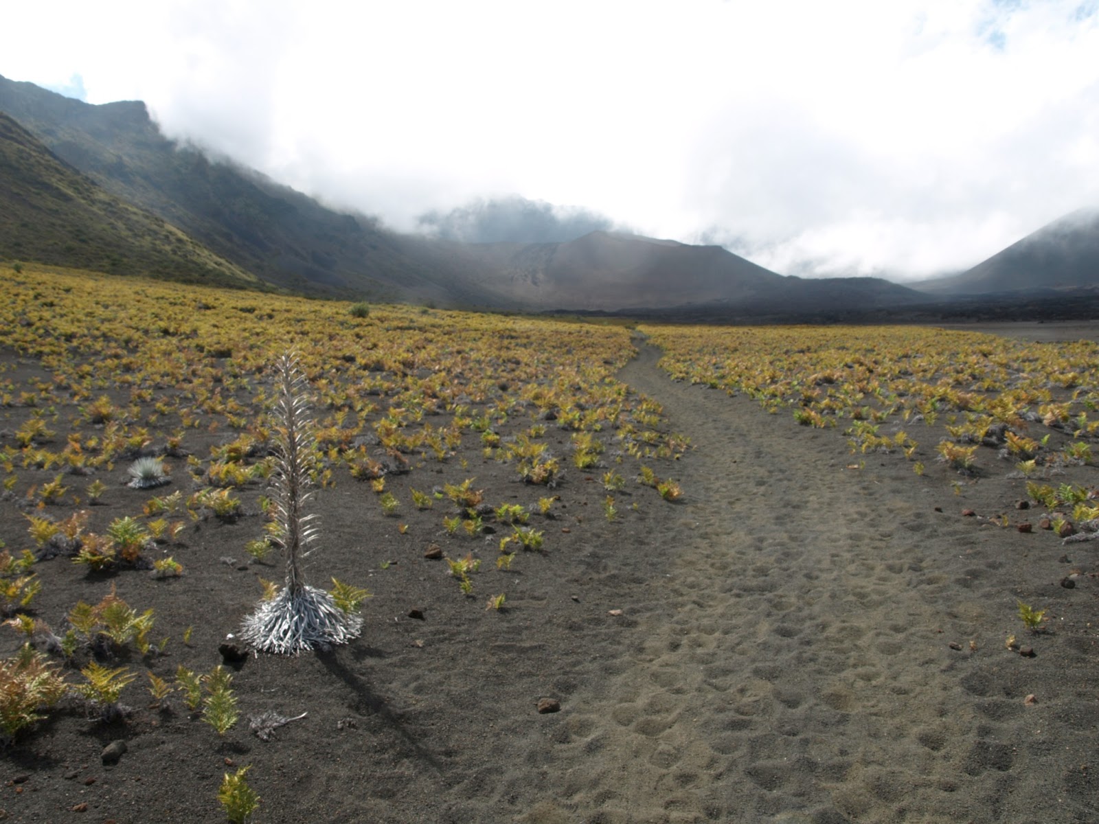
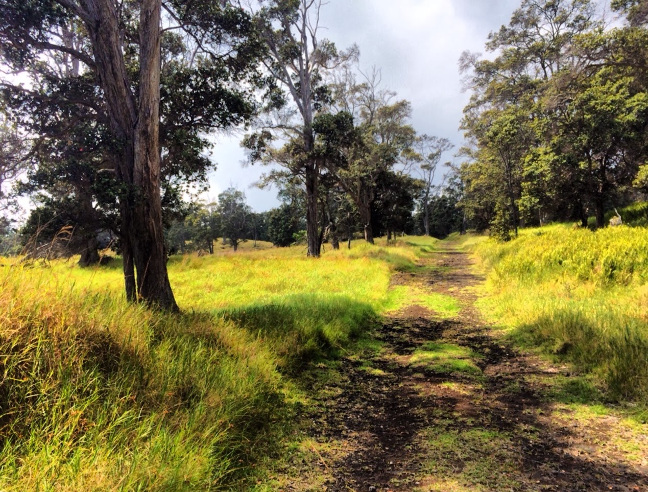 Less than an hour's drive away is the Kahuku Unit wilderness addition to Hawaii Volcanoes National Park. Although the park has owned this historic ranch since 2003, the unit has only been open on a limited basis to the public for the past few years. Across tranquil pasture land, through native forest and atop lava flows on the slopes of Mauna Loa volcano, several hikes let you escape the crowds over on North Kona and South Kohala beaches. Most varied of all, the Puu o Lokuana Trail barrels over an abandoned airstrip and climbs a cinder cone for views over dramatic lava all the way to the Pacific. The Kahuku Unit gates are currently only open between 9am and 3pm on Saturday and Sunday. Helpful rangers and volunteers at the entrance hand out hiking maps and give valuable tips and advice.
 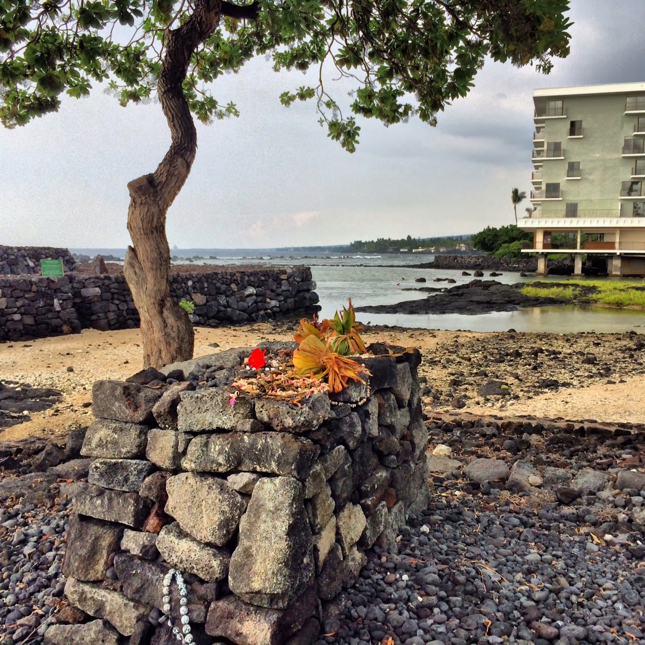 As a travel writer, I've rarely witnessed hotels being torn down, only built up (except for casino implosions in Las Vegas). Never before have I heard of a resort in Hawaii being demolished to make way for the restoration of ancient temples and cultural sites. But that's exactly what is supposed to happen in Keauhou, south of Kailua-Kona. The Outrigger resort hotel here has closed and may be demolished as soon as 2015. Sponsored by Kamehameha Schools, Hawaiian heiau (temples) have already been restored, and plans call for building an outdoor education complex and community cultural center. In the interim, you can still visit these sacred Hawaiian sites by asking permission at the security guard shack. When I was there alone last week, hookupu (offering bundles) already lay atop the lava-rock altar and ancient Hawaiian petroglyphs were peeking out at low tide along the beach.
Where are your favorite wild spots in Hawaii? Tell everyone by leaving a comment below. Mahalo!
Want more travel stories & advice? Click below.
Tips for Epic One-Way Hikes in Hawaii
Maui's Best Walks for Wildlife Watching
I Am a Park Ranger: Video from Behind the Federal Shutdown's Locked NPS Gates
Photo credits: Big Island of Hawaii (Sara J. Benson)
October 16, 2013
I Am a Park Ranger: Video from Behind the Federal Shutdown's Locked NPS Gates
During the federal government shutdown, I've been frustrated by those US citizens who say that it's their right to trespass on national park lands that are currently closed. Cloaked in blustery self-righteous indignation, many of these trespassers are doing nothing more than throwing a childish tantrum, because they can't get what they want. They're missing the bigger picture: how can we all help preserve national parklands during political crises?
Instead of respecting the natural and cultural resources that our national parks and dedicated ranger staff work to protect, thoughtless trespassers have trampled fragile ecosystems, broken visitor infrastructure, defecated next to locked bathrooms, and even hurt themselves and required rescue by park staff who are already stretched to their limits, first by budget cutbacks and then by the shutdown.
Nobody can explain this better than national park rangers themselves, which is why you should watch the heartbreaking video above, put together by the National Parks Conservation Association. It's my hope that people will stop defaming and challenging park rangers just for doing their job, protecting national parks. Instead we should place blame for park closures where it belongs: on the US Congress.
If your national parks vacation has been ruined by temporary national park closures, feel free to post a comment below asking for trip re-planning advice and the best alternative places - hello, state parks! - that you can still visit during the shutdown.
Related links:
National Parks Conservation Association: Government Shutdown Closes National Parks
US National Parks: The 4 Biggest Advantages of Autumn Travel
Visiting Yosemite National Park? 5 Tips to Avoid Being Driven Mad by Crowds
September 28, 2013
Travel Amulets & Risks on the Road
.JPG) Traveling is always a risk. My doctor told me after I ended up in the ER in Montana last week, "You live life on the edge." That isn't true, however, or at least it doesn't feel true to me. I've been to 30 countries and six continents, but many people I know have traveled far more. I don't base jump off skyscrapers, or ride motorcycles into remote jungles. I don't even hitchhike (much) anymore.
Traveling is always a risk. My doctor told me after I ended up in the ER in Montana last week, "You live life on the edge." That isn't true, however, or at least it doesn't feel true to me. I've been to 30 countries and six continents, but many people I know have traveled far more. I don't base jump off skyscrapers, or ride motorcycles into remote jungles. I don't even hitchhike (much) anymore. I do travel cheaply, which inevitably means taking more chances than an average traveler: on a dingy hotel in Bangladesh with a sketchy night manager and sleazy pinholes in the wall; on an overloaded flight out of Laos on a retired Russian helicopter; or camping in the Rocky Mountains when the temperatures are below freezing at night and I wake up with frost on my sleeping bag and my nose.
Sometimes I've encountered bad luck and violence as a solo woman traveler. A Chinese soldier once pulled me off a bus and held me at gunpoint while his comrade emptied my backpack. A Malaysian man on a motorbike groped and tried to assault me while I was cycling, until I started throwing rocks at him. On a ship bound for Patagonia, I experienced a traumatic brain injury that has left me with permanent neural deficits and a disability.
But I've also had very good luck on the road, with strangers generously showing me love and embracing hospitality. After I was bit by a rabid dog on a remote Indonesian island, half the the village adopted me for six weeks as I recuperated. In Korea, a family I met on the ferry over from Japan took me home with them, electing themselves my hosts and guides around the country for a week. In Ireland, I always got a lift from locals (except priests, who seemed to never stop for hitchhikers), even over the border with Northern Ireland during troubled times.
Right now, I'm too sick to travel and am waiting on biopsy results for a definitive diagnosis of what's wrong with me. Whenever I am in the hospital, I always wear a small jade Buddhist amulet that I bought in Bangkok. It hangs on a gold chain that was a gift from a good friend in Malaysia, a man who always gave me safe harbor after ugly things that happened on the road, someone who never expected anything in return, someone who was like an older brother to me. When I wear the amulet, I remember all of the love I've been given around the world that I did nothing to deserve. It keeps me hoping that things will turn out all right, that no matter what the medical diagnosis is, I'll still be able to do the only things I live for: summiting mountains, following deserted roads to the horizon's edge and escaping to far places nobody else I know has ever been.
Photo: Death Valley National Park (Sara J. Benson)
September 25, 2013
Tackling the John Muir Trail: From Yosemite South to Devils Postpile
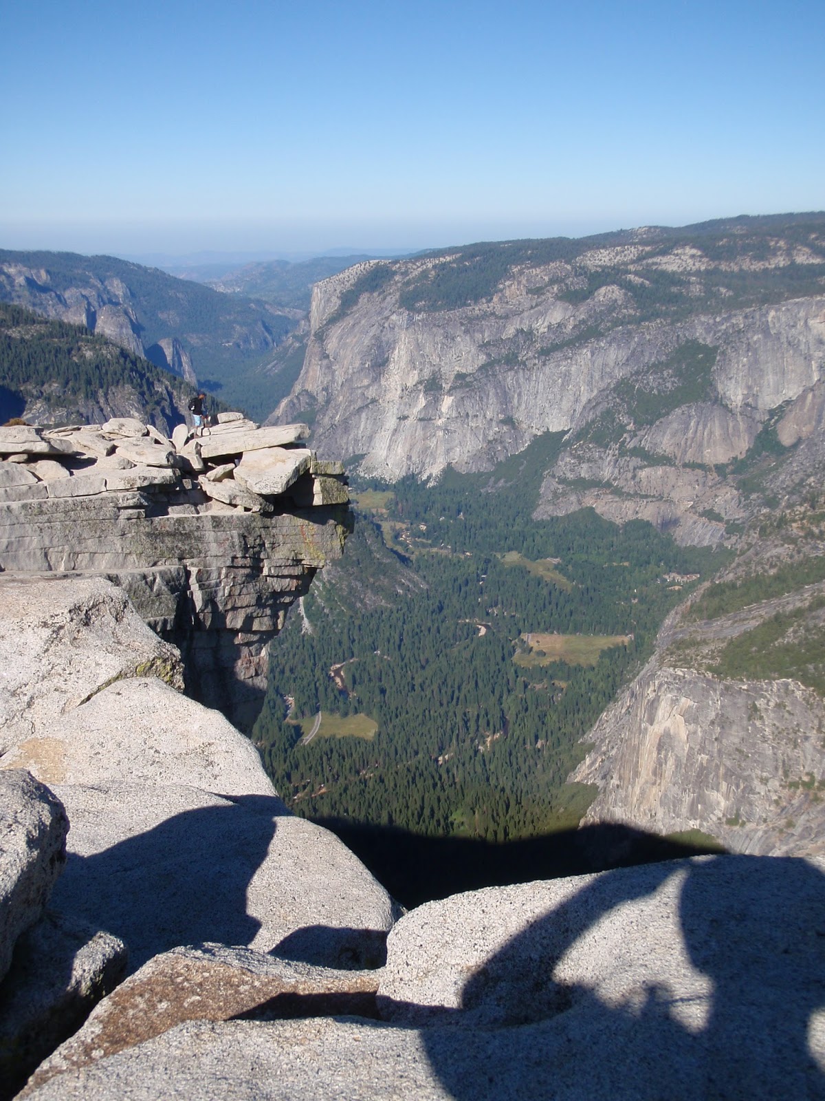
 Inspired by a friend who stood on top of Mt Whitney (14,505ft) last year after section hiking the 215-mile John Muir Trail, I've been gradually knocking off pieces of the JMT. My goal is to summit Mt Whitney by 2015, to see if I can do it post-traumatic brain injury (TBI). Ever since a shipboard accident in South America several years ago, I've been working hard to rebuild my balance, strength, endurance and tolerance for high elevations.
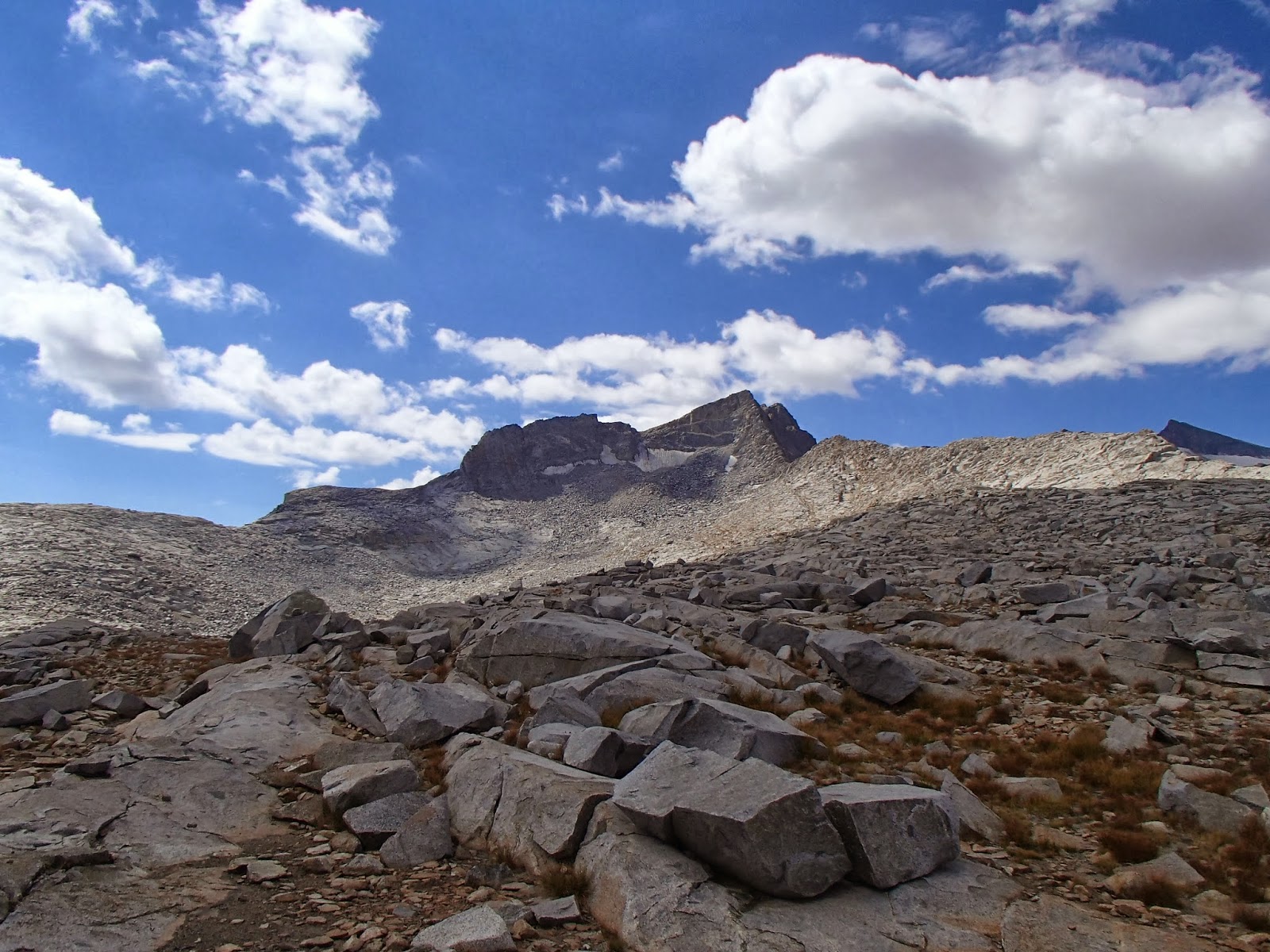
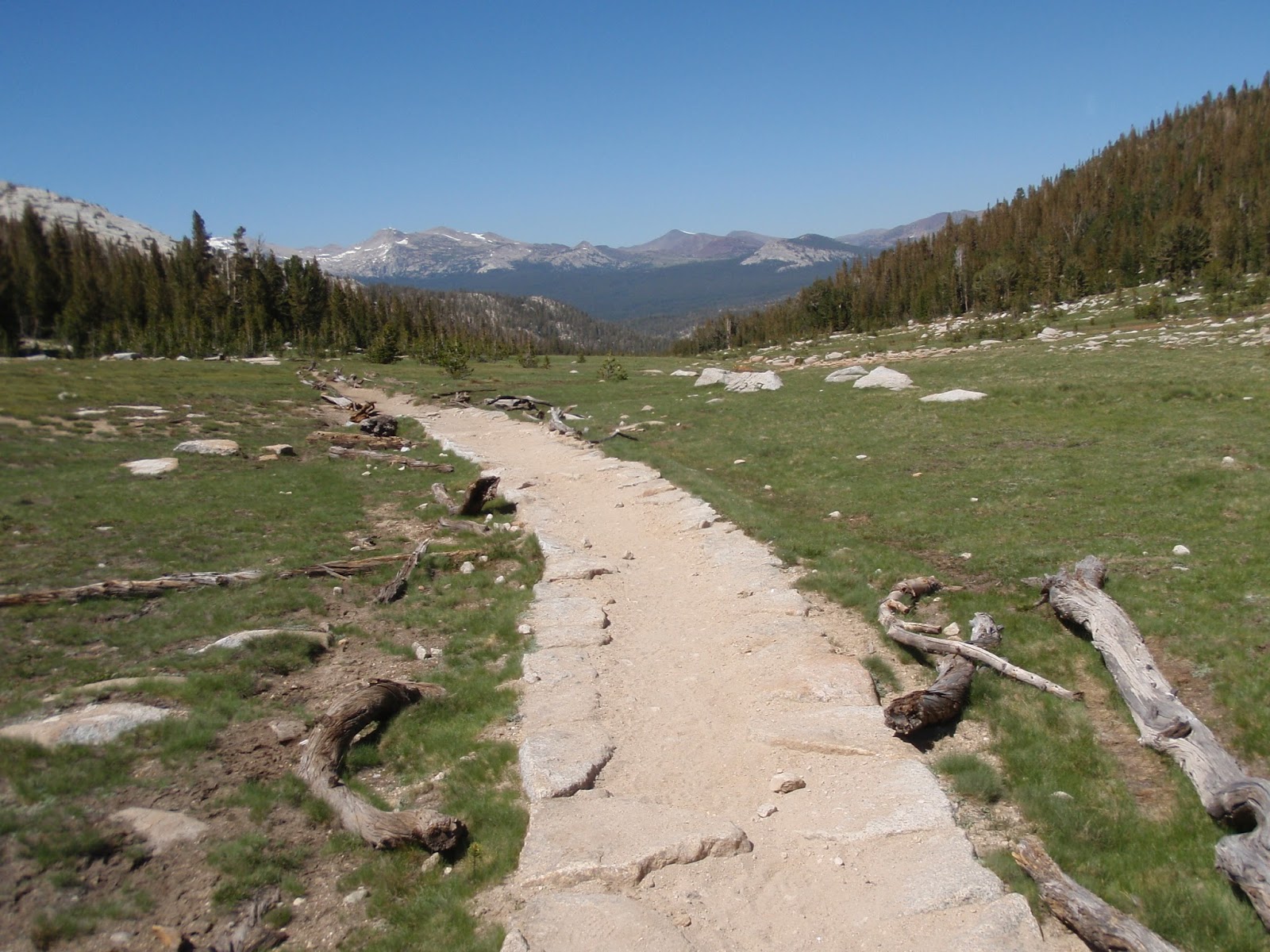
Though hampered by the massive Rim Fire, this year's section hike along the JMT took us 35 miles from Yosemite National Park's Tuolumne Meadows to Devils Postpile National Monument, right outside Mammoth Lakes.
Day 1 is a warm-up day to stretch your legs and flex your backpacking muscles. It's not too difficult of a climb from Tuolumne Meadows up through Lyell Canyon, going approximately 10 miles. Plan on camping near water - either by a stream crossing or beside a small lake - somewhere down below Donahue Pass.
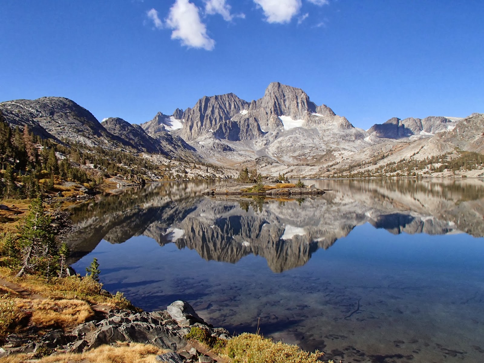
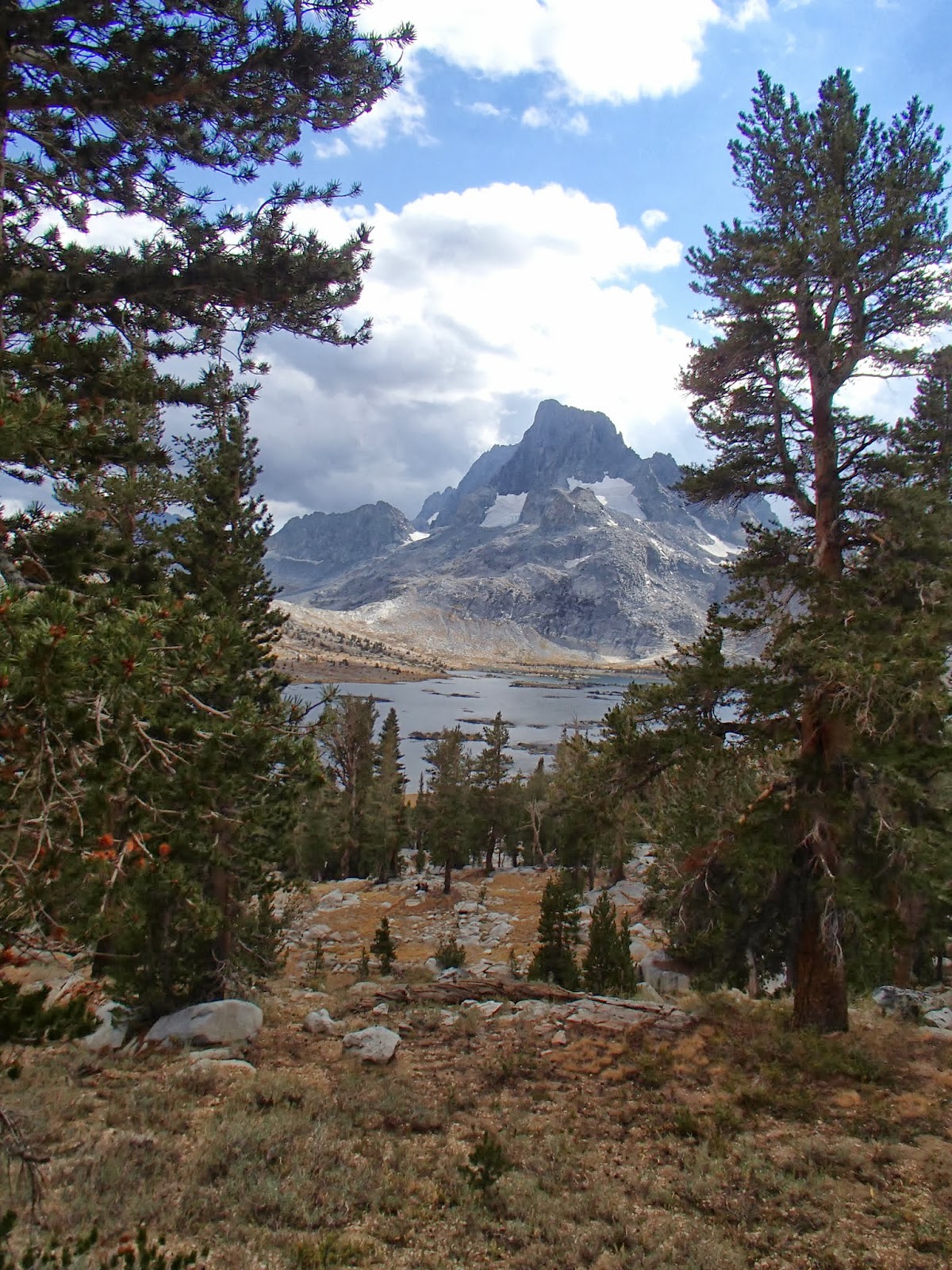 Day 2 is more of a challenge, ascending to Donahue Pass (11,056ft). Surprisingly, there's no marker for the pass - just boundary signs for Yosemite National Park and the Ansel Adams Wilderness. It's a mostly downhill trek to Thousand Island Lake, skipping down through fields of granite rocks, streamside wildflower meadows and pocket lakes. Stopped by a rainstorm after 11 miles, we ended up camping between Thousand Island Lake and Garnet Lake, arguably the most scenic beauties along this section of the JMT.
Day 3 is not easy: 14 miles with thousands of feet of elevation gain and loss. From Garnet Lake, you'll steeply ascend, then drop back down to the Shadow Lake junction with the trail to Agnew Meadows, where suddenly you'll be in the company of shiny-haired day hikers. It's a brutal 600ft climb of about a mile up to Rosalie Lake, followed by a shorter, less steep ascent to Gladys Lake. Soon the trail starts relentlessly switchbacking and tumbling downhill through thick forest without many views. Eventually, you'll pop out near marshy Johnson Lake. You can filter water at the next stream crossing about 15 minues away. From there, it's just a few miles to Devils Postpile.
If you're thinking of doing this route, here are a few practical tips to make your trip easier:
Transportation: Shuttle two cars, leaving one at the overnight (upper) parking area outside Devils Postpile. Otherwise, hike during the Reds Meadow summer shuttle season, when you can ride a bus from Devils Postpile to Mammoth Lakes, then take the YARTS bus from Mammoth Lakes to Tuolumne Meadows. Depending on when you exit the trail, you may need to stay overnight in Mammoth Lakes to catch the YARTS bus to Yosemite the next day.
Trailhead permits: Although it's easier to get an overnight wilderness permit starting from the south in the
 Weather & when to go: For the most accurate weather information for Tuolumne Meadows and
 Bear-resistant canisters: These are required for storing all food, garbage and scented items during wilderness trips in Yosemite and the Ansel Adams Wilderness. Rent a reliable old Garcia model from Yosemite, or invest in your own lighter-weight canister. I carry the Bear Vault 500, which is big enough for two people taking a 4-day trip, if you pack efficiently.
What are your favorite hikes in Yosemite National Park and the Eastern Sierra? Let us know by leaving a comment.
Related links:
Visiting Yosemite National Park? 5 Tips to Avoid Being Driven Mad by Crowds
US National Parks: The 4 Biggest Advantages of Autumn Travel
Fall Travel: Sunshine on California's Coast
Photo credits: Sara J. Benson & Michael Connolly Jr.
August 18, 2013
Tips for Epic One-Way Hikes in Hawaii
 This week, a vacationing hiker asked me about a one-way hike inside Haleakala National Park. A local hiking guide service on Maui had quoted him an outrageously high price of over $2000 for an overnight guided hike with transportation! He wondered if there was a cheaper way to do it.
Some of the wildest, most memorable hikes I've taken in Hawaii have been one-way trails, but transportation was usually a thorny problem. Here are my top tips for solving that pesky issue:
1. Make friends. Nothing beats an island friend who is willing to drop you off at one trailhead and pick you up at another. But this isn't an option for most hikers, especially first-time visitors to Hawaii.
2. Call a taxi. This strategy has never worked for me. But I know hikers who have arranged in advance for a taxi to pick them up at the end of their hike, then drive them back to where they started hiking and parked their rental car. If you ask a tour company or hiking outfitter to do this, they'll usually agree - but it won't be cheap.
3. Hitchhike. While you are always putting yourself at risk by hitchhiking, and I can't personally recommend it (nor can I be held liable for anything that happens if you do try it), it's a fact that many hikers do hitchhike in Hawaii.
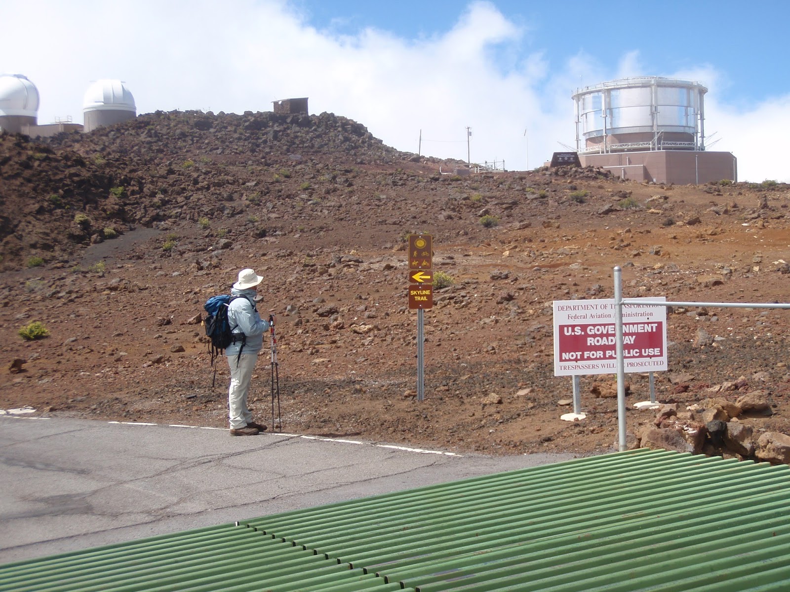
In Haleakala National Park, rangers have signposted a roadside hitchhiking zone near the Halemaumau Trailhead parking lot. It's used by hikers who want to hike one-way down the Sliding Sands Trail and across the volcano, then exit via the Halemaumau Trail. I've used this hitchhiking zone several times, and never waited more than 20 minutes for a lift up the mountain. It helps that I always bring a hand-written sign spelling out "SUMMIT VISITOR CENTER" so drivers know where I'm trying to go.
On the other hand, hitchhiking did not work for me when I hiked from Waianapanapa State Park to Hana Bay, then needed a lift back to my campsite at the state park. I ended up walking several miles along the narrow highway unsafely after dark because no day-tripping tourists were willing to pick me up as they rushed back to Paia from Hana.
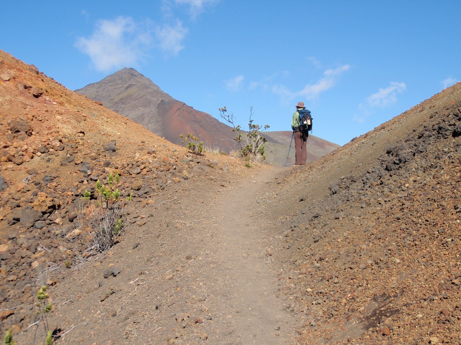
4. Hike halfway, both ways. For some trails, like the Kaupo Gap Trail and Skyline Trail starting in Haleakala National Park, I've ended up hiking twice as far just to experience the entirety of these trails. If you're exiting at Kaupo or inside Polipoli Spring State Recreation Area, it's tough to find someone who will pick you up, even if you offer to pay them, and it's too remote to hitchhike. My solution was to start at the top of each trail, hike halfway down, turn around and hike back up. Then I drove around the island to each exit trailhead, hiked halfway up the trail and back down again. It's more effort than most hikers will want to make, but I did get to hike 100% of both of these beautiful, mostly untrammeled trails, which I comprehensively cover in my hiking guidebook Top Trails Maui: Must-Do Hikes for Everyone.
Do you have suggestions for arranging transportation for one-way hikes on Maui or any of the other Hawaiian Islands? Please share your ideas and tips by posting a comment. Thanks!
Related links:
Do You Need GPS to Hike in Hawaii?
The Best Hike on Maui Is...
Maui's Best Walks for Wildlife Watching
Photo credits: Haleakala National Park (Sara Benson & Michael Connolly Jr.)
July 26, 2013
Visiting Yosemite National Park? 5 Tips to Avoid Being Driven Mad by Crowds
 I've visited Yosemite National Park more times than I can count, always trying to avoid the biggest crowds. It's a cinch to find solitude in a giant sequoia grove blanketed by snow in winter. But what about exploring the park during peak travel times, when waterfalls peak in late spring and during the busy summer season from Memorial Day to Labor Day?
Here's what I've learned after years of getting stuck in Yosemite Valley traffic jams, being turned away from full campgrounds and jostling with marching armies of vacationing families on the park's most popular trails. (It also helps to have worked for two seasons as a national park ranger in the Sierra Nevada, I admit, so get ready for some insider tips.)
1. Don't Drive Anywhere, If You Can Help It
You can visit many areas of the park without ever needing a car, which saves you parking headaches and wasted time in traffic jams. Free shuttles circulate around the valley year-round, and along Tioga Road during summer. YARTS public buses travel Hwy 120 and Hwy 140, linking the valley and high country with the Eastern Sierra and the western Sierra foothills. Amtrak offers train service to Merced, with connecting buses to Yosemite Valley.
To reach Glacier Point, take the fee-based tour bus from Yosemite Valley in summer. Most people don't know about the free summer shuttle between Yosemite Valley and Wawona, although it only runs once daily in each direction and on-board space is very limited. From Wawona, free and frequent seasonal shuttles take you to the Mariposa Grove.
2. Hike In Reverse, or Just Hike Further Away
If you want to hike the Mist Trail up from the valley or traipse around Tuolumne Meadows, there's no escaping the crowds during summer unless you get a crack-of-dawn start. But Yosemite has 750 miles of trails to explore, so why limit yourself to just the easiest, most accessible hikes that everyone else is taking? By going even slightly off the beaten track, or at least by hiking in the opposite direction, you'll get a much more peaceful walk in the woods.
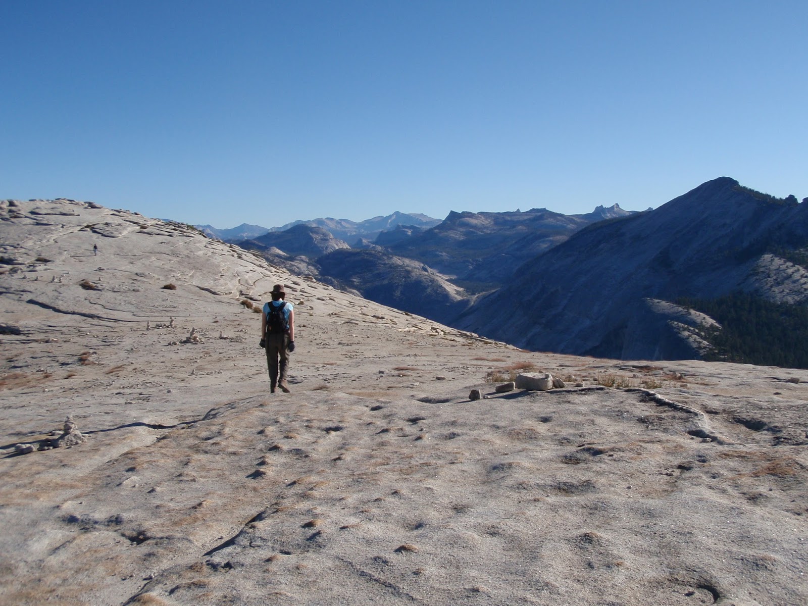
Hike even a mile down the Panorama Trail from Glacier Point and the crowds of shutterbugs just melt away (and you won't encounter nearly as many people as on the famous Four Mile Trail either). Off Tioga Road in the high country, the trail to Gaylor Lakes is only lightly trod, even at the height of summer. Looking to bag Half Dome? Instead of hiking up from the valley in just one day, hike downhill from Tuolumne Meadows via Cloud's Rest or the John Muir Trail on an overnight backpacking trip.
3. If You're Not an Early Bird, Get a Late Start
I love a lot about being outdoors: camping, hiking, backpacking, canoeing, skiing etc. What I don't love is getting up early in the morning. But instead of that being a drawback, it can actually be an advantage when visiting a busy national park like Yosemite. If you start your day at 10 a.m. instead of 8 a.m., you'll be two hours behind the worst crowds all day. While that might prevent you from getting a parking spot right by the trailhead, it can be perfect for finding a no-reservations campsite (as other campers are checking out) or taking a hike with fewer people on your tail. Some of the most relaxed days I've spent outdoors in Yosemite have ended around sunset, after which I've walked into the Mountain Room Restaurant and gotten a table with no waiting.
4. Last-Minute Camping: Be Ready to Rough It
For Yosemite National Park campgrounds that require reservations, you'd better get organized five months in advance. Personally, I'm not all that keen on booking my trip that far out, or camping at noisy, jam-packed campgrounds in the valley. I'd rather take a chance on turning up mid-morning at a first-come, first-served campground and seeing if any sites are available. True, you might have to sacrifice some amenities at these campgrounds or possibly travel on a dirt road to get there, but unless you're visiting on a summer weekend, your chances of finding a spot are pretty good. Otherwise, there's always free, DIY dispersed camping (read: no toilets, drinking water, bear lockers or campfires) on national forest land adjacent to the park.
5. Plan as Much as You Can in Advance
 I'm more of a spontaneous traveler myself. But if you're going to visit Yosemite during the summer, even a little bit of advance planning will go a long way toward making your trip easier and more fun. Book lodging, campsites and Half Dome day-hiking and all wilderness permits several months in advance (or check for last-minute cancellations just before your trip starts). Download a free PDF of the park's seasonal newspaper ahead of time so you can better plan your days around what's going on during your visit. Read up on Yosemite's hiking trails and pick out which ones you want to try before you arrive.
 And here's another way to make sure you don't waste a minute of your next Yosemite trip (shameless self-promotion alert!): buy this Lonely Planet guidebook I co-wrote, called Yosemite, Sequoia & Kings Canyon National Parks, available in print and as an e-book.
Have you got another tip for avoiding crowds in national parks? Share it by posting a comment.
Related links:
US National Parks: 4 Advantages of Autumn Travel
Yosemite's Half Dome Through the Back Door
Hiking Yosemite's Half Dome: Photo Essay
Insta-guide to Kings Canyon National Park
Photo credits: Yosemite National Park (Sara J. Benson & Michael Connolly Jr.)
April 13, 2013
Do You Need GPS to Hike in Hawaii?
 Maybe you've never been hiking before in Hawaii, or perhaps you're planning to tackle a trail for which the latest USGS topo map dates from the 1970s. If so, you might be wondering if a GPS device or smartphone could help you out. On faint footpaths over lava fields marked only by ahu (cairns) or into valleys usually only visited by pig hunters, could GPS save you from getting dangerously lost?
To hike the most popular, easily accessible trails on the main Hawaiian Islands, you don't need GPS. (In fact, you might not even need hiking boots - but the 'rubbah slippah' debate is a subject for another post!) Just pay attention to roadside mile markers to find the trailhead, then follow the all-ages crowd ambling into the ferny forest for a waterfall swim.
Trails managed by the state-wide Na Ala Hele: Hawaii Trails System & Access program are often marked with signs not just at the trailhead, but at key junctions along the way. It'd be difficult to get lost, given how well-trod many trails in Hawaii are. In quite a few places, your smartphone or GPS device won't work anyway, making the point moot.
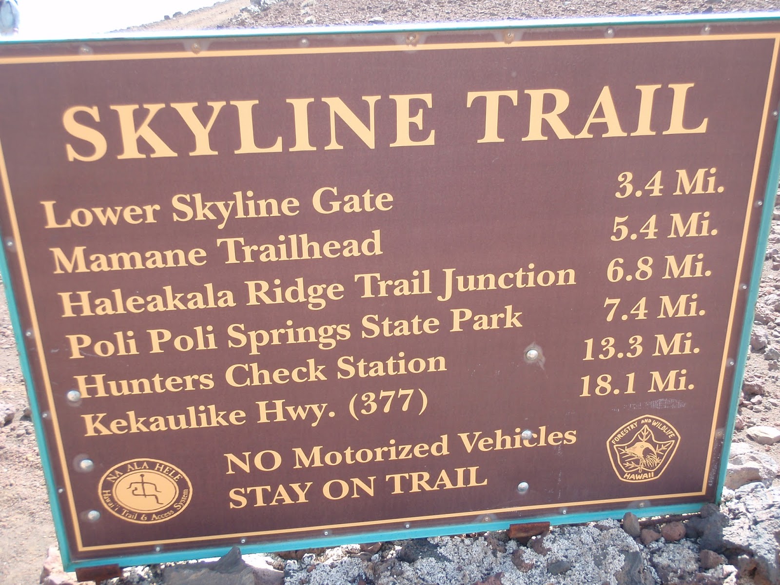
 When I was researching my book Top Trails Maui: Must-Do Hikes for Everyone, I carried a handheld GPS device on every hike. I found it useful for pinpointing exactly where remote or badly signposted trailheads are. I also found it helpful for navigating little-traveled trails, for example, the Kaupo and Skyline Trails [PDF] on the backsides of Haleakala volcano. Both of those trails end in places that feel eerily like the middle of nowhere (respectively, Kaupo town off the remote Piilani Hwy and Polipoli Spring State Recreation Area). It also helped to know how far I'd already hiked and what elevation I was at, to keep from being misled by confusing trails-of-use. Being at such a high elevation on these trails also ensured that the GPS reception remained strong and clear enough.
 I'd used a GPS device before on the summit trail up Mauna Kea, Hawaii's highest peak, and when trekking across lava flows and cinder deserts inside Hawaii Volcanoes National Park, both on the Big Island. On Kauai, GPS prevented me from getting lost on a network of trails inside Kokee and Waimea Canyon State Parks. On Oahu, GPS was essential for trekking overgrown trails to summits in the Koolau Mountains above Honolulu (at that time, Na Ala Hele didn't post Oahu trail maintenance updates on Facebook like they helpfully do now).
 Overall, on 90% of hiking trails in Hawaii, you don't really need GPS. It'll be just another electronic device weighing down your pockets. But if you're planning on doing any wilderness hiking, GPS might be your next best island hiking buddy.
Find out more about Hawaii's waterfall and volcano trails on my book blog, Top Trails: Hiking on Maui.
Related links:
Maui's Best Walks for Wildlife Watching
Big Island's Volcanoes & Valleys - My CNN Story
Leave Your Car in LA - Take Amtrak Instead
Photo credits: West Maui Mountains, Haleakala National Park & Kihei (Sara Benson & Michael Connolly Jr.)
March 1, 2013
Maui's Best Walks for Wildlife Watching
 Some travelers pick Hawaii just for the scenery: sunsets on the beach, fiery volcanoes and rain forest waterfalls. But if you take a closer look at the landscape on foot, you'll be amazed by the biodiverse wildlife living on these Polynesian islands. Hawaii's flora and fauna spectacularly show off the same evolutionary principles that naturalist Charles Darwin found in South America's Galapagos Islands. Today few places on the planet offer such a variety of biomes and wildlife as do the Hawaiian Islands - and there's no better way to see it all than by hiking.
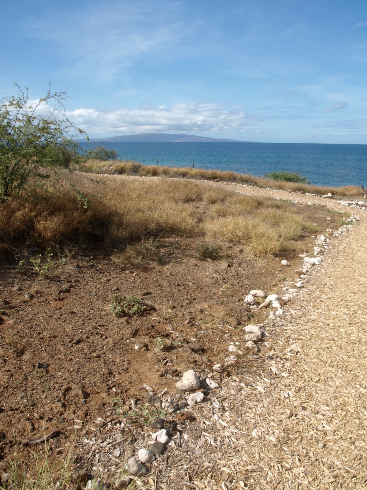
On Maui, Haleakala National Park is has many of the island's top trails for wildlife watching. To spot a rainbow variety of bird life, start with the short loop around Hosmer Grove or sign up for a longer guided hike into Haleakala's wet, wild Waikamoi Cloud Forest, managed by the Nature Conservancy. Day hikes and overnight treks around the park's volcanic summit will bring you almost nose-to-beak with nēnē, the endangered Hawaiian goose.
Back along the central Maui coast, Kealia Pond National Wildlife Refuge has built a boardwalk that lets you spy on not just rare native and migratory Pacific birds, but also sea turtles basking down below on golden sands. In West Maui, the Kapalua Resort's hiking trails are open to the public. Explore the shady Maunalei Arboretum of native and exotic trees, then trace the windblown, rocky coastline of Kapalua Bay, where humpback whales swim and give birth in the warm offshore waters in winter.
You can find out more about all of these hikes in my book Top Trails Maui: Must-Do Hikes for Everyone, available in paperback from Wilderness Press and also as an Amazon Kindle ebook.
Related links:
Slow Down, Save an Endangered Nene on Maui
Hidden Hiking Trails in West Maui
Risks and Rewards in the Big Island's Volcanoes and Valleys
Photo credits: Kihei & West Maui Mountains (Sara J. Benson & Michael Connolly Jr.)
February 21, 2013
Leave Your Car in LA - Take Amtrak Instead
.JPG) It was more than 10 years ago that I first hopped an Amtrak train from San Francisco to Los Angeles. When we rolled into LA's Union Station over four hours late in a rainstorm, it made me think twice about taking the train again. Since then, I've driven the SF-LA route dozens of times, often swearing in frustration at big traffic jams on the I-5 Fwy.
It was more than 10 years ago that I first hopped an Amtrak train from San Francisco to Los Angeles. When we rolled into LA's Union Station over four hours late in a rainstorm, it made me think twice about taking the train again. Since then, I've driven the SF-LA route dozens of times, often swearing in frustration at big traffic jams on the I-5 Fwy. This week I boarded the Coast Starlight train again and gave Amtrak another shot. Not only was the train impeccably on time, it was even more comfortable than driving my own Subaru. My upper-deck train seat was at least twice as wide as on a plane, and when the coach car attendant walked around handing out free sleeping pillows, I was gobsmacked.
During lunch in the dining car, as I was looking out panoramic observation windows onto the Pacific coast, I whiled away a relaxing hour chatting with other travelers. Mostly we talked about why we chose to take the train instead of driving or flying: the slower pace of rail travel, the unbeatable views, and bonding with family and friends en route, not to mention shrinking our carbon footprints.
When the Coast Starlight chugged into the tiny train station that was my final destination, I was reluctant to step off onto the platform. When was the last time I felt that way about an airplane ride? Never.
Come over and join me on Instagram to see more pictures of this week's California trip by train!
Related links:
Coastal California: The Anti-Hotel Top 10 List
All Aboard Amtrak's National Train Day
Fall Travel: Sunshine on California's Coast
Photo credit: Sara J. Benson (postcard via Gogobot)