
Daniel M. Russell's Blog, page 30
November 11, 2020
SearchResearch Challenge (11/11/20): What happened here over the past 40 years?
When I was young my family would go on long car trips...
 Shields Date Farm--with excellent date milkshakes.
I know, it's a quintessentially American thing to do, but that's what we did in the summers of my youth--travel from Los Angeles to my grandparents places in either Wisconsin or Oklahoma, visiting various and sundry aunts, uncles, and cousins along the way.
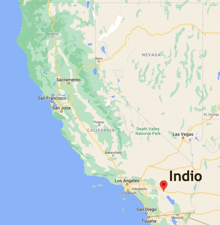
One of the most exotic and fun parts of the trip was driving through the area near Indio, CA. It's about 100 miles due east of LA, smack in the middle of the desert, famous as a place that's between the Salton Sea and Palm Springs, pretty close to the city of Coachella. It's flat, very warm and reminiscent of the deserts of the Middle East.
No surprise, then, that the area around Indio became famous for their groves of date palms in the Coachella Valley.
But for a young kid driving across California in those pre-Coachella Festival days, the big appeal of Indio was the date shakes. They seemed SO exotic and tasted SO wonderful that it was a great attractor. The kids would lobby hard to make sure we drove through Indio during business hours, even though it would probably be pretty hot. That only made the date shakes even better. Shields Date Gardens has great shakes, but also a documentary about the "romance and sex life of the date." How could Mom & Dad NOT stop there? It's educational! (Here's the YouTube version of that film, should you want to see it.)
I haven't been there in probably 20 years (I found a closer source of date shakes), so I was fairly surprised when I happened to look at the Coachella Valley on Google Maps. It's a MUCH different place than I remember from the days when we drove through in search of date-based frozen confections.
That leads us to this week's Challenge:
What are the largest changes to landuse in the Coachella Valley over the past 40 years? (That is, the valley centered around: 33.711896, -116.210818) What kinds of changes can you spot?
For this Challenge, we don't need a complex dataset search, but something more direct. That is, how would you look at the landuses of the acreage in the valley? What's a good tool to get that kind of information--and then how can you start to look at it and understand what's happened?
Once you figure this out, let us all know what you did to understand the changes. What sources do you go to?
Search on!
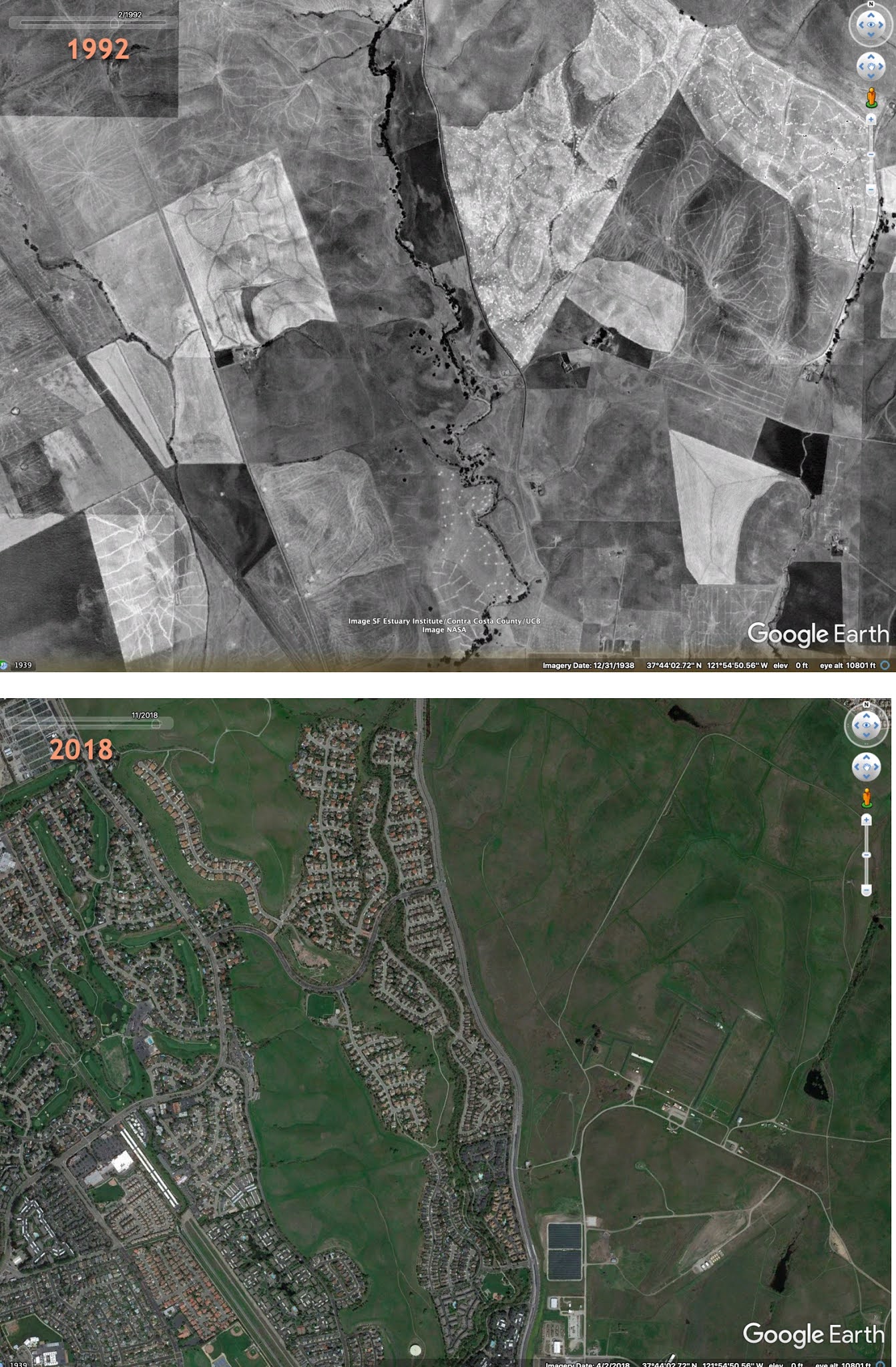
(Inspirational image below... 26 years of change near Dublin, CA.)


November 4, 2020
SearchResearch (11/4/20): Looking for data? Here are 3 Google data set sources
These days I find myself searching for data more often...

... if only to reassure myself that there really is a quantifiable perspective on the world. Data isn't objective, but it's harder to fake your argument if there's data to look at and test. Having data gives your argument/discussion a clearer path to clarity.
As you know, Google enjoys data. It enjoys it so much that we've made three different ways to find data sets that might be interesting to you. Here they are...
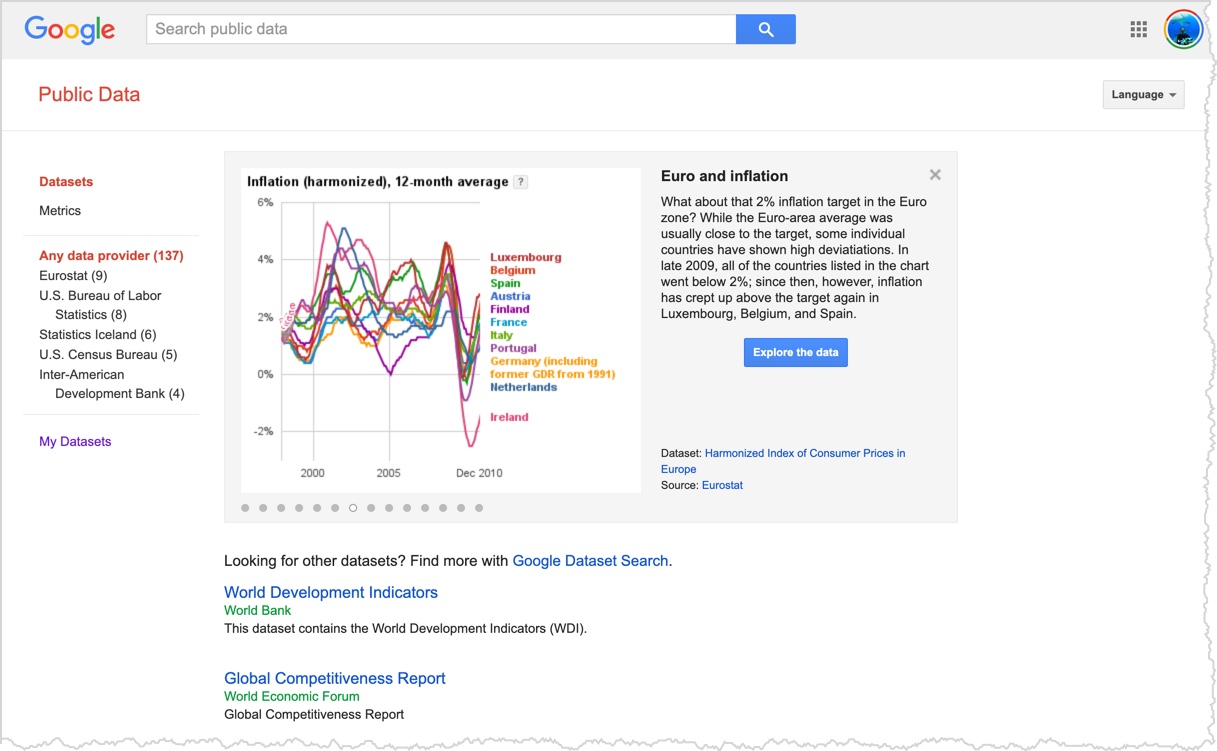
1. Dataset Search. We've talked about this new search product before (SRS Jan 24, 2020). It's a search tool that lets you search for different kinds of data sets. As you can see, a simple search gives pointers to many different datasets, each of which is hosted on the dataset provider's site.

This is a great way to get the data directly from the source. You can read the original source metadata, release notes, etc.
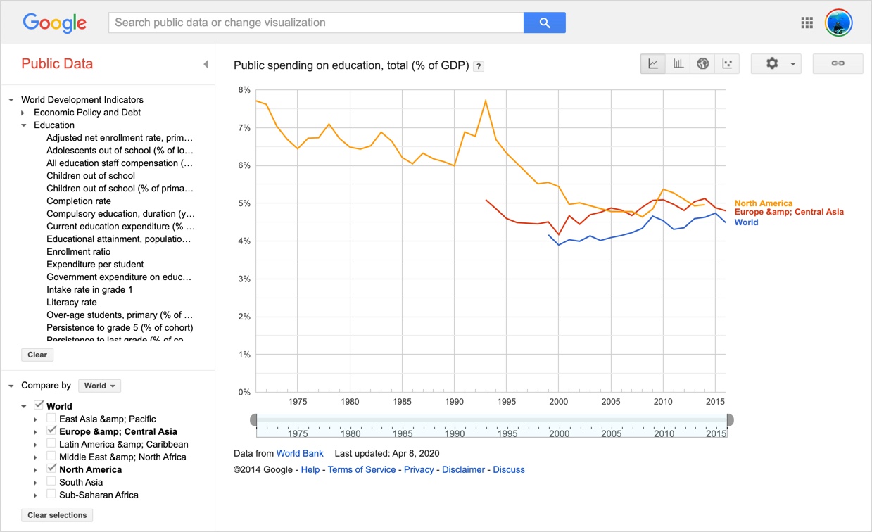
2. Public Data Explorer. We've talked about this before as well. (SRS July 3, 2010). It's a curated collection of data sets from a host of high quality sources. In this case, the data is hosted on Google servers, so even when the host is down (or updated), you can still get to the data.
PDE has a number of data sources you can explore with visualizations, etc. Such as this fairly sobering chart of spending on education over time.
3. Data Commons. The newest data source is the Data Commons project which aggregates a lot of different kind of data sets and provides access to them via APIs and Google Sheets. That is, not only can you look up data, but you can write code that accesses it directly! That is, the Data Commons is an aggregated dataset structured around different kinds of entities: places, people, organizations, etc. All that data is organized into a graph that lets you write fairly straightforward pieces of code (or do specialty searches) to do different kinds of work.
All data is scanned (with permission!) from databases and pulled into the Data Commons graph. You can think of it as facts about those entities, making the resulting dataset a valuable source of combined entity-oriented data.
The data vocabulary used to structure the Data Commons graph builds upon Schema.org, the most widely used vocabulary for structured data on the web, and is documented at schema.datacommons.org.
Here's a quick example.
Using Google Sheets, I created a sheet and enabled the DataCommons Add-on. Once you do that, you can make a list of different geographical entities. Then you can write a simple Spreadsheet function that pulls data from the DataCommons directly. An example:
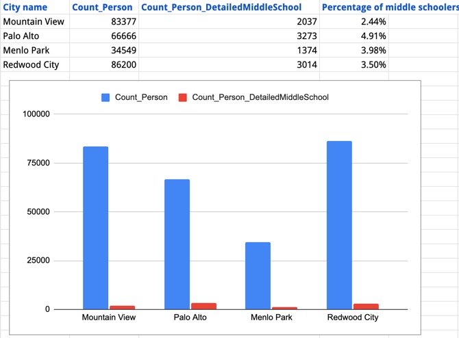
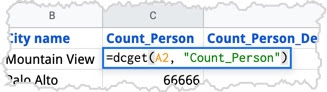
In this spreadsheet, I put the city names in the far left column, then wrote a couple short retrieval expressions and got the population of each city, the number of middle-schoolers in that city, and then computed the percentage of the city's population that's in middle-school. This is what those cell expressions look like:
Finally, I made a quick bar chart to show the size of each city's population and the size of each city's middle-schoolers. Sweet. (Total time: around 2 minutes.)
So, what's the difference between these dataset tools? DataCommons is very selective about its sources and about integrating them into the master graph. It goes deep into the data, aggregating many sources and reconciling the different data types (e.g., it integrates BLS data + Census + a few others). By contrast, Dataset Search goes wide, finding datasets about anything anywhere. For breadth, use Dataset Search; for details and single-point-of-access, you want DataCommons.
As you might imagine, this would be really handy for some of our SRS Challenges.
If you're curious, you can go do this same example by looking at the DataCommons documentation, or you can wait a week (or so) until I get around to posting a Challenge that will need this skillset.
Search on!
October 28, 2020
SearchResearch: Two weeks off.... but not really...
These are complicated days, and it's unclear what or who's in control...

From the Apollo Operations Handbook Block II Spacecraft (October 15, 1969).
This is a truly complicated user interface. P/C NASA
Between the drama of the US election, the issues with COVID-19, various economic issues, wildfires in California, and yet-another hurricane about to land in Louisiana, the next couple of weeks are going to be busy.
So I'm declaring a two-week mini-holiday from SRS Challenges.
But don't look away.
Over the next two weeks we won't have our usual Challenge + Answer, but I'll be writing up a couple of posts and making a couple of videos that don't quite fit into the normal SRS narrative. In most cases, these are things I've wanted to write about, but didn't quite have the time. I think you'll enjoy these posts--I hope they appeal to your SRS curiosity.
And, of course, if you have something that you'd like me to write about, please leave me a note in the blog comments below or email me directly.
See you online in some new posts!
Search on.
October 21, 2020
Answer: How are the kelp forests doing?
The kelp forests are magnificent.
But how are they faring in the face of climate change?
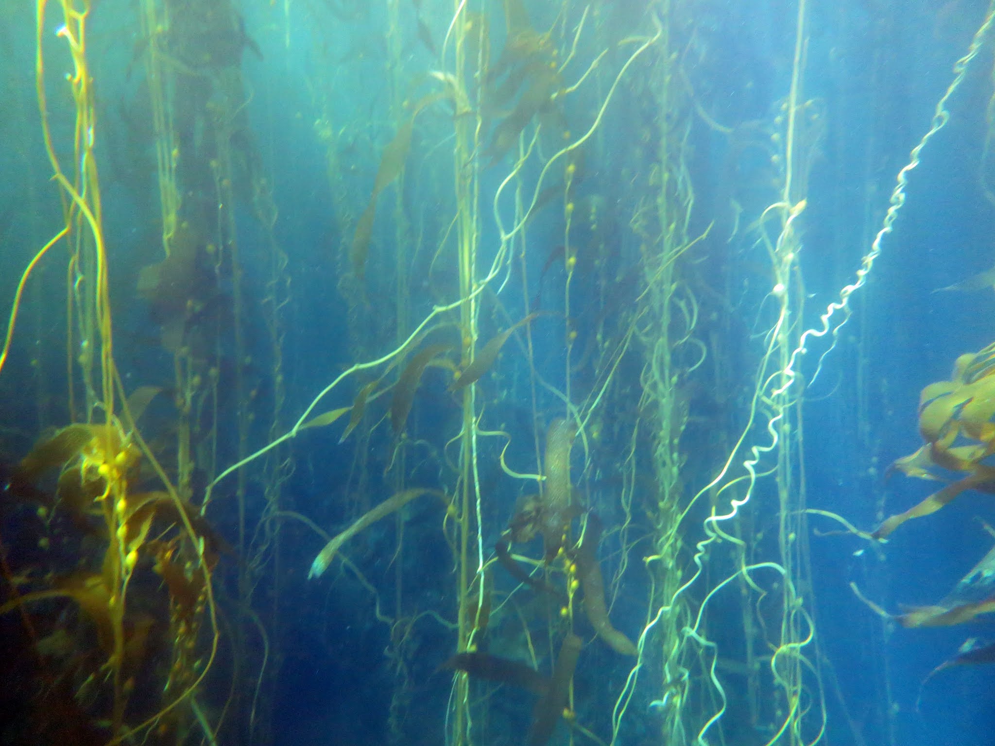 Photo by Dan, taken in a kelp forest near Santa Rosa island.
As I mentioned in the Challenge, I mean JUST kelp--that is, members of the Laminariales family, and specifically, the kelp that grows along the California coast.
Sidebar mini-lesson: Across the family of kelps there is huge variation in size, morphology, life span, and habitat. Some are annuals while others are long-lived perennials. They inhabit areas ranging from the tropics to the High Arctic, and from the intertidal down to depths of 70 m. Kelp commonly grows in aggregations called beds or forests, which usually forms a dense subsurface canopy. Some kelps have gas-filled structures that allow them to produce a floating canopy that extends to the surface in water depths as great as 30 m.
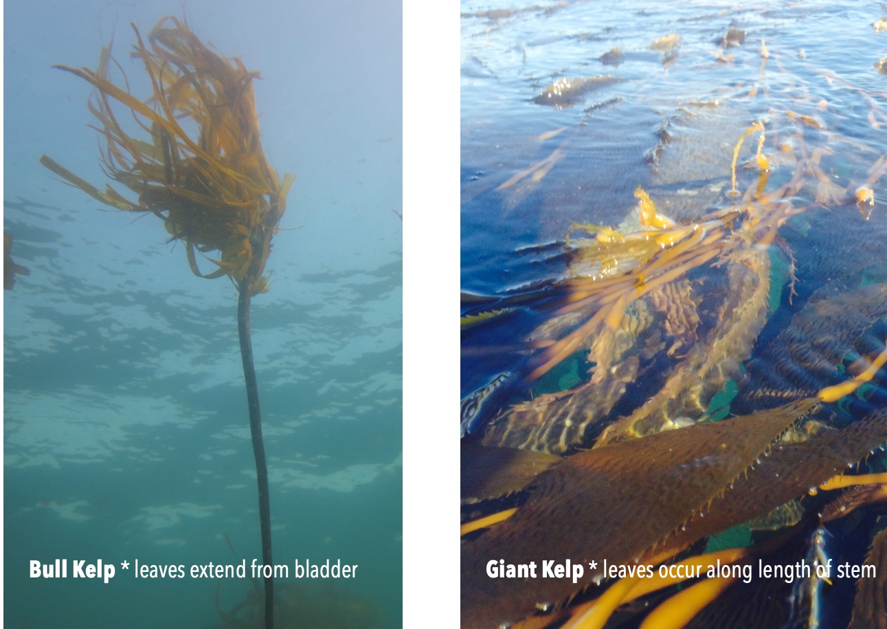
For this Challenge we're interested only in kelp that grows along the California coast. And there are really two dominant kinds: bull kelp (Nereocystis luetkeana) and giant kelp (Macrocystis pyrifera). Here they are side-by-side for comparison. They look very different, but both colonize Californian waters.
I've noticed over the years that kelp forests seem to come and go. There certainly have been changes, sometimes dramatic, sometimes minimal. But is this fluctuation normal? How much of those changes would be considered "normal"?
That curious question leads to last week's Challenges:
1. How are the California kelp forests going these days? Are they healthy?
Let's begin with the simplest possible query:
[ kelp health California ]
Since I'm not sure what I'm going to find, I'll open the first 5 results (which all look to be from good sources) in parallel--that is, in different tabs. Here's what that looks like (click to see it full-size):
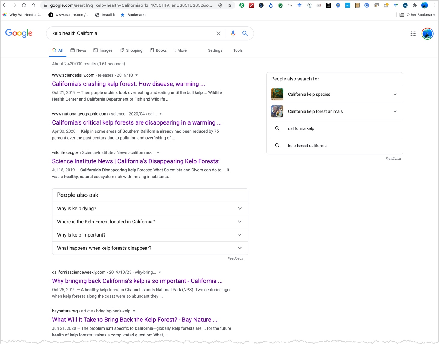
Just scanning the snippets makes me think that the kelp is in a pretty dire state.
I then opened and read each of the top 5 tabs, opening only the results that I thought were pretty high quality links. (This is lateral browsing--a great technique for doing a quick broad search.)
Here's what I found:
1. Science Daily (Oct, 2019) Kelp forest are crashing due to purple sea urchins, which grew wildly in number after a disease devastated the sea stars (which control urchin numbers).
2. National Geographic (April, 2020) This is behind a paywall, but I happen to have a NatGeo account, so I just logged in and read it. Same story: Purple urchins wiping out the forests. Interesting note embedded in this article--the historic max acreage of kelp in California was around 2500 acres. Also, a small section of kelp is being restored to health by sending out divers with hammers to kill off the purple urchins. (Great idea, but labor intensive.) { side comment: That 2500 acres number seems small to me. See the map at the bottom of this post.}
3. California Dept. of Fish and Wildlife (July, 2019) Another confirmation of kelp forests being destroyed by purple urchins. In the past 5 years, California's kelp forests have declined by 95%. Repeat of the death of the sea stars (beginning in 2013) leading to urchin explosion, leading to kelp devastation. Plus, a patch of warm water formed on the coast (2014) which stresses the kelp, slowing growth and reproduction.
4. California Science Weekly (Oct, 2019) Repeat of the story, with the additional twist that the warming trend is what led to the loss of sea stars. This article also pointed to a fascinating article with long-term data about California kelp in the esteemed science journal Nature. (When I read this, I thought "Aha! This will be useful for Challenge #2!" It was. See part 2, below.)
5. Bay Nature (June, 2020) Repeat the same story as before, but with extra data--they claim that 90% of the kelp along a 200 mile stretch of Northern California has disappeared. (The story centers on Fort Bragg, in the top quarter of the state.)
That's five different sources (and they don't draw on the same studies, so far as I can tell), all recent, all respected, all telling the same sad story. The kelp forest is fairly down from historic levels.
Just to be sure, I went down another 10 results.. but it was all the same news.
2. Can you find some data about the state of the kelp forests? How can one measure the forest and create a data set to analyze kelp forest health over a span of decades? Can you find such a multiyear data set?
So... What I'd like to see is data about kelp over the long term. This is called a longitudinal data set. My strategy is to start with a query asking about this topic broadly, then search for a specific longitudinal data. That is, we started with:
[ kelp health California ]
This search led incidentally to an article in Nature by the folks at the Coastal Marine Science Institute (UC Davis, in Bodega Bay, CA) about the health of kelp. (As you know, Nature, the science magazine, is a very reputable resource, so this is a pretty good citation. Rogers-Bennett, L., and C. A. Catton. "Marine heat wave and multiple stressors tip bull kelp forest to sea urchin barrens." Nature Scientific Reports, 9.1 (2019): 1-9.
That article, pretty much sums up the state of affairs over a twenty-year period:
"Twenty years of kelp ecosystem surveys reveal the timing and magnitude of events, including mass mortalities of sea stars (2013-), intense ocean warming (2014–2017), and sea urchin barrens (2015-). Multiple stressors led to the unprecedented and long-lasting decline of the kelp forest. Kelp deforestation triggered mass (80%) abalone mortality (2017) resulting in the closure in 2018 of the recreational abalone fishery worth an estimated $44 M and the collapse of the north coast commercial red sea urchin fishery (2015-) worth $3 M...."
The outlook is pretty grim. Figure 3 in the paper sums it up in a single sad chart:
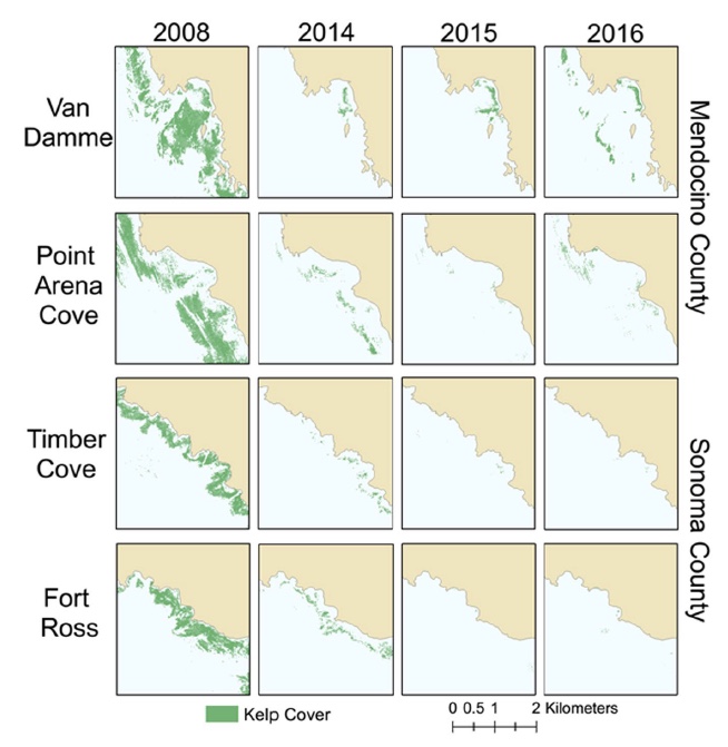 Surface kelp canopy area pre- and post-impact from sites in Sonoma and Mendocino counties. From: Marine Heat Wave....
In reading through this paper, I notice that it's only for Northern California. So I repeat the query, but adding in "southern" like this:
[ kelp health southern California ]
which eventually led me (after skimming through about 10 papers that looked good, but didn't have the data) to the California Department of Fish and Wildlife's article on "Aerial Kelp Surveys" which includes another long-term chart showing areas of kelp coverage over the past 27 years:
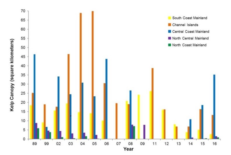 Aerial kelp survey results, 1989-2016 (surveys were not conducted in all regions and years). Regions: South Coast – Point Conception to the California/Mexico border; Channel Islands – the eight Channel Islands offshore of southern California; Central Coast – Pigeon Point to Point Conception; North Central Coast – Alder Creek near Point Arena to Pigeon Point; and North Coast – California/Oregon border to Alder Creek near Point Arena. Figure from Aerial Kelp Surveys by Ca. Dept. Fish and Wildlife.
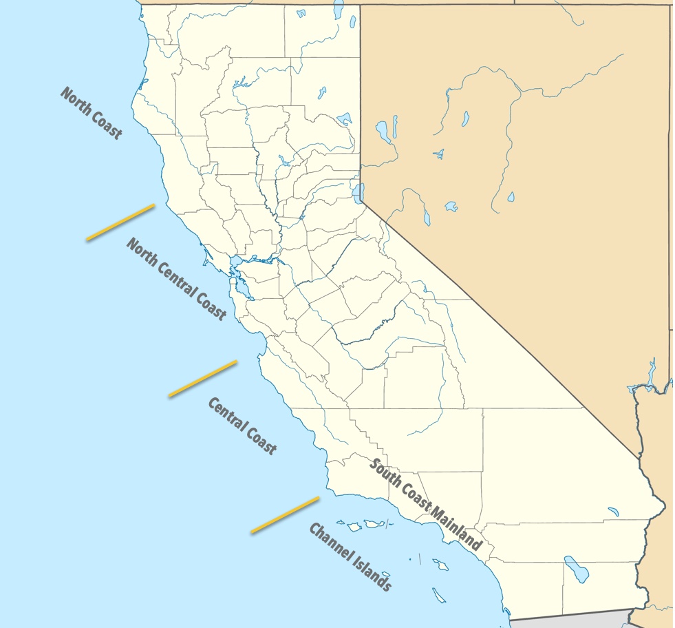
And a map to orient you so you'll know where those regions are:
This chart shows a worrying trend. If 1989 / 1999 are the baseline definition of "normal" kelp cover, then the Channel Islands (in Southern California) and the Central Coast have been doing relatively well, while the North Coast and North Central areas are suffering badly, especially since 2009.
This is all consistent with the other articles I read along the way. A combination of relatively warm sea water, the loss of sea stars, and the growth in numbers of sea urchins have led to a loss of kelp throughout the state.
But perhaps there's a glimmer of hope; if whatever is happening in the Central Coast and Channel islands can be replicated elsewhere...
Interestingly, this paper ("Aerial Surveys..") also had a link to California state's kelp survey data! (All papers should have dataset access like this!) If you have the time and interest, it's all there.
Even better, that data comes with a viewer that lets you load in the data of a given year and visualize it on the map of California coastal waters. Here's what that looks like for the kelp survey data from 2002, a fairly "normal" year (check out 2002 in the above chart).
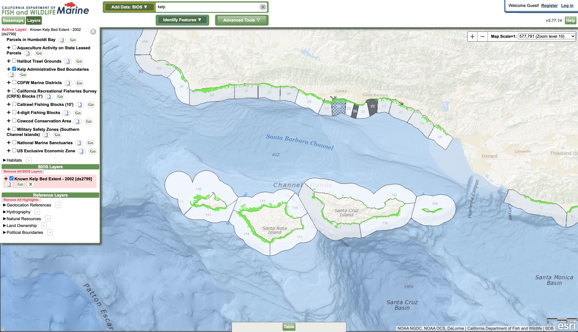
As you can see, the kelp forests are fairly extensive, surrounding almost all of the Channel islands. If you did a cursory measurement, you'd realize that the kelp forest occupies much more than 2500 acres!
In any case, there's the data for the past 27 years, with detail data for 20 years of the north coast, all of which points to a disaster all along the coast, but with a small point of hope. I'll leave it to you to do the research to see how/why this hope might arrive. It's still a slim chance, but it's not utterly lost.
1. Define your terms. In this case, kelp seems pretty straightforward, but it's good to be precise (it makes comparisons SO much easier).
2. Lateral browsing lets you see many sources side-by-side, making comparison much simpler. My first query worked pretty well--so well that I was able to open 5 tabs side-by-side and see what source had the information I wanted. This also lets me look for multiply-sourced information.
3. Pay attention as you scan the articles. As I was reading the articles looking for the overall health of the kelp, I just-happened to notice articles with longitudinal data. Of course it helped that I was primed for it--I knew that was the next Challenge. Deep point: Think at least one move ahead as you do your research--what kind of data will you need to answer your next question? Then, as you do your SearchResearch, take notes... you never know which of those results (like the "Marine Heat.." article) will lead you to the data you really need.
4. Pay attention to what's missing. To tell the truth, I didn't notice that the data for Southern California was missing in the first article. I was so excited about finding 20 years of data that I kind of overlooked the gap. It was only when I thought to check the kelp coverage in the Channel Islands (way down south) that I noticed the missing data. It wasn't hard to modify the query to find the [kelp health Southern California], but it would have been embarrassing to have missed half of the state!
There's so much more we could do with this Challenge. I had initially done a search using the Dataset Search tool, but that led to a whole other investigation! If I have time this week, I'll write to you about that.
In the mean time, take care of your queries, and...
Search on!
October 7, 2020
SearchResearch Challenge (10/7/20): How are the kelp forests doing?
One of the glories of plant life on planet Earth are the great kelp forests along the coasts...
Photo by Dan, taken in a kelp forest near Santa Rosa island.Near me, along the coast of California, is an 800 mile long coast that has historically been an almost continuous kelp forest. Kelp has historically run from Baja Mexico up to Alaska. (This kelp is all members of the Laminariales family; I don't mean "seaweed" in general, as the term kelp is sometimes used.)
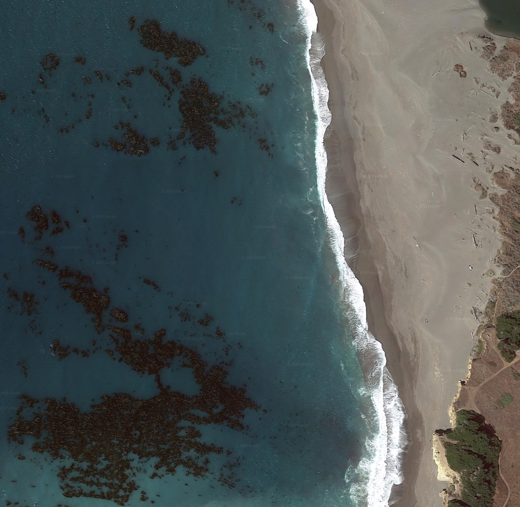 The coast of California used to look much like this. The dark areas in the water are stands of kelp.
 Was this forest near Gualala, CA larger in the past? How would you know?
I grew up snorkeling and diving the Los Angeles area coastline, and as I recall, the kelp forest was luxurious, dense, and grew fairly close to shore.
It can be intimidating to swim through, but if you've been in heavy kelp enough, you quickly learn to control your panic when it seems to wrap tightly around your ankles. It's pretty slippery stuff, so as long as you don't make any quick movements, but if you slowly and carefully untangle yourself, it's not bad.
Well, there was that one dive off Santa Rosa island where my feet got pretty tangled up with only 500 psi left in my tank... at 45 feet deep. That's a moment that'll decalcify your spinal column. But a bit of slow breathing and carefully reaching down and unwrapping my ankles got me free. Move slowly and carefully, don't panic. It was maybe only twenty seconds, but felt like twenty minutes.
As I travel up and down California these days, I can't help but notice the kelp beds that line the coast. I've read a few articles about the changes in kelp that have been happening over the past 30 years, but I wonder--what's really going on? Is it truly getting better? Or are things getting worse?
That curious question leads to today's Challenge:
1. How are the California kelp forests going these days? Are they healthy?
2. Can you find some data about the state of the kelp forests? How can one measure the forest and create a data set to analyze kelp forest health over a span of decades? Can you find such a multiyear data set?
What say you? Can you find this information?
As always, be sure to let us know HOW you found it. Did you use a special resource? Did you use a particular set of search terms? Enquiring minds want to know!
Search on!
October 5, 2020
PowerSearching course now on edX platform!
Exclusive SearchResearch news flash!
 PowerSearching Logo
The PowerSearchingWithGoogle online class is moving to the edX platform!
If you're a Regular Reader of SearchResearch, this is a course you might have already taken. But for teachers and people who want a recommendation about where can I learn all this stuff, here's an opportunity to get a quick dose of what it means to be a skilled online researcher.
I've wanted to make this shift for a while--the old platform was growing increasingly difficult to maintain. So when the edX folks offered to host PowerSearchingWithGoogle, I was extraordinarily pleased. They'll keep the boilers fired up and at the correct pressure, fixing little things as they go haywire from time to time.
The course is an updated version of the old course (hurrah!), and comes in two flavors.
(A) FREE: You can audit the course for free and get all of the experiences and lessons that I've created.
(B) Certificate: You can pay some amount of money and take the course for a certificate. Bear in mind that it's a certificate from edX saying that you've passed all of the tests given in the course. It doesn't have any additional credential than that--but if that's what you want, it's an option for you.
There will be an official announcement from edX and Google coming later this week--but I wanted you to have the insider knowledge that comes with being a SearchResearch reader.
To get to the new edX course:
PowerSearchingWithGoogle.com (on edX)
Note that you need to create a (free!) edX account beforehand. Then you just register for the course and start enjoying.
Of course, if you find any bugs, let me know and I'll fix them!
Search on!
October 2, 2020
Answer: Digging deeper into the story behind a photo?
Curiosity...
... is one of those personality traits that some people find endearing while annoying others. Personally, I'm a curious person, so I find a curious person to be engaging and fun.
This week's Challenges are drawn from things I saw that made me say why is THAT the way it is?
Let's unpack these Challenges and see how curiosity helps us find some understanding:
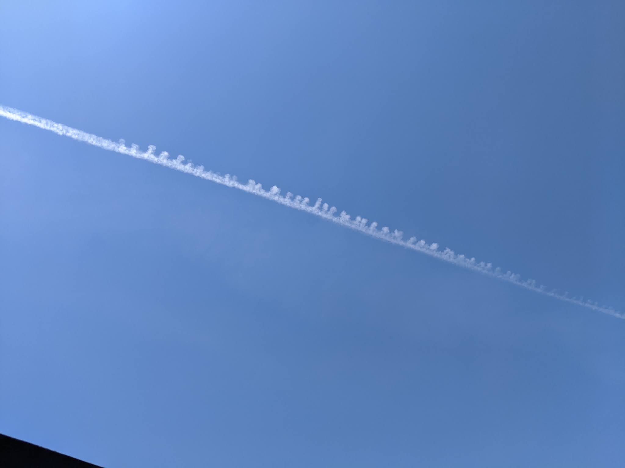
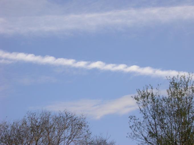
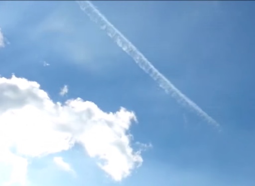
1. Here's a pic I took the other day in my back yard. I live not too far from San Francisco International airport, so it's common to see contrails in the sky. But this one seems unusual to me. For lack of a better term, it's unusually poofy with lots of blobs along its length. What's going on with these poofs on the contrail? Does this happen often? Is there a name for this phenomenon?
This one of those fairly common moments in SearchResearch: what do you search for here? That is, what search terms are most likely to tell you what you need to know?
In cases like this, you have to count on learning as you search--picking up terminology that you can then use for your actual search.
I started with:
[ contrail puffy ]
led me to an article by the Royal Meterological Society (UK) called Contrail lobes or mamma? The importance of correct terminology, which seems singularly appropriate as I'm casting about for better search terms. This article talks specifically about the lobes that sometimes form on contrails.
As this article points out, the terminology is varied:
The lobular cloud regions in contrails have been variously called ‘drop‐like formations’ and ‘pendulous lumps’ (Ludlam and Scorer, 1953), ‘blobs’ (Scorer and Davenport, 1970), ‘pendant swellings like inverted mushrooms’ (World Meteorological Organization, 1975, p. 66), ‘pendules or fingers’ (Schaefer and Day, 1981, p. 138), ‘puffs’ (Lewellen and Lewellen, 2001), ‘clumps of condensate’ (Rossow and Brown, 2010), ‘smoke rings’ (Unterstrasser et al., 2014), and ‘tear‐drop structures’ (Paoli and Shariff, 2016). They have also been called ‘mammatus’ (Ludlam and Scorer, 1953; Schultz et al., 2006; Unterstrasser et al., 2014), ‘akin to mammato‐cumulus’ (Day and Schaefer, 1998), and ‘mamma structures’ (Paoli and Shariff, 2016).
This discrepancy in terminology in the literature (as well as public‐facing websites discussing contrails and meteorology) raises an important question as to what should be the appropriate scientific name for these features...
What should I use for my next search? Well, many of these terms are fairly common ("drop-like formations" can describe icicles as well as clouds). The big question for meteorologists is Why does a smooth cloud develop these lobes? In meterologist terms, What causes a mammatus formation in a contrail?
But since the term mammatus is fairly rare I tried:
[ mammatus contrail cause ]
And that led to a bunch of articles, all of which are fairly technical. Seeing so many tech-focused articles makes me think that we should look in Google Scholar (which gives us 52 hits for this query). But they're pretty good hits.
One paper in particular seems right up our alley: The Mysteries of Mammatus Clouds: Observations and Formation Mechanisms, by Schultz, D. M., Kanak, K. M., Straka, J. M., Trapp, R. J., Gordon, B. A., Zrnić, D. S., ... & Lilly, D. K. Journal of the Atmospheric Sciences, 63(10), 2409-2435. (2006).
Fortunately, this is an open access paper, so we can read it carefully.
As the authors write, sadly for us:
Because they are not directly related to significant weather events on the ground and they do not apparently hold insights into forecasting severe convective storms, mammatus generally have been viewed as no more than a curiosity in the atmosphere. Consequently, published research on mammatus is rather limited, and what literature exists is either highly speculative or severely constrained by the limited nature of the observations.
Well... rats! But I'm curious enough to read through the rest of the paper.
Pressing on, though, we read that in the "Mechanisms" section of the paper there are several different thoughts about why a cloud (such as a contrail) might form mammatus shapes. If we ignore the proposals for mammatus formation in anvil-shaped clouds (thunderheads and the like that don't apply to long, linear contrails), we see there are 3 different suggestions:
1. local inhomogenities: that is, slight differences in the way the air is moving, causing a linear cloud (contrail) to be pushed into lobes. There's some evidence from Doppler radar studies for this, showing that the air really is moving at different speeds in the lobe vs. outside the lobe. This could be just due to local differences in winds from the sides, spreading out the contrail a bit.
2. "gravity waves" in the atmosphere: This sounds more sophisticated than the reality--"gravity waves" are really just pressure waves. The idea is that as the plane moves through the air, it generates a series of waves (think of little shock waves) that persist for some time after it passes. As the homogeneous contrail cloud is formed, it encounters pressure waves of air left in the wake of the plane, forming regular pulses in the contrail.
3. Kelvin–Helmholtz instability: This happens when a stratified fluid (the air) has strong vertical wind shear (air currents at an angle to the direction of the contrail formation). In at least one case, wave-induced vertical motions inside clouds seem to be associated with mammatus clouds at the cloud base, perhaps the most convincing evidence published to date that K-H instability causes mammatus clouds. Would this work on contrails? A quick search for
[ Kelvin-Helmholtz contrail ]
leads us to the Earth Science Picture of the Day and this image:
 A Kelvin-Helmholtz contrail. P/C John Adams. From Earth-Science Picture of the Day.
Overall, there are several different mechanisms that could create the pulses (or lobes) that we see on contrails. They're all somehow related to local "inhomogeneous" conditions in the contrail, each causing a volume of air to disperse differently than the one next to it... and that leads to a regular pattern of lobes along the old contrail. I'm willing to bet that the pressure waves are caused by the plane itself. (But I admit that this is a guess based on the papers I read.)
Note that older planes can also create contrails, although they're usually at lower altitudes and are mostly vapor, rather than ice crystals as we see in jet contrails. Vapor droplets happen when the air is humid and there's a sudden pressure drop, as sometimes happens over winds and at the tips of propellor blades.
 Contrails created by the propellors of B17 bombers during World War 2. Note the mammatus structure of the earlier contrails in the image. It's not just a jet-age phenomenon.
As you might expect, there are many different kinds of contrails, different conditions and probably different explanations for the lobes in the contrails. As I was reading the above papers, in the reference list I noticed a reference to time-lapse study of contrails... so I naturally look for videos:
[ time lapse contrail ]
and find all kinds of videos, including this one from Encyclopedia Britannica:
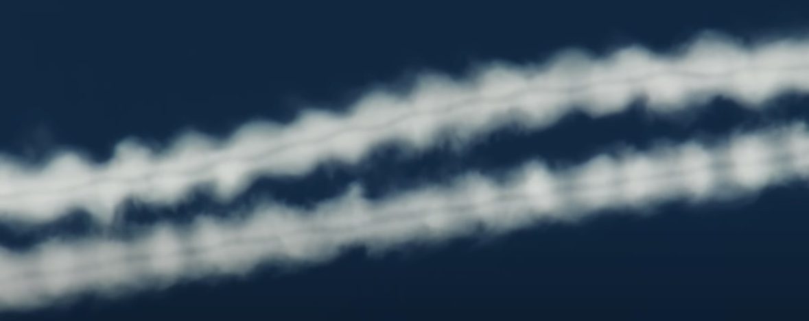
which has this image at 0:15:
It's just at this point you can see the puffy / blobby / mammatus structure starting to form. What clearly starts as a fairly smooth and undifferentiated cloud fairly quickly organizes itself into lobes.
Regular Reader Jon (the Unknown) points us to Crow Vortex instability (or the Wikipedia article) as another mechanism for making pulses in contrails. It happens when the wingtip vortices interact with the engine contrails, producing visible distortions in the shape of the engine contrails.
As an example, check out this compelling YouTube video:
At 2:26 in this video you can see a striking image of two helically rotating vortices:
While Crow vortex effects are beautiful, they probably didn't cause my original picture, which seems very one-sided.
I'm not sure I was able to quite answer the Challenge question ("what causes.."), but I think we got to the limit of scientific knowledge.
2. Here's another photo I took while hiking on a trail next to a channel in the greater Los Angeles area. I'll spare you from having to extract the lat/long from the photo (it's 34.1628333,-117.9922528). It's not the most exciting trail in the world--it follows along a fairly barren path next to this concrete channel for quite a ways before getting to Monrovia Canyon Park (which is quite nice).
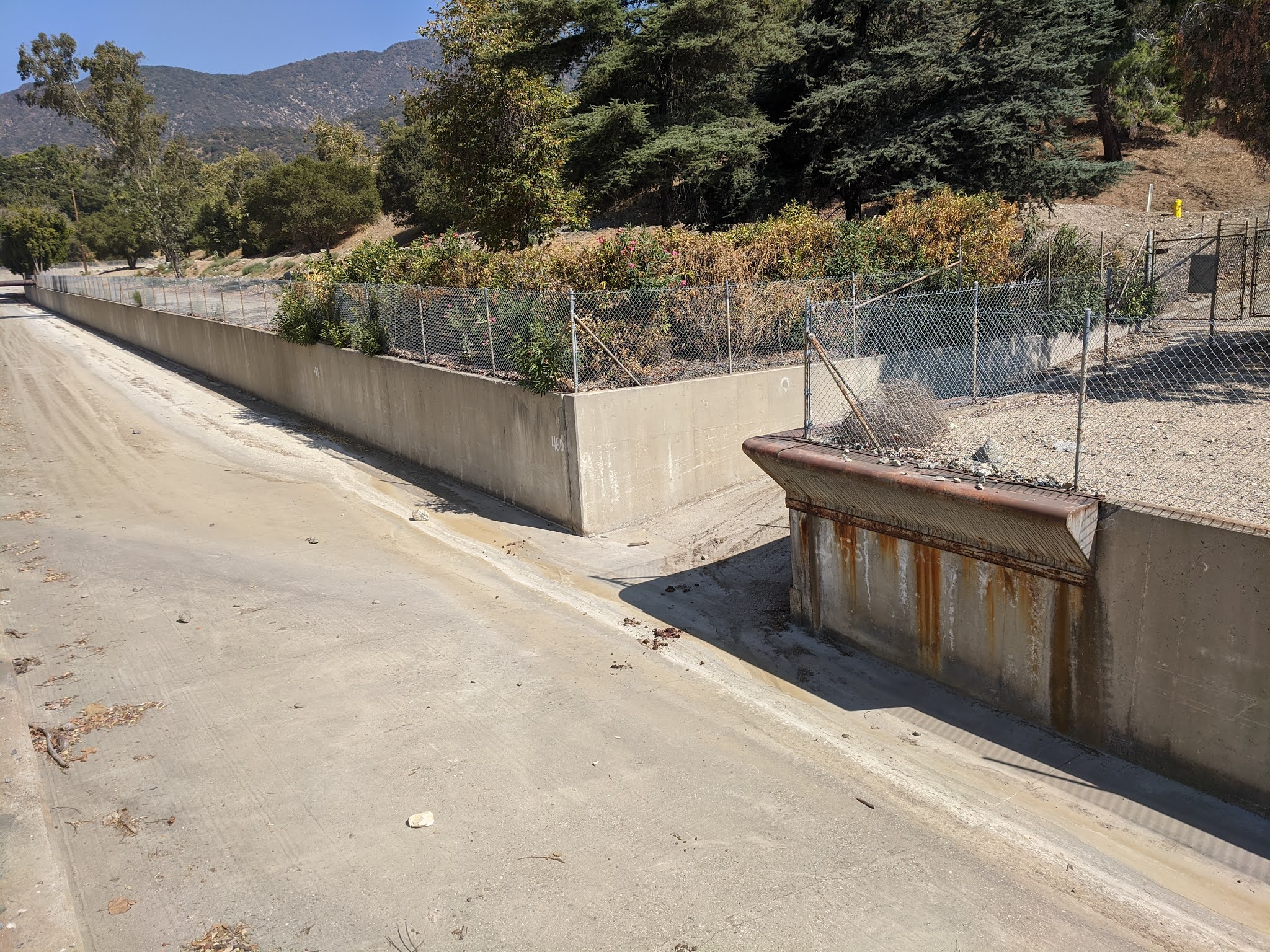
As you can see, for most of its length, the concrete channel has plain square walls. Here, though, there's a kind of angled buttress on one side of one corner of the place where the ramp enters the channel. Why is it there? Why would someone feel the need to build this special buttress?
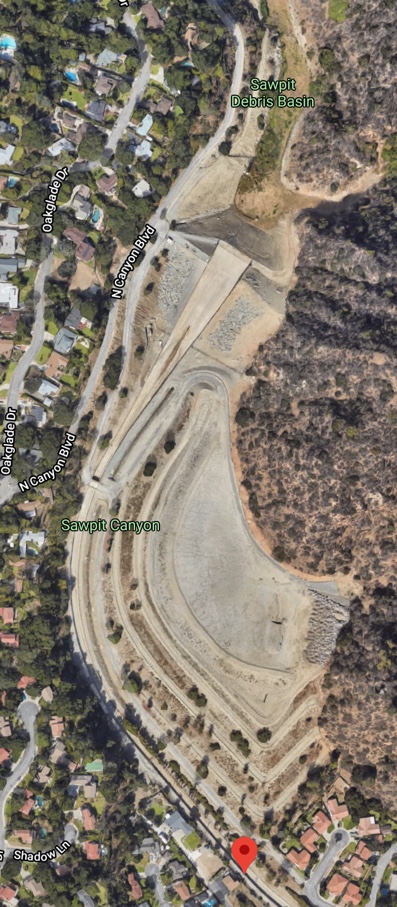
To get an idea of what I was looking at here, I first checked Google Maps. There, I saw that this channel was connected to the "Sawpit debris basin" via a concrete channel in "Sawpit Canyon."
 Click on image to see at full size.
This is taken from Google Maps at 34.1628333,-117.9922528
First question that occurs to me: What's a debris basin? If you do that as a query, you'll quickly find LA Public Works answer to that query:
Debris basins are facilities designed to capture sediment, gravel, boulders, and vegetative debris that are washed out of the canyons during storms but allow water to flow into the downstream storm drain system, thereby reducing flood risk for communities downstream of the facility. They are typically located at the mouths of canyons and are key components of the Los Angeles County Flood Control District's flood risk management system.
In unburned watersheds, debris basins are cleaned out once they are 25 percent full. The number of years it takes to reach that level varies. In burned watersheds, where the potential for mudflows is higher, debris basins are cleaned out once they are 5 percent full. A watershed that has had more than 20 percent of its area burned within the previous 5 years is considered a burned watershed. For some debris basins in burned watersheds, this may lead to multiple cleanouts within a year.
If you look just a bit upstream from our spot on the channel, you'll see Sawpit debris basin, behind what looks like a dam. But if you look for:
[ list of dams in Los Angeles county ]
you'll find the official LA county list of dams and reserviors, and Sawpit isn't listed there. Hmm.
When I see something like this, I get curious--so I will try different kinds of maps. If you check out Open Street Maps, you'll see this:
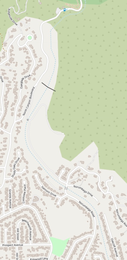
You can see what looks a LOT like a dam right where the Google Map shows "Sawpit debris basin." Compare this to the Bing map of the same area:
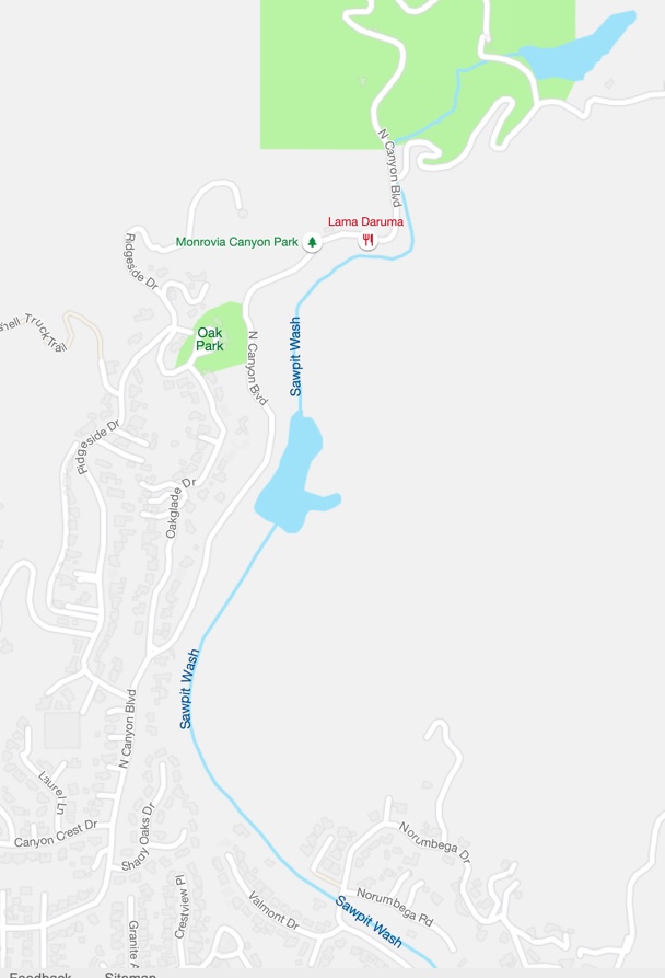
Look at that! Right where the OpenStreetMap indicates a dam, there's a lake.. and even farther north, there's another lake!
After searching for variations on my queries:
[ sawpit debris basin ]
[ sawpit dam Los Angeles county ]
I found this map at the LA County Flood Control district:
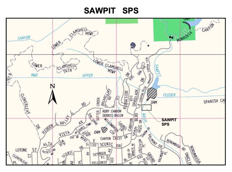
This shows the Sawpit Sediment Placement Site (SPS), the Sawpit debris basin, and the Sawpit dam way up at the north. The northern Sawpit dam is no longer in use (which is why it's not on the list of LA dams), but what looks like a dam (and is marked as a dam in this map), is actually a debris basin.
Basically, a debris basin is a kind of dam often used in areas where there is extensive flash flooding. This mountain range (the Santa Gabriels mountains) are notorious for this. (See John McPhees' book, Control of Nature for more details on this.)
When the rains come and the ground gets soaked, any more rain instantly runs off, bringing a massive amount of boulders, rocks, trees and brush. A debris basin catches most of this junk and has to be cleaned out every once in a while.
A sediment placement site is where the excess water runs (below the debris basin) to let sediment slowly settle out, rather than filling the channel.
Why am I telling you all this?
Because the channel in the first photo shows a kind of ramp leading up from the channel to the surface streets. That exposed gap in the channel wall means that anything coming down the channel will preferentially strike that corner. A corner like that is pretty delicate--it will need a bumper or some kind of protection to keep it from rocky harm.
And why does that matter?
Because this channel buttress is right after the debris basin and before the sediment placement site. When this channel fills up, that particular corner is going to be in for a lot of abuse by rocks and logs and everything that's coming down the spillway from the debris basin.
So while I wasn't able to find out anything definitive about this structure (none of the obvious queries worked!), it seems pretty clear that it's built to handle the stresses of massive water + debris flows coming down from above.
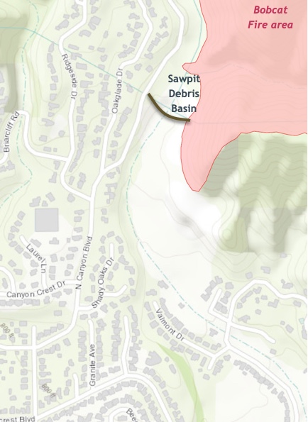
Interestingly enough, the current fire (still in flames as I write this!) is the Bobcat fire, which has burned all of the upstream brush and woodlands. This winter will be a real test for the channel and the buttress.
SearchResearch Lessons
As I said, there are all kinds of ways to think about these SRS Challenges. You could extrapolate the questions: Why aren't all contrails poofy like this? Or, Why does Los Angeles have all of these strange channels that obviously don't have water in them? Assuming that this channel sometimes does carry water, where does that water go? Or you could expand your range of searches to include items that are nearby or potentially relevant. Count on your curiosity to lead you to those new topics.
In these two SRS cases we're left with not-quite-complete answers to the Challenge questions. We have some hypotheses about why some contrails grow lobes, but not a definitive answer.
In the case of the channel buttress, we're left with a good guess based on what we found nearby... but I was hoping for an engineering report or a blueprint to say what it was, how it was designed, and why it's only at that location.
But in both cases my curiosity drove a lot of discovery, and I learned enough about contrails, mammatus clouds, and low non-homogenous clouds to be fairly sure that I understand the lobes. Likewise, I learned about debris basins and the way large amounts of debris flow down channels to be pretty sure that this is what's going on--it's there to protect the relatively weak and exposed corner. Not conclusive... yet... but pretty high probability.
What did we learn from these Challenges?
1. Not all Challenges have neat answers! We've seen this before, but it's worth remembering. I spent about 12 hours trying to answer these Challenges (especially the channel-buttress and debris basin question), but never really got to a conclusive answer. At this point, if I was getting paid for this, I'd call up the LA County Flood Control district and talk to someone. (But I'm out of time for the week.)
2. Look at different maps to get different information. You'd think that all of the maps would have pretty much the same data on them, but that's not quite right. The Bing maps shows exactly where the debris basin is, while the Google map shows different details more clearly. In general, look at more than one map to get a broad perspective on your research. This point generalizes to the contrail challenge as well...
3. Let your curiosity guide you, especially down adjacent topics, but learn as you go. Curiosity is a delicate thing: it can be incredibly productive IF you keep track of the amount of time you're spending following a topic. But you have to be willing to cut the curiosity tangent off when it starts to be unproductive. (That's why I always leave a visible window (or sticky note) with the original research goal on it.) Every 5 minutes or so I see that goal and ask myself, "Is this getting me closer to answering the goal?" If not, I cut off that tangent and go back to my primary task. (Note that it's perfectly okay to change your goal, but if you do that, then change the note!)
4. Take discovery notes along the way. In particular, as you pursue these side tracks in your search, take notes as you go. Write down the special names and terminology, maybe even dates and organizations that might prove valuable in the future. I find that this is a great way to get back to something I ran across once, but then found useful many minutes later. My memory is good, but it needs the metacognitive assistance of notes that capture the good stuff along the way. This skill (recognize the good information) is something that will improve with time. Be aware of it as you do your own search challenges.
Hope you enjoyed this Challenge. I certainly did! (And now I've got a few spare minutes, so I'll keep checking other notes that I didn't have time to follow-up before. I might post an update if I get really great, clear answers!
Search on!
P.S. These topics itch my curiosity something fierce. As I learn more, especially about the effects of the Bobcat fire on the channel, I'll be sure to keep you updated!
September 29, 2020
Searching for images with filetype: on Google?
Yesterday I made an interesting mistake..
I'd seen an animated GIF of a cat. I thought I'd like to see it in detail, so I did what I thought was an obvious search. I did:
[ cat filetype:gif]
on the regular search page. I was VERY surprised when I saw ZERO results! That's funny...
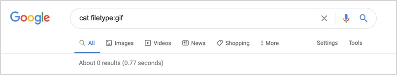
You know and I know there are about a billion images of cats on the internet, so what's going on?
I asked a bunch of friends, all of whom said "that's odd!" Until finally a wise person pointed out that...
... you can't use FILETYPE: on a regular search...
... you have to use Images.Google.com...
Really?
Yeah, Really. Even though the search UI says "All"

Turns out that it's not really "All."
In particular, to find an image, you have to use Images.Google.com. Likewise, if you want to find a scholarly article, you have to use Google Scholar, you can't get it from plain old All search.
So, if you want to see the Google Scholar version of my 1993 paper on sensemaking, you won't find it by searching on regular Google.
I mean, you'll FIND it at a repository such as ACM.org or ResearchGate.net, but regular Google search won't take you to Google Scholar--you have to go there first manually (Scholar.Google.com), and then search there to get to the Google Scholar version of the paper.
Just as with my filetype:gif search, Google's "All" search really means regular web pages, plus a few other kinds of documents--PDF, PPTs, PPTX, XSL, XSLS, KML, KMZ, etc. (Notice that filetype: works for all of those.)
It just doesn't work for JPG, GIF, ICO, TIFF, or other image file types.
Note that if you do a slightly different search, putting GIF in the query, Google will figure out your image-search intent, and give a bunch of images on the SERP. That's a pretty good workaround.
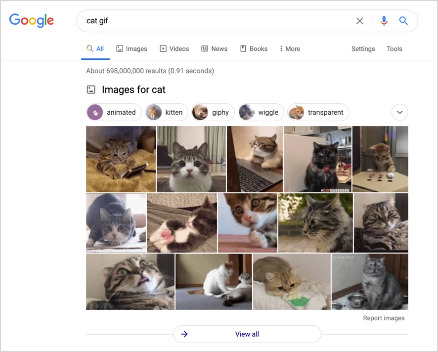
But clicking on any of those images jumps you over to Images.Google.com, where you'll see just what you'd expect, regular old Image search for [cat gif]

Suppose you NOW want to search for a different type of image file--say you'd like JPG files. It's HERE that you can add in the filetype:jpg filter, like this:
You could change that JPG to ICO (icons), or PNG, or GIF, or SVG. They're all different file formats for images. It's here, in Images.Google.com that the filetype operator for image file types will work, not in "regular" Google search.
For example, here's the [ cat filetype:ICO ] search in Images:

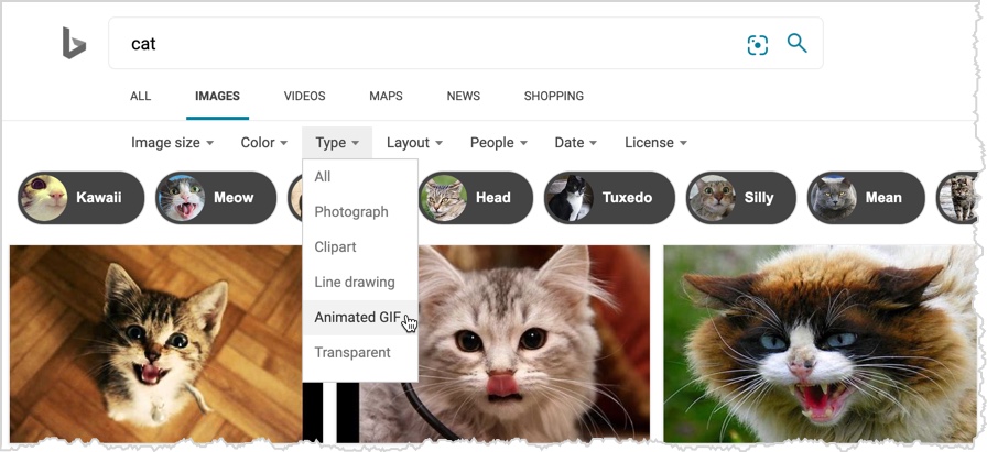
You can search for GIFs on Bing search, but you have to use the Tools option (see below). I don't know of any way to specify the file format type in the query. (For instance, how would you find a non-animated GIF image on Bing? Don't know.)
As someone once said (maybe Issac Asimov?),
"The most exciting phrase to hear in science, the one that heralds new discoveries, is not “Eureka!”but “That’s funny …”
In this case, my that's funny moment was getting zero results for a query that I thought would give me millions. A bit of investigation taught me this important lesson:
FILETYPE: for images only works in Images.Google.com
That's a useful thing to know. Remember, "All" doesn't always mean "ALL."
Search on!
September 25, 2020
Fact check labels in search results
A bit more on fact-checking…
Google puts in a fair bit of effort to surface fact-check information in the results. As you search, be sure to pay attention to the fact-check labels as they’re put on the page to evaluate questionable information. You can read the original Google blog post about it here.
Here's an example of an Image search for the mythical [ black lion ]. Note the red dashed oval I added to the screengrab. Google adds in the "Fact check from AFP Fact Check" (which is one of the partners who verify such things).

This label appears in regular Web Search, News Search, and Image Search. These fact checks and labels come from vetted publishers that use the ClaimReview schema (a way for fact-checkers to annotate content that’s clearly questionable) to mark up fact checks on stories and images.
Here are some examples of fact-check labels when they appear. Since they’re sometimes not obvious, I’ve highlighted them so you’ll spot them next time you run across one in your searching.

Note that News.Google.com has a fact-checking section all the time. (See below--the red dashed box.)

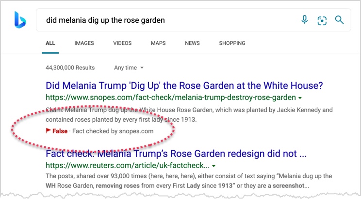
I also want to point out that Bing does a nice job of making their fact-checks very visible. Here, I added the red-dashed-oval, but the red False typography is Bing's.
While we’re talking about fact-checking… I actually much prefer to call this kind of thing “verification,” since the term “fact-checking” presupposes that the assertion you’re trying to validate already is correct. That is, after all, what a “fact” is—an assertion that is assumed to be correct. "Facts" are mostly things that you don't check. Instead, we verify assertions.
That is, verification is the process of testing each assertion for its validity. "The Earth is sphere-like." That's a fact. By contrast consider "The Earth is a large disc floating in space." That's an assertion you probably want to verify, especially since it conflicts with everything else you know about planets floating in space. Going forward, I'll talk about verfication rather than "fact-checking," even though I know it's an uphill battle.
But this reminds me that I'm not alone in this quixotic quest: A great handbook on verification can be found at the DataJournalism.com site (the Verification Handbook, download for free).
Search on!
(With care and your verification lenses fully engaged.)
September 23, 2020
SearchResearch Challenge (9/23/20): Digging deeper into the story behind a photo?
I'm sure this happens to you...
You're out and about when something captures your eye. Quick! Pull out the phone/camera and grab the image. Later, when you get back home, you can look it up. (Usually.)
Recently I took a couple of photos that I've puzzled over for a while. What's going on in these images? Can you help me figure out what the backstory is for each of these images?
These are fun Challenges that can go in many different directions. Where will your curiosity take you?
1. Here's a pic I took the other day in my back yard. I live not too far from San Francisco International airport, so it's common to see contrails in the sky. But this one seems unusual to me. For lack of a better term, it's unusually poofy with lots of blobs along its length. What's going on with these poofs on the contrail? Does this happen often? Is there a name for this phenomenon?
2. Here's another photo I took while hiking on a trail next to a channel in the greater Los Angeles area. I'll spare you from having to extract the lat/long from the photo (it's 34.1628333,-117.9922528). It's not the most exciting trail in the world--it follows along a fairly barren path next to this concrete channel for quite a ways before getting to Monrovia Canyon Park (which is quite nice).
As you can see, for most of its length, the concrete channel has plain square walls. Here, though, there's a kind of angled buttress on one side of one corner of the place where the ramp enters the channel. Why is it there? Why would someone feel the need to build this special buttress?
As I said, there are all kinds of ways to think about these SRS Challenges. For instance, you could extrapolate the questions: Why aren't all contrails poofy like this? Or, Why does Los Angeles have all of these strange channels that obviously don't have water in them? Assuming that this channel sometimes does carry water, where does that water go? (Ultimately, it will go into the Pacific, but where does it stop on the way?
I'm curious about your curiosity. What motivates YOU to take a note or snap a photo for later looking-up? I do it all the time, but I've been led to understand that not everyone does this! Do you? If so, what motivates your curiosity? And how far will you go to figure something out? Does your mind naturally ask just one more question, the way mine does?
After The Joy of Search came out I ran into a friend at grocery store. She told me that "I've been reading your book and now I know a lot about how your mind works. You know, you're not normal..."
I assume she meant that in a friendly way as a comment on my curiosity. I think of my level of curiosity as normal, but it's not a common topic of conversation.
Is your level of curiosity normal? What do you think? What motivates you to pursue SRS-like investigations in your life?
Please leave your comments in the blog comments area. And, as always, let us know HOW you found the answers to these Challenges.
Search on!


