
Matthew Houde's Blog, page 26
December 22, 2016
Atenas: A Glimpse of Authentic Costa Rica
Two Weeks in Costa Rica |
Not far from the bustling city of San Jose you will find the charming town of Atenas. This medium-sized town in the Central Valley offers a glimpse at local life. From a bench in the picturesque central park or over coffee at a local restaurant, you can see Costa Ricans in their daily life. While Atenas isn’t exactly on the tourist trail, it has drawn many expats over the years due to its favorable climate and offers visitors several interesting things to do. Below, we’ll share more about this local town and why you might want to add a stop on your next visit to Costa Rica.

About Atenas
Atenas is located about 45 minutes west of the city of San Jose and about a half-hour from the international airport in Alajuela. Although it is close to urban areas, Atenas itself couldn’t be more different. The town is surrounded by rolling green hills, speckled with rows of coffee plants and sugarcane. Just a short drive from these quiet barrios (neighborhoods) is the central area of town, which has a lot going on. Here, you will find many restaurants, grocery stores, shops, and other conveniences. The downtown is the hub of local life, with a scenic park and church as the focal point.
A couple of things that make Atenas noteworthy are its climate and coffee. The town is said to have one of the best climates in the world, with average temperatures in the mid-70s°F (21°C) year-round. The climate, combined with the area’s rich volcanic soil, also makes Atenas an excellent location for coffee production. Many of the producers you will find are small, family-run operations and there are even some that you can tour (more on this below). Interestingly, Atenas was located along the original oxcart trail. This route was used in the late 1800s to transport coffee beans from the Central Valley to ports on the Pacific and Caribbean coasts for export. Various references to the oxcart trail can be seen around town. One notable example is the monument of a boyero, an oxcart driver, about a kilometer east of downtown.
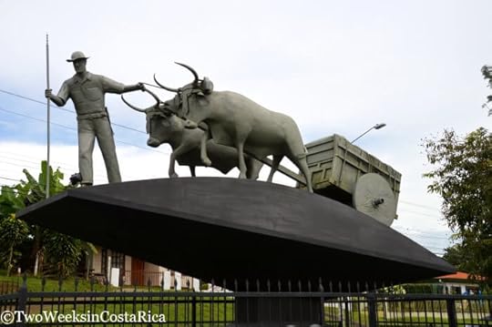
National Boyero Monument on Route 3
Activities
You can spend hours just soaking up the local culture in the downtown, but here are some other ideas for things to do.
El Toledo Coffee Tour
If you’re visiting Atenas, a coffee tour is a must. El Toledo is a small coffee farm owned by a Costa Rican family. They are one of the few growers in the country to go completely organic. On a tour of the family farm, you’ll learn from the passionate farmers themselves about the importance of biodiverse coffee production and, of course, see how it is made from plant to cup. The tour ends with a tasting of El Toledo’s three different roasts. We really enjoyed this coffee tour because it is so personalized and non-commercial. $20 per person.
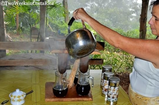
The chorreador or “sock” method of brewing allows the delicious oils of the coffee to come through.
Farmers Market
Many communities in Costa Rica have a farmers market and Atenas is no exception. Every Friday, both locals and expats gather to shop and chat about local happenings. Under the newly built, modern structure, you will find an assortment of produce as well as baked goods, artisanal products, coffee, souvenirs, and even flowers. A local bus runs to and from the center of town for free if you don’t have a car. Click for a map with the location.
Las Minas Waterfalls
Just 20 minutes outside Atenas is a set of secluded waterfalls. Las Minas Waterfalls (The Mines Waterfalls) is located in the village of Desmonte. This set of waterfalls and swimming holes is so named because of an old gold mine in an upper area of the river. Although this spot is located deep in the country, it is not hard to find with good directions.
Take Highway 3 west out of Atenas. At a flashing yellow light, take a right (look for the restaurant Chicarronera El Minero). Follow the windy road for about 1.5 miles (2.4 km), staying left at two forks. The road turns to dirt, then back to paved, but wasn’t in bad shape even in the rainy season. When you get to a large bridge, you have arrived at the parking area. Here’s a map with directions. Don’t leave anything valuable inside your car.
To get to the pools upriver, you will have to walk along the riverbed, up over large boulders and through water, depending on the season. Sturdy boots or sandals like Keens are best. This isn’t a recommended hike for everyone. Jenn had to stay behind with our one-year-old son because the rocks were too tricky.
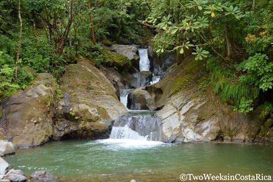
The upper set of falls at Las Minas Waterfalls is harder to access but worth the effort.
Botanical Orchid Garden
If gazing at hundreds of beautiful orchids is more your speed, check out the Botanical Orchid Garden in nearby La Garita. This outdoor garden cultivates orchids in a lab setting and lets them propagate in the wild on their property. The different nurseries have orchids in all stages of growth, allowing visitors to learn about the complex life cycle of these interesting plants. The property also has paths through the forest that showcase local trees and host a variety of birds. To learn more about visiting the Botanical Orchid Garden, including the best times of year to go, read our separate post.
Train Museum (Museo Ferroviaro Rio Grande)
In nearby Rio Grande, you can visit a historic train museum. This isn’t a huge attraction, but if you have a free hour, it is interesting to learn about the old railroad that ran from San Jose to Puntarenas. The small museum at the train station houses photos and artifacts like generators, radios, railway parts, and devices used for Morse code. The attendant will also take you up inside the old engine car for some great photo ops. Those wanting to explore can walk the tracks over the Grande River. Open only on Sundays. Click for a map with the location.

Our little guy playing conductor at the train museum
Zoo Ave
If you have children, Zoo Ave is a wonderful stop. This wildlife center rescues and rehabilitates animals that have been injured, orphaned, or confiscated from the illegal pet trade. Some examples include Scarlet Macaw parrots, white-faced monkeys, and even a few species of jungle cats. If animals are unable to be released back into their natural environment after being treated, they live the rest of their lives on the property. One notable inhabitant is a toucan named Grecia that lost most of her beautiful beak in an abusive incident. Grecia now shows off a one-of-a-kind, high-tech prosthetic beak along the trail at Zoo Ave. $20 per person.
Restaurants
Atenas doesn’t have a big restaurant scene but there are some delicious options.
Pizzeria La Finca
Whenever we’re passing through Atenas, we always seem to end up at Pizzeria La Finca. The comfortable outdoor dining area and delicious wood-fired pizza, flatbreads, and bruschetta are obvious draws. They also have craft beer on tap. We recommend the locally brewed El Granero alongside the prosciutto, tomato, arugula, and fresh parmesan pizza.

The delicious wood-fired pizza at La Finca
Etnia
Etnia is tucked away off the main road and offers contemporary food in a trendy environment. The menu changes regularly, but we loved our chorizo-beef burger with blue cheese and apple and hummus plate. This is the place to go if you’re looking for a little more ambiance in your dining. Etnia is open on weekends only (Friday to Sunday) and often has live music.
El Café de la Casa
For excellent typical Costa Rican food, head to El Café de la Casa. This tiny, charming restaurant occupies the porch area of a historic building in downtown. The menu is small, but you will find classic casados for lunch (plates of meat or fish with rice and beans and side salads) and a rotating daily special. The Olla de Carne on Wednesdays is delicious! Afterwards, be sure to stroll over to check out Jonathan’s handmade jewelry next door.
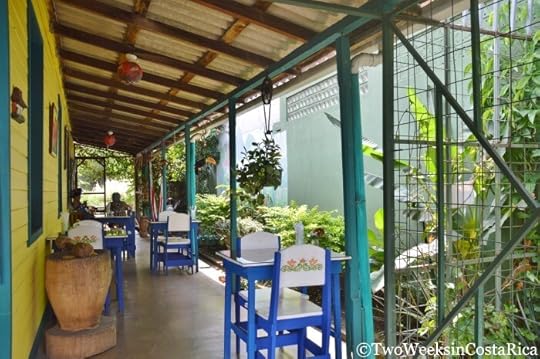
The quaint porch dining area at El Café de la Casa
El Balcon de Café
This German-owned café and bakery is one of the most popular restaurants in Atenas and for good reason. Breakfast and lunch items are fresh and made with quality ingredients that you won’t find everywhere in Costa Rica. At El Balcon de Café, they use their homemade bread throughout the menu. We recommend taking a loaf of the potato bread home. The house specialties like schnitzel and goulash are delicious too.

The German breakfast at El Balcon de Cafe
La Casita del Café
For one of the best views around, head to La Casita del Café. This simple Costa Rican restaurant at the top of the hill on Route 3 has fantastic valley and even ocean views when conditions are right. Go for breakfast and arrive before the clouds roll in. The food is good, nothing fancy, but the scenery more than makes up for it.

An early morning view at La Casita del Café. You can see the ocean in the distance off to the right.
Kay’s Gringo Postres
Kay’s Gringo Postres is a well-known expat hangout hidden outside downtown. If you’re interested in moving to Atenas, this is a good place to get the dish on what it’s like to live there. Delicious homemade desserts and cookies are available, plus a full breakfast and lunch menu. The breakfast buffet on Sundays is also popular.
La Trocha del Boyero
La Trocha del Boyero is a Tico-owned restaurant in a quiet neighborhood outside town. Surrounded by lush greenery, you can enjoy upscale typical Costa Rican food from their outdoor dining area. They have a variety of meat and seafood dishes, but their specialty is sea bass with sauce. The food here is solid, but what makes the experience is the friendly owners. Portions are big so come with an appetite.

The filet mignon at La Trocha
Restaurante Antaño
Located in an old colonial building in downtown, Antaño is another expat favorite. The menu features typical Costa Rican dishes served by friendly wait staff. The environment is very comfortable, making it a good choice for just about anyone.
Accommodations
Atenas has a small selection of cabinas and bed and breakfast-style lodging, as well as a number of vacation rentals. Here are our picks for places to stay. Don’t miss the promo code for Two Weeks in Costa Rica readers, below, to save on accommodations!
Casa Doughty
Casa Doughty is a gorgeous vacation rental just a short drive from town. With 5 bedrooms and 3 bathrooms, it is a great option for a group or a couple of families traveling together. The house has a spacious, fully-equipped kitchen and comfortable living area. The outdoor space is well manicured with flowering plants and local fruits, and there is a comfortable pool area to relax. The property is set high on a hill so has a fantastic view of the mountains and Central Valley. At night you can see the lights of San Jose in the distance. We stayed here recently and loved having all the space. $120-175/night.
The owners of this rental also own a beautiful 4 bedroom house in the Pan de Azucar area of Atenas. To book either home, contact them through their website. Mention Two Weeks in Costa Rica to save 10% on your entire stay!

The beautiful finishes inside Casa Doughty
B&B Vista Atenas
This charming B&B is located only about 10 minutes from town, but in a quiet, peaceful location. As the name implies, B&B Vista Atenas also enjoys outstanding views of the Central Valley, especially from the pool. Rooms are bright, clean, and comfortable, and the staff here is friendly and welcoming. $50-70/night. Check Rates and Availability Here.
Apartamentos Atenas
Apartamentos Atenas is a group of five cabins set around a small pool. The cabins are nicely spread out, allowing for plenty of privacy, and are surrounded by lush gardens. This hotel is a good pick if you’re looking for a scenic place to overnight around San Jose, but is also set up for longer stays. Each unit has a kitchenette with all the basics. The owner told us that she hosts a lot of people who are interested in moving to the area and many returning visitors as well. $50-70/night. Check Rates and Availability Here.

The outside living area of our cabin at Apartamentos Atenas
If you’re looking to experience a bit of authentic Costa Rica, check out Atenas. This town not only offers a taste of local life, but also has a lot of interesting attractions. With coffee tours and waterfalls, Atenas is a nice break from the beach or a fun diversion on your way to or from San Jose.
Have you visited Atenas? What did you think? Leave us a comment below (Email subscribers, click here to post your comment online.)
Some of the links in this post are affiliate links. If you book a hotel using one of the links, we receive a small commission at no extra cost to you. Read our Privacy Policy for more information.
Looking for more information about Costa Rica? Check out these posts:
Costa Rica Rental Car Discount – Because Atenas is more spread out, it is best explored with a rental car. Check out our discount through one of the major companies in Costa Rica to save 10-25%.
Monteverde: A Forest in the Clouds – If you’re continuing on to Monteverde after your time in Atenas, this guide will help you get the most out of your visit to the misty cloud forest.
Life in Costa Rica – If you’re considering a move to Atenas, you’ll want to read posts from our Life in Costa Rica section to know what to expect.
The post Atenas: A Glimpse of Authentic Costa Rica appeared first on Two Weeks in Costa Rica.


December 7, 2016
The Famous Monteverde Cloud Forest Reserve
Two Weeks in Costa Rica |
Monteverde has several reserves to take in the area’s abundant nature, but one of the most popular is the Monteverde Cloud Forest Reserve (Reserva Biologica Bosque Nuboso Monteverde). This reserve offers a variety of trails and has several characteristics that make it unique. Most notably, it is positioned at the location of the Continental Divide where the Atlantic and Pacific slopes collide. The Reserve is also known for its red hanging bridge, which you see in all of the pictures. In this post, we’ll tell you what you need to know to plan your hike to this famous reserve, including ways to avoid the crowds.

History of the Reserve
The Monteverde Cloud Forest Reserve was established in 1972 after a scientist named George Powell who was visiting the area became concerned about conserving Monteverde’s rich biodiversity. Settlers were moving into the forest, and widespread hunting was jeopardizing the rich flora and fauna. Determined to make a difference, Powell reached out to a local man named Wilford Guindon, one of the first Quakers to arrive in Monteverde. Together, the two promoted the establishment of a nature reserve, which came to fruition with the help of the Tropical Science Center.
The Reserve was started with a donation of 328 hectares (820 acres) of land. The Tropical Science Center quickly expanded that by soliciting donations from individuals and conservation organizations around the world. Included in the list of donors were some prominent names like the World Wildlife Fund, Nature Conservancy, and International Council for Bird Preservation (BirdLife International). Over time, the Reserve was expanded with the help of Guindon and others to include adjoining areas that were being threatened by development. An interesting event happening in the background at this time was a 1977 BBC documentary. This film about Monteverde’s cloud forests dramatically increased interest in the region, and in particular, the preservation of tropical rainforests.
Today, the Monteverde Cloud Forest Reserve encompasses an impressive 10,500 hectares (25,946 acres).
What You’ll See
Four different life zones exist on the massive property, each with a slightly different ecosystem. It is this diversity that draws so many different types of plants and wildlife. To get an idea, over 100 kinds of mammals, 500 birds, and 120 amphibians and reptiles can be found. In addition, the property hosts tens of thousands of insects and over 3,000 plants, including more than 500 species of orchid alone.
Some of the more common animals seen are white-faced and howler monkeys, paca and agouti (small rodent-like animals), and coati (similar to a raccoon). As we mentioned, bird species are numerous here as well. Hummingbirds are plentiful and you can also spot the Three-Wattled Bellbird. One of the biggest draws for birders, though, is the Resplendent Quetzal. This brightly colored bird with extraordinarily long tail feathers can be seen in only a few parts of Costa Rica. It spends much of the year in Monteverde but is easiest to spot in March and April during their breeding season.
Tip: To see the most, hire a guide. Although Monteverde is one of the most biodiverse areas of Costa Rica, wildlife is often hidden high in the canopy or in the shifting clouds. A good guide not only knows where to look, but also has a scope, allowing you to see things up in the trees.

This white-faced monkey was very hard to spot, camouflaged in the thick canopy
Even with a guide, there is still a possibility that wildlife will remain mostly hidden at the Monteverde Cloud Forest Reserve. Luckily, though, walking along the trails is a unique experience in itself due to the climate and landscape. The Reserve is at a very high altitude and you will often pass through thick clouds shifting in the wind. The trees and plant life are also unlike anywhere in Costa Rica. Thick moss and lichens cover every inch of bark and rock, and broad-leaf plants, vines, and bromeliads practically grow on top of one another.
An orchid splashing color in Monteverde’s green forest
Trails
To protect the Monteverde Cloud Forest Reserve’s abundant flora and fauna, only a small portion (about 3%) of the property is open to the public. Still, the Reserve’s nine trails amount to 13 km (8 miles) of path to explore. Here is a link to the trail map.
There are several different options for hikes, but below we cover the two main loops.
Longer Loop
This is a good choice for a hike if you have about a half day to spend. The loop goes around the perimeter, starting on Sendero Bosque Nuboso (Cloud Forest Trail). Sendero Bosque Nuboso leads through thick cloud forest and is supposed to be one of the best places to spot the elusive Resplendant Queztal bird.
The trail ascends, and in about an hour, you will reach a lookout called La Ventana (the Window). Here, you will find a beautiful view of the Continental Divide, the point where the Atlantic and Pacific slopes converge. Seeing the moisture-rich trade winds of the Atlantic slope collide with warm air of the Pacific slope was one of the most memorable parts of our visit to the Reserve. Although the clouds were racing by, we managed to catch quick glimpses of the beautiful valley below.

View of the Continental Divide through a haze of clouds
From the viewpoint, you continue on Sendero Pantanoso (Marshy Trail) to Sendero El Rio (River Trail). This was our favorite part of the hike because the trail ran along a steep ridge, putting us at canopy level with many of the treetops. From this vantage point, it was a lot easier to see wildlife. Though it was still sometimes difficult to see through the thick haze, we did manage to spot a white-faced capuchin monkey, a mother and baby white-nosed coati, a gigantic snail, a small land crab, and lots of interesting insects, as well as several types of birds, including wrens, warblers, and thrushes.
Mid-way through Sendero El Rio is a short path that leads to a waterfall. It is small but still very pretty.
Plan on spending about a half day for the longer loop so that you can go slowly and look for birds and wildlife. The trails are well maintained, but still rustic in places. Conditions were moderate in difficulty with some steeper spots and rocks and roots to navigate.
Shorter/Main Loop
This is the most visited and busiest loop. Sendero Camino (Road Trail) is wide like a road and leads to the hanging bridge. After doing the long loop, we weren’t sure we wanted to do the main one, but were glad we did. The hanging bridge was really beautiful and worth the stop. From high atop the swaying bridge, we had an even better view of the overflowing canopy than we did on the River Trail.

Looking down at the treetops from the hanging bridge
From the hanging bridge, you can connect back to the ranger station by taking Sendero Wilford Guindon, named after the prominent conservationist who helped found the Reserve. This trail is narrower and more scenic. On our visit, we saw some birds and a coati, which was a nice surprise.
The main loop takes about 1.5 hours. Sendero Camino is one of the easier trails in the Reserve. Sendero Wilford Guindon is more difficult, with some steps, so take Sendero Camino both ways if you’re looking for something easier.
Planning Your Visit
Hours
The Monteverde Cloud Forest Reserve is open daily from 7 a.m. to 4 p.m.
Admission
Foreigners – $20. Citizens and residents – $7. Half-price for children six to 12. Children under six free. Discounts provided for students with valid ID. See the Reserve’s website for more information.
Guided Tours
The Monteverde Cloud Forest Reserve offers a variety of guided tours, including a birdwatching tour, natural history tour, and night walk. Visit their website to make a reservation or for more information.
Cafeteria and Gift Shop
If you need a hot drink or snack, the Reserve has a restaurant and cafeteria. There is also a gift shop, which has some interesting souvenirs and a good assortment of nature guides.
When to Visit
The Monteverde Cloud Forest Reserve is one of the busiest areas of protected land in town. It often gets busy, with busloads of visitors looking to discover the cloud forest. Avoid peak travel times like Christmas and New Years to avoid the biggest crowds. The rainy season, May to November, sees the fewest visitors. The rainiest month in Monteverde is October.
What to Wear/Pack
The average temperature in Monteverde is 65.8°F (18.8°C), and it often feels cooler due to the moisture. We recommend layers and lightweight long pants. A poncho or raincoat is also a necessity as rain is frequent in the cloud forest. For footwear, hiking boots or sturdy sneakers with good grips are best. If you are planning a long hike, it is also wise to invest in an inexpensive backpack cover in case of a heavy downpour. Check out our post on packing your daypack for more tips on what to bring.
A section of trail within the Reserve
Out of all the nature reserves in Monteverde, the Monteverde Cloud Forest Reserve is one of our favorites. The trails are not only scenic and rugged, but also offer interesting viewpoints. We enjoyed seeing the canopy from the hanging bridge and especially loved the view of the Continental Divide.
Have you visited one of Monteverde’s nature reserves? Share your experience below (Email subscribers, click here to post your comment online.)
Want more info for your trip to Monteverde? Check out these posts:
Monteverde: A Forest in the Clouds – Monteverde has a ton of options for hotels and activities. Our destination guide will help you figure out the best places to stay and things to do.
Costa Rica Rental Car Discount – The Monteverde-Santa Elena area is more spread out so it is nice to have a rental car to explore. Save on a sturdy 4×4 with our special discount.
Driving to Monteverde – Yes, you’ll need to take some dirt roads to get to Monteverde but most people find the drive to be manageable. Read our guide to learn the best routes and see videos of actual road conditions.
The post The Famous Monteverde Cloud Forest Reserve appeared first on Two Weeks in Costa Rica.
November 24, 2016
Wilson Botanical Garden at Las Cruces Biological Station
Two Weeks in Costa Rica |
Costa Rica is said to hold as much as five percent of the world’s total biodiversity. For such a small country, that means that around every corner you can see dozens of unique plants and animals. Imagine now, a meticulously planted botanical garden with vegetation not only from Costa Rica, but around the world. The Wilson Botanical Garden near San Vito is just that. We recently made a visit to this internationally recognized garden, and in this post, give all the details to plan your own trip.

History of the Garden
The Wilson Botanical Garden was first established by Robert and Catherine Wilson in the early 1960s. The couple moved to southern Costa Rica in 1962 from Miami, Florida where they operated a tropical nursery. Upon their arrival, the property where the gardens are now, near San Vito, was nothing but abandoned coffee fields and cattle pasture. Along with their plans to cultivate tropical plants, the two originally had hopes to start a tea farm. The effort and cost to process the tea leaves, however, soon thwarted that idea. Instead, using their skills in horticulture and the design knowledge of a friend (famous Brazilian architect Roberto Burle Marx), an impressive tropical garden began to take shape.
In 1973, the Wilsons sold the property to the Organization for Tropical Studies (OTS) and remained on as managers for a number of years. The OTS is a non-profit consortium of research institutions and universities. Its mission is to provide leadership in education, research, and the responsible use of natural resources in the tropics. In addition to the 25 acres (10 hectares) that make up the Wilson Botanical Garden, over the years OTS acquired more land that borders the property. They now own about 806 acres (326 hectares), which, including the Wilson Botanical Garden, make up Las Cruces Biological Station.
As the Wilsons aged, the OTS became more involved with the gardens but kept the Wilson name to honor of their efforts. The couple is buried on the property outside their former home. Today, the home is used to house research students who share the same enthusiasm for horticulture as the couple once did.
Beautiful orchids near the grave site of Robert and Catherine Wilson
What You’ll See
The main attractions for visitors to the Wilson Botanical Garden are the elaborate plant collections. Over 3,000 different species of exotic plants can be seen through a network of meandering garden paths and trails. Additional forested trails bring you through farther reaching sections of Las Cruces Biological Station. We’ll talk about both below.
The Gardens
The elaborate gardens are broken up into sections. Each features a different genus of plant with some crossover and additional species, like large trees, mixed in. Mostly, though, you will find areas of similar plants and see various plaques or tags identifying their scientific names. In the past, the gardens have been used mainly for scientific research so aesthetics wasn’t the priority. Recently, though, a new director has been initiating changes to make the gardens more appealing to everyday visitors. Flowering species are being added to areas that previously held only leafy vegetation, and a new hummingbird garden has been constructed. The hummingbird garden is built in a Japanese style, and while still in the early stages of growth, is quite beautiful already.
Those walking through the gardens will pass through the following sections. Click here to see a map.
Tree Ferns and Palms
The Wilson Botanical Garden has the second largest collection of palm trees in the world with 700 species.

Part of the palm tree collection
Marantas
Common as houseplants (e.g., prayer plant), this genus is known for low-growing lush and colorful leaves.
Bananas
Bananas aren’t always yellow. Some of the species in the gardens have beautiful reddish fruits or elaborate flowers.

Colorful banana flowers
Heliconias
Sometimes referred to as parrot flowers or lobster claws, these plants have interesting shaped flowers that allow only certain hummingbirds with curved beaks (like the green or brown hermit) to eat their nectar.
Dracaenas
A common genus to Africa. Also a popular houseplant.
Bamboos
There is a massive section of bamboo with 63 different species. Fifteen of the species are indigenous.

One of the paths cutting through the bamboo grove
Gingers
Many of the ginger species have beautiful flowers. Our favorite is the beehive ginger, which has a waxy looking sort of honeycomb flower that is yellow, red, or a mixture of both.
Aroids
Occasionally referred to as philodendrons, these plants have interesting flower parts. Something called a spadix (picture a narrow corn cob) is usually centered on a spathe (leafy part of the flower).
Bulbs, Conifers, and Rhododendrons
This section of the garden, adjacent to the Wilson’s former home and grave site, has some mature conifer trees with nice beds of rhododendrons and bulbs beneath. There is also a picnic area and benches to take a rest.
Cycads
Sometimes mistaken for palm or fern species, cycads are ancient, slow growing seed plants with woody trunks and evergreen leaves. Though not as common these days, during the Jurassic Period, these plants were some of the most prolific.
Bromeliads
Bromeliad Hill, where the Wilsons are buried, is one of the more manicured areas of the property. A signature design method of Architect Roberto Burle Marx can also be found here. Look for the ruffled fan palm (Lacuala grandis) planted beside an imperial bromeliad (Vriesea imperialis).

Bromeliad Hill
Forest Trails
In addition to the garden paths, Las Cruces Biological Station has seven trails that stretch over 12 km (7.5 miles). Trails range in difficulty from easy to hard and cover a range of distances from only 0.5 km (0.3 miles) to 3.1 km (2 miles). Be sure to ask for a map of the forest trails, which has a lot of detailed info about the specific conditions.
Close to 200 hectares (494 acres) of the property are classified as primary (virgin) forest so the landscape is quite different than that of the gardens. Here, you’ll find towering canopy trees and understory vegetation native to Costa Rica. There is also ample opportunity to view wildlife. Almost 300 species of birds and 3,000 species of butterflies and moths have been identified!
On our visit, we took the very short Rio Java Trail to the canopy tower to do some birdwatching. We then backtracked into the gardens and cut through the bamboo grove to connect with the Jungle Trail. The shorter section of the Jungle Trail returned us to the botanical gardens for a total hike of about 40 minutes (going slow). This hike was easy to moderate with some slippery areas to traverse. The Jungle Trail also loops around another way, which would make the hike about an hour longer.
The Canopy Tower was probably the highlight of our hike since from the top you have an outstanding view of the forest and mountains. This tower is 15 meters (49 feet) and has vegetation of various heights surrounding it, which is great for birdwatching. We spotted a Blue-Gray Tanager and some Green Honeycreepers during our brief visit.
View from the canopy tower
On the Jungle Trail, we also saw a group of Crested Guans posing on a branch. We didn’t see much for mammals on our short hike, but did see several agouti (small rodents about the size of a rabbit) along the garden paths.

Crested Guans along the forest trails
Planning Your Visit
Hours
The gardens are open daily from 7:00 a.m. to 5:00 p.m.
Self-guided Walk
$8.00 Foreigners, $1 Nationals or Residents
Guided Tours
Guided tours include garden walks, hiking, birdwatching, night walks, and more customized tours. Individual or group rates are available. All are by reservation only. Email: nat-hist@ots.ac.cr or call (506) 2524-0629.
Directions
From the main intersection in San Vito, take Route 237 toward Ciudad Neily for 6 km (3.7 miles). The entrance will be on the right.
Accommodations
Las Cruces Biological Station has a total of 12 cabins. Rates start at around $95/per person and include meals and one tour (discount for children and additional people).
Another option nearby, which we really enjoyed, is Cascata del Bosco. This small hotel has four uniquely round cabins that are beautifully decorated and cozy. The cabins look out to the forest for some good birding opportunities, and you can also explore the private trails. The restaurant on-site has amazing wood-fired food.

Birding from your porch at Cascata del Bosco
If you are visiting southern Costa Rica and are a plant enthusiast, don’t miss an opportunity to visit the impressive collections at the Wilson Botanical Garden. In addition, the surrounding area is beautiful and the town of San Vito is very welcoming to tourists.
Have you visited the Wilson Botanical Garden and Las Cruces Biological Station? Leave us a comment below. (Email subscribers, click here to post your comment online.)
Looking for more information to plan your visit to Costa Rica’s Southern Zone? Check out these posts:
San Isidro de El General – If you’re on your way to San Vito from San Jose, consider this authentic Tico city as a stop.
Crossing the Rio Sereno Border – If you’re an expat needing a visa renewal, visit the Wilson Botanical Garden and get your stamps at this tranquil border crossing nearby.
Puerto Jimenez: An Outpost to the Osa – If you like to avoid the crowds, you might enjoy this former gold mining town on the Osa Peninsula with easy access to Corcovado National Park.
The post Wilson Botanical Garden at Las Cruces Biological Station appeared first on Two Weeks in Costa Rica.
November 10, 2016
Manuel Antonio Restaurant Guide
Two Weeks in Costa Rica |
Deciding where to eat in Manuel Antonio can be overwhelming. With almost 75 restaurants tucked away in town and dozens more in nearby Quepos, knowing where to get a good meal isn’t always easy. We have been fortunate to live near Manuel Antonio for a couple of years now and eat there often. If you’re visiting, you will be happy to know that the food and overall dining experience is one of the best in Costa Rica. This guide covers some of our favorite restaurants in Manuel Antonio.
Note: All directions are given as if you are coming from Quepos.

Best Restaurants in Manuel Antonio
La Luna Restaurant at Gaia Hotel and Reserve
For fine dining and first-class service, head to La Luna Restaurant at the luxury Gaia Hotel. You will be whisked away by friendly hotel staff on a golf cart to the plush open-air restaurant on top of the hill. Enjoy a gourmet dinner or get the experience for less with a happy hour cocktail and tapas in the lounge (4-6 p.m.). Our favorite is the pineapple-jalapeno margarita. Located 2 km (1.2 miles) from downtown Quepos, left side of road after Hotel Plaza Yara.
Rafael’s Terrazas
Rafael’s Terrazas is a friendly, locally owned restaurant that serves upscale Costa Rican cuisine. The lunch menu has sandwiches, salads (the fresh tuna salad is recommended), seafood dishes, ceviche, and pasta. The dinner menu has more refined dishes that incorporate sauces like Mahi-Mahi in lemon and tuna in ginger-wasabi. The ocean view at Rafael’s is outstanding and we’ve even seen whales breaching while dining. This casual spot is kid and dog friendly. Set back from the road after La Cantina Restaurant on the right.

Seafood Pasta at Rafael’s Terrazas
Marlin
Manuel Antonio doesn’t have a lot of options for dining near the beach, but Marlin is a good one. This open-air restaurant serves traditional Costa Rican dishes like casados and fried snapper, but also has American classics like sandwiches, burritos, and fish tacos. Marlin is a popular spot during the day with people relaxing with a cool beverage after soaking up the sun or walking in the national park. Places come and go, but this restaurant has been around for a long time. Directly across from the main beach in Manuel Antonio.
Barba Roja
One of our favorites in town is Barba Roja. Barba Roja has been in Manuel Antonio since 1975. Even in the low season, this chill restaurant/bar is a fun spot to hang out. Both tourists and locals come for the delicious food and good vibes. The menu, which has been recently updated, includes smoked ribs, sushi, and fresh fish dishes. Tuesdays are still big with 2-for-1 burgers and live music. Sunset is spectacular as well, as the restaurant sits high on the hill. At the top of the hill, across from Economy Rent a Car and right before the road to Hotel Mariposa.

El Wagon
If you have hit your limit on rice and beans, check out El Wagon for excellent wood-fired pizza. Costa Rica isn’t known for its pizza, but this is a go-to spot for many pizza enthusiasts we know. The Diavola with peppers, chorizo, and salami is a favorite, or try the El Wagon with mushrooms, onions, peppers, ham, and pineapple. After El Avion Restaurant on the right, on the way down the hill towards the beach.
El Patio de Cafe Milagro
Cafe Milagro is a longtime favorite in Manuel Antonio. Milagro specializes in gourmet coffee and roasts its own beans, but it’s also a wonderful spot for a meal. For breakfast, head to their lush outdoor dining area for an omelet or banana pancakes. For dinner, savor one of their meat or fish dishes and enjoy live music while sipping a local craft beer. Open all three meals. Vegetarian and gluten-free friendly. At the top of the hill across from Los Altos Resort and the road to Hotel Mariposa.

The comfortable garden patio at Cafe Milagro
Ronny’s Place, Restaurante y Mirador Mi Lugar
This open-air restaurant situated on a peninsula overlooking the ocean has one of the best views of sunset around. You have to work a little to get there, but the vista, fun atmosphere, and good food at Ronny’s Place are worth it. As you’re driving up the hill, look for Amigos del Rio rafting and kayaking company on the left. Take a right and follow the bumpy dirt road for 800 meters.
Emilio’s Cafe
Emilio’s is an eclectic cafe with gorgeous ocean and jungle views. While it is open for all three meals, we recommend it for breakfast or lunch so that you can take in the scenery. The food here is fresh and simple. For breakfast, the eggs benedict and brioche French toast are popular, and for lunch, people love the sandwiches and curry dishes. Homemade baked goods go great alongside their rich coffee. Often has jazz or Latin music. Located right before Hotel Mariposa on the road leading to Punta Quepos.

Tuna Burger at Emilio’s Cafe
Pizza Pata
Pizza Pata is a super casual spot for a quick bite or delivery. Their rectangular pizza is sold by the meter and comes with yummy dipping sauces like pesto and spicy oil. Next to Sancho’s Taqueria and across from the soccer field.
El Avion
If you’re wondering why a US military plane sits as if it crashed into the hillside of Manuel Antonio, you’re not alone. The story behind El Avion can be found on the back of their menu and reading it is a good excuse to sit down for some good food and drink. Before you leave, make sure to take some selfies in the plane’s cockpit, which is also the bar. This is the perfect place for the whole family, with a large menu and kid-friendly options. On the right after Hotel Villa Roca.
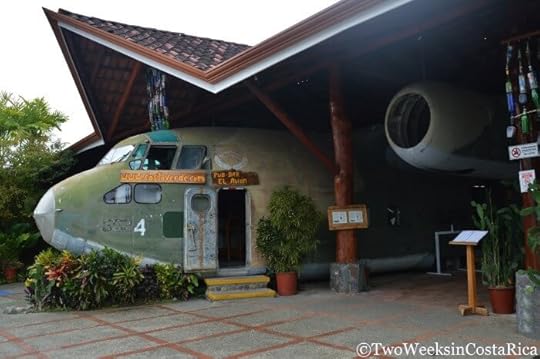
The old military plane at El Avion is hard to miss on the main road in Manuel Antonio.
Restaurants at Marina Pez Vela
The new marina in Quepos opens up even more opportunities for fabulous food. One of the most popular restaurants at this seaside locale is Z Seafood. As the name implies, Z offers seafood dishes, but also homemade pasta and mouthwatering steak. The food feels sophisticated and so does the modern dining area. For something more laid back, there’s the Runaway Grill where you will find fishermen tipping back a beer after a day out on the water. From their balcony overlooking the ocean, you can enjoy great burgers, sandwiches, apps, and mains. Runaway also hosts a live radio broadcast of Radio Dos on Thursday evenings with updates on fishing conditions and local events.
Sunrice recently occupied one of the vacant spaces at the marina and is quickly making a name for itself. It serves healthy Asian food, and we have heard from friends who lived in this region of the world that it is the best around. Finally, Gabriella’s is popular for a fine dining experience. And of course, don’t forget to end your meal with a sweet treat from Gelateria Amorosi – we can never resist! The marina is in Quepos on the southern end of town.
If you need a ride, the marina has a shuttle that runs to the hotels in Manuel Antonio for free. Just ask your hotel to make the arrangements.

Z Gastrobar at the Marina
Mar Luna
A Costa Rican friend recommended Mar Luna on one of our first visits to Costa Rica for a romantic night out. Mar Luna delivered. This rustic restaurant isn’t fancy by any means, but the warm wooden decor, candlelight, and majestic ocean view is guaranteed to set the mood. Don’t leave without sampling the seafood; it’s their specialty. After Hostel Vista Serena on the right.
Gondola Gourmet Restaurant
Gondola Gourmet is known for its authentic Italian food. They offer meat dishes like stuffed chicken and lamp chops, but the homemade pasta is the highlight. Portions are a little small considering the high price tag, but you can always get dessert. At Plaza Yara Hotel, on the left after Hotel Mono Azul.

Spaghetti with porcini mushrooms, gorgonzola, tomatoes, and basil at Gondola Gourmet
Brooklyn Bakery
Head to this chill cafe in downtown Quepos for the best breads and baked goods on the central Pacific coast. The welcoming expats who own the Brooklyn Bakery take their work seriously. You can see their love for good food in their hearty sandwiches, chewy bagels, and mouthwatering cakes. Next to the Gran Escape Restaurant in Quepos.
Restaurant Junior and Soda Sanchez
Quepos has many casual sodas (local restaurants) to choose from that will give you a taste of the culture. But for the best typical Costa Rican cuisine, we recommend Restaurant Junior, across the street from the bus station, or Soda Sanchez, a block up the road across from BCR bank and the Gollo store. These simple restaurants have delicious food at a very affordable price.

A typical Costa Rican casado
As you can see, Manuel Antonio has more great restaurants to choose from than you could possibly try on one vacation alone. With everything from laid back cafes and pizza shops, to elegant fine dining with rainforest views, Manuel Antonio’s dining scene has something for everyone.
What is your favorite restaurant in Manuel Antonio? Let us know in the comments below. (Email subscribers, click here to post your comment online.)
Check out these posts for more information to help plan your visit to Costa Rica:
Manuel Antonio Trip Planning: Now you know where to eat, but what about hotels and activities? Check out this detailed guide for all the info.
A Taste of Costa Rica: 7 Traditional Foods to Try – Ceviche, pargo, casados, and more. Learn the lingo for what to order at a local soda.
6 Great Eats Around Lake Arenal – If you’re driving from La Fortuna to Monteverde, there are some great restaurants along the way. Here are six of our favorites.
The post Manuel Antonio Restaurant Guide appeared first on Two Weeks in Costa Rica.
October 26, 2016
Playa Arco: A Secret Beach Near Uvita
Two Weeks in Costa Rica |
One of the best things about visiting Costa Rica’s southern Pacific coast are the many beaches that remain nearly deserted. You can pull off the highway in places between towns like Dominical and Ojochal to find only a handful of people enjoying time under the palms or wading in the surf. But if you are in search of a secret beach that even fewer people know about, Playa Arco is your spot. In this post, we’ll let you know how to access this tranquil beach and what to expect once you arrive. Spoiler: There is an awesome cave and some small waterfalls!

Location
Playa Arco is located between the towns of Uvita and Ojochal in the Southern Zone of Costa Rica. It is about a 1.25 hour drive south of the popular beach town of Manuel Antonio and 30 minutes south of the surf town of Dominical. Playa Arco is one of five beaches in Marino Ballena National Park (Parque Nacional Marino Ballena). This park is one of the country’s only national marine parks and has gained recognition for its whale-tail-shaped sandbar.
Accessing Playa Arco
The main reason that Playa Arco remains somewhat of a secret is that it is not that easy to access. While some private properties and hotels have trails leading to it, the general public must go through the Ballena Sector Ranger Station and pay admission at the national park ($6 foreigners or ₡1,000 nationals).
The best way to find this ranger station is to look for a restaurant on the side of the highway (Route 34) a few miles south of Uvita called Ballena Bistro. The dirt road on the right immediately after the restaurant leads to the ranger station. Ballena Bistro is also one of our favorite places for lunch in the area, so be sure to check it out if you have time.
IMPORTANT: Playa Arco is accessible only during low tide so you must plan your trip according to the tide chart. Try to arrive when the tide is on its way out (1-2 hours before full low tide). Leave the beach before the tide gets too high (no more than a couple of hours after low tide).
The Trail
Once you have entered the ranger station, you will walk toward the beach and take the marked trail north through a short section of forest. This trail ends at the rocky Playa Ballena. From there, you have to walk north on the beach, carefully traversing the various sized rocks, until you reach a large point.
The rocky beach hike. This is about halfway from the ranger station to Playa Arco.
Along the way are a couple of small stream crossings. Small is a relative term since when we visited in the rainy season (October), the water was almost knee-deep and rushing quickly. In the drier months, we have heard that these streams are a lot less forceful but still enough to get your feet wet. We wore hiking boots, but they got drenched with both river and sea water on the walk. Flip-flops are not recommended, but something like Keen sandals would be perfect.

The larger of the two stream crossings
When you reach the point, be careful to stay on the inland side. This is where most people get lost and try to go over the wet rocks near the surf. If you keep walking inland (to the right), you will soon see the trail you want. This leads through the forest, up and over a hill. It is a short stretch until you reach the beach, but is a little steep with some loose gravel. At the bottom of the hill is the south side of Playa Arco.

The trail up and over the point is hidden behind the bushes to the right
The total hike from the ranger station is about 2 km (1.25 miles) each way and is easy to moderate in difficulty. The rocks on the beach require some balance and you do have to cross a stream. It is not a bad walk, though, if you’re in decent shape. It took us about a half-hour each way, but we were carrying our son in a baby carrier so were going slowly.
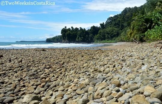
The Beach
Although getting to the beach is a bit of work, you will be well rewarded for your efforts. Playa Arco is a gorgeous tan sand beach with a steep embankment of thick green jungle as its backdrop. When we visited, we were immediately greeted by a family of howler monkeys that were enjoying the lush vegetation. Small islands just offshore make for a dramatic ocean view.
Although it may seem like you have arrived at the main part of the beach when you get off the forest trail, keep walking north along the sand. Just past the steep rocky cliff is an even more expansive section of the beach, an awesome cave, and two small waterfalls.

View of Playa Arco
The Cave
Before you round the corner to the second section of Playa Arco, you’ll notice a narrow opening in the rocky cliff. This cave goes all the way through to the other side (about 50 feet). At high tide, ocean water rushes inside so it isn’t safe to enter, but at low tide you can wade your way through.

Cave entrance on the south side (note the tide is still flowing into the cave)
The small channel of water in the cave varies in depth. When we visited, it was about waist level at the deepest part and only ankle- or knee-deep otherwise. There were some slimy logs and rocks along the bottom so take your time and tread carefully. One thing we really enjoyed about the cave was that the northern entrance had nice shallow water for our son, Sam, to splash around in. We also saw some cool crabs clinging to the walls inside.

Inside the cave
The water outside the southern entrance of the cave also gets this really beautiful clear green hue when there hasn’t been too much rain. Check out this picture on our Pinterest board that our friends took.
The Waterfalls
Near the northern entrance of the cave are a couple of small waterfalls cascading down the steep embankment. These were perfect for rinsing off after swimming in the ocean or wading through the cave. They were also really refreshing! Both were flowing well when we visited in October during the rainy season, but we can imagine at least one of them drying up to a trickle at other times of year.
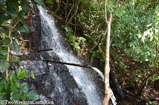
One of the small waterfalls. Perfect for a rinse off!
Planning Your Visit
The Ballena Sector Ranger Station is open every day from 7 a.m. – 4 p.m.
Parking is somewhat secure because the lot is in front of the ranger station but never leave any belongings in the car.
The ranger station has a bathroom, but it is a bit hidden. Follow the path outside the ranger station to the left past the cabins. The last building is the bathroom. A rustic shower is also near the main entrance, just past the ranger station.
Admission: $6 foreigners and ₡1,000 nationals.
Admission tickets are valid at all Marino Ballena National Park entrances on the date of purchase. Be sure to go beach hopping if you have time. We highly recommend Playa Uvita and the whale tail.
Playa Arco is somewhat sheltered and decent for swimming, but this whole stretch of coastline experiences riptides so do use caution.
The portion of the walk along the beach is in direct sunlight and extremely hot. Wear a hat and sunscreen and bring water.
A trip to Playa Arco will leave you feeling like you have discovered a secret beach. Our visit reminded us of when we were exploring Costa Rica for the first time and everything was new and amazing. It not only offers a beautiful beach, but the jungle surrounds, cave, and waterfalls make for a unique experience. Playa Arco is also one of the most secluded beaches we’ve ever visited (there was only one other family there) so you might have it all to yourself.
Have you visited Playa Arco? What was your experience like? Leave us a comment below (Email subscribers, click here to post your comment online.)
Looking for more info to plan your trip to Costa Rica’s Southern Zone? Check out these articles:
The Costa Ballena: Uvita, Dominical, and Ojochal – General information about this area, which is one of Costa Rica’s most up and coming destinations. Includes activity and lodging ideas.
Visiting the Beautiful Nauyaca Waterfalls – If you are visiting the area, you can’t miss one of Costa Rica’s most spectacular waterfalls, just 45 minutes north of Playa Arco.
10 Daypack Essentials for Costa Rica – If you’re doing shorter hikes in Costa Rica like this one, consider keeping some of these items your pack.
The post Playa Arco: A Secret Beach Near Uvita appeared first on Two Weeks in Costa Rica.
October 7, 2016
Playa Hermosa (Guanacaste): Costa Rica’s Northern Beauty
Two Weeks in Costa Rica |
One of the best places in Costa Rica’s popular Guanacaste Province to relax and unwind is Playa Hermosa. This small community along the northern Pacific coast draws repeat visitors year after year with its gorgeous beach and peaceful charm. Although its location makes Playa Hermosa feel somewhat isolated, the small but well developed town offers many amenities. You’ll find fine dining steps from the sand and varied accommodations, including condos, timeshares, vacation rentals, and hotels. In this post, we’ll share what you need to plan your visit to this beautiful beach town.

Location
Playa Hermosa, which translates to Beautiful Beach, is located in northern Guanacaste Province. Keep in mind that Costa Rica has several beaches named Playa Hermosa, including near Jaco, Santa Teresa, and Uvita, but the one we are covering here is in Guanacaste. Liberia International is the closest airport, at about 45 minutes away.
Playa Hermosa Guanacaste (sometimes called Playa Hermosa GTE) sits between two points that divide it from the lively town of Playas del Coco to the south and Playa Panama to the north. It is situated in a valley with much of the real estate development in the surrounding hills. The town has two main ways where many businesses are located. The first and second entrances, as people refer to them, run perpendicular to the beach. There are also some businesses spread out along the main road to town and on the road closest to the ocean. On our last visit, we stayed on the second entrance and enjoyed being only a few blocks from the beach. Hermosa is fairly concentrated, however, so no matter where you are, you’ll be a walk or short drive to everything.

Playa Hermosa sits in a green valley during the dry season
About Playa Hermosa
This small resort town is popular for those looking to relax in a tranquil setting. Playa Hermosa is seldom crowded and it is almost always possible to find your own spot on the sand. The destination tends to draw families who come for the calm ocean waters, as well as groups taking advantage of the vacation rentals and condos. Although Playa Hermosa has a good selection of restaurants, it does not have much nightlife. You can find a party scene in Playas del Coco, though, which is only a short cab ride away.
Activities
Beaches and Water Sports
The main attraction in Playa Hermosa is its beautiful light gray sand beach. This wide cove stretches about 1.2 miles (2 km) and has lots of palm and figs trees for shade. Swimming and water sports like jet skiing, kayaking, stand-up paddleboarding, and banana boat rides are popular things to do. The Gulf of Papagayo just beyond the bay is full of marine life. Sport fishing, snorkeling, and diving are especially good. Playa Hermosa has some local dive sites, and more advanced divers will enjoy exploring the Catalina and Bat Islands, where you can often find manta rays, white-tip reef sharks, and bull sharks.

Just around the point from Playa Hermosa is a little-known beach that we absolutely love called Playa Penca. This is a small cove with light gray sand and clear turquoise water. It is a good spot to just soak up the sun, but also has a reef with some awesome snorkeling. We have seen a lot of fish not far from shore, including some pufferfish, needle-nose fish, and stingrays. Hopefully this beach will remain easy for the public to access. Last time we were there, the adjacent property had been chopped. We heard it was for a future Ritz Carlton!
Directions to Playa Penca: Playa Penca is not marked and a little hard to get to. Here’s a map with the exact location. When you turn off the main road, tell the security guard in the booth that you’re headed to Playa Penca. He will take your license plate number. Follow the road to the parking area. It is very steep in spots with loose gravel so you will definitely want 4×4. Be sure not to leave anything in the car as this is a remote area and break-ins sometimes occur. This is also a great spot to see Playa Hermosa and Playas del Coco from above so be sure to bring your camera!

The beautiful Playa Penca
Other Things to Do
From Playa Hermosa, you can organize all the usual tours out of Guanacaste. Zip lining, ATV, horseback riding, and catamaran tours are possible. Farther inland, you can find more day trips that lead to waterfalls, hot springs and mud baths, and wildlife rehabilitation centers. National parks within a couple of hours’ drive are Las Baulas National Marine Park (seasonal turtle watching), Rincon de la Vieja (volcanic features), Palo Verde (river boat tours), Santa Rosa (hiking and site of historic battle), and Lomas Barbudal (off-the-beaten-path reserve with a river and waterfall).
In the near future, we’ll be coming out with a complete guide to activities in northern Guanacaste. Click here to subscribe and receive it by email.
Restaurant Recommendations
Playa Hermosa has a small, but satisfying, dining scene. One thing to note is that we find prices to be on the high end for Costa Rica. On our last visit, we ended up spending around $70 for the two of us on dinner every night. Here are some of our favorite restaurants.
Sandbar
We loved everything about our recent visit to Sandbar. Sandbar is a newer restaurant in Playa Hermosa that is making its presence known. They offer a creative international menu, which rotates regularly. On the signature menu, you can find classics like shrimp tacos, burgers, and salads, and a featured menu has more innovative choices like braised bacon in a cassava dumpling or a green curry lentil burger. Sandbar uses all organic produce and locally sourced meat and fish. They have a fun cocktail menu, local craft beer, and brunch on Sundays. Main road coming into town in the plaza at the entrance of Hermosa Heights.

Eggs Benedict at Sandbar’s Sunday brunch
Ginger
A longstanding favorite in Playa Hermosa, Ginger offers refined tapas that are full of flavor. Many dishes are Asian or Indian inspired, but they also incorporate traditional ingredients like local fish. Some of our favorite small plates were the ginger rolls with poached salmon, spicy chicken samosas, and Thai red curry beef on plantains. Ginger is a romantic spot with a modern, candle-lit outdoor dining area. Just after the second entrance on the inland side.

Poached salmon rolls at Ginger
Roberto’s
Roberto’s is located inside La Gaviota Tropical Hotel on the beach. From the outdoor patio or tables set up on the sand, you can take in the beautiful view or watch the sun sink into the Pacific. Roberto’s has a basic bocas (snack) menu as well as rice dishes, burgers, and sandwiches. Their dinner menu features entrees like shrimp with avocado, Caribbean chicken, and tuna steak. Second entrance, on the beach.

Ceviche and patacones with a view at Roberto’s
Aqua Sport
Aqua Sport is another good option for a drink or casual meal on the beach. They have a big outdoor patio and some tables and chairs right on the sand. Typical bar fare like burgers and fish tacos fills the menu, but they also have traditional Costa Rican and even Peruvian specialties. Excellent spot for sunset and sometimes has live music. Second entrance, on the beach.

Beach-side dining at Aqua Sport
Hotel Recommendations
Hotel Mangaby
We had a wonderful stay at this small, family-run hotel right in the middle of town. Hotel Mangaby has simple, but spacious and extremely clean, rooms with A/C and hot water. Rooms overlook the gorgeous pool, which is quite large and surrounded by lush gardens. The small restaurant serves a made-to-order traditional breakfast. Hotel Mangaby is popular with visitors and you’re likely to see locals there as well. Double room, $70-100. Check Rates and Availability Here.

Hotel Condovac
If you’re looking for more of a resort setting, consider Club and Hotel Condovac. This is a larger complex on the northern end of the beach that offers condo-style accommodations with kitchenettes. The facility is a bit dated, but very affordable. Condovac is situated on a steep hill so has nice ocean views. The two-bedroom villas are good for families and groups. Villas, $100-550. Check Rates and Availability Here.
Hotel Bosque del Mar
This beautiful boutique hotel is in a prime location on the beach. Suites are big, clean, and comfortable with separate living areas. The property has many mature trees, which draw wildlife like monkeys, iguanas, and hummingbirds. Bosque del Mar is good for couples, but also families and groups because some suites can be connected. Located on a quiet section of the beach, but a little far from restaurants and services so it’s nice to have a car. Junior Suite, $150-200. Check Rates and Availability Here.

Photo Credit: Hotel Bosque del Mar
Playa Hermosa is the perfect destination to spend a week relaxing on the beach or to close out a busy vacation. Although small, it has enough to keep you busy and plenty of restaurants to excite your pallet. We can’t wait to get back to Playa Hermosa ourselves, and can see why so many people return year after year.
Are you visiting Playa Hermosa? Leave us a comment below. (Email subscribers, click here to post your comment online.)
Some of the links in this post are affiliate links. If you book a hotel using one of the links, we receive a small commission at no extra cost to you. Read our Privacy Policy for more information.
Looking for more information to plan your trip to Costa Rica? Check out these posts:
La Fortuna: What to Expect from Costa Rica’s Most Popular Destination – La Fortuna is home to the mighty Arenal Volcano and is commonly paired with destinations in Guanacaste like Playa Hermosa. This post has everything you need to plan your visit.
Driving in Costa Rica: What to Know Before You Go – Playa Hermosa is a drive from most activities so having a car is recommended. See our tips before you hit the road and look for our rental car discount too!
Monteverde: A Forest in the Clouds – Another popular place to pair with Guanacaste destinations is the misty mountain town of Monteverde. Bring your jacket for this one as temps are much cooler than at the beach.
The post Playa Hermosa (Guanacaste): Costa Rica’s Northern Beauty appeared first on Two Weeks in Costa Rica.
September 29, 2016
10 Daypack Essentials for Costa Rica
Two Weeks in Costa Rica |
Whether you are hiking one of Costa Rica’s rugged jungle trails or planning a relaxing walk in a national park, having what you need readily available can make a good day that much better. Through our years of traveling and living in Costa Rica, we have done countless day hikes around the country. In doing so, we have learned to keep some essential items in our backpack at all times. This has saved us on many occasions or at least made life easier. In this post, we’ll share a simple list of things we keep in our daypack for hiking that you might want to include too. Some of these items also might be helpful if you are just carrying your bag around town or going to the beach.
Note: We have a separate post with more general packing tips. Check out Packing for Costa Rica: The Essentials for info on the best footwear and clothing, how to prepare for the rainy season, and more.

Choosing a Daypack
Before we get into the packing details, we’ll address the daypack itself. We were looking for a new hiking daypack a couple of months ago and couldn’t believe the amount of time it took us to decide on one. The biggest question we had was what size to get. Too big and you look like you are going on a month-long trek and too small leaves you wondering where to actually fit stuff (one of our old packs is really small).
After reading a lot of reviews and comparing different sized daypacks at or under $50, we finally settled on the Osprey Daylite Backpack. So far, we are really happy with it and have taken it on about a half-dozen hikes. It’s a simple, small-to-medium-sized backpack (13 liter), ultra-lightweight, comfortable, and seems like it will hold up for a long time. One of the big selling points for us was the vented back panel since it gets so hot in Costa Rica. This is a major improvement from our old one from Eastern Mountain Sports that didn’t breathe and always left us soaked with sweat. The Osprey also has the ability to store a hydration bladder (up to 3 liters), which we don’t use ourselves but know is important to some people. Instead, we just use the two mesh side pockets for our water bottles. For a smaller pack, it holds a lot and isn’t bulky when full.

To give you an idea of size, this is how the Osprey Daylite fits Jenn.
10 Daypack Essentials for Costa Rica
Here’s our list of what to keep in your daypack for hiking in Costa Rica.
1. Mini First Aid Kit
We all hope no one gets hurt on vacation but it does happen. We’ve used our mini first aid kit many times, from bandaging a small cut when snorkeling to helping patch up a motorcyclist after he went off the road and over the handlebars! Over time, we’ve added a few things to our kit too like allergy medicine, Advil for after-hiking relief, and some Nexcare Band-Aids, which are great for blisters because they are waterproof.
2. Sunscreen
The sun is extremely strong in Costa Rica so you’ll want some protection on sunny trails. Sunscreen is at least twice as expensive in Costa Rica so it’s best to bring it from home. Our favorite type is Neutrogena Ultra Sheer because it is waterproof and not greasy.
3. Insect Repellent
You’re likely to encounter more mosquitoes when hiking than you would in the middle of town. Sometimes, if you are near water or even just in the humid jungle, they can be pretty bad. We always carry at least two types of repellents. For normal use, we use a lemon eucalyptus blend. Repel has a good one that we use a lot or lately Jenn has been mixing her own with coconut oil and pure lemon eucalyptus oil, which smells really nice. Another natural kind we keep in our bag is doTERRA’s Outdoor Blend. This is more potent (and expensive), but it works the best so we like it for areas with lots of bugs. Of course, Deet and Picaridin-based repellents work well too. Read our post on Mosquitoes in Costa Rica for more info and tips to prevent bites.
4. Small Change/Cash
If you are going on a hike or day trip, you might choose to leave most of your money in the hotel safe or hidden away in a money belt. That’s great until you are dying of thirst and see someone selling cold coconut water. You may need cash to tip a parking attendant who watched your car too. Keeping a few dollars or local colones at hand is always a good idea.
5. Camera Supplies
Some important items that we always try to remember on a hike are camera accessories. We keep a few microfiber cloths and lens cleaner to wipe off dirty or water-spotted lenses. And if we are going on a longer hike, we’ll take an extra camera battery and memory chip. We also have a small gorilla tripod that grips onto tree branches or stands up on uneven surfaces that we sometimes take along.
6. Flashlight or Headlamp
Chances are that you aren’t planning to hike in the dark but you never know. If you are like us, you can’t help but explore around the next corner and sometimes lose track of time. After almost not making it back before dark in Drake Bay once, we now keep a headlamp and mini-Maglight in our bag at all times. Both are very small and don’t add much weight.
7. Light Rain Jacket or Poncho
Costa Rica is in the tropics, and while there are drier months, you never know when a pop up shower or rainstorm might hit. A foldable poncho or light rain jacket that you can take out and quickly put away can be really handy.
8. Waterproofing
On the topic of rain, you always should be prepared to protect what’s in your daypack too. An inexpensive rain cover that stretches over your bag can keep most water out. But if you are traveling by boat (like to Tortuguero or Drake Bay) or doing something adventurous like waterfall rappelling, ATV tours, etc., you might want more protection. In those instances, we recommend a waterproof cell phone case or even a small dry bag that can hold multiple items like your camera. We have this 10L one that rolls up small. Additionally, it’s a good idea to carry a few plastic shopping or zipper bags to wrap things up in. These are handy for wet clothes too!
9. Field Guides
Field guides are nice to take on a hike so that you can identify the wildlife you’re seeing, but we seldom pack them because they are so heavy. Luckily, there are some laminated fold-out ones for Costa Rica like these that are lightweight and have a good variety of what you might see. They’re especially fun if you’re traveling with kids so they can figure out what they’re seeing. We’ve purchased a half-dozen of them, from butterflies and birds, to mammals, and even fruits.
10. Photocopy of Your Passport
Most people recommend carrying a copy of your passport at all times. Although you are unlikely to need it on a hike, we have been asked for ours at a couple of national parks. Before you leave home, make a quick copy of your photo page and you’ll be all set.
That’s our list of ten essential items for your daypack in Costa Rica. Of course, you’ll have to add the obvious things like water and snacks, but hopefully we’ve pointed out some items that you didn’t think of.
What’s in your daypack? Have something essential that we missed? Leave us a comment below. (Email subscribers, click here to post your comment online.)
Some of the links in this post are connected to affiliate programs we have joined. If you make a purchase using one of the links, we get a small commission. This doesn’t cost you anything extra and helps us keep providing information on this website for free. Thanks for your support!
Looking for more practical information to plan your Costa Rica vacation? You might like these posts:
Packing for Costa Rica: The Essentials – We’ve covered what to pack for hiking here, but what about things for the rest of your trip? This post has a detailed list of everything you’ll want to take.
Simple Spanish for Visiting Costa Rica – Print out this list of common words and phrases and take it out when you need to order food, ask for directions, or greet someone.
Driving in Costa Rica: What to Know Before You Go – Driving in a foreign country can be intimidating, but this post will take out a lot of the mystery. Tips on safety, laws, and more.
The post 10 Daypack Essentials for Costa Rica appeared first on Two Weeks in Costa Rica.
September 15, 2016
Lomas Barbudal Biological Reserve: An Oasis of Green in Guanacaste
Two Weeks in Costa Rica |
As people who love hiking, we are always on the lookout for the next great trek. When considering the possibilities in Guanacaste, the Lomas Barbudal Biological Reserve piqued our interest. Not much information was available about this reserve, but we had heard that it featured a river and watering hole year-round. Anyone who has visited the Guanacaste region of Costa Rica during the dry season knows that water can be extremely sparse this time of year. After visiting for ourselves, we can say that Lomas Barbudal did, in fact, have lovely, flowing water and lush greenery even at the end of the dry season. In this post, we’ll share why our recent hike was one of our all-time favorites and let you know what to expect on the trails.

Orientation
Lomas Barbudal Biological Reserve (Reserva Biologica Lomas Barbudal) is a relatively small, 2,646 hectare (6,538 acre) area of protected land in Guanacaste Province. Although most people have never heard of it, it shares a border with one of Costa Rica’s more well-known national parks, Palo Verde. The main entrance to Lomas Barbudal is located a short distance off the Interamericana (Highway 1), in between Bagaces and the city of Liberia.
Although the park is easy to get to, the road for the turnoff is not marked and easily missed. See the end of this post for detailed driving directions.
About the Reserve
Travel guides often describe Lomas Barbudal as being an area for scientific study. The reserve is indeed home to an impressive number of insects, including about 250 types of bees alone, as well as many birds and animals. Though no doubt research-worthy, we found the reserve to be a great stop for anyone looking for off-the-beaten-path hiking in Guanacaste. Not only were the trails easy to access, but the park offered so much to see for visitors.
Tip: Many of Costa Rica’s parks get very busy, but this is a great option if you’re looking for something lesser known. On our visit, we were the only people there. We asked the park ranger how many visitors they had per day, and he said three or four!
In addition to insects, the park is also known for its trees. Endangered Ron-Rons, Mahoganies, and Rosewoods all grow within the park. These species are hard to find elsewhere in Costa Rica due to logging and their use in furniture-making. Other interesting trees you might see include the Pochote (which has dangerous-looking spines), Guanacaste (Costa Rica’s national tree), and Naked Indian. If you happen to visit in March when the brilliant Corteza Amarillas are blooming, you’ll also get to see a showering of yellow flowers.

Naked Indian Tree, also known as the Tourist Tree because of its red, peeling bark
Trails at Lomas Barbudal
Lomas Barbudal Biological Reserve has three public trails. Each is accessed from Casa Patramonio, the visitor’s center/ranger station that marks the entrance to the park. If you have a few minutes before you start hiking, take a quick walk through this rustic visitor’s center. There are a number of displays with artifacts that have been found in the reserve like pre-Columbian pottery and casts of different animal prints. There are also photos with information about the park. Much of it is in Spanish, but you can get still get a lot out of it even if you don’t speak Spanish.
Trail Map: The park ranger did not provide trail maps when we checked in, but they do have one on display. Click here for a picture we took of it.
Sendero Gigantes del Bosque
Sendero Gigantes del Bosque (Giants of the Forest Trail) is the shortest trail at Lomas Barbudal. The dirt path is flat and well maintained. After a quick 15 minute walk from Casa Patramonio, you will arrive at a nice pool surrounded by green forest (see cover photo, above). When we visited at the end of the dry season in April, it was still full of water and looked quite refreshing. We didn’t opt to swim, but you probably could. Just watch out for the little cichlid fish (yes, just like the ones you find at the pet store). Note: We did encounter some aggressive mosquitoes along this stretch so be sure to bring repellent.

Trail conditions along Sendero Gigantes del Bosque
Sendero Catarata
Sendero Catarata (Waterfall Trail) also starts at Casa Patramonio, but intersects with Sendero Gigantes del Bosque later on, making for a nice loop. This is one of the longer trails, but is still fairly short at about 2.4 km (1.5 miles). We spent the most time on this trail and highly recommend it for wildlife viewing and the waterfall.
The trail follows the Rio Cabuyo (Cabuyo River). As we mentioned, Guanacaste gets extremely dry for part of the year and it is common for rivers to dry up completely. That is why we were so surprised to see a lovely flowing river. Interestingly, the river was keeping the foliage nice and green on the right side of the trail, closest to the water, but the left side was dry and barren.

Extremely dry forest on the left side of the trail

Lush, green forest on the side closest to the river
Lomas Barbudal, like much of this region, consists of tropical dry forest, meaning that the trees lose their leaves during times of drought. The first picture above really shows this.
This river and the reserve’s many other streams, pools, and springs are so important to not only the trees and plants, but also to wildlife. Animals come here year-round to drink water, especially during the dry season when resources are limited. A sign inside the visitor’s museum says it best:

Given this, it should be no surprise that wildlife was abundant on our visit. For animals, we saw howler monkeys, white-faced monkeys, paca, and agouti. We also saw several kinds of lizards, including the brown basilisk and Jesus Christ.

An agouti alongside the trail

White-faced monkeys are harder to find in Guanacaste, but we saw quite a few in Lomas Barbudal
If you’re into birding, you’ll also be happy at what you can spot. Over 130 kinds of birds have been seen in Lomas Barbudal, including hard-to-find species like the Scarlet Macaw. On our visit, we saw two types of trogons (Elegant and Black-headed); a Turquoise-browed Mot-Mot; Long-tailed Manakin; Squirrel Cuckoo; Royal Flycatcher; Dusky-capped Flycatcher; Slate-headed Flycatcher; White-collared Seedeater; and Striped-headed Sparrow.
After following the trail for about a mile, you will reach the waterfall. This small cascade is only about 12 feet tall (3.7 meters), but very pretty. It is visible from the trail, but you’ll have to climb down to the riverbank for the best view. You can also swim here, and right at the base of the falls is a bench where you can sit and let the cool water shower you from above.
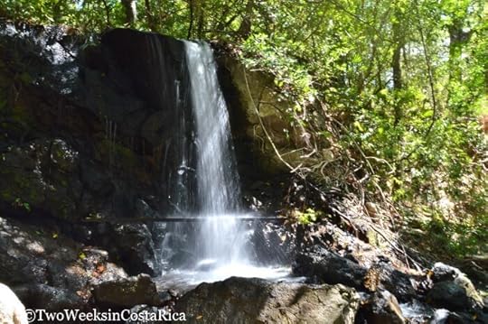
Waterfall in Lomas Barbudal, flowing even at the end of dry season
Trail Conditions: Sendero Catarata was mostly flat, but did have some narrow, rocky areas that were more difficult to navigate. There were also a few parts that would cross water, depending on the season. Makeshift bridges made with old boards had been put down, but many of them were in disrepair. Although this wasn’t a difficult hike, sections of the trail were completely exposed to the sun. With temperatures in the 90s (32°C), walking even on flat ground can be a workout.

Be careful crossing the bridges!
Sendero Carablanca
Sendero Carablanca is another trail off Sendero Catarata that is supposed to have a couple of scenic viewpoints. We didn’t do this one as it cut through the extremely dry part of the park where all the trees had lost their leaves and it was quite hot.
Park Hours
Open daily, 7 a.m. to 4 p.m.
Cost
$10. Note: The park ranger did not charge us on our visit.
Tips for Visiting
Plan to spend about 3 hours to do Sendero Gigantes del Bosque and Sendero Catarata, and an additional hour or so if you plan to do the third trail. It doesn’t take that long to walk the park, but you’ll want to go slowly to see the most. We found the birds and animals here to be more skittish since they are not used to seeing people.
Bring plenty of water (at least 1 liter per person) as temperatures are often well into the 90s (32°C) and some snacks. The nearest small store is at the highway, several miles away.
Wear lightweight clothing that dries quickly and bring sunscreen, a hat, and insect repellent. Here is a link to our post on preventing mosquito bites, which includes some recommendations for repellents that work well in Costa Rica.
Hiking boots or sturdy sneakers are recommended so that you have solid footing on the makeshift bridges and rocky areas.
Rainy Season: The ranger said that the trails don’t get too muddy during the rainy season so visiting that time of year should be fine. He did warn about more mosquitoes, however, so be sure to use repellent. We would also recommend waterproof hiking sandals like Keens or hiking boots or sneakers you don’t mind getting wet/dirty in case you have to cross the small streams.
Directions to Lomas Barbudal
From Liberia, drive south along Highway 1 for about 14 km (8.7 miles). When you approach the small town of Pijije, look for the turnoff on the right immediately after the pedestrian walkway that crosses the highway. It is near a small store called Abastecedor Pijije. Take the dirt road and follow it for about 7 km (4.3 miles). The road is flat most of the way and passes open fields and a few houses. Towards the end, it becomes steep. 4×4 with higher clearance would probably be necessary during the rainy season.
We weren’t sure what to expect when visiting the Lomas Barbudal Biological Reserve but had such a wonderful time. We have hiked throughout Costa Rica and are usually partial to the rainforest, but the tropical dry forest of this reserve was so rich with life. Not only did it have water at the end of the dry season, but it was also full of wildlife. If you’re looking for an off-the-beaten-path day hike around Guanacaste, we highly recommend Lomas Barbudal.
Have a question about the reserve? Leave us a comment below. (Email subscribers, click here to post a comment online.)
Looking for more information to help you plan your visit to Guanacaste? Check out these posts:
Playa Brasilito: An Authentic Costa Rican Beach Town – Guide to visiting the local fishing village of Brasilito. This town might be worth checking out if you’re looking for a more authentic experience but still want to be close to the amenities.
Diria National Park – Diria is another lesser-known place for hiking in Guanacaste with a different feel from Lomas Barbudal. Check out our tips for visiting.
Costa Rica Rental Car Discount – If you’re staying at one of the beach towns in Guanacaste, renting a car is the best way to do local hikes and see many of the attractions. Click here to learn more about our rental car discount.
The post Lomas Barbudal Biological Reserve: An Oasis of Green in Guanacaste appeared first on Two Weeks in Costa Rica.
September 7, 2016
Road Conditions of Specific Routes in Costa Rica
Two Weeks in Costa Rica |
If you’ve read our article on Driving in Costa Rica, then you’ve already learned the basics of what to expect when out on the road. General traffic laws, safety tips, and Costa Rica-specific idiosyncrasies are all covered in that post and should be your first source of information on driving in the country. But if you’re wondering what road conditions are like for specific routes, this is the post. We have driven most of Costa Rica ourselves, and in this article, we’ll name the most commonly traveled roads and tell you about their conditions.
Keeping our information current: If you have recently driven one of these roads and have an important update to share, let us know in the comments below. Be sure to include your travel dates. We’ll update our information as necessary based on those reports as well as our own most recent drives.
How to Use This Guide
It is important to note that many of the roads in Costa Rica may be numbered on a map, but they are not marked with any actual road signs. If you are planning your routes ahead of time, we recommend using our guide, along with Google Maps and/or this waterproof Costa Rica travel map. Once you are here, you can use GPS to make sure you are on the right road. Or, if you have an Internet connection, you can use Google Maps or the popular Waze App to cross-reference in the same way. If you are in a rural area, the waterproof map mentioned above can be really helpful if you don’t have an Internet signal.
Tip: If you haven’t rented a car yet, check out our Rental Car Discount page, which can save you 10-25% with Adobe, one of the top companies in Costa Rica. You’ll also get a discount on a GPS, free second driver, and other extras. Adobe also rents Wifi hotspots, so you can use your device in the car to help navigate or surf the web.
Common Driving Routes in Costa Rica
IMPORTANT: Road conditions can change quickly in Costa Rica due to weather, natural disasters, construction, and other factors. The descriptions below are accurate and updated to the best of our knowledge, but because conditions are constantly changing, we don’t guarantee our accuracy. Always check for the latest road closures on Costa Rica’s government website before you set out. And if your experience driving a certain route was different than what we said, help us get the information right by leaving a comment below.
Use the Links Below to Jump to a Specific Route
Route 1
Route 2
Route 3
Route 4
Route 10
Route 14
Route 17
Route 18
Route 21
Route 27
Route 34
Route 39
Route 142
Route 150
Route 155
Route 239
Route 245
Route 256
Route 702
Route 911
Route 1 – Inter-Americana Highway
Connects many destinations, including San Jose and Guanacaste; Guanacaste and the Central Pacific Coast; and some Central Valley towns west of San Jose.
Major route. Completely paved, marked with lines, has good signage for towns/cities.
Starts in San Jose and goes all the way to the northern border with Nicaragua.
In parts, this is a modern four-to-six lane highway (e.g., near San Jose and SJO International Airport and between Liberia and Canas). Other parts are two lanes or two lanes with an occasional third passing lane (e.g., between La Garita and Esparza; Barranca and Canas; Liberia and Nicaragua).
Section between La Garita and Esparza was the old highway from San Jose to the northern Pacific coast/Guanacaste. It is still functional but curvy and takes longer than the newer highways (Route 27 to Route 23, then back onto Route 1).
Traffic can be congested around San Jose. Slowdowns also occur between Barranca and Canas because of large trucks traveling slowly and no room to pass.

Route 1 near San Jose
Route 2
Connects San Jose to Southern Zone and is a slower way to get to the Southern Pacific Coast. Destinations on this route include San Gerardo de Dota and San Isidro de El General.
Major route. Completely paved, marked with lines in most places, has good signage for towns/cities.
Starts in San Jose and goes all the way to the southern border with Panama.
In parts, this is a modern four-lane highway (e.g., between San Jose and Cartago, and near San Isidro de El General). Other parts are two lanes or two lanes with an occasional third passing lane (e.g., between Cartago and San Isidro de El General, and from San Isidro de El General to the Panama border).
Section between Cartago and San Isidro de El General is very mountainous. This stretch is known locally as Cerro de la Muerte (Hill of Death). The road is in good condition but is narrow and very high altitude. It should not be driven at night because of thick fog and cloud cover.
Route 2 was the old highway from San Jose to the Panama border at Paso Canoas and Costa Rica’s southern Pacific coast. Today, most people visiting the southern Pacific coast take the coastal route (Route 27 to Route 34), which is flatter and faster. Route 2 is a very scenic drive, however, if you have some time and are up for a little adventure. At its highest points, the landscape turns to shrubby plants and trees, typical of the high-altitude forest. It also passes huge wind turbines.
Pavement south of Palmar Sur to Panama border is bumpy and has potholes to navigate.
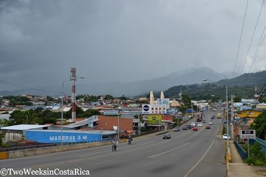
Route 2 near San Isidro de El General
Route 3
Connects western San Jose to Route 27 in Orotina. Passes through the cities of Heredia and Alajuela and is used to access the town of Atenas. Often used as alternative route to Central Pacific Coast if Route 27 is closed. Many rental car agencies have offices on this road, near SJO International Airport.
Paved two-lane road marked with lines with fairly good signage for towns/cities.
Has more traffic lights and congestion near San Jose, Heredia, and Alajuela.
West of Alajuela, this road becomes more rural and scenic. It is extremely curvy with many hills, making it a slow, but beautiful, drive.
Route 27 is the preferred route from SJO International Airport to the Pacific coast because it is much faster. Route 3 is functional, though, if 27 is closed for a holiday (see Route 27, below, for more info on road closures).
Route 4
Connects very northern Guanacaste to La Fortuna/Arenal and Caribbean side of the country. Destinations accessed using this route include La Fortuna, Tenorio Volcano National Park/Rio Celeste, Puerto Viejo de Sarapiqui, and Tortuguero.
Secondary highway with two lanes. Completely paved, marked with lines in most places, has fairly good signage for towns/cities.
Easy drive, mostly flat road that passes lots of agricultural fields like pineapples, papayas, and sugar cane.
This is the most common route between La Fortuna and Tortuguero or Puerto Viejo de Talamanca on the Caribbean coast.
Route 10
Connects Cartago in Central Valley to Siquirres on Caribbean slope. The most popular tourist destination on this route is Turrialba.
Paved two-lane road, marked with lines. Hilly at times but smooth driving.
Passes farm fields like coffee and sugar cane, as well as dairy pastures and sections of forest.
Traffic can be slow in Turrialba and Paraiso.
The old railroad from Cartago to the Caribbean port of Limon once passed through sections of this road and the old tracks are still visible in some places.
This was the old highway to the Caribbean coast. Today, most people visiting Caribbean towns like Cahuita and Puerto Viejo de Talamanca take Route 32 out of San Jose because it is faster.
Route 14
Connects the small city of Rio Claro to Golfito in Southern Zone.
Paved two-lane road in fair condition.
Route 17
Local road through port city of Puntarenas. You will take this if you are crossing the Gulf of Nicoya on the Puntarenas-Paquera Ferry.
Paved two-lane road, marked with lines. Smooth driving.
Residential and commercial zone with some traffic lights.
Route 18
Connects Route 21 (near Nicoya) to the Inter-Americana Highway/Route 1. Used as a cut through between Guanacaste or Nicoya Peninsula and points east like Monteverde, San Jose, and Puntarenas.
Paved two-lane road, marked with lines. Smooth driving.
Bridge at the mouth of the Tempisque River has a beautiful view of the Gulf of Nicoya.
Route 21
Connects the city of Liberia to southern Nicoya Peninsula. LIR International Airport is located on Route 21. Driving part of this route is also necessary to reach most beach towns in Guanacaste like Tamarindo, Flamingo, Playa Conchal, Playa Hermosa, Samara, and Nosara.
Major route. Secondary highway with two lanes. Completely paved, marked with lines, has fairly good signage for towns/cities.
Very flat, smooth driving.
Around town centers, locals often walk or ride bicycles along the side of this road so use caution for their safety.
There is often traffic near Liberia and the airport but otherwise the road is not very busy.
Route 23
Connects Route 27 to Route 1 near Puntarenas. This route is used in combination with Route 27 to get to destinations in northwestern Costa Rica like the Nicoya Peninsula, Guanacaste beaches, and Monteverde from San Jose (instead of taking Route 1 all the way from San Jose). Also connects to Route 17 if traveling into Puntarenas.
Secondary highway with two lanes and a third passing lane near Caldera. Completely paved, marked with lines. Some stoplights closer to Puntarenas in the commercial zone.
This road goes right next to the beach for a short stretch in Caldera. The views of the Gulf are very pretty and lots of locals visit the beach. Cruise and/or container ships often can be seen docked in Caldera or just offshore.
Route 27 (Autopista)
Connects San Jose to all destinations on Pacific Coast. Also most common route to Monteverde.
Major route. Completely paved, marked with lines, has good signage for towns/cities.
Around San Jose, this is a modern four-to-six lane highway. Going west out of the city, it turns to two lanes or two lanes with an occasional third passing lane. This highway is often congested since it is a popular route and there can be truck traffic.
Toll road. Tolls range from 310 to 670 colones and are more frequent closer to San Jose. Have colones available or small US dollars ($1 bills).
The Coyol Radial connects Route 27 with Route 1 for those going to or from the SJO Airport. The sign for the airport is very small so keep a lookout. The exit name is Coyol/Ciruelas.
There is often construction traffic west of the town of Concepcion, where workers are stabilizing the steep slopes next to the highway. It has been going on for years.
On the Sunday after big holidays (Christmas, New Years, Easter, etc.), westbound traffic is often rerouted from Route 27 to Route 3 or Route 1. This occurs near Orotina, where all lanes of Route 27 are turned into eastbound lanes in the direction of San Jose in order to ease the congestion of people traveling home after the holidays.

Route 27 west of Escazu
Route 32
Connects San Jose to Caribbean slope, ending at the port city of Limon. This is the newer way to access the Caribbean Coast, which was formerly through Cartago and Turrialba on Route 10.
Major route. Completely paved, marked with lines, has good signage for towns/cities.
Two lanes or two lanes with an occasional third passing lane.
Steep at times. Also a popular trucking route, so expect slowdowns at the steepest points.
Only road in Costa Rica with a tunnel. This tunnel goes under a section of Braulio Carrillo National Park. It creates an important land bridge for animals, which can safely cross over the top.
Sides of the road along the steep descent to Caribbean are covered with lush foliage. Sometimes landslides occur, especially during the rainy season, so use caution after heavy storms.
This road can get fogged in and visibility is poor in the rain. Avoid driving at night.

Zurqui Tunnel going under Braulio Carrillo National Park
Route 34 (Costanera Highway)
Connects Route 27 with Central and Southern Pacific Coast (Jaco, Quepos/Manuel Antonio, and Dominical and Uvita).
Major route that follows the coast. Completely paved, marked with lines, has good signage for towns/cities.
Two lanes or two lanes with an occasional third passing lane. Some steep areas between Tarcoles and Jaco but otherwise relatively flat and smooth.
Starting in Parrita and going south to Dominical, much of the highway is surrounded by palm-oil plantations.
A police checkpoint is often set up near Dominical. The officers might request to see your passport.
Common stop is the Tarcoles River Bridge, where you can see very large crocodiles along the banks of the river.

Route 34 between Quepos and Dominical
Route 36
Connects the Caribbean port city of Limon to Hone Creek and Panama Border at Sixaola. Popular destinations accessed by this route include Cahuita and Puerto Viejo de Talamanca.
Paved two-lane road marked with lines. Has fairly good signage for towns/cities.
South of Limon follows the coast for a while and has beautiful ocean views.
Route 39 (Circunvalacion)
Loops traffic south around downtown San Jose by connecting Route 1 and Route 27 on the western side to Route 2 on the eastern side. Also connects Route 1 and Route 27.
Major highway around San Jose. Four lanes with some additional exit lanes. Completely paved, marked with lines, has fairly good signage for towns/cities/exits.
North/westbound direction is marked as Uruca and south/eastbound is marked as Hatillo.
Double check for motorcycles before changing lanes as they often travel between cars/lanes.
Typically has heavy traffic.
Route 126
Connects the city of Heredia to Northern Lowlands near Puerto Viejo de Sarapiqui. Popular attractions along this route include Poas Volcano and La Paz Waterfall Gardens.
Paved two-lane road marked with lines in most places. Has fairly good signage for towns/cities.
Steep and extremely curvy at times when road cuts around the mountains. Some sections are very narrow with drop-offs on one side.
Can get fogged in and visibility is poor in the rain. Avoid driving at night.
Has fantastic views of the surrounding jungle, especially on the section northwest of Poas Volcano.
Passes the beautiful La Paz Waterfall, which practically spills into the road. Has parking alongside the road for people to stop and take pictures.
Was partially destroyed by an earthquake in 2009 but has since been repaired.

Route 126 at La Paz Waterfall
Route 141
Common route to La Fortuna/Arenal from Central Valley starting in Naranjo de Alajuela.
Paved two-lane road or two lanes with an occasional third passing lane. Marked with lines and has fairly good signage for towns.
Curvy in the mountains with nice views.
Fog can be thick at higher altitudes. Avoid driving at night.
Route 142
Connects La Fortuna to Canas in Guanacaste. Goes around Lake Arenal, Costa Rica’s largest lake. This route is also used for traveling between La Fortuna and Monteverde.
Paved two-lane road marked with lines.
Very curvy around Lake Arenal but also scenic. There are several interesting places to stop and eat on the lake. See our post 6 Great Eats Around Lake Arenal.
Be aware that GPS will often try to take you on a shortcut (to go around Tilaran), but the side closest to Lake Arenal is steep dirt and requires 4×4. This would only save a few minutes anyway so better to stay on Route 142 the whole time.
After heavy rainfall, small landslides can sometimes block portions of the road around the lake. Usually road crews have these cleaned up quickly, but it is always good to check for closures ahead of time on the Transito website.

Cow traffic on Route 142 near Lake Arenal
Route 145
Connects Tilaran to Route 606 and Monteverde. Used by travelers going from La Fortuna or Lake Arenal area to Monteverde/Santa Elena.
Paved leaving Tilaran but turns to dirt after a few miles. Continues as bumpy dirt road and turns into Route 606. A 4×4 is recommended during all times of year. See our post about Driving to Monteverde for more information and a video.
Nice farm-pasture views, also impressive wind turbines along the ridge.
An attraction of interest along this route are the Viento Fresco Waterfalls.

Muddy rut on Route 145 between Tilaran and Monteverde
Route 150
Connects the inland city of Nicoya to beach town of Samara in Guanacaste. Also connects with roads going west to Nosara.
Paved two-lane road marked with lines.
Hilly but smooth driving all the way from Nicoya to Samara.
Turnoff for Nosara is about 10 minutes before Samara (marked with a sign). This side road is partially paved and eventually connects with Route 160. Higher clearance is recommended because of the bumpy terrain.
Route 151
Connects Route 21 to Playas del Coco and Playa Hermosa in northern Guanacaste.
Paved two-lane road marked with lines. Has good signage for towns/cities.
Route 155
Connects Belen to Tamarindo area in Guanacaste.
Paved two-lane road marked with lines. Has fairly good signage for towns/cities.
Does not go all the way to Tamarindo but there is signage in Villareal indicating the turnoff.
Route 160
Important: Route 160 has two portions – (1) Naranjo to Cobano on southeastern Nicoya Peninsula. This is the best route (in combination with Route 21) to access Montezuma, Mal Pais, and Santa Teresa. (2) Pacific coastal stretch on western side of Nicoya Peninsula. Part of this is an alternative route to Nosara from Liberia, but is more remote. See below for details.
Naranjo to Cobano Section of Route 160 (to access Montezuma and Mal Pais/Santa Teresa)
Mixture of dirt and paved sections. Some steep sections have loose gravel. A 4×4 is recommended for traction.
You can also connect to this section of Route 160 if taking the Puntarenas Ferry to the Nicoya Peninsula.
Overall, this isn’t a horrible drive if you have the right vehicle. The road is bumpy at times but smooth (regraded) in other parts. The scenery is beautiful and gives you a bit of the off-the-beaten path experience.
At Cobano, the road that continues to Mal Pais/Santa Teresa is rough dirt with some large rocks jutting out. 4×4 highly recommended.

Small landslide on Route 160 between Naranjo and Cobano (June)
Pacific Coast Sections of Route 160, from north to south (Alternative route from LIR to Nosara and points south)
Overall, mostly dirt and some parts may not be passable in the rainy season due to river crossings, mud, and ruts. An SUV with higher clearance is recommended all times of year. During the rainy season, 4×4 may be necessary.
Section north of Nosara/Ostional: An alternative coastal route from LIR International Airport to Nosara. It is a more difficult drive than taking Route 21 to 150 to 160 (south of Nosara), but also more scenic, as it passes rural beach towns. This portion of road is very remote, with few businesses along the way so be sure to stock up on gas and supplies around Santa Cruz or Liberia. The terrain is fairly flat with a few bumpy areas. Not recommended in the rainy season (overall muddy conditions and river between Ostional and Nosara is sometimes not passable), but usually fine in the dry season. Also has several one-lane bridges where you have to yield to oncoming traffic; however, this road is not usually very busy.
From Nosara to Playa Garza/Playa Barrigona: Passable at any time of year. This stretch is very bumpy with many potholes to navigate but is the best route to Nosara (in combination with Route 150 from Nicoya).
From Playa Garza/Playa Barrigona to Samara: There is a river to cross. This section is often not passable in the rainy months due to the river’s height and muddy conditions on the northern side of the river (see photo, below). Better to drive around using Route 150.
South of Samara along the coast: Connects to Santa Teresa/Mal Pais and is sometimes considered Route 160. We have never driven this whole stretch, but have heard that the southern sections are difficult to pass without experience. Driving on the beach and several river crossings are required. This is a very remote area and there have been incidents of crime against tourists driving this route near Santa Teresa. We strongly recommend using the Naranjo to Cobano side of Route 160 instead (see above).

Muddy mess on Route 160, just north of the river crossing in Samara (May). The car in the picture is actually stuck in a deep mud hole.
Route 223
Connects Route 2 to town of Sierpe in Southern Zone. This route is used to get to the shuttle boats that go to Drake Bay. Also passes Finca 6 archeological site.
Paved two-lane road, some lines but otherwise unmarked.
Scenic drive through the palm-oil fields. You can also see some pre-Columbian stone spheres along the roadside.
Route 237
Connects Route 2 to San Vito and San Vito to Ciudad Neily in Southern Zone.
Paved two-lane road marked with lines. Has fairly good signage for towns/cities.
Curvy at times. Also many school zones so speed limits are lower.
Beautiful valley views toward La Amistad National Park on section between Route 2 and San Vito.
A police checkpoint is often set up between Route 2 and San Vito. Officers may ask for your passport and inquire about any purchases made in Panama.
We haven’t driven the section between San Vito and Ciudad Neily, so if you have, leave us a comment below.
Route 239
Connects Ciudad Colon to Puriscal and Puriscal to Pacific Coast.
Section from Route 34 to Mastatal is bumpy and dirt but in fair condition.
We’ve never driven the section from Ciudad Colon to Puriscal, so if you have, let us know in the comments below.
[image error]
Route 239 between Puriscal and the Pacific coast
Route 243
Connects the inland city of San Isidro de El General to Dominical on Southern Pacific Coast.
Paved two-lane road, no lines painted.
Curvy and steep at times. Truck traffic can cause slowdowns.
Several one-lane bridges to cross. Be careful to yield to oncoming traffic.
Often foggy at the higher altitudes, near Alfombra.
Not recommended to drive at night or in heavy rain since it is hard to see the road (no lines, reflectors, or street lights).
[image error]
Construction traffic on Route 243 between Dominical and San Isidro de El General
Route 245
Connects Route 2 at Piedras Blancas to Puerto Jimenez in Southern Zone.
Paved two-lane road in fair condition.
Curvy at times around the edge of the Gulfo Dulce but also very scenic with forest for miles.
Remote with few places to stop. Be sure to refuel and get any refreshments before you turn off Route 2. There is a gas station at the turnoff.
Route 253
Connects Papagayo Peninsula to Route 21, west of LIR International Airport.
Paved two-lane road marked with lines.
Closer to Papagayo Peninsula, there are some pull-offs with beautiful ocean views.
Route 256
Connects Route 36 to Puerto Viejo de Talamanca and Manzanillo on Caribbean Coast.
Paved two-lane secondary road marked with lines in most places. In fair condition, very flat and fairly straight.
Goes through downtown Puerto Viejo and through beach communities to the south, including Playa Cocles, Playa Chiquita, Playa Punta Uva, and Manzanillo. Many people walk or use bicycles, especially between Puerto Viejo and Manzanillo, so use caution for their safety.
Route 606
Connects Route 1, north of Puntarenas, to Monteverde. Most popular route to Monteverde from Pacific Coast or San Jose.
From Route 1, paved for the first 16 km (10 miles), then becomes dirt for the last 20 km (12.4 miles). Pavement is in good condition with lines in most places. Dirt section is steep and curvy at times. Depending on the time of year, this section will be rougher, with mud and large ruts. A 4×4 vehicle is recommended.
Some short sections are narrow with steep embankments or drop-offs.
Read our post Driving to Monteverde for more information and a video of the road.

Route 606 to Monteverde
Route 702
Common route to La Fortuna/Arenal from the Central Valley starting in San Ramon.
Paved two-lane road or two lanes with an occasional third passing lane.
Curvy in the mountains with nice views.
Fog can be thick at higher altitudes. Avoid driving at night.
Route 911 (Monkey Trail)
Connects Sardinal (Guanacaste) to beach towns of Playa Potrero and Playa Flamingo. Shorter stretch connects Flamingo to Potrero along the coast.
Coastal section between Potrero and Flamingo: Paved road in good condition.
Inland section between Sardinal and Potrero: An alternative route from Liberia to certain destinations in northern Guanacaste, like Playa Potrero, Playa Flamingo, and the Riu Resort. Section until turnoff for the Riu is in fairly good condition. After that, it is a rough dirt road and some parts may not be passable in the rainy season or after heavy rain due to stream crossings and muddy ruts. There are also a few steep spots where good traction is necessary. Even in the dry season, this road is best traveled with a 4×4 with high ground clearance. Google Maps and others sometimes advise taking this route, but it is better to go around using paved roads (Routes 21 to 155 to 180).
Have a question about road conditions that we didn’t mention? Or do you have an update based on a recent drive? Let us know in the comments below (Email subscribers, click here to post your comment online.).
Looking for more information to help you plan? Check out these posts:
Driving in Costa Rica: What to Know Before You Go – Learn general information about driving in Costa Rica like traffic laws, safety tips, rainy season conditions, and more.
Rental Car Discount – Save 10-25% on a reliable rental car and get free extras like delivery to your hotel, an additional driver, and discounted GPS.
Safety Tips for Your Next Trip to Costa Rica – Overview of crime and safety in Costa Rica with tips for keeping your vacation rental, hotel room, backpack, and more safe.
The post Road Conditions of Specific Routes in Costa Rica appeared first on Two Weeks in Costa Rica.
August 23, 2016
Costa Rica’s Botanical Orchid Garden
Two Weeks in Costa Rica |
Not far from Costa Rica’s capital city of San Jose is the Botanical Orchid Garden. This little-known garden in La Garita may not see a ton of visitors, but is definitely worth a stop. The small property features hundreds of orchids as well as an array of trees, plants, and exotic birds. With easy-to-navigate paths, the Botanical Orchid Garden offers a chance for the whole family to discover Costa Rica’s tropical fauna. In this post, we’ll share some background on how this garden was established and what it’s like to visit.

History of the Botanical Orchid Garden
The Botanical Orchid Garden was started about 30 years ago on an old coffee plantation in La Garita near Atenas, Costa Rica. As is the case in much of this area of the country, coffee production was the primary use of the property. Along with the coffee, however, the land also had many native trees. It would be these trees that would later help to establish the Botanical Orchid Garden.
After purchasing the property, the current owners kept those old trees and planted many other tropical trees and plants. Being lovers of botany and orchids in particular, their goal was to create a favorable environment for cultivating orchids. In time, their efforts paid off and the gardens became established and ready for orchid production.
What You’ll See
Nearly all of the orchids growing in the Botanical Orchid Garden were laboratory produced. This is consistent with the owners’ goal of conservation. Instead of taking the orchids from the wild, they are created on-site and then allowed to propagate wildly on the property. The gardens also feature plants common to the tropical forest, including Grapefruit, Tiger Claw, Beehive Ginger, Prayer Plant, Cinnamon, and Vanilla. Small signs identify the various species, giving you an opportunity to learn more about the local flora. If you live in Costa Rica or the tropics and are landscaping your own garden, the Botanical Orchid Garden is a fun way to learn about your different options.
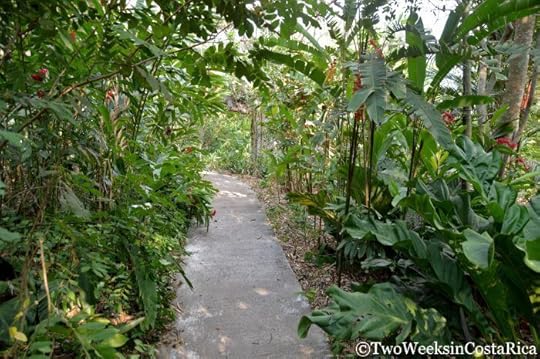
One of the paths brimming with tropical foliage
As you walk along the paths, you’ll pass through the many greenhouses and nurseries. Descriptive signs tell about the orchid life cycle and how the plants develop from seed to flower. This intricate, prolonged process will give you a whole new appreciation for these seemingly simple flowers.

One of the greenhouses with more mature orchids
Orchid Life Cycle
On our visit, we learned that the orchid life cycle starts with germinating the seeds. In nature, an orchid produces pods with thousands of tiny seeds. When the pod breaks open, the seeds fly in the wind and have to land on tree bark with a special symbiotic fungus. That fungus produces a mix of minerals and sugars, which the seeds feed on in order to germinate. To recreate this delicate process in a lab, the Botanical Orchid Garden uses glass flasks with agar jelly to mimic the mineral-sugar mix. After being in the flask for eight to 12 months, the seeds begin to germinate.
After germination, the seedlings are planted in groups called communities to create stable growing conditions. They continue on like this for about a year, before being planted into individual pots. It takes another four to five years for the plants to reach maturity and, finally, flower. As you look around the different greenhouses, you’ll see hundreds of different orchids at various stages of development. Only then will you begin to appreciate the amount of time it takes for an orchid to bloom.
While many of the greenhouses have plants that are not yet mature, the Flower Showroom has stunning orchids blooming in all their glory. The species you will see depends on the time of year, with the peak time for flowering being January through March. On our visit in mid-April, we saw many types of hybrids and also the famed Guaria Morada. This brilliant purple orchid is Costa Rica’s national flower. It is said to represent the beauty of Costa Rica’s people as well as the fragility and elegance of nature.

Flower Showroom
Facility and Trails
The Botanical Orchid Garden has a short system of paths that weave through the different areas. The greenhouses and nurseries are connected by wide, concrete or rock paths, which make it easy for anyone to get around. Near the greenhouses are a few spacious enclosures with parrots and parakeets from Costa Rica and other parts of Latin America. The garden provides permanent refuge for these birds, which have been rescued and are unable to be released back into the wild. In addition to the rescues, we saw many wild birds flying around. Some species included Blue-Gray Tanagers, wrens, robins, and various types of green parrot. If you’re into birding, the garden is a great place to spend the day.

Parrot enclosures along the paths
On the other side of the property is a longer concrete path that winds around a large pond and children’s play area. The play area, with a swing set and slide, is really unique. It’s completely made out of wood and looked to be locally made. If you have kids, they will love it.

Fun playground
The property has a small gift shop where you can take home your very own orchid plant. There is also an on-site restaurant, which overlooks the garden. We weren’t able to try it, because of a private party going on, but the menu looked great and we have heard good things about it.
Visiting the Botanical Orchid Garden
Peak time for flowering is January to March. If you’re not visiting then, it might be worth a call beforehand to see what is in bloom before you make the trip.
Hours
Tuesday through Sunday, 8:30 a.m. to 4:30 p.m.
CLOSED MONDAY
Cost
Foreigners: ₡6,000 (about $12) for adults, ₡3,000 for children (about $6).
Nationals: ₡3,000 (about $6) for adults, ₡2,000 (about $4) for children.

The Botanical Orchid Garden is a wonderful way to spend an afternoon on your way to or from Costa Rica’s capital of San Jose. Not only will this garden inspire your senses with its colorful plants, but you will begin to appreciate just how much work goes into cultivating those gorgeous flowers we call orchids.
Have you ever visited a botanical garden? Where was it and what was it like? (Email subscribers, click here to post your comment online).
Looking for more information to plan your visit to Costa Rica? Check out these posts:
How to Spend 1 or 2 Days in San Jose: After you check out the Botanical Orchid Garden, spend some time exploring downtown San Jose’s cultural sights. Our guide will tell you about the different museums and where you should stay.
Racing the Clouds at Poas Volcano: Poas is a huge, active crater volcano not far from San Jose. It is another activity that can be easily done on a day trip from San Jose
Traditional Foods to Try in Costa Rica: Know what to order at a locally owned soda with this guide to the best traditional foods.
The post Costa Rica’s Botanical Orchid Garden appeared first on Two Weeks in Costa Rica.


