
Jeff Posey's Blog
January 12, 2017
What I Learned About Animal Time Solo Hiking 3,000 Miles
On the third day, seconds and minutes and hours are meaningless.
On the fifth day, now is the only moment, and time is marked by a soft droning hum like the subliminal base notes of a wide and deep river.
This is animal time, as distinct from human time as jet airliners are from the flight of birds, as lines of automobile traffic are from the march of ants, as the flicker of fluorescent lights from midday sunlight.
In animal time, when I stop for a break, the background drone reaches a relative crescendo in the absence of the staccato cadence of walking. When I look at the sun, I do not know if it is late morning, or noon, or early afternoon, and not knowing has no significance.

Jeff Posey at Penasco Blanco, Chaco Canyon National Historic Park. Photo by Jason Myers.
In animal time, there is no urgency beyond the physical movement required to find a good spot for the night or to return to base camp if I am day hiking without my full backpack.
Hunger comes of its own accord rather than by the artificial metronome of breakfast, lunch, and dinner.
The count of days loses clarity. Is it Thursday or Friday? Have I been out six days or seven? If I am to meet someone to pick me up at the exit trailhead, I go over and over the daily events to try and construct the number of days I have been out: When the dozing elk burst from a tangle of scrub oak as I approached, like a flushed covey of quail, a function of nature that threatens heart failure to a marauding human; the day two wolverines loped across a mountain meadow below me, gamboling like two misshapen golden retrievers; the first full day of my journey walking through a cathedral of white-barked aspen trees in the high angle of morning light when a tiny bird on a high-speed descent from the cliffs above nearly flew into my face, backpedaling in a frantic flutter of wings and a series of panic peeps, my eyes snapped shut in involuntary protective mode, the puffs and eddies of braking wing strokes cooling my sweaty face, and yet, even with such milestones, the number of days I have been walking—seeing and speaking not once to a human soul—is an unsolvable mystery.

Jeff Posey at Chaco Canyon National Historic Park. Photo by Jason Myers.
If my car is at the exit trailhead (always my preference), I cease to care. A day late or a day early to return does not matter.
Time, Einstein discovered, is relative, and while he meant that in relationship to speed, it also holds true to the mechanics of human time relative to the flow of animal time.
In nature, time is not a grid that defines or constrains or even compels behavior, but merely a dimension across which things change from one place or state to another.
In the absence of the metronome of a clock, time is an infinitely variable flow without momentum or resistance, without deadlines or artificial urgency, without any meaning whatsoever on the scale of seconds, minutes, and hours. There is only the relevancy of time in the macro: day and night, the progression of seasons, the changes of weather. In nature, the only time unit less than those larger macro times is measured in moments, with only the barest relation to the drone of now.
In static animal time, when you do not move through the world but remain still, time takes on a new flow, the slow progression of shadows across the landscape, the equally slow movement of stars and planets across the blue-black firmament in the absence of overhead sunlight, and the singular state of the moon, which moves to its own otherworldly cadence, a sundial of sorts across its face, the closest thing to a global timepiece of nature.

Jeff Posey approaching the summit of 14,065-foot Mount Humboldt in Southern Colorado. Photo by Jason Myers.
Returning to human time is difficult, a time lag the body resists, a grogginess that accompanies the loss of the temporary subhuman spirit cultivated during the long days of animal time, and getting back on schedule feels like a form of blasphemy against the rhythms of the real world, of real humanity, of real life.
Living on animal time makes me remember who and what I am, that my normal daily world is a mental construct that rides atop my human-animal body. Even when it fades beneath perception, I know that, given time, I can coax my animal self back into full-blown existence merely by walking a few days, a few dozen miles, alone in the wilderness.
I have solo hiked and backpacked more than 3,000 miles over a couple of decades, without timepiece or flashlight or weapon or campfire. People ask me, “Weren't you afraid?”
“Yes,” I say.
“Of wild animals?”
I shake my head. “Of people.”
I have been mortally terrified on my long walks only three times. The first was coming out of the white-columned cathedral of aspen I mention above, the trail crossing an exposed shoulder of rock, when I heard a zip and crack of a bullet, followed by drunken laughter. I crabbed backward and climbed up and around the shooters, never letting them know of my presence, never giving them a clear shot at me. “Hey!” I imagined them saying to each other, “See if you can hit that idiot walking out here all by himself!”
Another was after I crossed the spring-swollen Gila River, sitting beside the roaring water on a rock drying my reddened legs and feet in sunlight. Two men appeared suddenly behind me, having walked up the creek bank from behind. They looked like human animals, bedraggled and unkempt with low-tech hiking gear and boots made for working and not hiking, each with a rifle and holstered pistol. They regarded me like I imagined a predator might see me, nodded without a word, and continued slowly downstream, occasionally looking back as if keeping tabs on me. When they were out of sight, I skedaddled, quietly bushwhacking a mile off the main trail, careful to leave little evidence of my passing. I did not see them again.
And finally once near tree line hiking the continental divide trail in Southern Colorado when I caught a whiff of sweet pipe smoke. I stopped and turned a slow three-sixty, seeing nothing in the first two times, but then on the third I saw movement, a swish of the tail of a horse that had been led into a tumble of boulders among a tangled nest of Gambel oak. The hairs on the back of my neck prickled as I walked the open ground, imagining a pipe-smoking hunter watching me through his scope, hoping he did not succumb to a homicidal twitch of his trigger finger.
There were dozens, maybe hundreds, of other times I experienced lower-intensity terror not related to humans other than myself, but those are the stuff of other stories.

The Next Skywatcher by Jeff Posey at Upper South Colony Lake, elevation about 12,000 feet, below Crestone Needle, in Southern Colorado.
See Books by Jeff Posey at Hot Water Press.
The post What I Learned About Animal Time Solo Hiking 3,000 Miles appeared first on Jeff Posey.


August 30, 2016
Chaco Canyon Peñasco Blanco Trail: Double Anasazi Payoff
Peñasco Blanco is the westernmost Anasazi great house ruin in Chaco Canyon National Historic Park, New Mexico. I highly recommend experiencing the two big (and very different) payoffs of walking to Peñasco Blanco.
It’s hard to beat Wikipedia’s introductory description of the place:
Peñasco Blanco (“White Bluff” in Spanish) is a Chacoan Ancestral Puebloan great house and notable archaeological site located in Chaco Canyon, a canyon in San Juan County, New Mexico, United States. The pueblo consists of an arc-shaped room block, part of an oval enclosing a plaza and great kiva, along with two great kivas outside the great house. The pueblo was built atop the canyon’s southern rim to the northwest of the great houses in the main section of the canyon. The building was constructed in five distinct stages between AD 900 and 1125. A cliff painting (the “Supernova Pictograph”) nearby may record the sighting of a supernova on July 5, 1054 AD. —From Wikipedia
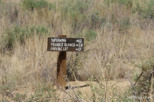
The Peñasco Blanco Trail leads you on an eight-mile round-trip hike that rewards you with two big payoffs, one obvious and well-signed, the other much more subtle.

This Post is Brought to You By
The Next Skywatcher by Jeff Posey

"You will never see the Anasazi the same way again."
If you like historical fiction, download your free ebook now
(No signup. No hassle. No price!)
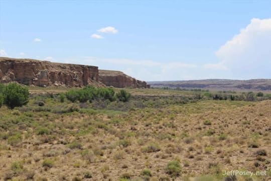
Big Payoff #1: Peñasco Blanco's Infamous Supernova Pictograph
The infamous supernova pictograph is just across Chaco Wash at the base of West Mesa, at the top of which is Peñasco Blanco. A sign marks the spot, so it's hard to miss. If you cross Chaco Wash at the wrong place, though, you could miss it, and when it's dry, it can be tempting to just bull through the growth along the wash and cross where you wish. It's best to stay on the trail as best you can (it can be a little indistinct at times near the wash), and aim for the cliff overhang in the second photo below.

The red paint is surprising. All other rock art I've seen in the canyon is pecked, not painted.

It's not as high as I had imagined it would be, about twenty feet from the base of the cliff. With a tall home utility ladder, I could have touched it, although footing for the ladder would be dicey and touching such an iconic ancient artifact is a no-no. (And anyone who carried a twenty-foot ladder four miles across the Chaco Canyon floor would be...well, both strong and crazy.)
I've twice tried to get to this place, and each time a flooded Chaco Wash prevented me from getting to the supernova pictograph and Peñasco Blanco. But this time, the wash was dry and we crossed easily without getting our feet wet.
We saw dozens, hundreds maybe, of similar overhangs with flat or suitable surfaces on the bottom side. But we noticed no markings of any kind.
Why did the Chaco Anasazi choose this place? Why did they use red paint, when all other rock art in the park is pecked into desert varnish? Does this really depict the Crab Nebula Supernova of 1054, or is it of something else?
Like most things Anasazi, we will never know for sure. But we're modern humans, which means...we like to speculate and pretend that we know.
Strong circumstantial evidence points to the pictograph being a depiction of the 1054 supernova. The crescent is the Moon, the star shape to its left the supernova, and the hand (life-size) is taken to indicate that the site is sacred. Calculations of the Moon's orbit back to 5 July 1054 have shown that the moon was waning, just entering first quarter. These calculations also indicate that at dawn on 5 July 1054 in the American Southwest, the moon was within 3 degrees of the supernova, and its crescent oriented as on the pictograph (provided the pictograph is viewed looking up with one's back to the cliff, as the authors of the pictograph most likely did). With the apparent width of the moon being about half a degree, this pictograph comes basically as close as it possibly could to being a true scale rendition of the 1054 supernova seen in conjunction with the waning moon. —From "Solar Astronomy in the Prehistoric Southwest," High Altitude Observatory, by by P. Charbonneau, O.R. White, and T.J. Bogdan.
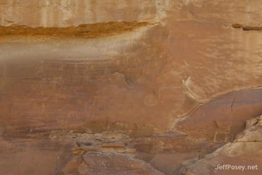
What I failed to see (and photograph) below the paintings was a faint image of concentric rings with flames erupting from one side. This photo shows it, though it's faint (bottom of the photo on the vertical face below the three red images):
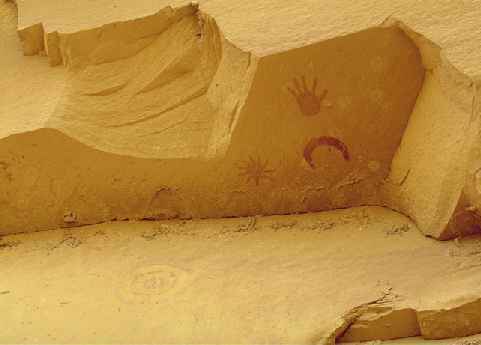
Photo by Ron Lussier courtesy Astronomy Pomona.edu
On the nearly vertical cliff face below the supernova a Sun-symbol can be seen, painted in pale yellow over a much faded red background. This, combined with a clear view on the mesa top to an eastern horizon suitable for calendrical purposes, might well indicate that the site was also a solar-observing station. From there, the Peñasco Blanco Sun-priest perhaps first noticed the supernova prior to a sunrise observation. Given how rare such an event must have been, it is then conceivable that he might have wanted to record the event. —From "Solar Astronomy in the Prehistoric Southwest," High Altitude Observatory, by by P. Charbonneau, O.R. White, and T.J. Bogdan.
Here's a great field sketch of the Halley's comet portion of the pictograph by Peter Faris.

Field sketch of Halley's comet pictograph, Peñasco Blanco trail, Chaco Canyon, NM. Peter Faris, 1997.
I recommend The "Rock Art Blog" by Peter Faris, especially his post from 2010 titled "Halley's Comet Pictured in Chaco Canyon," where I found this sketch.
Note that everyone is not convinced this shows the Crab Nebula Supernova event of 1054. Richard L. Dieterle of the University of Minnesota believes it depicts a different alignment of celestial objects on another date that was only a few months before a flyby of Haley's Comet (and the Battle of Hastings in England).
June 21, 1066, when Morning Star aligns with the radial image, the moon aligns with the crescent, and the Pleiades align with the hand. —"Is the Chaco Canyon Rock Art a Star Map Showing SN 1054?" by Richard L. Dieterle on HotcakEncyclopedia.com (a collection of Winnebago history and legends).
Regardless of how you interpret this pictograph, combined with the second big payoff, this strongly suggests some really powerful people in the Chaco Anasazi world built and lived in the Peñasco Blanco complex.
(RELATED Author Note by Jeff Posey: "Mysteries of the Chimney Rock Anasazi Observatory")
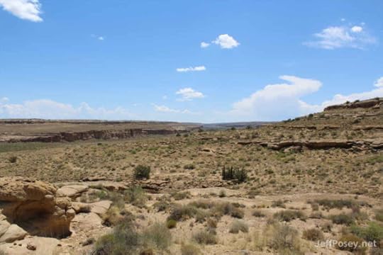
Big Payoff #2: Skybox View of Downtown Chaco
The second big payoff is this grand view of "downtown" Chaco from the Peñasco Blanco ruin atop of the mesa above the supernova pictograph. You can see all the way from Pueblo Alto on the the left (north) to South Gap on the right, with the downtown complex in the center and Tsin Kletsin on the far horizon:

The ruins in the distance are hard to see at first. I didn't realize they were visible at all until I used my binoculars, and then I could pick them out with my naked eye. Under each red arrow are dark-brown structures that are the remnants of the Anasazi buildings (except for South Gap, which is a canyon, not a ruin).
A thousand years ago, these buildings would have been plastered with a sand mixture that gave them a buff-white color. They would have shone like moonbeams.
Can you imagine the power of the person or clan that commissioned Peñasco Blanco? They were like the rich family that buys the private box on the fifty yard line of the Super Bowl. Except, in addition to friends and relatives, they would have been accompanied by astronomers who watched and recorded (even if only in their memories) celestial events. And instead of football, they would have watched the comings and goings of participants in all kinds of ceremonies and special events.
From this vantage point, if you had good eyesight, you could see the processions of pilgrims arriving and departing through South Gap, and the lines of people marching from the north along the Great North Road to Pueblo Alto, and thence down into the canyon by way of the staircases cut into the cliff stone.
Given this impressive view and the supernova marking beneath it, Peñasco Blanco must have been a particularly powerful place.
Of all the sights I have seen in Chaco Canyon, this is the one that made the biggest impression on me. If you can walk eight miles through occasionally rugged territory, I highly recommend it.
(RELATED Author Note by Jeff Posey: "Out of Chaco: The Great Anasazi North Road")
Peñasco Blanco: A Trail Guide
It's usually best to start with a map:

Courtesy National Park Service
The trail profile:

Courtesy Hiking & Walking
I hiked this trail with my buddy Jason Myers, and while it is only modestly difficult at times, it is eight miles round trip or more (especially if you thoroughly explore the Peñasco Blanco ruin) and takes four to six hours to fully enjoy. As the trail profile shows, the stretch from the Supernova Pictograph to Peñasco Blanco is the steepest and most rugged.
In the summer, when we did it, essentials are: sun hat, sunglasses, sunscreen, lots of water, a few trail snacks, and good boots. We both wore shorts, and that worked fine. Rain threatened the afternoon we were there, so it's a good idea to have a rain shell handy. Other than that, you will likely want binoculars and a camera.
Petroglyph Spur
A side-spur to the Peñasco Blanco trail that adds only a few steps to your journey takes you along a low cliff face that is sporadically covered with rock art.

Rabbits! More than I've ever seen before in the canyon. I kept watching for rattlesnakes thinking they would be feasting on them. But I didn't see or hear a single rattle.

Wait, the book says.... Jason kept looking at the book and then at the petroglyphs. "I can see them better in the book," he said. For many (most) of them, he's right. They can be rather faint, and many are easy to miss.
Sometimes Anasazi rock art looks like kids were just playing around. Why is it they could paint such wonderfully advanced images on their pottery, but their rock art so often looks as if it's made by a kid with Attention Deficit Disorder who didn't take their medicine?
There may be a genuine answer: Women did the pottery, while men tended to such important tasks as tapping rocks against cliffs.

What if a gifted Anasazi potter girl decided to try her hand at making cliff art? What if that is why the Supernova Pictograph is so much better? Is the red hand female?
Do you think the Anasazi saw themselves as lizards without tails? That's what many of their humanoid pictographs look like.
Or...what if the Anasazi themselves did not make these images? What if, say, the Navajo or Ute did, and they thought of the Anasazi as magical lizards? As usual, we will never really know because you can't precisely date rock art.
More lizard people. And one five-toed Bigfoot.
I get the impression that when one person started banging on a cliff to make these marks, everybody else around joined in, cramming as much as they could into one little area, and ignoring perfectly good similar places just feet away.
That's a pretty fine spiral there right of center. This panel looks more professionally done than some of the others. A more skilled rock-tapper must have done this one (a woman?).
In case you get turned around, the Park Service gives you a reminder.
Second Half of the Trail to Peñasco Blanco
Just when you begin to tire of childish Anasazi rock art, you look ahead and see the dark ruins of Peñasco Blanco on the horizon, though it's still quite a long walk to get to them.

The Peñasco Blanco ruin reveals itself high on West Mesa. Notice it's not just those dark piles to the right...they continue for quite a ways to the left, too, though they are just barely visible here.
After you cross Chaco Wash, you see the supernova petroglyph. And then the trail starts climbing....

Some bizarre rock foundations in the cliff below the ruins. The trail goes right up and through them.

Sometimes you do indeed need those rock cairns to show the way when the trail is hard to see.

In the middle of the day, the light reflecting from the light-colored stone is blinding (wear sunglasses and a good hat).

Even when you can see it really well looming above you, there is a lot of walking left to do. I got the impression they designed it this way, forcing you to look up at it for a long time before you actually get there. It builds anticipation, which increases the payoff of getting to it.

I knew Pueblo Alto lies due east on the horizon from Penasco Blanco, but we weren't yet high enough to see it.

The ruins of Penasco Blanco rise like a dark memory from the past.

A wide-angle view. It's surprisingly large and is hard to get a full appreciation of the layout and scale once you get closer than this.

See Jason in the doorway? He hid in the shadows like a lizard while I clambered around like a rabid coyote.

This remnant of a wall with a buttress hints at the fine stone work and strong architecture of the Anasazi.

Jason in the shade.
I kept looking at that doorway or window where he stood. You can see the intentional squaring-off at the bottom. But the top? It looks like the Hulk went blasting through there.
But there was no sign or scent of a big green man. "Smells like rock," said Jason.

Notice the stone work here. It's much more chaotic and haphazard than in other places.
What does that mean? Did the head of construction get sick, and his incompetent apprentice took over for a while? Or was a different clan in charge of building this section, and they didn't care as much about the design?
Ignore Jason's back. He's there only for scale, anyway (hey, something has to justify his existence).
What I really like about this photo is that it shows the curvature of the Peñasco Blanco structure. Unlike any other complex in Chaco Canyon, Peñasco Blanco is oval-shaped (see aerial photo toward the bottom of this post).
What that tells me is that this was a master-planned building. Somebody with the whole building design in mind was in charge.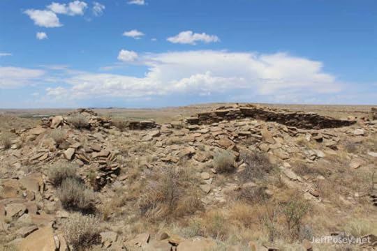
Most of Peñasco Blanco is rubble. You can put your hands on the fallen building stones and feel the shaped faces and imagine the rough hands that worked them.
This also gives you an idea of what most Anasazi ruins look like: mounds of unorganized stone with a remnant spine that hasn't fallen over in a thousand years.

Look how impressively square these walls are. How they tie together. How straight they are. The courses of stones of different sizes.
This proves a very high degree of building skill. The master stone workers who built this section were at the top of their profession.

This long wall gives a hint of the majestic nature of what this looked like in its prime.
And these holes gave me long pause. I studied them from both sides. I have an impression than they were not intentional doorways or openings, but that someone had breached the wall by dismantling these little sections. A sign of warfare?
Violence certainly happened at Peñasco Blanco. There is compelling evidence of murder and mayhem, including cannibalism at the site. (See in particular Man Corn: Cannibalism and Violence in the Prehistoric American Southwest, by Christy G. Turner II, pages 95-111.)
Knowing of such extreme violence lends a somber air to the ruins, though, throughout most of its history, it must have been a relatively peaceful place, just as it is now.
(RELATED Author Notes by Jeff Posey: "Were the Anasazi Cannibals?" and "Were the Anasazi Nazis?")
If you like historical fiction,
Try The Next Skywatcher by Jeff Posey

"You will never see the Anasazi the same way again."
Download your free ebook now
(No email signup. No download hassle. No price!)

You can see two stories at least. When you reconstruct that in your mind across all the ancient foundations, you begin to feel overwhelmed by how large this place was.

There's another suspicious hole knocked into the wonderful Anasazi stone work. Could more recent pot-hunters have caused this kind of damage?
Look at the different stone style, from small stones of the same size along the layer with the hole, to alternating layers of large and small stones up top. Do you think they started building before the guys with the large stones arrived? Maybe they were delayed along the way...diverted to Pueblo Bonito, perhaps, by the big man in charge, or they stopped to harvest a seasonal explosion of rabbits.
This is where you get that spectacular view looking east toward "downtown" Chaco. I kept looking away from the nearby ruins and gazing into the distance, imagining that view when Chaco was at its peak.
At night, could you have seen the light of fires at each of those places? During the day, would plumes of smoke from cooking fires have marked the spots? Would the fields of crops along the canyon floor and even up on the mesa tops have stood out a darker green during the growing season?
Might the big man in charge of Peñasco Blanco have employed a few sharp-eyed boys to watch and notify him of anything worthy of seeing with his own eyes?
When it's time to go and you descend only a short distance, all of those "downtown" Chaco structures go out of sight.
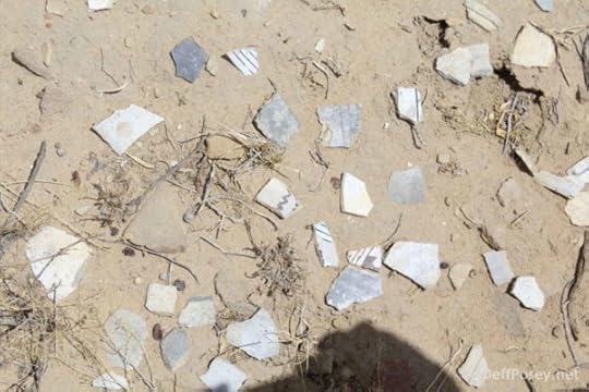
But you're rewarding by this collection of broken pottery pieces, or sherds. This looks to me like a pile made by recent visitors. It's so tempting to take such a thing, but the guilt of responsibility rises hard in the chest, and even if you pick one up and put it into your pocket, most of them probably wind up back in this pile.
Even in this tiny sample of pottery pieces, you can see the skill of the artists. Why didn't they do more spectacular rock art? They were certainly capable.

Walk with care. The trail back can be treacherous.
On the way down, the canyon opens up. For quite a ways, no Anasazi sites are readily visible.

It's a long and sandy trail home.

Much of the trail is loose sand, like walking on a beach. Prepare yourself for that. It can be exhausting more quickly than you expect.
Casa Chiquita: Hidden Little House
The sign is clear, so you know when you've found it. But step back and eyeball back toward Peñasco Blanco, and the other direction toward Pueblo Bonito. You can see those places when you walk out into the canyon...but not when you stand close to Casa Chiquita's walls.

Who built this place? The Chaco Research Archive dates the Casa Chiquita site at A.D. 1100-1130, meaning it was built in one stage, one big effort over a single generation.
Did they have something to hide from the prying eyes of the big leaders at Peñasco Blanco or Pueblo Bonito?
Casa Chiquita has never been formally excavated. Any chance we would find evidence of the Chaco Canyon black market here? The place to go when you didn't want to be seen? Did visitors wear disguises? Was corn beer involved? How about pretty ladies?
As a historical novelist, I strongly suspect so. Human nature demands it.
Perhaps this was the headquarters of The Fat Man from The Next Skywatcher, or built in his honor. You know one of the fattest men in such a calorie-starved environment would be the guy in charge of selling vice.
End of Day Hike; Beginning of Daydream
This ends my trail guide. I highly recommend taking the time and calories to walk back a thousand years and be Anasazi in your mind for a few hours. It's great fun.
Jeff Posey at Peñasco Blanco, Chaco Canyon. Photo by Jason Myers.
This is how I spend most of my time at any Anasazi ruin—stare at things far longer than most other people. In my mind's eye, there are dozens of competing dramas going on, echoes from the past, or my own projections back onto the old ones. They ring in my ears like tinnitus. There are stories to tell.
At the end of the trail, there are scattered showers....

Fajada Butte in a summer rainstorm, Chaco Canyon National Historic Park. Photo by Jason Myers. Why is it crooked? I think he snapped it from the truck as we were driving back to camp.
"You will never see the Anasazi the same way again."
The Next Skywatcher by Jeff Posey

If you like historical fiction,
Download your free ebook now
(No email list to join. No confusing download instructions. No monetary price!)
More About Peñasco Blanco
Here's what it looks like from the air:

Courtesy Wikipedia
What did it look like when it was at its peak? Dennis R. Holloway, architect, did this digital reconstruction:

Reconstruction by Dennis R. Holloway Architect
Recommended Resources
For more information about Peñasco Blanco Trail, I highly recommend these sites:
Official Chaco Canyon National Historic Park Peñasco Blanco Trail page, so scanty it's just barely worth a page visit, but it's a good place to start.
Hiking & Walking, a wonderful collection of trail descriptions and photographs.
Wikipedia entry for Peñasco Blanco, a fair place to begin research on the ruin itself.
Slideshow by Rex Nye on YouTube, with a nice selection of photographs that scroll a little too fast for my tastes.
Chaco Research Archive entry for Peñasco Blanco, with lots of detailed information that gets pretty esoteric.
The "Rock Art Blog" by Peter Faris, especially his post from 2010 titled "Halley's Comet Pictured in Chaco Canyon."
The post Chaco Canyon Peñasco Blanco Trail: Double Anasazi Payoff appeared first on Jeff Posey.
December 3, 2015
Memoir of a Rookie Anasazi Potter
A few summers ago, I had the incredible experience of a three-day Anasazi pottery workshop taught by Gregory S. Wood, ArchæoCeramist, at Chimney Rock National Monument near Pagosa Springs, Colorado.
Wood is renowned for using only materials, tools, and techniques available to the local Anasazi at the time they fired their own pottery in the area. He further specializes in recreating the exterior painting styles. All of which together makes him the greatest living Anasazi potter.
I had never taken a pottery class or attempted working in clay other than the typical childhood obsessions with mud pies and unspectacular attempts at making adobe bricks for Cub Scout projects.
In fact, for this workshop, I really only wanted to watch and take notes.

Click on the cover to learn more.
Instead, as you’ll see, Greg and my buddy, Raymond, insisted I get my hands far too messy for note-taking.
That’s also a disclaimer: What I write here is from memory and memory alone (when external citations aren’t given). One should never trust the undocumented memory of a novelist. But I promise to try my best, with an aim more toward accuracy than precision.
When I searched for and signed up for this workshop, I knew I wanted to write a historical novel based on an extraordinary Anasazi potter. As I write this Author Note, I’m in the final editorial stages for Thirteen Spiral Stars, first book in The Last Skywatcher Triple Trilogy Series.
In the story, Sooveni, a young Anasazi potter in the year 1094, fires thirteen pots each with thirteen symbols of spiral shooting stars, with apparent magical properties. These pots, as you can imagine, cause enormous troubles for Old Tuwa, Master Skywatcher at the Twins, and Vingta and Uva who have to do all the dirty work of protecting everyone from the rampaging warriors of the High Priest in the sacred canyon—who, of course, wants the mystical pots for himself and his wives.
It’s a continuation of The Next Skywatcher, prequel to the The Last Skywatcher Triple Trilogy Series.
The first three books of the triple trilogy are historical thrillers with a hint of romance, the second trilogy will be murder mysteries, and the last three will be a subtle reflection of the first trilogy and reveal the true Last Skywatcher.
Modern Anasazi pottery camp
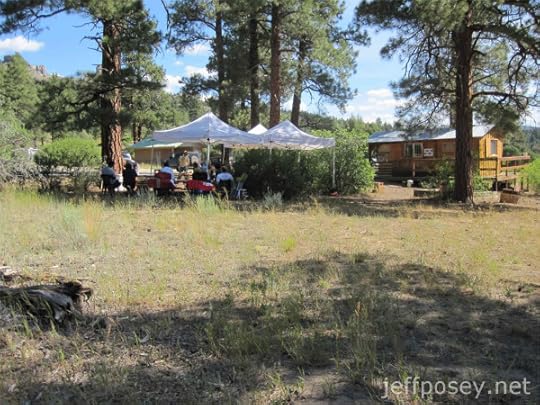
These shade tents were our home base for three days near the visitor’s center at Chimney Rock National Monument as we started the process of making Anasazi-style pottery from, literally, scratch.
The first morning, the workshop class of about twenty people followed Master Greg to a place where coarse clay had been exposed by erosion. He instructed us to scratch up a few pinches, spit in our hands, and see if we could work the resulting clay into tiny worm shapes. When you can make good wiggle worms from any dirt, it’s potential pottery clay.
In geological and soil-science terms, it needs to contain the right proportion of clay, sand (filler), and feldspar (a common but complex mixture of metal oxides that are the main vitrifying or fluxing agent of the ceramic). My first degree is in geology, so I can kind of geek out on this, but I’ll spare you.
Gregory S. Wood, modern master Anasazi potter

This is Master Greg demonstrating the basic tools of Anasazi pottery making: yucca-leaf paintbrushes, twigs for use like toothpicks, and smooth river stones for polishing away imperfections.
Other than fingers and fingernails, those are about all you need to work directly on the clay that becomes pottery.
Circle of influence on Anasazi pottery

Being an ArchæoCeramist, Greg likes to overthink things in the ways of both theoretical and practical master of the craft.
In other words, we think as much as we simply do and feel in his workshop.
This diagram by Greg shows the major influences on Anasazi pottery. It’s worth rewriting in outline form (helps me think about it).
Cultural versus Natural
I like the implication of the two big divisions. To the Anasazi, or any native ancient tribes or groups, their only direct clear and true outside influencers are natural forces external to them: Weather and food sources and rockslides and thunderstorms and animals and rivers. Each of these affected them greatly, yet none were animated by human spirits. So they must have their own, non-human origins of power.
The way they interpreted and understood the natural world of those non-human sources of power became their cultural world.
There must have been constant power interplay between what would appear to some as merely the physics of the universe and to others as intentional acts of the gods.
There would be those who believed the sun would come up the next day only if they performed the necessary daily rituals, and others who knew it would come up anyway.
Cultural
Soul
Society
Craft
Art
Fire
Technology
Fuels
Kilns
Natural
Earth
Geology
Clay
Temper
Water
Environment
Mountains
Desert
The primary technologies of making Anasazi pottery were the fuels they could use to reach temperatures hot enough to fire clay, and the kilns they built to concentrate and retain that heat.
In the Chimney Rock area, the choices of fuel are: juniper, piñon, Ponderosa pine limbs, scrubby Gambel oak, alder and cottonwood if you’re willing to follow a stream long enough to collect a load, other shrubs such as rabbitbrush and mountain mahogany, and any remnants of agriculture, such as corn cobs.
Expert potters know which types of fuel burn hottest and longest, or start the firing process most efficiently for their circumstances.
In our fire, most fuel came from juniper with about a third oak, and less than 10 percent from other scrap wood easily at hand.
The technology of the kiln is what would take the most practice, experimenting, and skill apart from shaping and painting the pots themselves. Almost anyone could gather wood. But to build a trench kiln and manage the firing took great skill.
But I get ahead of myself. In the workshop itself, after we gathered a few samples of local clay, we actually worked material Greg brought with him. I believe he said he had collected it in the vicinity of Mesa Verde National Park, eighty miles to the west.
Only a deranged Anasazi potter would haul clay that far back in their day. Not that it didn’t happen. It could have. A deranged potter could be very entertaining in a good novel.
Grinding clay the Anasazi way
Grinding clay is tedious. It doesn’t go quickly. There’s not really much technique involved. It’s just rocking and dragging a grinding stone over hard fragments of clay, pulverizing them into powder.
I can imagine an Anasazi potter spending days, weeks, maybe the first half of each moon cycle just grinding clay into a consistency that would make good pots.
A lump of wet clay
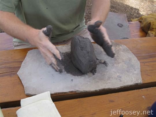
Add a little water, and you’ve got a lump of clay. Anyone who made mud pies as a child will know the feeling.
Potters, I learned, add water not so much by formula as by feel. Add a little water, and mash it up with the clay. If it’s too dry, add more water. If it’s too wet, let it sit a while and dry off. (We were above 7,000 feet elevation in the summer, and the humidity was very low, in spite of some afternoon sprinkles. We constantly battled clay that dried faster than we could work it.)
Making a thin layer of clay

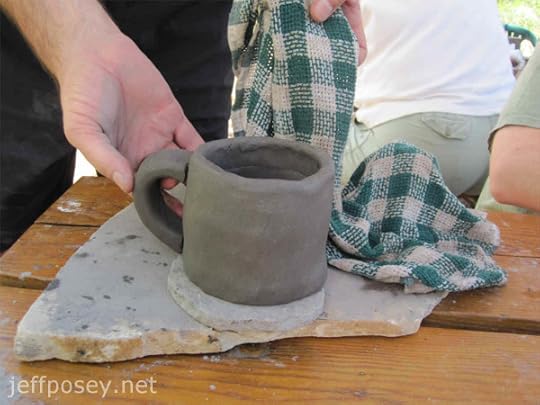
Most of the workshop class chose to attempt mugs, and I followed their majority lead. As I said, I’ve never worked clay in my life.
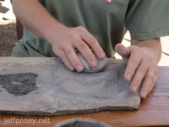
First, Master Greg said, mash out a layer of clay to make the base of the mug. It had to be thin, but not too thin (try getting a master potter to explain that to you—I just showed him and he shook his head: “Thinner.”)
So, of course, I made mine too thin and had to start over again.
A vessel bottom cut to shape
Using my best freehand skill of dragging a toothpick-like pine splinter in a perfect circle, I boldly cut out the base of my mug on a small, flat working stone. Not bad, except for that little pointy pooch on the right.
What’s next? I had to ask because by now, everyone else was way ahead of me.
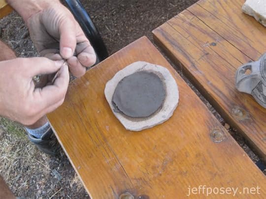
Scoring the vessel base

This time I cheated and used a modern toothpick to make scores around the edges of my mug. These help the first row of clay that becomes the side of the cup stick firmly to the bottom.
Rolling out the clay
Remember the tiny wiggle-worm dirt I mentioned in the opening? This is the same thing, but at snake-size scale.
This part of the assignment: Roll out a consistently textured and sized log about double thumb thickness.
Making clay rings to stack into vessels

And then you make a bagel or donut shape by connecting the ends of that snake of clay.
I’m worried mine are too skinny at this point. I have no idea what I’m doing. I’m just watching and following along.
Of course, I end up having to start over and make a thicker ring. At this rate, everyone else will be firing their pots while I’m still working with mud.
Rookie Anasazi potter at work

After I scored the bottom of my first bagel and mashed it onto the base, I ran my hands round and round, squeezing and shaping to make the bottom sides of the cup.
Going around and around like this, dipping your fingers into mud (it started as clear water for dipping, but soon turned into soupy mud) to keep it wet and workable, you feel and gently work the whole piece into the right shape and thickness.
Stacking rings of clay to make a vessel

Another bagel of clay makes the second tier of the mug sides.
Being so bad at it, I could appreciate the skill of those who could shape symmetrical, smooth, wonderful little bowls and mugs. I felt more like a kid making a mess.
Anasazi Jeff potter hands

This is why I have no notes from that day.
For a word guy like me, it felt like being in handcuffs.
Getting a handle on it
See how thick my mug is? And how variable the thickness and irregular the container? That is a sure sign you’re not seeing a master potter at work.
But look at my handle! I’m proud of that. I mean, it really looks like a mug handle!
I got lucky. And then kind of mashed it out of shape trying to get it to stick to the body of my mug because I’d let the surface of the clay dry too much.
Sigh…this is not easy.
I can already see that only masters of the craft could do it well and keep the process going at the right pace to end up with a quality product.
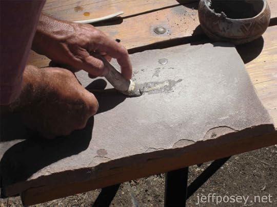
Applying the slip coat

To the raw or main body of the pot, we covered it with a soupy mixture of extra-fine clay called “slip,” because it kind of slips right over it, fires to a glaze, and gives you a much better base for applying the final artistic layer of paint.
Drying the slip coat

Did every Anasazi potter do this? Apply the slip, and then walk around with their hand in the pot or mug while it dried enough to be able to set it down without sticking to anything?
My arm got tired. A fly discovered I was vulnerable and enjoyed terrorizing my left side. Everybody else already had theirs sitting and drying while I walked around like a mute ventriloquist with a mug-shaped puppet.
The old Anasazi potters would have laughed at me. I would have been valuable to them only for entertainment. Maybe they would have given me scraps of food to teach their children how not to make pots.
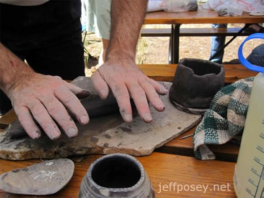
The Master burnishing a dried pot

When you’ve applied slip the right way and let it dry, you get a milky, even color like Master Greg shows here. In this photo, he’s demonstrating how to “burnish” it with a river-polished stone.
Burnishing smooths and evens out where the slip has clumps or drip marks.
To get mine to look this smooth would take months of burnishing. Maybe years.
Anasazi Lunch!

Yay, lunch!
Everyone knows Anasazi potters’ preferred foods are Kalamata olives, bean sprouts, and humus. And pita bread, not shown (you know how it can be shy sometimes).
So that’s what I had for lunch.
Making a yucca-leaf paintbrush
While our pots are air drying, it’s time to make paintbrushes. From dried yucca leaves, we stripped away long pieces of fiber, splitting them into several thicknesses.
Then we soaked the ends in water while we burnished the slip-covered pots and mugs, and then used this tool—an elk horn cut and polished smooth from use—to mash the soaked ends of the yucca to make them pliable enough to use as tiny paintbrushes.
Testing a new yucca-leaf paint brush
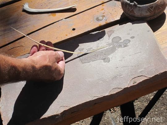
When they’re ready, you have a long, limp piece on the end like this, and then you can cut it to make a stiff brush, or to ensure the ends aren’t ragged.
Anasazi black paint source: Rocky Mountain Bee Plant

We did not gather the plants and make our own Anasazi ink from the Rocky Mountain Bee Plant.
 Cleome serrulata Licensed under Public Domain via Wikimedia Commons
It’s a beautiful plant that can become a wide bush as tall as a person under the right conditions.
Because it takes so long, Greg harvested and boiled the whole plant down to a paste that became genuine Anasazi paint.
When it’s first applied, it has a deep purple color, but after it’s fired, it’s charcoal black.
An Anasazi paint pot

With a few drops of water and some dried Bee Plant paint, Master Greg mixes it in what would have been a highly valued paint pot hollowed into a flat river stone.
When a potter moved, this is something they would likely have deemed worth the effort of carrying.
The master’s steady hand
Master Greg demonstrates the careful and tedious application of paint using a thin yucca paintbrush to make genuine-style Anasazi patterns.
Mistakes are hard to fix and essentially cannot be tolerated. You have to be like jazz guitar legend B.B. King, who I heard once say in a radio interview that he never made what he considered mistakes because he would repeat the “mistake” and incorporate it into the design of his music.
Anasazi pot painters had to have a philosophy much like that.
Basic tools of the Anasazi potter

I mentioned these before, but here they are in close-up, the basic tools for working and preparing a pot.
There is a smooth burnishing stone, a thin stick for scraping and poking, and straw-like yucca paintbrushes. I flagged my paintbrushes with tabs of masking tape to make them easier to find when they blow away, which they’ll do in the lightest of wind.
Toolkit of the Anasazi Master Potter


These images are of Master Greg’s Anasazi potter toolkit, a mishmash of modern and ancient goods. The modern materials are mostly for teaching, and the ancient materials are what he uses for making pots.
I won’t even attempt to list all that’s here, but I will point out the scrapers made of dried gourd in the bottom image, slightly right of center. These are used to scrape out the inside of bigger pots or ollas. We didn’t use them for mere mugs.
Anasazi Jeff’s pottery workbench
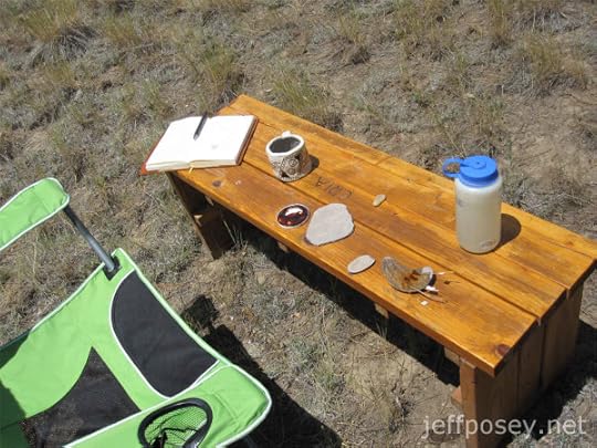
This was my open-air pot-painter’s workshop. Greg instructed us to find a place where we could work quietly while painting our mugs, and I wanted to be away from the group and take my time.
View of Chimney Rock from my workbench

As you can see, I faced the columns of Chimney Rock from where I sat painting my mug. When I squinted and ignored the sound of modern humans nearby, I felt like an Anasazi. Sort of.
Anasazi Jeff’s beginner potter’s painting style
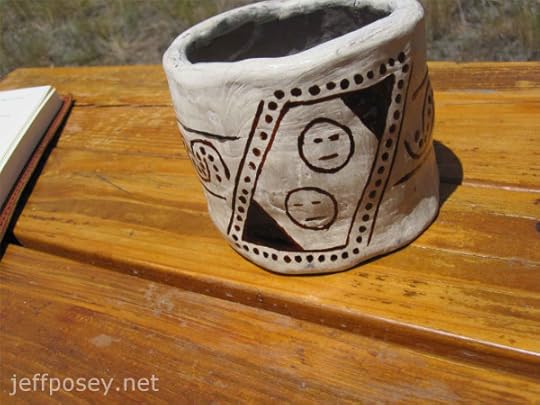
I decided to make my own design rather than attempting to recreate genuine Anasazi styles.
As usual, I had no idea what I was doing. I overheard others refer to this as “those not-smiley faces.”
I didn’t explain myself, but I wanted my own rendition of Másaw, traditional god of the underworld, caves and dark places, from the legends of Anasazi descendant cultures and the Maya.
Másaw is described as having slits for eyes and mouth, no nose, and has a flayed head—meaning it’s been skinned. Not pleasant, I know.
If it offends you, look away.
Superior craftsmanship of the Master’s Anasazi pottery

Compared to mine, this mug and its painted design is a work of genius. Which, of course, it is, being by Master Greg.
Mine, on the other hand, is the work of a beginner. I’m not ashamed in the least. But I do recognize the stark differences in quality between the work of a master and the work of a first-timer.
True Anasazi pottery shards

A fragment of genuine Anasazi pottery with an enduring design, a tentacle curling into a spiral.
After painting my own mug, it’s easy to see and imagine the individual strokes of the painter.
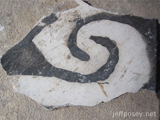
This fragment is much whiter in background (better slip?) and the paint is much darker (better paint?).
The interlocking spiral design reminds me of a neural synapse, where biological nerve cells come together but don’t quite touch, and neurotransmitters must diffuse across the boundary.
The Anasazi likely would not have made that connection.
I wonder what this meant to them?
The pit of the first fire

The firing of Anasazi pots is as painstaking a process as creating the pots to be fired.
First, a small trench or pit is dug, measured here to accommodate a cross-log to be used in the second firing.
The first firing is simply like a campfire in a pit lined with stones to create a deep bed of coals.
Fire pit at Chimney Rock
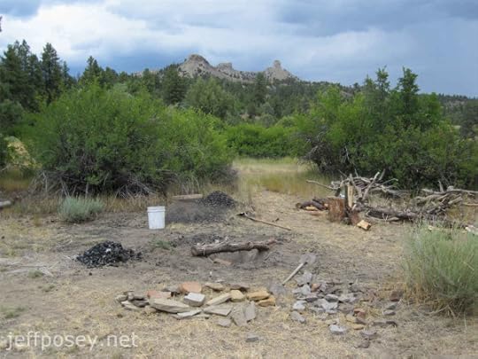
This is the pit-kiln location below Chimney Rock. A thousand years ago, this scene might have looked much the same. Without the white bucket, of course.
Drying the “green” pots

While the fire burns into a bed of coals that Master Greg says needs to be six- to eight-inches deep and not smoking, we further dry the pots sitting on small flagstones that will be used as “furniture” in the kiln.
Furniture is the flagstones that will be placed directly onto the coals with the green pots set on top without touching the smoldering wood below.
Preparing the bed of coals

This is Master Greg placing the flagstones onto the coals to be the furniture that supports the pots.
Notice his thick gloves. The Anasazi would not have had such a thing. It’s a hot job. That fire is radiating heat at a very high temperature. But you have to work fast. When the coal bed is ready, it’s ready.
The Master placing the first pot to be fired

Master Greg places the first pot.
No pot or mug can touch the coals or other pots or mugs.
Protecting the pots with pieces of old pottery

After all the pottery to be fired is stacked onto the furniture, they are carefully covered with large, old pottery shards.
Another fire, as you’ll see, will be built over the top of these pots, and the shards protect the new pots from collapsing firewood.
Again, I can appreciate how much goes into doing this correctly, and how much labor is involved in working directly over a very hot fire. Timing is still crucial.
The lower bed of coals must still be burning very hot when the second fire is built over it.
Old pottery shards over new pots

This how the pit-kiln looks prior to stacking wood over it for the second fire.
The Master honoring the spirit of the pottery

In honor of the ancient spirits of both the place and the activity of making pots like the Anasazi, Master Greg waves an owl wing over the pit, still emanating extreme heat.
A small pile of corncobs will be incorporated into the second fire to honor the spirits of the grain that sustained the Anasazi.
The center pole of the second fire

This is the center structural pole that will hold up the overburden of firewood for the second firing and protect the pots below. My buddy Raymond is helping Master Greg.
Structure of the second fire
This is the structure of sticks and wood for the second fire, carefully engineering to prevent sudden collapse onto the pots below.
The second fire is ready to light

Adorned with sacred corncobs and strips of piñon wood and tufts of grass, the second fire is ready to be lit.
The second fire is lit at Chimney Rock

The first rush of flames from the second fire. The wood is dry and hot from the layer of coals from the first fire below the furniture on which the pots being fired sit.
This must look much as it would have a thousand years ago in Anasazi time at Chimney Rock.
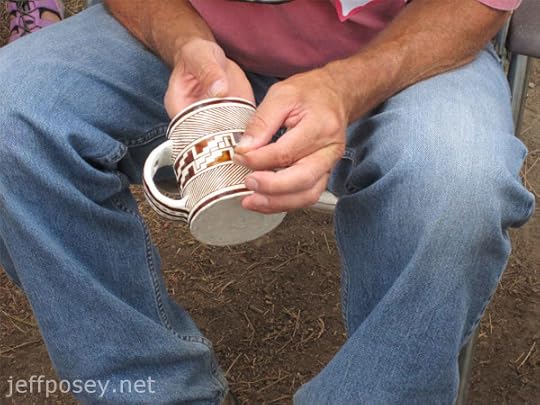
Anasazi Jeff’s and Raymond’s hot new mugs

Jumping ahead to the dramatic end, this is me (left) and my buddy Raymond (right) holding our mugs still scalding hot out of the fire.
We were too busy to take photos while we uncovered the pots and extracted them from the fire.
The sounds were interesting. Occasionally there would be a loud crack, and Master Greg would say, “Something blew.” He meant a piece of pottery had too much water in the interior of the clay and it exploded.
Both mine and Raymond’s mugs had such pockets of too-moist clay and parts were blown out. My lovely handle lost some of the bottom part.
But I’m still proud of it. It’s my one and only Anasazi mug made entirely by my own non-Anasazi hands.
 This is my mug today (with local native sand lovegrass in the background).
The color of the paint before we fired it was much richer, dark purple and glistening. Firing makes it fade. But I still like my mug. It’s one of those things I’ll keep and treasure forever.
Anasazi Jeff with the Twins at Chimney Rock

I carry that damned leather journal everywhere I go. People think I’m a Bible-toter. But my good book is the hundreds of notebooks I’ve filled in my lifetime. When my hands aren’t too dirty from making pots, that is.
This perspective of Chimney Rock, my Twins in the stories I write, is what was so special to the Anasazi skywatcher. Every 18.6 years, the full moon rises for a few months precisely between these two columns.
Near where I am standing would have been the skywatcher’s platform, or observatory, and they would have noticed and recorded in some way the slow progression of the moon and wandering stars (planets) and longhair stars (comets) against the unchanging background of fixed stars.
In the sky to the upper right would have been the location of the Supernova of 1054, the Crab Nebula exploding into a light so bright it was visible during the day for a month, and at night for a couple years—recorded by Chinese and Mesopotamian scholars and skywatchers.
All of that must have seemed like magic to the Anasazi.
Just as potters who could make perfect pots and mugs might have been regarded as purveyors of a sort of magic.
And so ends this workshop of trying to make pots like the Anasazi. If you get the chance, I highly recommend the classes by Gregory S. Wood, ArchæoCeramist, at Chimney Rock National Monument near Pagosa Springs, Colorado.
The post Memoir of a Rookie Anasazi Potter appeared first on Jeff Posey.
October 30, 2015
Pagosa 2015 Snapshots and Notes
Ah, Pagosa Springs, Colorado. I’ve been in love with this place since driving through with my parents on a family vacation in high school. At first, the attraction was cool mountains, lush forests, noisy streams, and thousands of miles of some of the best hiking trails in North America.
I’ve visited more than a hundred times since. I’ve solo backpacked more than 2,000 trail miles in nearby wilderness, and I’ve hiked another 500 or more with other people.
Now when I return to Pagosa, I see it through the foggy lens of time. A thousand years ago, this was the farthest northeast corner of the Anasazi Empire.
Twenty miles due east of Pagosa is Chimney Rock National Monument, home base of my historical novels about master skywatcher Tuwa and his astronomical observatory using a complex circle of stones and a record of events in knots and fringe in a long string record.
The mother hot spring of what is now Pagosa Springs must have been an active place (Pah-go-sah is a Ute word for “hot water”) a thousand years ago. The Anasazi outpost at Chimney Rock had line-of-sight communication with Chaco Canyon (via signal bonfires on Huerfano Mesa and Pueblo Alto), and the stone construction there is unmistakably of Chaco Canyon style.
The hot springs, a long day’s walk due east of the Twins (my historical fictional name for the dual spires of Chimney Rock), would have been a natural gathering place. Farmers from the foothills of the South San Juan Mountains—likely insulated from the rule of any High Priest in Chaco Canyon—would have known of it, bathed in its sulfur water, plastered themselves with its mineral mud.
New arrivals, ancestors of the Utes and their mountain-dwelling offshoots, would have come down to trade and take the waters.
And, of course, the elite of Chimney Rock, the master skywatcher and his monk-like acolytes and their wives and husbands would likely have made forays to the hot springs.
Pagosa Springs back in the day of the Anasazi would have been a Wild West town on the fringe between the hard-fisted rule of Chaco Canyon and surrounding wild tribes and clans.
When I tour Anasaziland, mostly desert and dry plateaus and canyonlands to the south and west, I’m struck by how foreign and different the Anasazi outpost of Chimney Rock must have been. Did emissaries of the High Priest in Chaco Canyon lobby to be assigned there? If not, what was wrong with them?
I’m not much of a photographer. I tend to get lost in moments and forget to snap the shot. I also use only a phone for pictures because I like to carry as little as possible. My buddy Mike supplements my photo collection here. He uses a real camera.
These are from my 2015 trips. I’ll add more from time to time as I dig through the digital brain of my phone from our trip in June. And I’ll add photos by others as they come in.
River, Marsh, Spring, and Ridge
The San Juan River flows like an overgrown mountain stream through Pagosa Springs and then runs west to the Four Corners area, where it turns southwest and ultimately joins the Colorado River that (sometimes) flows into the Gulf of California (also known as the Sea of Cortez) after cutting through the Grand Canyon.
San Juan River
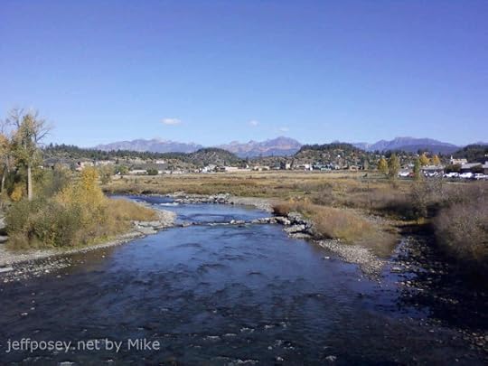
Looking north on the San Juan River toward Pagosa Peak (highest on the left) and the Weminuche Wilderness.
When I hike back into that area, it feels like I’m returning home. I’ve made at least fifty backpacking trips into those mountains, and more than double that many day hikes.
I’m a glutton for the punishment of hard wilderness walking, though five knee surgeries have slowed me down. My two-week-long, 100-plus-mile hikes are over.
I sure love looking up into that area from the river, though. I’ve been all up and down the Rocky Mountain spine from New Mexico to Montana. I’ve found places as pretty and appealing. But nothing more pretty and appealing than the San Juan Mountains of southern Colorado.
Why go anywhere else? Even in my mind, when I’m dreaming up my novels, my characters always end up somewhere in or around Pagosa Springs.
Warm River Marsh

Like pearls strung alongside the San Juan River downstream of the Mother Hot Spring in Pagosa Springs, a series of ponds begin with this one.
Faint steam rises in tendrils from the water, warm to the touch. As you walk along the concrete pathway, part of the town of Pagosa Springs River Walk, the downstream ponds cool until a finger plunged into the water detects no warmth at all and no steam tendrils rise from the surface.
Imagine the way this would stand out in winter, a haven for wildlife seeking warmth. In October, when I took this photo, a ring of green surrounded this pond, but the cooler ones to the west were already brown, giving in early to coming winter. A chorus of redwing blackbirds sang from the cattails, and the slip-trails of muskrat crisscrossed the marsh grass.
It’s a magical place.
The Ridge from the Marsh

From the river and its marshes rises this ridge of fractured shale. The river bends away to the left, eroding this black cliff. The warm marsh is also to the left.
From the top of this ridge, the view of downtown Pagosa Springs, the river, and the mountains to the north and east is spectacular.
In my mind it’s a place of drama. Because it overlooks….
The Mother Hot Spring

This is a shot (by Mike) from the ridge looking east. Just to the right of that fancy brown-topped building is the mother hot spring. The warm marshes and river are down and to the right.
Close-up of the modern Mother Hot Spring

This is what the mother hot spring at Pagosa Springs now looks like. In the old days, it was muddy marsh all around, hard to get to.
Now it’s easy to stare into the bubbly depths of what is advertised as the deepest hot springs in the world.
I like to stand on this ridge

This is the top of the ridge as it slopes west. This photo is facing the same direction as the earlier one that looks down on the mother hot spring.
That’s me at the top looking down the steep meadow that leads up to the cliff edge (just behind me).
Danielle and Vicki tuckered out before they got to the top and had to take a rest. I’ve never understood flatland lungs. I’ve always been able to go like a steam engine, thin air be damned.
But look at this place. Peeking over the ridge along which I’m standing you can see the mother hot spring and the flatland around it. That’s a powerful place to be if you want to spy on people down there.
I’ve got some imaginary drama planned for this place in The Last Skywatcher Series.
Reservoir Hill
The Pagosa Springs River Walk connects to a large town park called Reservoir Hill (as far as I can tell, it’s named that because they put a big water tank for town water up on the hill—I suppose I should give town leaders credit for not naming it Tank Hill), with miles of hiking and mountain bike trails, a meadow with a pavilion for concerts and outdoor gatherings, and a disc golf course that always seems to have at least a few people playing in good weather.
You can see it as the forested hill rising behind the mother hot spring in the photo taken from the ridge.
Cougar Bench of Pagosa Springs
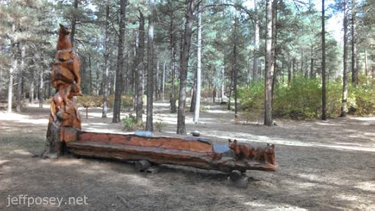
This carved bench, by artist Chad Haspels, is always a pleasant surprise.
Here’s a close-up in rather poor lighting.

The bench and carving has been recently restored, with a new coast of varnish applied. I’m glad they did that. It was getting rather worn and faded.
More here: Artwork Refurbished on PagosaSprings.com.
I wonder what artwork in wood the Anasazi and their contemporaries made in this area. Every culture, given wood and tools harder than wood (stone), has made carvings of their world. They certainly would have been familiar with the cougars (a.k.a. mountain lion and puma) in the area, some of the largest in the state.
The ancient ones would have appreciated this bench and its art.
Pagosa Peak from Reservoir Hill

From the top of Reservoir Hill is this panorama looking north to the cluster of mountains around the Fourmile Creek drainage, Pagosa Peak (12,640’) prominently to the left. I’ve climbed it twice. Failed on one other attempt.
On yet another venture, I climbed around it above tree line to get a line-of-sight to Chimney Rock National Monument (the Twins in my historical fiction parlance). I wanted to test whether a scene I’d already written could actually happen: Would a bonfire on the southwestern slops of Pagosa Peak above tree line be visible from the Twins? Yes, absolutely.
I sat for more than an hour imagining how a group of adolescent boys would do such a thing to surprise their grandfather skywatcher back at the Twins. If it didn’t happen, I would be surprised. In my fictional world, it definitely did.
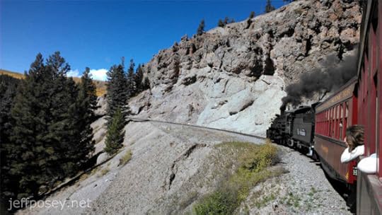
Cumbres & Toltec Scenic Railroad
The name of this railway is mystifying. Toltec? Really? They were a culture more or less contemporaneous with the Anasazi, but centered 2,500 miles to the south near Mexico City. It’s highly unlikely that any true Toltec ever walked the line that became this railway.
We rode it at the perfect time to see spectacular fall foliage color, the first week of October.
Beginning of the Line

The steam engine of the Cumbres & Toltec Scenic Railroad sits ready to haul a long string of cars up the narrow-gauge line over a high pass between Antonito, Colorado, and Chama, New Mexico.
There’s a competing narrow-gauge railway (narrow to better navigate the tight twists and loops and turns necessary to find a grade up and down which a steam engine can haul people and lumber and minerals) that runs from Durango to Silverton, the Durango & Silverton Narrow Gauge Railroad Museum (yes, it’s a museum on iron wheels and rails).
I’ve ridden both, and given a choice, I’d take the Cumbres & Toltec line, though by a bare margin. When in doubt, take both!

My lovely wife Danielle and I are ready for the ride!
(No, I’ve never been to Alaska, despite the advertisement on my cap. My mother took an Alaska cruise this summer. She got to see glaciers and whales. I got the hat.)
Sagebrush Plains and Train

Before we climb into the mountains and spot our first fall foliage, the train loops through a high plateau of sagebrush as it gains elevation.
Top speed on the train is in the neighborhood of fifteen miles per hour. And the loops are so wide and get so close to each other at the necks of the loops, it’s often tempting to jump off the train, hike up a few dozen yards to the higher track, and wait for the slow train to come along again.
But I didn’t do that. The seats are comfortable. The clacking and swaying of the train is mesmerizing. I feel for the Anasazi who never had a chance to experience such a thing.
Color in Hiding

Ah, the first plume of hidden color among the evergreens.
Tufts of Color

And we begin to see more, with hints of reddish colors.
Blur of Fall Foliage
An aspen in full color close to the train seems to zoom by in a blur of bright yellow.
But we’re the ones “zooming” along at fifteen miles per hour.
Out the Train Window
After that flash-blur of color, you begin to pay more attention and look ahead to find scenes like this.
Fiery Red!

It almost looks like a smokeless forest fire.
Hoodoo and Fall Colors
Beyond the hoodoo standing guard beside the tracks is a deep valley braced by mountains covered in fall color.
This is the kind of view that makes your eyes go dry because you don’t want to blink and miss even a microsecond of gorgeousness.
Train Hanging Over Valley

Don’t look down. Look out. The deciduous trees are completely segregated by color.
Vista of Color

Again, without the train.
Man, what a view.
Waves of Mountain Color

They’re like giant frozen waves of rocks and trees with shocks of yellow and orange.
Cliff and Train
It’s not all color, even at peak times in the fall. Sometimes it’s cliffs, which oblige viewers at any time of year.
Noe the people hanging out the window. The back of my head is probably in hundreds of photos from people in cars father back.
This is a classic shot along this railway.
End of the Line

Finally, back in Chama, New Mexico, the engine gets to take a rest in the afternoon sun.
I’ve no photos, but the rail yard works, with all the mechanical maintenance and repair buildings and barns, is as fascinating as the train itself. The people who keep these relics running are smart, hard workers. (And they’re all covered in soot and grime—offer to shake the hand of any of them, and they back away with their hands up. “You’ll never get it off you,” I overheard one of them say.)
Piedra River Canyon Day Hike
Piedra River Trail Head
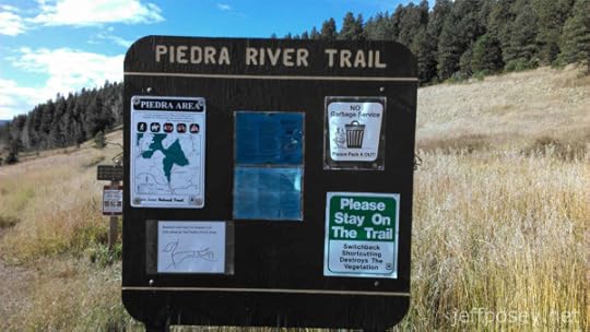
If you are ever in or around Pagosa Springs, Colorado, this is the best short day hiking trail around, according to me and my wife, Danielle.
Why? Short walk, a shade over two miles round trip (though you can go much farther if you want). Grade is easy. Trail is clear. And you cut through a wonderful little canyon.
Read more about it on TripAdvisor.
Meadow of Piedra River Trail
Your walk begins in a tilted meadow with the river (a big mountain stream, really) to the left.
A faint trail soon splits off to the right, up to some cracks in the rocks that have ice in them year-round. If you need more exercise, that’s not a bad side-trip.
Down the Canyon

This is your first good view looking down the canyon. The stream rushes, the sun is warm, and river otters are said to ply the waters (I’ve never laid eyes on one).
Cliff Across the Way

I like this photo. The cliffs across the Piedra River from the trail, before you get down into the depths of the canyon.
Always walk slowly and look around a lot. Seeing is high-quality living.
Canyon of the Piedra River
This is the big payoff view of the Piedra River Canyon.
It’s not the only payoff view. There are hundreds more. Heck, every step gives you a slight variation on yet another payoff view.
The first time we walked this, we both kept saying, “Wow.”
It’s easy to see why the big blocks fall, with the river eroding them from the base like this.
The last time we were there in the spring of 2015, the water was maybe three feet higher. That adds a lot of background noise, let me tell you.
Dark Cliff of the Piedra River

Not a good photo, I know. Bad lighting. But it’s the most massive cliff profile you see on this walk.
From the road, there’s a short trail from a pull off that leads to the top of this cliff, so you’ll sometimes see people up there looking down on you.
When I see human figures up there, I set up for a picture and call up to them, “Step a little closer!”
Sometimes they do.
“Just a little closer!”
When they bite and come closer, I switch to video hoping to catch some visual drama.
(Note: I’m kidding, I’m kidding. I’d never do such a thing. Especially with my wife around.)
Girls Looking for Pretty Stones

Below that dark looming cliff, there’s a wonderful little sitting area beside the river. When you look down at the beach and into the cold, clear shallow water, there are countless colorful pebbles and stones.
Danielle and Vicki began picking out their favorites and setting them out to dry.
Warning: Be prepared to carry out a few more pounds than you carried in. Little blue and reddish pebbles still hide in the nooks and crannies of our car and fanny packs. We’ll never get them all back out again. We always travel with the tiny souvenirs of the Piedra River Canyon.
Cliff over wife and friends

Cliffs on the way out with Danielle, Vicki, and Mike for scale.
Would you climb those cliffs?
Me either, but people do. Climbing pitons for tying off the ropes of climbers cover this and other cliff faces. You’ll often see climbers making their way up, a partner on belay below, and an inevitable nervous dog or two looking up at their insane masters.
Cliff over Mike

More towering cliff, with Mike for scale.
Cliff over Danielle and Vicki

A typical view walking out, with Danielle and Vicki for scale.
Big blocks of the canyon wall have fallen over time toward the riverbed, and the trail winds in and out of them. It’s a magical place.
Cliff over Jeff

Now it’s my turn. When I take pictures, I’m never in them. I have to rely on the cameras of others to get a glimpse of me. Thanks, Mike!
Big Tree

That’s one big tree that dwarfs Vicki and Danielle. Look how it’s growing from that boulder. So, the boulder obviously has not shifted in the what, hundred-plus years it’s taken for this tree to grow?
I’ve spent the equivalent of years in deep back-country wilderness. It’s my experience that, while most people think the wilderness is a “wild” and active place, most of the time, very little happens. Bounders fall and sit the way they landed for hundreds of years.
And then another boulder falls.
My father, a World War II B-17 Flying Fortress veteran, says flying, even in war, is boring most of the time because nothing happens but getting there or getting back. But then there are the long moments of sheer terror.
When this big boulder finally rolls, will this tree feel the terror?
Treasure Falls Trail
This is one of the shortest hikes in the area, on the main highway (160) about halfway between Pagosa Springs and Wolf Creek Pass.
But the payoff is a wonderful waterfall.
Treasure Falls Sign

Note the “no restrooms.” There used to be one here, but they took it out, I don’t know why. It’s also so heavily used, it’s hard to find a private place to do your business. So it’s best to start this walk with an empty bladder.
Treasure Falls

This is not at the Piedra River Canyon, which is west of Pagosa Springs.
This is Treasure Falls, just off Highway 160 between Pagosa and Wolf Creek Pass, which crosses the continental divide.
A couple of years ago I solo hiked up and over Treasure Mountain from near these falls in a soaking rain. People think I’m crazy. But I loved it.
At the top, wet and bedraggled, an eagle flew low over me clutching a small animal, mouse or vole or chipmunk, and careened into the trees. I moved sideways and kept my binoculars on the spot and finally found the mass of sticks that must have been the nest.
No one else in the world saw that. Just me.
Have I mentioned how much I love hiking in deep wilderness? Moments like these stay with me forever. I have thousands of them, so many I’ve forgotten most. But they come back to me when I need them.
Treasure Falls from Afar

It’s just plain pretty no matter how you look at it.
Pagosa Lodging
We’ve rented more than a dozen homes through VRBO (Vacation Rentals By Owner). This is our favorite.
The Lewis Street Treehouse

This is the most comfortable place we’ve stayed in and around Pagosa Springs. Find out more on the VRBO listing.
See my review here: Our Favorite Pagosa Springs Rental! Mine shows as “Anonymous” for some reason. It’s signed —Jeff & Danielle. So it’s not really anonymous at all. The VRBO system seems to think I want to hide my identity.
Rainbows
I’ve seen more rainbows in and around Pagosa Springs than anywhere else. They must have a good contract with whoever controls the weather.
Rainbow from the Treehouse

From the front deck of the Lewis Street Treehouse. It’s a double rainbow, though you can’t see the double in the photo.
So Long!
Goodbye from Danielle & Jeff

If you ever visit Pagosa Springs, Colorado, I hope you enjoy it as much as we do!
The post Pagosa 2015 Snapshots and Notes appeared first on Jeff Posey.
September 8, 2015
Why Did the Anasazi Collapse?
This is the single most enduring question about the Anasazi culture. Why did they abandon the Four Corners of the American Southwest by about A.D. 1300?
There are several competing and commingling theories about what drove (or attracted) them away. Drought, or climate change, is the most commonly believed cause of the Anasazi collapse. But recent ideas include extremist politics and religion, and an unsustainable stratification between the rich and poor—the ancient equivalent of income inequality that so infuriated the masses, they couldn’t take it anymore and left.
Climate change and drought is easy to understand. If your farmers can no longer grow enough food to feed your own people, and the drought lasts longer than the food stores you have set aside, then your culture collapses. The game is over. Those who can move, do. Those who can’t, perish.
Indeed, the Anasazi Great Drought of 1275 to 1300 is commonly cited as the last straw that broke the back of Anasazi farmers, leading to the abandonment of the Four Corners.
Extremist politics and religious zeal can be anything from external forces that invaded the Anasazi lands and took over like occupying Nazis, or internal strife over which priests to follow, erupting like a series of Mafia turf battles that became so intolerable everyone decides to escape.
The end of the Anasazi heyday was characterized by widespread violence, especially in the Chaco Canyon outliers, and social-control cannibalism, a subtle form of warfare and an outrageous form of political control, seemed to be a mechanism for the elites of Chaco Canyon to ensure the outlying farmers continued to supply them with food, even when times were tough.
But even this fails if the farmers can’t grow enough food to even sustain themselves.
Religious zeal, most interestingly, can also mean a high-powered belief system that sprang up somewhere else and attracted all the remaining Anasazi to a new holy land. The most likely candidate for this is the Kachina cult, which appeared around A.D. 1325, about a generation after the Anasazi disappeared from the Four Corners region.
But religion can also be highly political, and can be related to the religious-political power structure of an elite minority of governor-priests who hastened the Anasazi collapse with their policies and practices that failed to adapt to changing environmental and social conditions—such as the extreme building sprees that characterized Chaco Canyon in the generation or two preceding its collapse.
Most likely, it’s a complex combination of two or three (or more) of these simplistic causes. It’s easy to imagine an overbearing class of leaders who used cannibalism and violence to coerce the surrounding communities into providing food and laborers for their frenzied public works programs in Chaco Canyon, combined with climate change that reduced the surplus calories farmers could provide, creating a volatile cultural environment that would make a new and distant religion look very appealing as a way to salvation.
And finally, when a culture has more rich people to support than poor people to sustain them, then whole system collapses for everything. There is ample evidence of this as contributing to the Anasazi collapse.
The Anasazi culture is not the only one in human history to have collapsed, unfortunately, and the patterns are similar. Even today, we can see in our own American culture an upper class supported by increasingly extreme income inequality (the growing “surplus” productivity of average workers flows entirely to a tiny ultra-rich minority), a climate that is changing (exacerbated by our own actions), and a rise of religious fervor (marked by increasing rejection of science and rational thought).
This line of inquiry, research, and thinking led directly to my contemporary thriller, Price on Their Heads: A Novel of Income Inequality and Mayhem.
For now, let’s look at evidence for why the Anasazi collapsed. In subsequent Author Notes, we’ll examine how Anasazi wealth and productivity was distributed, and similarities of modern trends in income inequality with Anasazi inequality.
Drought, or climate change
The Anasazi were amazingly successful in a difficult environment for a very long time

Environmental problems, especially major droughts and episodes of streambed erosion, tend to recur at intervals much longer than a human lifetime or oral memory span. Given those severe difficulties, it’s impressive that Native Americans in the Southwest developed such complex farming societies as they did. Testimony to their success is that most of this area today supports a much sparser population growing their own food than it did in Anasazi times. —Collapse: How Societies Choose to Fail or Succeed, by Jared Diamond
The Anasazi flourished from A.D. 900 to 1300, which is nearly twice as long as the United States has been in existence. (And the Puebloans who descended from them, in much reduced numbers, have 700 years under their belt.)
So even though the Anasazi culture ultimately collapsed, it was extraordinarily successful for a very long time in a very difficult environment.
Will we last as long?
The U.S. Southwest is a marginal environment for agriculture at best

Favorite single-factor explanations [for the Anasazi collapse] invoke environmental damage, drought, or warfare and cannibalism. Actually, the field of U.S. southwestern prehistory is a graveyard for single-factor explanations. Multiple factors have operated, but they all go back to the fundamental problem that the U.S. Southwest is a fragile and marginal environment for agriculture. —Collapse: How Societies Choose to Fail or Succeed, by Jared Diamond
If farming were easy and productive in spite of drought, the Anasazi would likely not have collapsed, but would have remained in place in one political form or another until the arrival of the Spanish in Pueblo country in 1539.
Living and thriving in a precarious environment, especially in a complex culture, requires a system that can react efficiently to changing conditions. That means a hierarchical structure that is prescient, wise, and flexible, or a flat structure that rewards individual or small collectives of farmers for innovation and best practices.
The Anasazi had neither.
Chaco Canyon couldn’t grow enough food to support itself

It turns out that, already in the 9th century, corn was being imported [into Chaco Canyon] from the Chuska Mountains 50 miles to the west (also one of the two sources of roof beams), while a corncob from the last years of Pueblo Bonito in the 12th century came from the San Juan River system 60 miles to the north. —Collapse: How Societies Choose to Fail or Succeed, by Jared Diamond
Like every major city today, Chaco Canyon could not feed itself. As with other material goods, such as the nearly quarter-million building logs that had to be hand-carried from sixty miles away or more, they had to import food.
Even though there is evidence of canyon-floor farming and gardening that undoubtedly contributed (similar to the modern trend toward rooftop gardening in many major cities), most calories flowed in from outlying areas.
Imagine the distribution network: Long-distance carriers loaded with all the dried food they could bear must have endlessly plied the road network leading into and out of Chaco Canyon, much as trucks and trains and cargo airplanes endlessly supply the big cities of today.
Also imagine the stories those traders would tell as they traveled, stopping along the way to sit with elders and relate the news of the day. The walking bosses of long strings of burden-bearers would have been the newspapers of the day.
The early Anasazi cut down the forests of Chaco Canyon

When the pinyon and juniper trees were cut down, the nutrients in the litter underneath the trees were flushed out. Today, more than 800 years later, there is still no pinyon/juniper woodland growing anywhere near the packrat middens containing twigs of the woodland that had grown there before A.D. 1000. —Collapse: How Societies Choose to Fail or Succeed, by Jared Diamond
One of the worst things a culture can do to its own environment is cut down their forests. Trees, masses of them, change or modulate the climate, the transpiration of moisture, control erosion, and retain soil nutrients. They also supply building materials and fuel.
Easter Island, one of the most isolated islands in the Pacific Ocean, once had a lush forest that included the largest variety of palm tree in the world. The island supported a large population of Polynesians during the same time period as the Anasazi. But when Europeans arrived in the 1500s, they found a bare island without a single tree and a tiny, starving population.
What did that Easter Islander think when they cut down the last tree? Why did their leaders tell them to do that?
In Chaco Canyon, at least they weren’t confined to an island. Yet still, what did they think when they cut down the last trees in the canyon? That it would be easy to coerce people to carry firewood and building beams from fifty or sixty miles away? That it didn’t matter? That a local resource was meant to be used up with no regard for future consequences? That new ideas (technology) or the gods would save them?
Cultures that conserve their natural resources, as a rule, last far longer than cultures that use them up at increasing rates until the inevitable collapse. It seems an obvious rule of natural law, yet human leaders (both public and private) of cultures throughout history across the globe, over and over, trade short-term gain for the certainty of collapse.
And people tend to follow those leaders all the way to the cliff and then over it.
Upset populations become troublemakers

The last identified construction at Pueblo Bonito, dating from the decade after 1110, was from a wall of rooms enclosing the south side of the plaza, which had formerly been open to the outside. That suggests strife: people were evidently now visiting Pueblo Bonito not just to participate in its religious ceremonies and to receive orders, but also to make trouble. —Collapse: How Societies Choose to Fail or Succeed, by Jared Diamond
One of the incredible characteristics of our human species is that we will do everything we can to try and make things work. We are ingenious. We are clever. We are hard-working. Creative solutions abound when times get tough.
So when farmers could no longer grow enough surplus calories to support themselves and an unproductive elite, and some of those farmers gang together and attack the elite (which is as inevitable as ultimate collapse when environmentally dependent humans fail to be reasonably conservative), then the obvious thing to do is to build better defenses.
When defense budgets go up, when a culture fears external terrorism and invasion more than it fears the ludicrous demands and directives of its own leaders, when the liberties of citizens are reduced and the growing productivity of their labor no longer improves their own lives, then collapse is a near certainty.
Horrible drought plus too many people to feed spells doom

The final blow for Chacoans was a drought that tree rings show to have begun around A.D. 1130. There had been similar droughts previously, around A.D. 1090 and 1040, but the difference this time was that Chaco Canyon now held more people, more dependent on outlying settlements, and with no land left unoccupied. —Collapse: How Societies Choose to Fail or Succeed, by Jared Diamond
Here’s yet another allusion to what continues to be an elephant in the room, even among gritty, hard-edged authors and thinkers like Jared Diamond: A growing, high population is deadly to a culture.
When population grows to the limits of a region’s (or a planet’s) ability to feed that population, then any jolt to the ecosystem that reduces the region’s (or planet’s) caloric productivity, automatically results in catastrophic mass die-offs and cultural collapse.
Human ingenuity may delay the inevitable, but most often it exacerbates it. The Anasazi, for instance, learned how to efficiently grow corn and beans and squash in an arid environment, which made life so much better, the population increased until their ingenuity could no longer keep pace with the needs of the many.
It was an enormously uncomfortable situation for them toward the end. So difficult, violence spread like wildfire while the leaders manically ordered the erection of yet more and grander public works projects, and those who could got out, escaped to the defensive cliff dwellings of the Mesa Verde and canyonlands to the northwest, perhaps to protect them from the angry, desperate thugs who worked for the failing elite of Chaco.
The post-apocalyptic worlds depicted in so much modern novels, television shows, and movies can give us a sense of what the Anasazi faced. There may not have been zombies, but a Sun Priest who orders a rebellious village of farmers to be killed, cooked, and eaten isn’t much better.
Anasazi farmers finally went on strike

Probably the outlying settlements that had formerly supplied the Chaco political and religious centers with food lost faith in the Chacoan priests whose prayers for rain remained unanswered, and they refused to make more food deliveries. —Collapse: How Societies Choose to Fail or Succeed, by Jared Diamond
They finally got mad as hell and wouldn’t take it anymore. When the farmers stop supporting you, stop buying into your failed economics, stop delivering calories to you, then the game is over no matter how rich you are.
Ultimately, it was drought and human choices that doomed the Anasazi

[W]as Chaco Canyon abandoned because of human impact on the environment, or because of drought? The answer is: it was abandoned for both reasons. —Collapse: How Societies Choose to Fail or Succeed, by Jared Diamond
It should come as no surprise to sentient beings that natural environmental change combined with human choices that degrade that environment lead to collapse or extinction. Especially when combined with an oppressive leadership that always demands more—more corn, more beans, more squash, more labor to build temples, more turquoise, more meat, more skins, more everything—even in the face of impossible conditions brought by a wildly varying climate.
Yet we sentient beings seem to have a hard time learning that lesson. Even if we did, the choices we would have to make would be enormously difficult—population (birth) control, very careful and conservative farming practices, and a system to share the wealth of the land among all who labor to produce that wealth.
The Great Anasazi Drought of 1275 to 1300 wasn’t really all that bad

“Overall conditions were pretty darn bad in the 1200s,” said Timothy A. Kohler of Washington State University. “But they were not maybe all that worse than they were in the 900s, and yet some people hung on then.” Even in the worst of times, major waterways kept flowing. “The Provo River didn’t dry up,” said James Allison, an archaeologist at Brigham Young University. “The San Juan River didn’t dry up.” Soon after the abandonment, the drought lifted. “The tree-ring reconstructions show that at 1300 to 1340 it was exceedingly wet,” said Larry Benson, a paleoclimatologist with the Arid Regions Climate Project of the United States Geological Survey. “If they’d just hung in there…” Though the rains returned, the people never did. —“Vanished: A Pueblo Mystery,” by George Johnson, April 8, 2008, The New York Times
So if the drought wasn’t that bad, why couldn’t they hang on? Why couldn’t they just stop having babies for a while, let the old and sick people die, maybe kill off the most offensive of their arrogant elite, and re-form themselves?
They had likely done something like that before. Most human revolutions involve those kinds of actions.
Something, this time, was markedly different. Perhaps the population was simply too big, and the die-offs were so psychologically intolerable, they couldn’t take it anymore. If you live in Manhattan and two-thirds of the population died, and none of the city services worked anymore, would you stick around? Probably not.
New technology and science only makes things worse

Science will surely save us, the nay-sayers may yell. But technology, argues Motesharrei, has only damned us further. Technological change can raise the efficiency of resource use, but it also tends to raise both per capita resource consumption and the scale of resource extraction, so that, absent policy effects, the increases in consumption often compensate for the increased efficiency of resource use. In other words, the benefits of technology are outweighed by how much the gains reinforce the existing, over-burdened system — making collapse even more likely. —“NASA Study Concludes When Civilization Will End, And It’s Not Looking Good for Us,” by Tom McKay, March 18, 2014, News.Mic, derived from a report written by applied mathematician Safa Motesharrei of the National Socio-Environmental Synthesis Center along with a team of natural and social scientists
It’s fashionable and tempting to think our ingenious minds, and the technology we’re so proud of, will save us.
We’ll find new sources of energy, create more productive crops, find ways to grow food in formerly barren places, even build spaceships to move to distant uninhabited planets where we can start over.
But every time we’ve improved technology in the past in ways that allows a population to live more comfortably, we reproduce past the point of comfort. It’s our reproductive imperative as much as it is for rates or even bacteria. It’s in our DNA. We can’t seem to help it.
At best, technology can only delay the inevitable, while making the outcomes of that inevitability worse for everyone.
I can’t tell you how much this depresses me. I want to believe in humanity, that we will overcome all adversity, that we can continue to build a world that is just and fair and comfortable for everyone in it.
But the evidence of human history is completely counter to that belief.
Perhaps that’s why we turn to religion. Because we really, really need a miracle.
Politics and Religion
How would tree rings and archaeology account for the Mormon migration to Utah in the 1850s?
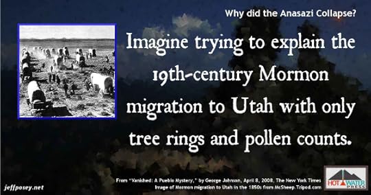
Ultimately the motivation for the abandonments may lie beyond fossils and artifacts, in the realm of ideology. Imagine trying to explain the 19th-century Mormon migration to Utah with only tree rings and pollen counts. —“Vanished: A Pueblo Mystery,” by George Johnson, April 8, 2008, The New York Times
I love this idea! If we used purely archaeological evidence for the recent history we know so well, how wrong would we get it?
Very wrong, mostly likely.
Therefore what we think we know about the Anasazi, we really don’t. And anything we can imagine about them may be as correct as what the “facts” encourage us to believe.
We just don’t know. And we never truly will.
Religious and political ferment may have brought the Anasazi down

Scientists once thought the answer lay in impersonal factors like the onset of a great drought or a little ice age. But as evidence accumulates, those explanations have come to seem too pat — and slavishly deterministic…. Looking beyond climate change, some archaeologists are studying the effects of warfare and the increasing complexity of Anasazi society.… “The late 1200s was a time of substantial social, political and religious ferment and experimentation,” said William D. Lipe, an archaeologist at Washington State University. “You can’t have a situation where it just happens that hundreds of local communities for their own individual, particularistic reasons decide to either die or get up and move,” Dr. Lipe said. “There had to be something general going on.” —“Vanished: A Pueblo Mystery,” by George Johnson, April 8, 2008, The New York Times
When the end is nigh, people turn to religion more than to political and economic institutions. When you’re one step away from just giving up, laying down your burdens and breathing your last breath, a messiah with a clarion message can rejuvenate you, urge you to do superhuman things.
Perhaps in the Anasazi world, such a call went across the land as their world was falling apart. Perhaps they heeded it and joined the masked men imitating spirits that had long been asleep that urged them to chant and dance and to get along with each other without paying tribute to their lunatic leaders.
Why not? They had nothing to lose.
Kivas, and perhaps religion, became more open to everyone in the 1200s

By studying changes in ceremonial architecture and pottery styles, Donna Glowacki, an archaeologist at the University of Notre Dame, is charting the rise of what may have been a new puebloan religion. For more than a century, the established faith was distinguished by multistory “great houses,” with small interior kivas, and by much larger “great kivas” — round, mostly subterranean and covered with a sturdy roof. Originating at Chaco Canyon in northwest New Mexico, the formidable temples seem designed to limit access to all but a priestly few. Though Chaco declined as a regional religious center during the early 1100s, the same architecture spread to the Mesa Verde area. But by the mid 1200s, a different style was also taking hold, with plazas and kivas that were uncovered like amphitheaters — hints, perhaps, of a new openness. —“Vanished: A Pueblo Mystery,” by George Johnson, April 8, 2008, The New York Times
The descendants of the Anasazi, the modern Puebloans, are a strictly egalitarian society. I’ve heard stories that when a Hopi man gets a new pickup truck, his neighbors ostracize him until it becomes a beat-up old truck like everyone else’s.
Their obsessively flat culture may be a reaction to the overly stratified culture of the Anasazi that failed.
The Anasazi lasted about 400 years. The modern Puebloan cultural form has lasted more than 700 years.
They may be onto something.
Perhaps the Anasazi went through a religious reformation that called for migration

If the pueblo people had left a written history perhaps we would read of the Anasazi equivalent of the Protestant reformation. —“Vanished: A Pueblo Mystery,” by George Johnson, April 8, 2008, The New York Times
It’s not uncommon in human history for such things as the Protestant reformation to happen—out with the old, in with the new. We do that all the time when we can. If we can’t overturn the king, then we overturn the Pope. If we can’t do that, then we kick the scoundrels out of Congress. If we can’t do that, then we go have a beer and wait for the impending collapse.
The Anasazi didn’t have beer. Insofar as we know.
The Kachina religion may have been the draw for the Anasazi migration

Other archaeologists see evidence of an evangelical-like religion — the forerunner, perhaps, of the masked Kachina rituals, which still survive on the Hopi and Zuni reservations — appearing in the south and attracting the rebellious northerners. Salado polychrome pottery may have been emblematic of another, possibly overlapping cult. —“Vanished: A Pueblo Mystery,” by George Johnson, April 8, 2008, The New York Times
The Hopi and Zuni people who practice the Kachina religion are extremely closed-mouthed about it. So we don’t really know what it entails, other than spirits that spend most of the year hiding, and part of the year coming out into the streets and playing pranks on people.
What we do know about it is that there is no High Priest, no Pope, no CEO of the not-for-profit organization that supports it, no professional lobbyists in Washington, D.C., that work to curry political favors, no threat of mass cannibalism if dirt-poor farmers don’t give the Kachinas all their surplus food.
So whatever it is, exactly, is far, far better than what the Anasazi had. And maybe what we and other modern cultures have.
Economic Stratification
Chaco Canyon elites consumed an enormous amount, but produced very little

Chaco Canyon became a black hole into which goods were imported but from which nothing tangible was exported. —Collapse: How Societies Choose to Fail or Succeed, by Jared Diamond
This is arguable in some relatively minor ways. Chacoan-worked turquoise beads were widely traded, though not in enough quantity to have made them a major trading force.
From a big picture perspective, Chaco Canyon was indeed a black hole of calories (expressed as food and as labor), which soaked up all of the surplus productivity of the land and the farmers who worked the land.
What did the Chacoan elites give in return?
At best, they centrally stored and redistributed (in short-term hard times) surplus calories in the form of dried beans and corn and squash.
They also provided unifying ritual and culture, a way to imbue meaning into what must have been a hardscrabble, gritty, uncomfortable existence for all but the elites living in the big houses.
That unifying force held a widely scattered, highly diversified culture together for a very long time, so its importance cannot be overstated. Whatever it was exactly we may never know. But it worked. Until it didn’t.
Anasazi chiefs ate better than the peasants

As for evidence that the chiefs ate better than did the peasants, garbage excavated near Great Houses contained a higher proportion of deer and antelope bones than did garbage from homesteads, with the result that human burials indicate taller, better-nourished, less anemic people and lower infant mortality at Great Houses. —Collapse: How Societies Choose to Fail or Succeed, by Jared Diamond
Of course they did. Any culture in which the leaders used the threat of cannibalism to force common farmers to accept high taxation of their harvests would exhibit a highly lopsided quality of life. And besides, human meat is highly nutritious, so I’ve heard.
Would the farmers be resentful? Watching the healthy children of the arrogant elites thrive while their own children cried themselves to sleep with empty bellies when their own meager stores ran out, how could they not?
But the threat of violence would keep them in line as long as the High Priests and their entourage made good on the threats and as long as the rains came in response to their ceremonies and entreaties to the gods.
When anything went wrong, though, when any crack appeared in the façade of the elites, when the rains didn’t come and the crops failed…what then? How long would a farming family stay and take it? What could entice them to move?
From our modern perspective, it’s easy to think we wouldn’t take it. We would fight back or at least leave. As my wife says, “We would be the first ones out of that place.”
The elders would urge caution and patience, while the hot-blooded young men would let off steam by going on long hunting trips or laboring in the fields, perhaps even marauding nearby farmers and clans. They might have wanted to form a force to reckon with the overbearing elites, but if their farms were too scattered, if the clans were too inwardly focused and distrustful of other clans, then all they would only be able to glare at the High Priest Kings and their Princes as they strutted around in the big houses the farmers’ forefathers had been forced to build.
The buck stops here: The rich upper-class caused the Anasazi collapse

Motesharrei’s report says that all societal collapses over the past 5,000 years have involved both “the stretching of resources due to the strain placed on the ecological carrying capacity” and “the economic stratification of society into Elites [rich] and Masses (or “Commoners”) [poor].” This “Elite” population restricts the flow of resources accessible to the “Masses”, accumulating a surplus for themselves that is high enough to strain natural resources. Eventually this situation will inevitably result in the destruction of society. —“NASA Study Concludes When Civilization Will End, And It’s Not Looking Good for Us,” by Tom McKay, March 18, 2014, News.Mic, derived from a report written by applied mathematician Safa Motesharrei of the National Socio-Environmental Synthesis Center along with a team of natural and social scientists
This, from a completely different perspective, is what modern macroeconomists argue when they decry the trends of income inequality in the U.S. and other developed countries.
If the additional wealth from increased productivity of a worker is not shared with that worker, then what’s the point in working harder and being more productive? Over the long haul, it leads to apathetic workers, an over-reliance on welfare, and a growing resentment of the increasingly disconnected upper class.
That’s exactly what my contemporary thriller, Price on Their Heads: A Novel of Income Inequality and Mayhem, is about, directly inspired by my research into the Anasazi and other cultures that collapse.
Without the “have nots,” the “haves” cannot survive

In a stratified society there can be no cooperation between the “haves” and the “have nots” if the daily needs of the humble producers are not sustained. —Anasazi America: Seventeen Centuries on the Road from Center Place, by David E. Stuart
And without cooperation between the social layers, the whole social contract will collapse.
It’s as inevitable as a corn seed failing to sprout when the soil has no moisture.
Conclusion
This is a very bare sampling of everything I could have included here. In fact, from time to time I will add to these sources. I’m constantly finding new and interesting tidbits that fit neatly into what is becoming an increasingly clear picture of what leads to the collapse of cultures.
After researching the Anasazi and other cultures that collapse, what do we see in our modern world that are telltale signs of impending collapse?
There are many, unfortunately. Environmental degradation, particularly of our farming soils and the health of our forests. Increasing religious fervor with an attendant rejection of science and reason. And income inequality trends that are arguably the worst in U.S. history.
Next week we’ll look at Anasazi wealth distribution and how it’s similar to today’s, and the week after, we’ll take a deeper dive into modern income inequality.
Meanwhile, here’s more on my novel, Price on Their Heads: A Novel of Income Inequality and Mayhem.
This is background research for
 Price on Their Heads: A Novel of Income Inequality and Mayhem, out in paperback, ebook coming soon!
Warning! This story contains impolite language, graphic violence, a little sex, and is very politically incorrect.
Jackie Key inherits a full scholarship from a rich man murdered by his brother. To justify his complicity, he studies the economic ripple effect of the dead man’s assets.
What he discovers and tries to publish makes him become public enemy number one among the country’s rich and powerful because Dr. Jackie Key can calculate a true price on their heads.
From Jeff Posey, author of The G.O.D. Journal, comes a twisting and turning contemporary political thriller that exposes the cruelly tilted playing field of American economics and politics.
Join Nobel Prize-winning economist Dr. Jackie Key as the heavy-handed government and ultra-rich drive him into the grasp of his brother, head of a team of assassins targeting Jackie’s list of the “too rich to exist.”
Jeff Posey writes novels inspired by the Anasazi culture of the American Southwest a thousand years ago.
“Cultures that have dramatically collapsed,” he says, “should at least compel us to dream up stories about how such things can happen.”
He does not, under any circumstances, advocate violence against anyone, even the too rich to exist.
Jeff’s Books on Hot Water Press
Image Credits
—Tiny Anasazi corncobs in the hand from Waymarking.com.
—Image of piñon tree clinging to a cliff from New Mexico Piñon Coffe at nmpinoncoffee.com.
—Image of the Grinch as troublemaker from Sodahead.com.
—Image of farmers striking from Our Flat World.
—Image of the Great Awakening in the U.S. Colonies from AllWeightLossInfo.net (yeah, surprised me, too).
—Image of people tubing the San Juan River through downtown Pagosa Springs, Colorado, is from TripAdvisor.com.
—Image of Mormon migration to Utah in the 1850s from McSheep.Tripod.com.
—Image of open kiva at Chimney Rock National Monument by Jeff Posey.
—Image of Martin Luther nailing his Ninety-Five Theses to the door of All Saints’ Church in Wittenberg on 31 October 1517 from Augustine1 Conservative Christian Worldview Blog.
—Image of Kachina dolls from AnimationResources.org.
—Image of rich guy lighting a cigar with money from IvyVest.com.
—Image of science saving us all from LiamScheff.Com.
The post Why Did the Anasazi Collapse? appeared first on Jeff Posey.
August 11, 2015
Were the Anasazi Nazis?
Not actual Nazis. That’s absurd. But how much were they like Nazis? Were they authoritarian? Violent? A force that invaded from the outside and subjugated the indigenous people using threats of atrocities?
Asking this question demands a shift in the meaning of “Anasazi.” Just because the Nazis occupied France until 1944 did not make French people Nazis.
Perhaps the Four Corners natives forced to grow food, erect great stone buildings, and serve the occupiers were victims of the Anasazi, but not Anasazi themselves.
What known characteristics of the Anasazi have a whiff of Nazi to them?
Quite a lot.
The Anasazi ruled by Nazi-like terror
Until recently, archaeologists saw Chaco as an orderly, peaceful civilization dominated by astronomer-priests, tradesmen, and governors…. In a fashion perhaps comparable to the gory Aztec rites witnessed by Cortés [he conquered Aztec Mexico in 1519], Chaco rulers may have intimidated potentially rebellious chiefs by forcing them to look on as they sacrificed and cannibalized chosen victims. Terror may have been the glue that held the Chaco culture together. —Roberts/Old Ones p. 161
This is hard to take for some people. Modern Puebloans are so egalitarian and nonviolent, we want to project that back to their Anasazi roots.
But it may very well be that modern Puebloans are so egalitarian and nonviolent as an opposing reaction to the hyper-violent world of the Anasazi.
Like Nazis, invading and occupying Anasazi may have conquered the scattered (but increasingly productive) farmers in the region by threatening them with unspeakable things. Not concentration camps for oppressed clans and religions, but violence against entire villages and families so extreme and sudden that no one could resist.
Sounds like Anasazi Nazis to me.
Puebloan oral histories contain stories of state-sponsored religious violence

Despite [the] secretiveness [of modern Puebloans], ethnographers over the years have uncovered plenty of evidence that warfare and violence played a central role in Pueblo life. [The] governor of Zuni…told John Gregory Bourke in 1881: “In the days of long ago all the Pueblos…had the religion of human sacrifice at the time of the Feast of Fire, when the days are shortest. The victim had his throat cut and his breast opened, and his heart taken out by one of the [priests]; this was their religion, their method of asking good fortune.” —Roberts/Old Ones p. 156
While the Nazis worshipped the altar of the war machine, Puebloans even after the fall of the Anasazi tortured and killed victims on the altars of their gods.
The class of Nazis who controlled the war machine became overlords of their own people and the people they conquered and tried to eliminate. The class of Anasazi who controlled the priests who chose and murdered the sacrificial victims became overlords of the bureaucracy that supported them and the scattered farmers who fed them.
Again, this points to something like Anasazi Nazis.
Villagers tried to defend themselves from Anasazi Nazis

“Around 1250,” [says Bruce Bradley of the Crow Canyon Archaeological Center], “you see an incredible change. Everybody’s moving into the canons, building cliff dwellings. At Sand Canyon, seventy-five percent of the community lived within a defensive wall that surrounded the pueblo. All through southeastern Utah, northeastern Arizona, southwestern Colorado, the same thing’s happening. Suddenly, at 1250, the trade ware goes to zero. Before that, you had plenty of far-traded pottery, turquoise, shells, jewelry.” —Roberts/Old Ones p. 150
Who were they defending themselves against?
Just as every country that faced invasion and attack from the Third Reich hastily constructed defenses, people of the Four Corners tried, ultimately unsuccessfully, to defend themselves against the violence of the Anasazi.
Most construction in the canyon itself stopped between 1116 and 1120, and some older great houses such as Chetro Ketl were actually being abandoned. But at others, as at Pueblo Bonito, new walls and room blocks were built to close off old courtyards and limit access. More tower kivas, such as El Faro on the Great North Road, were built and appear to have been used as watchtowers…. —Stuart/Anasazi America p. 121
This can cut two ways. The good guys could have been in the Chaco Canyon center, and the bad guys are invading.
Or the bad guys are in the canyon center, and they think someone is going to invade.
More likely, some Anasazi Nazi “general” got too big for his britches and decided he could kick over the boss. Like a big generations-long mafia war, turf changing all the time, with giant leftover stone buildings that drive the rest of us crazy trying to figure out.

Large religious gatherings did not take place in Chaco Canyon after 1100. —Stuart/Anasazi America p. 143
Did their gods desert them? Or did the people simply stop coming? They had enough and just walked away. Sometimes, looking at the sites and the evidence, that’s what it feels like happened. They walked away because they wouldn’t take the murderous rants of the High Priest anymore.
How many people wish the populace of Germany had done that to Hitler?
The rise and fall of the Second Reich in ancient Mexico: Toltecs, pre-Anasazi Nazis
Toltecs…have been implicated for Chaco, and that timing works. There may indeed be historical connections—but probably not…direct string pulling. If Toltec notions reached the Southwest, they probably came indirectly. —Lekson p. 113
A radical splinter group could have broken away from the collapsing Toltecs (in Mexico) and made their way north to try and build a new and improved Toltec world.
The Toltecs were some of the most violent people on Earth at the time, sacrificing long lines of the lower class in the name of appeasing their celestial gods. They began to collapse in the 900s, and finally flamed out in 1170.
That’s why Lekson says the timing works. The meteoric rise of the Anasazi comes during the Toltec nation’s death throes.
The flamboyant political adventures of the Anasazi Nazi movement
The events of 1150 to 1300 [spelled] the end of Tula [Toltecs] and consequent regional reorganization marked by audacious long-distance trade and flamboyant political adventures. —Lekson p. 144
This is tantalizing more than education. What audacious and flamboyant political adventures?
I can certainly imagine. That’s what I do. But before I spin off into fantastical daydreams, I like to know what people who study the Anasazi for a living think. And all we know here is that audacious, flamboyant things happened. Which, taken with nothing more, definitely has a Nazi flare to it.
I take this to mean a couple of things. First, leaders of the early Anasazi modeled themselves on the Toltec city-states to the south, which included the equivalent of kings who retained power by sacrificing members of the lower class to their gods. Second, splinter groups from the collapsing Toltecs made audacious and flamboyant forays into the Four Corners and tried to recreate the glory of what they had back home.
The Anasazi Nazis had a central government supported by the use of force

Chaco…had a central government, however diffuse or non-Western…. It’s likely that Chaco had a regional economy. And perhaps Chaco and its successor, Aztec Ruins [in northern New Mexico], had the use of force; witness the brutal by apparently socially sanctioned events of the twelfth and thirteenth centuries. —Lekson p. 223
Oppression takes many forms, from religious persecution to slavery to mass murder to state-sponsored terrorism. Most require the use of physical force directed by a centralized leadership.
The exception may be religion. All kinds of human atrocities have been justified and carried out in the name of God or gods.
The Nazis preferred the disproportionate use of force to the coercive powers of religion. The Anasazi Nazis likely used both.
The Rise and Fall of the First Reich in Ancient Mexico: Teotihuacán, pre-Toltec Anasazi Nazi roots
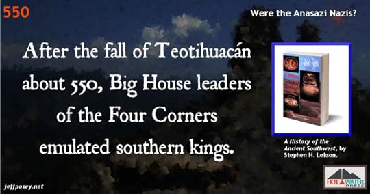
The fall of Teotihuacán [thirty miles northeast of modern-day Mexico City] (about 550) sent tsunamis of political power outward, rulers looking for places to rule. In the following decades, displaced, dispersing elites transformed cities and towns throughout Mesoamerica.…Petty chiefs and Big House leaders [of the Four Corners]…were tempted to emulate southern kings. —Lekson p. 231
Prior to the rise and fall of the Second Reich of the Toltecs was the stratified and violent Teotihuacán culture.
The first seeds of an oppressive and centralized government in the Anasazi Nazi capital of Chaco Canyon may have come from splinter groups from the fall of Teotihuacán.
The native farmers of the Four Corners may have suffered wave after wave of carpetbaggers from the South who kept trying to remake them into an echo of the glories of the homeland.
The Anasazi Nazis built a stable society—for a time
Many things came to Chaco and stayed there, in the service of the kings. Maize moved into and through the canyon, from places that had plenty to places that had none. Consequently, violence and raiding almost ceased. Its success, from 900 to 1000, allowed Chaco’s leaders to expand their horizons. Its influence soon reached far beyond its original domain…. Local leaders almost everywhere on the Plateau joined with or deferred to Chaco…. From 900 to 1200, Chaco kept the peace, promoted the general welfare, enhanced its own glory, and got things done. —Lekson p. 235
Before the German Nazis invaded Poland in 1939, Nazi Germany thrived in spite of global economic recession.
The Anasazi created the Great North Road. The Nazis created the German Autobahn

In the midst of the Great Depression, the Nazis restored economic stability and ended mass unemployment using heavy military spending and a mixed economy. Extensive public works were undertaken, including the construction of Autobahns (high speed highways). The return to economic stability boosted the regime’s popularity. —Wikipedia/Nazi
Before totalitarianism reaches the tipping point of the maniacal quest for global domination, it can reduce chaos and bring stability, which can make it look pretty good to the soon-to-be-violently-subjugated populace.
But when the fall comes, as it must, it is a long, hard ride for everyone.
All of this evidence of violence dates to the 1100s. —Stuart/Anasazi America p. 121

The two centuries following the decline of the Chacoan society were the most violent and tragic in the Southwest’s entire human history up to that time. —Stuart/Anasazi America p. 142
That’s when the hard ride down started for the Anasazi Nazis: the 1100s.
Mass executions by the Anasazi Nazis
To enforce its failing rule, Aztec [the Anasazi site in northern New Mexico unrelated to the true Aztecs—it’s a really bad name for the place] unleashed lethal force. At farmsteads, squads of warriors fell upon families failing in their duties, old and young. They were executed to intimidate other villages that might be thinking of slipping Aztec’s yoke. Men, women, and children were brutally and publicly killed and left to rot, unburied, in the ruins of their homes. These horrible scenes replayed a score or more times, but even terror could not hold Aztec’s failing polity together. —Lekson p. 239
As a totalitarian regime tries to expand its grip—or retain it in the face of opposition and crumbling fortunes—it tends to line people up and kill them.
Most of the 11 million victims of the Holocaust were killed after the United States entered the war against Hitler’s Nazis. (Source: Holocaust Timeline on HistoryPlace.com)
Was there an Anasazi Nazi Hitler Youth Organization?

Young people brought up in Aztec’s reign of terror were perhaps inured to and inclined toward violence. —Lekson p. 240
The Hitler Youth, the organization of the Nazi Party before and during World War II to enlist boys aged fourteen to eighteen into paramilitary service and indoctrinate them into Nazi philosophy. They contributed heavily to the ranks of the Nazi military and military police, organizations inclined in the extreme toward violence.
As Lekson says, similar things must have happened in the reign of the Anasazi, as in all such disproportionately powerful human organizations.
The fall of the Toltecs energized the rise of the Anasazi Nazis

Tula [Toltecs] fell about 1150. [W]ith Tula’s end, the Post-Classic pattern came into focus in vibrant clarity: expansive politics, long-distance dynamics, power plays and upheavals, and a swirling world of migrations, invasions, expulsions, and fragmentation. —Lekson p. 242
Since the beginning of the Chaco culture of Anasazis, the leaders were highly aware of the advanced city-state culture of the Toltecs to the south in Mexico. They emulated them in more than Chacoan architecture. The entire Chaco culture was a long-distance mirror of the Toltecs.
So when the Toltec structure began to crumble and fall, it must have sent the Anasazi leaders into a frenzy of worry.
Just as when Poland fell so easily to the Nazis in 1939, it spread shockwaves throughout Europe that preceded all-out war.
Were there Anasazi Nazi warriors?

No evidence of a large, armed warrior class has been found. The “warrior” burials at Pueblo Bonito…date roughly to A.D. 1100. —Stuart/Anasazi America p. 118
Now this is curious. There was plenty of evidence of the Nazi armies.
If the Anasazi were as aggressively militaristic as the Nazis, where were the warriors?
It’s important to remember that the absence of evidence for something in no way rules it out.
But wouldn’t masses of Anasazi warriors have left some archaeological evidence?
Maybe not. Maybe they were dispersed in small groups or patrols throughout the Anasazi empire. Maybe they trained masses of new recruits far away in a place archaeologists haven’t discovered or recognized yet. Maybe the warrior class was only part time, like rural volunteer fire departments. In a thousand years, will there be archaeological evidence for volunteer fire departments?
The violence was so widespread, there must have been a force directing or causing that violence. That’s the evidence for a warrior class. The fact that they left behind evidence of victims.
The Anasazi as Tito’s Yugoslavia

As Chacoan society blossomed in the A.D. 900s and early 1000s, it probably incorporate several once-isolated tribal groups speaking different languages…. As Chacoan society came undone, those ancient linguistic, social, and religious differences would have been rich fodder for ethnic and tribal hatreds acted out in the uplands…[just as] Yugoslavia in the mid-1990s threw off…Tito’s nation and returned to medieval society. —Stuart/Anasazi America p. 143
Josip Broz Tito, the chief architect of Yugoslavia organized as a socialist federation. He was regarded as a benevolent dictator. He wasn’t a Nazi, but he did exert iron-fisted control over the many cultural groups that comprised Yugoslavia, which collapsed into civil and racial war in the early 1990s.
Imagine if, rather than exterminated Jews and Christians and other groups, Hitler had successfully coerced them all to live together under the Nazi regime. That’s the kind of boiling cauldron of emotions and tensions Tito kept under lid—until it blew.
The Anasazi would have faced very similar circumstances.
The source of Anasazi Nazi violence: blame the Toltecs

[D]uring this protracted period of Toltec cultural strife, between roughly A.D. 800 and 1000, waves of diverse Mexican traits were carried into the American Southwest by cultists, priests, warriors, pilgrims, traders, miners, farmers, and others fleeing or displaced by the widespread unrest and civil war in central Mexico. —Turner/Man Corn p. 463
From a new source, physical anthropologist Christy G. Turner III, we have corollary evidence and interpretation of evidence that the wave of Anasazi Nazis that invaded the Four Corners came from the collapsing Toltec nation centered near present-day Mexico City.
The ancient bones Turner examines tell a story of extreme violence that would have been a Four Corners Holocaust a thousand years ago.
Violence as social control: a Hitler method

We propose that in the Chaco area, some such group of Mexican [immigrants] was able to use these practices for social control, terrorizing the local populace into submission and developing the hierarchical social system we see reflected in the region’s architecture. —Turner/Man Corn p. 463
The architecture certainly does tell a story of extreme social stratification, centralized authority, and Toltec influence from the south.
If Hitler had more time before he over-reached with his war machine, he may well have built enormous grotesque structures that would stand today as testament to authority and hierarchy gone wrong.
The “intrusive terrorism” of the Anasazi Nazis

[T]he Chaco phenomenon suggests something that might be called “intrusive terrorism”: enter a place uninvited, often by force, and coerce by use of systematic violence and intimidation. —Turner/Man Corn p. 482
This essentially describes the Nazi invasion and occupation of Poland and France and other places before and during World War II.
Tactics change. But the strategy of the extreme use of violent force is perennial among humans.
How did the Anasazi Nazis remake the Four Corners?

We propose that these southerners [from Mexico, mainly the Toltecs]…entered the San Juan basin around A.D. 900 and found a suspicious but pliant population whom they terrorized into reproducing the theocratic lifestyle they had previously known in Mesoamerica. This involved heavy payments of tribute, constructing the Chaco system of great houses and roads, and providing victims for ceremonial sacrifice. The Mexicans achieved their objectives through the use of warfare, violent example, and terrifying cult ceremonies that included human sacrifice and cannibalism. —Turner/Man Corn pp. 482-483
There’s that “c-word,” cannibalism, again. It keeps cropping up in any deep inquiry into the Anasazi.
The Nazis didn’t eat their victims, insofar as I know.
But the Anasazi did.
Maybe the Anasazi were worse than Nazis. If, that is, there’s a moral scale that can be applied to terrorism, mass murder, ceremonial human sacrifice, and cannibalism.
Anasazi Nazi swastika: it’s mere coincidence

Far older than Germany’s Nazi regime, this [swastika-motif] icon of the Anasazi (or ancestral Hopi) had been considered sacred rather than malevolent. Specifically, it represented the center of Hopi land. —David/Hopi Swastika
The swastika is such a basic symbol, I believe if you give a hundred kids crayons and wait long enough, all one hundred will eventually draw a swastika.
And if there’s one who doesn’t? We should probably elevate them to High Priest.
Conclusion
The Anasazi-Nazi match is not perfect by any means. But the similarities are, from what I see, undeniable.
This is a difficult topic. We don’t want to think of any nature-loving Native American culture as being anything like the modern evil Nazis.
But they were.
This is background research for
 The Next Skywatcher: Prequel to The Last Skywatcher Triple Trilogy Series, out in paperback, ebook coming soon!
Warning! This story contains graphic violence including cannibalism.
“I really enjoyed it. It was well-written.” —Thomas Windes, thirty-seven-year veteran Anasazi archaeologist with the National Park Service.
Raised by his beloved Sky Chief grandfather and a mysterious albino woman, Tuwa expects to become the next skywatcher.
When a strange star appears in the sky, so bright it shines during the day, the High Priest, backed by ultraviolent warriors from the South, demands blood sacrifice.
Tuwa’s grandfather, a vocal opponent of the foreigners, is murdered in a public ceremony, cooked, and served to the stunned crowd. Next in line are Tuwa’s adopted mother and the girl he loves, Chumana.
Unable to watch, Tuwa flees in a blind panic into dark wilderness where he’s rescued by a long-distance trader who collects orphans to protect him and carry his goods.
Three years later, Tuwa returns with his hardened band of orphans intent upon revenge—only to discover that the stakes are much higher than he had imagined.
Mere revenge may not be enough.
Jeff Posey writes novels inspired by the Anasazi culture of the American Southwest a thousand years ago.
“Cultures that have dramatically collapsed,” he says, “should at least compel us to dream up stories about how such things can happen.”
He does not, under any circumstances, advocate cannibalism.
Jeff’s Books on Hot Water Press
Sources
—Roberts/Old Ones. In Search of the Old Ones, by David Roberts.
—Stuart/Anasazi America. Anasazi America: Seventeen Centuries on the Road from Center Place, by David E. Stuart
—Lekson. A History of the Ancient Southwest, by Stephen H. Lekson
—Turner/Man Corn. Man Corn: Cannibalism and Violence in the Prehistoric American Southwest, by Christy G. Turner II
—Wikipedia/Nazi. Nazi Germany article on Wikipedia
—Holocaust Timeline on HistoryPlace.com
—David/Hopi Swastika. “The Four Arms of Destiny: Swastikas in the Hopi World & Beyond,” by Gary A. David on TheOrionZone.com.
Image Credit
Swastika motif at Anasazi dwelling: Steven Pinker’s Photos on StevePinker.com
Autobahn photo: From “‘Autobahn sniper’ sentenced to more than 10 years in prison,” on TheGuardian.com, at http://static.guim.co.uk/sys-images/Guardian/Pix/pictures/2014/10/30/1414671113237/An-autobahn-near-Frankfur-011.jpg
The post Were the Anasazi Nazis? appeared first on Jeff Posey.
July 24, 2015
Where Did the Anasazi Come From?
When you first see an abandoned Anasazi ruin, you ask, “Where did they all go?” But then you begin to wonder where they came from in the first place. Did outsiders arrive, invaders from another culture, and subdue the locals? Or were the Anasazi homegrown?
It’s a simple question, but I warn you that it is entirely without simple answer.
Where did the Anasazi come from? Could they have been homegrown?

The period from A.D. 700-1130 saw a rapid increase in population due to consistent and regular rainfall patterns. Studies of skeletal remains show that this growth was due to increased fertility rather than decreased mortality. However, this tenfold increase in population over the course of a few generations could not be achieved by increased birthrate alone; likely it also involved migrations of peoples from surrounding areas. Innovations such as pottery, food storage, and agriculture enabled this rapid growth. Over several decades, the Ancestral Puebloan culture spread across the landscape. —Wikipedia
If the birthrate can’t supply the people, then we can’t call it homegrown. That’s pretty straight up.
But it doesn’t explain why people would move into an area and start making babies. Was it just small farmer families taking advantage of a decades-long wet period of easy times growing a bumper crop of corn and beans and greens?
Okay. That’s pretty straight up too. I can imagine that happening.
But why would they spontaneously construct the largest apartment-style buildings in the world? And build long, straight roads to nowhere?
They wouldn’t, without a very powerful reason.
Where Did the Anasazi Come From? Not from the loins of mothers born and raised in the Four Corners.
What exactly do we mean when we say “Anasazi” anyway?

There never was an “Anasazi tribe”, nor did anyone ever call themselves by that name. Anasazi is originally a Navajo word that archaeologists applied to people who farmed the Four Corners before 1300 AD. —BLM
Well, that solves all our problems right there! By definition, if they farmed anywhere in the Four Corners region before 1300, they were Anasazi—no matter if they were born there or moved in. Until they started farming, the Anasazi didn’t even exist.
It’s like saying all the land rushers in Oklahoma when it opened for non-native settlement didn’t exist until the first land rush happened. Anasazi is a description of behavior, not cultural origin.
But it’s kind of a chicken way out. Did local non-farmers become farmers (and therefore flash instantaneously into history as Anasazi), or did farmers from elsewhere move in—with their architects and their stonemasons and a few advisors? Oh, and security forces, too, of course. The weak but shrewd always surround themselves with those.
The pre-Anasazi were roving big game hunters.
For 5,000 years, from roughly 10,000 to 5,000 B.C., small bands of Clovis hunters and gatherers and their successors…roamed the Southwest. At the beginning of this period, in Clovis times, a cooler, wetter, late-Ice-Age climate prevailed. Giant game animals—among them mammoth, huge bison, camels, horses, and exotically horned elk—provided meat to supplement the small game and edible plants that these people sought in their ceaseless trek. —Stuart/Anasazi America p. 14
Given twenty years per generation (a good guess for ancient cultures), 5,000 years is 250 generations. That’s a long time to do nothing but migrate around hunting big game.
Can you imagine the traditions that would become ingrained in such a long time of very little change?
Those are the traditional roots of the people who became the Anasazi.
Where Did the Anasazi Come From? They came from post-Ice Age hunters.
The pre-Anasazi population of New Mexico was very low density.

For the 5,000 years of the Paleo-Indian period [10,000 to 5,000 B.C.], population in what is now New Mexico probably fluctuated between 2,000 and 6,000 persons at any one time—a density of one person per 20 to 60 square miles. At these low population densities, technological and demographic change was agonizingly slow. Approximately one distinct new style of stone point for hunters’ lances and long darts was created every 500 years. It must have seemed a timeless world to those who spent whole lives on trek in small bands. —Stuart/Anasazi America pp. 14-15
I like that: A timeless world.
There must have been elders in the Paleo-Indian world who looked down on something like corn. “I’m not eating that swill, and anybody who does will lose all the power of the spirits of the animals we hunt.”
Or someone notices corn grows bigger and better when you pull off the top tassels and rub them on the corn silk, you get a much better ear of corn: “We’ve never done it that way before, and we’re not going to change now.”
By that comparison, the world of the Anasazi must have seemed like change at breakneck speed.
The pre-Anasazi population of New Mexico exploded after the big game went extinct.

[By 3,000 B.C.,] we can guess that 15,000 to 30,000 souls lived in what is now New Mexico at any one moment, a stunning increase over the 2,000 to 6,000 probably tenants during the Paleo-Indian period [10,000 to 5,000 B.C.]. —Stuart/Anasazi America p. 20
This must be because they began to focus more on plant foods, foraging and gardening, which is a more efficient way to use the calories produced by any landscape.
As a family raising children, it would have been far easier to stay put and work the garden than to endlessly pack everything up and travel every few days. That alone could have encouraged larger families, which would grow the population.
Climate change forced the Paleo-Indians to evolve into the Anasazi.
Had climate not begun to change more rapidly and radically after 5,000 B.C., the story might have ended there without ever creating the Anasazi farmers as we now know them. —Stuart/Anasazi America p. 16
Environmental change rewards people who make choices to adapt to those changes and penalizes those who do not.
It would take something like external climate change to break the endless cycle of life practiced by the Paleo-Indians for hundreds of generations.
When you nearly starved last year because your corn crop was so pathetic, rubbing corn tassels against corn silk to yield a better ear might seem like a wise and genius thing to do, tradition be damned.
Where Did the Anasazi Come From? From hunters who became farmers because game became scarce and farming became much more attractive.
The evolution of the Anasazi from Paleo-Indians was a long and slow process.
The Anasazi culture…grew by continuous transitions and additions and accretions from an ancient and widespread culture [that] came into existence some 11,000 years ago and monopolized most of the territory in the Great Basin—that is, from Oregon and Idaho southward through Nevada, Utah, and parts of California and Colorado, Arizona, and New Mexico—and extended into the northern part of Mexico. —Martin p. 19-20
The transition from Paleo-Indian big-game hunter to sedentary Anasazi farmer wasn’t punctuated by a sudden event or epiphany, but happened with what we would interpret as excruciating slowness.
Who were the earliest Anasazi?
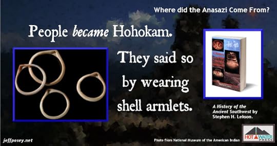

People became Hohokam. Perhaps the most conspicuous and widespread markers of Hohokam were armlets of Glycimeris shell. Bivalve shells from the Gulf of California were carefully shaped into armlets and sometimes carved with symbols—birds carrying snakes, desert toads, and the like. Shell bracelets or armlets became a badge or marker of Hohokam; they had once been rarities, but after 700 they were ubiquitous. Someone in every sizable settlement had armlets prominently displayed on an upper arm. —Lekson
Hohokam are predecessor to—at least highly influential to the development of—the Anasazi. They stayed separate from the Anasazi, but they were probably the mother culture.
To the Anasazi, the people who lived over the mountains to the southwest, the canal-builders and ball-court players (the Hohokam)—they may have been the oddball cousins that upstanding members of the Chacoan Anasazi elite didn’t mix with anymore.
The Anasazi migrated from the north.

Some 700 years ago, as part of a vast migration, a people called the Anasazi, driven by God knows what, wandered from the north to form settlements like these, stamping the land with their own unique style. —NYTimes
From the north? The farmers of the Four Corners who, by rite of farming there, became Anasazi, came from the north?
Corn came from the south. Beans came from the south. Cotton came from the south. But the farmers themselves came from the north.
Did somebody call an ancient job fair convention? Wanted: Farms Down South. A horde of men, wanting to better themselves, migrated there to find growing corn and beans (seeds supplied from the south) make for an easy life, began pumping out children, and then spontaneously started building enormous stone buildings with remarkable architectural similarity.
Maybe the royal architect was from the north. With all his royal attendants, and when they arrived to find all these farming families with children like rabbits, he somehow convinced them to build enormous stone buildings.
It keeps coming back to that. What motivated them to build? What pushed them into a hierarchical society that directed enormous public projects?
Farming would have provided that calories. But something else provided the motivation.
What do Native Americans say about the Anasazi origin?

Modern Pueblo oral traditions hold that the Ancestral Puebloans originated from sipapu, where they emerged from the underworld. For unknown ages, they were led by chiefs and guided by spirits as they completed vast migrations throughout the continent of North America. They settled first in the Ancestral Puebloan areas for a few hundred years before moving to their present locations. —Wikipedia
Many worldwide indigenous cultures developed a mythology about the first people having emerged from under the ground, like being delivered from the womb of our mother the Earth, followed by a journey to find the right place to live.
But that doesn’t really tell us where the first Anasazi people came from.
The pre-Anasazi wandered across North America.
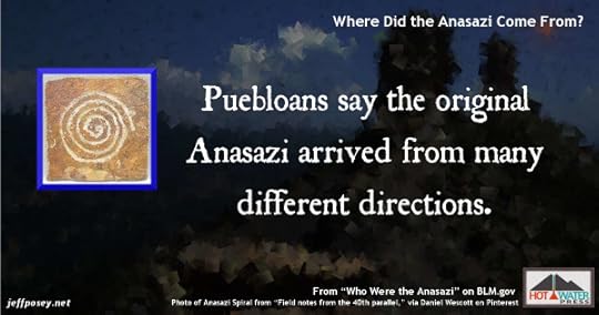
The ubiquitous spiral symbol of Anasazi rock art may be a “written record” of the vast wandering migrations across North America before they settled in the Four Corners region of the American Southwest.
According to Pueblo oral traditions, different groups came from different directions and points of origin before meeting to form the clans and communities of today. Modern Pueblos speak several different languages and do not share a common term for their ancestors. The Hopi name is Hisatsinom. —BLM
It’s difficult to imagine North American before the influence of Europeans. Our first accounts by eyewitnesses come years if not generations after the first wave of microbial sickness spread through the native population, pathogens entirely new to the population of the Americas, carried when Columbus stepped ashore in 1492.
Prior to all European contact, before horses and carts brought the Spanish in the 1500s, might there have been vast migrations of people and cultures, moving to their own rhythm across the plains and foothills like bison?
The original American settlers were pioneers, small migrations of their own. In ancient native America, migrations and wanderings would be part of survival from their deep roots as Paleo-Indians hunting the mega-fauna after the last Ice Age, and become part of the lore of the people.
Migrations were, and still are, literally in their DNA.
The Navajo say an evil magician forced their ancestors to build in Chaco Canyon.

The National Park Service (NPS) signpost at the path’s entrance vaguely describes Kin Klizhin as a place of “ceremonial function.” But [Taft] Blackhorse [a Navajo Nation archaeologist] explains that the kiva served as a human sacrificial altar and a center for ritual cannibalism. His story, like everything else about Chaco according to Navajo belief, is about the Gambler, an evil magician with a hooked, crooked nose who enslaved the ancient Navajo and forced them to build the great houses of Chaco. —Archaeology
This is interesting and all, but the Navajo didn’t arrive in the Four Corners region until about 1400. The Anasazi had mostly abandoned the region by 1295.
So, the Gambler didn’t do it.
Though, for the sheer sake of storytelling alone, there must have been an evil magician with a hooked, crooked nose. On that one, I hereby declare the Navajo exactly right.
And did you notice that reference to ritual cannibalism? That keeps coming up.
The Gambler of the Navajo arrived on a giant lizard.

According to [Taft] Blackhorse [a Navajo Nation archaeologist], the Gambler rode out to Kin Klizhin on a large reptile that was his guardian. His priests sacrificed humans at the site, and the Gambler, says Blackhorse, came here “to swallow their souls.” This is not the tale the NPS tells visitors to Chaco. —Archaeology
I love the imagery. An evil sorcerer riding a dinosaur, sacrificing humans and swallowing their souls. That’s a tale that could rival King Arthur and his Knights of the Round Table. Or The Hobbit and JRR Tolkien’s Lord of the Rings trilogy.
But it’s these very kinds of traditional oral stories that make you stop asking what the modern Native Americans believe about the Anasazi and start looking at hard archaeological evidence. Because while oral stories may have grains of truth hidden in them, they’re encased in the fanciful and absurd.
Where Did the Anasazi Come From? From a crazy man riding a giant lizard, of course.
The Anasazi were influenced most by neighboring Hohokam, Mogollon, and Mexican cultures.

Most of the later and so-called higher developments of the Anasazi came to them from the Hohokam and Mogollon groups, so that the climax that occurred about A.D. 1100 may be regarded as an accumulations of southern and possibly Mexican traits that were taken over by the Anasazi bit by bit—by trade, by drift, perhaps by war—and reworked to fit their ideas and cultural layout. —Martin p. 20
Trade, drift, and war. That’s an interesting triumvirate of culture change.
The Paleo-Indians had trade in shells, beads, and stone tools. They also had drift beyond our ability to imagine. But while violence and skirmishes undoubtedly took place, they didn’t resort to war until society was structured into high levels of power.
It’s axiomatic that the best way to prevent war is to resist cultural hierarchy and social inequality.
Were the Hohokam as regimented as their Anasazi cousins?

By 900 there were hints of hierarchy [in the Hohokam] not within but between towns, with the largest occupying positions of control at the heads of canal systems—positions of power. —Lekson
There was a lot going on in Central and North America around 900. The first year of construction on Pueblo Bonito was 919. The Toltecs of Mexico collapsed about this time. Cahokia (across the Mississippi from St. Louis) rose rapidly.
What was going on? Why all this sudden change? It’s as if the Native Americans, once a free-roaming people, spontaneously decided to put down roots and create large, complex, hierarchical societies exactly as the large, complex, hierarchical societies of Central America were collapsing.
And it’s interesting to draw the line from agriculture to “positions of power.” When you scale up agriculture from small gardens to huge fields that must be watered and maintained, people begin to specialize, and the specialists who control, say, the head gate to the irrigation system would, indeed, be far more powerful than a lowly bean picker.
So we’ve seen that warfare demands leadership and hierarchy, and now we see that large-scale agriculture demands the same.
Could one have come first? Large-scale agriculture that yields stores of surplus food would be something other people would want to take, by force if necessary. Hence agriculture could have planted the seeds that led to violence, and both would lead to an upper class that controls the masses.
Anasazi and Hohokam violence reached warfare levels by 850.
Intervillage squabbles escalated after 700, occasionally reaching levels approaching warfare by 850. Increasing violence also called for leaders, military or diplomatic. —Lekson p. 233
What might these squabbles-cum-warfare have been about? Probably the usual suspects when it comes to humans fighting humans (well, men fighting men): Food, water, women, territory, jealousy, revenge, religion.
I suspect all of these played a part in the violence that ripped through the area.
And I like Lekson’s suggestion for diplomatic leaders. You can’t fight all the time, or everyone loses. There must have been a system of long-distance runners, emissaries with the power to negotiate peace settlements, perhaps even under a system of diplomatic immunity.
The Hohokam unraveled when the Anasazi peaked.
By 1075, at the latest, Hohokam had begun to unravel [just as] Chaco burst forth to dominate the Plateu from 1020 to 1125. —Lekson p. 234
So if the Hohokam, centered in and around Phoenix and Tucson, were the mother culture to the Anasazi, what would their demise mean to the Anasazi leaders? Would it be a warning that the same could happen to them? Or some kind of proof that the Anasazi way was better?
1075 is an interesting year for the Anasazi world. The first building phase of Chimney Rock happened that year. New foundations that were never completed were laid at Pueblo Bonito. And, of course, the Hohokam began to fall apart.
With the rise of a powerful elite, most people became powerless commoners.

With the rise of would-be kings at Chaco, the people found themselves redefined as commoners. Villages with scores of separate individual homes dotted the landscape. Set on a low hill or prominence above the village stood a Great House [where the Chaco elites lived]. —Lekson p. 235
This sounds like the American antebellum South. The master is in the big house, the slaves are in their row houses.
Or feudal Europe, with the well-fed king and his court behind castle walls and mote, the plebes groveling to provide for themselves.
Without outright slavery, there would have been some system of taxation, of farmers sending a portion of their crops to support the elite.
Taxation works best when paired with both carrots and sticks—a good outcome if you pay up, and a bad outcome if you don’t.
What might that have been in the Anasazi world?
If you pay up, the high priests and would-be kings would direct the right ceremonies to ensure good weather and bumper crops. In a series of good years, this would look pretty good.
If you didn’t pay up, what then? Perhaps something violent.
Kivas evolved as community houses, but the elite of Chaco Canyon co-opted them for private use.

In many cases, Chaco elites were sometimes able to co-opt Great Kivas. The largest Great Kiva of its age was built within the walled plaza of Pueblo Bonito—the first and greatest Great House—about 1050. —Lekson p. 235
Is this evidence of an abuse of power?
Not necessarily. But it could be.
Imagine the stir among the lower priests when the first High Priest demanded a private kiva be built within the walls of his house of worship. For generations, kivas had been open to everyone. But now, the biggest and best was inside a gated community, for the exclusive use of the king, his court, and his bureaucracy.
The Anasazi occupation of the Four Corners.

The ancestral Puebloan homeland was centered in the Four Corners region of the Colorado Plateau—southern Utah, northern Arizona, northwest New Mexico, and a lesser section of Colorado—where their occupation lasted until 1280 or so. —BLM
What do they mean, a lesser section of Colorado? That lesser section includes Chimney Rock National Monument near Pagosa Springs, the most Chacoan of outliers. It was an important place. Not to the origin of the Anasazi, but to the time when Chaco Canyon was in ascendance.
And there’s Mesa Verde National Park in southwest Colorado, the most-visited Anasazi ruins.
So, yeah, I bristle at their use of the word lesser for the Anasazi occupation of southwest Colorado.
Were the Anasazi invading “occupiers” like Nazis?
It’s interesting that the BLM uses the word occupation. The Anasazi occupation of the Four Corners lasted until 1280. The Nazi occupation of France lasted until 1944.
Hmm. That bears some thought.
Where Did the Anasazi Come From? Maybe they came from the hyper-violent Toltec culture that was failing south of them in Mexico. Maybe splinter groups of Nazi-like invaders stormed onto the scene and forced all the farmers to start building enormous buildings modeled on Toltec/Mayan architecture.
The Four Corners is a hard place to live.
Temperature extremes in a normal year in the Four Corners are on the order of 100ºF from high to low. In a hard year, make that 120ºF. —Stuart/Anasazi America p. 15
So, why would people move there? The world is full of what would seem to be better places to live. Especially the bleak expanse centered on Chaco Canyon.
The Anasazi suffered mightily, there is no doubt. A few of the elites may have been comfortable most of the time, but everyone else tolerated conditions that would likely drive we modern Americans insane.
We don’t really know where the Anasazi came from.
No one knows precisely when the ancient Indian people who would one day be called Anasazi first arrived in the Four Corners. —Stuart/Anasazi America p. 13
I appreciate this flat admission from a respected Anasazi archaeologist.
At the end of the day, after we’ve examined all the evidence, we don’t know where the Anasazi came from.
Where Did the Anasazi Come From? Nobody knows.
Conclusion
I feel like we’ve taken a spiral-shaped trip trying to figure out where the Anasazi came from, and we’ve only managed to go in circles.
Do you know where the Anasazi came from?
Me either.
They either came from the north, or from the south (splinters of the collapsing Mexican Toltec culture), or rode into downtown Chaco on a giant lizard.
Yeah. I’m as enlightened as if mud were in my eyes.
This is background research for
The Next Skywatcher: Prequel to The Last Skywatcher Triple Trilogy Series, out in paperback, ebook coming soon!
Warning! This story contains graphic violence including cannibalism.
“I really enjoyed it. It was well-written.” —Thomas Windes, thirty-seven-year veteran Anasazi archaeologist with the National Park Service.
Raised by his beloved Sky Chief grandfather and a mysterious albino woman, Tuwa expects to become the next skywatcher.
When a strange star appears in the sky, so bright it shines during the day, the High Priest, backed by ultraviolent warriors from the South, demands blood sacrifice.
Tuwa’s grandfather, a vocal opponent of the foreigners, is murdered in a public ceremony, cooked, and served to the stunned crowd. Next in line are Tuwa’s adopted mother and the girl he loves, Chumana.
Unable to watch, Tuwa flees in a blind panic into dark wilderness where he’s rescued by a long-distance trader who collects orphans to protect him and carry his goods.
Three years later, Tuwa returns with his hardened band of orphans intent upon revenge—only to discover that the stakes are much higher than he had imagined.
Mere revenge may not be enough.
Jeff Posey writes novels inspired by the Anasazi culture of the American Southwest a thousand years ago.
“Cultures that have dramatically collapsed,” he says, “should at least compel us to dream up stories about how such things can happen.”
He does not, under any circumstances, advocate cannibalism.
Jeff’s Books on Hot Water Press
Sources
—Wikipedia. Ancestral Puebloan Origins on Wikipedia.com.
—BLM. “Who were the Ancestral Pueblo People (Anasazi)?” Who Were the Anasazi on BLM.gov.
—Stuart/Anasazi America. Anasazi America: Seventeen Centuries on the Road from Center Place, by David E. Stuart
—NYTimes. “Vanished: A Pueblo Mystery,” by George Johnson, April 8, 2008, New York Times on NYTimes.com (Great overall article; good fodder for anything on why they disappeared)
—Archaeology. “Insider: Who were the Anasazi?” by Keith Kloor, Volume 62 Number 6, November/December 2009 issue of Archaeology Magazine, a Publication of the Archaeological Institute of America
—Lekson. A History of the Ancient Southwest, by Stephen H. Lekson
—Martin. Digging Into History, by Paul S. Martin (out of print and hard to come by)
Image Credits
Hohokam shell bracelet photo from the Infinity of Nations Art and History Collections of the National Museum of the American Indian at nmai.si.edu
Hopi woman and baby photo from “In the cavity of a rock” on inthecavityofarock.blogspot.com
Photo of Camuy Cave, Puerto Rico, entrance by manwithashadow on DeviantArt.com.
Photo of Anasazi Spiral from “Field notes from the 40th parallel,” via Daniel Wescott on Pinterest.
Photo of Four Corners via Wikimedia Commons: “4corner” by vicki watkins from USA – Four Corners National Monument. Licensed under CC BY 2.0 via Wikimedia Commons – https://commons.wikimedia.org/wiki/File:4corner.jpg#/media/File:4corner.jpg
Photo of wizard via Wikimedia Commons: “Arthur-Pyle The Enchanter Merlin” by Howard Pyle – http://www.oldbookart.com/2008/08/25/.... Licensed under Public Domain via Wikimedia Commons – https://commons.wikimedia.org/wiki/File:Arthur-Pyle_The_Enchanter_Merlin.JPG#/media/File:Arthur-Pyle_The_Enchanter_Merlin.JPG
Photo of Gila Monster lizard in public domain via U.S. Fish and Wildlife Service on Wikipedia article on George E. Goodfellow
Photo of German soldiers marching through the Arc de Triomphe on the Avenue des Champs-Élysées in Paris (June 1940), from Wikipedia article on “German military administration in occupied France during World War II”: “Bundesarchiv Bild 101I-751-0067-34, Paris, Parade deutscher Soldaten” by Bundesarchiv, Bild 101I-751-0067-34 / Kropf / CC-BY-SA. Licensed under CC BY-SA 3.0 de via Wikimedia Commons – https://commons.wikimedia.org/wiki/Fi...
The post Where Did the Anasazi Come From? appeared first on Jeff Posey.
July 15, 2015
Anasazi Food: What Did They Eat?
Eating isn’t just a matter of survival for sentient beings, but also a source of social interaction, of cultural pleasure, of occasional gastronomic delight.
Yet Anasazi food, especially in their rather frequent times of difficulty, likely descended into realms that would disgust we modern humans. Even their feasts might involve foods that we would find suspect.
Yes, the Anasazi must have had iron stomachs at the best of times.
Did the Anasazi grow all their food?
![“Agriculture and Other Food Sources,” on CliffDwellingMuseum.com. Prairie dog closeup: By Steve from washington, dc, usa (when prairie dogs plan world domination) [CC BY-SA 2.0 (http://creativecommons.org/licenses/by-sa/2.0)], via Wikimedia Commons.](https://i.gr-assets.com/images/S/compressed.photo.goodreads.com/hostedimages/1437112696i/15539634._SX540_.jpg)
For all of their reliance on domestic crops, the Ancient Ones did not abandon the foods of their nomadic forebears. Even in A.D. 1300, corn, squash and beans, alone, would not sustain them. They still hunted animals like deer, rabbits and prairie dogs. And they gathered wild plants for sustenance. The nuts of the piñon pine were eaten roasted or ground. They ate the ripe fruit of the banana yucca and dried the red fruit from the prickly pear cactus for later consumption. Pigweed and amaranth provided greens. —CliffDwelling
Prairie dogs. That’s not something you see on modern menus.
Let’s say you’re really, really hungry and you’ve just caught a prairie dog. What do you do with it?
How to cook a prairie dog
![http://www.nativetech.org/recipes/recipe.php?recipeid=138. Prairie dog closeup: By Steve from washington, dc, usa (when prairie dogs plan world domination) [CC BY-SA 2.0 (http://creativecommons.org/licenses/by-sa/2.0)], via Wikimedia Commons](https://i.gr-assets.com/images/S/compressed.photo.goodreads.com/hostedimages/1437112696i/15539635._SX540_.jpg)
From a modern Navajo recipe for prairie dog.
Ingredients
5 Fresh prairie dog (caught in the early spring)
Onions
Pepper
Salt
GarlicDirections
Clean and quarter prairie dog, pat dry, add onions, pepper, salt and garlic as you would any other seasoning. Place on grill and cook slowly for about 1/2 hour. Be careful not to overcook. —NativeTech
Sounds deceptively modern. The Anasazi did not have grills. And as calorie-starved as they must have been, they would not have wasted anything, including entrails. Obviously, they also would not have had onions and pepper, thought they would have had salt and other spices derived from wild plants.
Most likely, they would have roasted the prairie dogs whole in coals. Singed the hair off until pleasantly charred. And then gnawed everything edible.
I can imagine a family saving the softer cooked entrails for an elder with bad teeth.
How did they prepare corn?
![http://www.blm.gov/co/st/en/fo/ahc/who_were_the_anasazi.html#eat. Corn cob, 900-1275 AD, San Juan Anasazi, Sheep Horn Alcove, Utah - Natural History Museum of Utah. By Daderot (Own work) [CC0], via Wikimedia Commons](https://i.gr-assets.com/images/S/compressed.photo.goodreads.com/hostedimages/1437112696i/15539636._SX540_.jpg)
Corn with larger kernels arrived in the Anasazi world about A.D. 400. By the time the Chaco Anasazi flourished around A.D. 1000, it was ubiquitous.
Corn was dried and stored on the cob. Strips of dried squash hung in the storage rooms. Wild plant foods were also stored and prepared for cooking. Piñon nuts, sunflower and other seeds had to be winnowed and hulled before they could be cooked and eaten. Corn kernels were parched in jars that lay on their sides near the fire. —BLM
Parched corn must have been especially valuable as a traveling food. Official messengers, runners for the High Priest of Chaco Canyon, must have carried pouches of dried corn and munched it as they ran dozens, even a hundred or more, miles to significant outposts such as Chimney Rock National Monument in Colorado.
Did Anasazi food include cornbread?
![http://www.blm.gov/co/st/en/fo/ahc/who_were_the_anasazi.html#eat. Piki bread at La Posada, Santa Fe. By Alan Levine from Strawberry, United States (Piki Bread) [CC BY-SA 2.0 (http://creativecommons.org/licenses/by-sa/2.0)], via Wikimedia Commons](https://i.gr-assets.com/images/S/compressed.photo.goodreads.com/hostedimages/1437112696i/15539637._SX540_.jpg)
Women spent hours each day grinding corn into flour with manos and metates. Beans were soaked then cooked in large jars. Vessels full of stew or mush may have been placed directly over fires, or hot rocks were dropped into the contents. They probably made paper-thin piki (a Hopi word) by spreading corn meal batter on a hot greased rock. —BLM
Piki bread is a form of unleavened cornbread, so yes, they had that.
Imagine if, for any reason, they left the cornmeal batter out for too long and it spoiled—began to ferment. Would that result in a form of corn beer?
Did Anasazi food include corn beer?

The Chaco Canyon Anasazi demonstrated advanced knowledge in many fields, yet no evidence has emerged for brewing a very simple corn beer. Cultures throughout North America made corn beer with regularity during the Chaco time period. I do not know of any grain producing society on earth that did not at one time or another produce some type of alcoholic beverage. As far as I can discover, no study has been undertaken to investigate whether corn beer might have been made by the sophisticated Anasazi. Certainly, corn beer is very easy to make and in moderate quantities can be very beneficial for general health due to its high caloric and mineral content. The making of corn beer on a large scale for religious ceremonies would have given the Chaco “elites” tremendous power over distribution of this “sacrament” to surrounding populations. The making of corn beer could very well be the overriding reason that Pueblo Bonito contains such a great number of small round rooms that could have been used as granaries. The making of corn beer may very well provide the avenue for research into the use of the large round rooms or what have been previously identified as “giant kivas.” This is another point for investigation which will provide the ultimate answer for the Pueblo Bonito Great House as well as the entire Chaco Culture. (Disclaimer: To date, there has been no conclusive evidence for corn beer production.) —CanyonsWorldwide
With corn beer comes drunkenness, and with drunkenness comes…well, all sorts of wild and crazy human behavior.
I can imagine the proprietor of a micro-corn-beer brewhouse setting up shop in a well-shaded lean-to against the wall of Chaco Canyon, perhaps in sight of the big houses being constructed. At the end of the work day, the stonemasons and menial laborers gathering to blow off a little steam from working all day in the sun.
Would the High Priest and his courtiers have approved? Perhaps tacitly? Like a tolerated black market? Quite likely. Human nature is predictable in that way.
But I get ahead of myself. There’s no evidence they brewed corn beer. And yet…they must have. It’s almost inconceivable that they alone, among all other corn-producing societies, did not.
Did Anasazi food include big game?
![http://www.blm.gov/co/st/en/fo/ahc/who_were_the_anasazi.html#eat Bighorn Sheep. By Magnus Kjaergaard (Own work) [CC BY 3.0 (http://creativecommons.org/licenses/by/3.0)], via Wikimedia Commons](https://i.gr-assets.com/images/S/compressed.photo.goodreads.com/hostedimages/1437112696i/15539639._SX540_.jpg)
Mice and rabbits were probably more important sources of meat than larger game such as deer or bighorn sheep. Among the larger game animals, wild sheep apparently were more abundant than deer. Large animals were butchered at the kill site. Back at home the meat was roasted, stewed, or dried for jerky. Long bones were cracked to extract marrow, and hides were cured for other uses. —BLM
The larger game, such as bighorn sheep, must have, therefore, been a special treat.
Would that have been reserved for the elite, the High Priest and his court?
Hunters and family clans that provided delicacies and special treats to the powerful would have likely curried favor, which means it likely happened.
The Anasazi were known to raise turkeys—did they eat them?
Turkeys were domesticated and used mainly for feathers, or as pets. They also were good for keeping bugs out of gardens. There is little evidence that turkeys or turkey eggs or dogs were eaten. —BLM
That is truly surprising to me. They raised turkeys, but there is little evidence they ate them or their eggs.
If you were faced with a decision for dinner: Turkey or prairie dog, which would you choose? Yeah, me too. Roasted turkey thigh, please.
Did they hold turkeys in some kind of reverence? Dogs, too?
As usual, we have more questions than answers.
What was the most-important non-meat Anasazi food source?

Yucca root was among the most important food resources. It was peeled, soaked, and slow-cooked in the laborious stone-boiling process. —Stuart/Ancient Southwest
Digging up a yucca root with stone and stick tools would not have been easy. And yet, the calories to dig and prepare it must have been less than the calories provided by eating it.
How big is a yucca root?

All yuccas have fleshy taproots that extend deep into the soil, mining nutrients and water from deeper soils. These deeper roots can extend more than 20 feet into the ground and can be several inches in diameter. It is these roots that contain the saponin compounds that are used as soap and as the foaming agent for root beer. They were also used as a food source by Native Americans. —Yucca HomeGuides
Twenty feet deep! How many calories does it take to dig that deep?
How many calories to dig hard for one hour?

Total calories expended to dig a ditch or shoveling for one hour is 578. —CalorieLab
I’m getting pretty far off track of Anasazi food here, but this is fascinating. Let’s take it a little farther.
How many calories are in a cooked yucca root?

There are 49 calories per ounce of boiled yucca root. —MyFitnessPal
So let’s do the math. If it’s 578 calories to dig hard for one hour to excavate a yucca root, and each cooked ounce of yucca root yields 49 calories, the Anasazi would have had to recover about 12 ounces of yucca root per hour of digging just to break even.
To do better than breakeven, they would need to extract about a pound (16 ounces=784 calories) per hour of hard labor.
At best, this is a hard way to go.
Makes you wonder how they concentrated enough calories to enable log-carrying for sixty miles or more, and for building the enormous stone structures in Chaco Canyon.
What else did they eat?

[G]rasses, roots, berries, nuts, seeds, rodents, and reptiles were undoubtedly eaten more often than large game. —Stuart/Ancient Southwest
Reptiles, eh?
Lizard on a stick, roasted over a fire, anyone?
What were other common Anasazi foods?

Among the wild plant foods known to have been collected for food…are tansy mustard; fruits of yucca, cactus, and chokecherry; piñon nuts and juniper berries; and seeds of amaranth, goosefoot, purslane, and grass, especially Indian ricegrass. —Wild Plants
In other words, the Anasazi were still hunter-gatherers, as well as farmers and gardeners, when they blossomed as a culture.
Any way you look at it, gathering Anasazi food was difficult. They were likely always at the edge of starvation, except for the elite, who had concentrated stores of food at their big houses in the canyon.
Archaeological evidence supports that. Most Anasazi bones show signs of malnutrition, with the exception of those buried with high-value items such as turquoise and special pottery.
What Anasazi Foods and Eating May Have Been Like
 From The Witchery of Flutes: Forty-seven short dramas of Anasazi daily life.
The Fat Man’s Chance
The shadows moved precisely along the wall of the Great House as if it were a giant sun dial. Against the north wall of the canyon, in contrast to the precision of the stone structure, ran a ramshackle like of lean-tos built with spindly sticks and scraps of cloth and animal hides. Beneath the shade of one sat the rarest resident of the canyon: a fat man. In a land of people made thin by constant physical labor and the threat of famine, the Fat Man stood as the only evidence that humans were capable of accumulating layers of body fat.
Lightfoot jogged across the canyon floor with two boys from his gang. The Fat Man’s headquarters sat in an indention in the cliff wall, a sort of corner in the long east-west run of the canyon, and men thronged there as if for a prize fight — which, indeed, the Fat Man sometimes sponsored.
Today, the action included only the usual games of chance, the endless supply of corn beer, and the draped-off rooms of the prostitutes.
Lightfoot knew the bodyguards and they knew him. “Can we see him?” Lightfoot asked.
“He’s busy,” said the guard with the broadest shoulders.
“He’s busy eating,” said Lightfoot. The guards laughed and allowed the boys inside. They passed the giant ollas from which old women served corn beer and a room where a curtain had been pulled back showing two naked women with men on top of them, a crowd of men watching, some openly masturbating. Lightfoot looked away, but his two companions gawked as if they’d never seen such a thing.
They found the Fat Man with a large platter of sweet corn dumplings, mugs of corn beer, and the picked-clean carcass of a roasted bird.
“Ah, my light-footed young renegade,” the Fat Man said. “Come, eat and drink.” He ignored the other boys, who alternately eyed the food and stared at the ground.
Lightfoot sat facing the Fat Man and gingerly took one corn dumpling and ate it. The Fat Man handed him a mug, and he drank.
“Now, what brings you to the Fat Man’s house of pleasure?” His eyes gleamed with wetness.
“I have friends who need help,” Lightfoot said.
“What kind of friends?”
“This kind of friends.” Lightfoot pushed aside the plate of corn dumplings and poured a pile of human teeth, each filed to a point, from a pouch.
The Fat Man leaned forward with effort and grabbed a handful of sweet dumplings. He examined the pile of teeth as if they meant nothing. “What are these?”
“Fifty-three pointed teeth from the heads of two-dozen Másaw Warriors.”
The Fat Man stopped eating and stared at Lightfoot. “Somebody killed two-dozen Másaw Warriors?”
Lightfoot nodded.
“Who?”
“My friends who need help.” The Fat Man’s eyes narrowed. Lightfoot told the story of the fifty-seven pointed teeth, of the boy, Tootsa, who kept four teeth for himself, and of the band of orphan warriors who were hidden in a side canyon to the southeast.
“What do they want?” asked the Fat Man.
“To get close enough to the High Priest and the Chief Másaw Warrior to kill them.”
The Fat Man’s eyes wandered back and forth over the room and he clasped his hands over his belly. “If they managed to do that, it would change everything,” he muttered. “I would love to move out of this hovel into the Great House.”
He turned his attention to Lightfoot. “Send this orphan warrior leader to me. I will help him if he will agree to help me.”
He waved Lightfoot and his two friends away, and then struggled to his feet. He scooped up the pile of pointed teeth and put them back into the pouch, which he slipped into an inside pocket. Then he walked to the edge of the shade, where he stared long and hard across the bright canyon floor at the gleaming whitewashed Great House of the High Priest.
Author’s Note: Isn’t it the story of the human condition that the guy who is atop the black market secretly wants to be respectable and to live in the great shining houses of the legitimate leaders (insofar as they’re legitimate, which is almost always suspect)? Yeah. Of course.
I don’t know if there really could have been a fat man in the Anasazi culture, which was so obviously calorie-starved. But if there were, it would be among the top elite, or the one who controlled the black market.
This is background research for
The Next Skywatcher: Prequel to The Last Skywatcher Triple Trilogy Series, out in paperback, ebook coming soon!
Warning! This story contains graphic violence including cannibalism.
“I really enjoyed it. It was well-written.” —Thomas Windes, thirty-seven-year veteran Anasazi archaeologist with the National Park Service.
Raised by his beloved Sky Chief grandfather and a mysterious albino woman, Tuwa expects to become the next skywatcher.
When a strange star appears in the sky, so bright it shines during the day, the High Priest, backed by ultraviolent warriors from the South, demands blood sacrifice.
Tuwa’s grandfather, a vocal opponent of the foreigners, is murdered in a public ceremony, cooked, and served to the stunned crowd. Next in line are Tuwa’s adopted mother and the girl he loves, Chumana.
Unable to watch, Tuwa flees in a blind panic into dark wilderness where he’s rescued by a long-distance trader who collects orphans to protect him and carry his goods.
Three years later, Tuwa returns with his hardened band of orphans intent upon revenge—only to discover that the stakes are much higher than he had imagined.
Mere revenge may not be enough.
Jeff Posey writes novels inspired by the Anasazi culture of the American Southwest a thousand years ago.
“Cultures that have dramatically collapsed,” he says, “should at least compel us to dream up stories about how such things can happen.”
He does not, under any circumstances, advocate cannibalism.
Jeff’s Books on Hot Water Press
Sources
—Stuart/Ancient Southwest. The Ancient Southwest: Chaco Canyon, Bandelier, and Mesa Verde, by David E. Stuart
—Wild Plants. Wild Plants and Native Peoples of the Four Corners, by William W. Dunmire and Gail D. Tierney
—CliffDwelling. “Agriculture and Other Food Sources,” on CliffDwellingMuseum.com.
—BLM. “What did they eat, and how did they prepare their food,” Who Were the Anasazi on BLM.gov.
—NativeTech. “Grilled Prairie Dog” on NativeTech.org.
—CanyonsWorldwide. “The Last Great Mysteries of Chaco Canyon Anasazi Full Circle—Paquimé to Chaco and Return,” by Richard D. Fisher on CanyonsWorldwide.com
—Yucca HomeGuides. “What Type of Root System Do Yucca Plants Have?” on HomeGuides.sfgate.com.
—CalorieLab. “Detailed results for calories burned by Shoveling, digging ditches” on CalorieLab.com.
—MyFitnessPal. “Calories in Yucca Boiled Yucca Root” on MyFitnessPal.com.
Image Credits
Prairie dog closeup: By Steve from washington, dc, usa (when prairie dogs plan world domination) [CC BY-SA 2.0 (http://creativecommons.org/licenses/b...)], via Wikimedia Commons
Corn cob, 900-1275 AD, San Juan Anasazi, Sheep Horn Alcove, Utah – Natural History Museum of Utah. By Daderot (Own work) [CC0], via Wikimedia Commons
Piki bread at La Posada, Santa Fe. By Alan Levine from Strawberry, United States (Piki Bread) [CC BY-SA 2.0 (http://creativecommons.org/licenses/b...)], via Wikimedia Commons
Discontinued Koff Indian Corn Beer. “Koff Indian Corn” by Raimo Miettinen – Own work. Licensed under CC BY-SA 3.0 via Wikimedia Commons – https://commons.wikimedia.org/wiki/File:Koff_Indian_Corn.jpg#/media/File:Koff_Indian_Corn.jpg
Bighorn Sheep. By Magnus Kjaergaard (Own work) [CC BY 3.0 (http://creativecommons.org/licenses/b...)], via Wikimedia Commons
Wild Turkey. “Gall-dindi” by Riki7 – Own work. Licensed under Public Domain via Wikimedia Commons – https://commons.wikimedia.org/wiki/File:Gall-dindi.jpg#/media/File:Gall-dindi.jpg
Yucca Root. By RD on Flickr, licensed under Creative Commons.
The post Anasazi Food: What Did They Eat? appeared first on Jeff Posey.
July 8, 2015
Mysteries of the Chimney Rock Anasazi Observatory
Why did Anasazi skywatchers focus so much energy on the patch of sky between the twin towers of Chimney Rock National Monument near Pagosa Springs, Colorado? What did they find and how did they show that they found it? Why was it so important to the Chaco Canyon Anasazi?
Every 18.6 years, the full moon rises between the Chimney Rock spires

The majestic natural stone pillars of the Chimney Rock formation have a unique connection to the major standstill of the moon. Seen from the Great House Pueblo, the stone towers are slightly out of line with each other, framing a narrow window of sky between them. At sunset near the day of the Winter Solstice during the [Major Lunar Standstill every 18.6 years], the full moon rises between the stone pillars, caught in this thin window of sky. —Major Lunar Standstill
Compared to the simple rising and setting of the sun and stars, the moon travels a complex, and often perplexing, cycle along the horizon.
Can you imagine the astonishment of the first skywatchers to realize that the full moon rose framed between the Chimney Rock spires, and their further realization that it does so predictably every 18.6 years? Such celestial knowledge would likely have impressed the powerful elite at Chaco Canyon, themselves so tied to watching the sky and cycles of the moon and sun.
Might the rulers of Chaco have sent an emissary, perhaps a high-ranking skywatcher/priest, to oversee the building of a sacred observatory (the great house at Chimney Rock)? Might the best architects and construction managers have joined him?
Based on the dates (derived from tree-ring dating) of construction at Chimney Rock, they coincided with lunar standstills. In other words, yes, there is a strong suggestion that the Chaco Canyon power structure was involved with building, occupying, and using Chimney Rock as an important window into celestial mysteries.
Why would a Chimney Rock Anasazi great house wall align with the Crab Nebula Supernova?

Architecturally, the long walls of the [Chimney Rock] Great House are not parallel. The northerly east-west walls line up with a small basin carved in solid bedrock 2,000 feet southwest of and below the Great House. If you stand at the stone basin and look at the northerly wall of the Great House at the time of summer solstice, you will see the sun rise centered on this wall. Viewed from this same stone basin, the southerly point on the Great House lines up to a spot in the sky where the Crab Nebula Supernova appeared for more than three weeks around July 4 in the year A.D. 1054. —Archaeoastronomy
What power lies in building a wall that points to a spot in the sky where a strange new Day Star That Faded appeared? A reminder that “there’s where it happened”? Or did they believe some kind of spiritual force flowed from that spot in the sky and concentrated at the Chaco-style great house with a wall that points at the spot?
And surely there were skeptics. What if pointing to the spot in the sky enraged the mysterious powers of the Day Star spirit? What if it wasn’t enough to appease it?
At the spot up on Chimney Rock where the observatory is built, little native stone was usable. That means it all had to be carried up a narrow, steep trail, along with wooden beams, plaster, and water (to mix with the plaster).
I keep thinking about the morning that Day Star appeared. Like a hole burning through the sky, quite unlike anything any living being had seen (without the use of psychotropic plants). It must have been shocking.
Any skywatcher priest who failed to predict it would lose esteem and respect. And there was no way to predict it.
I imagine the head Chimney Rock Anasazi priest did some fast talking to save his skin.
“Why didn’t you see this coming?” demanded the High Priest in the canyon. He wore a mask to hide him from the constant gaze of the glaring Day Star, even inside his round chamber.
“Such a thing has never happened before. At least not for generations. We have stories that tell of another one long ago, but they are not like the predictable movements of the sun and moon and wandering stars.” The old skywatcher wore a turkey-feather robe that hung to his calves and gripped a gnarled staff taller than his head.
“Perhaps it’s a sign to abandon the Twins. To stop watching the sky. Perhaps if you’d stayed in the Center Place like I warned you, this never would have happened.” The sun priests to the left of the High Priest turned their heads at an angle to the old skywatcher, a sign of respect for not looking directly at him while the High Priest scolded him, but also a sign that they saw and acknowledged the skywatcher and his mistake. It was as close to gloating as they would allow themselves in the High Priest’s sacred chamber.
“I propose a wall,” said the old skywatcher. “Of a new great house. A wall that points directly at the spot where the Day Star appeared. To honor its spirit and to show we are not frightened by it.”
The High Priest studied the old skywatcher. “I like building. The bigger the better.”
The top sun priest faced the High Priest, an unspoken request to speak. The High Priest nodded.
“Anything we do up at the Twins will detract from what we build here in the canyon,” said the sun priest. “Every man we can spare is working in the canyon now. I do not think we should build any new walls up at this man’s Twins.”
“I can provide the men for the labor,” said the skywatcher.
“You have men to spare? Why did you not send them here to me?” asked the High Priest.
The old skywatche wavered. “I will send them here if you prefer.”
The High Priest scratched his nose. “Send ten men to me for ten summers. That’s your penalty for not predicting the Day Star. After that, we shall see about building your wall.”
I just make this stuff up. But surely discussions and power plays like this happened all the time, just as they do today. It’s a basic human condition.
What social value is there in watching and predicting celestial events?

The Ancestral Puebloans established an impressive base of calendrical knowledge. This knowledge was imbedded in community design at Chimney Rock…. The irregular horizon provided by the San Juan Mountains is a perfect backdrop for establishing a solar calendar. Priests observing the movement of the sun from south to north and back again to the south could accurately predict important times of the year such as the equinoxes and solstices. These events were probably critical in scheduling festivals and activities involved in planting and harvesting crops. This information could have been communicated easily to other parts of the Chacoan World. —Archaeoastronomy
I’ve been a gardener for decades, and while fixed dates such as the equinoxes can be used for guidelines about when to plant, there are better ways. My grandfather, for instance, wouldn’t plant black-eyed peas until the local mesquite trees leafed out.
Was the agricultural world of the Anasazi significantly different than that? Did they need to know the specific celestial dates to plan the planting of their corn, beans, and squash?
I guess I just don’t buy it. The behaviors of plants and animals are a better guide for planting and harvesting crops than a hard-and-fast celestial date.
That leaves ceremonial dates. I can imagine a world in which the wide sky and bright sun dominate the day, and the star-strewn dome and pale moonlight dominate the night. I can imagine these becoming symbolic in ways we modern humans can barely grasp: the daily birth and death of the sun, the monthly progression of the phases of the moon, the alignment and patterns of the wandering stars (planets) against the background of fixed stars.
In a landscape such as this, using their big human brains, the Anasazi would have tried to categorize and make sense of their world.
I can imagine the precise alignments possible using the giant twin columns of stone at Chimney Rock, and when everything is just right, a signal bonfire is lit. Watchers on Huerfano Mesa, roughly halfway between Chimney Rock and Chaco Canyon, would light their own signal bonfire when they saw the spot of blazing fire atop Chimney Rock. From Huerfano, watchers in Pueblo Alto, the high house at the rim of Chaco Canyon above Pueblo Bonito, would have shouted or sent runners or lit their own signal fire that would send the high officials at Pueblo Bonito into a frenzy of ceremonial activity.
That’s likely the true value of a place like Chimney Rock.
When were the Chimney Rock Anasazi structures built?


There is debate over when the Chimney Rock Great House was constructed. One wood sample dates to A.D. 1076 and has been suggested as representing the earliest construction phase of the structure; the MLS [Major Lunar Standstill] was visible in A.D. 1076. Most wood samples date to A.D. 1093-1094, another MLS; this date represents either construction of the structure or a major remodeling episode. This may be nothing more than coincidence. However, researchers in archaeoastronomy, the study of how ancient people related their lives and world to the sky, see more possibilities. Malville [Dr. J. McKim Malville, professor of Astrophysics at the University of Colorado at Boulder] proposes that Chimney Rock’s people were more than just aware of these events. He suggests they celebrated them, in part, by constructing the Great House to mark and revere the beautiful and rare lunar events captured or protected by Chimney Rock’s twin monoliths. Interestingly, new wood samples recovered during the 2009 excavations at the Great House date to earlier Northern Lunar Standstills (e.g., A.D. 1018) and minor lunar standstills (A.D. 1011). The reuse of wood salvaged from earlier structures probably accounts for the presence of these samples and may represent earlier commemorative construction events. —Major Lunar Standstill
Tree-ring dating can tell us with great and accurate precision when a tree was cut, but it cannot tell us when construction took place.
I tend interpret tree-ring dates as logging activity. Perhaps the lunar events spurred the ancient ones into action first by cutting trees. Maybe because they believed the living spirits of the trees could be somehow captured by cutting them down, and under the influence of whatever celestial event motivated them, they believed the logs had greater value.
After they were cut and de-limbed, and cured and dried to make them lighter, then they would have been carried to a building site. That could happen over the course of several years. And then after that, building would commence.
Maybe. Maybe not. No one really knows, and we likely never will.
What is a Major Lunar Standstill, anyway?

The moon’s orbit of Earth oscillates or wobbles, gradually causing the moon to rise at different points on the horizon over the years. The entire cycle of wobbling north to south and north again takes 18.6 years. At each end of its swing, the moon appears to pause for about three years, rising at the same point on the horizon before beginning to move back toward the opposite end of the swing. This pause is known as a MLS [Major Lunar Standstill]. —Major Lunar Standstill
The rising of the full moon through the twin spires of Chimney Rock would not have been a single event. There would not be one date when you had to be in the right spot at the right time to see it.
But, rather, over the course of three years, every time the full moon rose, it would do so between the Twins. There would be thirty or so opportunities to watch the moonrise.
I imagine toward the end of the window of opportunity, pressure would go up to view it, pilgrims would set aside everything, and march toward the Twins of Chimney Rock.
This is background research for
The Next Skywatcher: Prequel to The Last Skywatcher Triple Trilogy Series, coming soon!
Warning! This story contains graphic violence including cannibalism.
“I really enjoyed it. It was well-written.” —Thomas Windes, thirty-seven-year veteran Anasazi archaeologist with the National Park Service.
Raised by his beloved Sky Chief grandfather and a mysterious albino woman, Tuwa expects to become the next skywatcher.
When a strange star appears in the sky, so bright it shines during the day, the High Priest, backed by ultraviolent warriors from the South, demands blood sacrifice.
Tuwa’s grandfather, a vocal opponent of the foreigners, is murdered in a public ceremony, cooked, and served to the stunned crowd. Next in line are Tuwa’s adopted mother and the girl he loves, Chumana.
Unable to watch, Tuwa flees in a blind panic into dark wilderness where he’s rescued by a long-distance trader who collects orphans to protect him and carry his goods.
Three years later, Tuwa returns with his hardened band of orphans intent upon revenge—only to discover that the stakes are much higher than he had imagined.
Mere revenge may not be enough.
Jeff Posey writes novels inspired by the Anasazi culture of the American Southwest a thousand years ago.
“Cultures that have dramatically collapsed,” he says, “should at least compel us to dream up stories about how such things can happen.”
He does not, under any circumstances, advocate cannibalism.
Jeff’s Books on Hot Water Press
Sources Cited
—Archaeoastronomy: Chimney Rock National Monument, Colorado, “Archaeoastronomy,” by the Chimney Rock Interpretive Association
—Major Lunar Standstill: Chimney Rock National Monument, Colorado, “Major Lunar Standstill,” by the Chimney Rock Interpretive Association
Additional Sources
—In the Shadow of the Rocks: Archaeology of the Chimney Rock District in Southwest Colorado, by Florence C. Lister
—Chimney Rock History on Wikipedia
—Chimney Rock Archeological Area, by Curt Van Fange on DesertUSA.com
—Chimney Rock Ruins, by Norm Vance, reprinted from The Anasazi Illustrated, on PagosaSprings.com
Other useful sites
List of Anasazi Sites in Colorado, by Gregory H. Bondar, lecturer in anthropology and archaeology at Penn State University and the University of Pittsburgh
Major Anasazi Regions and Sites on CliffDwellingsMuseum.com
The post Mysteries of the Chimney Rock Anasazi Observatory appeared first on Jeff Posey.
July 7, 2015
Out of Chaco: The Great Anasazi North Road
Why would a culture with no wheel and no beasts of burden build thirty-foot-wide roads that run straight as arrows for hundreds of miles?
Obviously, these roads are not like we think of roads (as pathways for cars and trucks). Were they for walking? Or did they mean something altogether different?
Were there prehistoric roads before and after Chaco in the American Southwest?

Roads played an important role in the Chaco culture, judging from their extent and the effort required for their design and construction. In the late florescence of the Chaco civilization (c. AD 1050 to 1125) elaborate, formalized roads were constructed. No archetype for these roads appears to have existed in the region before their development by the Chacoans, and a recent inventory shows they were not used after the Chaco civilization’s peak, about AD 1140. —Solstice Project
The Anasazi roadways are, then, completely out of any kind of context. No similar roads existed before or were created after the Anasazi. They are entirely unique to the culture and time period of the Anasazi of Chaco Canyon.
How many miles of roads are there?

The Chaco roads have been noted for their great width and unusual linearity, and they have been described as “extensively engineered.” The roads were developed by excavation to a smooth, level surface, and some included masonry construction. Approximately 300km [186 miles] of roads, including the Great North Road, have been documented in the last 15 years by aerial photography and ground investigation. —Solstice Project
Sounds like the interstate highway system of today. That’s a lot of road construction on the public dime. And they didn’t even have cars or wheels or horses or camels.
Some of the things the Anasazi did were a little creepy-strange. This is one of them.
Where does the Anasazi North Road start?

The Great North Road has its origin in several routes which ascend by staircases carved into the cliff from Pueblo Bonito and Chetro Ketl in Chaco Canyon, the two largest structures of the Chaco region. These routes converge at Pueblo Alto, a large structure located close to the north rim of the canyon. From there the road runs [nearly due north for 50 kilometers to] Kutz Canyon [south of Farmington, New Mexico]. It appears to terminate…at a stairway…that descends from the Kutz Canyon escarpment to the canyon floor. —Solstice Project
Makes me imagine a scene.
“Okay, men,” says the head stonemason. “Today we’re going to begin carving stairs into this sheer cliff face here. Any questions?”
“What’s wrong with the trail that goes up the wash?”
“Nothing, as far as I know. But this is what they want.”
And they all knew, of course, who they were. Those crazy fanatics in the big house.
The men all shake their heads at the insanity of it and begin pecking away at the cliff.
What is the road like?

For much of its length, it exists as two, and occasionally four, closely spaced, parallel roads. The road’s length and the complexity of its construction have led scholars to term it the “Great North Road.”
The road traverses rolling, sagebrush country, where the only prominent natural features in view, and then only from rises, are the distant snowcapped mountains to the north. The only major topographic relief are the canyons at each end. [T]here are no communities on the road’s course from Pueblo Alto to Kutz Canyon. Two large complexes—Aztec and Salmon Ruin [both near Farmington, New Mexico]—lie to the northwest, 20 and 30 km beyond the road’s terminus. Most of the outlying Chacoan communities are to the south, west and east of Chaco Canyon.
[A]t one location, a set of four “almost perfectly parallel” roads extending for 1.5 km is evident in aerial photography…. There is no satisfactory functional explanation for these redundant features. Yet the effort devoted to achieving them indicates they are not casual expressions of the Chaco culture. —Solstice Project
Two parallel roads. Four parallel roads. Even we modern humans don’t do anything like that except at…airports.
No, no, I didn’t say that. I am not implying that the Great Anasazi North Road could be an ancient runway. With an ancient taxiway. For landing two or more aircraft at once.
That’s crazy talk.
But it makes as much sense as why they really might have done it.
Can we still see the Anasazi North Road?

Because earth and vegetation have refilled the road, only limited vestiges of it are visible on the ground today and sometimes only under particular lighting conditions. —Solstice Project
I can attest to this. I’ve wandered around out there and I never saw anything that made me certain I was looking at the Great Anasazi North Road.
Looks like scrub desert to me.
After a thousand years, I wonder what our interstate highway system will look like?
Probably like scrub desert.
What else is strange about the road?

Construction of the road involved primarily the removal of earth and vegetation. Extensive road cuts were made where the road crosses land elevations. Near the large community buildings of the canyon, several stairways were sculpted and large ramps were constructed. Several of the multiple roadways connecting these stairways and ramps with Pueblo Alto were curbed with masonry. Along one of these segments there is a curious linear groove cut into the bedrock. The stairway at Kutz Canyon, now largely collapsed, was built as a series of platforms which were supported by juniper posts and crossbeams and packed with earth. The effort required for the road’s construction testifies to the serious purpose that attended the decision to plan and execute it. —Solstice Project
I’ve been to this place and I didn’t find any evidence of a wooden platform. But I may have been in the wrong place. It’s difficult terrain, at best.
I did stand and imagine a packed-earth wooden staircase leading down to the canyon floor from what likely would have been a fairly grand entryway from the terminus of the North Road.
People climbing up from below would have seen a straight, clear path through the desert scrub leading south to the sacred canyon of the center place.
Unless they did it all the time as, say, an official messenger, always running this way, huffing and puffing up the staircase, blowing his lungs at the top, shaking his head at the long, boring run from there to the canyon, daydreaming about giving it up for the easier life of a farmer.
How wide is the Anasazi North Road?

The road averages 9 m [30 feet] in width—wider than a modern two-lane road and far wider than any of the other prehistoric roads or trails of the Southwest outside of the Chaco cultural region. The width is greater than required for draft animals or wheeled vehicles. Since this culture had neither, the width seems especially excessive in practical terms. —Solstice Project
Nine meters meant nothing to the Anasazi. Thirty feet meant nothing. So what might this width have meant on their scale?
They were not tall people. At five feet each (for easy math, I’m leaving out the additional inches they had—they weren’t quite this short), that’s six people lying head-to-foot.
Or, giving two feet to each person standing shoulder-to-shoulder, that’s fifteen people.
It still doesn’t make any sense. And it makes me imagine a scene.
“You guys have been great that wide pathway we just finished,” said the master road builder. “Now we’re going to make one as wide as six of you lying head-to-foot.”
“Six of us?” one asks.
“That’s right. Six. Don’t mess it up.”
“What’s wrong with the foot-trail we’ve been using for generations?”
The master road builder snorts in frustration. “They want a wide new one, okay? Just do it!”
They. Those fanatics who live in the big house. The men shake their heads and begin clearing a road so absurdly wide surely the gods of common sense would swoop down and save them all…soon…they hoped.
Does the road go through a highly populated area (back in Anasazi times)?

The road, after leaving the ceremonial complex of Chaco Canyon, traverses the least developed region of the Chaco cultural area. —Solstice Project
This is one of those things that makes you slap your forehead and say, “What were these people doing?”
But, then again, when I drive across Texas toward the Four Corners, I’m well aware that I’m traversing the least developed region of the country.
Maybe there was a compelling reason to want to travel from Chaco to the northern regions that we simply cannot imagine or understand.
Maybe the road gave runners and long-distance traders (with their long processions of burden-bearers) an easier way to travel.
Is there evidence the roadway was heavily used?

It is estimated that only 10% of the ceramics found on the Great North Road are from the San Juan River communities, giving scant evidence of significant trade with them. The absence of hearths and ground or chipped stone in the road inventory suggests there was little encampment along the road. —Solstice Project
It’s a long road. Camping and resting points would be required for heavy use by average people.
But maybe pilgrims traveled the roads in a zombie-like daze, walking or jogging for the entire couple of days it would take to travel the length of the Great North Road.
Or maybe they rested without cooking food or making formal camps.
Or maybe everybody talked about taking a pilgrimage on the road, but rarely actually did it because they would rather stay home and listen to the skywatchers preach and argue.
Where does the Anasazi North Road go?

To summarize, the road’s great width and parallel routes, its ephemeral practical use, and apparent terminus at an isolated badlands canyon fail to justify, in functional terms, the effort entailed in its construction. The road apparently goes “nowhere” and displays a level of effort far out of proportion to the meager tangible benefits that may have been realized from it. In many important respects, the road appears to be its own reason for development—an end in itself. —Solstice Project
If the road goes nowhere, then either we cannot imagine or understand the practical reasons for it, or it has some ceremonial and religious purpose.
Was the Anasazi North Road used purely for ritual purposes?

There are several curious concentrations of [pottery] shards along the road at locations isolated from structures and without evidence of nearby encampment.… The extensive quantity of broken ceramics at Pueblo Alto has suggested to some analysts the possibility of large ritual gatherings involving dispersal of food items and deliberate breakage of vessels. —Solstice Project
I wonder about the practice of intentionally breaking perfectly good pots. A poor society would not do such a thing. Unless the consequences of not doing it were worse than the consequences of doing it.
If you break your pots that would store dried corn over the winter and protect it from being eaten by rats, resulting in starvation, this would not have become a widespread practice.
I wonder if special pots were made by “priest potters” especially for smashing to the ground at selected places along the Great North Road.
I wonder if there were competing ideas about which priest potter’s wares were best and most effective for sacred smashing.
I wonder if there were people you could pay to go smash the pot on your behalf.
I spend a lot of my time wondering.
What do modern descendants of the Anasazi have to say about roads?


Historic Pueblo cosmology and ceremony [has] frequent symbolic use of straight roads, mythic and ceremonial journeys to and from the north and the “middle place,” and attention to prominent topographic features as elements of a spiritual landscape. —Solstice Project
Ancient cultures everywhere lived in a very different world than our own, and the natural world would be a primary and universal influence. It’s not hard to believe that topographic features and cardinal directions would, therefore, elevate to religious and ceremonial significance.
Is the Anasazi North Road a religious symbol?

[T]he Great North Road, was laid out with remarkable precision in relation to the two [north-south] “verticals” to express not only primarily triadic site design and architecture of the centers, but the much earlier origin, evolution and framing of the entire Anasazi plateau itself. —Doxtater
It’s a little hard to figure out what Doxtater is talking about because he writes in the extremely stilted manner of academics.
I think what he’s saying is that Chaco Canyon was the “center place” of Anasazi religious beliefs and origin stories, and the entire landscape of northwestern New Mexico and southwestern Colorado was a giant sacred symbol for them. Their Great North Road is, therefore, a pathway for the spirits of ancestors and gods to travel back and forth from the land of the living to the spiritual realm.
Why is part of the Anasazi North Road not precisely north-south?

Copeland (2012), an archaeologist with the BLM in Farmington, NM (Totah area),…cautiously [suggests] that the only symbolic reason for [the Great North Road’s] less than precise cardinal layout might be [to mirror] the cant of the Milky Way. —Doxtater
The Milky Way, viewed in a clear, dark sky, does indeed resemble a great celestial roadway in the heavens. Before television ruined our desire to watch the sky for entertainment and guidance, you know the ancients would have held this in high regard. Especially in a landscape in which the air is dry and clear and the sky wide and big, like that of the Anasazi.
Who laid out the Great Anasazi North Road?
[T]he positions of the road at symbolic intersection points was clearly laid out by priest surveyors. The actual building of road segments, perhaps by pilgrim groups themselves across different years in the late 1000’s/early 1100’s, was not; they only needed to connect to the intersection points where structures were built and…alignment-related rites were performed. —Doxtater
“Priest surveyors” implies a religious fanaticism for the worship of direction as cosmological symbolism. Most native cultures I’ve investigated from around the world are attuned to directions to high points and the rising and setting of sun and moon.
The Anasazi, apparently, took that to such an extreme that it may have actually led to their demise, by diverting so many resources and calories from surviving that the culture eventually collapsed. A modern equivalent is the ongoing political argument about tax burdens and public expenditures.
I can imagine the priest surveyors lobbying various village chiefs to support them with calories (food subsidies) and labor (human services) in their grand plans. What dire consequences might they have predicted (threatened) if the village administrators didn’t go along? “The spirits of you and your children and your grandchildren will be trapped here forever if we do not build this Great North Road so that we all can join the spirits of our ancestors!”
I wonder what the farmers and laborers had to say about it? Did they grumble quietly that they were being taxed too heavily? Did they ultimately rebel? Or were they true believers who had faith that they were doing the work of the gods?
This is background research for
The Next Skywatcher: Prequel to The Last Skywatcher Triple Trilogy Series, coming soon!
Warning! This story contains graphic violence including cannibalism.
“I really enjoyed it. It was well-written.” —Thomas Windes, thirty-seven-year veteran Anasazi archaeologist with the National Park Service.
Raised by his beloved Sky Chief grandfather and a mysterious albino woman, Tuwa expects to become the next skywatcher.
When a strange star appears in the sky, so bright it shines during the day, the High Priest, backed by ultraviolent warriors from the South, demands blood sacrifice.
Tuwa’s grandfather, a vocal opponent of the foreigners, is murdered in a public ceremony, cooked, and served to the stunned crowd. Next in line are Tuwa’s adopted mother and the girl he loves, Chumana.
Unable to watch, Tuwa flees in a blind panic into dark wilderness where he’s rescued by a long-distance trader who collects orphans to protect him and carry his goods.
Three years later, Tuwa returns with his hardened band of orphans intent upon revenge—only to discover that the stakes are much higher than he had imagined.
Mere revenge may not be enough.
Jeff Posey writes novels inspired by the Anasazi culture of the American Southwest a thousand years ago.
“Cultures that have dramatically collapsed,” he says, “should at least compel us to dream up stories about how such things can happen.”
He does not, under any circumstances, advocate cannibalism.
Jeff’s Books on Hot Water Press
Sources Cited
—Solstice Project: “The Great North Road: a Cosmographic Expression of the Chaco Culture of New Mexico,” by Anna Sofaer, Solstice Project; Michael P. Marshall, Cibola Research Consultants, Corrales, New Mexico; and Rolf M. Sinclair, National Science Foundation, Washington, DC.
—Doxtater: “The Great North Road As Anasazi Origin Ritual: Chaco and Totah in context with triadic plateau structures,” by Dennis Doxtater, College of Architecture and Landscape Architecture, University of Arizona. This is a PDF document.
Additional Sources
—“The Chaco Road System – Southwestern America’s Ancient Roads: Did the Chaco Road have an Economic or Religious Purpose?” by Nicoletta Maestri, Archaeology Expert on About.com
—“Chaco Roads,” by John Kantner on Colorado.edu
—“The Mysterious Roads,” on Cultures.com
—“Ancient Roads, Modern Mapping: Evaluating Chaco Anasazi Roadways Using GIS Technology,” by John Kantner on Penn.museum (PDF)
—“All Roads Lead to Chaco Canyon,” by William R. Corliss from Science Frontiers #59, SEP-OCT 1988 on Science-Frontiers.com
Image credits
“Chaco Anasazi canteen NPS” by National Park Service (United States) – National Park Service Museum Collections: Chaco Canyon National Historical Park. Licensed under Public Domain via Wikimedia Commons – https://commons.wikimedia.org/wiki/File:Chaco_Anasazi_canteen_NPS.jpg#/media/File:Chaco_Anasazi_canteen_NPS.jpg
“Hopi Tawa Mural” by Fred Kabotie, National Park Service – http://www.nps.gov/common/uploads/pho.... Licensed under Public Domain via Wikimedia Commons – https://commons.wikimedia.org/wiki/File:Hopi_Tawa_Mural.jpeg#/media/File:Hopi_Tawa_Mural.jpeg
“Milky Way Night Sky Black Rock Desert Nevada” by Steve Jurvetson – Flickr. Licensed under CC BY 2.0 via Wikimedia Commons – https://commons.wikimedia.org/wiki/File:Milky_Way_Night_Sky_Black_Rock_Desert_Nevada.jpg#/media/File:Milky_Way_Night_Sky_Black_Rock_Desert_Nevada.jpg
The post Out of Chaco: The Great Anasazi North Road appeared first on Jeff Posey.


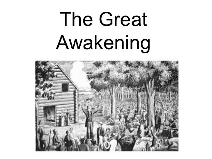
#/media/File:Arthur-Pyle_The_Enchanter_Merlin.JPG)
#/media/File:Koff_Indian_Corn.jpg)