
Pagosa 2015 Snapshots and Notes
Ah, Pagosa Springs, Colorado. I’ve been in love with this place since driving through with my parents on a family vacation in high school. At first, the attraction was cool mountains, lush forests, noisy streams, and thousands of miles of some of the best hiking trails in North America.
I’ve visited more than a hundred times since. I’ve solo backpacked more than 2,000 trail miles in nearby wilderness, and I’ve hiked another 500 or more with other people.
Now when I return to Pagosa, I see it through the foggy lens of time. A thousand years ago, this was the farthest northeast corner of the Anasazi Empire.
Twenty miles due east of Pagosa is Chimney Rock National Monument, home base of my historical novels about master skywatcher Tuwa and his astronomical observatory using a complex circle of stones and a record of events in knots and fringe in a long string record.
The mother hot spring of what is now Pagosa Springs must have been an active place (Pah-go-sah is a Ute word for “hot water”) a thousand years ago. The Anasazi outpost at Chimney Rock had line-of-sight communication with Chaco Canyon (via signal bonfires on Huerfano Mesa and Pueblo Alto), and the stone construction there is unmistakably of Chaco Canyon style.
The hot springs, a long day’s walk due east of the Twins (my historical fictional name for the dual spires of Chimney Rock), would have been a natural gathering place. Farmers from the foothills of the South San Juan Mountains—likely insulated from the rule of any High Priest in Chaco Canyon—would have known of it, bathed in its sulfur water, plastered themselves with its mineral mud.
New arrivals, ancestors of the Utes and their mountain-dwelling offshoots, would have come down to trade and take the waters.
And, of course, the elite of Chimney Rock, the master skywatcher and his monk-like acolytes and their wives and husbands would likely have made forays to the hot springs.
Pagosa Springs back in the day of the Anasazi would have been a Wild West town on the fringe between the hard-fisted rule of Chaco Canyon and surrounding wild tribes and clans.
When I tour Anasaziland, mostly desert and dry plateaus and canyonlands to the south and west, I’m struck by how foreign and different the Anasazi outpost of Chimney Rock must have been. Did emissaries of the High Priest in Chaco Canyon lobby to be assigned there? If not, what was wrong with them?
I’m not much of a photographer. I tend to get lost in moments and forget to snap the shot. I also use only a phone for pictures because I like to carry as little as possible. My buddy Mike supplements my photo collection here. He uses a real camera.
These are from my 2015 trips. I’ll add more from time to time as I dig through the digital brain of my phone from our trip in June. And I’ll add photos by others as they come in.
River, Marsh, Spring, and Ridge
The San Juan River flows like an overgrown mountain stream through Pagosa Springs and then runs west to the Four Corners area, where it turns southwest and ultimately joins the Colorado River that (sometimes) flows into the Gulf of California (also known as the Sea of Cortez) after cutting through the Grand Canyon.
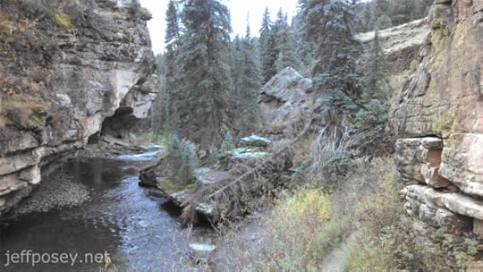
San Juan River
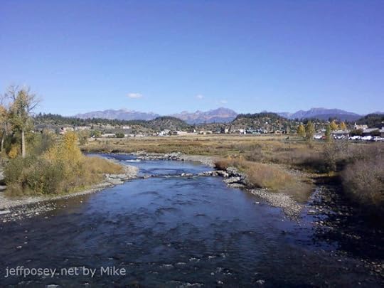
Looking north on the San Juan River toward Pagosa Peak (highest on the left) and the Weminuche Wilderness.
When I hike back into that area, it feels like I’m returning home. I’ve made at least fifty backpacking trips into those mountains, and more than double that many day hikes.
I’m a glutton for the punishment of hard wilderness walking, though five knee surgeries have slowed me down. My two-week-long, 100-plus-mile hikes are over.
I sure love looking up into that area from the river, though. I’ve been all up and down the Rocky Mountain spine from New Mexico to Montana. I’ve found places as pretty and appealing. But nothing more pretty and appealing than the San Juan Mountains of southern Colorado.
Why go anywhere else? Even in my mind, when I’m dreaming up my novels, my characters always end up somewhere in or around Pagosa Springs.
Warm River Marsh

Like pearls strung alongside the San Juan River downstream of the Mother Hot Spring in Pagosa Springs, a series of ponds begin with this one.
Faint steam rises in tendrils from the water, warm to the touch. As you walk along the concrete pathway, part of the town of Pagosa Springs River Walk, the downstream ponds cool until a finger plunged into the water detects no warmth at all and no steam tendrils rise from the surface.
Imagine the way this would stand out in winter, a haven for wildlife seeking warmth. In October, when I took this photo, a ring of green surrounded this pond, but the cooler ones to the west were already brown, giving in early to coming winter. A chorus of redwing blackbirds sang from the cattails, and the slip-trails of muskrat crisscrossed the marsh grass.
It’s a magical place.
The Ridge from the Marsh

From the river and its marshes rises this ridge of fractured shale. The river bends away to the left, eroding this black cliff. The warm marsh is also to the left.
From the top of this ridge, the view of downtown Pagosa Springs, the river, and the mountains to the north and east is spectacular.
In my mind it’s a place of drama. Because it overlooks….
The Mother Hot Spring

This is a shot (by Mike) from the ridge looking east. Just to the right of that fancy brown-topped building is the mother hot spring. The warm marshes and river are down and to the right.
Close-up of the modern Mother Hot Spring

This is what the mother hot spring at Pagosa Springs now looks like. In the old days, it was muddy marsh all around, hard to get to.
Now it’s easy to stare into the bubbly depths of what is advertised as the deepest hot springs in the world.
I like to stand on this ridge

This is the top of the ridge as it slopes west. This photo is facing the same direction as the earlier one that looks down on the mother hot spring.
That’s me at the top looking down the steep meadow that leads up to the cliff edge (just behind me).
Danielle and Vicki tuckered out before they got to the top and had to take a rest. I’ve never understood flatland lungs. I’ve always been able to go like a steam engine, thin air be damned.
But look at this place. Peeking over the ridge along which I’m standing you can see the mother hot spring and the flatland around it. That’s a powerful place to be if you want to spy on people down there.
I’ve got some imaginary drama planned for this place in The Last Skywatcher Series.
Reservoir Hill
The Pagosa Springs River Walk connects to a large town park called Reservoir Hill (as far as I can tell, it’s named that because they put a big water tank for town water up on the hill—I suppose I should give town leaders credit for not naming it Tank Hill), with miles of hiking and mountain bike trails, a meadow with a pavilion for concerts and outdoor gatherings, and a disc golf course that always seems to have at least a few people playing in good weather.
You can see it as the forested hill rising behind the mother hot spring in the photo taken from the ridge.
Cougar Bench of Pagosa Springs
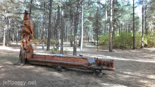
This carved bench, by artist Chad Haspels, is always a pleasant surprise.
Here’s a close-up in rather poor lighting.

The bench and carving has been recently restored, with a new coast of varnish applied. I’m glad they did that. It was getting rather worn and faded.
More here: Artwork Refurbished on PagosaSprings.com.
I wonder what artwork in wood the Anasazi and their contemporaries made in this area. Every culture, given wood and tools harder than wood (stone), has made carvings of their world. They certainly would have been familiar with the cougars (a.k.a. mountain lion and puma) in the area, some of the largest in the state.
The ancient ones would have appreciated this bench and its art.
Pagosa Peak from Reservoir Hill

From the top of Reservoir Hill is this panorama looking north to the cluster of mountains around the Fourmile Creek drainage, Pagosa Peak (12,640’) prominently to the left. I’ve climbed it twice. Failed on one other attempt.
On yet another venture, I climbed around it above tree line to get a line-of-sight to Chimney Rock National Monument (the Twins in my historical fiction parlance). I wanted to test whether a scene I’d already written could actually happen: Would a bonfire on the southwestern slops of Pagosa Peak above tree line be visible from the Twins? Yes, absolutely.
I sat for more than an hour imagining how a group of adolescent boys would do such a thing to surprise their grandfather skywatcher back at the Twins. If it didn’t happen, I would be surprised. In my fictional world, it definitely did.
Cumbres & Toltec Scenic Railroad
The name of this railway is mystifying. Toltec? Really? They were a culture more or less contemporaneous with the Anasazi, but centered 2,500 miles to the south near Mexico City. It’s highly unlikely that any true Toltec ever walked the line that became this railway.
We rode it at the perfect time to see spectacular fall foliage color, the first week of October.
Beginning of the Line

The steam engine of the Cumbres & Toltec Scenic Railroad sits ready to haul a long string of cars up the narrow-gauge line over a high pass between Antonito, Colorado, and Chama, New Mexico.
There’s a competing narrow-gauge railway (narrow to better navigate the tight twists and loops and turns necessary to find a grade up and down which a steam engine can haul people and lumber and minerals) that runs from Durango to Silverton, the Durango & Silverton Narrow Gauge Railroad Museum (yes, it’s a museum on iron wheels and rails).
I’ve ridden both, and given a choice, I’d take the Cumbres & Toltec line, though by a bare margin. When in doubt, take both!

My lovely wife Danielle and I are ready for the ride!
(No, I’ve never been to Alaska, despite the advertisement on my cap. My mother took an Alaska cruise this summer. She got to see glaciers and whales. I got the hat.)
Sagebrush Plains and Train

Before we climb into the mountains and spot our first fall foliage, the train loops through a high plateau of sagebrush as it gains elevation.
Top speed on the train is in the neighborhood of fifteen miles per hour. And the loops are so wide and get so close to each other at the necks of the loops, it’s often tempting to jump off the train, hike up a few dozen yards to the higher track, and wait for the slow train to come along again.
But I didn’t do that. The seats are comfortable. The clacking and swaying of the train is mesmerizing. I feel for the Anasazi who never had a chance to experience such a thing.
Color in Hiding

Ah, the first plume of hidden color among the evergreens.
Tufts of Color

And we begin to see more, with hints of reddish colors.
Blur of Fall Foliage
An aspen in full color close to the train seems to zoom by in a blur of bright yellow.
But we’re the ones “zooming” along at fifteen miles per hour.
Out the Train Window
After that flash-blur of color, you begin to pay more attention and look ahead to find scenes like this.
Fiery Red!

It almost looks like a smokeless forest fire.
Hoodoo and Fall Colors
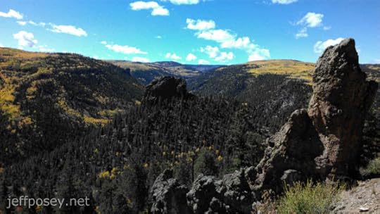
Beyond the hoodoo standing guard beside the tracks is a deep valley braced by mountains covered in fall color.
This is the kind of view that makes your eyes go dry because you don’t want to blink and miss even a microsecond of gorgeousness.
Train Hanging Over Valley

Don’t look down. Look out. The deciduous trees are completely segregated by color.
Vista of Color

Again, without the train.
Man, what a view.
Waves of Mountain Color

They’re like giant frozen waves of rocks and trees with shocks of yellow and orange.
Cliff and Train
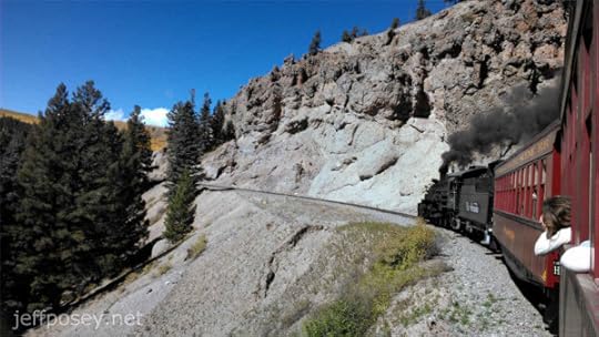
It’s not all color, even at peak times in the fall. Sometimes it’s cliffs, which oblige viewers at any time of year.
Noe the people hanging out the window. The back of my head is probably in hundreds of photos from people in cars father back.
This is a classic shot along this railway.
End of the Line

Finally, back in Chama, New Mexico, the engine gets to take a rest in the afternoon sun.
I’ve no photos, but the rail yard works, with all the mechanical maintenance and repair buildings and barns, is as fascinating as the train itself. The people who keep these relics running are smart, hard workers. (And they’re all covered in soot and grime—offer to shake the hand of any of them, and they back away with their hands up. “You’ll never get it off you,” I overheard one of them say.)
Piedra River Canyon Day Hike
Piedra River Trail Head
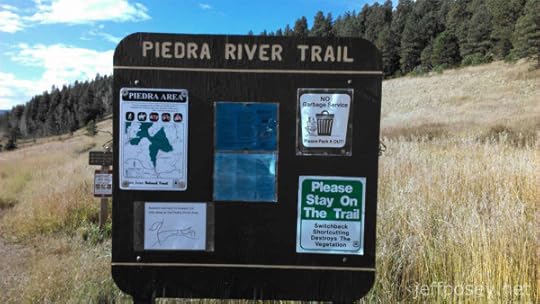
If you are ever in or around Pagosa Springs, Colorado, this is the best short day hiking trail around, according to me and my wife, Danielle.
Why? Short walk, a shade over two miles round trip (though you can go much farther if you want). Grade is easy. Trail is clear. And you cut through a wonderful little canyon.
Read more about it on TripAdvisor.
Meadow of Piedra River Trail
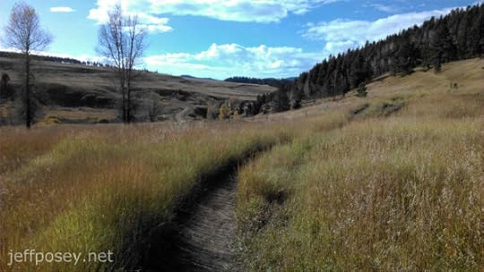
Your walk begins in a tilted meadow with the river (a big mountain stream, really) to the left.
A faint trail soon splits off to the right, up to some cracks in the rocks that have ice in them year-round. If you need more exercise, that’s not a bad side-trip.
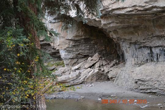
Down the Canyon

This is your first good view looking down the canyon. The stream rushes, the sun is warm, and river otters are said to ply the waters (I’ve never laid eyes on one).
Cliff Across the Way

I like this photo. The cliffs across the Piedra River from the trail, before you get down into the depths of the canyon.
Always walk slowly and look around a lot. Seeing is high-quality living.
Canyon of the Piedra River
This is the big payoff view of the Piedra River Canyon.
It’s not the only payoff view. There are hundreds more. Heck, every step gives you a slight variation on yet another payoff view.
The first time we walked this, we both kept saying, “Wow.”
It’s easy to see why the big blocks fall, with the river eroding them from the base like this.
The last time we were there in the spring of 2015, the water was maybe three feet higher. That adds a lot of background noise, let me tell you.
Dark Cliff of the Piedra River

Not a good photo, I know. Bad lighting. But it’s the most massive cliff profile you see on this walk.
From the road, there’s a short trail from a pull off that leads to the top of this cliff, so you’ll sometimes see people up there looking down on you.
When I see human figures up there, I set up for a picture and call up to them, “Step a little closer!”
Sometimes they do.
“Just a little closer!”
When they bite and come closer, I switch to video hoping to catch some visual drama.
(Note: I’m kidding, I’m kidding. I’d never do such a thing. Especially with my wife around.)
Girls Looking for Pretty Stones

Below that dark looming cliff, there’s a wonderful little sitting area beside the river. When you look down at the beach and into the cold, clear shallow water, there are countless colorful pebbles and stones.
Danielle and Vicki began picking out their favorites and setting them out to dry.
Warning: Be prepared to carry out a few more pounds than you carried in. Little blue and reddish pebbles still hide in the nooks and crannies of our car and fanny packs. We’ll never get them all back out again. We always travel with the tiny souvenirs of the Piedra River Canyon.
Cliff over wife and friends

Cliffs on the way out with Danielle, Vicki, and Mike for scale.
Would you climb those cliffs?
Me either, but people do. Climbing pitons for tying off the ropes of climbers cover this and other cliff faces. You’ll often see climbers making their way up, a partner on belay below, and an inevitable nervous dog or two looking up at their insane masters.
Cliff over Mike

More towering cliff, with Mike for scale.
Cliff over Danielle and Vicki

A typical view walking out, with Danielle and Vicki for scale.
Big blocks of the canyon wall have fallen over time toward the riverbed, and the trail winds in and out of them. It’s a magical place.
Cliff over Jeff

Now it’s my turn. When I take pictures, I’m never in them. I have to rely on the cameras of others to get a glimpse of me. Thanks, Mike!
Big Tree

That’s one big tree that dwarfs Vicki and Danielle. Look how it’s growing from that boulder. So, the boulder obviously has not shifted in the what, hundred-plus years it’s taken for this tree to grow?
I’ve spent the equivalent of years in deep back-country wilderness. It’s my experience that, while most people think the wilderness is a “wild” and active place, most of the time, very little happens. Bounders fall and sit the way they landed for hundreds of years.
And then another boulder falls.
My father, a World War II B-17 Flying Fortress veteran, says flying, even in war, is boring most of the time because nothing happens but getting there or getting back. But then there are the long moments of sheer terror.
When this big boulder finally rolls, will this tree feel the terror?
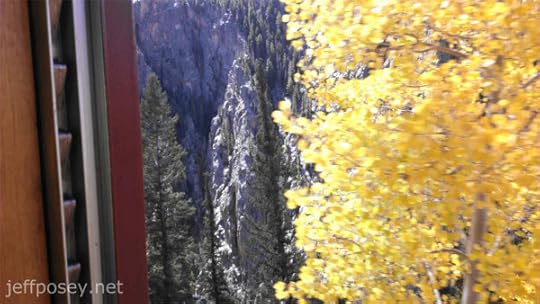
Treasure Falls Trail
This is one of the shortest hikes in the area, on the main highway (160) about halfway between Pagosa Springs and Wolf Creek Pass.
But the payoff is a wonderful waterfall.
Treasure Falls Sign

Note the “no restrooms.” There used to be one here, but they took it out, I don’t know why. It’s also so heavily used, it’s hard to find a private place to do your business. So it’s best to start this walk with an empty bladder.
Treasure Falls

This is not at the Piedra River Canyon, which is west of Pagosa Springs.
This is Treasure Falls, just off Highway 160 between Pagosa and Wolf Creek Pass, which crosses the continental divide.
A couple of years ago I solo hiked up and over Treasure Mountain from near these falls in a soaking rain. People think I’m crazy. But I loved it.
At the top, wet and bedraggled, an eagle flew low over me clutching a small animal, mouse or vole or chipmunk, and careened into the trees. I moved sideways and kept my binoculars on the spot and finally found the mass of sticks that must have been the nest.
No one else in the world saw that. Just me.
Have I mentioned how much I love hiking in deep wilderness? Moments like these stay with me forever. I have thousands of them, so many I’ve forgotten most. But they come back to me when I need them.
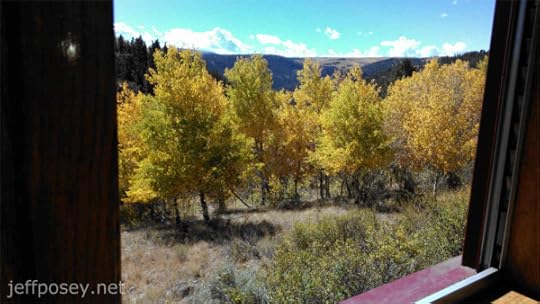
Treasure Falls from Afar

It’s just plain pretty no matter how you look at it.
Pagosa Lodging
We’ve rented more than a dozen homes through VRBO (Vacation Rentals By Owner). This is our favorite.
The Lewis Street Treehouse

This is the most comfortable place we’ve stayed in and around Pagosa Springs. Find out more on the VRBO listing.
See my review here: Our Favorite Pagosa Springs Rental! Mine shows as “Anonymous” for some reason. It’s signed —Jeff & Danielle. So it’s not really anonymous at all. The VRBO system seems to think I want to hide my identity.
Rainbows
I’ve seen more rainbows in and around Pagosa Springs than anywhere else. They must have a good contract with whoever controls the weather.
Rainbow from the Treehouse

From the front deck of the Lewis Street Treehouse. It’s a double rainbow, though you can’t see the double in the photo.
So Long!
Goodbye from Danielle & Jeff

If you ever visit Pagosa Springs, Colorado, I hope you enjoy it as much as we do!
The post Pagosa 2015 Snapshots and Notes appeared first on Jeff Posey.


