Judith Works's Blog, page 2
November 13, 2021
ARIZONA – Tuzigoot and Jerome

Who can resist visiting a National Park Service Monument with the curious name of Tuzigoot? The word means Crooked Water in the Apache language but it preserves remains from peoples who arrived around the year 1000 AD to take advantage of water resources to grow corn, beans, squash to supplement their diet of deer and other game. And they also grew and wove cotton for garments and trade—the prized Pima cotton label we now look for on clothing and bedding labels. Tuzigoot, the remnant of a Southern Sinaqua village dating between 1000 and 1400 AD, spreads over a hill 120 feet above the Verde Valley, well-named for the verdant farms and ranches below. In keeping with water-related names, Sinaqua means without water in Spanish although these ancient peoples were experts at irrigation.

Originally a settlement of two stories, some of the remaining cobblestones look unsteady and rough even though walls have has mostly stood for the 600 years since it was abandoned to tiny lizards, small yellow butterflies fluttering around scrubby plants, and tourists. That abandonment, so characteristic of ruins in the desert Southwest, is a great mystery. Some say drought, some say changes in spiritual practices, and some say overpopulation and resource depletion caused migration to other places, maybe a change of trade routes, or a return to the hunter-gatherer way of life of their earlier ancestors.

We moved on to a livelier remnant of the past: Jerome, an old copper-mining town now devoted to a museum of mining, and great barbecue.
Jerome takes one’s breath away – literally. Sedona is at 4350 feet; Jerome’s altitude is 5066 but the twisting road to the ghost town tops out at 7000 gasping feet. Not being a mountain climber, I had a slight moment of altitude sickness which soon passed off but I wouldn’t recommend a visit for anyone with lung issues.
There is a scattering of homes and old shops along with a few hotels and a great barbecue restaurant: Bobby DS. We watched the BBQ master testing the chickens cooking while we waited for our lunch. My ribs (on the plate not me) were accompanied by cactus fruit lemonade.


For a time, Jerome hosted the largest copper mine in the Arizona Territory, the United Verde founded in 1883. Of course, the town built an opera house to mark its importance.
The big attraction is the Jerome State Historic Park centered around an enormous adobe house, the 1916 Douglas Mansion, now a museum about the family the history of copper mining in the area. Near the entrance is a large hunk of stone laced with gorgeous malachite and azurite signaling copper is to be found.

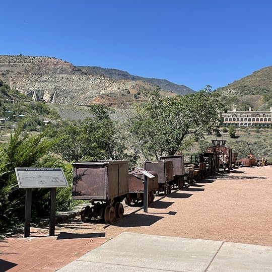
Ore wagons along with drills and other equipment dot the park.

In 1912 Douglas developed the Little Daisy Mine. We walked around the Audrey Shaft (part of the Daisy along with Edith – not sure I’d relish a mine shaft named after me although it probably made her rich).


Audrey plunges 1900 feet down to the copper-bearing rock, some 600 feet below water level requiring pump to remove water and bring in air – the very thought was terrifying. I walked around the industrial ruins trying to imagine standing in the tiny elevator to be lowered so deep in the earth for the start of my shift.

The bonanza ended in 1953 when magnates left due to loss of profits. But what happened to the miners?
One thing for sure: Everything passes with time.
Copyright Judith Works


October 15, 2021
ARIZONA: The Red Rocks of Sedona
Everyone says don’t miss Sedona. They were correct!

We turned off the freeway about two hours north of Phoenix to follow the road to Sedona winding through desert plants surrounded by small yellow butterflies flittering around flowering shrubs.

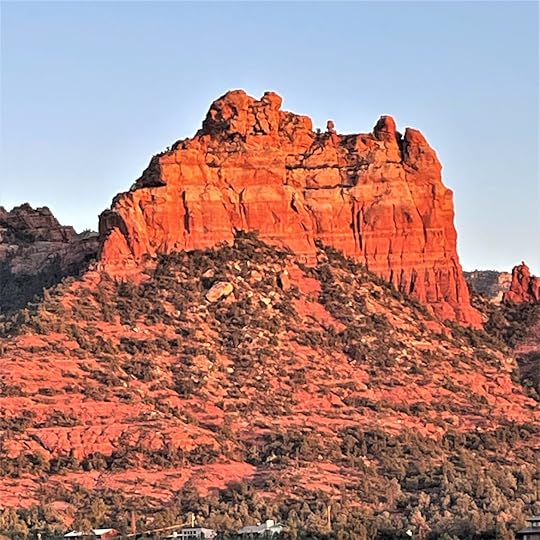
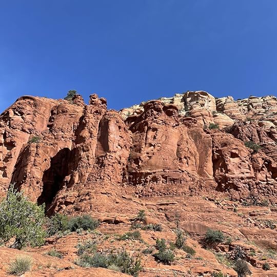
Another few turns brought us to a halt to stare in awe at the magnificent sight of orange and dark red sandstone sculpted into giant spires, plateaus, canyons and massive rock escarpments all constructed by the gods of wind and water over eons. The formations were aptly named The Bell, The Courthouse, etc., on our map, but the human names did not do justice to the giant shapes glowing in the sun.
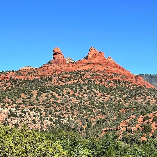
We were fortunate that our hotel overlooked other formations where the colors change with the atmosphere and the position of the sun, some glowing red-gold in the lowering sun, others sinking into dark shade until the next day.
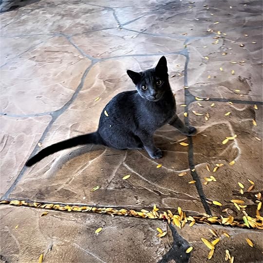
Sedona attracts legions of tourists, many are hikers along with those from Phoenix who want a quick getaway. But the town is also the center of the wellness industry with dozens of businesses catering to those in need of personal fulfillment. Shops sell crystals, tarot reading, lotions, sage for smudging. Establishments for alternative medicine abound, and high-end hotels feature luxurious spas with esoteric treatments. Devotees pray and meditate at a Buddhist stupa seeking spiritual renewal. Ah well, it’s not my thing but I did want to visit one of the famous vortexes where one can feel some sort of energy – either masculine or feminine. Unfortunately, there were so many energy seekers we could never find a place to park so I had to be content with enjoying the spectacular view from our hotel while nursing a glass of wine and watching a kitten play with falling leaves, a low energy occupation but one that did me a world of good before embarking on some retail therapy, another of the town’s specialties.
My husband said he’d always wanted a silver belt buckle. The town had plenty of stores specializing in Western wear. But some of the offerings were too fancy, some too plain, some so big they looked by the belts worn by champion boxers. We sampled shops filled with Native American buckles, bracelets, bolo ties, rings and pendants worked in silver, turquoise, and other stones.
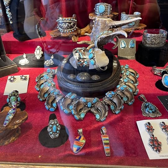
Finally, hubby found the design he wanted in a display case at the Appaloosa Trading Co., the last shop before we quit for the day. The shop owner described how he bought it in Durango, Colorado from a New Mexican artisan years earlier and how he’d only that day brought it out of his safe for display. The Art Deco-inspired buckle was engraved on the reverse with the name “Nuste”. Whoever he is, the object is a work of art. Mission accomplished!

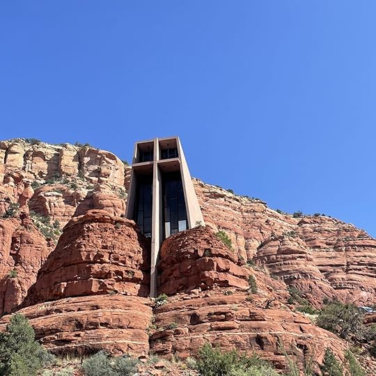
While we weren’t attracted to the endless wellness offerings, we did visit a spectacular site that combined the natural and man-made divine: the Chapel of the Holy Cross. The chapel was commissioned by a local rancher and sculptor Marguerite Staude, who was inspired by the design of the Empire State Building vaulting into the sky during the Depression. She planned to build a church in Budapest, Hungary but the project had to be abandoned due the outbreak of World War II. Instead, she turned to this site, an inspired choice indeed. The chapel was completed in 1956 and has been a magnet for worshippers of all faiths as well as those interested in the architecture where the building seems to spring out of the surrounding red rocks.
The church is on a plateau but overlooking the site is a row of human-seeming natural sculptures – sort of Mount Rushmore – or are they ancient deities of those whose cultures have vanished or saints of our era frozen in stone but still guarding the site?
Who knows, but we did have a spiritual experience.
All photos copyright Judith Works
August 24, 2021
ORCAS ISLAND – A Rural Idyll

Anacortes on the north coast of Washington State and our stop before moving on to Orcas. The town was formerly somewhat of a backwater but has recently become a destination for water-oriented retirees attracted to small-town living, gorgeous views of saltwater with passing cargo ships, pleasure craft and fishing boats, and easy access to the San Juan Islands.
We were amused at the many cutouts of historical figures and current workers that decorate buildings as we drove toward the ferry dock.


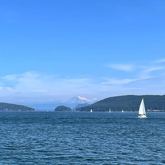
The weather was sunny and cool when we boarded the ferry for Orcas Island, one of the four San Juan Islands served by the Washington State Ferry System out of dozens that are part of an archipelago reaching all the way from south Puget Sound up through the area around the Straight of Juan de Fuca through the Canadian Gulf Islands and toward Alaska.
We were enveloped in blue on the one-hour plus trip – blue water and blue sky. The ferry was full of youth groups with their backpacks, cyclists and canoeists along with those of us heading for campgrounds or local lodging.


Yachts and sailboats passed as we followed the route through islands and islets to reach Orcas – named after a Viceroy of Mexico. Many of the islands in this chain have Spanish names due to their explorations in the early 1790s.

The main town is Eastsound, home of a well-known summer concert series, at least pre-Covid, was bustling with tourists enjoying the boutiques, art galleries with water views, cafes and watering holes. Fun fact: Oprah Winfrey and her partner own many of the buildings that comprise the town center although she recently sold her estate in the nearby hamlet of Olga for $14 million.


Our lodging was the quirky Craftsman-style Kangaroo House, built as a hotel in 1907. After it closed in the Depression it became the home of a sea captain in the 1930s. He returned from one voyage to Australia with a kangaroo. Josie the ’roo hopped around the neighborhood for about ten years until a motorist reported to the sheriff that he’d accidentally hit a very strange deer one night. Now the house serves as the oldest continuingly running b&b on the islands. One attraction is the divine 3-course breakfasts. One morning we feasted on fresh fruit, with a main course of “breakfast risotto” topped with a farm-fresh egg and local greens, followed by mini pecan muffins for dessert.

We enjoyed the farm stands with lavender and fruit, strolling along the quiet yacht harbors that dot the sheltered coves, and poking around resorts ranging from simple 1940s cabins and luxury digs like the beautiful Rosario Resort begun as a home for a shipbuilder and Seattle mayor Robert Moran in 1909 and now listed on the National Register of Historic Places. We walked the trails around Moran State Park made up of land donated by its namesake. Especially beautiful is the view from the summit of the 2400-foot-high Mount Constitution where we could see the Cascades, Vancouver Island, other islands of the archipelago laid out before us.


Our last stop before heading for the home-bound ferry was the labyrinth on the grounds of the lovely Emmanuel Episcopal Church built in 1885. To walk a labyrinth is to know peace, to free oneself of daily cares, to commune with the spiritual life. To be refreshed. We were indeed.

Some websites:
All photos copyright Judith Works
June 11, 2021
HAWAII -Of Gods & Men

A barefoot man wearing a loincloth and a traditional short cape made of ti leaves walked by me as if deep in thought. When I turned to watch him, I could see his black hair cut high on the sides and left long on top to fall around his shoulders. Without looking to right or left he strode away from the Great Wall defining the Pu’uhonua, Place of Refuge, during ancient Hawaiian times.

He projected power and I could not help but wonder if he was a chief or priest. and perhaps the descendant of those chiefs of old who wore magnificent yellow and red capes and headdresses of bright bird feathers.

The Pu’uhonua is half of the National Historical Park on the Big Island. Established in 1961 the area comprises the Place of Refuge and Royal Grounds together marking a place of spirit, power and safety. From the time of Hawaiians’ arrival from Tahiti in the 900s until 1819, the year King Kamehameha died and the concept of kapu began to be abolished, the area was the refuge for those who broke these laws – a woman eating with a man, catching fish out of season, or casting his shadow on royalty. The unfortunate soul who committed one of these crimes had to flee on foot to the coast and attempt to swim to this low-lying peninsula of rough lava open to the sea. If he survived the ordeal, he could be absolved by a priest. The area had an additional function: serving as a sanctuary for children, elders and noncombatants during time of war as well as defeated warriors who would wait until the end before returning home.

Marking the divide between the refuge and the Royal Grounds is the National Park’s most famous structure, the Hale o Keawe, probably first erected around 1700 although renewed many times due to the weather. This thatched wooden building is the royal mausoleum housing the bones of 23 royal chiefs, ali’i. Wooden images surrounding the mausoleum are Hawaiian gods.

The Royal Grounds were a place of ceremony, negotiations, and pleasure with fresh fish from the royal fishponds in the complex, board games played with black and white pebbles, and sledding down a lava ramp slicked with nut oil, leaves and grass. It must have been fun.
The National Park is unusual in that while the NPS maintains the physical structures, Native Hawaiians perpetuate ancestral traditions as caretakers and cultural practitioners. A perfect example, and a few minutes I will never forget, arose as I returned to the park entrance: I could hear a mallet tapping on wood and paused to see a young man in a loincloth sitting cross-legged on the ground under the shade of a thatched hut used by native artisans. As I watched him work on a sculpture another young man wearing the standard Hawaiian outfit of tee shirt, shorts and flipflops, and accompanied by two young women, walked up to the hut’s entrance. He began to ever-so-softly chant melodic words. Was it a song of praise, a hymn to the sun, one of greeting? I don’t know, but the artisan responded with a similar ethereal chant before rising to embrace his visitor.
I was an unwitting interloper standing on soft sand amid rustling palms experiencing a tiny window into an ancient and complex culture that continues to exist despite the inroads of the subsequent arrivals since American sugar barons engineered the takeover of the islands in 1893. I moved on to avoid intruding further into this fleeting moment of ancient Hawaii.


All photos copyright Judith Works
April 16, 2021
HAWAII -HILO & RAIN
Hilo isn’t exactly what one typically pictures of Hawaii – white sand beaches, luxury hotels, blue sky. Instead, it’s truly tropical with rain, clearing, and more rain – ten feet a year on average. BUT, it has food, a foodie’s idea of heaven along with parks hosting enormous banyan trees and bamboo. On the Island of Hawaii (known as The Big Island) it’s a world away from the condos and golf courses that dot the dry, Kona Coast, side.
As soon as we crossed the pass between Mauna Kea and Mauna Loa volcanoes it began to rain. And rain. Buckets of rain because we’d managed to pick a date to travel when a severe tropical storm engulfed the state with the area around Hilo getting about four feet a day.

Our hotel with balcony over the water presented a dismal sight, but we weren’t there for suntan. We were there to look at the old buildings and eat.
First stop on Saturday morning was the famous farmer’s market. Because of Covid it wasn’t what it would normally be with a hundred booths but it was still interesting with flowers, veggies and fruit. One vendor had his homemade banana bread which was perfect for breakfast – sweet and moist made from real bananas, grown in the vendor’s garden not a commercial operation in another country.


The KTA grocery store where we stopped to get umbrellas and survey the myriad food offerings coming from every corner of the south and east Pacific Rim was a revelation: Spam, which has become part of the culture of Hawaii and other south sea islands, dozens of varieties of noodles, sauces, dried bonito tuna flakes, pickled vegetables, fruit, and spices from Pacific Rim countries. One spice was especially intriguing: Li Hung Mui which is made from dried plum, salt, and licorice. Hawaiians love it on everything from popcorn to pineapple.

A nearby stand introduced us to another Hawaiian specialty: shave ice – which is tiny bits of ice topped with luscious chocolate, whipped cream, or fruit.


There are plenty of eating spots in the town but the Hilo Bay Café became our favorite dine-out spot. Although they have mainland standards like fried chicken, I had sushi rolls with tobiko – delicate flying fish roe – in honor of my favorite fish that I’ve so often watched leap across blue tropical waters. For those who like a typical a Hawaiian dish – poke – there was one made with spicy raw ahi tuna. On another meal I enjoyed crab cakes and a fresh catch of the day – the fishing dock was close by.

Needing to satisfy our sweet tooths, we ordered from the famous Two Ladies Kitchen, a tiny mom and pop shop in an old building but so popular people line up around the block to pick up their ordered of Japanese treats. We chose Fresh Strawberry Mochi, their most famous sweet. It’s made with a short grain glutinous rice pounded into a stretchy paste and in this case containing a layer of sweet bean paste with a perfect strawberry nestled inside. So rich two practically made a meal.


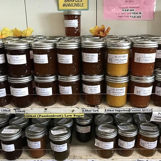
Small specialty farms are thriving on the island after the big sugar and pineapple plantations moved elsewhere. Many offer farm tours: coffee, vanilla, avocados, macadamia nuts, and tea. And, of course, specialty shops like Mr. Ed’s Tropical Preserves in a tiny town north of Hilo offer other temptations. If you have a hankering for Passion-Chocolate or Ginger-Papaya Jam or Kumquat Marmalade, or one of the dozens of others, this is your place.
We saved the best for last: a tour and tasting at the Hamakua Chocolate Farm, a paradise of tropical plants and trees.

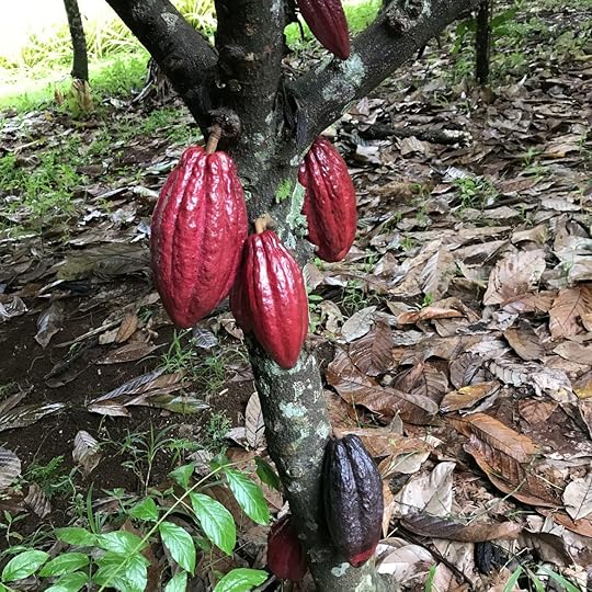
The tour goes rain or shine and while we got off to a great start in the cacao grove marveling at the strange and colorful cacao pods, a Biblical deluge began and we gave up at the treehouse where from a vantage point 65 feet in the air we could see the botanic collection of exotic fruit trees, flowers, and a rushing stream where the others on the tour continued.

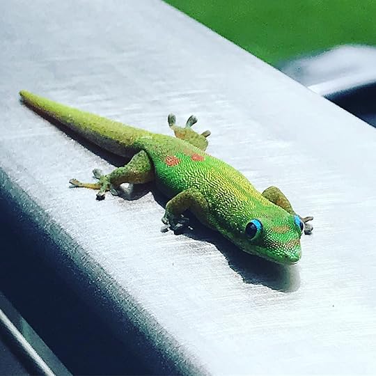
We waited under the covered patio for the them to return by watching a gecko play hide and seek in a bowl of cacao pods and displaying him or herself in contrast to the ethereal colors of the Blue Jade flowers on the table.

The others on the tour returned drenched but happy and we sat around the table to learn how chocolate is made from the cacao pods before a tasting of the intriguing varieties of chocolate bars handmade in the small batch production facilities. The problem was that we wanted all of them. We came away with a selection that included Black Pepper and Chai Spice which has cinnamon, ginger, clove, cardamom, nutmeg, and allspice from the farm; Hawaiian Hot Chile Pepper; and most interesting a couple of bars flavored with Li Hung Mui. Move over Belgian and Swiss chocolates!!!

For those who have the time, the farm offers two luxurious vacation rental rooms with views of sunrise over the Pacific and of course a deep dive into chocolate production. If you can’t get there you can enjoy photos of chocolate and tropical flowers by going to HamakuaDan on Instagram.
Too soon, it was time to move to our next destination, taking a drive around the top of the island to the dry side and the golf courses, condos, and hotels of blue-skied Waikoloa. And enjoy our chocolates.
If you are thinking of visiting the Hamakua Coast and tropical Hilo, here are several websites you might want to check out before you travel:
https://www.facebook.com/twoladieskitchenorginal
Aloha!
March 3, 2021
SAN JUAN ISLAND

The weather report was bad but a winter getaway called to celebrate our anniversary — a week early because everything was booked for our day which is Valentine’s Day. We decided to stay on the largest island in the town of Friday Harbor, the county seat of San Juan County made up of an archipelago of four lightly populated islands and a spray of others that adjoin those in Canada that continue up the Inside Passage. The hotel, Friday Harbor House, had a fireplace and we had books and a bottle of wine. Best of all our room overlooked the Washington State Ferry dock. We planned to settle in to watch rain, trading cabin fever at home for cabin fever on an island.

The forecaster was wrong. The morning came with more sun and, instead of sitting on our bottoms, we headed out to explore the island, one so peaceful and safety conscious even the animals wear masks.

Roche Harbor was the first destination. Now a luxury development with visitors arriving in yachts and seaplanes, the hotel built in 1883 as a home for the John McMillian family still welcomes visitors. The property was first quarried by the British to exploit limestone, a sedimentary rock composed mainly of skeletal fragments of marine organisms. It is processed for use in road surfaces and to manufacture concrete, mortar, glass and iron; and to neutralize acidity in soil used for agriculture. McMillian industrialized the site which operated from 1886 – 1956 when the site was sold for a resort. Lime kilns are still part of the scene.

Nearby is an outdoor sculpture garden which hosts an eclectic display of art. Very eclectic to say the least: a driftwood kangaroo placed near Northwest Native Art just one example.


But the major attraction of the island is the San Juan Island National Historical Park, the two sections, a monument to the possibility of peaceful dispute settlements.
In 1846 the Oregon Treaty established the 49th parallel as the boundary between Canada and the U.S. While both sides agreed that all of Vancouver Island would remain British, the treaty did not specify which channel the boundary should follow between the Strait of Georgia and the Strait of Juan de Fuca, resulting in a boundary dispute. The escalating dispute led to the Pig War in 1859 when an American settler shot a trespassing prize boar owned by an employee of the Hudson Bay Company leading to a protracted diplomatic confrontation. It continued until the issue was weirdly placed in the hands of Kaiser Wilhelm of Germany for arbitration in 1871. The border, through Haro Strait, was finally established in 1872. History does not reveal who got the sausage or bacon.
Here’s a short video that the describes the conflict and peaceful resolution. https://vimeo.com/103012997
As a side note: Two of the American military men involved later became renown for other reasons: Henry Roberts, later a general in the Civil War established Roberts Rules of Order, and George Pickett, Confederate leader of the deadly and decisive Pickett’s Charge at Gettysburg.

We began at English Camp where the British Flag is still raised and lowered every day. Lucky were the English who were quartered here with a sheltered harbor, an enlisted men’s vegetable garden bounded with clipped boxwood, gorgeous old trees dotting the camp. The British Government not far away on Vancouver Island took care of their men.


Next was a stop at the beautiful Lime Kiln State Park where we stopped to walk to the lighthouse and watch the container ships passing between our island and Vancouver Island through the Strait of Juan de Fuca. Whales often are seen here but we weren’t lucky.

The American Camp and Cattle Point (location of a Hudson Bay Company Sheep Farm and 1935 lighthouse) are on the southeastern tip of the island and a complete contrast to the English Camp. The area is directly facing the Salish Sea and Strait where ocean waves roll in with great force carrying driftwood, and the winds bend the grass of the prairie that covers most of the site. Hikers with kids and dogs blew along the trails as the wind whistled. We could not see any structures from the actual camp except a large earthen redoubt.


It showered the evening before our departure, the first we’d seen, and in a hopeful sign, a glorious rainbow appeared over the ferry as if to signal a happy year ahead. A few days later the Pacific Northwest winter stormed back with a blizzard!

All photos copyright Judith Works
January 21, 2021
ROLL ON COLUMBIA: ASTORIA AND THE MOUTH OF THE COLUMBIA RIVER

Woody Guthrie’s famous song written in 1941 to extoll the virtues of dam building on the Columbia River and its tributaries is not the subject of this story although the effect of all that damn dam building (some eighty) is one of the causes of the demise of the salmon fishing and canning industry that once powered the booming economy of historic Astoria Oregon.

The small city sits a few miles from the mouth of the Columbia where the river empties into the Pacific Ocean in a roiling combination of swift and silty fresh water fighting the ocean tides and storms. The result is treacherous ever-shifting sandbars and forty-foot waves. Some two hundred large ships have been recorded as sunk and many lives lost in this area rightly called the graveyard of the Pacific. Some years ago, my coworker and her husband drowned on an ill-fated fishing expedition when their small boat overturned in the heaving swells.
The Lewis & Clark expedition spent the winter of 1805 – 06 at a nearby spot they named Fort Clatsop before they began their long return trek to St. Louis to report to President Jefferson who commissioned them to find a route to open up the far West. The weather was rotten. Clark summed up the situation: “O! How disagreeable is our Situation dureing this dreadful weather.”
The town itself began in 1811 as a fur trading outpost backed by John Jacob Astor under British Control until 1846 when the area became firmly under US control and settlers coming over the Oregon Trail came to exploit fishing, farming and timbering no matter what the weather —67 inches of rain or more plus windstorms blowing in from the Pacific every year.
Bursting with immigrants, most of whom were Swedish, Finnish, or Chinese, the town was a Wild West in the glory days of canneries and lumber mills fed by endless fish and logs. Now it is more famous for tourism and the canneries are memorialized on the downtown trash containers.

The city hosts an annual poetry festival for Fisher Poets, microbreweries abound and the occasional cruise ship stops by.

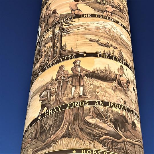
The most prominent attraction is the Astoria Column, a 125-foot-high tower inaugurated in 1926 to highlight the early history of the area from Native American life to the coming of the railroad in 1893. The tower is interesting artistically even if not always correct (the native peoples didn’t erect totem poles and Lewis & Clark arrived in boats not dugouts). The setting, the highest hill in the city, is incomparable presiding over the city, the river, and the countryside especially on a sunny day.

The painter, Attilio Pusterla, was an Italian American who used the same spiral story-telling method as that carved on Trajan’s column in Rome, although he used an ancient technique called sgraffito where a lighter color of plaster or other substance is applied over a darker one and then the design is incised. The result on the Column is the unwinding of a story in mellow shades of beige and brown that harmonize with the setting.
The Columbia River Maritime Museum surely is in the first rank of American natural history museums. Room after room tell the story of the mouth of the 1200-mile great river from maps and charts of the earliest explorers, crossing the bar, the fishing and canning industry, fishing vessels, and the Coast Guard’s heroic rescue operations.

An old ship once used as a lighthouse is anchored nearby.

The freighters slide by, some having passed successfully over the treacherous bar to go upriver, and others ploughing ahead as a pilot ship speeds toward them so the pilot can jump onto the dangling rope ladder to ascend to the bridge and guide the ship toward the ocean and its onward journey.

We crossed the river on the four-mile-long bridge opened in 1966 to mark the final connection for the Pacific Coast Highway running from Olympia, WA to Los Angeles. Our goal was Cape Disappointment on the north side of the river where there are spectacular views and two lighthouses. Cape Disappointment was already named by the time Lewis & Clark reached the site in November 1805. The Spanish explorer Bruno Heceta, named it “Bahia de La Asuncion,” or Bay of the Assumption in 1775. Then in 1788, British trader John Meares named it “Cape Disappointment” when he mistakenly believed that the mouth of the Columbia River was only a bay. He missed the riches of the river.
The lighthouse, looking weathered, sits just inside the mouth of the river.

To access it we hiked a short but steep and rough 1.2 miles puffing our way past the Coast Guard station famous for daring rescues in perilous storm conditions.

The lighthouse sits near a mysterious sign, one that I assume is for navigation although I’ve not been able to determine the meaning.

The second lighthouse is North Head, neat and tidy and reachable by a paved path. On this glorious sunny day, it was hard to imagine desperate sailors trying to pick it out as waves and wind lashed the ship and they feared for their lives. We only had to walk to our car.

If you are interested in the history of this area, I recommend Karl Marentes’ saga Deep River about logging, fishing, and labor unrest roiling Astoria and the lands just north of the river in the early 20th Century.
All photos copyright Judith Works except that of the salmon cannery public domain from NOAA
December 5, 2020
A WINTER WEEKEND ON WHIDBEY ISLAND
Tired, oh so tired by our semi-lockdown due to Covid, we decided to take a quick getaway to an island we can see from our living room. An island with almost no virus cases. Feeling secure, we joined the line at the ferry dock in the nearby town of Mukilteo for the twenty-minute cruise to the tiny town of Clinton on the south end of Whidbey Island.

Named for Joseph Whidbey, Master of HMS Discovery, who along with expedition leader Captain George Vancouver, explored the island in 1792. They weren’t the first to arrive as the island was long occupied by the Skagit, Swinomish and other tribes who arrived thousands of years earlier, subsisting on the abundant salmon, shellfish, deer, and waterfowl. The tribes suffered the same fate as elsewhere when settlers moved in to take advantage of the timber, fishing, and farming opportunities.
The lumber mills are gone but for an occasional remnant like an old “wig-wam” sawdust burner.

Our first stop was in the lovely little town of Langley on the Saratoga Passage, a narrow strait good for whale watching.
The town is home to art galleries, B&Bs and our favorite shop, the delightfully named Music for the Eyes. We never miss a stop whenever we are on the island and have several times come home with irresistible carpets to warm our toes or to just enjoy looking at the design and dream of faraway places. Not a typical rug store, the shop has an astounding selection of carpets, clothing and other art from Turkey, the Caucus, and the “stans,’ where the owners, former State Department staff, worked. This time I fell in love with a linen wall hanging embroidered with wool designs. It was formally a room divider or wall decoration in a yurt in Kazakhstan and sadly too big for our home.


Coupeville, founded in 1854, was just a few miles further north. Like Langley, the main street is lined with eateries, often featuring the local and delicious Penn Cove mussels, along with galleries and B&Bs.

The town has the distinction of being part of Ebey’s Landing National Historical Reserve established “to preserve and protect a rural community which provides an unbroken historic record from 19th century exploration and settlement in Puget Sound to the present time.” Unusually, the area now encompasses State parks, farms, private homes, woodland, prairies, beaches, trails, and an underwater marine park.

The historic farmstead is a few miles from the town center and overlooks the western coast.

We walked a wooded trail starting from the Jacob Ebey House, peering in the window of the small dwelling and the block house built for protection from marauding tribes canoeing down from the Canadian Coast. Ebey was killed in one of the raids and he now rests in the nearby and cheerfully named Sunnyside Cemetery along with many other early settlers.

A white marble monument in the cemetery erected in honor of someone named A.W. Bush, who died in 1933, caught my eye because of the little marker announced it as the resting place of a suffragette.

The island is long, narrow and twisty and lined with bays, beaches and headlands. It also hosts my favorite Pacific Northwest tree, Madrona, with its glowing chartreuse and ochre bark. The trees often lean over a bluff as if to look at the inland sea.


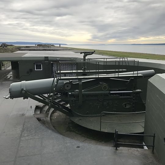
The Western side of the island marks the entrance to Puget Sound through the narrow Admiralty Inlet where ships gain access to the cities of Seattle and Tacoma, as well as Everett and Bremerton – both with large Navy bases. Military minds recognized the strategic importance of the area early on. Three forts known as The Triangle of Fire were built from 1856 to 1897 to guard the inner Sound. None of the forts every fired a shot in anger and all three are now state parks where visitors can wander, picnic, and enjoy festivals.
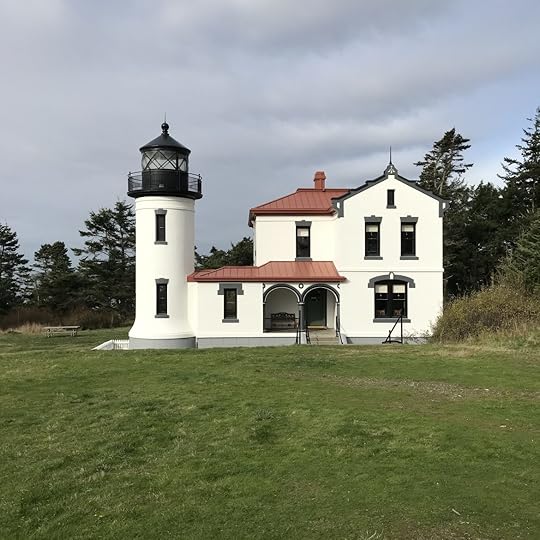
For those who are interested in military history, Fort Casey, one of the three fortresses, features tunnels, speaking tubes, shot and powder rooms and guns mounted on retractable swiveling arms. Husband loved poking around the examples of earlier military might; I walked to the lighthouse originally built in 1859 and replaced in 1903, and watched the deer, one of which, a doe, was leaping and bounding in a frenzy of excitement: Up a hill, pirouette, leap, leap, then down the hill. It looked like fun but the sun was waning and it was time to head toward our temporary home.
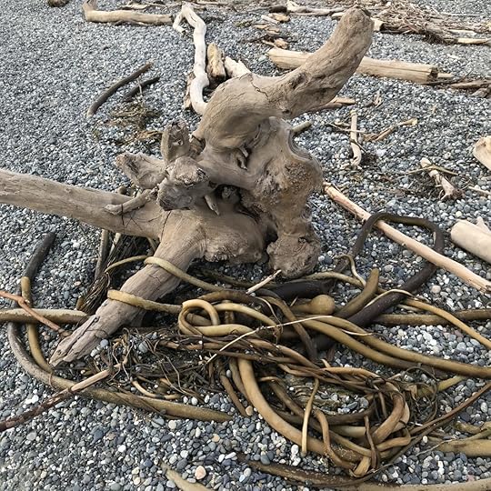
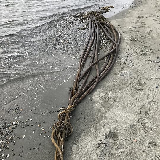
Not wanting to be close to anyone else, we’d booked a VBRO (number 646795) – a lovely house with a great view of the water looking west toward the Kitsap Peninsula and the sunset. The garden must be beautiful in the summer because it is landscaped with many dozens of lavender shrubs. The house comes with beach privileges so we wandered down to the now-deserted area to walk along the shore. The evening in front of the fireplace with a glass of wine was time for imagining stories about driftwood ogres and mermaids who braid long strands of kelp for our pleasure.
All photos copyright Judith Works
October 31, 2020
Bog Boots & Oysters – An Autumn getaway to the Long Beach Peninsula

I’ve always wanted to see the cranberry harvest on the Washington Coast. So, when it looked like the weather gods would smile for a few days on the usually rainy Long Beach Peninsula in the far southwest corner of the state, we decided to drive four hours from our home. In no hurry, we took secondary roads, more scenic than the freeway. They wind through logging country where we dodged the loaded trucks whipping down the road toward mills to add to the piles of logs (called cold decks around here) waiting to be turned into lumber.
We made a quick lunch stop in Raymond (City motto: Everybody Loves Raymond) on the Willapa River. The logging and fishing town follows the economics of the timber and fishing industries with its many fluctuations related to the economy and environmentalism. Its population has actually declined over the last few years. To bring in tourists the city has erected delightful steel cutouts of local people and animals – loggers and elk line the road. The hamburger stop was typical of tiny towns scattered throughout the West: a juke box, stage for weekend music, and pinned dollar bills on the walls between the beer posters. And good hearty food.

The sheltered waters of Willapa Bay came into view west of the city. We followed the coastal road (Highway 101) along the water’s edge with Angus cattle grazing in fields, seabirds resting on the tranquil water, and poles marking oyster beds.
Late afternoon, we turned right to access the Peninsula, supposedly the longest beach in the US at 28 miles. The area has been a beacon for visitors coming to enjoy summer fun and other activities like clamming for well over a hundred years. It was so popular that a narrow-gauge rail line took a Pullman coach up and down the peninsula from 1889 – 1930.

Our lodging destination was the Shelburne Hotel in Sea Vue. Built in 1896. It’s been a fixture ever since. To say the least, it’s quirky. You need to be nimble to get in the showers because you must step into the deep bathtubs, and with the exception of one window in each of the two units we stayed in, they are painted shut. The working window has to be propped up with a block of wood. On the other hand, the food in the hotel’s pub was absolutely fabulous. The lobby is cozy and was decorated for Halloween and I enjoyed my morning coffee in front of the fireplace while chatting with a young Irish woman who on a year-long internship in hotel management. She told me she loved the experience.

After stuffing ourselves with their marvel of a breakfast (served on a large board), we headed out to enjoy the sun and see the sights. First stop was the cranberry harvest. Most cranberries are grown in Wisconsin and Massachusetts but the first vines were planted here in peaty soil in 1872. To harvest the field is flooded and a machine that looks like a vacuum cleaner shakes them loose and scoops them up. But there are several bogs on the peninsula as well as an agricultural experiment station.

We watched the harvest – a colorful sight with red berries and blue sky. Of course there was a gift shop with jam, jelly, sauce and all the other products one associates with the berry like flavored snacks, cookbooks, and sweatshirts. A small museum gave the history of the industry. It must have been back breaking with workers in their bog boots bending to harvest the berries before water harvesting and industrialization took over.


Another day we drove up the peninsula to Nahcotta where piles of pearl gray and white shells, some so tall they looked as if they were the pyramids from a distance. Further on is the historic town of Oysterville, where the lovely homes were decorated for fall as if they were in a design magazine.


The tip of the peninsula is reserved for one of the three sections of the Willapa National Wildlife Refuge established in 1937 by Roosevelt to protect migrating and wintering populations of brant, other waterfowl, and shorebirds. It also serves as home for Roosevelt Elk as well as bear and river otters., The mud flats teem with shellfish; Great blue herons keep watch, waiting for a meal of fish or frog.
After a walk on the trails it was time to head back to the hotel, hoping for oysters whether grilled, raw, baked, in chowder, or fried.

All photos copyright Judith Works except photo of Raymond sign courtesy City of Raymond.
September 28, 2020
OSLO – WAR AND REMBRANCE
After experiencing the wild exuberance of the Vigeland Sculpture complex, the Oslo City Hall is a model of sobriety with its red-brick exterior and rational layout, entrance courtyard with fountain and carvings from Norse myths, and long central hall flanked by two towers. Instead of naked writhing people, the artwork is reflective of the Norwegian character based on foundation myths and history.


While there are oil paintings and ceramic plaques, such as these honoring women,


much of the artwork in the interior of the grand building is in the form of fresco, a medium I particularly like.


The far end of the Great Hall, the site of the annual Nobel Peace Prize ceremony, is a history of Oslo.

But by far the frescoes on one wall are the most moving. They are titled “The Occupation Frieze” done by Alf Rolfsen to remind and commemorate the Nazi Occupation of Norway from 1940 to 1945. They comprise the history of this bleak period from fear, terror, resistance, and finally freedom. And I found them unforgettable and a warning to us all that freedom is not guaranteed.


***
Another monument to war and peace is the Akershus Fortress located on a hill abutting the Oslo waterfront not far from the city hall. The central part is a medieval castle founded in the late 1200s, modernized in the 1500s. Numerous other buildings make up the complex: dark passages, stables, fortified gates, guardhouses and a drawbridge. The Powder Magazine Tower erected in 1755, served as Death Row for Norwegian Resistance fighters and nearby is their execution ground.


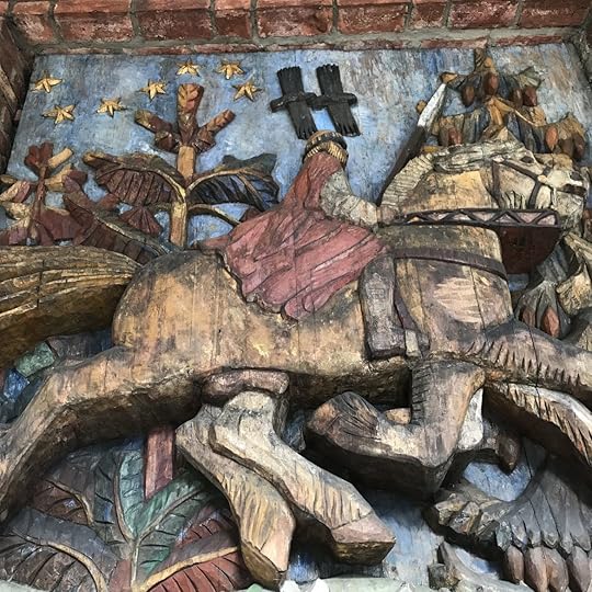
A museum dedicated to the Resistance occupies a small building dating from 1691. The display is chronological, beginning with April 9, 1940, when Norway was unexpectedly attacked and a coup d’état resulted in a government run by the infamous Quisling and the Norwegian Nazi Party. The event is memorialized by a brutal sculpture of German Mauser Rifles in the shape of a swastika.

The exhibit continues with photographs of the war years marked by hardship and defiance with the final triumph of freedom regained.


The bookshop has narratives and memoirs in both Norwegian and English. I bought The Winter Fortress by Neal Bascomb, recounting the amazing story of the young men who sabotaged a power plant to foil Hitler’s aspiration to build an Atomic Bomb.
The fortress now hosts cultural events. I watched children enjoying a comedy and hoped they would all be able to live their lives without the specter of hunger and war hanging over them.

All photos copyright Judith Works