Judith Works's Blog
July 13, 2023
Madam Pele’s Handiwork
Some days ago I marveled at the photos of the goddess Pele’s display of power in the caldera of the Kilauea Volcano in Hawai’i Volcanoes National Park. The park guide tells visitors about how Pele traveled many leagues from the northern-most islands guided by her favorite brother Kamohoali‘i who was also a guardian shark. Having traveled for many miles from Kahiki in search of a suitable home for her fire and family, Pele finally settled in the crater of Halema‘uma‘u at the summit of Kilauea Volcano.
https://www.usgs.gov/media/videos/kilauea-summit-eruption-halemaumau-june-7-2023-0
The guide tells us that Pele personifies fire and volcanism in all its forms and the landscape is her handiwork. The poetic name for her is Ka wahine ‘ai honua, the woman who devours the earth. But as she devours some part of the island of Hawai’i, she builds on others as she sends streams of molten lava flowing down the slopes of the Big Island, destroying everything in its path. The land trembles and the sky is afire with a crimson glow as her molten body moves across the land. Those present whisper in awe, “‘Ae, ‘aia la o Pele, There is Pele”.
Kilauea is much smaller than Mauna Kea and Mauna Loa, that all together make up the Big Island – the Island of Hawai’i. Mauna Loa stands 56,000 feet above the sea floor and 13,677 feet above sea level, and is the Earth’s most massive mountain. It’s the site of a weather observatory and often snow-capped, quite a sight from tropical Hilo. In 2022 an eruption caused lava to flow toward the main highway between Hilo and Kona (and the main airport), stopping about a mile from the road.

Kilauea is almost constantly active, and lucky for us, easily accessible, only a 40-minute drive from Hilo, our favorite Hawaiian destination. On our last visit the weather was gorgeous with blue, blue sky as we ascended to near four thousand feet from sea level. Hilo was soon left behind in favor of small farms before the entrance to the park.
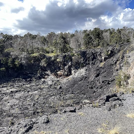
A short walk from the visitors’ center and we came to the edge of the giant caldera some two and a half miles wide two miles long below us. I was overcome with awe at the spectacle – a sea of hardened black lava around the edges of a cliff and the floor of the caldera with a center of occasionally fiery bubbling burping liquid lava toward one side.

The fire goddess was resting so there were no gushers or geysers but it was still terrifying. A lone bird (an omen from Pele?) winged over the immense barren circle, easily described as the mouth of Hell. I was struck with wonder at the power of nature, the power to build and destroy, the power to produce Hawai’i.
The park has many hiking trails but we were interested in driving the Chain of Craters Road leading from the Visitor’s Center back down to the sea near the Holei Sea Arch where the road now ends. It was truncated by lava flows from 2004 to 2010 so that it is no longer possible to drive to towns and beaches beyond in a loop leading back to Hilo. At the start of the road we entered a jungle with trees including palms overhanging the roadway and giant ferns spreading over the ground – a tropical tunnel.


There are about fifteen small craters near the roadway, some steaming, others long ago quiet, some barren and others filled with vegetation.
The vegetation disappeared as we descended and became a wasteland of sharp lava, with only the most determined small tree like the red-flowered Ohi’a lehua bravely sticking up from a fissure where dust had blown in or the lava has disintegrated enough to sustain life.

At the end of the 19-mile road we reached the edge of the sea. A short walk through a boulder-strewn area led us to a cliff-top overlook to view the immensity of the Pacific Ocean. Surf crashed into the arch far below.
The boulders were made of a ropy lava where the heave and flow of liquid rock left waves, cracks, and what looked like thumb prints perhaps of Pele.

But here again plant life fought back. I marveled at the ferns that have taken root in crannies and cracks.

I hoped Madame Pele approved of the natural leis hung on the rocks.
All photographs except video from USGS are copyright Judith Works


April 15, 2023
The Pleasure of Old Travel Guides – Part II
Guides to Italian inns and b&bs, the red Michelin with recommended restaurants and hotels in cities and larger towns, guides to specific provinces like Umbria or the Veneto, and some for wineries fill a couple of my bookshelves. But there are three that I keep separate, not for their usefulness, but for their historical interest. I love to thumb through them for insights into the past: one from the early 1900s, one from the 1950s, and the third a guide to one of Italy’s colonial possessions – that in East Africa.

Baedeker’s guides were a vital part of tourists’ baggage in the late 1800s early 1900s. Lucy Honeychurch missed hers when she was lost in Florence’s Santa Croce cathedral. Without it she became overwhelmed by the glories of the Renaissance in E.M. Forster’s delightful novel Room With a View. The book, published in 1908, is a classic as is the 1985 film starring Helena Bonham Carter.
I’d like to think Lucy and her traveling companion used my copy of the Baedeker which centers on Rome as they continued their tour of Italy. Published in 1904, it’s already the 14th edition, a testament to the craze for travel to Italy for Brits and Americans.

Like all guides it’s full of history, timelines and advice such as “Trattoria are chiefly frequented by Italians and gentlemen traveling alone, but those of a better class may be visited by ladies also.” Regarding health, it warns that malaria can be contracted in areas beyond the Vatican and near Saint Paul Without the Walls. Travelers further outside Rome must ensure they are home before sunset to avoid the malaria-carrying mosquitoes. Summer visitors are reminded that only dogs and English walk in the sun!
Besides hotels, some of which are still in business, there are addresses for parasol vendors, upholsters, photographers, art studios, sick nurses, baths, and lieux d’aisance. I had to look that up – it means public toilets for the prudish tourist. (Delicate speech for “going to the loo”?
But what is truly fascinating are the beautiful maps and descriptions of the Palatine Hill, Colosseum and Forums along with a diorama (with so many fold-out pages I could only photograph a few) as the rooftops of Rome were at the time. The one below is of the Aventine Hill.

Much is the same but much is different as archeologists continue to explore and dig up new treasures seemingly weekly. It’s hard to believe that the Forum was known as the “Campo Vaccino,” or “cattle field” and was essentially an overgrown, neglected field and wasn’t fully excavated until around the time of this guide.

The other guide is the 1959 first English Edition of the Michelin Guide to Italy that someone bought in Cannes, France. Along with history and the still-used green cover and star ratings for sights not to be missed, this guide seeks to help the possibly bewildered British tourist with helpful information that the Italian is “dark-eyed, gesticulating, nimble and passionate, all movement and fantasy.” Also, the town square is a good place to watch their behavior except in the South where it’s best not to look anyone in the eye.

Other advice includes the admonition that bikinis should only be worn at the smartest resorts, to use your horn liberally when driving, and my favorite, don’t chop up your spaghetti. Instead, try to wind it on a fork while praying that it doesn’t fall into the sauce.
The third guide isn’t one for Italy but rather for Ethiopia (along with Eritrea and Somalia), a country Mussolini invaded in an effort to expand his short-lived colonial empire. The book, Guide to Italian East Africa, was published by the Italian Tourist Association in 1938, year XVI of Mussolini’s dictatorship. A proclamation on the first page states the King of Italy was now the Emperor of Ethiopia. The 490,000 copies printed were free as if the government expected thousands of tourists to catch a boat for a holiday in the colonies. In reality, Mussolini’s invasion of 1935 had settled into a guerrilla war.

The guide, with the fascist eagle on the cover, is 622 pages of fine print with description of sites and history along with finely-detailed maps. Major streets and roads were renamed in honor of Mussolini, the King and Queen along with other officials. I know now that Axum was occupied on 14 October 1935 and 87 Italians lived there. But surely few tourists actually wandered in the hinterlands with their yellow guide in hand.

(For a good read about this period and the guerrilla war, I recommend The Shadow King by Maaza Mengiste. It focuses on women’s role in the fight against the occupiers.)
The reason I snatched up the guide at an antiquarian book fair in Seattle (how did it get there I wonder?) is that I worked for Food & Agriculture Organization of the United Nations in Rome at one time. The building, across from the Circus Maximus, was formerly the administrative headquarters of the Italian Empire and there was an obelisk looted from the holy city of Axum on the grounds. (That obelisk is important enough to have its own Wikipedia page.) I saw it every day when arriving at work and it served as a meeting point for workers and tourists alike. It was finally returned to Ethiopia in 2005.

All tourism bureaus can be accused of promotional overreach or suffer from the prejudices of their authors and the times. But that’s why old guidebooks are so interesting. On my next trip to Rome, I’ll be careful with eating my spaghetti while I look for a nimble and passionate Italian even though the obelisk is gone!
All photographs are copyright Judith Works except that of the obelisk which is from Wikipedia Commons. Photographer is Ondrej Zvacek.
January 3, 2023
THE PLEASURE OF OLD TRAVEL GUIDES – PART I
When I can’t travel, it’s time to pull out one of my small collection of travel guidebooks. I’ve picked them up in used bookstores and antiquarian book fairs over the years to allow me to time-travel backwards. Other travelers at other times saw new sights differently; if they had a camera their viewfinder found different angles; and as they moved from place to place their mode of transport was often different than anything I’ve experienced. What could be better on a rainy day than to imagine myself somewhere else in location and time?
First in the stack is my Plan de Paris – rues, metro, autobus was owned by a Carina Moravec. The guide is undated but includes telephone numbers for embassies that no longer exist like Yugoslavia and East Germany along with that for Pan American World Airways. The Musee d’Orsay doesn’t appear yet, but the traveler apparently found some good restaurants with names that are penciled in on several pages. The maps are wonderful, and it would be easy to find transportation to the Rue de Rivoli or anywhere else including suburbs but strangely, no connections to either airport are listed.


The 1967 guide to Istanbul, Sander’s pocket guide, was printed in England. It is full of rather poor drawings of the major sights. It wouldn’t be useful for travel now as it shows none of the three magnificent suspension bridges built over the Bosporus – the first one only opened in 1973. No subway either and the rate of exchange for the Turkish Lira was 14 lira to $1.00. In 2005 a revaluation that changed a million lira to one so the tourist guide’s prices have to be multiplied by a million!


Far more fun is my Muirhead’s Short Guide to London, part of the famous Blue Guides. It’s a third edition printed in 1933. It is inscribed “J W Marsh, 12/25/34, Theo & Winifred” – a Christmas gift for some travelers. It has a wonderful map of The Tube that says “A new design for an old map. We should welcome your comments. Please write to Publicity Manager, 55, Broadway Westminster, S.W.1”


The major sites are all in the same place but travelers in the 1930s would have far different experiences than now. Do temperance hotels still exist I wonder? As a nod to ‘modern’ times the guide says Sundays were no longer as dull as previously used to be because cinemas open at 6:00 p.m. rather than being closed all day.
Either Marsh or Theo and Winifred could walk by the offices for The Irish Free State, India, or Southern Rhodesia. Did they ever imagine that none of these places would no longer be part of the Empire? That there would be no empire at all? That Berkeley Square would feature in a World War II song, A Nightingale Sang in Berkeley Square? Or that St. Paul’s would miraculously survive an unimaginable bombing?
The people with their guidebook used the red and blue ribbons that came attached. Bloomsbury got the red ribbon and The British Museum with the blue one, but somehow I can’t help wondering what might have happened to Theo and Winifred or Marsh. Did they survive the war safe in Canada or South Africa or were they among the many who were lost? It all seems a bit melancholy.
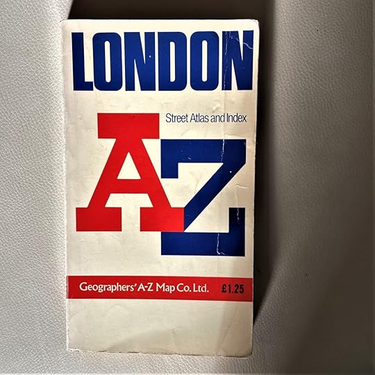

The guide pairs well with an undated, yellowed and dog-eared London A-Z Street Guide I picked up somewhere. London is crammed with tiny streets and a magnifying glass would be helpful when putting the pages to use. I know I’ve never used it to tour, but it is great for following stories set in London even though 221B Baker Street isn’t a real address. (The Holmes Museum is in the same block however.) But who doesn’t want to walk on Green Dragon or Honeypot Lanes or perhaps Prioress Street?
If nothing else, the two books are great for reading period British mysteries, my favorite.
My favorite of the non-Italian guides is a 1912 Baedeker’s Palestine and Syria with Routes through Mesopotamia and Babylonia and the Island of Cyprus. It’s a Fifth Edition so not monetarily valuable. The flyleaf says it was owned by D. P. Wetherald, who was in Cairo on March 7, 1914, only a few short months before Europe and the Middle East were convulsed by World War I. It wasn’t long before Lawrence of Arabia dashed around (think Peter O’Toole and Omar Sharif) doing in the Ottomans, and a few years before Gertrude Bell and Winston Churchill redrew the map of the Middle East, setting off unrest and war that has never really ended. I originally thought that someone inscribing their name in a book with only initials would be male. So maybe Wetherald was a British secret agent fomenting unrest for Great Britain to gain the upper hand for the empire?


The red-bound book is crammed with pages of advice like how to contract with a dragoman (tour manager): “breakfast shall be served at … and shall consist of …” He must provide ladies saddles if applicable, dining tents, pay the locals, and always be courteous and obliging, etc. There are charts for comparing the myriad different currencies including gold napoleons, mejidis, piastres and beshliks, and useful expressions in Arabic such as how to find a toilet. There is a whole chapter on “Intercourse with Orientals” including avoiding familiarity and how time means nothing. Rather different to today’s guides.
My traveler penciled in dates for some of the stops. The first one is The Church of the Holy Sepulcher in Jerusalem on March 11. My assumption about the traveler changed to doubt when I found the remains of tiny wildflowers pressed into the pages for Acre, famous for its Crusader castle, and on the page describing the Cedars of Lebanon which the traveler visited in early April along with the ruins of Baalbek sometime after a stay in Damascus Syria. Both these sites are marked with the blue and red silk ribbons that came with the book.


Whoever Wetherald was, he or she was likely religious as on the last page there are some notes: “The Talisman; Song of the Syrian Guest; The Koran Christ – Osborn; D Murray– Holy Land & Egypt; Bless Him.” The Talisman is a story by Sir Walter Scott published in 1825 and set at the time of the Crusades; The Song of Our Syrian Guest was published in 1904 on a Christian theme.
I can imagine Mr. or Miss Wetherald and companions, tired from traveling by carriage and likely the famous Hejaz railway, enjoying a picnic arranged by the dragoman with thick coffee or weak tea (cucumber sandwiches?) as they reclined on a rug overlooking a grove of olive trees and evocative ruins unaware of the coming storm that would engulf much of the world. Their tour is good fodder for a novel for sure, but should it be a romance or a thriller?
All photos copyright Judith Works
December 15, 2022
BUCHART GARDENS – A feast for the eyes
One goal of the trip to Victoria was to revisit nearby Buchart Gardens, 55 acres of glorious shrubs, trees and flowers developed in 1904 on grounds of an old limestone quarry. It had been years since we’d enjoyed the gardens. As beautiful as ever, they must be one of the premier gardens in the world no matter the season. Happily for us, fellow garden lovers were few and tour buses not in evidence this post-Labor Day time when the gardens are beginning to be readied for fall. Leaves were turning but summer flowers still abounded especially in the enormous and glorious hanging baskets.
So many flowers!!

Paths lead walkers around and down to the Sunken Garden and through several types of garden design: A rose garden where the roses still bloomed in October, Japanese, Renaissance Italian, and Mediterranean.

The gardens host sculptures and fountains.

The snail was particularly captivating but Ross Fountain that sprayed water 70 feet into the soft autumn air was mesmerizing with its continual dance of water droplets.

If I had to choose any garden design it would be that of the Japanese esthetic. There is something about the way the designer weaves rock, sand, water, moss, lanterns, bridges along pathways, and green plantings in a contemplative whole that conveys a sense of peace and of things beyond daily mundane existence. A garden such as this always gives solace to my soul.

We entered through the red torii gate and began our quiet stroll around and over streams and ponds pausing every few steps to admire the artistry and infinite care that goes into such a garden.


The sun was well over the meridian, and it was time for late lunch at their café before returning to Victoria to plan for more sightseeing. Isn’t planning a big part of the travel experience? It is for us.

Copyright Judith Works
November 4, 2022
Victoria – waterborne city of flowers
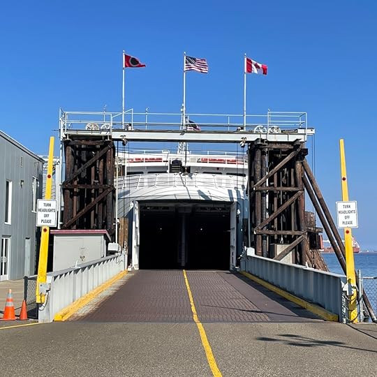
Covid was waning and the U.S. – Canadian border was finally open again. The weather was good and the Black Ball Ferry Line from Port Angeles to Victoria was finally back in operation. So, we decided to head out for a change of scene to refresh our thoughts after the seemingly endless months of contagion concern.
I like some really old-fashioned expressions such as “sea-girt” a term that perfectly describes the city of Victoria, British Columbia perched on the rocky shores of the southern tip of Vancouver Island reached by sea or air. The area, known as “Canada’s Hawaii” (which says something about the Canadian climate), is a Pacific Northwest temperate climate zone on the Straits of Juan de Fuca where the waters of the Pacific Ocean sweep in to form the Salish Sea to the south in the US, and the Inside Passage north to Alaska, both waterways dotted with a spray of islands.
For Canada, it’s an old city. Founded in 1843 as a Hudson Bay trading post, it’s now a low-key city full of parks and Victorian and Edwardian-style buildings mingled with modern buildings housing high-tech companies. As capital of British Columbia, the city hosts politicians to fill the beautiful Parliament Buildings, which date to 1893, and students from the university. But the city makes much of its living from tourists who fill the hotels lining the streets along the water. Besides the ferries bringing them and us to docks on the Inner Harbor, there is also a cruise terminal on the Strait where thousands on shore excursions enjoy the city for a day as part of their itinerary as they sail to or from Alaska in the summer. At least one of the regularly visiting ships is two stories taller than the tallest building in town.
Given the number of tourists, Victoria occasionally suffers from Ye Olde England kitsch with an abundance of offers for high tea, British memorabilia, and horse-drawn tally-ho wagons.

As an antidote, indigenous local tribes who were pushed out by incoming mostly British settlers, have regained a presence near the Parliament grounds to host a traditional longhouse and totem poles carved by these coast Salish peoples. The poles, so emblematic of coastal Pacific Northwest from Alaska to northern Washington State, are carved from Western Red Cedar. The brightly-colored intertwined animals and people, mythical and real, are of spiritual reverence or tell stories of family and clan. The longhouse with its sea-monster design sits in the midst of the poles. As we contemplated the artistry, we could hear drumming and see rising smoke attesting to native culture keeping traditions alive.

The Royal British Columbia Museum has a treasure trove of Native American art and culture spanning thousands of years. The artifacts are a testimony to the culture’s endurance against long odds. Formerly dismissed as unimportant or not art, their highly stylized carvings, silver jewelry, bentwood boxes, prints, and weaving are now in major museums and art galleries worldwide.
Beyond its history, Victoria is a city for walking and biking along the trails lining the harbor and the ocean. And it’s a city where gardening appears to be an obsession with even sub-tropical plants flourishing in the summer.
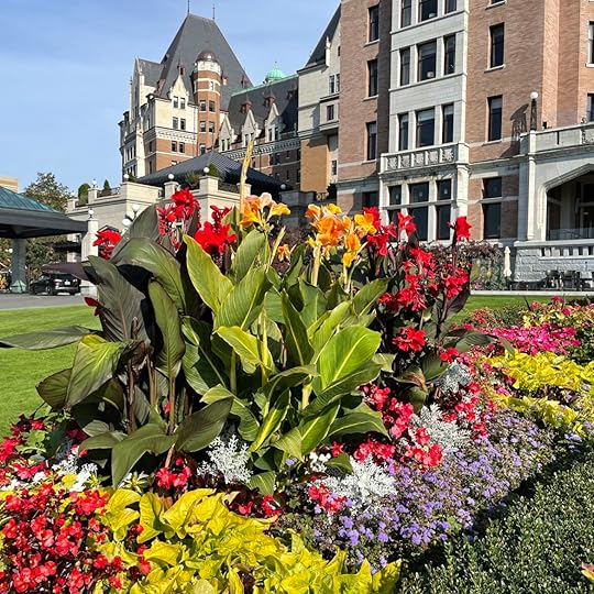
We started our flower tour by enjoying the display at the historic Empress Hotel, built in 1908, before walking around the lovely Inner Harbor where hanging baskets of flowers grace the path.

Seaplanes were landing and taking off, tugs guided barges under a couple of bridges toward the commercial end of the waters.

Adding to the scene, the Port Angeles ferry arrived with another load of passengers and their cars, and the Victoria Clipper boarded for the afternoon return trip to Seattle.
The 1924 Ferry Building that formerly hosted earlier passenger ship incarnations had a photo mural from the 1940s with the famous art-Deco style Kalakala ferry docked alongside two of the regular ferries that plied the waters. Sadly, that other-worldly 1930s craft was broken up for scrap several years ago. I’m one of many who thought it should have been preserved.

Footsore, we boarded one of the many tiny water taxis that dot the water for a tour. They are so cute I kept taking photos as they glided over the placid waters.

Later, we sat outside for dinner at the Ferry Building (seafood of course) and waited for darkness to bring on the light show where the Parliament building is outlined in white lights, a plaza with all the heraldic emblems of Canada’s provinces and a fountain glowed red. The lights from moored boats and seaplanes shimmered in the water, and the bascule bridge leading to the upper harbor, lit in purple and white, raised and lowered to accommodate water traffic.
A pleasant way to spend an evening planning our next days’ tours.
July 23, 2022
ARIZONA – Excursion to Tumacacori and Tubac

What is it about ruins that many, including me, find so compelling? The melancholy half-fallen buildings make me try to visualize the labors of those who built them. What were their lives like and why were the buildings abandoned? What does a tiny graveyard say about the injury and disease that must have wracked the local people? My attempts to imagine what their lives were really like is doomed to failure because of the passage of time and mostly unbridgeable cultural differences. But the artifacts they left give hints that pull me in.
Such is the case with the mission at Tumacacori, now cared for by the National Park Service. The inhabitants of this area were and still are O’odhham, farmers who grew corn, beans, and squash on land irrigated by what is now called the Santa Cruz river. The mission was founded in 1751 as part of a string of “civilizing” settlements in the southwest of what is now Arizona and northwest Mexico and abandoned 1848 after repeated Apache raids.

The last time I visited was a cloudy day several years ago and works to restore the site seemed to be minimal at best. Depressing. This time, the sun lit the old buildings. The church dome was freshly whitewashed, in brilliant contrast to the blue sky.
The interior of the never-completed church was lit by the desert light.


The storehouse was restored as was a round mortuary chapel next to a tiny graveyard. What happened to all the others who must have died, I wondered.


After contemplating the small museum showing mission life, my friend and I took a pre-lunch walk through the newly planted orchard to the Santa Clara River. It sparkled in the sunlight and bright red cardinals flitted from branch to branch. No wonder ancient peoples settled here.

Tubac, a few miles north is a tiny town devoted to tourism in the form of shopping and eating. It was time for lunch at the famous Elvira’s restaurant before succumbing to the delights of browsing the shops My friend had a Chile Relleno and I had a salad to ensure room for dessert. If you’re into all things shiny, this is the place for you because the restaurant and home décor store pay homage to everything bright and glittery.


More typical brightly-colored wares, ceramic and painted metal, are displayed in other shops. No doubt suitable for the desert environment but I couldn’t image them in the cloudy Pacific Northwest.


I couldn’t resist a photo of what might be called industrial art on the way to a store devoted to all things cooks might need or be tempted to try. I passed on the instant pasta, a sacrilege for one who’d lived in Italy.


On our shopping walk we passed typical and beautiful ristas – braided bunches of dried chile peppers for Southwest cooking.

On the way back to home base in Green Valley, we took in one more bit of local architecture (a steak restaurant of course) before sipping gin and tonics on the patio to watch the setting sun flood the desert with golden light.

All photos copyright Judith Works
May 15, 2022
Bisbee – From Mining to Tourism
“Rumors are they’ve found a big vein of gold.” We were huddled under blankets on a freezing morning when Dorothy, our golf-cart driver and guide set the brake at the top of a hill to respond to my question about the fate of long-abandoned mines near the town.

We, and two friends were on an early-morning tour of Bisbee, a town in southeastern Arizona with houses clinging to steep barren hills above the commercial area down in a gulch watered by a clear stream. Formerly filled with miners and chancers, the town is now home to artists and old hotels and B&Bs that play on its history.

That history is mining. The town was founded in 1880 to support the Copper Queen Mine and in 1917, a gigantic open pit mining operation to meet copper demand from World War I. The pit, called Lavender after a former executive, is an astounding site – 300 acres wide and 900 feet deep. The surrounding area is a maze of hills erected from the tons of waste from the mines. Mining ceased in 1975 after producing 8 billion pounds of copper, 100 million ounces of silver and 2.5 million ounces of gold.

All was not well between owners and workers and in 1917 one of the most infamous events in the battle between labor and management in the United States occurred. Miners attempted to organize to secure better working conditions and pay supported by the famed (infamous to some) IWW international union often called The Wobblies. The owner of the mine at the time, the Phelps Dodge corporation, used private police and deputized sheriffs to kidnap nearly 1200 men.


They were marched a couple of miles to a baseball stadium before herding them into cattle cars where they were transported without food and water to be dumped in the New Mexico desert sixteen hours later. The Governor of New Mexico called in the Army to move them to a town twenty miles away to get shelter. No one was ever successfully prosecuted, and the Supreme Court ruled the Constitution didn’t prohibit abductions even crossing state lines! (Wikipedia has an interesting history of this event under the title “Bisbee Deportations”).
According to Guide Dorothy, the descendants of these miners are still embittered. I would be too.
Our golf cart continued trundling up and down the steep hills to look at the small homes perched precariously one above the other, a brightly trimmed Methodist church still in use. It wasn’t hard to picture what went on in the gulch below on payday.


Some of the newer homes featured street-side art work. One especially creative idea was to inset rainbows of colored glass on a retaining wall. The morning sun lit up the rainbow of colors. Another home had angels protecting the entrance.


The tour concluded with a view of the 1940-era Art Deco style Cochise County office fronted by an oversize statue of Copper Man (unfortunately sharing the space with a telephone pole).

It was nearing lunch time. We drove to a little cluster of buildings called Lowell outside the main town. While we waited for a table at the Bisbee Breakfast Club, we contented ourselves looking around the one-street “commercial district” which was a model of time-travel back to the Nineteen Forties and Fifties. One shop had that vibrating belt women used to take fat off unwanted places along with a barbell and an uncomfortable-looking rowing machine.

The Huevos Rancheros at the café were delicious but I kept looking out to window to see if any flying saucers were approaching!


All photos copyright by Judith Works except the historic photos of the deportation which are public domain.
March 28, 2022
Arizona Borderlands

Wanting a taste of the Old West, we headed for the Slaughter Ranch and its restored 1880’s home in the far southeast corner of Cochise County on the Mexican border. The ranch is named for the “legendary” Texas John Slaughter, a lawman with a violent name who kept the peace in the old-fashioned way with pistols and rifles. I’d never heard of him, but it turned out he was a famous character with quite a history: Confederate War veteran, long-horn cattle driver on the famous Chisholm Trail, and then owner of the enormous cattle ranch in the then Arizona Territory.
In 1886, five years after the storied gunfight at the OK Corral in Tombstone, he was elected sheriff of Cochise County. He was an Indian fighter and brought various desperadoes and cattle thieves to justice all the while playing poker and running his ranch. Obviously, times were different then.
Of course, he has his own Wikipedia page, and his exploits warranted a 1958 Disney series as well as a book series, the jacket blurb on one calling him “the toughest lawman west of the Rio Grande.”
The drive to and from the dusty border town of Douglas was 18 miles of rough dirt road bordered by the famous or infamous depending on your view of the matter: The Wall. Mile after mile of posts snaking over barren ridges and washes and across flats in a dark line.

Two lonely purple port-a-potties rested on a trailer on a wide-spot in the road. Border Patrol pickups hauling horse trailers, and vans passed by leaving us in the dust. Our driver said he wouldn’t stop for anyone on the road, and if threatened he’d use his Lugar! I don’t know what he was expecting but the next thing I knew a guy in a pickup stopped in front of us. We drew up beside him. I sunk down in my seat. He rolled his window down to ask if this was the way to the ranch and said he was a distant relative from Texas. No Wild West shootout after all. The last we saw of him was at the ranch gate looking at the large sign that said NO DOGS ALLOWED while his dog sniffed around the cattle guard.

The ranch house and outbuildings were not lavish in any way but furnished in the style of the era and location with the laundry and cookhouse in separate buildings.


The main house with its parlor and furnished bedrooms lacked indoor plumbing and one look at the coffin-like bathtub made me shiver at the thought of a winter bath.


The last room on the tour, obviously furnished as part of the house’s designation as one of the National Register of Historic Homes, was filled with newspaper and magazine articles, movie posters, and other publicity about the good sheriff.


Among the posters I spotted a recruiting bill from Pancho Villa encouraging gringos to join his ragtag band to fight in the 1913-14 Mexican Revolution for gold and glory. Both hero and criminal he is most famous in the U.S. for raiding a small border town, Columbus, New Mexico, killing some 18 people in an effort to get military supplies. This resulted in the US unsuccessfully pursuing him into Mexico for several years.

Borderlands are often in dispute and this area is no different from many others. But the days of bow-tied sheriffs holding cigars and rifles seem far away from today’s deadly terrors.
All photos copyright Judith Works
February 10, 2022
WUPATKI NATIONAL MONUMENT
Explorers of the West in the 19th Century like John Wesley Powell marveled at the scattered ruins of pueblos and strange volcanic landscape that makes up the area called Wupatki one of the many National Monuments in Central Arizona. So did we.

The scenic road from Sedona led us north winding around hairpin turns through Oak Creek Canyon and up over the Mongollan Rim at 8000 ft altitude. The road widened as we continued through wildflower-carpeted Ponderosa Pine woodlands to Flagstaff. Along the way there were stands where Native American silver jewelry was displayed for sale.

It was tempting to turn either directly east to Winona and Gallup or west to Barstow and San Bernadino as the lyrics of Nat King Kole’s wonderful song about Route 66 – which bisects Flagstaff – advises. But it was a day to get our kicks further north at Wupatki in the southwestern corner of the Colorado Plateau inhabited by much earlier travelers who followed a different open road. It is an area of high desert, a scrub and grassland where lava flows and the black cinder cone of Sunset Crater dominate the southern half of the natural scene and the remnants of ancient pueblos of the Wupatki complex dot the northern section of the landscape.

We turned off Highway 89, the road to the Grand Canyon and Lake Powell, to visit the pueblos – small ruins of several hamlets on the way to the Visitor Center and the Wupatki Pueblo, the biggest and best preserved in the Monument. Of the three National Monuments we visited on this trip it was by far the most spectacular and with its combination of red sandstone, black basalt and pale limestone slabs that make up the buildings, stark ruins against the deep blue sky.


The buildings of the main pueblo with about 100 rooms, some several stories high, were entered by ladder from a hole in the roof. They have been vacant for some 700 years but for the 400 years preceding, a society apparently composed of unrelated groups managed to develop a rich culture despite the challenging environment.

I pictured the round community center, filled with traders bringing their seashells, turquoise, copper bells, scarlet macaws, and over 125 kinds of pottery to trade for woven painted cloth.
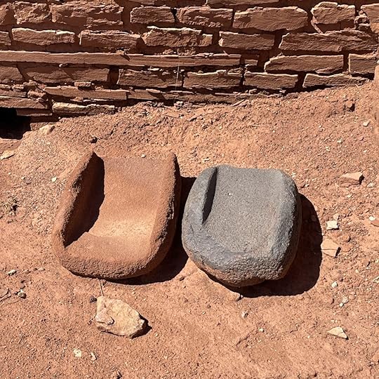
And then, like the other sites we visited, the people moved on. Two stone metates rested on the ground – left behind in the migration to other sites where perhaps the living was easier for two women who’d knelt to grind the corn from the nearby small garden plots.
Now, besides a few tourists and a couple of National Park Service staff, the only evidence of life I saw was this fat lizard shading himself from the heat of the day.

All photos copyright Judith Works
January 11, 2022
ARIZONA – Montezuma’s Castle and Well
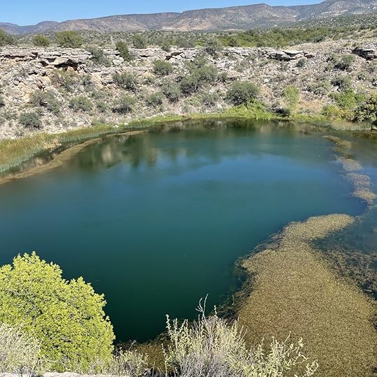
The second historic site near Sedona, Montezuma Castle National Monument has more to capture the eye and thoughts of the past than the meager remains of Tuzigoot. Early Spanish explorers thought the “castle” was built by the Aztecs. An offshoot of the monuments is called Montezuma’s Well, a watering source used by the local people for irrigation. Both parts are misnamed as the Aztecs lived thousands of miles south and the castle is a cliff house and there is no well.

We began at the “well,” a limestone sinkhole fed by continuously flowing springs under the desert scrublands. After climbing up to the rim in 95-degree heat, I stood by a wind and heat-blasted twisted juniper to look at an algae and reed-fringed round pond. It looked viscous in the boiling heat, definitely not a swimming hole with the water containing high amounts of carbon dioxide and arsenic. No fish but five unique species survive including leeches that don’t suck blood but eat tiny crustacean. Even so, their presence is a compelling reason to keep one’s toes away in case the leeches are looking for a dietary supplement.

I was much too hot to descend 112 steps down to the water (and back up) anyway, but I could see cliff dwellings built by the Sinauga people tucked away under the limestone rim. It must have been cozy in the blazing heat of summer. Interestingly, the name Sinauga means without water, attesting to their culture that survived with a bare minimum.

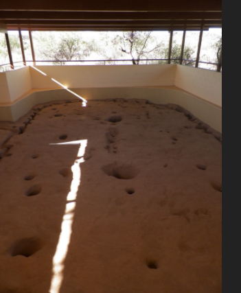
Nearby are the remains of a pit house where the earlier Hohokam peoples lived. It dates to about 1050 AD. We looked down to see the remaining oval floor with holes where two timbers held up a roof made of smaller timbers and reed thatch. The thought of living underground like this is unimaginable to me: Claustrophobic with its eternal darkness. I don’t know how they survived but they did for many generations until like at other sites, they moved on.
More relatable is the “Castle,” a cliff house tucked into an overhang, practically a four-star location in comparison to the pit house. The site isn’t extensive like Mesa Verde in New Mexico but still gives a glimpse into the building skills of these industrious peoples. The dwelling appears to be high over the floor of the valley although in reality it is “only” 100 feet. Still, climbing a ladder, surely not OSHA approved, up and down for farming and hunting must have taken a terrible toll. Like at Tuzigoot, windows were not a priority. Perhaps their building skills were insufficient or perhaps it was for protection. Whatever the reason, I imagined the women inside hoping for a sunny day to cast a few beams of light into the home or storeroom.

By 1425 the dwellings were empty but descendants like the Hopi, Zuni and Yavapai still return to honor the site. The Western Apache as well revere this landscape. Where did these people come from? New theories add that they may have come by sea as well as the land bridge from Asia during the Ice Age. And the timelines are repeatedly pushed back from 13,000 years ago to perhaps 30,000 with every new relic discovered.

The hot breeze rustled the dried grasses and the leaves of the cottonwood and sycamore trees while I tried to picture these peoples climbing on unsteady ladders into their nearly windowless storage rooms and homes and wondered if we are headed for the same fate: to disappear only to have future generations gawk in wonder at the ruins we may leave and wonder where we went.
All photos copyright Judith Works except that of the Pit House floor from the National Park Service.
For more photos of the National Monument see Photos & Multimedia – Montezuma Castle National Monument (U.S. National Park Service) (nps.gov)