
Jeffrey E.F. Friedl's Blog, page 27
July 11, 2015
Riding Kyoto’s “Heart Loop” With Friends
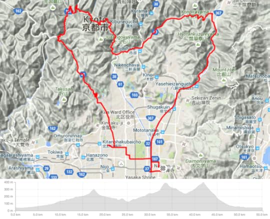
Kyoto's “Heart Loop” Cycling Route
From my house it's 55km with 800m of vertical climb (34mi / 2,600')
Yesterday I finally did the “Heart Loop” route that seems to be a local
favorite. It goes over three not-very-big passes, which in the
counter-clockwise order that I did it yesterday are Ebumi (江文峠),
Mochikoshi (持越峠), and Kyomi (京見峠). Total elevation gain is only 800m
(2,600'), so it's not very challenging unless you choose to make it so by
really pushing.
昨日、やっと「ハートルップ」と言うサイクリングコースをやってみました。
名前の意味は「♡形の一周」です。距離は55キロ、獲得高度は800メートルです。
Panasonic LX100 at an effective 35mm — 1/320 sec, f/5.6, ISO 200 —
map & image data — nearby photos
Foggy Gathering
この間雨中のサイクリングをしましたのでカメラのレンズは曇ってた。掃除のを忘れた!
My previous few rides have been in the rain, and so my camera lens got a
layer of something on it that I neglected to clean off, and so the photos
are all hazy and indistinct. 
The lens aside, it was a nice ride with nice folks: Manseki (Japan), Ross (Canada), Michael (USA), and meeting for the first time, Iago (Spain).
We met near Sanjo Starbucks as usual, and got moving at 7:42am.
Panasonic LX100 at an effective 24mm — 1/640 sec, f/5.6, ISO 200 —
map & image data — nearby photos
Duckies in a Row
7:50am - taken while cycling at 42 kph (26 mph)
Panasonic LX100 at an effective 29mm — 1/640 sec, f/5, ISO 200 —
map & image data — nearby photos
Iago
this guy is really fast
( but I hope his lack of a helmet never comes back to bite him )
7:56am - taken while cycling at 28 kph (17 mph)
Panasonic LX100 at an effective 29mm — 1/1600 sec, f/5, ISO 200 —
map & image data — nearby photos
Ross
with his trademarked passive expression
7:56am - taken while cycling at 19 kph (12 mph)
Panasonic LX100 at an effective 29mm — 1/800 sec, f/5, ISO 200 —
map & image data — nearby photos
Stoplight Group Selfie
Panasonic LX100 at an effective 44mm — 1/250 sec, f/5, ISO 200 —
map & image data — nearby photos
Michael
His excellent posture makes his arms look extra long
8:18am - taken while cycling at 27 kph (17 mph)
Panasonic LX100 at an effective 25mm — 1/640 sec, f/5, ISO 200 —
map & image data — nearby photos
Brake-Adjust Break
Panasonic LX100 at an effective 24mm — 1/400 sec, f/5, ISO 200 —
map & image data — nearby photos
Selfish Jerk
我儘な危ない運転
8:54am - taken while cycling at 47 kph (29 mph)
I snapped the photo above to record the license plate of the car in case trouble arose from his dangerous driving. Our speed was limited by the mini pickup truck in front of us, so we had no trouble keeping pace with traffic
and were not slowing him down in the least, but I sensed that he took it as an affront that bicycles were in front
of him, so he tailgated for a long while before just deciding to push forward despite there being nowhere to go. He endangered all of us for precisely zero gain.
Half a minute later, he turned toward the city and we turned onto a small road farther into the mountains as we started
up the left-side “lobe” of the heart.
This part of the course leads 6.8km (4.2mi) to the start of the next
climb. The route is mostly rising, but overall there's only 190m (620') of
elevation gain, so it's not challenging if you don't push. Ross and Iago
were idly chatting as they lazily road together most of the way, but their
“lazily” pretty much perfectly matched my “pushing fairly hard”, so they
were in sight most of the time.
Panasonic LX100 at an effective 62mm — 1/160 sec, f/5.6, ISO 200 —
map & image data — nearby photos
Posing
9:12am - taken while cycling at 21 kph (13 mph)
When I took these photos of Iago acting silly for the camera, it was on
a fairly steep uphill section, but he just kept pumping away.
Panasonic LX100 at an effective 75mm — 1/250 sec, f/5.6, ISO 200 —
map & image data — nearby photos
'cause I didn't have the camera ready the first time
The next climb, to Mochikoshi Pass, is a bit intense. It's just 1.05km (0.65mi) long,
but it rises 108m (354'), making for an average slope of 10.3%. I'd descended it before, but this
was my first time to climb it.
It took me 6:27. Iago
took only 4:54. Ross has done it faster, but took his sweet time today with
a relaxing 5:18. Michael and Manseki apparently chatted the whole time, so
took it much easier.
Panasonic LX100 at an effective 75mm — 1/125 sec, f/3.5, ISO 200 —
map & image data — nearby photos
Cresting the Pass
持越峠
in a photo-recreation moments after the actual event
I'm still trying to get used to the Panasonic LX100 that I bought for cycling. The lag between pressing the shutter button and the photo actually being taken bites me sometimes. I think that has something to do with
why the photo above is not panned well (I think I stopped panning once I thought the picture was taken). I was going for
something like this.
I did better a few moments later when Iago was playing around...
Panasonic LX100 at an effective 46mm — 1/125 sec, f/4, ISO 200 —
map & image data — nearby photos
Silly
On the way back we crested Kyomi Pass from the north. I was happy to make a PR (personal record),
besting the PR I'd set last Wednesday, shaving 11 seconds off to 12:18.
Panasonic LX100 at an effective 24mm — 1/125 sec, f/2.2, ISO 200 —
map & image data — nearby photos
Pitstop at NORU
for coffee or, er, etc
Panasonic LX100 at an effective 37mm — 1/50 sec, f/2.4, ISO 1600 —
map & image data — nearby photos
Admiring the Fine Bouquet
as Ross and Josh test grinds on the new espresso machine
( they were really testing grinds, but this photo is totally staged )
The route home brought me across the bottom of the Kyoto Imperial Palace Park, and I was booking it with
an average speed of 40kph (25mph). It turns out that this puts me as the
sixth faster person to register this segment with Strava. I've held the sixth-place ranking on a segment before, but this is the first time
it's been for a segment with more than six registered riders. In this case I'm sixth out of “1,390 attempts by 265 people”.
I think I've got it in me to shave a few more seconds off. We'll see.
All in all it was a very nice little ride. I got to meet Iago, and of course I always enjoy riding with good folks like Ross, Manseki, and Michael. I was back home by noon to get started on work for the day.


July 6, 2015
Bicycle Ride Around Japanâs Largest Lake, Part 2
Panasonic LX100 at an effective 24mm — 1/800 sec, f/5.6, ISO 200 —
map & image data — nearby photos
Choppy Day on Northern Lake Biwa
11:38 AM (+6h 11m) - 105 km (65.5 miles)
taken while cycling at 28 kph (17 mph)
ä¸ã¶æåã®çµç¶æ¹ä¸å¨ã®ç©èªãç¶ãã¾ãã第ä¸å¹ã¯ãã¡ãã
I'm finally getting around to continue the story from
“Bicycle Ride Around Japanâs Largest Lake, Part 1”,
a 230km (143 mile) ride I did with a few friends a month ago. I've done a bunch of long
rides since (115km, 143km, 147km,
145km, 50km, and 140km), but this remains my longest ride so far.
Here I'll repeat the map that leads the first post:
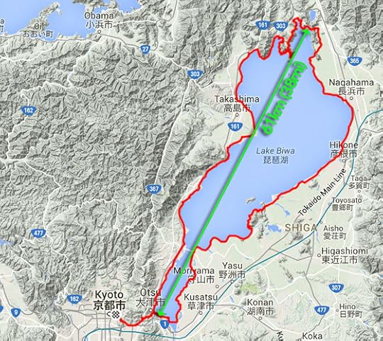
230km (143 miles) by bicycle
In the upper-rightish is the city of Nagahama, and that's about where
the first post ended, so that's where this one picks up. We're moving
around the lake in a counter-clockwise direction,
so we're still not half way.
For a while north of Nagahama there's no road along the shore, so we have to head inland a bit...
Panasonic LX100 at an effective 25mm — 1/1000 sec, f/5.6, ISO 200 —
map & image data — nearby photos
Amber Waves of Grain
11:44 AM (+6h 17m) - 107 km (66.6 miles)
taken while cycling at 21 kph (13 mph)
Panasonic LX100 at an effective 52mm — 1/1000 sec, f/5.6, ISO 200 —
map & image data — nearby photos
11:44 AM (+6h 17m) - 107 km (66.7 miles)
taken while cycling at 20 kph (13 mph)
Panasonic LX100 at an effective 24mm — 1/1600 sec, f/5.6, ISO 200 —
map & image data — nearby photos
11:44 AM (+6h 18m) - 107 km (66.7 miles)
taken while cycling at 20 kph (12 mph)
Panasonic LX100 at an effective 24mm — 1/800 sec, f/5.6, ISO 200 —
map & image data — nearby photos
Stardestroyer
11:48 AM (+6h 21m) - 109 km (67.6 miles)
taken while cycling at 22 kph (14 mph)
There wasn't much traffic this far north in the boonies, but at one
point a huge crane slowly passed us, making me feel like Princess Leia
consular vessel being slowly overtaken and consumed by Darth Vader's
Imperial Stardestroyer.
At about our half-way point, the main road goes through a long modern tunnel under some mountains. We'd rather go over the mountains, so we got onto the old original road and climbed the 50 vertical meters to
an old tunnel...
Panasonic LX100 at an effective 24mm — 1/60 sec, f/9, ISO 1000 —
map & image data — nearby photos
12:03 PM (+6h 36m) - 113 km (70.5 miles)
The name, written above the entrance (backwards) is ã賤ã¶å¶½é§éã,
using the old word (suido) that's since been replaced by the
Japanification of the English word “tunnel”. According to a plaque just
inside the entrance, it took a bit more than a year of digging to break through
the 1,260 shaku of length (382m / 418yd), and another two and a half years
to actually finish the tunnel in 1927 at a cost of 279,642 yen. I
don't know what the exchange rate was 88 years ago, but today that's about
$2,250.
Panasonic LX100 at an effective 30mm — 1/20 sec, f/13, ISO 1600 —
map & image data — nearby photos
Inside the tunnel it was pitch black except for a splash of light in the
center. Even in the day where you can easily see both openings, I wouldn't
want to do it without a light, for fear of monsters and creepy things. Ugh.
But a slow shutter can see in the dark, so after I got home I got to actually see what the inside
of the tunnel looked like:
Panasonic LX100 at an effective 24mm — 1/8 sec, f/1.7, ISO 1600 —
map & image data — nearby photos
Better Off Not Knowing
12:07 PM (+6h 40m) - 114 km (70.6 miles)
taken while cycling at 11 kph (7 mph)
Through to the other side, we were treated to a nice view of the lake....
Panasonic LX100 at an effective 24mm — 1/1250 sec, f/3.5, ISO 200 —
map & image data — nearby photos
60m Above Lake Biwa
12:09 PM (+6h 43m) - 114 km (70.8 miles)
This is pretty much at the exact spot where the green arrow in the map above touches at the top.
Panasonic LX100 at an effective 65mm — 1/200 sec, f/7.1, ISO 200 —
map & image data — nearby photos
Heading Back Down
12:16 PM (+6h 49m) - 115 km (71.1 miles)
The most direct path around the lake cuts off a peninsula of mountains that pierces the lake at its top,
but of course we wanted to hug the lake as much as possible, and climb the mountains as much as possible...
Panasonic LX100 at an effective 24mm — 1/400 sec, f/5.6, ISO 200 —
map & image data — nearby photos
Heading Into the Mountains
12:40 PM (+7h 14m) - 120 km (74.4 miles)
taken while cycling at 19 kph (12 mph)
Half an hour of hard climbing later...
Panasonic LX100 at an effective 28mm — 1/250 sec, f/10, ISO 200 —
map & image data — nearby photos
View Of Lake Biwa
from 280m above the surface
1:13 PM (+7h 46m) - 126 km (78.0 miles)
Panasonic LX100 at an effective 54mm — 1/100 sec, f/10, ISO 640 —
map & image data — nearby photos
Well-Earned Rest
1:15 PM (+7h 48m) - 126 km (78.0 miles)
Panasonic LX100 at an effective 50mm — 1/160 sec, f/6.3, ISO 200 —
map & image data — nearby photos
Another Pause Lower Down
240m above
1:36 PM (+8h 9m) - 130 km (80.6 miles)
Panasonic LX100 at an effective 32mm — 1/250 sec, f/6.3, ISO 200 —
map & image data — nearby photos
Plummeting Down
1:43 PM (+8h 17m) - 131 km (81.4 miles)
I went ahead and tried to set up for a panning “action” shot of Gorm
flying by, hoping I'd get everything blurry except him....
Panasonic LX100 at an effective 24mm — 1/60 sec, f/6.3, ISO 500 —
map & image data — nearby photos
1:47 PM (+8h 21m) - 134 km (83.0 miles)
He's sort of blurry too, but I'll claim partial success.
Once we alighted from the mountain, we had a pretty simple/flat 60-or-so
kilometers (~40mi) shot down along the shore to complete our loop.
Panasonic LX100 at an effective 35mm — 1/160 sec, f/6.3, ISO 200 —
map & image data — nearby photos
Annoying Japanese Habit
2:32 PM (+9h 6m) - 147 km (91.4 miles)
taken while cycling at 25 kph (15 mph)
Japanese people seem to love to smolder plant clippings, spreading smoke
everywhere. One farmer deciding to get rid of some cuttings can ruin a
whole town's futons and other fabrics hug out to dry. It boggles my mind,
but people just seem to think it's natural.
Two hours after descending the mountain, we catch our first sight of the
gate for the Shirohige Shrine, which we'd visited from the other (closer to
Kyoto) direction a month prior on my first ride that exceeded 100km. That
was the subject of “Pleasant 105km Bike Ride
Takashimaâs Shirohige Shrine”...
Panasonic LX100 at an effective 24mm — 1/400 sec, f/5.6, ISO 200 —
map & image data — nearby photos
First Sight of the Shrine Gate
(I think ... it'd be pretty tiny in this photo)
3:51 PM (+10h 24m) - 170 km (105.6 miles)
taken while cycling at 15 kph (9 mph)
20 minutes and 8km later, we're much closer...
Panasonic LX100 at an effective 25mm — 1/320 sec, f/6.3, ISO 200 —
map & image data — nearby photos
4:12 PM (+10h 45m) - 178 km (110.8 miles)
taken while cycling at 26 kph (16 mph)
Panasonic LX100 at an effective 28mm — 1/1000 sec, f/3.5, ISO 200 —
map & image data — nearby photos
Arrival
4:15 PM (+10h 48m) - 179 km (111.1 miles)
Shirahige Shrine (ç½é¬ç¥ç¤¾)
This was the first thing around the whole lake that was familiar, and at
least to me signaled the end of the challenge. Now we just had to get
home, but that was still a few hours off.
Panasonic LX100 at an effective 29mm — 1/125 sec, f/5.6, ISO 200 —
map & image data — nearby photos
Labor-Intensive Farming
5:11 PM (+11h 44m) - 198 km (123.0 miles)
taken while cycling at 29 kph (18 mph)
Finally at 6:00 in the evening we overlapped our morning path, completing our trip around the lake.
Panasonic LX100 at an effective 24mm — 1/1000 sec, f/2.2, ISO 200 —
map & image data — nearby photos
Objective Achieved
6:00 PM (+12h 33m) - 216 km (134.0 miles)
This was taken near the site of this photo from the
morning, almost 12 hours earlier.
Panasonic LX100 at an effective 24mm — 1/800 sec, f/2.2, ISO 200 —
map & image data — nearby photos
Now that we had completed the loop, we had to pop back over to Kyoto,
which first involved a 105m climb over a small mountain...
Panasonic LX100 at an effective 75mm — 1/125 sec, f/2.8, ISO 500 —
map & image data — nearby photos
Cresting the Pass
6:35 PM (+13h 9m) - 219 km (135.8 miles)
I'm happy with the amount of blur I get in the wheels and spokes at this shutter speed.
Kumiko was happy because she could do the hill (and indeed the entire
day) in her clip-in shoes. It gave her a lot of confidence with them.
Gorm was happy because he got to have a nice rest while waiting for us; he flew up that mountain.
Part of the descent down the other side is really steep, but the effect
is enhanced by being right next to a highway....
Panasonic LX100 at an effective 75mm — 1/160 sec, f/2.8, ISO 200 —
map & image data — nearby photos
Landing Approach
6:37 PM (+13h 10m) - 219 km (136.2 miles)
taken while cycling at 20 kph (12 mph)
After that, just before arriving home, there was one final 50m hill. The other side of the hill was the first
little climb of the day, and I was happy to find out when looking at the data later that I made a personal-best fast time on
both the climb leaving Kyoto that morning,
and the climb returning home that evening.
Both little climbs were ones that I had given my all on before, so it was all the more gratifying to make PRs on them
as bookmarks to my longest ride (in time and distance).
I returned home after almost 14 hours on the bike, and felt great. I guess distance doesn't tire me out, just vertical
climb, and this one had only about 1,500m (4,800 ft). The rides I've done since are shorter, but usually have
much more mountain climbing.
Bicycle Ride Around Japan’s Largest Lake, Part 2
Panasonic LX100 at an effective 24mm — 1/800 sec, f/5.6, ISO 200 —
map & image data — nearby photos
Choppy Day on Northern Lake Biwa
11:38 AM (+6h 11m) - 105 km (65.5 miles)
taken while cycling at 28 kph (17 mph)
一ヶ月前の琵琶湖一周の物語を続きます。第一幕はこちら。
I'm finally getting around to continue the story from
“Bicycle Ride Around Japan’s Largest Lake, Part 1”,
a 230km (143 mile) ride I did with a few friends a month ago. I've done a bunch of long
rides since (115km, 143km, 147km,
145km, 50km, and 140km), but this remains my longest ride so far.
Here I'll repeat the map that leads the first post:
230km (143 miles) by bicycle
In the upper-rightish is the city of Nagahama, and that's about where
the first post ended, so that's where this one picks up. We're moving
around the lake in a counter-clockwise direction,
so we're still not half way.
For a while north of Nagahama there's no road along the shore, so we have to head inland a bit...
Panasonic LX100 at an effective 25mm — 1/1000 sec, f/5.6, ISO 200 —
map & image data — nearby photos
Amber Waves of Grain
11:44 AM (+6h 17m) - 107 km (66.6 miles)
taken while cycling at 21 kph (13 mph)
Panasonic LX100 at an effective 52mm — 1/1000 sec, f/5.6, ISO 200 —
map & image data — nearby photos
11:44 AM (+6h 17m) - 107 km (66.7 miles)
taken while cycling at 20 kph (13 mph)
Panasonic LX100 at an effective 24mm — 1/1600 sec, f/5.6, ISO 200 —
map & image data — nearby photos
11:44 AM (+6h 18m) - 107 km (66.7 miles)
taken while cycling at 20 kph (12 mph)
Panasonic LX100 at an effective 24mm — 1/800 sec, f/5.6, ISO 200 —
map & image data — nearby photos
Stardestroyer
11:48 AM (+6h 21m) - 109 km (67.6 miles)
taken while cycling at 22 kph (14 mph)
There wasn't much traffic this far north in the boonies, but at one
point a huge crane slowly passed us, making me feel like Princess Leia
consular vessel being slowly overtaken and consumed by Darth Vader's
Imperial Stardestroyer.
At about our half-way point, the main road goes through a long modern tunnel under some mountains. We'd rather go over the mountains, so we got onto the old original road and climbed the 50 vertical meters to
an old tunnel...
Panasonic LX100 at an effective 24mm — 1/60 sec, f/9, ISO 1000 —
map & image data — nearby photos
12:03 PM (+6h 36m) - 113 km (70.5 miles)
The name, written above the entrance (backwards) is 「賤ヶ嶽隧道」,
using the old word (suido) that's since been replaced by the
Japanification of the English word “tunnel”. According to a plaque just
inside the entrance, it took a bit more than a year of digging to break through
the 1,260 shaku of length (382m / 418yd), and another two and a half years
to actually finish the tunnel in 1927 at a cost of 279,642 yen. I
don't know what the exchange rate was 88 years ago, but today that's about
$2,250.
Panasonic LX100 at an effective 30mm — 1/20 sec, f/13, ISO 1600 —
map & image data — nearby photos
Inside the tunnel it was pitch black except for a splash of light in the
center. Even in the day where you can easily see both openings, I wouldn't
want to do it without a light, for fear of monsters and creepy things. Ugh.
But a slow shutter can see in the dark, so after I got home I got to actually see what the inside
of the tunnel looked like:
Panasonic LX100 at an effective 24mm — 1/8 sec, f/1.7, ISO 1600 —
map & image data — nearby photos
Better Off Not Knowing
12:07 PM (+6h 40m) - 114 km (70.6 miles)
taken while cycling at 11 kph (7 mph)
Through to the other side, we were treated to a nice view of the lake....
Panasonic LX100 at an effective 24mm — 1/1250 sec, f/3.5, ISO 200 —
map & image data — nearby photos
60m Above Lake Biwa
12:09 PM (+6h 43m) - 114 km (70.8 miles)
This is pretty much at the exact spot where the green arrow in the map above touches at the top.
Panasonic LX100 at an effective 65mm — 1/200 sec, f/7.1, ISO 200 —
map & image data — nearby photos
Heading Back Down
12:16 PM (+6h 49m) - 115 km (71.1 miles)
The most direct path around the lake cuts off a peninsula of mountains that pierces the lake at its top,
but of course we wanted to hug the lake as much as possible, and climb the mountains as much as possible...
Panasonic LX100 at an effective 24mm — 1/400 sec, f/5.6, ISO 200 —
map & image data — nearby photos
Heading Into the Mountains
12:40 PM (+7h 14m) - 120 km (74.4 miles)
taken while cycling at 19 kph (12 mph)
Half an hour of hard climbing later...
Panasonic LX100 at an effective 28mm — 1/250 sec, f/10, ISO 200 —
map & image data — nearby photos
View Of Lake Biwa
from 280m above the surface
1:13 PM (+7h 46m) - 126 km (78.0 miles)
Panasonic LX100 at an effective 54mm — 1/100 sec, f/10, ISO 640 —
map & image data — nearby photos
Well-Earned Rest
1:15 PM (+7h 48m) - 126 km (78.0 miles)
Panasonic LX100 at an effective 50mm — 1/160 sec, f/6.3, ISO 200 —
map & image data — nearby photos
Another Pause Lower Down
240m above
1:36 PM (+8h 9m) - 130 km (80.6 miles)
Panasonic LX100 at an effective 32mm — 1/250 sec, f/6.3, ISO 200 —
map & image data — nearby photos
Plummeting Down
1:43 PM (+8h 17m) - 131 km (81.4 miles)
I went ahead and tried to set up for a panning “action” shot of Gorm
flying by, hoping I'd get everything blurry except him....
Panasonic LX100 at an effective 24mm — 1/60 sec, f/6.3, ISO 500 —
map & image data — nearby photos
1:47 PM (+8h 21m) - 134 km (83.0 miles)
He's sort of blurry too, but I'll claim partial success.
Once we alighted from the mountain, we had a pretty simple/flat 60-or-so
kilometers (~40mi) shot down along the shore to complete our loop.
Panasonic LX100 at an effective 35mm — 1/160 sec, f/6.3, ISO 200 —
map & image data — nearby photos
Annoying Japanese Habit
2:32 PM (+9h 6m) - 147 km (91.4 miles)
taken while cycling at 25 kph (15 mph)
Japanese people seem to love to smolder plant clippings, spreading smoke
everywhere. One farmer deciding to get rid of some cuttings can ruin a
whole town's futons and other fabrics hug out to dry. It boggles my mind,
but people just seem to think it's natural.
Two hours after descending the mountain, we catch our first sight of the
gate for the Shirohige Shrine, which we'd visited from the other (closer to
Kyoto) direction a month prior on my first ride that exceeded 100km. That
was the subject of “Pleasant 105km Bike Ride
Takashima’s Shirohige Shrine”...
Panasonic LX100 at an effective 24mm — 1/400 sec, f/5.6, ISO 200 —
map & image data — nearby photos
First Sight of the Shrine Gate
(I think ... it'd be pretty tiny in this photo)
3:51 PM (+10h 24m) - 170 km (105.6 miles)
taken while cycling at 15 kph (9 mph)
20 minutes and 8km later, we're much closer...
Panasonic LX100 at an effective 25mm — 1/320 sec, f/6.3, ISO 200 —
map & image data — nearby photos
4:12 PM (+10h 45m) - 178 km (110.8 miles)
taken while cycling at 26 kph (16 mph)
Panasonic LX100 at an effective 28mm — 1/1000 sec, f/3.5, ISO 200 —
map & image data — nearby photos
Arrival
4:15 PM (+10h 48m) - 179 km (111.1 miles)
Shirahige Shrine (白鬚神社)
This was the first thing around the whole lake that was familiar, and at
least to me signaled the end of the challenge. Now we just had to get
home, but that was still a few hours off.
Panasonic LX100 at an effective 29mm — 1/125 sec, f/5.6, ISO 200 —
map & image data — nearby photos
Labor-Intensive Farming
5:11 PM (+11h 44m) - 198 km (123.0 miles)
taken while cycling at 29 kph (18 mph)
Finally at 6:00 in the evening we overlapped our morning path, completing our trip around the lake.
Panasonic LX100 at an effective 24mm — 1/1000 sec, f/2.2, ISO 200 —
map & image data — nearby photos
Objective Achieved
6:00 PM (+12h 33m) - 216 km (134.0 miles)
This was taken near the site of this photo from the
morning, almost 12 hours earlier.
Panasonic LX100 at an effective 24mm — 1/800 sec, f/2.2, ISO 200 —
map & image data — nearby photos
Now that we had completed the loop, we had to pop back over to Kyoto,
which first involved a 105m climb over a small mountain...
Panasonic LX100 at an effective 75mm — 1/125 sec, f/2.8, ISO 500 —
map & image data — nearby photos
Cresting the Pass
6:35 PM (+13h 9m) - 219 km (135.8 miles)
I'm happy with the amount of blur I get in the wheels and spokes at this shutter speed.
Kumiko was happy because she could do the hill (and indeed the entire
day) in her clip-in shoes. It gave her a lot of confidence with them.
Gorm was happy because he got to have a nice rest while waiting for us; he flew up that mountain.
Part of the descent down the other side is really steep, but the effect
is enhanced by being right next to a highway....
Panasonic LX100 at an effective 75mm — 1/160 sec, f/2.8, ISO 200 —
map & image data — nearby photos
Landing Approach
6:37 PM (+13h 10m) - 219 km (136.2 miles)
taken while cycling at 20 kph (12 mph)
After that, just before arriving home, there was one final 50m hill. The other side of the hill was the first
little climb of the day, and I was happy to find out when looking at the data later that I made a personal-best fast time on
both the climb leaving Kyoto that morning,
and the climb returning home that evening.
Both little climbs were ones that I had given my all on before, so it was all the more gratifying to make PRs on them
as bookmarks to my longest ride (in time and distance).
I returned home after almost 14 hours on the bike, and felt great. I guess distance doesn't tire me out, just vertical
climb, and this one had only about 1,500m (4,800 ft). The rides I've done since are shorter, but usually have
much more mountain climbing.
July 3, 2015
That Kyoto Temple With the Many Whimsical Statues
Nikon D4 + Voigtländer 125mm f/2.5 — 1/320 sec, f/2.5, ISO 5600 —
map & image data — nearby photos
Things are Looking Up
at the Otagi Nenbutsuji Temple (愛宕念仏寺), Kyoto Japan
Nikon D700 + Voigtländer 125mm f/2.5 — 1/640 sec, f/2.5, ISO 900 —
map & image data — nearby photos
though this guy
Seems Grumpy
Vertical Desktop-Background Versions
1050×1680 · 1200×1920 · 1600×2560
After so many cycling-related posts lately, it's time I get back to my basics with some pretty photos.
最近僕のブログはサイクリング関係ばかりみたいので、やっぱりたまに美しい京都の写真にも戻らなければいけない。
I've been meaning to write about the Otagi Nenbutsuji Temple (愛宕念仏寺)
temple for years, and indeed all the photos on this post are from 2012
(from visits to the temple in April and December of that year). A few of
the photos appeared a year ago in “A Few Desktop Backgrounds
from the Delightfully Whimsical Otaginenbutsuji Temple”, and one
appears as the subject of my Photo-Development
Challenge #2.
Nikon D700 + Voigtländer 125mm f/2.5 — 1/1250 sec, f/2.5, ISO 2500 —
map & image data — nearby photos
Entrance Path
Vertical Desktop-Background Versions
1050×1680 · 1200×1920 · 1600×2560
It's at the far north end of the Arashiyama area that is already filled with more temples and shrines than someone could
see in a week, and it's sort of a hidden treasure, so it's not particularly crowded. Tourists who walk what they think is the
full length of Arashiyama probably stop here because it simply looks
like there's nothing beyond. But only a short distance farther is an amazing place.
The temple is most noted for its 1,200 often-whimsical statues carved from stone.
Sometimes they're scattered about haphazardly like those on Easter Island...
Nikon D700 + Nikkor 85mm f/1.4 — 1/640 sec, f/1.4, ISO 900 —
map & image data — nearby photos
Desktop-Background Versions
1280×800 · 1680×1050 · 1920×1200 · 2560×1600 · 2880×1800
Sometimes they're packed in tightly like sardines in a can...
Nikon D700 + Nikkor 85mm f/1.4 — 1/640 sec, f/2.8, ISO 900 —
map & image data — nearby photos
Each has its individual charm (and I believe each was carved by a
different person), so there are always more fun things to notice each time
you visit, or even each time you look at their photos. I just noticed that
the subject of the aforementioned photo
challenge can be found in the shot above.
Nikon D700 + Nikkor 85mm f/1.4 — 1/640 sec, f/1.4, ISO 400 —
map & image data — nearby photos
Bighead and Little Bob
( I just made up those names )
Nikon D700 + Nikkor 85mm f/1.4 — 1/640 sec, f/1.4, ISO 500 —
map & image data — nearby photos
Phyllis Diller and J. Wellington Wimpy?
Nikon D700 + Nikkor 85mm f/1.4 — 1/640 sec, f/1.4, ISO 1000 —
map & image data — nearby photos
Paul Barr
Nikon D700 + Nikkor 85mm f/1.4 — 1/640 sec, f/1.4, ISO 720 —
map & image data — nearby photos
Walkman
the statues date from 1980s ~ 1990s
Nikon D4 + Voigtländer 125mm f/2.5 — 1/320 sec, f/2.5, ISO 5600 —
map & image data — nearby photos
Walkman Again
this time in December
Nikon D4 + Voigtländer 125mm f/2.5 — 1/320 sec, f/2.5, ISO 4000 —
map & image data — nearby photos
Damien Douxchamps
The visit in December 2012 with Damien was at the end of a photographically-productive day
that yielded a lovely rainbow,
some stunning fall colors,
autumn views of the Jojuji Temple,
and assorted other beauty.
Nikon D700 + Nikkor 85mm f/1.4 — 1/640 sec, f/4, ISO 5000 —
map & image data — nearby photos
So Much Detail
and if you've read my blog for long, you know I like taking photos of other photographers taking photos
Desktop-Background Versions
1280×800 · 1680×1050 · 1920×1200 · 2560×1600 · 2880×1800
Nikon D700 + Nikkor 85mm f/1.4 — 1/640 sec, f/1.4, ISO 320 —
map & image data — nearby photos
Nikon D700 + Nikkor 85mm f/1.4 — 1/640 sec, f/1.4, ISO 500 —
map & image data — nearby photos
Nikon D700 + Nikkor 85mm f/1.4 — 1/640 sec, f/1.4, ISO 250 —
map & image data — nearby photos
Nikon D4 + Nikkor 50mm f/1.4 — 1/160 sec, f/1.4, ISO 320 —
map & image data — nearby photos
Vertical Desktop-Background Versions
1050×1680 · 1200×1920 · 1600×2560
Nikon D4 + Voigtländer 125mm f/2.5 — 1/320 sec, f/2.5, ISO 5000 —
map & image data — nearby photos
The Office
( USA version)
Nikon D700 + Voigtländer 125mm f/2.5 — 1/640 sec, f/2.5, ISO 720 —
map & image data — nearby photos
At the top of the entrance path are three bells that have the most lovely sound...
Nikon D4 + Nikkor 50mm f/1.4 — 1/320 sec, f/2, ISO 1400 —
map & image data — nearby photos
Nikon D700 + Nikkor 85mm f/1.4 — 1/640 sec, f/1.4, ISO 1000 —
map & image data — nearby photos
You can ring them freely. The deep, rich sound is sublime.
Nikon D700 + Nikkor 85mm f/1.4 — 1/640 sec, f/1.4, ISO 2000 —
map & image data — nearby photos
Nikon D700 + Voigtländer 125mm f/2.5 — 1/640 sec, f/2.5, ISO 2500 —
map & image data — nearby photos
Freshman
Nikon D700 + Voigtländer 125mm f/2.5 — 1/640 sec, f/2.5, ISO 280 —
map & image data — nearby photos
Bright
Nikon D4 + Nikkor 50mm f/1.4 — 1/320 sec, f/5.6, ISO 7200 —
map & image data — nearby photos
Nikon D4 + Nikkor 50mm f/1.4 — 1/160 sec, f/5.6, ISO 4500 —
map & image data — nearby photos
Nikon D700 + Voigtländer 125mm f/2.5 — 1/640 sec, f/2.5, ISO 4000 —
map & image data — nearby photos
Nikon D700 + Nikkor 85mm f/1.4 — 1/640 sec, f/1.4, ISO 500 —
map & image data — nearby photos
Vertical Desktop-Background Versions
1050×1680 · 1200×1920 · 1600×2560
Nikon D700 + Nikkor 85mm f/1.4 — 1/640 sec, f/2.8, ISO 2200 —
map & image data — nearby photos
Bet You Don't See It
Vertical Desktop-Background Versions
1050×1680 · 1200×1920 · 1600×2560
Nikon D700 + Voigtländer 125mm f/2.5 — 1/640 sec, f/2.5, ISO 1000 —
map & image data — nearby photos
Nikon D700 + Voigtländer 125mm f/2.5 — 1/640 sec, f/2.5, ISO 3600 —
map & image data — nearby photos
Nikon D4 + Voigtländer 125mm f/2.5 — 1/320 sec, f/2.5, ISO 1600 —
map & image data — nearby photos
Nikon D4 + Voigtländer 125mm f/2.5 — 1/320 sec, f/2.5, ISO 6400 —
map & image data — nearby photos
Cold and Wet
that December day was
Nikon D4 + Voigtländer 125mm f/2.5 — 1/320 sec, f/2.5, ISO 2200 —
map & image data — nearby photos
Nikon D4 + Nikkor 50mm f/1.4 — 1/160 sec, f/1.4, ISO 160 —
map & image data — nearby photos
The End
There's so much more there... most of the statues didn't appear here at all. Perhaps I'll have to return again...
June 29, 2015
Many Lessons Learned on Yesterday’s Group Ride
Panasonic LX100 at an effective 24mm — 1/125 sec, f/1.8, ISO 200 —
map & image data — nearby photos
Large Group Ride
pausing after the first steep climb
in the mountains above the Arashiyama area of Kyoto, Japan
I went on a bicycle ride yesterday that involved 13 people, the largest
group I'd been on to date. It was fun, but I also learned some important
lessons.
Panasonic LX100 at an effective 37mm — 1/160 sec, f/2.4, ISO 200 —
map & image data — nearby photos
Gathering
Sanjo-Street Bridge over the Kamo River (三条大橋)
Panasonic LX100 at an effective 37mm — 1/160 sec, f/2.4, ISO 200 —
map & image data — nearby photos
It was quite the international gathering, with folks from
Australia,
Canada,
England,
Finland,
Japan,
Norway,
Philippines,
and
The States.
The first lesson I learned was to pay attention to what weather forecast
I looked at. Yesterday in Kyoto city proper the actual weather (spritzy
rain in the morning; otherwise sunny all day) sort of matched the forecast
(10% chance of rain all day), but our ride into the mountains was in the
mountains, and it rained almost the entire time.
Panasonic LX100 at an effective 24mm — 1/1000 sec, f/1.7, ISO 200 —
map & image data — nearby photos
Heading Out
lead by Nigel and Andy
6:20 AM (+4 min) - 1.2 km (0.8 miles)
Panasonic LX100 at an effective 72mm — 1/200 sec, f/2.8, ISO 200 —
map & image data — nearby photos
Waiting at a Traffic Light
like good cyclists do
Panasonic LX100 at an effective 72mm — 1/500 sec, f/2.8, ISO 1250 —
map & image data — nearby photos
Scenic Route
6:27 AM (+11 min) - 3.4 km (2.1 miles)
Panasonic LX100 at an effective 75mm — 1/125 sec, f/4.5, ISO 200 —
map & image data — nearby photos
Not-so-Scenic Route
6:31 AM (+15 min) - 4.7 km (2.9 miles)
Panasonic LX100 at an effective 24mm — 1/125 sec, f/5.6, ISO 200 —
map & image data — nearby photos
Nigel Randell
6:45 AM (+29 min) - 10 km (6.2 miles)
taken while cycling at 36 kph (22 mph)
Nigel does an amazing
amount of cycling, including commute-to-work rides exceeding 100km.
So far this year, including during the winter,
he's averaged 1500km (890 miles) per month.
Panasonic LX100 at an effective 24mm — 1/125 sec, f/5.6, ISO 200 —
map & image data — nearby photos
Leading the Parade
6:45 AM (+29 min) - 10 km (6.3 miles)
Panasonic LX100 at an effective 75mm — 1/125 sec, f/5.6, ISO 200 —
map & image data — nearby photos
Minor Slope
6:46 AM (+30 min) - 10 km (6.3 miles)
taken while cycling at 19 kph (12 mph)
The pair in orange are father/son, with the boy being in sixth grade. He had not the slightest problem keeping with the group. They joined us only
for the beginning, and split off before the steep climbs, but I suspect
both could have handled it easily.
Panasonic LX100 at an effective 70mm — 1/125 sec, f/4, ISO 200 —
map & image data — nearby photos
Arashiyama
6:54 AM (+37 min) - 13 km (8.2 miles)
I always like riding through this part of northern Arashiyama. Here
we're going by the Hokyo-in Temple (宝筐院), which is just stunning in autumn.
We soon dove into the forest-covered mountains, and a light spritzy/misty rain started that didn't let up.
After the first short (but intense) climb, we took the group photo that leads this post.
Being both wet and steep, we took the descents quite slowly...
Panasonic LX100 at an effective 47mm — 1/100 sec, f/3.5, ISO 200 —
map & image data — nearby photos
Careful Descent
7:09 AM (+53 min) - 16 km (9.9 miles)
Panasonic LX100 at an effective 24mm — 1/125 sec, f/4, ISO 200 —
map & image data — nearby photos
Social Pause
7:41 AM (+1h 24m) - 22 km (13.6 miles)
There's a tiny village halfway up the first major climb, and normally
one would not stop here, but with a large group of varying abilities, it's
nice to stop from time to time to keep people more or less together.
The fastest folks arrived at the top long before me and the other
slowpokes, and went partially down the other side and returned back up to
the pass not long after I arrived...
Panasonic LX100 at an effective 70mm — 1/125 sec, f/2.8, ISO 1000 —
map & image data — nearby photos
Heading Home
8:07 AM (+1h 50m) - 26 km (16.0 miles)
With various family obligations, they returned home the way we came, while the rest of us continued away from the city.
Panasonic LX100 at an effective 24mm — 1/125 sec, f/5.6, ISO 200 —
map & image data — nearby photos
Picturesque Stop
“京都市有形文化財河原家住宅”
Kyoto City Tangible Cultural Asset “Kawara Family Home”
8:24 AM (+2h 8m) - 29 km (17.8 miles)
Panasonic LX100 at an effective 30mm — 1/125 sec, f/2.2, ISO 250 —
map & image data — nearby photos
Random Jovialty
8:40 AM (+2h 24m) - 33 km (20.7 miles)
Panasonic LX100 at an effective 75mm — 1/125 sec, f/2.8, ISO 2000 —
map & image data — nearby photos
Lovely Descent
8:41 AM (+2h 25m) - 34 km (21.0 miles)
This descent, like the rest of the planned route, follows the same path
that Gorm and I did two
weeks ago. Like last time, I couldn't get good shots down this
super-nice descent. The rain didn't help.
The rain also didn't help one rider, Dario, who for unknown reasons lost
control on a slow straightaway and met the ground.
Panasonic LX100 at an effective 24mm — 1/125 sec, f/1.7, ISO 1250 —
map & image data — nearby photos
Fixing a Boo-Boo
8:43 AM (+2h 26m) - 34 km (21.1 miles)
I was really impressed with how Antti (from Finland)
took control of the situation, tending to the road rash in a no-nonsense
way, then tending to the bicycle (making sure it was safe to ride), all the
while tending to everyone's emotions. He brought calm and direction where
it was needed.
Many good lessons here for everyone.
We didn't have much in the way of first-aid supplies with us
(which is to say we had nothing; I had a few Band-Aids, but they were of no use here),
so Antti made do with what we had. My little towel became a protective wrap.
Panasonic LX100 at an effective 24mm — 1/60 sec, f/1.7, ISO 400 —
map & image data — nearby photos
Putting a Happy Face on It
when pride is certainly wounded
Dario was certainly in discomfort for a while, but a day later
he's already saying he's ready to ride again with us soon.
Back to yesterday, in going over the bicycle to make sure it was safe to
ride, Antti adjusted a few bolts with a small multi-tool thing he had. I
don't think anyone else had anything like that, and this was another lesson
for me. Mechanical issues can pop up any time, so I should have some basic
tools with me. If I was going to spend the weight to have some tools, I wanted to get something that would actually be useful, so I ordered this Crank Brothers
tool. It's a little heavy and has mixed reviews, so here's keeping my
fingers crossed.
We continued as a group until we got to a turnoff that lead back to
Kyoto. I had intended to return at this point anyway, since I had family
things to do myself. Four of us headed back via a small mountain road.
Then I got my first flat as a cyclist.
Panasonic LX100 at an effective 24mm — 1/160 sec, f/2, ISO 200 —
map & image data — nearby photos
Sad Tire
9:29 AM (+3h 13m) - 45 km (27.8 miles)
The others were in a rush just to get home in the cold rain, and there was nothing they
could do while I changed the flat, so I told them to continue on.
I'd never changed a flat, nor even seen it done except in a couple of
YouTube videos that I watched some months ago. But it turned out to be
straightforward to change the tube, and aside from the most dirty I think
my hands have ever gotten, there were no problems.
Panasonic LX100 at an effective 24mm — 1/320 sec, f/2.2, ISO 200 —
map & image data — nearby photos
Change in Progress
9:40 AM (+3h 24m) - 45 km (27.8 miles)
Panasonic LX100 at an effective 43mm — 1/160 sec, f/2.5, ISO 200 —
map & image data — nearby photos
Looks Like a Half-Eaten Carcass
The new tube was in and filled, and I was about ready to put the wheel
back onto the bike when I had the bright idea to actually check the tread
to see whether I could find what caused the flat. If there was a nail or
something in there, it'd just pop the new tube right away.
I wasn't quite prepared for what I found:
Panasonic LX100 at an effective 28mm — 1/1000 sec, f/2.1, ISO 200 —
map & image data — nearby photos
Ridiculously Bad Shape
This is not a tire that's just gone bad... this tire has apparently been
beyond bad for a long time. This wear extends around much of one half of
the tire, and it's unfathomable how neither I nor the mechanics who have
worked on my bike over the last months have not noticed it. This is worse
than first noticing you're pregnant because the baby just fell out.
I knew immediately that I was in trouble, because with a huge hole worn
through the tire, there was nothing to protect the tube. I actually got a
few very-careful kilometers on it, enough to get to a convenience store and
wash my hands, but it soon was flat again.
I was 50km (30 miles) from home, in the middle of nowhere, with a bike I couldn't ride.
Thankfully, my father-in-law could come and pick me up. I pushed the
bike to a michi
no eki (道の駅) that was conveniently close and waited.
Panasonic LX100 at an effective 43mm — 1/160 sec, f/7.1, ISO 200 —
map & image data — nearby photos
Dad Saves the Day
11:50 AM
June 26, 2015
Cycling Along the River from Kyoto To Osaka Castle
Panasonic LX100 at an effective 24mm — 1/125 sec, f/5.6, ISO 200 —
map & image data — nearby photos
Typical Preflight Camaraderie
7:21 AM
across from Sanjo Starbucks, Kyoto Japan (京都市の三条大橋)
今回のサイクリングは京都→大阪→妙見山(豊能郡)→京都でした。この記事は大阪城までの分を含めている。
For our Wednesday ride this week, the plan was to cycle down to Osaka
and see the city a bit, then slog up through the
dense suburbia to the mountains, then up and over them back to Kyoto.
This post is about 49-km (31-mile) ride from Kyoto to Osaka, primarily
on bike paths along the rivers that cut through the concrete jungle filling
the flatlands between mountains (the concrete jungle seen in this long
shot of the Osaka skyline from Kyoto).
Panasonic LX100 at an effective 46mm — 1/160 sec, f/5.6, ISO 200 —
map & image data — nearby photos
Heading Down to the Kamo River
7:38 AM (+9 min) - 2.8 km (1.8 miles)
taken while cycling at 14 kph (9 mph)
This time I've based the time (“+9
min” above) and distance (“2.8 km” above) under
each photo on the start of the group ride, rather than (as in previous
cycling posts) from when I left my house.
Within Kyoto City proper, the “path” along the river is really a bunch
of path segments haphazardly connected by trips across bridges, around
people's homes, and sometimes on the street. The track of the ride at
Strava can show you the way if you'd like to make the trip yourself
sometime. In our case, we were led by veteran rider Manseki Kanemitsu (who appeared on my blog
yesterday in a shot from this outing).
Panasonic LX100 at an effective 24mm — 1/400 sec, f/5.6, ISO 200 —
map & image data — nearby photos
Down Close to the River
7:48 AM (+18 min) - 6.5 km (4.0 miles)
taken while cycling at 24 kph (15 mph)
Panasonic LX100 at an effective 54mm — 1/320 sec, f/5.6, ISO 200 —
map & image data — nearby photos
Above the River
7:53 AM (+24 min) - 9.1 km (5.7 miles)
taken while cycling at 29 kph (18 mph)
Panasonic LX100 at an effective 75mm — 1/200 sec, f/5.6, ISO 200 —
map & image data — nearby photos
“All the Happiness”
on a well-used path away from traffic
7:54 AM (+25 min) - 9.7 km (6.0 miles)
taken while cycling at 29 kph (18 mph)
Panasonic LX100 at an effective 41mm — 1/800 sec, f/3.5, ISO 200 —
map & image data — nearby photos
Excellent View of Utility Cables
very typical Japan
7:58 AM (+29 min) - 11 km (7.1 miles)
taken while cycling at 32 kph (20 mph)
Panasonic LX100 at an effective 52mm — 1/800 sec, f/3.5, ISO 200 —
map & image data — nearby photos
Small-Plot Farming
individuals making use of the fertile flood plain between the path and the river
7:58 AM (+29 min) - 12 km (7.2 miles)
taken while cycling at 33 kph (21 mph)
Panasonic LX100 at an effective 24mm — 1/800 sec, f/3.5, ISO 200 —
map & image data — nearby photos
Temporary Detour
8:01 AM (+32 min) - 13 km (8.1 miles)
taken while cycling at 26 kph (16 mph)
Panasonic LX100 at an effective 24mm — 1/500 sec, f/5.6, ISO 200 —
map & image data — nearby photos
Rush-Hour Traffic
one of these gentleman is on this ride
8:02 AM (+33 min) - 14 km (8.5 miles)
taken while cycling at 34 kph (21 mph)
Panasonic LX100 at an effective 62mm — 1/500 sec, f/3.5, ISO 200 —
map & image data — nearby photos
Dipping Under Traffic
8:02 AM (+33 min) - 14 km (8.6 miles)
taken while cycling at 26 kph (16 mph)
Panasonic LX100 at an effective 24mm — 1/250 sec, f/5.6, ISO 200 —
map & image data — nearby photos
Racing Form
Michael Edwards overtakes me at a brisk clip
8:07 AM (+38 min) - 16 km (10.1 miles)
taken while cycling at 34 kph (21 mph)
Panasonic LX100 at an effective 24mm — 1/500 sec, f/3.5, ISO 200 —
map & image data — nearby photos
Sidestepping Over Merging Rivers
8:08 AM (+39 min) - 17 km (10.4 miles)
taken while cycling at 19 kph (12 mph)
Here we cross from riding along the Kamo River, over both the Uji River and the Kitsu River, just above the point
they all merge to become the mighty Yodo River. Even though it had been eight years since I'd been there, I recognized it right away as the location of
“Cherry Blossoms
in the Middle of Three Rivers”, about the mile-long island where these rivers come together, completely covered by cherry trees.
I'd definitely like to come back here next spring.
Once we get alongside the Yodo River, the path opens up to a wide, pristinely-smooth blacktop.
Panasonic LX100 at an effective 24mm — 1/500 sec, f/5.6, ISO 200 —
map & image data — nearby photos
Pristine Wide Smooth Path
( the line of darker trees across the background are all cherry )
ここからしばらくめちゃ良いな川治パース
8:10 AM (+41 min) - 18 km (10.9 miles)
taken while cycling at 10 kph (6 mph)
Panasonic LX100 at an effective 24mm — 1/320 sec, f/5.6, ISO 200 —
map & image data — nearby photos
Gorm Attack!
(“Attack” is a cycle-racing term for an aggressive move to distance yourself from followers)
8:11 AM (+42 min) - 18 km (11.1 miles)
taken while cycling at 34 kph (21 mph)
I've still got to get the hang of my new camera for
cycling. For the kind of side-shot above, I wanted a slow enough
shutter to blur the background and the wheels, but I didn't do it nearly
enough.
I would have liked to experiment more, but there's only so much Jeffrey I can subject these guys to.
So speaking of subjecting them to me, with the path so wonderfully wide, I thought a lined-up-abreast shot might be nice, so I had them line
up...
Panasonic LX100 at an effective 24mm — 1/500 sec, f/3.5, ISO 200 —
map & image data — nearby photos
Three Musketeers
8:13 AM (+44 min) - 19 km (12.0 miles)
taken while cycling at 30 kph (19 mph)
... then I asked them to pretend to attack, but they all
instinctively put on the afterburners and even though I tried to accelerate
with them, they left me in the dust. A mere eight seconds after the shot
above, they were red-shifting away from me...
Panasonic LX100 at an effective 24mm — 1/500 sec, f/3.5, ISO 200 —
map & image data — nearby photos
8 Seconds Later
8:14 AM (+44 min) - 19 km (12.0 miles)
taken while cycling at 35 kph (22 mph)
Panasonic LX100 at an effective 24mm — 1/500 sec, f/3.5, ISO 200 —
map & image data — nearby photos
8:18 AM (+48 min) - 21 km (13.3 miles)
taken while cycling at 36 kph (22 mph)
Panasonic LX100 at an effective 24mm — 1/500 sec, f/3.5, ISO 200 —
map & image data — nearby photos
Stupid Most-Hated Gates
この馬鹿なバイク止めはめちゃ邪魔。別な方法もうないの?
8:21 AM (+52 min) - 23 km (14.3 miles)
The name in Japanese of these moronic gates is バイク止め
(“anti-motorcycle gate”), but in practice they are “anti-ankle,
anti-derailleur, anti-progress” gates. There are about a dozen of them on
the route we took.
Above, Michael is passing through incorrectly. Manseki had shown Gorm and me a month earlier, so Gorm knew
the correct (though visually-comical) way...
Panasonic LX100 at an effective 24mm — 1/500 sec, f/3.5, ISO 200 —
map & image data — nearby photos
Proper Technique
正しい通り方
Panasonic LX100 at an effective 30mm — 1/500 sec, f/3.5, ISO 400 —
map & image data — nearby photos
High-Speed Chat
with the wide, smooth path and lack of traffic, we had ample opportunity to chat
8:25 AM (+56 min) - 25 km (15.7 miles)
taken while cycling at 33 kph (20 mph)
Panasonic LX100 at an effective 40mm — 1/1000 sec, f/3.5, ISO 200 —
map & image data — nearby photos
8:33 AM (+1h 4m) - 29 km (18.0 miles)
taken while cycling at 25 kph (16 mph)
Panasonic LX100 at an effective 28mm — 1/1000 sec, f/3.5, ISO 200 —
map & image data — nearby photos
Manseki Attack!
金光万石さんのアタックの真似
8:38 AM (+1h 9m) - 32 km (19.7 miles)
taken while cycling at 34 kph (21 mph)
Manseki used to be a professional athlete (skiing), so he's used to putting on
his “game face” for the camera.
Unlike yesterday's
“Manseki Attack!” photo that resulted from a
camera mistake on my part, this one was exposed properly, but I like yesterday's result so sort of went in the same
direction for this one.
I wanted to do similar treatments for Michael and Gorm, but I didn't
have an appropriate base photo to start with.
Panasonic LX100 at an effective 75mm — 1/800 sec, f/5.6, ISO 200 —
map & image data — nearby photos
Stuck in Traffic
渋滞
8:42 AM (+1h 12m) - 33 km (20.6 miles)
taken while cycling at 28 kph (17 mph)
Panasonic LX100 at an effective 50mm — 1/1250 sec, f/5.6, ISO 200 —
map & image data — nearby photos
First View of Downtown Osaka
if you zoom way up you can barely make out the hazy outline of some skyscrapers
大阪市内はちらっと見る
8:47 AM (+1h 18m) - 36 km (22.2 miles)
taken while cycling at 23 kph (14 mph)
DMC-SZ9 at an effective 26mm — 1/1000 sec, f/3.1, ISO 100 —
map & image data — nearby photos
Balancing
僕、時速28キロで動いてるけれども、動いてないみたい
8:53 AM (+1h 23m) - 38 km (23.8 miles)
photo by Manseki Kanemitsu, while cycling at 28 kph (17 mph)
This shot by Manseki illustrates why I need to pay attention to the
shutter speed... at 1/1,000th of a second, the lack
of blur in the wheels makes it look like I'm standing still. I'm not that well balanced.
Panasonic LX100 at an effective 24mm — 1/2000 sec, f/5.6, ISO 200 —
map & image data — nearby photos
Gone Fishing
9:01 AM (+1h 32m) - 43 km (26.5 miles)
taken while cycling at 32 kph (20 mph)
Panasonic LX100 at an effective 75mm — 1/500 sec, f/3.5, ISO 200 —
map & image data — nearby photos
First Good View of Osaka
やっと大阪市内ははっきり見えます
9:05 AM (+1h 36m) - 44 km (27.5 miles)
taken while cycling at 28 kph (18 mph)
Just as we got to the city proper, we departed the Yodo River to head
south, which involved climbing up the berm protecting the city from a
flooding river...
Panasonic LX100 at an effective 24mm — 1/500 sec, f/5.6, ISO 200 —
map & image data — nearby photos
Flying Uphill
9:07 AM (+1h 38m) - 45 km (28.0 miles)
taken while cycling at 7 kph (5 mph)
The last of these ridiculous gates...
Panasonic LX100 at an effective 58mm — 1/500 sec, f/5.6, ISO 200 —
map & image data — nearby photos
Ridiculous Gates #173
9:07 AM (+1h 38m) - 45 km (28.1 miles)
What's really insidious about these gates is that the height and shape
of the two sets of ankle-biting parallel bars is different for each gate in a
comically-random fashion, meaning that you can never “get the hang” of
them. It wouldn't surprise me if someone from the Municipal Department of
Annoyances changes them each night, just to garner more ankles and derailleurs from
the unsuspecting.
DMC-SZ9 at an effective 26mm — 1/320 sec, f/9, ISO 160 —
map & image data — nearby photos
Gorm Apparently Likes the Gates
photo by Manseki Kanemitsu
We followed the creatively-named Oogawa (“Big River”) south for a bit, along a long
pleasant riverside park...
Panasonic LX100 at an effective 25mm — 1/200 sec, f/5.6, ISO 200 —
map & image data — nearby photos
Nicely-Shaded Path
as the sun is finally out from the overcast of the morning
9:15 AM (+1h 46m) - 48 km (29.8 miles)
taken while cycling at 23 kph (14 mph)
Panasonic LX100 at an effective 29mm — 1/320 sec, f/5.6, ISO 200 —
map & image data — nearby photos
Less-Convenient Path
9:19 AM (+1h 50m) - 49 km (30.5 miles)
Panasonic LX100 at an effective 24mm — 1/1000 sec, f/5.6, ISO 200 —
map & image data — nearby photos
Time to Rest
9:26 AM (+1h 56m) - 49 km (30.7 miles)
at Osaka Castle (大阪城)
Our destination for the first stop was Osaka Castle, which last appeared on my blog
almost eight years ago.
Panasonic LX100 at an effective 70mm — 1/400 sec, f/5.6, ISO 200 —
map & image data — nearby photos
Typical Photo Squat
Panasonic LX100 at an effective 41mm — 1/400 sec, f/5.6, ISO 200 —
map & image data — nearby photos
Michael Edwards
DMC-SZ9 at an effective 26mm — 1/800 sec, f/3.1, ISO 100 —
map & image data — nearby photos
photo by Manseki Kanemitsu
Panasonic LX100 at an effective 67mm — 1/1000 sec, f/5.6, ISO 200 —
map & image data — nearby photos
Crossing the Moat
the dots on the bridge are Gorm, Manseki, and Michael
( another dot and a building in the background were removed in post )
Panasonic LX100 at an effective 33mm — 1/1000 sec, f/5.6, ISO 200 —
map & image data — nearby photos
Steep Climb Up the Final Rampart
taken while cycling at 9 kph (6 mph)
Panasonic LX100 at an effective 24mm — 1/1000 sec, f/5.6, ISO 200 —
map & image data — nearby photos
Photo Op
Panasonic LX100 at an effective 24mm — 1/640 sec, f/5.6, ISO 200 —
map & image data — nearby photos
Tour of the Grounds
taken while cycling at 9 kph (6 mph)
At the vending-machine stop before leaving the park, I noticed this helpful city service:
Panasonic LX100 at an effective 67mm — 1/160 sec, f/5.6, ISO 200 —
map & image data — nearby photos
Can,Pet only
do not dispose of trash, children, or bottles here
To be continued...
続く...
June 25, 2015
Manseki on the Attack: Serendipitous Camera Mistake
Panasonic LX100 at an effective 28mm — 1/125 sec, f/3.5, ISO 200 —
map & image data — nearby photos
Serendipitous Camera Mistake
Manseki Kanemitsu flys by
昨日サイクリングをして大阪へ行きました。途中で金光万石さんの写真を撮ったけれども、カメラの設定のミスのせいでかなり露出過度にしまった。
写真は良くなかったが、ソフトで調整してから上の結果を出せました。結果は本人と同じ位格好良いだと思います。
Out on a cycle ride to Osaka yesterday, I snapped a photo of cycling buddy
Manseki Kanemitsu as we road. The photo was wildly overexposed due to a camera-settings mistake on my part,
but with some futzing in Lightroom I made something of it that I like.
I was using the new Panasonic LX100 that I wrote about the
other day, but trying it in a different mode where I control both the
shutter speed and aperture, and let the camera adjust the image-sensor
sensitivity to suit the specific brightness of the moment. In this case I
wanted a slower shutter so that movement in the frame (the wheels and the
background) were blurred, but I neglected to realize that the scene was
simply too bright for the settings I'd chosen, and so even though the
camera lowered the image-sensor sensitivity to its lowest, it was still
overwhelmed by the flurry of photons.
It's just as well, because the result above is probably more cool than
what I would have gotten with proper settings. I'll take it.
June 19, 2015
Cycling to Miyama with Gorm
Panasonic LX100 at an effective 24mm — 1/500 sec, f/5.6, ISO 200 —
map & image data — nearby photos
Leaving Kyoto via Arashiyama
7:31 AM (+1h 8m) - 13 km (8 miles)
taken while cycling at 8 kph (5 mph)
On Wednesday Gorm and I did a 140km (88 mile)
cycling ride to Miyama. It had 2,350m (7,800') of vertical climb, and
though just a few days prior I had done a much tougher ride,
this is the one that wiped me out.
The “7:31 AM (+1h 8m) - 13 km (8 miles)”
note under the photo above means that it was taken at 7:31am, an hour and 8 minutes
of rest and travel (and 13km of travel) after I'd left my house; this kind of note is under
each photo to help give a sense of travel.
Panasonic LX100 at an effective 27mm — 1/125 sec, f/5.6, ISO 640 —
map & image data — nearby photos
Slight Detour
our main route goes to the left; a surprise awaits to the right
7:32 AM (+1h 9m) - 13 km (8 miles)
taken while cycling at 10 kph (6 mph)
Panasonic LX100 at an effective 30mm — 1/80 sec, f/5.6, ISO 640 —
map & image data — nearby photos
Quick Peek
at the delightfully-whimsical Otaginenbutsuji Temple (愛宕念仏寺)
7:35 AM (+1h 12m) - 13 km (8.3 miles)
Our route took us over a road that I'd not been on since this trip six years ago. It was my first time by bike, and though the climb was long, it wasn't
particularly steep. Going down afterwards is always nice...
Panasonic LX100 at an effective 24mm — 1/125 sec, f/2, ISO 200 —
map & image data — nearby photos
Heading Down
8:44 AM (+2h 21m) - 29 km (18 miles)
taken while cycling at 29 kph (18 mph)
Panasonic LX100 at an effective 52mm — 1/400 sec, f/5.6, ISO 200 —
map & image data — nearby photos
Nice Scenery
8:47 AM (+2h 24m) - 31 km (19 miles)
taken while cycling at 28 kph (18 mph)
Panasonic LX100 at an effective 24mm — 1/125 sec, f/1.7, ISO 800 —
map & image data — nearby photos
Re-Entering the Forest
for the most lovely downhill segment I've seen yet
8:56 AM (+2h 33m) - 33 km (20.5 miles)
taken while cycling at 18 kph (11 mph)
Sadly, some time soon after taking the photo above, I somehow bumped my
camera from its normal raw-format mode to low-quality JPEG mode, and I
didn't notice for the rest of the trip. )-:
But this segment of road was just gorgeous, and I probably couldn't capture it well reagardless of camera settings.
Panasonic LX100 at an effective 24mm — 1/125 sec, f/1.7, ISO 320 —
map & image data — nearby photos
8:58 AM (+2h 35m) - 34 km (21 miles)
taken while cycling at 20 kph (13 mph)
Panasonic LX100 at an effective 116mm — 1/125 sec, f/2.8, ISO 800 —
map & image data — nearby photos
9:01 AM (+2h 38m) - 36 km (22 miles)
taken while cycling at 25 kph (16 mph)
Panasonic LX100 at an effective 56mm — 1/400 sec, f/5.6, ISO 200 —
map & image data — nearby photos
I Never Get Tired
of taking selfies in Gorm's sunglasses
( but perhaps this is the first one I've posted )
9:10 AM (+2h 47m) - 39 km (24 miles)
taken while cycling at 24 kph (15 mph)
Panasonic LX100 at an effective 31mm — 1/125 sec, f/5.6, ISO 200 —
map & image data — nearby photos
Driveway
to someone's house
9:26 AM (+3h 3m) - 44 km (27 miles)
We made a brief stop at the pretty
farmstead I'd flown by on a ride two weeks prior. I really like the
look.
Panasonic LX100 at an effective 32mm — 1/125 sec, f/5.6, ISO 200 —
map & image data — nearby photos
Panasonic LX100 at an effective 27mm — 1/200 sec, f/5.6, ISO 200 —
map & image data — nearby photos
Panasonic LX100 at an effective 50mm — 1/125 sec, f/5, ISO 200 —
map & image data — nearby photos
Cute Bus Stop
right next door
Panasonic LX100 at an effective 38mm — 1/125 sec, f/4.5, ISO 200 —
map & image data — nearby photos
Precarious Parking
not an inch to spare
9:37 AM (+3h 14m) - 45 km (28 miles)
taken while cycling at 19 kph (12 mph)
Panasonic LX100 at an effective 38mm — 1/250 sec, f/5.6, ISO 200 —
map & image data — nearby photos
Abandoned House
9:38 AM (+3h 15m) - 46 km (28.4 miles)
taken while cycling at 9 kph (6 mph)
Panasonic LX100 at an effective 41mm — 1/200 sec, f/5.6, ISO 200 —
map & image data — nearby photos
“No Guardrail” Road
now has a guardrail
9:43 AM (+3h 20m) - 47 km (30 miles)
taken while cycling at 21 kph (13 mph)
Panasonic LX100 at an effective 24mm — 1/160 sec, f/5.6, ISO 200 —
map & image data — nearby photos
Revisiting This Spot
that lead this post two weeks ago
10:20 AM (+3h 57m) - 54 km (34 miles)
Panasonic LX100 at an effective 24mm — 1/8000 sec, f/2, ISO 200 —
map & image data — nearby photos
Manual Labor
in a rice field
11:10 AM (+4h 47m) - 63 km (39 miles)
taken while cycling at 29 kph (18 mph)
Panasonic LX100 at an effective 25mm — 1/640 sec, f/5.6, ISO 200 —
map & image data — nearby photos
Even More Manual
11:42 AM (+5h 19m) - 71 km (44 miles)
taken while cycling at 28 kph (18 mph)
Panasonic LX100 at an effective 75mm — 1/500 sec, f/5.6, ISO 200 —
map & image data — nearby photos
Arriving in Miyama
11:53 AM (+5h 30m) - 75 km (46 miles)
Miyama
We finally arrived in Miyama, the small picturesque village at the midpoint of our trip. A trio of other cyclists had arrived at the same time.
Panasonic LX100 at an effective 24mm — 1/250 sec, f/5.6, ISO 200 —
map & image data — nearby photos
Painter
he has a wide variety of... esoteric... stuff
11:54 AM (+5h 31m) - 75 km (46 miles)
Panasonic LX100 at an effective 26mm — 1/250 sec, f/5.6, ISO 200 —
map & image data — nearby photos
Snack Time!
Miyama cafe “Saika” (美山にあるカフェ「彩花」)
Panasonic LX100 at an effective 32mm — 1/125 sec, f/3.2, ISO 200 —
map & image data — nearby photos
Bifurated Seating
our seats were half in, half out, all perfect
(I realize that this is not the proper use of the word “bifurcate”, but I claim artistic license.)
Panasonic LX100 at an effective 24mm — 1/125 sec, f/3.2, ISO 320 —
map & image data — nearby photos
Coffee and Ice Cream
both were good
Panasonic LX100 at an effective 50mm — 1/2500 sec, f/3.2, ISO 200 —
map & image data — nearby photos
Thatch with Thick Moss Layer
across from the cafe
Panasonic LX100 at an effective 44mm — 1/1000 sec, f/2.8, ISO 200 —
map & image data — nearby photos
Continuing Through Town
12:28 PM (+6h 5m) - 75 km (47 miles)
taken while cycling at 11 kph (7 mph)
Panasonic LX100 at an effective 56mm — 1/1250 sec, f/2.8, ISO 200 —
map & image data — nearby photos
Wimping Out
walking down a 30% slope
showing his can of Coke as an excuse
(because he'd need two hands for the handlebars and one for the Coke)
Panasonic LX100 at an effective 31mm — 1/1600 sec, f/2.8, ISO 200 —
map & image data — nearby photos
View from the Top
At Gorm's suggestion, I rode up it so that I could create a segment on Strava for it,
which I dubbed Miyama Mini “Nasty”
in reference to the “Nasty” 21% slope shown here.
This segment is steeper, but much shorter.... way too short to be a
practically-usable segment, but if someone's got an accurate 1Hz GPS unit,
they can have some fun trying to register a fast time.
The road surface of the slope is white concrete, which stands out
against the black asphalt of the road leading to and from the slope, so I
made the white concrete section the limits of the segment boundaries. This
extends the length of the segment to include a flat area at the top, so the
overall average slope goes down to 20% (10.8m rise over 55m length), but
the main part of the slope is much steeper.
I did it twice (once in 19 seconds, then again in 23 seconds), but
Strava noticed only one attempt and credited me with 17 seconds for some
reason. Anyway, that was a bit of fun.
Panasonic LX100 at an effective 24mm — 1/1250 sec, f/2.8, ISO 200 —
map & image data — nearby photos
Leaving Miyama
12:41 PM (+6h 18m) - 76 km (47 miles)
taken while cycling at 18 kph (11 mph)
Panasonic LX100 at an effective 70mm — 1/125 sec, f/9, ISO 250 —
map & image data — nearby photos
There's that Short Steep Slope
to the left of center, with two people walking up
The most difficult parts of the ride remained, and I was mentally not
looking forward to them because I'd done them in reverse before (here) and if I've seen a
mountain road only as a downhill slope, then I find it really rough to
think about doing it uphill. It feels counter-intuitive, but these roads
“feel” much longer to me going down than going up.
Once I've done it uphill then I have a different kind of apprehension as
I approach it next time, but for today I'd have to do for the first time
Sasari Pass from the west, and Hanase Pass from the north, and I was
dreading it.
So I put the camera away and just did them, slowly.
At least the last bit of the last climb was a repeat of the return from Cowbell, and
I made a new PR on that
segment by a few seconds, so that was nice.
I was really wiped out. After the 230km ride around Lake
Biwa last week I felt great, and last weekend I felt just fine after a
115km ride with
a personal-best 2,660m (8,750') of climb, but this ride today wiped me out.
I probably need mental training more than physical.
June 17, 2015
Fixing a Fuzzy Viewfinder on a Panasonic LX100
As I posted the
other day, I've got a new camera to use while cycling, a Panasonic LX100. I used it on yesterday's 140km
mountain ride, but couldn't use the viewfinder because the viewfinder
focus (the “diopter control”) stopped working, and the view via the
viewfinder was completely fuzzy (including the information displays that
should be sharp and clear even if the image through the lens is not yet
focused).
A search on the web quickly showed that this was a common problem
sometimes fixed by fiddling with the diopter dial, but usually resulting in
a return or a replacement of the product.
Not wanting the hassle of a return, I looked into fixing it myself, and
was able to do so easily.
The bottom side of the viewfinder housing has a single small screw, which I removed:
Nikon D4 + Venus 60mm Super Macro f/2.8 — 1/500 sec, f/2.8, ISO 560 —
map & image data — nearby photos
LX100 From Below
with the small housing screw removed
Removing the screw allows the cowling to be removed, leaving some of the innards exposed...
Nikon D4 + Venus 60mm Super Macro f/2.8 — 1/500 sec, f/2.8, ISO 450 —
map & image data — nearby photos
With Viewfinder Cowling Removed
Nikon D4 + Venus 60mm Super Macro f/2.8 — 1/250 sec, f/2.8, ISO 6400 —
map & image data — nearby photos
Close Up
of the diopter-adjustment wheel
along with its inside “related something-or-other”
The little bit of plastic highlighted in the photo above seemed to be close to the wheel,
though I couldn't really see what it was for or even if it moved, but I gently poked
at it with the screwdriver. (In retrospect, I should have used a toothpick.)
That gentle poking in its general area, along with more movement of the
wheel, seems to have done the trick... I could now focus the viewfinder so
that I could see the display sharply.
I don't know exactly what I did or why whatever it is worked, but it was
easy enough, so I thought I'd mention it in case anyone else has the same
problem.
June 16, 2015
Informal Camera Comparison: Panasonic LX100 vs. Nikon D4
Nikon D4 + Nikkor 24mm f/1.4 — 1/1000 sec, f/1.4, ISO 100 —
map & image data — nearby photos
Seeing...
Panasonic LX100 at an effective 24mm — 1/200 sec, f/1.7, ISO 200 —
map & image data — nearby photos
...Double
Paul Barr at the Toji-in Temple (等持院) in Kyoto, Japan, in photos
taken by two different cameras (whose names are included in the data under
each photo).
最近小さいカメラ(パナソニックLX100)を買いました、サイクリングをする時に使うと思います。
僕の普通のカメラ(大きいなニコンのD4)と比べると質はどうでしょうか。京都市の等持院でテストをしました、同時二つのカメラを使って、だいたい同じ写真二枚を撮った。結局LX100は結構良かった。この記事の写真の下にカメラ名が付いている。
When I started cycling earlier
in the year, I brought along my big Nikon D4, carried slung across my back
like this so
that I'd have it ready to shoot when I wanted (like this).
It's a heavy camera to carry, especially on steep uphill mountain rides,
but I like the quality of photograph that it allows me to get. I don't think I'd
be able to get these kinds of shots
with a smartphone.
But the D4 is big, so for some of the more mountainous rides like this, I reverted back to my older, lighter Nikon D700.
Still, I hoped for something a lot lighter without sacrificing too much
image quality, and after some mild searching, decided to give a Panasonic
LX100 a try. Among other reviews, the review
at DP Review was glowing, and this camera won out on its “Enthusiast
Compact Camera Roundup”, which looks at “compactish” cameras from the
point of view of someone used to a high-end SLR.
In the
conclusion to the roundup they declare the LX100 the best with:
The LX100 offers just about everything you could ask it to: a fast, bright
lens with an adequate zoom range, a large sensor, and well-thought-out,
responsive controls. DSLR and mirrorless slingers searching for an
all-in-one compact that will satisfy their needs for control and image
quality will not be disappointed with the LX100
Good enough to give it a try.
The first thing I did when I got it was set it to record images in raw and not JPEG
(because working with the raw sensor data gives you
so much more latitude
to work with in post processing, and to
recover from exposure disasters that might happen).
Other than that I've not done much more than skim the 332-page manual,
so I'm sure I'm not using the camera to its potential, but I'm quite
pleased with it so far.
The first cycling outing I used it on was this jaunt with Manu, and
then on the 330km ride
around Lake Biwa, but before those I put it head to head with my Nikon
D4 on a trip to the Toji-in Temple (等持院) with Paul Barr and Damien
Douxchamps, a wonderful “hidden treasure” location that I learned about on
a tour with NORU last
month.
I tried to take comparable shots, and processed them in Lightroom to
taste. It's a very unscientific test... sometimes I screwed up the exposure
on one or the other, and had to recover it in Lightroom, but this is what I
do anyway, so it's a real-world (for me) test.
div.foap { margin-top:75px; margin-bottom:0 }
Panasonic LX100 at an effective 24mm — 1/1600 sec, f/2, ISO 200 —
map & image data — nearby photos
Nikon D4 + Nikkor 24mm f/1.4 — 1/1250 sec, f/2.2, ISO 100 —
map & image data — nearby photos
Nikon D4 + Nikkor 24mm f/1.4 — 1/320 sec, f/4, ISO 100 —
map & image data — nearby photos
Panasonic LX100 at an effective 24mm — 1/1600 sec, f/1.7, ISO 200 —
map & image data — nearby photos
Panasonic LX100 at an effective 24mm — 1/400 sec, f/1.7, ISO 200 —
map & image data — nearby photos
Nikon D4 + Nikkor 24mm f/1.4 — 1/100 sec, f/1.4, ISO 125 —
map & image data — nearby photos
Nikon D4 + Nikkor 24mm f/1.4 — 1/100 sec, f/9, ISO 110 —
map & image data — nearby photos
Panasonic LX100 at an effective 24mm — 1/125 sec, f/8, ISO 200 —
map & image data — nearby photos
Nikon D4 + Nikkor 24mm f/1.4 — 1/100 sec, f/6.3, ISO 900 —
map & image data — nearby photos
Panasonic LX100 at an effective 24mm — 1/60 sec, f/7.1, ISO 1000 —
map & image data — nearby photos
Nikon D4 + Nikkor 24mm f/1.4 — 1/100 sec, f/5.6, ISO 1400 —
map & image data — nearby photos
Panasonic LX100 at an effective 24mm — 1/60 sec, f/5, ISO 1250 —
map & image data — nearby photos
Nikon D4 + Nikkor 24mm f/1.4 — 1/800 sec, f/5.6, ISO 100 —
map & image data — nearby photos
Panasonic LX100 at an effective 24mm — 1/500 sec, f/6.3, ISO 200 —
map & image data — nearby photos
Overall, given the convenient size and reasonable quality, I'm happy with the camera. I still need to understand more on how to use it best.
I've only two complaints so far. One is that you can't easily set the
time to the exact second, something important when you intend to combine
photos with those taken with another camera, or when you intend to
geoencode the photos from a tracklog. You'd think that when you set the
time to a specific minute, the seconds would start at “:00”, but it doesn't
seem to be that way all the time. I haven't figured out a pattern yet.
The second is that I'd like to have the lens ring, which you can have
perform a variety of functions, always be manual focus. That's what the
ring does when you're specifically in manual-focus mode, but I'd like it
to override autofocus mode temporarily and dump me into manual-focus mode if
when activate it.
Jeffrey E.F. Friedl's Blog

- Jeffrey E.F. Friedl's profile
- 13 followers


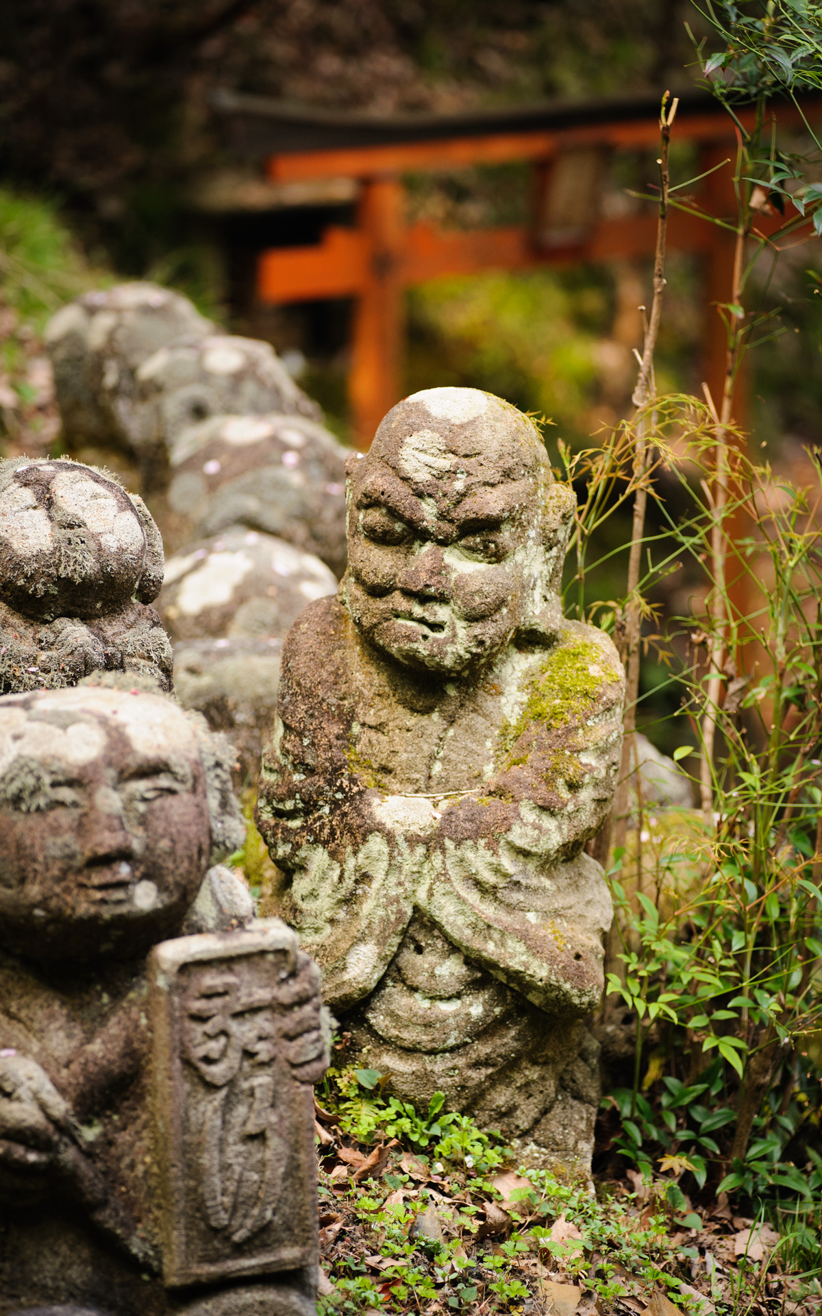
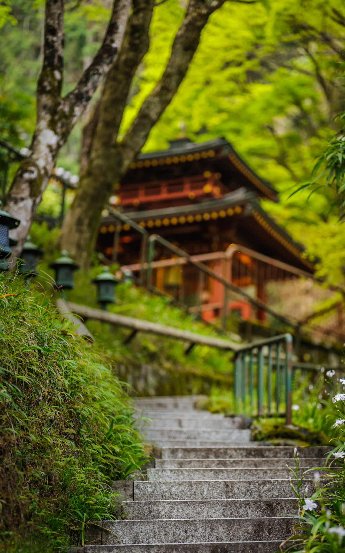
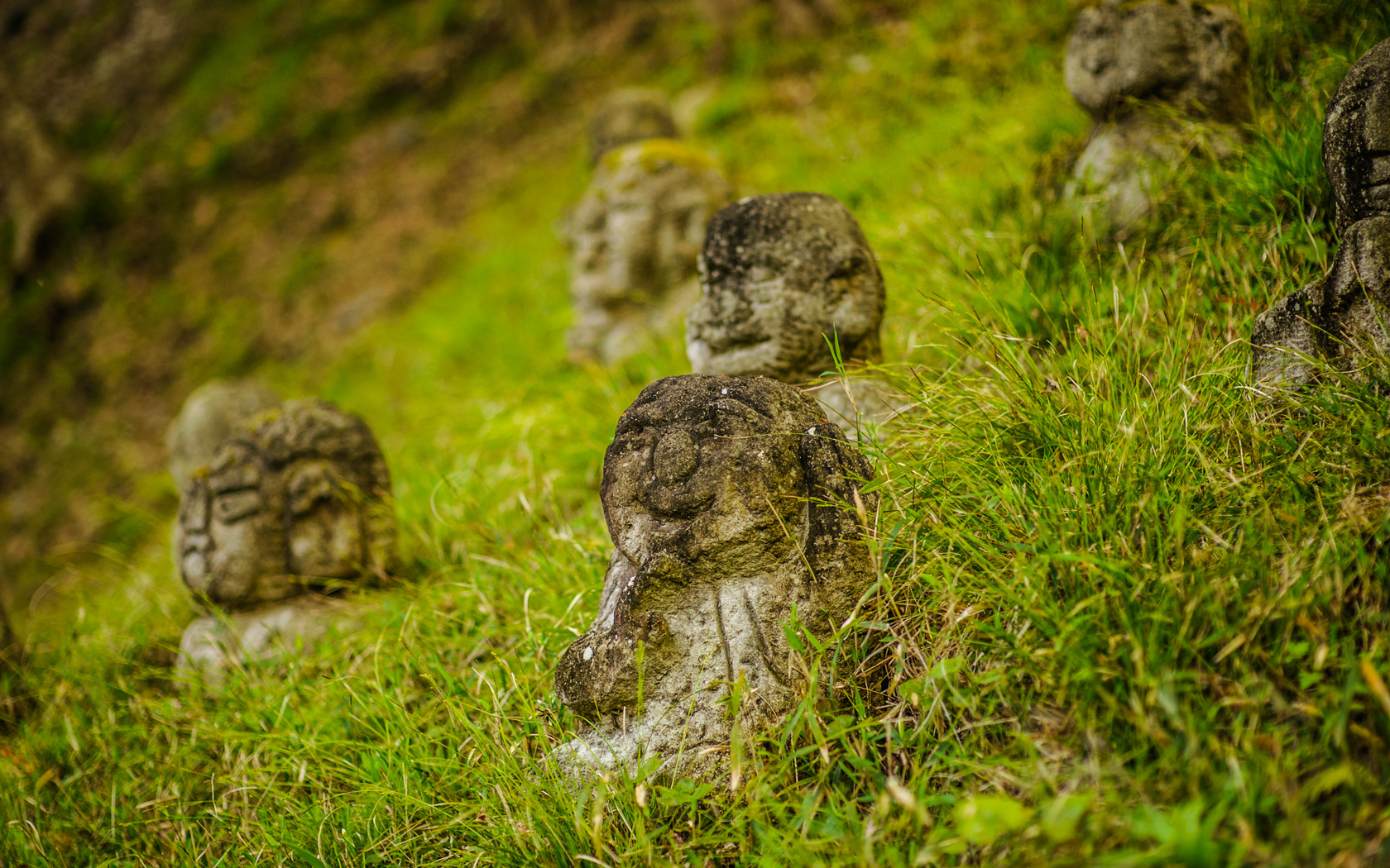
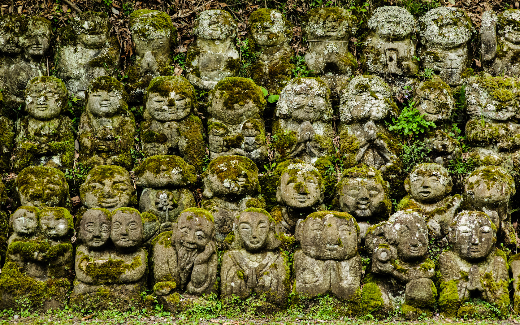
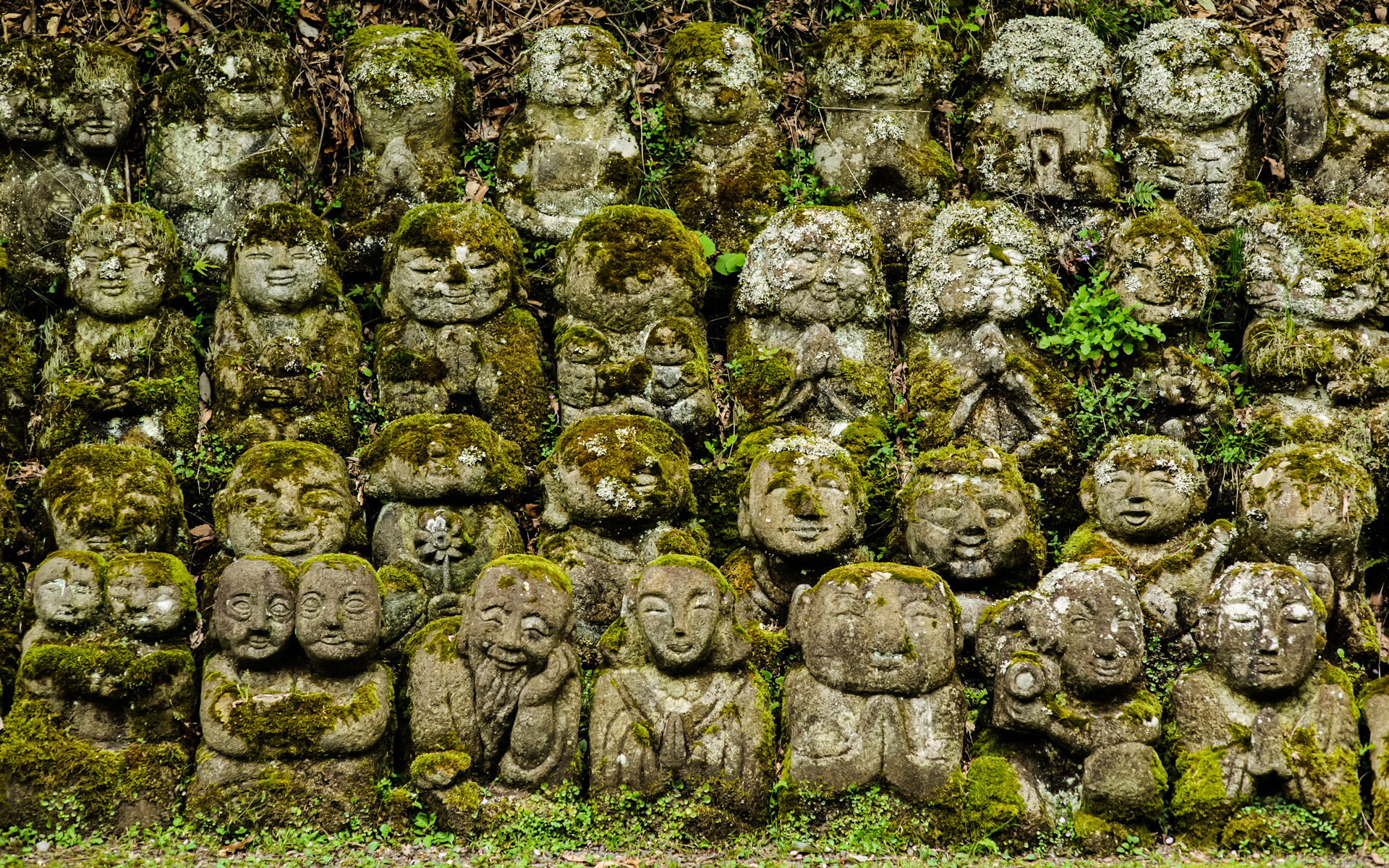
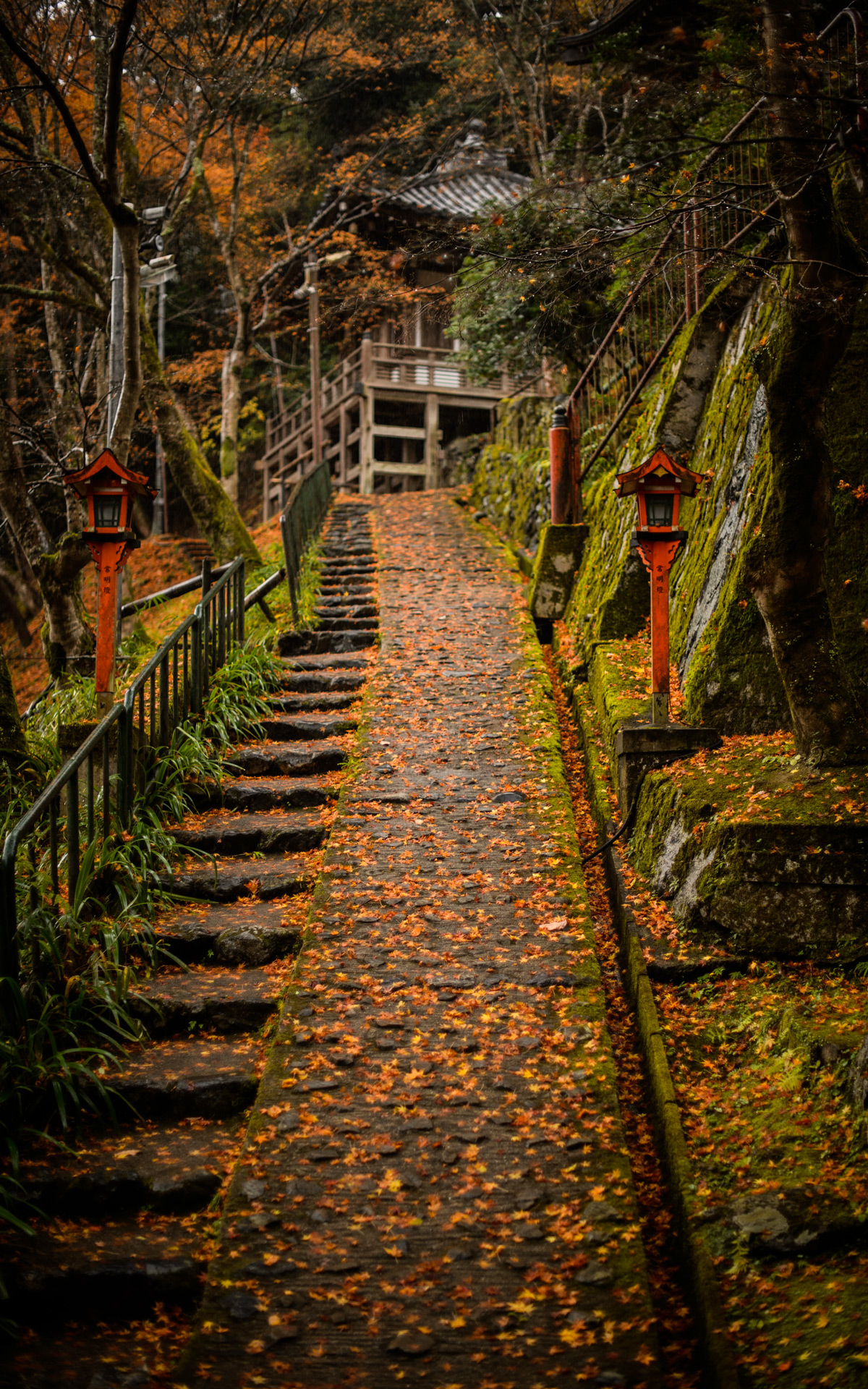
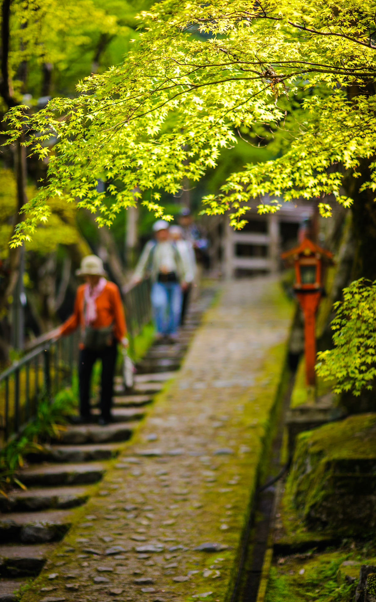
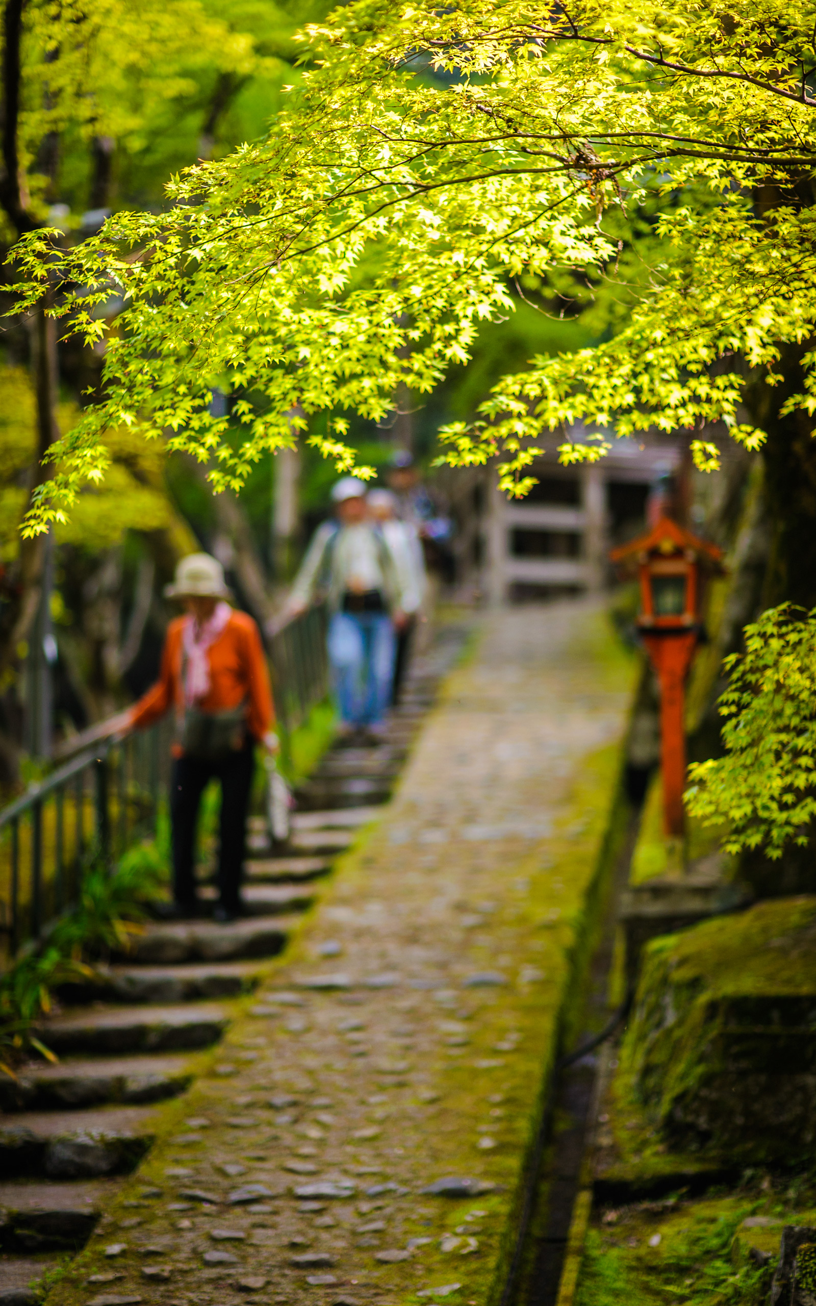
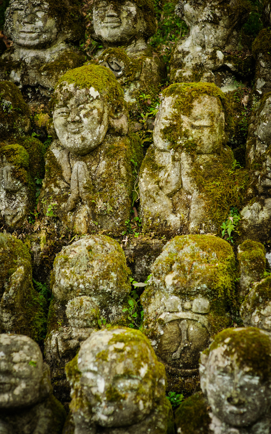
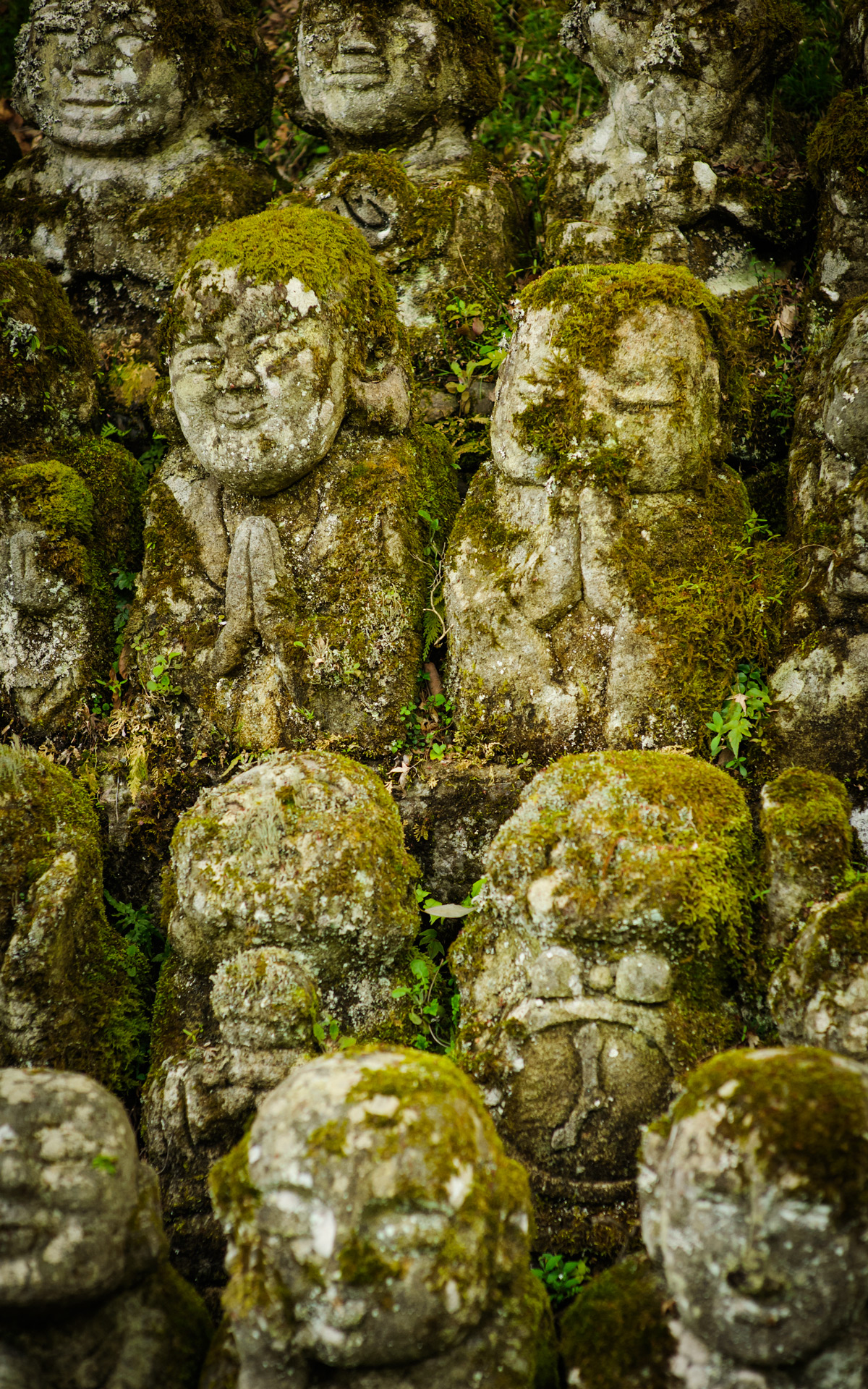
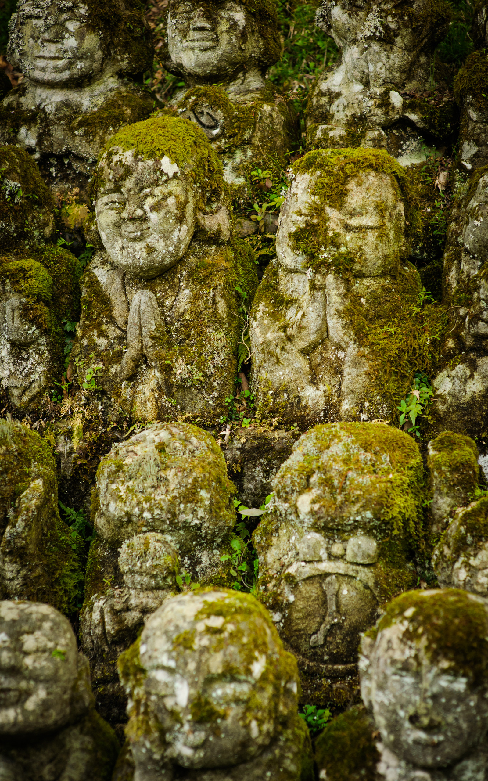