
Jeffrey E.F. Friedl's Blog, page 23
November 13, 2015
Great Day in Kyoto’s Colorful Northern Mountains, and at Strava’s Kyoto Office
Panasonic LX100 at an effective 24mm — 1/160 sec, f/5.6, ISO 200 —
map & image data — nearby photos
Autumn Colors Have Definitely Arrived
in the cold mountains of northern Kyoto
I had a nice ride the other day with Andy Clark and Michael Edwards.
While meeting up in the morning, Nigel Randell happened to stop by on his way to work...
Panasonic LX100 at an effective 24mm — 1/250 sec, f/5.6, ISO 200 —
map & image data — nearby photos
And we were approached by an American tourist passing by who saw our nice bikes and just wanted to say “hi”...
Panasonic LX100 at an effective 28mm — 1/160 sec, f/5.6, ISO 200 —
map & image data — nearby photos
Carlin Eng
in Kyoto
It turns out that he works for Strava,
the running/riding community site where your activities can be mapped and
compared to your prior efforts and to others. In the nine months since I
started cycling, I've been absolutely shocked at how motivating
Strava has been for me; upon returning from a ride, the satisfaction to see
the “PR” (personal record) badge on a particular route is something that
drives me, and I feel disappointed when I don't earn it.
Strava does have its issues, including the wild inflation of
vertical-climb numbers for a ride, prompting my May blog post “The Voodoo of Elevation Gain
and Strava”. Andy and Michael know of my data geekiness along these
lines, so when Carlin said that he was a data engineer for Strava, Michael
and Andy instinctively parted, lest they get caught in my “let's talk about
data” tractor beam. 
Actually, we just exchanged pleasantries and made sure Carlin was aware
of the plethora of wonderful mountain rides in the area. He showed us (on
the Strava App, of course) the ride he'd done the
previous day up in the northern and western mountains, a great route,
so we were satisfied that he'd at least had a good sampling. (Along the
lines of “voodoo elevation gain”, Strava says his elevation gain on that
ride was 3,890m, but it was actually 2,036m — 6,680' instead of
12,760'.)
Wishing him a good time on the temple tour he
had planned for the day, Andy, Michael, and I took off north toward Kibune.
We stopped for a photo at the same bridge that appears in the first photo on
my very first cycling-related blog post....
Panasonic LX100 at an effective 24mm — 1/100 sec, f/1.7, ISO 200 —
map & image data — nearby photos
Group Shot
on the way to Kibune (貴船)
Our route would take us over Seryo Pass (芹生峠), a climb I have done
only once, with a non-cycling friend, on a folding city-commuter bike (see
“Conquering
Kyoto’s Seryo Pass with Manu Mohan”), stopping often. So, doing it
today “for real” for the first time made me a bit apprehensive: it's long,
steep, with lots of rocks, leaves/moss, broken pavement, etc.
I made it, more than an hour faster than that first time, but still slow
going. My time of 37:06 was minute slower than Michael, and almost four
minutes slower than Andy. I'm just happy that I was able to do it without
stopping.
Halfway down the other side, Andy got a flat...
Panasonic LX100 at an effective 24mm — 1/125 sec, f/2.5, ISO 200 —
map & image data — nearby photos
Impromptu Pause
Panasonic LX100 at an effective 28mm — 1/125 sec, f/2.8, ISO 200 —
map & image data — nearby photos
Roadside Mirror
Panasonic LX100 at an effective 28mm — 1/125 sec, f/5, ISO 200 —
map & image data — nearby photos
Really Bright
bright light and dark shadows were too much for the camera sensor
Panasonic LX100 at an effective 24mm — 1/125 sec, f/7.1, ISO 1000 —
map & image data — nearby photos
Deep
deep gorge, deep colors.... sadly, doesn't come across well in the photo
Panasonic LX100 at an effective 24mm — 1/125 sec, f/5, ISO 200 —
map & image data — nearby photos
Our Tax Yen at Work
worker cleaning middle-of-nowhere street with leaf blower.
— what a fantastic waste of resources —
taken while riding at 21 kph (13 mph)
Panasonic LX100 at an effective 24mm — 1/640 sec, f/5.6, ISO 200 —
map & image data — nearby photos
Cool As Always
but deep in these northern mountains, it got downright cold.
Glad I brought a light jacket.
Panasonic LX100 at an effective 41mm — 1/250 sec, f/5.6, ISO 200 —
map & image data — nearby photos
Photo Op
Panasonic LX100 at an effective 41mm — 1/250 sec, f/5.6, ISO 200 —
map & image data — nearby photos
Posing
to me it looks like they're just checking their six,
but they were “posing” for the shot.
taken while riding at 33 kph (21 mph)
Panasonic LX100 at an effective 24mm — 1/200 sec, f/5.6, ISO 200 —
map & image data — nearby photos
Not Posing
just normal countryside riding at or below the posted speed limit
taken while riding at 34 kph (21 mph)
Panasonic LX100 at an effective 24mm — 1/125 sec, f/4.5, ISO 200 —
map & image data — nearby photos
Hamming It Up
taken while riding at 34 kph (21 mph)
Panasonic LX100 at an effective 24mm — 1/160 sec, f/5.6, ISO 200 —
map & image data — nearby photos
taken while riding at 35 kph (22 mph)
As Andy was hamming it up for the camera, I commented to Michael that Andy was leaving him in the dust. Of course Michael can't have that, so takes off like a shot....
Panasonic LX100 at an effective 24mm — 1/200 sec, f/5.6, ISO 200 —
map & image data — nearby photos
Overtake
taken while riding at 36 kph (22 mph)
Panasonic LX100 at an effective 24mm — 1/250 sec, f/5.6, ISO 200 —
map & image data — nearby photos
Panasonic LX100 at an effective 24mm — 1/200 sec, f/5.6, ISO 200 —
map & image data — nearby photos
He's Gone...
Andy knows the area particularly well, and brought us on a side road through a hidden little village...
Panasonic LX100 at an effective 47mm — 1/125 sec, f/3.5, ISO 200 —
map & image data — nearby photos
Secret Path
taken while riding at 12 kph (7 mph)
Panasonic LX100 at an effective 47mm — 1/250 sec, f/5.6, ISO 200 —
map & image data — nearby photos
Panasonic LX100 at an effective 47mm — 1/125 sec, f/2.6, ISO 320 —
map & image data — nearby photos
Incongruous Objet d'art
taken while riding at 19 kph (12 mph)
Panasonic LX100 at an effective 35mm — 1/125 sec, f/4, ISO 200 —
map & image data — nearby photos
Another Small Path
by a river with absolutely pristine crystal-clear water
Panasonic LX100 at an effective 49mm — 1/125 sec, f/2.7, ISO 320 —
map & image data — nearby photos
Insanely Steep
35%? 40%?
Andy rode up it like it was nothing; I didn't have the guts to try
Panasonic LX100 at an effective 24mm — 1/200 sec, f/5.6, ISO 200 —
map & image data — nearby photos
Back on the Main Road
taken while riding at 32 kph (20 mph)
Panasonic LX100 at an effective 24mm — 1/200 sec, f/5.6, ISO 200 —
map & image data — nearby photos
Typical Scene
just another day in Kyoto
taken while riding at 45 kph (28 mph)
Panasonic LX100 at an effective 24mm — 1/2000 sec, f/1.7, ISO 200 —
map & image data — nearby photos
Discussing the Finer Points
of art, literature, space exploration, and carbon wheels
( actually, I think they were discussing work-related research reports )
taken while riding at 34 kph (21 mph)
Panasonic LX100 at an effective 24mm — 1/1600 sec, f/1.7, ISO 200 —
map & image data — nearby photos
Perfectly Pleasant Day
taken while riding at 19 kph (12 mph)
Panasonic LX100 at an effective 24mm — 1/125 sec, f/5.6, ISO 640 —
map & image data — nearby photos
Entering a Small Village
taken while riding at 13 kph (8 mph)
Panasonic LX100 at an effective 24mm — 1/160 sec, f/5.6, ISO 200 —
map & image data — nearby photos
Sweeping Views
from a now-closed road replaced by a tunnel far below us
( it was my second time on this road, the first having been here )
taken while riding at 14 kph (8 mph)
Panasonic LX100 at an effective 27mm — 1/125 sec, f/5.6, ISO 800 —
map & image data — nearby photos
Messy Road
I guess our tax yen is not being spent enough
taken while riding at 11 kph (7 mph)
Panasonic LX100 at an effective 24mm — 1/13 sec, f/5.6, ISO 3200 —
map & image data — nearby photos
Pathetically-Shaky Photo
I'd mistakenly left the aperture stopped down too far
taken while riding at 45 kph (28 mph)
The interior of this tunnel has appeared twice before,
here and
here.
Then we stopped by the Ochiba Shrine (the aptly-named “Fallen Leaf
Shrine”)...
Panasonic LX100 at an effective 24mm — 1/125 sec, f/3.2, ISO 200 —
map & image data — nearby photos
Group Photo
at the Iwato Ochiba Shrine (岩戸落葉神社), Kyoto Japan
I've visited this shrine during the fall-foliage season many times,
first having written about it on my blog five years ago in “Carpet of Yellow
at the Iwato Ochiba Shrine, Deep in the Mountains of North-West Kyoto”,
then again three years
ago, and at about the same time, one of my first real
wigglegrams was made there.
I learned about this shrine five years ago when a friend wrote on his blog
about a bicycle trip here.
Until this year I couldn't fathom ever coming this far by bicycle, so it means something to me to be able
to come here to see the colors by bicycle. I actually came the day before as well,
on a solo ride to take in the fall colors.
Panasonic LX100 at an effective 24mm — 1/160 sec, f/5.6, ISO 200 —
map & image data — nearby photos
Quintessential Shot
at this shrine during the foliage season
On the way home I think I bonked a bit —
la petit bonk — and suddenly felt depleted about half way up the climb to Kyomi Pass. So back in the city after we all went our separate ways to return home, I stopped by a restaurant
for some All American calories...
Panasonic LX100 at an effective 24mm — 1/1600 sec, f/1.7, ISO 200 —
map & image data — nearby photos
Big Burger at Speak Easy
In the evening I treated myself to a sports massage at Dou,
the clinic run by my friend Kentaro Kataoka, who once appeared on my blog
giving an impromptu massage to another friend.
Then to cap off a great day, I met Carlin Eng, the Strava engineer I'd met that morning, for dinner. As is my habit with folks new to Kyoto, I took him to Uroko...
Panasonic LX100 at an effective 28mm — 1/40 sec, f/2.2, ISO 1600 —
map & image data — nearby photos
Cheers
Carlin Eng opens the Strava Kyoto office for a few hours
at Uroko (鱗), Kyoto Japan
I go to Uroko often, though I don't think I've mentioned it since “Facebook Engineering Opens a Satellite Office
in Kyoto”. As with that event, I shamelessly
used dinner to bribe my way into an opportunity to talk engineering and user experience directly with a
member of the company. They're probably not the appropriate person to talk to about my various concerns, I know, but it's fun and enlightening.
I really like Strava, but there are many things I wish were different, and likely would be different
if they had unlimited resources and didn't have to worry about business. I'm acquainted with at least
five billionaires that I can think of... if one of you are reading this, please buy Strava and make me
King. 


November 7, 2015
Social Ride Among Kyoto’s Fall Colors
Panasonic LX100 at an effective 31mm — 1/125 sec, f/2.8, ISO 200 —
map & image data — nearby photos
NORU Kyoto's First Social Ride
Minobu, James, Antony, Lianca, Joshua, Scotty, Tomas, Ross, Kumiko, Michael, Me
Yesterday was the inaugural social
ride hosted by NORU Kyoto. Whatever
allergy/sickness that has been plaguing me of late was in remission, so
a slow relaxing group ride seemed perfect for
me.
Panasonic LX100 at an effective 24mm — 1/125 sec, f/2.8, ISO 200 —
map & image data — nearby photos
Gathering
at NORU Kyoto
Panasonic LX100 at an effective 47mm — 1/640 sec, f/2.6, ISO 200 —
map & image data — nearby photos
Heading Out
passing in front of the Kitano Tenmangu Shrine (北野天満宮)
Panasonic LX100 at an effective 24mm — 1/1000 sec, f/2, ISO 200 —
map & image data — nearby photos
Ross and Tomas
taken while riding at 18 kph (11 mph)
This was my first ride with Tomas, the fastest rider in the group.
Although I'd not ridden with Tomas before, we'd chatted at other events and
share an interest in photography and programming. I was happy that my first
ride with him was a slow social group ride, allowing me to keep up and
chat.
To give a sense of Tomas' speed, his time on my benchmark Hanase Pass
climb is less than 24 minutes, which seems inhumanly fast to me. My best time is more than 32 minutes.
Panasonic LX100 at an effective 52mm — 1/400 sec, f/2.8, ISO 200 —
map & image data — nearby photos
Making Our Way Out of the City
nature and mountains are never very far away when in Kyoto
Panasonic LX100 at an effective 46mm — 1/125 sec, f/5.6, ISO 200 —
map & image data — nearby photos
Antony Chugging Up In The Mountains
A few people were new to the group, including Antony who had never
really ridden in the mountains. His showing up in street clothes without experience largely paralleled my own first ride, except his
bicycle was much less appropriate for the mountains than mine, and this ride was going to be
longer than what I did. He had guts. It would be interesting to see how far he got.
Panasonic LX100 at an effective 31mm — 1/125 sec, f/5.6, ISO 200 —
map & image data — nearby photos
Joshua and Lianca
heading up to Kyomi Pass (京見峠)
taken while riding at 14 kph (8 mph)
Panasonic LX100 at an effective 50mm — 1/125 sec, f/2.7, ISO 640 —
map & image data — nearby photos
Rush Hour
Lots of hikers making their way up as well
taken while riding at 16 kph (10 mph)
Panasonic LX100 at an effective 38mm — 1/125 sec, f/2.4, ISO 400 —
map & image data — nearby photos
Making It Look Easy
James on his first ride with the group
taken while riding at 11 kph (7 mph)
Panasonic LX100 at an effective 75mm — 1/125 sec, f/4, ISO 200 —
map & image data — nearby photos
Scruffy Ross
at Kyomi Pass (京見峠)
I was about to have you compare the photo above to “clean-shaven
Ross”, but it turns out he's not as clean-shaven in that pic either.
We took some group photos near Kyomi Pass, one of which opens this post.
I Photoshop'd myself into the copy seen above, from a separate photo
that Joshua took. It turns out that I was standing a bit closer to the
camera than anyone else, so my height was exaggerated to the point of
making me look grotesquely big. So, I took the liberty to shrink myself to
a more contextually-balanced size.
Panasonic LX100 at an effective 24mm — 1/125 sec, f/1.7, ISO 200 —
map & image data — nearby photos
Heading Down
A bit of “motion blur” adds life to cycling photos, but I had incessant problems with blur and focus all day 
Our route, a clockwise version of Kyoto's “Heart Loop”
ride, next brought us to Mochikoshi Pass, which from this
direction is neither long nor challenging.
Panasonic LX100 at an effective 24mm — 1/125 sec, f/2.5, ISO 200 —
map & image data — nearby photos
Gathering at the Top
Mochikoshi Pass (持越峠)
I continued down early to set up to take photos of others coming down, settling for a spot with a small splash of
color because it didn't seem like the rest of the (very steep) way down
would offer a better background. Sadly, I was wrong and it would have been much better had
I continued, but I
guess it doesn't matter because most of the photos didn't come out.
I think I just don't
know how to use this small
camera I bought for use while cycling. I'll
bring my Nikon D4 on the next social outing.
Panasonic LX100 at an effective 30mm — 1/80 sec, f/2.2, ISO 200 —
map & image data — nearby photos
Ross Leads The Way Down
Panasonic LX100 at an effective 28mm — 1/80 sec, f/2.1, ISO 200 —
map & image data — nearby photos
Antony and James
too fast to capture
Panasonic LX100 at an effective 28mm — 1/125 sec, f/2.1, ISO 400 —
map & image data — nearby photos
“Oddly Wrong” Joshua
The bad Photoshop job above is the result of a joking promise I made to Joshua to “make him look fast” by adding
motion blur. He'd come around the corner slowly, and did a track stand
in front of me to pose for the photo. Sadly, I'm no good at this kind of Photoshop, so it would have been easier to
make him look fast by just asking him to go back and actually be fast (something he's more than capable of doing,
as an exhausted me found out on my first ride with him).
Panasonic LX100 at an effective 29mm — 1/125 sec, f/2.8, ISO 200 —
map & image data — nearby photos
Heading Back Toward Town
closing out the first half of the ride
taken while riding at 30 kph (18 mph)
Panasonic LX100 at an effective 29mm — 1/125 sec, f/2.8, ISO 200 —
map & image data — nearby photos
Typical Japanese Country Scene
beautiful nature, utility pole, cinderblock wall, cyclists
10:54am - taken while riding at 28 kph (17 mph)
Panasonic LX100 at an effective 29mm — 1/125 sec, f/2.1, ISO 200 —
map & image data — nearby photos
Another Typical Japan Scene
old Japanese architecture, Michael looking fast and calm
taken while riding at 32 kph (20 mph)
Panasonic LX100 at an effective 56mm — 1/125 sec, f/3.2, ISO 200 —
map & image data — nearby photos
Not Quite So Typical
James and Antony roll past an old farmstead
Panasonic LX100 at an effective 24mm — 1/125 sec, f/1.7, ISO 250 —
map & image data — nearby photos
Color-Coordination Par Excellance
this was my first ride with Nishimura-san
taken while riding at 57 kph (35 mph)
Panasonic LX100 at an effective 32mm — 1/125 sec, f/2.2, ISO 200 —
map & image data — nearby photos
Lovely Corrugated-Metal Background
I missed a background of rich autumn colors by a couple of seconds
taken while riding at 35 kph (22 mph)
The biggest problem I face trying to capture the photos I want (besides
the need to avoid crashing) is getting far enough back to include all that
I want while at the same time excluding unsightly stuff from the
background. The shot of Tomas above was just a bit too late to capture what felt to be the
perfect combination, and I ended up with dilapidated corrugated metal for my background.
Undaunted, I tried again later on the next little climb...
Panasonic LX100 at an effective 28mm — 1/125 sec, f/3.5, ISO 200 —
map & image data — nearby photos
A Tomas In Its Natural Environment
taken while riding at 20 kph (12 mph) up the Ichihara Byass
Panasonic LX100 at an effective 24mm — 1/125 sec, f/4, ISO 200 —
map & image data — nearby photos
Fake Aero
taken while descending at only 30 kph (19 mph)
( if he'd actually been going fast, I'd not have been able to take the pic )
Panasonic LX100 at an effective 24mm — 1/125 sec, f/3.2, ISO 200 —
map & image data — nearby photos
taken while riding at 37 kph (23 mph)
Panasonic LX100 at an effective 24mm — 1/125 sec, f/4.5, ISO 200 —
map & image data — nearby photos
Convenience-Store Stop
at about the halfway point
Panasonic LX100 at an effective 75mm — 1/125 sec, f/3.2, ISO 200 —
map & image data — nearby photos
Village Detour
we popped up to the top of a short hill overlooking a village
Panasonic LX100 at an effective 24mm — 1/125 sec, f/4, ISO 200 —
map & image data — nearby photos
View of the Village
Panasonic LX100 at an effective 46mm — 1/125 sec, f/3.2, ISO 200 —
map & image data — nearby photos
Heading Down Through the Village
taken while riding at 20 kph (12 mph)
We then did the last climb of the day, to Ebumi Pass (江文峠), then down the other side to
the large but picturesque village of Ohara (大原).
Panasonic LX100 at an effective 24mm — 1/125 sec, f/9, ISO 500 —
map & image data — nearby photos
Typical Ohara Scene
Panasonic LX100 at an effective 46mm — 1/500 sec, f/2.6, ISO 200 —
map & image data — nearby photos
Me
photo taken by a passer-by
While I'd stopped to take photos of the fields, the others had gone to a farmers' market to
partake of what the fields produced...
Panasonic LX100 at an effective 24mm — 1/125 sec, f/3.5, ISO 200 —
map & image data — nearby photos
At a Farmer's Market
Panasonic LX100 at an effective 24mm — 1/125 sec, f/4, ISO 200 —
map & image data — nearby photos
Bicycle Parking
The return to Kyoto from Ohara is downhill the whole way, which I'm sure Antony appreciated.
Having ridden over three passes on that heavy city bike, I'm sure he was exhausted.
Panasonic LX100 at an effective 24mm — 1/125 sec, f/3.2, ISO 200 —
map & image data — nearby photos
Downhill All the Way
taken while riding at 41 kph (26 mph)
Panasonic LX100 at an effective 25mm — 1/125 sec, f/5.6, ISO 200 —
map & image data — nearby photos
Back in the City
passing through the Shokoku-ji Temple (相国寺) complex
Antony, who lives near me, joined me for the ride home after coffee and cake at NORU Kyoto.
Panasonic LX100 at an effective 24mm — 1/320 sec, f/5.6, ISO 200 —
map & image data — nearby photos
Feeling Satisfied
after a long ride in the mountains on a bike not meant for the mountains
Panasonic LX100 at an effective 24mm — 1/250 sec, f/5.6, ISO 200 —
map & image data — nearby photos
Lovely Early-Autumn Day in Kyoto
In the end my ride was about 66km (41 miles).
Here it is on my cycling heatmap
and at Strava.
A great day with great folks.
Update: here's a short video from the ride.
November 6, 2015
A Heatmap of All My Cycling In and Around Kyoto
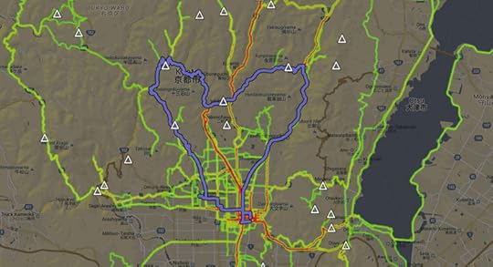
One “Kyoto Heart Loop” Ride
highlighted among all the cycling I've done this year
私のサイクリング経験の「ヒートマップ」。よく行く所は赤くなる。
I built a “heatmap” showing all the places I've ridden my bicycle since
getting into cycling earlier this year. I thought it might be interesting
for visitors researching rides they might want to try.
It's here: “Heatmap of Jeffrey's Cycling in Kyoto”.
At the moment it includes data on 76 rides, with areas of yellow and red
being more-often visited roads.
Clicking anywhere I've ridden brings up a list of rides that passed the area...
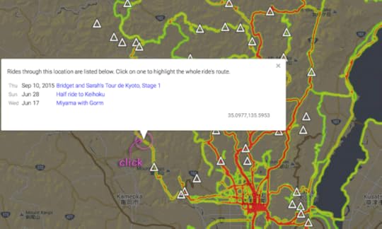
In the example above, I'd ridden the clicked-on road three times. Clicking then on the most-recent ride name
highlights the whole ride on the map, and info about the ride shows up at the top:

The info at the top includes a link for the activity at Strava, and any
related blog posts or Facebook photo albums.
Mountain passes are marked with a triangle icon; clicking on one brings up its name and elevation...

You can turn off the mountain-pass display by clicking on the triangle icon in the upper-right corner of the page.
I don't know whether this will actually be interesting for anyone
besides me, but since I made it, I thought I'd share it.
(Thanks to Google for providing the tools that do all the hard work of mapping and display.)
October 28, 2015
Bridget and Sarah’s Tour-de-Kyoto, Stage 2
Panasonic LX100 at an effective 24mm — 1/3200 sec, f/4, ISO 200 —
map & image data — nearby photos
Getting Ready for the Day's Photos
Sarah Knights, at the entrance to the Kurama Temple, Kyoto Japan
last month
Only a month and a half late, I'm finally getting around to posting
about Stage Two of Bridget and Sarah's Tour de Kyoto. These two
visitors from Australia were introduced in Bridget and Sarah’s
Tour-de-Kyoto, Part 1 and Part 2.
Panasonic LX100 at an effective 24mm — 1/640 sec, f/4.5, ISO 200 —
map & image data — nearby photos
Photographer's Crouch
as she photographs Manseki Kanemitsu
Panasonic LX100 at an effective 25mm — 1/400 sec, f/4.5, ISO 200 —
map & image data — nearby photos
The morning had revealed that Sarah's tire did not survive the previous
day's puncture-festival, but Manseki kindly loaned her a wheel, so she
could ride for the day.
These pictures at the entrance to the Kurama Temple were on our way to
the first big climb of the day, Kyoto's big “Hanase Pass”, which
rises 500m over 5.8km for an average grade of 9%. Now that I'm used to it
it's not that tough..... unless I try to go fast, which makes anything tough.
I was hoping go fast. At least, I was hoping to stick with Bridget on the climb, but
she left me right away and I did not see her for most of the climb. She went on to capture the
Queen of the Mountain ranking for that climb, meaning hers was
the best time among all females registered with Strava. She beat my best
time by more than a minute, and I was slower than my best by half a minute.
Sarah, who is not a climber as much as a downhill and flat sprinter, captured
the 5th best overall women's time.
Kumiko was able to complete the climb, making it her first ascent of Hanase:
Panasonic LX100 at an effective 24mm — 1/250 sec, f/5.6, ISO 200 —
map & image data — nearby photos
Kumiko Triumphant Arrival
Hanase Pass (花背峠)
The climb is well within her abilities, but I think she had a mental block against it because she had to abandon
her first attempt, which she'd made when first getting used to riding while clipped in
(something that caused me much trepidation
until I got used to it).
Panasonic LX100 at an effective 33mm — 1/400 sec, f/5.6, ISO 200 —
map & image data — nearby photos
High Fives
Panasonic LX100 at an effective 37mm — 1/160 sec, f/5.6, ISO 200 —
map & image data — nearby photos
Manseki Arrives
he was riding a bike with gearing that made the climb much tougher than it needed to be
( but the bike looked good, which was the important thing
October 19, 2015
The New Bike Is Fast; I’m Just Going Along For The Ride
Panasonic LX100 at an effective 46mm — 1/100 sec, f/10, ISO 500 —
map & image data — nearby photos
Southern View from Onyu Pass
is starting to show a bit of color
I took a long bicycle ride into the mountains north of Kyoto on Saturday. It was my first long outing since recovering from what I thought was a mild but
persistent cold, but turned out to be a respiratory-tract infection. Once I got
antibiotics, I felt better almost right away.
Since I was mostly out of commission for three weeks, I knew I was out
of shape and wouldn't be particularly fast, but at the same time, I was on
my new bike, which
seems to let me go faster for the same effort, so in the end I didn't know
which competing effect would win.
To start my ride, I joined Andy Clark on a trip up to Hanase Pass, 710m
higher than where I live, and the first big climb I ever
did, so it has a special place in my heart. It was my first to try it
with the new bike, so I hoped I could shatter my old record, but I could
feel right away that I just didn't have the energy. Three weeks being sick
had just made me too soft.
And it's just as well that I wasn't on track for a killer time, because
I stopped to assist a pair of boys — maybe 10 or 11 years old —
that I came upon on the deserted mountain road looking at a big map book of
Japan, wondering where they were. Wanting to go to Hanase Pass, they were on the correct
road, but didn't know how far along they were. I helped them with directions and
info on where to get beverages. According to my tracklog, I spent 1:54 with them.
A young, fast Japanese cyclist had passed me not long before I came
across the boys... I wonder why he didn't stop to help them. Even if they
were not standing looking at a map, I'd at least touch base with kids so
young in such a place.
Anyway, Andy and I made our slow way up to the pass and all the way down the other side.
Andy didn't have time for a longer ride, so we parted ways and he retraced his steps.
I was dead tired, but from being out of shape and not from the cold, so
I wanted to continue along, slowly, to see where the day would take me.
It first took me north to Nomi Pass, where I met a construction worker at the top. He told me to take
care with my descent, because there would be some big construction equipment moving up. He wasn't kidding.
Panasonic LX100 at an effective 24mm — 1/1000 sec, f/2.8, ISO 200 —
map & image data — nearby photos
Wide Load
the huge backhoe almost fills the width of the road
and it looks like it was an ordeal making this hairpin turn
Emerging from the mountains to the edge of a small village, you're
greeted with a quintessential old farmhouse that just naturally begs to be
photographed:
Panasonic LX100 at an effective 25mm — 1/80 sec, f/10, ISO 250 —
map & image data — nearby photos
The same house covered in snow was seen in this photo
from my first big ride in February, and in the spring
when recreating that first ride three months later.
Panasonic LX100 at an effective 27mm — 1/80 sec, f/10, ISO 250 —
map & image data — nearby photos
Another House in the Village
with their rice at right, hanging to dry like this
The front of the house looks like a field of weeds...
Panasonic LX100 at an effective 24mm — 1/60 sec, f/10, ISO 320 —
map & image data — nearby photos
... so it's hard to believe it's the same house that
was fronted with a lovely sea of flowers
when I went by two months ago.
Panasonic LX100 at an effective 25mm — 1/125 sec, f/10, ISO 800 —
map & image data — nearby photos
A Bit of Fall Colors
at this house in the village
Panasonic LX100 at an effective 24mm — 1/1600 sec, f/1.7, ISO 200 —
map & image data — nearby photos
Mud-Roofed Storage Building
taken while cycling at 23 kph (14 mph)
Normally the roof is finished and painted, like this one.
Panasonic LX100 at an effective 24mm — 1/125 sec, f/5.6, ISO 200 —
map & image data — nearby photos
Small Stream
from a bridge crossing over it
Panasonic LX100 at an effective 24mm — 1/500 sec, f/6.3, ISO 200 —
map & image data — nearby photos
Looking The Other Way
On the long and pleasant Route 783 up to the start of Onyu Pass, there's
a turnoff that I'd been wanting to check out....
Panasonic LX100 at an effective 24mm — 1/200 sec, f/8, ISO 200 —
map & image data — nearby photos
Unassuming Turnoff
looking from the north
When peeking in, it dives up the mountain in an inviting way:
Panasonic LX100 at an effective 67mm — 1/125 sec, f/8, ISO 3200 —
map & image data — nearby photos
“You Can't Shortcut Through Here”
the sign at left
The road is not marked on Google Maps (and it's on
OpenStreetMap.org only because I added it), but looked inviting on
Google Earth. But with the aforementioned dead tiredness, I paused for a
while and took a nap, using a log by the side of the road as a pillow...
Panasonic LX100 at an effective 38mm — 1/80 sec, f/8, ISO 640 —
map & image data — nearby photos
Nap Time
I didn't have the slightest worry that a car would come along... ever
After about half an hour, I took off up the unknown road. It turns out
to be about 1.4km (0.9mi) long, rising at an average grade of 10.6%, ending
unceremoniously into the face of the mountain:
Panasonic LX100 at an effective 24mm — 1/60 sec, f/8, ISO 200 —
map & image data — nearby photos
Road to Nowhere
the end of a nice 1.4km 11% climb
To be clear, this is not a road that had been sealed off by a rockfall... the road construction just stopped here.
Also, unlike the Bridge
to Nowhere that I posted about nine years ago, it doesn't appear that
this is an ongoing project that I just happen to have caught in this
useless state.
The road does not appear to have any reason to exist... there's no dam
or cell tower it's allowing access to, and it's not supporting forestry or
farming or anything else I could see. It's just a beautiful road
painstakingly cut into a very steep mountain, never to be used. I can only
imagine what the construction workers thought as they painted the
highly-reflective white lines right up to the blunt rockface.
The best I can guess is that the road was intended to be continued over
the mountain to join up with where Route 783 has looped back down, cutting
off a 14km-segment of Route 783 for those just wanting to move east. If
that's the case, the project seems to have been abandoned.
Anyway, it makes for a nice 150m climb. The road surface is nice for all
but a short section where it's become warped and buckled, though it's
littered with rocks here and there. On the climb I'd concentrated on just
not giving up, but for the ride down I pulled out the camera.
Panasonic LX100 at an effective 28mm — 1/80 sec, f/8, ISO 400 —
map & image data — nearby photos
Road Stuck Onto The Side of the Mountain
lots of effort for little apparent gain
Panasonic LX100 at an effective 24mm — 1/60 sec, f/10, ISO 400 —
map & image data — nearby photos
Great View
okay, I guess a great view is one apparent gain
Panasonic LX100 at an effective 41mm — 1/80 sec, f/10, ISO 250 —
map & image data — nearby photos
Typical Section of Road
cut through the mountain, lightly littered with rocks
I ended up making a segment for the climb on Strava. Unsurprisingly, I'm the only one who's done this section of road before....
Back on the country lane heading north, this is a typical scene when coming across the occasional house:
Panasonic LX100 at an effective 24mm — 1/60 sec, f/9, ISO 200 —
map & image data — nearby photos
Fenced Off
to keep animals out of their gardens
Panasonic LX100 at an effective 75mm — 1/800 sec, f/2.8, ISO 200 —
map & image data — nearby photos
Getting Ready for the Winter
I had the pleasure to chat with Neil Holt, whom I came across as he road south...
Panasonic LX100 at an effective 24mm — 1/125 sec, f/9, ISO 200 —
map & image data — nearby photos
Neil Holt
always seem to have a smile
Coincidentally, I was with Neil
the last time I'd been on this road. It was nice to have a little chat. He told me about a back road that I would end up taking later on my ride.
After our chat, I continued north, plodding up to the 839m elevation of Onyu Pass, where someone who had arrived
by car kindly took my photo for me...
Panasonic LX100 at an effective 28mm — 1/80 sec, f/16, ISO 1250 —
map & image data — nearby photos
Gasless
was how my body felt the whole time
Onyu Pass (おにゅう峠)
Panasonic LX100 at an effective 75mm — 1/125 sec, f/8, ISO 400 —
map & image data — nearby photos
View North to Obama
relatively clear for Onyu Pass, but still hazy
The view to the south, where I'd come from, leads this post.
The two other times I'd made the climb up here, I paused often while descending to take photos, but this time I just
went directly down at a pretty fast clip. It was fun.
I thought that there was no commerce for many miles, so I was surprised to find a cafe in the middle of nowhere. It turns out that they're open only on weekends and holidays, from 9am to 3pm...
Panasonic LX100 at an effective 24mm — 1/125 sec, f/5, ISO 200 —
map & image data — nearby photos
Sankirai Cafe (山帰来)
They didn't have any food, just coffee, but the proprietor took pity on my hunger and
gave me a bunch of chocolate and cookies...
Panasonic LX100 at an effective 28mm — 1/5 sec, f/13, ISO 1600 —
map & image data — nearby photos
Trying To Refill The Gas Tank
Feeling a bit refreshed, and filling my water bottles at an outside
fountain near the cafe, I headed east toward Route 367, about 20 kilometers
away. It was my first time to head that way, previously always returning
due south the way I'd come. I didn't know what to expect, but hoped it'd be
faster and less hilly than the route I knew. I was really tired and
daylight was limited.
I eventually came to a turnoff that Neil had told me about. Two days prior he'd seen that a friend had “discovered” an
old back road that Neil had not known about. It sounded interesting, so
I decided to give it a try.
Panasonic LX100 at an effective 24mm — 1/125 sec, f/4, ISO 200 —
map & image data — nearby photos
The Nondescript Turnoff
Panasonic LX100 at an effective 40mm — 1/80 sec, f/9, ISO 500 —
map & image data — nearby photos
View From Its Bridge
Panasonic LX100 at an effective 24mm — 1/125 sec, f/9, ISO 1600 —
map & image data — nearby photos
Immediate Fork
just after the bridge
Both roads have feeble “road closed” signs. The one to the right was not on my map, so I took the one to the left.
Looking later on Google Earth, the one to the right appears to be similar to the road-to-nowhere one I road earlier in the day.
I'll have to check it out next time I'm in the area.
The road ended up being a pretty standard deep-country mountain road, mostly clear but with sections of
moss and muck that would make it really unappealing for bicycles when wet.
Panasonic LX100 at an effective 62mm — 1/125 sec, f/4, ISO 800 —
map & image data — nearby photos
Mossy
Panasonic LX100 at an effective 46mm — 1/125 sec, f/4, ISO 400 —
map & image data — nearby photos
Pretty
Panasonic LX100 at an effective 24mm — 1/125 sec, f/4, ISO 2000 —
map & image data — nearby photos
Short Section of Muck
taken while cycling at 20 kph (13 mph)
Panasonic LX100 at an effective 52mm — 1/100 sec, f/4, ISO 320 —
map & image data — nearby photos
Debris Here and There
Panasonic LX100 at an effective 24mm — 1/60 sec, f/4, ISO 500 —
map & image data — nearby photos
Ohikodani Pass (大彦谷峠)
The western approach that I took ended up being 3.4km with an average
grade of 7%. Not too challenging. I made a segment
for it on Strava, and I'm the only one to have ridden it so far. The friend who had ridden two days prior had come from the other direction, and
so far he's the only one to have ridden that segment. I guess the road is not very popular compared to its alternative.
I've never taken the alternative so I can't compare, but on a dry day this traffic-less road seems nice.
A trail-running path cuts across the pass, reminding me that I'm a wimp to use wheels...
Panasonic LX100 at an effective 24mm — 1/60 sec, f/4, ISO 1000 —
map & image data — nearby photos
Onward and Upward
For my part, hours away from home with not that much daylight left, I headed down.
I went much faster than I should have, often hitting rocks that I didn't see among the leaves. I was sort of surprised that I didn't get a puncture, until I got a puncture.
Panasonic LX100 at an effective 24mm — 1/30 sec, f/8, ISO 3200 —
map & image data — nearby photos
First Puncture on the New Bike
It was my first time to change a tire when it wasn't pouring rain with
the wheel covered in grime. It was lovely, and when I was done my hands
were still clean.
Panasonic LX100 at an effective 24mm — 1/100 sec, f/1.7, ISO 200 —
map & image data — nearby photos
Leaving The Closed Road
it's not locked... it's just kept closed to keep animals away from the village
Panasonic LX100 at an effective 75mm — 1/250 sec, f/5.6, ISO 200 —
map & image data — nearby photos
Sun Dipping Behind the Mountains
Panasonic LX100 at an effective 24mm — 1/160 sec, f/5.6, ISO 200 —
map & image data — nearby photos
Just 47km (29mi) Farther To Kyoto
taken while cycling at 24 kph (15 mph)
Now on the substantially-larger Route 367, I had a straight-forward
ride home. I was tired and drained and just wanted to be home, but
I stopped at the first cafe I came to just to get some calories. I'd brought plenty, but had long since eaten it all.
Panasonic LX100 at an effective 29mm — 1/125 sec, f/2.1, ISO 200 —
map & image data — nearby photos
Wing Cafe
I was really in a rush, so consulted with them on what would be the fastest to prepare, and ordered
a “mixed sandwich”. But then I noticed cake behind the counter, and ordered that as well, knowing it'd be fast.
Here's how it arrived:
Panasonic LX100 at an effective 37mm — 1/125 sec, f/2.4, ISO 2000 —
map & image data — nearby photos
Very Special Grape
It came garnished with a grape, which I popped into my mouth the moment I put the camera down. It was the most delicious food ever created by man or nature. Two bites later, the cake was gone.
Panasonic LX100 at an effective 35mm — 1/80 sec, f/2.3, ISO 1000 —
map & image data — nearby photos
“Mixed Sandwich”
nondescript mostly-bread sandwich; common in Japan
Panasonic LX100 at an effective 24mm — 1/60 sec, f/1.7, ISO 800 —
map & image data — nearby photos
Pleasant Interior
that I didn't stick around to enjoy
After this I headed straight home on Route 367.
As I discussed in a recent post,
Route 367 has a bunch of tunnels that are safer to avoid, but at this point I valued
speed pretty highly... I just wanted to be home. I have a very bright tail light, so
I don't actually feel the tunnels are all that dangerous, so I took them all.
The closed and broken road that one tunnel bypasses, that I wrote about
the other day, would have been much easier today because the water level
was down. I had a nice view of it from the bridge between tunnels.
Panasonic LX100 at an effective 75mm — 1/125 sec, f/2.8, ISO 1000 —
map & image data — nearby photos
compare to this scene a month ago
Panasonic LX100 at an effective 35mm — 1/80 sec, f/2.3, ISO 500 —
map & image data — nearby photos
Mostly Dry
compared to this
Much of the long trip home is uphill, but it's worth it for the fast
downhill sections, which I love. On one section (discussed
here) my on-bike speed indicator said that I reached 78kph (48mph), so
that was a new record for me. I've got to thank Andy Clark for that... on
the descent together from Hanase that morning, he offered comments on some
of my un-aerodynamic ways he'd noticed. Using his advice, I was able to
break 70kph on four different sections of road on the way home.
So, that was that. By the time I got home, I was the most tired I'd been
after a bike ride since returning home after my first big ride in
February.
I uploaded my data to Strava, and immediately saw which of the competing
factors (out-of-shape slowness vs. new bike speed) was most
impactful. All the yellow marks at the left edge told me that the bike is
really fast, even if I'm slow:

Wow
New bike was fast; I got to go along for the ride
The yellow icons shaped like crowns mean that I'm the fastest male to have done the segment,
but in these cases it's because I'm the only male to have done the segment, so they don't mean anything. But the other icons, with “PR” (Personal Record) in them, mean that I did it faster this time than any time before. The two near the top that have no mark are when I had stopped along the way. I was tired the whole time, and felt
very slow, so these results just show how correct everyone was who said a new bike would be fast.
On my personal benchmark hill climb, the climb to Hanase
Pass, despite having stopped to help the kids for a couple of minutes, I still beat my personal best by more than two minutes. I wouldn't have
broken 30 minutes even if I hadn't stopped, but I think that'll be my
personal goal for the near term. According to Strava, folks have done it in
20 minutes, which is just unfathomable to me.
So that was my Saturday. Now it's Tuesday and I'm mostly recovered, I hope. Gotta' get back into form....
October 18, 2015
Last Month’s Particularly Epic Cycling Adventure, Part 2
This post picks up from “Last Month’s
Particularly Epic Cycling Adventure, Part 1”, about a ride that I took with Nigel Randell and Andy Clark
a month ago.
Part 1 ended with us
having reached Minetoko Pass (elevation 888m / 2,900') on a long gravel
road.
Panasonic LX100 at an effective 32mm — 1/200 sec, f/2.2, ISO 200 —
map & image data — nearby photos
Heading Down
The descent down the other side was often very rough, and the rain continued, but it was worth it
because the views and general scenery were often gorgeous.
Panasonic LX100 at an effective 24mm — 1/125 sec, f/5, ISO 200 —
map & image data — nearby photos
Panasonic LX100 at an effective 24mm — 1/500 sec, f/1.7, ISO 200 —
map & image data — nearby photos
Panasonic LX100 at an effective 30mm — 1/125 sec, f/4, ISO 200 —
map & image data — nearby photos
Panasonic LX100 at an effective 38mm — 1/80 sec, f/13, ISO 640 —
map & image data — nearby photos
Panasonic LX100 at an effective 41mm — 1/125 sec, f/2.8, ISO 200 —
map & image data — nearby photos
“Soft Shoulder”
with a speed limit (12mph) that I'm sure we exceeded
SC-04E at an effective 31mm — 1/310 sec, f/2.2, ISO 100 —
map & image data — nearby photos
photo by Nigel Randell
One thing that set this descent apart is that the forest it traversed seemed to be mostly original virgin wood,
and not farmed ceder seen almost everywhere else. The ample deciduous trees should make this path spectacular next month.
Panasonic LX100 at an effective 40mm — 1/80 sec, f/2.5, ISO 500 —
map & image data — nearby photos
A Nigel in the Wild
can blend into the natural surroundings to the point of near invisibility
Panasonic LX100 at an effective 24mm — 1/125 sec, f/5, ISO 200 —
map & image data — nearby photos
Panasonic LX100 at an effective 24mm — 1/125 sec, f/2.5, ISO 200 —
map & image data — nearby photos
Construction in the Middle of Nowhere
flood-control stuff
SC-04E at an effective 31mm — 1/25 sec, f/2.2, ISO 100 —
map & image data — nearby photos
I Got a Flat
photo by Nigel Randell
There was a sharp edge across the road where the pavement restarted, and I hit it too quickly and got a pinch flat,
only the second flat I've gotten since starting to ride earlier this year. Like the first time, it was raining as I changed the tire.
Eventually the road returned to civilization, only to be blocked by a padlocked gate.
Panasonic LX100 at an effective 24mm — 1/125 sec, f/2.5, ISO 200 —
map & image data — nearby photos
I don't understand how a public road can be suddenly gated like this... there was nothing to stop us getting
here, so why not let us continue?? We certainly weren't going to spend the hours required to retrace our steps,
so we went over the gate.
Panasonic LX100 at an effective 24mm — 1/125 sec, f/2.5, ISO 200 —
map & image data — nearby photos
This let us out just east of Nomi Pass. It's an area I knew well, having done it on
my first big ride last February, and three other times since.
When doing a climb, even if it's cold and rainy, the effort you put into it generates a lot of heat. But then on the
descent, you can get very cold quickly, and with this long descent and my flat tire, by now we were pretty cold and
miserable. Unfortunately, the area is devoid of stores or other commerce for many miles, except, fortunately, one
restaurant in the middle of nowhere, the Iroha Cafe (いろはカフェ). Were very lucky to find the lady that runs the cafe
outside accepting a delivery when we rolled past. She wasn't open yet, but kindly opened up
for us.
Panasonic LX100 at an effective 24mm — 1/60 sec, f/1.7, ISO 1250 —
map & image data — nearby photos
Most Grateful For Her Hospitality
wet, miserable, and six hours into the trip
Panasonic LX100 at an effective 24mm — 1/60 sec, f/1.7, ISO 1600 —
map & image data — nearby photos
Warm Tea
so very appreciated
Panasonic LX100 at an effective 24mm — 1/125 sec, f/1.7, ISO 2000 —
map & image data — nearby photos
!!FREE JUNK FOOD!!
She has big baskets filled with various cookies and crackers and treats, all free for the taking. When faced with
such bounty, in the condition we normally arrive (cold and miserable), we always clean them out. I
try to pay a bit extra to make me feel better about having been such a pig.
She was open for business by the time we left, and parked outside on the road was the logging truck of a customer:
Panasonic LX100 at an effective 24mm — 1/500 sec, f/1.7, ISO 200 —
map & image data — nearby photos
Dangerous Load
the pointy bits extend way past the end of the truck, without so much as a red ribbon of warning
With the clock ticking down and the rain still coming down, we decided to take the most expeditious route home,
so headed east to Route 367.
Panasonic LX100 at an effective 47mm — 1/125 sec, f/2.6, ISO 200 —
map & image data — nearby photos
Another Scenic Area
taken while moving at 18 kph (11 mph)
Route 367 has the benefit of being a fairly fast and direct route back to Kyoto,
but it's got a lot of traffic and something like six or seven tunnels, which can be quite
dangerous especially since they're on uphill segments, so you're going much slower than traffic.
(Taking the road from Kyoto makes it much less dangerous, because you're going downhill
and so can travel with traffic.)
Most of the tunnels can be bypassed by taking the old, steep, twisty sections of road they replace, but the bypass
around three tunnels in succession was closed off. We decided to give it a
try anyway... roads that are closed to cars are often easily passable by bicycle (like this and this).
I mean, really, just how bad can it be?
Panasonic LX100 at an effective 24mm — 1/125 sec, f/1.8, ISO 200 —
map & image data — nearby photos
So Far So Good
Route 367 in the background dives into one of the tunnels we're bypassing
taken while moving at 20 kph (12 mph)
Panasonic LX100 at an effective 24mm — 1/125 sec, f/1.7, ISO 640 —
map & image data — nearby photos
Well, Okay, This is a Bit Messy
but still entirely passable
taken while moving at 8 kph (5 mph)
Panasonic LX100 at an effective 24mm — 1/80 sec, f/1.7, ISO 200 —
map & image data — nearby photos
Ummm...
taken while moving at 17 kph (11 mph)
Panasonic LX100 at an effective 24mm — 1/80 sec, f/1.7, ISO 200 —
map & image data — nearby photos
I Can See How Cars Might Have Trouble Here
I was thinking to just forge ahead into the river, when Nigel beat me to it...
Panasonic LX100 at an effective 54mm — 1/100 sec, f/2.8, ISO 1000 —
map & image data — nearby photos
“Come On Lads, Let's Get it Done”
Panasonic LX100 at an effective 27mm — 1/125 sec, f/2, ISO 800 —
map & image data — nearby photos
Reluctantly Follows
Panasonic LX100 at an effective 44mm — 1/125 sec, f/2.6, ISO 1250 —
map & image data — nearby photos
A Bit More Dodgy Here
The road surface used to be about where Andy's pant cuffs are
Panasonic LX100 at an effective 75mm — 1/125 sec, f/2.8, ISO 1000 —
map & image data — nearby photos
Nigel Sinking in the Gutter
at the side of the “road”
Panasonic LX100 at an effective 24mm — 1/125 sec, f/1.7, ISO 200 —
map & image data — nearby photos
Ah, Back on the Road
Nigel took a short video of me slogging through the water, until I stopped at a big sandbar because I was worried about falling off while clipped in.
I didn't want to fall, but particularly didn't want to fall on video.
Video by Nigel Randel
Panasonic LX100 at an effective 24mm — 1/125 sec, f/1.7, ISO 200 —
map & image data — nearby photos
Safely Through To Dry Land
With all our fun adventures, time was really running short, so we decide to skip the next bypass and go through the tunnel.
This bypass (seen here) involves a 100m climb that we didn't have
the time for.
Panasonic LX100 at an effective 24mm — 1/125 sec, f/2.5, ISO 200 —
map & image data — nearby photos
I don't feel that tunnels are particularly dangerous if you have good lights, but I seem to be in the minority. In any case,
at least on Route 367, traffic seems to come in bunches, so we waited until a bunch passed then dove into the tunnel.
On the preview post last month I included this photo:
Panasonic LX100 at an effective 24mm — 1/25 sec, f/1.7, ISO 3200 —
map & image data — nearby photos
taken while moving at 26 kph (16 mph)
... but that's been post-processed to bring up the light level.
This photo is closer to reality:
Panasonic LX100 at an effective 24mm — 1/125 sec, f/1.7, ISO 2500 —
map & image data — nearby photos
Closer to Reality
taken while moving at 26 kph (16 mph)
It depends on the tunnel; some are very well lit. (On a separate ride yesterday, I ended up taking all the tunnels on this route.)
The tunnel above ends at the top of a long descent, with both twisty parts and fast straightaways...
Panasonic LX100 at an effective 24mm — 1/200 sec, f/1.7, ISO 200 —
map & image data — nearby photos
Andy Leads Us Into the Turn
taken while moving at 38 kph (24 mph)
Panasonic LX100 at an effective 24mm — 1/160 sec, f/1.7, ISO 200 —
map & image data — nearby photos
Nigel Brings Up the Rear
(sorry about the missed focus on this one; my emphasis was on not crashing)
taken while moving at 47 kph (29 mph)
Panasonic LX100 at an effective 24mm — 1/250 sec, f/1.7, ISO 200 —
map & image data — nearby photos
Fast Straightaway
taken while moving at 61 kph (38 mph)
That was the last photo I took... the rest was just vanilla “get home” riding.
All in all the ride was way more fun than its 99.8km would suggest. Fun folks,
new routes, forging a river... what more could one ask for? Epic day.
October 16, 2015
Last Month’s Particularly Epic Cycling Adventure, Part 1
Panasonic LX100 at an effective 24mm — 1/40 sec, f/11, ISO 1600 —
map & image data — nearby photos
The Theme for the Day
on a ride a month ago that I'm only getting around to writing about today
“Do Epic Stuff”
The mountains around Kyoto are such fertile ground for cycling
adventures, I consider many of the rides I go on to be “epic adventures”,
but the ride a month ago hinted at in
“Preview of an Epic Cycling
Adventure with Andy and Nigel” stands out.
It was supposed to be a short, vanilla outing
on well-known roads, but ended up being a
fantastic adventure. Finally, a month later, I'm
getting around to posting the longer version of the story.
Andy Clark and I met up with Nigel Randell at a convenience store at the foot of the mountains in northern Kyoto.
Joking around about the horrible setting for a portrait (a busy background with cars, fences, signs), I took Andy's
picture. A nice smile can compensate for the worst background...
Panasonic LX100 at an effective 35mm — 1/100 sec, f/2.3, ISO 200 —
map & image data — nearby photos
Picture Perfect Portrait
of Andy Clark
at the Lawsons convenience store in Ichihara
The route (full
ride map) took us up the super-hard Momoi East.
There are two mountain passes that are collectively referred to as “Momoi”
because one normally just follows the road through the first right to the
second, but we stopped in the small hamlet between, on a side road, at the
bulls-eye here in the map:

Few riders seem to stray from the road marked in yellow, so don't realize that there's
a vending machine at the bulls-eye spot. It's quite convenient, and the guys got coffee.
Panasonic LX100 at an effective 34mm — 1/250 sec, f/2.3, ISO 200 —
map & image data — nearby photos
Coffee Commercial
with a lion, because, well, lion
They're silly-crazy guys that egg each other on, so they got silly-crazy for the camera.
Panasonic LX100 at an effective 38mm — 1/200 sec, f/2.4, ISO 200 —
map & image data — nearby photos
“Huge Guns”
Their silliness somehow reminds me of a video by Freddy Wong, an
American guy who started putting up videos on YouTube when he was 13 years
old, with an ever-increasing quality and complexity of video-effect
editing. He's now an adult making what one can only imagine is an extremely
lucrative living on YouTube. Anyway, Andy and Nigel's antics made me think
of one of Freddy's earlier videos, “Huge Guns”.
(You can see how far he's progressed in the video-effect department by comparing that
with
his latest video.)
We had intended to return to the well-traveled road and finish our
vanilla outing, but instead decided to take the road less traveled, the
“unknown” road marked with the green arrow in the map above. I'd discovered that road on a
wonderful trip the previous week with Manseki, so I knew that lovely
roads awaited us.
Panasonic LX100 at an effective 24mm — 1/125 sec, f/1.7, ISO 640 —
map & image data — nearby photos
Lovely Roads
taken while moving at 19 kph (12 mph)
The rain that was starting to sprinkle was less lovely.
At one point the road turns to gravel, and it's at that point that most
folks who ventured this far would turn around, but it turns out that the
gravel section is only 250m long before the road returns to pavement.
Panasonic LX100 at an effective 24mm — 1/125 sec, f/1.7, ISO 400 —
map & image data — nearby photos
Panasonic LX100 at an effective 24mm — 1/125 sec, f/1.7, ISO 320 —
map & image data — nearby photos
Folks are Dying to See This View
(sorry)
taken while moving at 24 kph (15 mph)
Panasonic LX100 at an effective 24mm — 1/125 sec, f/1.7, ISO 250 —
map & image data — nearby photos
Lush Greenery
taken while moving at 15 kph (9 mph)
Panasonic LX100 at an effective 24mm — 1/125 sec, f/1.7, ISO 1250 —
map & image data — nearby photos
taken while moving at 17 kph (11 mph)
We eventually make it to Ogose Pass (尾越峠) at 727m (2,385') and
continued down the other side. Nigel thought to take a video of me descending...
Panasonic LX100 at an effective 24mm — 1/125 sec, f/2, ISO 200 —
map & image data — nearby photos
Heading Down
12:21 PM (from start: 3h 16m / 38 km / 23.9 miles)
Ogose Pass (尾越峠)
photo by Andy Clark
Nigel had issues with his camera, so I went back and did it again...
Panasonic LX100 at an effective 24mm — 1/125 sec, f/1.7, ISO 200 —
map & image data — nearby photos
Heading Back Up
photo by Andy Clark
Panasonic LX100 at an effective 24mm — 1/125 sec, f/1.7, ISO 1600 —
map & image data — nearby photos
More Lovely Roads
on the way down
taken while moving at 13 kph (8 mph)
Panasonic LX100 at an effective 75mm — 1/80 sec, f/2.8, ISO 3200 —
map & image data — nearby photos
Nigel Descending
Panasonic LX100 at an effective 75mm — 1/125 sec, f/2.8, ISO 3200 —
map & image data — nearby photos
I don't know whether you can see the green color of the road, but the
road surface was permeated with mossyness, which would make it extremely
slippery if the rain picked up enough to make it through the treecover. It's steep enough that it's slippery even when dry, at least when riding
out of the saddle where most of your weight moves to be over the front
tire, leaving little weight to help the drive wheel grab traction. I was a bit worried about the return trip.
Toward the bottom of the descent, there are some junk cars, an unfortunately not-rare
sight in Japanese mountains...
Panasonic LX100 at an effective 31mm — 1/15 sec, f/7.1, ISO 3200 —
map & image data — nearby photos
Panasonic LX100 at an effective 28mm — 1/80 sec, f/2.1, ISO 1250 —
map & image data — nearby photos
Silly Selfie
We continued through the very small (seven houses) hamlet at the foot of the descent, and up the start of the next climb.
Eventually the road gets pretty rough and gravely, and in the previous trip I'd gotten only so far as a gate across the road
a few kilometers past the hamlet. But this time we could ride through freely, and soon after the road returned to pavement.
And, at about the same time, the rain really picked up.
And then Andy got a flat.
Panasonic LX100 at an effective 24mm — 1/60 sec, f/1.7, ISO 320 —
map & image data — nearby photos
Setting Up In The Slightly Less-Wet Area
Panasonic LX100 at an effective 58mm — 1/50 sec, f/2.8, ISO 1600 —
map & image data — nearby photos
Andy's Frustrated Face
he's a high-energy, high-happiness kind of guy
Panasonic LX100 at an effective 24mm — 1/125 sec, f/1.7, ISO 640 —
map & image data — nearby photos
Searching For the Source of the Flat
if it's something protruding through the tire, the next tube will puncture right away
After 1.1km of 7.9% climb on utterly-pristine paved roads, we came to a “T” in the road and this
rustic road sign:
Panasonic LX100 at an effective 24mm — 1/125 sec, f/1.7, ISO 200 —
map & image data — nearby photos
Both Seem To Be “Roads Less Taken”
“Kuta” one way, “Haccho-daira” another
We'd never heard of “Haccho-daira”, but knew “Kuta” well, so we went that way.
Panasonic LX100 at an effective 24mm — 1/125 sec, f/2, ISO 200 —
map & image data — nearby photos
Heading to Kuta
at about the four-hour mark for my trip
The pavement had ended at the “T”, and the road became very rough crushed rock... too rough to be called “gravel”...
Panasonic LX100 at an effective 62mm — 1/125 sec, f/2.8, ISO 320 —
map & image data — nearby photos
Not For Road Bikes
Especially since Andy had already had a flat, he wasn't in the mood to
ride this kind of crazy-rough surface on his road bike, but we egged him on
for a bit.
SC-04E at an effective 31mm — 1/220 sec, f/2.2, ISO 100 —
map & image data — nearby photos
Me Photographing the Rockfall
photo by Nigel Randell
We really didn't want to turn around — that slippery return up to
Ogose Pass was on my mind — but we also didn't want to continue if
the road was this bad. Because I had the most
offroad-ish bike (my new
bike hadn't arrived yet), I took it upon
myself to go ahead a bit to see whether the road
got better, and indeed 200m later it did, changing to normal gravel. So with Andy's grumbles mostly ameliorated, we forged ahead.
Panasonic LX100 at an effective 30mm — 1/100 sec, f/2.2, ISO 200 —
map & image data — nearby photos
Crossing Through 860m
Prior to this, the highest I'd ever climbed was the 817m to Onyu Pass
Panasonic LX100 at an effective 24mm — 1/640 sec, f/1.7, ISO 200 —
map & image data — nearby photos
Very Nice Retaining Wall
our tax yen at work /-:
Panasonic LX100 at an effective 24mm — 1/800 sec, f/1.7, ISO 200 —
map & image data — nearby photos
Approaching the Pass
Panasonic LX100 at an effective 24mm — 1/800 sec, f/1.7, ISO 200 —
map & image data — nearby photos
Minetoko Pass (峰床峠)
elevation 887.5m (2,900')
taken while moving at 10 kph (6 mph)
This pass doesn't actually have a name that I could find, so I just named it myself, for the mountain that it goes
over.
Having arrived at the pass we knew that it must be mostly downhill from here, literally. Little did we know that
the best adventure for the day still awaited.
To be continued...
October 15, 2015
A Visit With Rick and Lily Hancock
Nikon D4 + Nikkor 24-70mm f/2.8 @ 24mm — 1/400 sec, f/6.3, ISO 5600 —
map & image data — nearby photos
Rick and Lily Hancock
at the Rokkaku-do Temple (六角堂), Kyoto Japan
I had the pleasure to have lunch today with Rick and Lily Hancock,
visiting from Seattle. Rick has been reading my blog for years, and often
comments, so we finally met “IRL” (In Real Life).
We spent all our time talking over ramen at Gogyo (五行)
so didn't have much time for an outing afterwards, but walked over to the
Rokkaku-do Temple for a few pictures.
Nikon D4 + Nikkor 24-70mm f/2.8 @ 24mm — 1/400 sec, f/6.3, ISO 4500 —
map & image data — nearby photos
Live Omikuji Tree
As I described on this post six years
ago, it's common at temples and shrines to pay a
small fee for a random “fortune paper”.
If you get a good one,
you take it home, but if your fortune is bad, you leave it tied it to
strings or sticks near where you got it. An
example from earlier in the year can be seen here.
At the place today, they were tied to an actual willow tree.
Nikon D4 + Nikkor 24-70mm f/2.8 @ 24mm — 1/400 sec, f/2.8, ISO 1600 —
map & image data — nearby photos
Engulfed
Nikon D4 + Nikkor 24-70mm f/2.8 @ 24mm — 1/400 sec, f/2.8, ISO 500 —
map & image data — nearby photos
Common Scene
Out of town school kids and the taxi driver escorting them around
Nikon D4 + Nikkor 24-70mm f/2.8 @ 24mm — 1/400 sec, f/2.8, ISO 3600 —
map & image data — nearby photos
Nikon D4 + Nikkor 24-70mm f/2.8 @ 24mm — 1/400 sec, f/2.8, ISO 3200 —
map & image data — nearby photos
The temple dates back at least 800 years, presumably predating the Starbucks Coffee immediately adjacent to it.
Nikon D4 + Nikkor 24-70mm f/2.8 @ 24mm — 1/400 sec, f/2.8, ISO 1000 —
map & image data — nearby photos
Back Window of a Starbucks
overlooks the side of the temple grounds
I feel a bit sorry for these in-city temples that have become hemmed in
by modern progress, though I suppose whether an immediately-available
Starbucks is a curse or a blessing likely depends on just how much you like
slightly-overpriced consistently-made good-enough coffee.
(Rick and Lily are from Seattle, but have never been to a Starbucks, a pattern
that I don't think they broke today.)
It's Rick's comment
in April that really got me to dig into why Strava elevation-gain value
for a bicycle ride is unreliable, eventually leading to a massive amount of
work that ended up in “The Voodoo of Elevation Gain and Strava (and How I Get Around
It)”. But as it turns out, the desire for more accurate results caused
me to eventually abandon the initial project favor of an even larger one
that combines my ride data with road and elevation data from the Japanese
government. I've finally built up a large enough corpus of data on area
roads that I can now get very precise elevation-gain data for my rides. It's been a huge amount of work, and it's all Rick's fault.
Rick has promised* to come back in the spring for an extended
cycling vacation, so he'll finally be able to ride the Kyoto mountains he's
said he enjoys seeing so much in my blog, and enjoy the fruits of the huge
software project that his comment was my impetuous to build.
* He didn't actually promise.
October 9, 2015
My “Metadata Wrangler” Plugin for Lightroom Can Now Add/Overwrite Metadata
Just an FYI announcement to Lightroom folks, as of version 20151010.134,
my
Metadata Wrangler plugin now allows you to add/overwrite certain
metadata fields like Title and Caption. Previously, it could merely remove
metadata that was already there.
My publish/export plugins generally give a lot of control in how those
fields are populated during export, but most other plugins do not, nor do
Lightroom's built-in export methods, so those users may appreciate being
able to craft their metadata. Through the template tokens that my plugins support, you have access to the breadth of data about the image from your Lightroom catalog, and can use it as you see fit
to construct your new metadata fields.
Its length is fairly comical, but here's what the plugin's dialog section now
looks like. The new functionality is at the bottom.

Yuba Lunch in Kyoto with Jim Breen
Nikon D4 + Nikkor 14-24mm f/2.8 @ 14mm — 1/250 sec, f/20, ISO 6400 —
map & image data — nearby photos
Yuba Feast with Jim Breen
at Kiyomizu Junsei Okabeya (清水順正 おかべ家)
I started helping out Australian professor Jim Breen with his “edict” online Japanese-English
dictionary in about 1989 when it had less than 3,000 entries. It has more than 230,000 now. In all the intervening years we'd met in real life
only once, about 15 years ago, so I was very happy to meet him for lunch
today as he finishes up a long hiking vacation in Japan.
He mentioned an interest in Yuba, so I knew the perfect spot,
Junsei Okabeya (清水順正 おかべ家),
which I wrote about several years ago here.
It's near the Kiyomizu Temple, so I went there to meet him...
Nikon D4 + Sigma 35mm F1.4 DG HSM — 1/3200 sec, f/1.4, ISO 100 —
map & image data — nearby photos
Approach to the Kiyomizu Temple
crazy crowded as always
Nikon D4 + Sigma 35mm F1.4 DG HSM — 1/3200 sec, f/1.4, ISO 100 —
map & image data — nearby photos
Quiet Spot Out of the Way
Kiyomizu Temple (清水寺)
Nikon D4 + Sigma 35mm F1.4 DG HSM — 1/8000 sec, f/1.4, ISO 100 —
map & image data — nearby photos
Meeting Spot
Nikon D4 + Sigma 35mm F1.4 DG HSM — 1/400 sec, f/3.2, ISO 280 —
map & image data — nearby photos
Kosuke Fukui and Jim Breen
I've known both about the same time
Kosuke Fukui, whom I've known for about 25 years, fills some of his
retirement time by helping out with the business operations at the
restaurant, which also produces fresh tofu for other upscale restaurants
and supermarkets. That's how I found out about the restaurant in the first
place. Anyway, he'd seen my name on the reservation list, so popped over to
say high, looking dapper as always. He also appeared on my blog eight years
ago.
The Yuba lunch is wonderful, with a rich variety of tofu-based dishes that
leaves one a bit overwhelmed as to where to start...
Nikon D4 + Nikkor 14-24mm f/2.8 @ 14mm — 1/250 sec, f/20, ISO 6400 —
map & image data — nearby photos
“Yuba Sakura” Course
ゆば桜コース
Nikon D4 + Sigma 35mm F1.4 DG HSM — 1/400 sec, f/3.5, ISO 200 —
map & image data — nearby photos
Yuba Factory In Operation
Yuba is very simple... slowly heat soy milk (real soy milk, not the
horrible almond-flavored stuff one often finds in The States) until the top
forms a thin skin. The thin skin is yuba, and can be skimmed
off and eaten directly.
Some patience is required, though with so many other dishes in front of you,
you're not at a loss for something to eat.
In our case, six minutes passed between the photo above and Jim taking his first bit of yuba...
Nikon D4 + Sigma 35mm F1.4 DG HSM — 1/400 sec, f/3.5, ISO 220 —
map & image data — nearby photos
Nikon D4 + Sigma 35mm F1.4 DG HSM — 1/400 sec, f/3.5, ISO 250 —
map & image data — nearby photos
That's It
read to eat
After stuffing ourselves silly and thanking Kosuke for a fine meal, I thought to pop over to a relatively-unknown cemetery nearby to show Jim its amazing
view. I figured it must have had a side entrance near where we were.
Unfortunately, I instead spent 15 minutes demonstrating my
inept knowledge of the area's small side streets, and we ended up all
the way at the main street at the bottom of the hill.
Oh well, we'll just head in the front entrance to the cemetery, and pass
all the way through it to exit near the entrance to the Kiyomizu Temple,
which Jim wanted to visit as well.
Nikon D4 + Sigma 35mm F1.4 DG HSM — 1/1600 sec, f/2, ISO 100 —
map & image data — nearby photos
At the Entrance
to the Ootani Honbyo Temple (大谷本廟)
(also known as the Nishi Otani Temple, 西大谷)
(Jim had come by bicycle, so was dressed accordingly, with pantlegs tucked into his socks.)
Inside it was as interesting as always, with a lunar landscape of gravestones....
Nikon D4 + Sigma 35mm F1.4 DG HSM — 1/3200 sec, f/1.8, ISO 100 —
map & image data — nearby photos
Nikon D4 + Sigma 35mm F1.4 DG HSM — 1/2500 sec, f/1.8, ISO 100 —
map & image data — nearby photos
Unique
Nikon D4 + Sigma 35mm F1.4 DG HSM — 1/500 sec, f/2.8, ISO 100 —
map & image data — nearby photos
Nikon D4 + Sigma 35mm F1.4 DG HSM — 1/400 sec, f/5, ISO 140 —
map & image data — nearby photos
Walk-Through Maze
We got all the way up to the exit at the top of the hill to find it locked, so it turns out that
the “no passage to the Kiyomizu Temple” signs we'd seen at the entrance weren't just trying to keep the
riffraff from passing through... there really was no passage.
Part of one hillside had given way during a typhoon at one time or the other, so they closed the area to through traffic.
Nikon D4 + Sigma 35mm F1.4 DG HSM — 1/500 sec, f/5, ISO 100 —
map & image data — nearby photos
Oops
no through traffic
We had to head all the way back down the hill, then back up again to the Kiyomizu Temple. All in all my short little
side trip ended up being
3.6 hilly
kilometers (2¼ miles). Sorry Jim! At least you were well prepared for it having hiked so much in the mountains
the past couple of weeks.
image data
Our “Short” Side Excursion
The restaurant is at the hook in the upper-center-right, and the Kiyomizu Temple at far right.
Everything else is my mistake.
There's a 50m elevation rise between the left and right sides.
Jeffrey E.F. Friedl's Blog

- Jeffrey E.F. Friedl's profile
- 13 followers

