
Bicycle Ride Around Japanâs Largest Lake, Part 2
Panasonic LX100 at an effective 24mm — 1/800 sec, f/5.6, ISO 200 —
map & image data — nearby photos
Choppy Day on Northern Lake Biwa
11:38 AM (+6h 11m) - 105 km (65.5 miles)
taken while cycling at 28 kph (17 mph)
ä¸ã¶æåã®çµç¶æ¹ä¸å¨ã®ç©èªãç¶ãã¾ãã第ä¸å¹ã¯ãã¡ãã
I'm finally getting around to continue the story from
“Bicycle Ride Around Japanâs Largest Lake, Part 1”,
a 230km (143 mile) ride I did with a few friends a month ago. I've done a bunch of long
rides since (115km, 143km, 147km,
145km, 50km, and 140km), but this remains my longest ride so far.
Here I'll repeat the map that leads the first post:
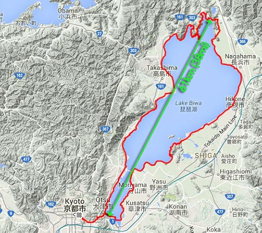
230km (143 miles) by bicycle
In the upper-rightish is the city of Nagahama, and that's about where
the first post ended, so that's where this one picks up. We're moving
around the lake in a counter-clockwise direction,
so we're still not half way.
For a while north of Nagahama there's no road along the shore, so we have to head inland a bit...
Panasonic LX100 at an effective 25mm — 1/1000 sec, f/5.6, ISO 200 —
map & image data — nearby photos
Amber Waves of Grain
11:44 AM (+6h 17m) - 107 km (66.6 miles)
taken while cycling at 21 kph (13 mph)
Panasonic LX100 at an effective 52mm — 1/1000 sec, f/5.6, ISO 200 —
map & image data — nearby photos
11:44 AM (+6h 17m) - 107 km (66.7 miles)
taken while cycling at 20 kph (13 mph)
Panasonic LX100 at an effective 24mm — 1/1600 sec, f/5.6, ISO 200 —
map & image data — nearby photos
11:44 AM (+6h 18m) - 107 km (66.7 miles)
taken while cycling at 20 kph (12 mph)
Panasonic LX100 at an effective 24mm — 1/800 sec, f/5.6, ISO 200 —
map & image data — nearby photos
Stardestroyer
11:48 AM (+6h 21m) - 109 km (67.6 miles)
taken while cycling at 22 kph (14 mph)
There wasn't much traffic this far north in the boonies, but at one
point a huge crane slowly passed us, making me feel like Princess Leia
consular vessel being slowly overtaken and consumed by Darth Vader's
Imperial Stardestroyer.
At about our half-way point, the main road goes through a long modern tunnel under some mountains. We'd rather go over the mountains, so we got onto the old original road and climbed the 50 vertical meters to
an old tunnel...
Panasonic LX100 at an effective 24mm — 1/60 sec, f/9, ISO 1000 —
map & image data — nearby photos
12:03 PM (+6h 36m) - 113 km (70.5 miles)
The name, written above the entrance (backwards) is ã賤ã¶å¶½é§éã,
using the old word (suido) that's since been replaced by the
Japanification of the English word “tunnel”. According to a plaque just
inside the entrance, it took a bit more than a year of digging to break through
the 1,260 shaku of length (382m / 418yd), and another two and a half years
to actually finish the tunnel in 1927 at a cost of 279,642 yen. I
don't know what the exchange rate was 88 years ago, but today that's about
$2,250.
Panasonic LX100 at an effective 30mm — 1/20 sec, f/13, ISO 1600 —
map & image data — nearby photos
Inside the tunnel it was pitch black except for a splash of light in the
center. Even in the day where you can easily see both openings, I wouldn't
want to do it without a light, for fear of monsters and creepy things. Ugh.
But a slow shutter can see in the dark, so after I got home I got to actually see what the inside
of the tunnel looked like:
Panasonic LX100 at an effective 24mm — 1/8 sec, f/1.7, ISO 1600 —
map & image data — nearby photos
Better Off Not Knowing
12:07 PM (+6h 40m) - 114 km (70.6 miles)
taken while cycling at 11 kph (7 mph)
Through to the other side, we were treated to a nice view of the lake....
Panasonic LX100 at an effective 24mm — 1/1250 sec, f/3.5, ISO 200 —
map & image data — nearby photos
60m Above Lake Biwa
12:09 PM (+6h 43m) - 114 km (70.8 miles)
This is pretty much at the exact spot where the green arrow in the map above touches at the top.
Panasonic LX100 at an effective 65mm — 1/200 sec, f/7.1, ISO 200 —
map & image data — nearby photos
Heading Back Down
12:16 PM (+6h 49m) - 115 km (71.1 miles)
The most direct path around the lake cuts off a peninsula of mountains that pierces the lake at its top,
but of course we wanted to hug the lake as much as possible, and climb the mountains as much as possible...
Panasonic LX100 at an effective 24mm — 1/400 sec, f/5.6, ISO 200 —
map & image data — nearby photos
Heading Into the Mountains
12:40 PM (+7h 14m) - 120 km (74.4 miles)
taken while cycling at 19 kph (12 mph)
Half an hour of hard climbing later...
Panasonic LX100 at an effective 28mm — 1/250 sec, f/10, ISO 200 —
map & image data — nearby photos
View Of Lake Biwa
from 280m above the surface
1:13 PM (+7h 46m) - 126 km (78.0 miles)
Panasonic LX100 at an effective 54mm — 1/100 sec, f/10, ISO 640 —
map & image data — nearby photos
Well-Earned Rest
1:15 PM (+7h 48m) - 126 km (78.0 miles)
Panasonic LX100 at an effective 50mm — 1/160 sec, f/6.3, ISO 200 —
map & image data — nearby photos
Another Pause Lower Down
240m above
1:36 PM (+8h 9m) - 130 km (80.6 miles)
Panasonic LX100 at an effective 32mm — 1/250 sec, f/6.3, ISO 200 —
map & image data — nearby photos
Plummeting Down
1:43 PM (+8h 17m) - 131 km (81.4 miles)
I went ahead and tried to set up for a panning “action” shot of Gorm
flying by, hoping I'd get everything blurry except him....
Panasonic LX100 at an effective 24mm — 1/60 sec, f/6.3, ISO 500 —
map & image data — nearby photos
1:47 PM (+8h 21m) - 134 km (83.0 miles)
He's sort of blurry too, but I'll claim partial success.
Once we alighted from the mountain, we had a pretty simple/flat 60-or-so
kilometers (~40mi) shot down along the shore to complete our loop.
Panasonic LX100 at an effective 35mm — 1/160 sec, f/6.3, ISO 200 —
map & image data — nearby photos
Annoying Japanese Habit
2:32 PM (+9h 6m) - 147 km (91.4 miles)
taken while cycling at 25 kph (15 mph)
Japanese people seem to love to smolder plant clippings, spreading smoke
everywhere. One farmer deciding to get rid of some cuttings can ruin a
whole town's futons and other fabrics hug out to dry. It boggles my mind,
but people just seem to think it's natural.
Two hours after descending the mountain, we catch our first sight of the
gate for the Shirohige Shrine, which we'd visited from the other (closer to
Kyoto) direction a month prior on my first ride that exceeded 100km. That
was the subject of “Pleasant 105km Bike Ride
Takashimaâs Shirohige Shrine”...
Panasonic LX100 at an effective 24mm — 1/400 sec, f/5.6, ISO 200 —
map & image data — nearby photos
First Sight of the Shrine Gate
(I think ... it'd be pretty tiny in this photo)
3:51 PM (+10h 24m) - 170 km (105.6 miles)
taken while cycling at 15 kph (9 mph)
20 minutes and 8km later, we're much closer...
Panasonic LX100 at an effective 25mm — 1/320 sec, f/6.3, ISO 200 —
map & image data — nearby photos
4:12 PM (+10h 45m) - 178 km (110.8 miles)
taken while cycling at 26 kph (16 mph)
Panasonic LX100 at an effective 28mm — 1/1000 sec, f/3.5, ISO 200 —
map & image data — nearby photos
Arrival
4:15 PM (+10h 48m) - 179 km (111.1 miles)
Shirahige Shrine (ç½é¬ç¥ç¤¾)
This was the first thing around the whole lake that was familiar, and at
least to me signaled the end of the challenge. Now we just had to get
home, but that was still a few hours off.
Panasonic LX100 at an effective 29mm — 1/125 sec, f/5.6, ISO 200 —
map & image data — nearby photos
Labor-Intensive Farming
5:11 PM (+11h 44m) - 198 km (123.0 miles)
taken while cycling at 29 kph (18 mph)
Finally at 6:00 in the evening we overlapped our morning path, completing our trip around the lake.
Panasonic LX100 at an effective 24mm — 1/1000 sec, f/2.2, ISO 200 —
map & image data — nearby photos
Objective Achieved
6:00 PM (+12h 33m) - 216 km (134.0 miles)
This was taken near the site of this photo from the
morning, almost 12 hours earlier.
Panasonic LX100 at an effective 24mm — 1/800 sec, f/2.2, ISO 200 —
map & image data — nearby photos
Now that we had completed the loop, we had to pop back over to Kyoto,
which first involved a 105m climb over a small mountain...
Panasonic LX100 at an effective 75mm — 1/125 sec, f/2.8, ISO 500 —
map & image data — nearby photos
Cresting the Pass
6:35 PM (+13h 9m) - 219 km (135.8 miles)
I'm happy with the amount of blur I get in the wheels and spokes at this shutter speed.
Kumiko was happy because she could do the hill (and indeed the entire
day) in her clip-in shoes. It gave her a lot of confidence with them.
Gorm was happy because he got to have a nice rest while waiting for us; he flew up that mountain.
Part of the descent down the other side is really steep, but the effect
is enhanced by being right next to a highway....
Panasonic LX100 at an effective 75mm — 1/160 sec, f/2.8, ISO 200 —
map & image data — nearby photos
Landing Approach
6:37 PM (+13h 10m) - 219 km (136.2 miles)
taken while cycling at 20 kph (12 mph)
After that, just before arriving home, there was one final 50m hill. The other side of the hill was the first
little climb of the day, and I was happy to find out when looking at the data later that I made a personal-best fast time on
both the climb leaving Kyoto that morning,
and the climb returning home that evening.
Both little climbs were ones that I had given my all on before, so it was all the more gratifying to make PRs on them
as bookmarks to my longest ride (in time and distance).
I returned home after almost 14 hours on the bike, and felt great. I guess distance doesn't tire me out, just vertical
climb, and this one had only about 1,500m (4,800 ft). The rides I've done since are shorter, but usually have
much more mountain climbing.


Jeffrey E.F. Friedl's Blog

- Jeffrey E.F. Friedl's profile
- 13 followers

