
Tim Havenith's Blog, page 16
May 1, 2020
Timeline Calne: 2 May 1945 - Calne's Welcome Home Fund
 Victory Celebrations at Bryans Close Road
(Calne Heritage Centre Collection)On 2 May 1945, the Mayor of Calne, Cllr Cyril Thomas, proposed the application for a Calne 'Welcome Home Fund'. This fund was registered with Wiltshire County Council under the War Charities Act, 1940, which was repealed in 1992.[1]
Rita Rickell writes in John Whiles Calne at War book that the origins of Calne's Welcome Home fund began in late 1944, when it looked as if the Second World War would finally come to an end.
Rita continues "Collecting boxes were mustered, labels for them were printed, and appeals went forth for folk to have fund raising events. According to hand written records in reference to this,a Mrs. Mlnnis made £7. 6s. 2d.by playing on"
All returing servicemen and women were given an initially wallet and a signed certificate. On 6 June 1945, the ex-prisoners of war were given a dinner at the Lansdowne Hotel.[2]
Thanks to Sharon Beaven for uploading a copy of the certificate to the Calne in Photographs Facebook group. The handsigned certificate to her father reads:
"To Frederick William BeavenThe inhabitants of Calne, Wiltshire, desire to extend a very warm welcome to you on your return to Civilian Life at the termination of your period of service in His Majesty's Forces.The also wish to record their sincere appreciation of the loyal service you have rednered to your King and Country and o extend to you this formal expression of their gratitude together with a small gift.On behalf of the Townspeople of Calne BoroughCyril H. ThomasMayor of Calne"
In total around 320 individuals were supported with the Calne Welcome Home Fund. Other local Welcome Homes funds included those for Lacock and Bowden Hill.
Around this time, Lance-Corporal Jack Stevens of the Somerset Light Infantry, from Calne, was awarded the Military Medal for gallant and distinguished service in North-West Europe[3].
Thankfully, on 8 May 1945, Germany surrended. After six years of war and the loss of millions of lives, the Allies had won the war and formally accepted Nazi Germany's unconditional surrender. This year, while in lockdown due to the Coronavirus, Wiltshire Council is encouraging us to celebrate the 75th anniversary of VE Day at home. Click here to see their advice and the VE Day pack.
References:
[1] 'War Charities Act, 1940' Wiltshire Times and Trowbridge Advertiser, Saturday 05 May 1945 [ONLINE] Available at: https://www.britishnewspaperarchive.c... [Accessed on 1 May 2020].
[2] Whiles, J., 1995. Calne at War. 1st ed. Chippenham: Antony Rowe.
[3] 'Awards for Service' Western Gazette, Friday 11 May 1945 [ONLINE] Available at: https://www.britishnewspaperarchive.c... [Accessed on 1 May 2020]
Note: For more information on military history, please visit Calne Heritage Centre.


Place Names of Calne: Aircraft
 Hurricane DriveIn recent years there have been some developments in Calne that have followed the theme of aircraft, both developments are accessed via Sandpit Road. The transport aircraft theme is accessed via Hercules Road, with the fighter themed streets (suggested in the Calne Town Development and Planning Committee of September 15, 2015) is accessed via Spitfire Road and include:
Street Name Full Name First Flight Produced Role Anson Avenue Avro Anson 24 March 1935 1930s-1952 Multirole aircraft, primarily a trainer Britannia Drive Royal Air Force (Bristol) Britannia C.1/C.2 16 August 1952 1952-1960 Long range Airliner Comet Crescent de Havilland Comet (Comet T2) 27 July 1949 1949–1964 Narrow-body jet airliner. RAF variant for crew training Dakota Drive Dakota II (Douglas DC-3) 17 December 1935 1936–1942, 1950 Military transport aircraft Hastings Drive Handley Page Hastings 7 May 1946 1947 – 1952 Transport aircraft Hercules Road Lockheed C-130 Hercules 23 August 1954 1954–present Military transport aircraft Hunter Close Hawker Hunter 20 July 1951 1954-2014 Fighter / Ground Attack / Reconnaissance aircraft Hurricane Drive Hawker Hurricane 6 November 1935 1937–1944 Fighter Lightning Road Lockheed P-38 Lightning 27 January 1939 1941-1945 Heavy Fighter Spitfire Road Supermarine Spitfire 5 March 1936 1938-1948 Fighter / Photo-reconnaissance aircraft Tornado Close Hawker Tornado 6 October 1939 Only 4 built Single seat Fighter York Road Avro York 5 July 1942 1943–1948 Transport
The Hercules Road development by Redrow Homes, was granted on appeal, but remained controversial. However the developer did contribute £450,000 to local education, improvements to Anchor Road community park, and to upgrade pedestrian and cycle facilities[1]. The development contains 2,3, and 4 bedroom homes of differing styles. The names for this development were decided in 2011, when Councillor A Hill suggested incorporating 'Hercules' due to the close bond between Calne and RAF Lyneham. Councillor Plenty, and mayor at the time, suggested 'Anson' due to the link between Calne and Yatesbury. These names and the others for this development were agreed at the same time[2].
The development off Spitfire Road was also initially refused in 2013, before being approved with an amended site plan in 2015[3].
Source https://en.wikipedia.org/wiki/Avro_Anson https://en.wikipedia.org/wiki/Bristol... https://en.wikipedia.org/wiki/De_Havi... https://en.wikipedia.org/wiki/Douglas... https://en.wikipedia.org/wiki/Handley... https://en.wikipedia.org/wiki/Lockhee... https://en.wikipedia.org/wiki/Hawker_... https://en.wikipedia.org/wiki/Hawker_... https://en.wikipedia.org/wiki/Lockhee... https://en.wikipedia.org/wiki/Superma... https://en.wikipedia.org/wiki/Hawker_... https://en.wikipedia.org/wiki/Avro_York
Resources:
[1] The Wiltshire Gazette and Herald. 2019. Disputed homes in Calne set to be built | The Wiltshire Gazette and Herald. [ONLINE] Available at: https://www.gazetteandherald.co.uk/news/8631042.disputed-homes-in-calne-set-to-be-built/. [Accessed 17 July 2019].
[2] CALNE TOWN COUNCIL TOWN DEVELOPMENT AND PLANNING COMMITTEE, 29 March 2011.
[3] N/10/03389/FUL
April 29, 2020
Timeline Calne: 1340/1341, Calne's Great Fire (with notes on subsequent fires)
 Calne Fire Station, Station Road.Depending on the source, we can see that 1340 or 1341 saw a serious fire within Calne. One that destroyed the greater part of the best houses of Calne, which were likely to have been wooden structures.[1]
Marsh tells us that the Church Registers detail the frequent occurrence of fires within Calne after this event.
Some of the major fires that have happened in Calne have occurred in and around the mills. Such as the fire next to Kew Lane mill (now Anchor Road). A fire in 1815, saw a warehouse or factory likely destroyed by fire as the Salisbury Journal reported "the engines were immediately procured, but from want of practice they did little service".
In 1884, it was the mill that experienced the destruction of fire. By this time, the road was called Cow Lane, and the mill was occupied by Mr. Robertson. The fire was discovered around one o'clock on 29 February 1884. Luckily Mr. Robertson, who occupied the house next to the mill, escaped without harm, however the mill and house were completely gutted, with only a cottage attached to the south west of the mill surviving. The mill was owned by Lord Lansdowne, who may have repaired the mill.[2] However, by 1899, the buildings had been demolished. The likely home for the mill was on the island near Brewers Lane.
Horsebrook Mill was another that faced a series of fires, and in 1962, Moss' mill was destroyed by fires. In 1967, Castle House was partially destroyed by fire.
We are fortunate to have a fantastic on-call crew that operate from Calne Fire Station on Station Road.
Let's hope Calne never has to experience such devastation again.
References:
[1] Marsh, A., 1903. A HISTORY OF THE BOROUGH AND TOWN OF CALNE. 1st ed. London: HAZELL, WATSON AND VINEY, LTD.
[2] "Fire at Calne" Devizes and Wiltshire Gazette, Thursday 06 March 1884 [ONLINE] Available at https://www.britishnewspaperarchive.c... [Accessed on 19 April 2020]
March 31, 2020
Place Names of Calne: Luckett Way
 Luckett Way
 Luckett's portrait hangs with his follow
mayors in the Calne Town Hall.Luckett Way, built in the 1960s, honours Henry Augustus Luckett, the Mayor of Calne for 1875[1].
He is listed as a draper on Calne's Church Street, in the 1855 and 1875 Post Office Directory. He's also listed as a draper in the 1867 and 1889 editions of Kelly's Directory of Wiltshire.
In his will of 1897, Luckett gave an income of £100 for the benefit of the women living in the almshouse at Christmas, in 1904 £2 4s was spent on coal for them[2].
References:
[1] Marsh, A., 1903. A HISTORY OF THE BOROUGH AND TOWN OF CALNE. 1st ed. London: HAZELL, WATSON AND VINEY, LTD.
[2] Calne: Charities for the poor | British History Online. 2019. Calne: Charities for the poor | British History Online. [ONLINE] Available at: https://www.british-history.ac.uk/vch/wilts/vol17/pp114-116#anchorn2 . [Accessed 04 February 2019].
March 29, 2020
Timeline Calne: 1920 - C. &. T. Harris' St. Dunstan factory built
 St. Dunstan Factory and Bank House, C. & T. Harris. Photo Credit: Don Lovelock Collection, Calne Heritage CentreThe massive factory, originally known as St. Dunstan's, had four storeys plus a basement level. The factory was of brick-clad steel construction, but the design of Hall Williams and Company.
The basement was used as cellars and chill rooms, with the ground floor for pie making. The first floor was used for offices (with Bank House, also offices and a laboratory), with the second floor was used for the manufacture of sausages. The third floor saw the canning operations, with the fourth floor having a kitchen. The building had many lifts, with one managing a load of up to 3.5 Tons.
 Rooftop view.
 Photo Credit: Don Lovelock Collection, Calne Heritage CentreThis factory was built on the site of Grade II listed, St. Dunstan's House, which was taken down and then rebuilt at Lickhill Road. This site, which is now home to Carnegie Mews and the Heritage Quarter car park, is the reputed site of the infamous witan. This witan, held in 978 on the first floor of the building used for the meeting, was discussing the matters of Benidictine Rule of the church, including the celibacy of priests, which St. Dunstan was in favour of. At some point, the floor collapsed, with Dunstan alone managing to escape injury by supporting himself on a beam[2].
 Demolition of the factory.
 Photo Credit: Don Lovelock Collection, Calne Heritage CentreBetween 1984-85, this factory was demolished, as the people of Calne said goodbye to the bacon industry that had been the main employer for so many years.
References:
[1] Bromham, J., 1985. C and T Harris (Calne) Limited - a Brief History -. 1st ed. Self publication
[2] Calne, Past and Present: Timeline Calne: 978, Archbishop Dunstan and the Calne witan. [ONLINE] Available at: https://calnepastandpresent.blogspot.com/2019/02/timeline-calne-978-archbishop-dunstan.html. [Accessed 28 March 2020].
Notes:
To see more of the Don Lovelock Collection, visit Calne Heritage Centre. For more information see: calneheritage.co.uk
February 29, 2020
Place Names of Calne: Anchor Road
[image error] Ancher RoadAnchor Road is named, most likely, after the inn that was open for business between 1780 and 1842. The Anchor Inn was located close to the Recreation Ground's old caretaker’s cottage, 3 Anchor Road, close to the tennis courts.
Marsh[1] states that:
"Close to the vicarage is the piece of land once called the “Anchor”, where until it was suppressed in the middle of the last century, annually on Easter Monday was held the saturnalia known as the “Anchor Revel”, and where, apparently, in 1610 Thomas Gryffin, a shoemaker of the town, “being destitute of a house to dwell in, and having a wife and four poor children”, was allowed by the Quarter Sessions to build a house without regard being paid to the Act of 1589, which required four acres of land to be attached to each. Some years ago Mr. Thomas Harris purchased the land, and, after laying it out as a public recreation ground, gave it to the town."
I have not been able to find any further information about the "Anchor Revel" so far.
 Anchor on The Thatched Cottage, Anchor Road.Moving forward in time to the 1840s, the plot of land across the road from the Anchor Inn, was known as 'Anchor Garden' (where the pavilion is now), owned by the Marquis of Lansdowne and occupied by Honor Little. Further investigation has revealed that the Marquis of Lansdowne held the land as lessee under the Ecclesiastical Commissioners, therefore this was Church of England land[2]. The land that the Anchor resided on (plot 479 for tithe purposes) was owned and occupied by Richard Greenup. It is entirely possible that the pub was named for the Anchor Revel that took place during those times.
This particular street has been known by many names over the years, including Kew Lane (which went on to refer to the southern end of the street for a time[3][4], and Eastmead Street[5].During the time the inn was open the street was called Cow Lane (possibly a corruption of Kew)[1].
References:
[1] Marsh, A., 1903. A HISTORY OF THE BOROUGH AND TOWN OF CALNE. 1st ed. London: HAZELL, WATSON AND VINEY, LTD.
[2] 'Land at The Anchor' Devizes and Wiltshire Gazette, Thursday 18 April 1889 [ONLINE] Available at: https://www.britishnewspaperarchive.c... [Accessed on 1 October 2019]
[3] Chandler, J., 1996. PRINTED MAPS OF WILTSHIRE 1787-1844 (Volume 52). 1st ed. Trowbridge: Wiltshire Record Society. (Robertson map 1792)
[4] Wiltshire XXVII.5 map, published 1886.
[5] Wiltshire XXVII.NW map, published 1925
February 13, 2020
Timeline Calne: 997 Witan at Calne
 Ethelred the Unready.After the disatrous Witan of 978, which led to many deaths, the witan of 997, during the reign of Aethelred the Unready (see below) is said to have occured in the hall of the palace at Calne[1]. The hall, of course, being on the ground floor.
After a few days, the witan transferred to Wantage, with the result being a code of laws being drawn up, along with the standard confirmation of the King's grants of lands and privileges.
These laws deal with the administration of justice and the preservation of leace. The whole witan including an entire group of bishops, abbots leaders and noblemen and noblemen[2].
The relevant section of the passage:
"collecta haud minima sapientium multitudine, in aula villae regiae quae nuncupative a poppulis Et Calnea vocitatur"
General translation:
"the multitude of the wise is by no means the least be a solemn assembly, in the royal court of the people called the Calnea"
While nothing dreadful happened at Calne, 997 did see the return of the Danes, starting that year in Cornwall, Devon, western Somerset, and south Wales. Following years saw attacks on Hampshire, Sussex, and Kent, before leaving for Normanby, the English, this time, successful in denying the Danes.
However, the Danes returned and in 1002, the English bought a truce for the sum of £24,000. Aethelred continued to make frequent payments to the Danes and while payments such as these had been made for at least the previous Century, Aethelred's frequent payments are seen as illistrative of incompetant governance. At times, it must have felt that these payments were the only way to keep his people and their way of lives safe. By 1016, Cnut became king of the whole of England, with Ethelred's being buried in Old St. Paul's Cathedral in London, his tomb and monument destroyed along with the cathedral during 1666's Great Fire of London[3].
Interestingly, the above passage states that the Witan was held as the "Royal court", which may refer to the castle at Calne. An archeological dig in 2010 found evidence of a substantial fortified tower, which may have been part of a larger structure or attached to a manor house near the site of present day Castle House. Findings included a well lined with cut and shaped stone within one of the walls, to a depth of at least 7.3 metres. This hints that the tower, which was an estimated 13 metres tall, was defensive, to ensure water supply during a siege. The building, most likely here in the Middle Ages, was a crenelated semi-fortified tower house, which was a type of castle built for defense and habitation up until the 17th century.
References:
[1] Kemble, J., 1876. texts The Saxons in England : A history of the English commonwealth till the period of the Norman conquest. 1st ed. London: B. Quaritch.
[2] Freeman, E A., The History of the Norman Conquest of England: Its Causes and Its Results. !st ed.
[3] Wikipedia. 2020. Æthelred the Unready - Wikipedia. [ONLINE] Available at: https://en.wikipedia.org/wiki/%C3thelred_the_Unready. [Accessed 12 January 2020].
January 31, 2020
Place Names of Calne: Bishop Road
 Photo Credit: Lucy Havenith
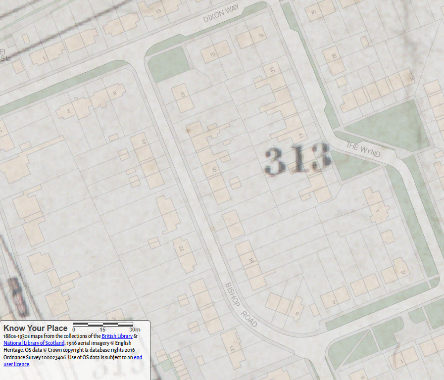 Know your place. 2017 Basemap with 1840s
tithe map overlayed showing the current
Bishop Road and the plot number
from the 1840s.
The 1840s Tithe map shows Bishop Road as plot 313. This was owned and occupied by John Dommett Bishop and was called Bryant's Close & Theobald's Piece. It was listed as arable land.
The land eventually became part of C. & T. Harris owned Newcroft Farm, which Calne Town Council acquired for development in the 1950s and 1960s.
Not only was John Dommett Bishop a GP, living at a '1 Marsh Cottage', Calne in the 1861 census[1], he was also the Calne Town mayor in 1863, 1873, 1883, 1888 and 1893[2].
Bishop Road, built in the 1950s on what used to be Henley Road. Interestingly there was a Bishops Road further down Bryans Close Road, which is now Fynamore Place. Bishop Road is one of many streets in Calne named after previous mayors, and they will be discussed in subsequent posts.

The terraces of Bishop Road use a great mix of pebble dash and render to create character in the form of different shapes.
References:
[1] FreeCEN - UK Census Records (England, Scotland, Wales). 2019. FreeCEN - UK Census Records (England, Scotland, Wales). [ONLINE] Available at: https://www.freecen.org.uk/search_records/59069478e9379091b10bda13?search_id=5c4d4312f493fd6c6ea49b95 . [Accessed 27 January 2019].
[2] Marsh, A., 1903. A HISTORY OF THE BOROUGH AND TOWN OF CALNE. 1st ed. London: HAZELL, WATSON AND VINEY, LTD.
January 19, 2020
Timeline Calne: 20 January 2000, Calne Bypass
 Calne's northern bypass nearing completion.In November 1970, Towning Hill and Partners published the Calne Town Study Report. Among other suggestions about how Calne could grow and develop, it included proposed roads. One of these suggested roads was a bypass that would have provided a way around Calne, without having to travel within it.
Fast forward 17 years and we find the idea of a bypass, or relief road, appearing in the press. Wiltshire County Council had been exploring an extension to The Pippin, one of four options at the time, which would have created an internal relief road. In August 1987, an article appeared that reported that Gordon Mitchell, the director of the Calne Project was asking the County Council to withdraw support for that plan in favour of a northern relief road.
A protest meeting at John Bentley School in December 1988 was attended by 300 people. This made it clear that local people did not want to discuss the four inner relief road options, there had been too much demolition of historic buildings in Calne already. They put forward the idea of a Northern Distributor route. It was now clear that there was a total opposition for any internal relief road[1].
In 1989, a decision for the Calne relief road was made at County Hall in Trowbridge, with 70 campaigners present. All four inner relief road ideas were rejected. At that time, there was no official mention of an external relief road. All money allocated to the inner relief road scheme was diverted to other projects throughout the county. The County Council was reported as saying that they couldn't afford a new relief road anyway.
Previously, in 1987 a confidential meeting between Heron Homes and Jonathan Taylor of the Calne Project took place. Heron Homes wanted to build 96 homes near Chilvester Farm, which aligned well with the Northern Distributor route idea championed by The Calne Project. One letter from Heron Homes to The Calne Project closes by saying "As I see our respective projects going very much hand in hand."[2]. It seemed clear at that point that both groups had the same idea about this development initiating the start of the bypass route.
This development proceeded in the early 1990s, and created Greenacres Way, the beginning of the Northern Distributor route.
Yet more time passed and it wasn't until May 1999 that there were boots on the ground, or rather heavy machinery, scraping out the route of the relief road. By June 1999 there were aready areas tarmacked, but it wouldn't be until January 2000 that the job was complete.
 (left to right are likely): Calne Mayor, Deborah Smith, Cllr Fleur de Rhe-Philips (Wiltshire County Council), and Mrs. L. M. Barber (Chair of the North Wiltshire District Council), and Duncan Davidson (Persimmon Homes chairman).20 January 2000, around 12:45, saw the opening of the bypass, with coachloads of visitors brought in by Hatts Coaches. The ribbon was cut by four officials, not all the names are known for certain, but are likely to be (left to right): Calne Mayor, Deborah Smith, Cllr Fleur de Rhe-Philips (Wiltshire County Council), and Mrs. L. M. Barber (Chair of the North Wiltshire District Council) Duncan Davidson (Persimmon Homes chairman).
North Wiltshire District Council loaned Persimmon Homes £3.5 million to build the relief road. To bring forward the building of the road Calne Town Council contributed £250,000, while Persimmon Homes and North Wiltshire District Council settled the remaining £950,000.
After 30 years, Calne finally had the external relief road suggested by Towning Hill and Partners.
However, that's not quite the end of this tale. The Calne Twinning Association were told that they could decide the name of the road, choosing Caln Pennsylvania Drive in celebration of our twin town Caln, Pennsylvania. However, after a 500-signature petition in favour of 'Beversbrook Road' was handed in to the Calne Area Committee, of the then North Wiltshire District Council, the name was changed[3]. At its northern end, Beversbrook Road runs alongside the medieval settlement of Beversbrook, which is a Scheduled Monument.

Since opening much housing has been developed by the Calne Consortium headed by Persimmon Homes, who also provided Fynamore Community Primary School. This development is called Lansdowne Park. It has also provided much traffic relief within Calne itself, however the fabled eastern bypass is becoming more pressing as time goes on., but is not part of the 2016-2026 Calne Community Neighbourhood Plan.
References:
[1] WSHC 3271/32
[2] WSHC 3271/27
[3] The Wiltshire Gazette and Herald. 2019. Rethink over bypass name | The Wiltshire Gazette and Herald. [ONLINE] Available at: . [Accessed 17 December 2019].


![[image error]](https://1.bp.blogspot.com/-zg9ARMMbEq4/XQ1GIx_LSqI/AAAAAAAAY6A/r3JM7eclXW4ByhrN6A--e-yckeRI8Ka0gCLcBGAs/s1600/DSC04434.jpg)