
Trail of the Week: Linville Gorge Wilderness Loop, North Carolina
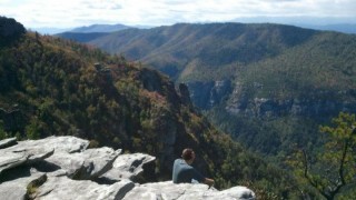
Photo: Max Willner
Our Trail of the Week feature is made possible through a partnership with Trail Run Project, a crowd-sourced collaboration by and for the running community. Thanks to Max Willner for mapping and describing this route.
The Linville Gorge Wilderness, in the mountains of western North Carolina, is part of the Pisgah National Forest. The gorge is formed by the Jonas Ridge on the east and Linville Mountain on the west and is bisected by the Linville River which drops 2,000 feet into the valleys below. The terrain is steep and rugged with numerous rock formations. It is covered by dense hardwood/pine forest and a wide variety of smaller trees and other plants.
This loop is 22 miles long, and is considered very strenuous. Due to the rugged backcountry conditions of the Linville Wilderness, it’s a good idea to check in with the rangers and inform them of your travel plans.
Trails are signed at trailheads but are not signed or blazed once inside the wilderness.
The Data
Miles: 22.3
Runnable: 81 percent
Average Grade: 9 percent
Max Grade: 65 percent
Total Ascent: 5,262 feet
Total Descent: -5,264 feet
Highest Elevation: 3,922 feet
For a closer look, check out the interactive map, data, photos and virtual run simulator courtesy of Trail Run Project:
The post Trail of the Week: Linville Gorge Wilderness Loop, North Carolina appeared first on Competitor.com.


Ryan Hall's Blog

- Ryan Hall's profile
- 21 followers

