
Launch of the LDCM: Continuing 40 years of Landsat Data
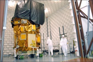
In 1972, NASA launched its first Landsat satellite into orbit. This February, it will launch its eighth.
The new satellite is part of the Landsat Data Continuity Mission, a collaboration between NASA and USGS that will continue adding to 40 years worth of data about the Earth’s surface.
In what is now the longest-running project of collecting satellite imagery of Earth, Landsat data offer an important resource for a variety of endeavors: from cartography to natural disaster management; urban planning to the monitoring of natural resource usage. Moreover, the unprecedented continuity of data offers invaluable insight into the way that Earth has been changing over the past 40 years.
Landsat 8 will be the most advanced of them yet, promising not just the continuation of data collection, but more precise data that will enrich ongoing geological, ecological, and geographical research.


Stewart Brand's Blog

- Stewart Brand's profile
- 291 followers

