Backpacking the Red Run/Mosquito Creek Loop-Quehanna Wild Area
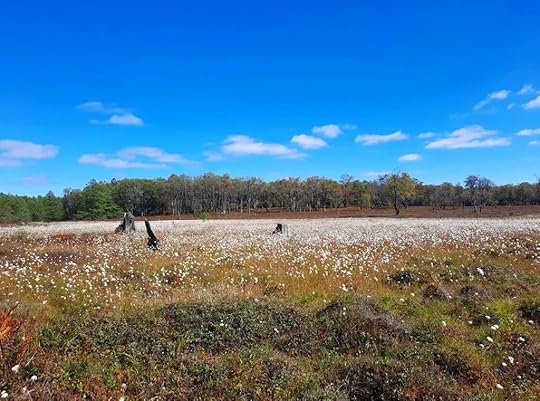
 Cottongrass superbloom in late September. Quehanna Wild Area.
Length: About 17 miles.
Parking: Large parking area at Beaver Run Dam, 41.261312, -78.257948.
Blazes: Quehanna Trail is orange, other trails are yellow. South of Quehanna Highway, Red Run Trail might be red (can’t remember!)
Level of Challenge: Easy to moderate
Highlights: Isolation, cascades, beautiful streams, diverse forests, large rocks, views, vast meadows, beaver dams, chance to see elk, good camping.
Issues: Stinging nettle in a few places, particularly Porcupine Draft, wet and muddy areas, creek crossings in high water. Need to navigate a variety of trails. Many trail junctures have signs.
Description: I love the Quehanna Wild Area. It is one of my favorite places to backpack and hike with its views, streams, meadows and isolation. Its web of trails offers so many route options and it provides great scenery without punishing terrain. Go there, you won’t regret it.
This is a great loop for an overnight backpack or a long dayhike for those looking for a challenge. This description begins from the Beaver Run Dam parking area and is clockwise. Follow the yellow trail on the east end of the parking area, pass a meadow and cross the Quehanna Highway. Reach a great vista and descend; watch for a left hand turn at the forest clearing, it is easy to go straight. Descend to Paige Run, a gorgeous creek with cascades, giant boulders, hemlocks and rhododendrons. Cross the creek and make a short climb. Turn left onto the Teaberry Connector with meadows and then turn right onto the East Cross Connector (ECC) as it meanders through laurel and hardwoods. Reach a forest road and follow it to the right.
Turn right onto the Quehanna Trail (QT) as it descends into the steep gorge of Porcupine Draft, which is notorious for nettle in summer. Yet, the gorge is scenic with some large boulders and nice cascades. Turn right onto Red Run Road and follow it. The QT crosses Red Run over a bridge. The scenery is beautiful. Hike up near the creek with hemlocks and rhododendron. You will also see some campsites. The trail veers up Sanders Draft, a highlight with its large cascades and pools. It is beautiful. Enjoy this section.
At the top is a nice campsite. Turn right onto the yellow Sanders Trail. This section is blazed sufficiently, but you must pay attention to turns as there are other interconnecting trails. I enjoyed the forest isolation of this section and the beautiful hemlocks. There are wet areas. Cross a powerline and enjoy more scenic woods dotted with hemlocks. Reach a meadow and a pipeline swath, which can serve as a campsite. The stars are amazing.
Continue as the trail threads along meadows and streams. Enter a pine forest and pass another campsite. Reach Lincoln Road and a small trailhead. Turn right and then left onto the connector trail to the Quehanna Highway. Now follow the Red Run Trail as it explores a large hardwood forest with ferns everywhere, an amazing sight in autumn. Turn right onto the Ralph Seeley Trail. I loved this trail with its assortment of meadows, streams and hemlocks. Turn left onto the ECC and hike along Meeker Run with a great campsite under hemlocks. There are some cascades just off the trail.
Turn right, leave the ECC, and climb to beautiful Crawford Vista as it overlooks the Mosquito Creek gorge. Make a sharp left onto the Mosquito Creek Trail, which can be easy miss. Descend to Mosquito Creek with a campsite and hike along the creek, following the Bridge Trail. There are rapids and giant boulders across the creek. Climb and cross the vast meadows. If hiking in September, look off to your right for the superbloom of cottongrass, there are plains of white.
Return to the ECC and turn left, crossing more meadows and views while hiking above Beaver Run. This area resembles Dolly Sods in West Virginia. Cross Beaver Run over a bridge (a beaver dam downstream has started to flood the bridge, so expect wet feet). Follow the ECC across meadows and woodlands. Reach the dam of the Beaver Dam impoundment and turn right across the dam, leaving the ECC. Enjoy the views over the water. Pick up a road and follow it back to the parking area.
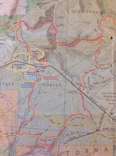
 Route is the pink/red line. Description is clockwise from the Beaver Run Dam parking area. Black dots are campsites. Blue dots are cascades.
More photos:
View this post on InstagramA post shared by Jeff Mitchell-Outdoors Author (@hiking_mitch)
View this post on InstagramA post shared by Jeff Mitchell-Outdoors Author (@hiking_mitch)
View this post on InstagramA post shared by Jeff Mitchell-Outdoors Author (@hiking_mitch)
View this post on InstagramA post shared by Jeff Mitchell-Outdoors Author (@hiking_mitch)
View this post on InstagramA post shared by Jeff Mitchell-Outdoors Author (@hiking_mitch)
View this post on InstagramA post shared by Jeff Mitchell-Outdoors Author (@hiking_mitch)
View this post on InstagramA post shared by Jeff Mitchell-Outdoors Author (@hiking_mitch)
View this post on InstagramA post shared by Jeff Mitchell-Outdoors Author (@hiking_mitch)
View this post on InstagramA post shared by Jeff Mitchell-Outdoors Author (@hiking_mitch)
View this post on InstagramA post shared by Jeff Mitchell-Outdoors Author (@hiking_mitch)
Jeff Mitchell's Blog
- Jeff Mitchell's profile
- 3 followers


