
How to navigate || Part 5: Skills + knowledge checklist
Within a few days of starting my Appalachian Trail thru-hike in 2002, I learned dead-reckon navigation using my watch and the datasheet. With surprising accuracy, I could now monitor my hiking pace, pinpoint my location between known landmarks, and predict my arrival time at upcoming points of interest like water sources and shelters.
On an as-needed basis during later hikes, I learned additional navigation skills. For example:
On the Sierra High Route, my first off-trail experience, I learned how to really read a map;On the Hayduke Trail, I learned to use my compass to track my location in meandering canyon bottoms;On the Colorado Trail, I used my altimeter to rule out false summits on big climbs; and,While skiing along Alaska’s Arctic Coast, I used GPS to calculate the distance to landmarks ahead, like the shoreline.
It’s worth noting that my navigation skills took a leap forward when I began guiding. “Those that know, do. Those that understand, teach.”
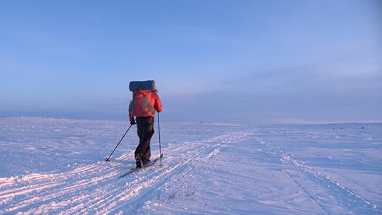 Alaska’s Arctic Coast gave me reason to learn to use GPS. In this featureless and frigid landscape, a GPS was faster and more reliable than map-reading and dead-reckoning.
So far in this tutorial on backcountry navigation, I’ve written about:
Part 1: IntroductionPart 2: Maps and resourcesPart 3: EquipmentPart 4: Navigator’s mindsetPart 5: Skill & knowledge checklist
To finish it off, I will offer a checklist of essential:
Definitions,Concepts, andSkills
It’s beyond the scope of this post to teach readers this knowledge and these skills, however. On a 5- or 7-day guided trip, we normally have enough opportunities to cover all of it, and it’s unreasonable to think it can be covered in 1,500 words.
Instead, it’s all on you: find videos, books, and classes that fill in the gaps of your knowledge and skill set, and most importantly practice. To get you started, I have linked and embedded a few of my own tutorials.
Maps
A topographic map (more info) is perhaps the most essential navigational aid. In many parts of the West, it can be used exclusively to get around.
Scale
Explain the map scale.How does the scale correspond to real distances. For example, one inch on a 1:24,000-scale map equals what distance in the field? What about 1:62,500 or 1:100,000?Measure the straight-line distance between two points.Measure the distance of a meandering trail.Measure distance using your finger, the scale-specific ruler on your compass, and your compass lanyard.Become familiar with the size of features on the map relative to their size in the field.
Pro challenge: Learn the relationship between different map scales and different contour lines (e.g. a 24,000 map with 40-foot contours, or a 63,360 map with 100-foot contours) so that the topographic size of new landscapes does not surprise you.
Contour lines
What is a contour line?What is the contour interval of your map?What is the difference between index contours and intermediate contours?Identify areas on the map that are: flat, moderate and steep.Identify high points, like summits, knobs, and hilltops.Identify low points, like lakes, creek bottoms, and dry gullies.Develop a general understanding of the landscape on your map, notably its major ridgelines and drainages, and its corridor trails. Calculate the vertical change between two points.Associate terrain on your map with the terrain in the field.
Pro challenge: Predict whether a pass or summit will “go” based on the steepness of the slopes below it. Also, account for where snow is likely to linger.
Shading
In areas shaded in green, what will you generally find?In areas without shading, what will you generally find?Explain the variants of blue: continuous line, intermittent line, solid blue, and blue stripes.On your particular map, what are the types of things that you will find in areas with green shading or no shading? For example: tree types, tundra, tussocks, bogs, slabs, talus, and sand.
Pro challenge: Predict the exact ground cover or vegetation you are likely to encounter at specific elevations, on specific slope aspects, and adjacent to specific types of land forms. Examples:
A moderate slope at 8,500 feet on the east side of Rocky Mountain National Park is shaded green. What type(s) of tree(s) will you likely find there?A streak of white cuts through a forest on a steep slope below a 6,000-foot peak in the Cascades. Why, and what will you find there?The base of a 1000-foot sheer wall in the High Sierra is unshaded. What will you probably find there?
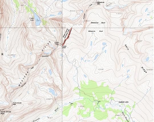 When you look at this 1:24,000 map, can you: Identify high and low points, measure the distance and vertical change between two points, and anticipate the ground cover (e.g. tundra, slabs, talus, dirt)?
Cartography
In a mapping platform like CalTopo:
Import a GPX file.Annotate the map with important route notes.Create a track, and measure its distance and vertical change.Enter this distance and vertical data into a spreadsheet to create a datasheet.Print a topographic map (or map set) at your preferred scale and on your paper size.
Watch
A basic, altimeter, or GPS watch (more info) is an essential tool for dead-reckoning, which is one of the most useful skills for on-trail hikers.
The fundamental formula is: DISTANCE = RATE * TIME
Calculate your average RATE using DISTANCE and TIME.Convert your RATE (e.g. MPH) into pace (e.g. 20 minutes per mile).By how much will your RATE be affected by variables like vertical change, altitude, and trail quality?Calculate the DISTANCE you have hiked using RATE and TIME.Calculate your ETA at an upcoming landmark by using your RATE and the DISTANCE.
Compass
Particularly in areas with limited visibility and subtle terrain, a backpacking compass (more info) is a lifeline, even in modern GPS-dominated times. In more favorable conditions, it can still be used to support your navigational story.
Explain declination.What is the declination of your current location?If you have an adjustable compass, adjust it for declination.Orient the map.Find a bearing in the field, and transpose it to the map.Find a bearing on the map, and transpose it to the field.Find a bearing in the field and transpose a bearing to the field, using both an adjustable compass or non-adjustable compass.Follow a bearing.
You might notice that triangulation does not make my list. To me, this seems like a useful technique only after I get lost, and frankly I find it easier to simply stay found. Plus, if you do get lost, you can locate yourself more quickly and more precisely with a GPS device.
Altimeter
An altimeter watch (more info) uses barometric pressure to calculate its elevation, and is an extremely useful tool in mountainous environments.
Calibrate your altimeter using a known reference point.Follow a contour, i.e. cover horizontal distance without losing or gaining elevation.Rule out false summits.Climb or descend to a specific elevation where an additional action must be taken, like leaving the trail.Pinpoint your location by cross-referencing your altitude against a nearby topographic feature, like a lake outlet or a creek confluence.
Pro challenge: Before a steep climb, predict your arrival time at the top using your normal rate of vertical speed (e.g. vertical feet per minute).
 Contouring at around 10,800 feet on the Sierra High Route between Evolution Basin and Snow Tongue Pass
GPS
When your map, watch, compass, and altimeter are not making sense, resort to the ace up your sleeve: a GPS device (more info).
Download maps for off-line use, so that your smartphone can function as a GPS (with maps) even without cell service.Set your GPS devices and map grids to a consistent datum.Upload tracks and waypoints to your device.Extend the battery life of your device by switching it to airplane and battery-saving mode (and, more importantly, by instead using non-consumptive tools like your paper map and compass).Pinpoint your location.Create a waypoint.Create a route to a waypoint.Create waypoints and record your tracks, and export it later as a GPX file that can be imported to a platform like CalTopo.
Pro challenge: For how long can you run your GPS device before it must be recharged?
Off-trail navigation
Find the overall path of least resistance from Point A to Point B by accounting for the individual effects of:
Horizontal distance,Vertical change,Vegetation,Ground cover,Game trails,Time sinks like canyons, cliffs and ledges, brush thickets, blowdowns, loose moraine slopes, and deep water.
The best line rarely “cuts against the grain” of the landscape. Instead, it goes directly with or against the fall lines, and works seams of weakness.
Simplify your route-finding by utilizing natural features:
Follow handrails, like a creek, ridgeline, or shoreline; and,Hike until running into a backstop, like a creek, trail, or ridge top.
Find relatively safe lines through areas with natural hazards like:
Creek fords,Snowfields,Avalanche zones.
Leave a comment
Do you have questions about the listed skills?What skills should be added to this list?How have you developed these skills? What resources what you recommend most?
The post How to navigate || Part 5: Skills + knowledge checklist appeared first on Andrew Skurka.


