
Paul E. Fallon's Blog, page 63
September 23, 2015
Trip Log – Day 140 – Ashland, OR to Mount Shasta, CA
 September 22, 2015 – Sun, 85 degrees
Miles Today: 84
Miles to Date: 7,305
States to Date: 24
Today was a strenuous reminder of cycling’s rigor. It’s been some time since I rode over eighty miles or a mile of vertical climb. Today I had both.
 The Rogue River Valley over Ashland was shrouded in clouds when I began my long slog up and out. Like most, the valley runs north/south. But the Siskiyou Mountains, the only range in the West that runs East/West, cut the valley short, leaving Ashland in a bowl that empties to the north. After fifteen miles, and more than two hours of pedaling, I joined I-5 within a mile of that Interstate’s highest point. It’s an unpleasant place for a cyclist. The fog was dense, the shoulder as wide as the road, but many trucks pulled over to check their brakes before the descent.
Within a minute, literally, of rolling downhill, the fog lifted and the skies were crystal blue. Welcome back to California! I had to remain on I-5 for twelve miles, through the ritual produce checkpoint, until I reached the Klamath River Parkway.


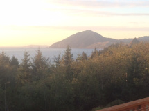
The ride between the Klamath River and Yreka is spectacular. The road was built in the 1930’s, with graceful, narrow bridges high above the Shasta River. About halfway through I caught my first glimpse of Mount Shasta, framed between two hills with its namesake river running beneath me. It looked so tiny in the camera frame. Little did I know that it was over fifty miles away and would just grow bigger as the day progressed.

I stopped for lunch in Yreka, the epcienter of the independent State of Jefferson movement. Signs for ‘No Monument’ and ‘No Dam Removal’ were everywhere. It’s not clear why back to the earther’s don’t want a Klamath River National Monument designation or local dams removed so they can run free again. Then again, they don’t want to be part of California; they don’t want to be part of the United States. They are just much better at ‘No’ than anything ‘Yes’. Does that attitude have anything to do with why I went to three eateries for lunch before I found one that took my order? Kitchen folks in the first two simply didn’t bother to come out as I stood at the counter.

No matter, the third place had tasty burritos. I left Yreka and made my way along tranquil country roads just beyond earshot of I-5. Mount Shasta evolved from an occasional presence to a fixed point. Problem was, I never seemed to move in relation to the mountain. The winds picked up, the grade tilted, and I worked hard, but my perspective on the mountain never changed.

Of course it did, just not as quickly or as easily as I might have liked. That’s when cycling is like yoga. So I took a break, breathed deep, fixed my attitude, and pedaled on. Finally, after moving toward the mountain for hours, I began to move around it, to approach the City of Mount Shasta.

It was almost seven when I arrived at my warmshowers host. The pain of the day scrubbed away with the grime on my shins. By the time I sat to dinner, it seemed fortuitous that the mountain chose to be such a constant presence.


September 22, 2015
Trip Log – Day 139 – Ashland, OR
 September 21, 2015 – Sun, 80 degrees
Miles Today: 38
Miles to Date: 7,221
States to Date: 24
Another perfect day in Ashland, which I spent visiting Ashlanders. My host Steve set up appointments with the Director of Scienceworks, a hands on museum in town, followed by coffee with John Javna, freethinker and author of Fifty Simple Things You Can do to Save the Earth. Then I cycled up to Medford to meet with Steve and his partners at Lime Rock, a design and manufacturing company specializing in motion tracking devices. Finally, I met with Neil Smith of Airscape Fans. By the time I finished talking with these fascinating guys and pedaled back to Ashland, it was dark.


Cycling-wise, I enjoyed riding the Ashland/Medford trail again. First, because its a beautiful trail. Second, because I don’t often get to retrace my steps and experience something familiar from a new perspective. Third, I had another serendipitous meeting along the way.

 A few miles outside of Ashland someone has installed a Bike Journal mailbox. On Sunday, I wrote in it on my way into town. Today as I rounded the bend near the mailbox, a man was reading the journal. His wife pointed to the book and called out, “Are you that guy?” Of course I had to stop and chat with Robert, Denise, and their dog jazz.
 Steve and Dorothy treated me to a delicious dinner at The Loft in downtown Ashland. They are in the middle of the ‘Whole 30’ diet – no sugar, not gluten, no bread, and a few other ‘no’s’ I cannot recall – while I just eat large quantities of anything. Explaining our order to the wait staff was a 21st century version of When Harry Met Sally. We laughed about it while we quizzed the staff about each ingredient. Alas, there was sugar in the mustard vinaigrette. The waiters took it all in stride, but I imagine they laughed about us later.


September 19, 2015
Trip Log – Day 136 – Crescent City, CA to Cave Junction, OR
 September 18, 2015 – Sun, 60 degrees
Miles Today: 57
Miles to Date: 7,096
States to Date: 24
Yesterday I tackled a 1200 vertical foot climb over 2-1/2 miles to get to the Lady Bird Johnson Redwood Grove. Today that sprint was replaced by a different challenge – a 3,000-foot rise spread over a steady grade for 35 miles.
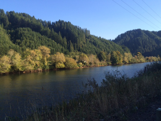
 I started my day with a hefty bag of cheese curds from Rumiano, a famous cheese factory in Crescent City. That fueled my ride from Crescent City through Jedidiah Smith State Park, Hiouchi and Gasquet along the Smith Rive Canyon is a spectacular one, but there is no relief to going up, up, up. I rarely needed my granny gear, but reaching false peak after false peak is a grueling game that gave me plenty of opportunity to witness my false perception of grade. When a 4% rise levels off to a 2% rise, the road appears to go downhill, so why am I still only logging 8 miles per hour?


All the pain was more than worth it, as the Smith Rive Canyon is a gorgeous place, the weather was perfect, and the traffic as accommodating as a cyclist can expect on such a narrow road.
 I stopped in Gasquet where firefighters had set up camp in the local airport. The last two days of rain helped dampen the danger, the fire warnings slipped from ’Extreme’ to ‘High’. The firefighters are an array of National Park Service employees, National Guard, U.S. military, and contract services from all over the country. I talked with a guard from Nebraska and cook from Texas who were both preparing to go home within days.
 Beyond Smith Canyon I descended into the Illinois River Valley of Oregon, a place rich in hippie vestiges. At Cave Junction I stayed with my first couchsurfing host (as opposed to warmshowers host). Meadow lives in small conservation cooperative. She invited some of her neighbors for dinner. We enjoyed crispy rice with Portobellos, green beans with almonds, and a robust salad, along with incredible raspberry cobbler, and talk about tomorrow that lasted well into the night.


September 18, 2015
Trip Log – Day 135 – Crescent City, CA to Orick, CA and back again
 September 17, 2015 – Sun, 60 degrees
Miles Today: 52
Miles to Date: 7,039
States to Date: 24
Today I basked in the glory of the redwoods. My route was out and back; down the coast to visit Redwoods National Park and then return to Crescent City before heading East tomorrow. Several locals warned against cycling the stretch from Crescent City to Klamath, 22 miles of gorgeous shore with tight curves and zero shoulder. I followed their advice and took the bus ($1.50 each way, half the passengers cyclists) and continued south from there. This turned a 90+ mile day into a 50 mile day, and it was fun to take the curves on 101 at motor speed. I arrived at Klamath at 8:30 a.m. The overnight rain had turned to fog as I crossed the Klamath River.

The mountains lay before my like Shangri-La as I began the six-mile trek up 101 and the Drury Road bypass through Prairie Creek State Park.

Redwood forests remind me of Hong Kong; impossibly tall structures hovering above a cacophony of ground level activity. I am constantly torn between looking skyward or exploring the dense fauna at eye level. The trees stand so independent, yet so close; a community of solitary objects. In fact, redwoods have shallow, wide root systems and no taproot. Their foundations are intertwined. They hold each other up. Like us, they are less independent than they appear.


 Of course I had to stop at the sign that read, ‘Big Tree’. It is among the grandest: 1500 years old; more than 300 feet tall; over 21 feet in diameter. The base circumference is 68 feet. This tree was one of the triggers that propelled the Redwood preservation movement in the early twentieth century when a local tried to cut it down and polish the stump into an outdoor dance floor.

 The descent along Drury Road was one of my most pleasant glides all trip. I rolled along at 12 miles per hour with minimal pealing for miles until I arrived Elk Meadow, where a big guy was grazing near the edge of the road.
The State of California began preserving Redwoods over one hundred years ago, but Redwoods Naitonal Park wasn’t formed until 1968. Lady Bird Johnson was an advocate for the park, so I wanted to see the grove named in her honor. Most redwoods are nestled between the sea and the hills, where they catch the most fog. But Lady Bird Johnson Grove is on a ridge. The redwoods are less dense, but the variety of other plants is greater. Unfortunately, it is also a steep climb: 1200 vertical feet in less than three miles. It was worth the effort, and I had a nice break walking my bike along the 1-1/2 mile trail.


 I am still mesmerized by how these behemoths fall – there seems so little room for them to land. But when they land across a path, the Park Service just cuts a slice through for us to pass.
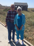 I white-knuckle braked my way down from Lady Bird Johnson Grove, pedaled through Orick and stopped for lunch at the beach, where I met the sweetest couple from West Virginia.

The ride back to Klamath was easy. The post-storm winds were mostly at my back though the sky was blue. I hiked a few more redwood trails, and took a parting photograph from the Klamath River Bridge. Within seven hours the morning fog lifted, the sun shined, and the late day clouds were setting in.


Trip Log – Day 134 – Crescent City, CA
 September 16, 2015 – Rain, 60 degrees
Miles Today: 18
Miles to Date: 6,987
States to Date: 24


I woke to rain, a light spattering on my roof that grew in intensity throughout the morning. I had planned to go to Trinidad – 70 miles along the coast. But nothing gelled. I didn’t get a warmshowers host or other accommodation. Besides, my host told me the redwoods three miles away in Jedediah Smith State Park were as magnificent as any. I didn’t realize that Redwoods National Park is actually a series of parks, and the redwoods north of Crescent City are as grand as any. So, instead of enduring a wet cycling day, I spent the morning enjoying my cozy cabin and pedaled out after noon, when the showers turned to a trickle.


Seeing redwood trees was one of a handful of natural sites I wanted to encounter on my trip. The tallest living things on earth do not disappoint. They are immense and majestic. I snapped picture after picture in vain; it’s impossible to capture their character in a frame. I finally added my bicycle just to get some scale. I was also amazed by the ones that had fallen over. They are so big and so close, it’s hard to believe they find a place to lie flat, but they do.


I rode into Crescent City proper, which is an interesting town in an abstract way. It gets more tsunamis than any city on the west Coast; the entire downtown was wiped out in 1964. Given the quality of architecture in the 1960’, what was built in its place is pretty banal. What is interesting is the system of jetties they’ve built to protect the harbor and their advance warning system.


 Although the forecast called for more rain, the skies brightened, so I went out to the jetties and toured town before finding a nice motel for the night. There are few tourists here mid-week with bad weather, so I got a room with a water view. Pretty classy for me.


September 16, 2015
Trip Log – Day 133 –Gold Beach, OR to Crescent City, CA
 September 15, 2015 – Overcast, 60 degrees
Miles Today: 65
Miles to Date: 6,969
States to Date: 24
 California! I rolled over the line in late afternoon and entered The Golden State – home to one in nine Americans, each of whom is increasingly thirsty. As I entered, fires raged in the State after a long, dry summer. But I brought with me the forecast of rain, a forecast heralded like a newborn over the past few days. If the word California means anything, it means hope. It’s where we head when we need a fresh start. Everyone here is hoping these rains will do some good, to extinguish fires in the short-term and quench thirst in the long.
 Paul Hempel and Bruce Newman sent me off from Gold Beach with a huge breakfast. The ride along the Oregon coast was beautiful, though the wind turned into my face as the weather shifted. Much of the Oregon coast is preserved, with well-marked viewpoints along the way. I stopped to enjoy many of the diversions.
 I took a break at the Brookings Library and continued on to California. I crossed the border and passed the requisite agricultural station. Immediately, there was much more development. More oceanfront houses, more farms, more places stacked on the hills. I turned off US 101 just beyond Smith River, passed the forbidding Pelican Bay Prison, and arrived at my warmshowers hosts.
 Hope and Dave live on a two-acre orchard with a small house, shed building, and cottage out back. Dave had just finished installing batt insulation from the outside of the west wall. He asked me to help hold a 4×8 sheet of plywood at the corner. I suggested that the insulation would be ruined if the rain forecast proved true, so we spent an hour getting all the sheathing in place. It felt good to work for my supper of homegrown squash soup and thick, fresh bread. The simplest and most satisfying meal of my trip, topped it off with dark chocolate cocoanut patties for dessert.
 After dinner I tucked into the back cottage, two charming rustic rooms with a comfy bed.

September 15, 2015
Trip Log – Day 132 – Coos Bay, OR to Gold Beach, OR
 September 14, 2015 – Overcast, 60 degrees
Miles Today: 76
Miles to Date: 6,904
States to Date: 23
The pattern of clouds and sun on the West Coast is opposite what we usually get back East. At home our mornings are often sunny, but once the clouds arrive, they stay. Here, mornings are often cloudy but can evaporate to bright sun later in the day. Today was cloudy from the start and stayed that way until late afternoon. Then the sun came out for a gorgeous sunset and a night sky was full of stars. It was overcast the entire time I cycled; the first time that I kept my windbreaker on all day.


I took the coast road out of Coos Bay through Charleston, a picturesque fishing village that appreciates the fourth food group.
 I climbed Seven Devil’s Road, so named because it has seven steep climbs, marked on the pavement for cyclists. Between climb five and six the road stays high above the trees for several miles. Even on a cloudy day, the view west reveals rows of distant mountains.
Between Bandon and Port Orford, US 101 tucks inland and passes all variety of vacation kitsch. I was intrigued by all of the chainsaw wood carving places and stopped at Something Awesome, which had some of the best supersize wood sculptures. Not sure who buys them or where they get displayed, but they sure are fun.


After a terrific lunch break at TJ’s Cafe in Port Orford I couldn’t help but climb the sign and arrow painted on the road. At the top of the hill – bam – the ocean that I had not seen for a few hours spread out before me.


The last fifteen miles along the coast and around the base of Humbug Mountain were gorgeous. The lowering sun dazzled the water. I overshot the turnoff to my friend Paul Hempel’s house, but hardly minded because the view of Humbug coming back north was incredible.


 Turns out, Paul and his husband Bruce’s house is on a hill with deadeye views of Humbug, so I got the see the sun play off the mountain and the sea for several twilight hours. Bruce and Paul have a fascinating house and shop with gardens and pools. Paul retired recently and has taken to being a gentlemen farmer very well.
 Bruce is a renowned restorer of player pianos and orchestrions. If you don’t know what that is, neither did I, but hearing a technical device play six or eight different instruments is a delight.

September 14, 2015
Trip Log – Day 131 –Florence, OR to Coos Bay, OR
 September 13, 2015 – Sun, 65 degrees
Miles Today: 55
Miles to Date: 6,828
States to Date: 23
I spent the entire day rolling along US 101 within the Oregon Coast Dunes National Recreation Area. Tall trees shade the highway almost the entire way, while my diversions to the shore brought me into bright sunshine. I took a leisurely morning and left Florence when the mist cleared. Riding later in the day, which I avoided all summer, is not so bad when the thermometer never tops 70.

Looking back on Florence, a lovely seaside town.

In places the dunes roll back to inlets behind the shore.


I went to the beach, climbed the dunes, and met a group of free spirits traveling in a van. Was there a word for folks like this before hippies? It seems so dated. Also met a guy in a khaki uniform sitting watch on the dune top to guard plovers, which are coming back in Oregon.
 Further on was a terrific lighthouse and space of beach for whale watching. I am too inpatient to stand and wait for whales, so I kept on.

Near Coos Bay the forest and sand just seem to collide.

The Conde McCollough Memorial Bridge brought me into North Bend, a cool town.
 I was amazed at this giant tanker being filled with pulp. Apparently it is cheaper to fill ships with pulp, send them to Asia to make paper, and then send the paper back here. Our world is so nuts; sometimes all we can do is laugh.
Got into Coos Bay at a reasonable time and found a nifty little motel for the night.


September 13, 2015
Trip Log – Day 130 – Eugene, OR to Florence, OR
 September 12, 2015 – Sun, 75 degrees
Miles Today: 78
Miles to Date: 6,773
States to Date: 23
Any Saturday that begins with coffee on Kurt’s sunny deck bodes well. It was difficult to leave such a serene place and such a delightful man, but I had a breakfast date with my most faithful reader, Sherri McCutchen. Sherri invited her son Zander Chanin to join us at Brail’s A Eugene institution. The food was good, the conversation even better.


I didn’t get on the road until eleven. The day was fair, the breeze light, the scenery lovely. I stopped at a car show in Crow. My favorites were a pair of truly classic 1953 Chevy Bel Airs, but nobaody asks a guy in bike shorts his opinion of cars.


I took a wrong turn and went three miles down a gorgeous valley before I realized my error. Back on track, I headed west, enjoyed ten miles of excellent riding without encountering any other vehicles, and then reached the huge Noti sawmill. I took a break at the Noti Market and met Tom a sawyer who was keen on my journey.
 I joined Highway 126 West, which turned out to be a much better road than I had been warned. In late afternoon I stopped at a country park and met a couple I had contacted as potential warmshowers hosts. They were heading east (which is why they could not accommodate me) but we had a nice visit. One more climb to the tunnel, which is narrow but the flashing bicycle light warned any cars or trucks about me. Traffic was so light that no one even approached me in the tunnel.
On the far side the air was salty, the breeze brisk. After a long down slide, the highway paralleled Siuslaw River for twelve miles to Florence. There was a staunch headwind, but I moved strong, motivated to arrive before dark.
I stayed in a fine motel but the Internet didn’t work and in Indian-style the proprietors chose to blame my computer rather than their system. I went elsewhere, my computer found Internet just fine, and I got to see a bit of Florence at night, thought I still haven’t been to that famous Florence over in Italy.


September 12, 2015
Trip Log – Day 129 – Eugene, OR
 September 11, 2015 – Sun, 85 degrees
Miles Today: 10
Miles to Date: 6,695
States to Date: 23
Today I explored the University of Oregon and Eugene. I had morning meetings to discuss tomorrow with the Admissions and International Students office, ate a superb schwarma at Caspian, decided to become an undergraduate again to study Volcanology, and got a personal tour through the art museum with Associate Director Kurt Neugebauer.


Kurt hosted me for the evening. He invited three other friends for a dinner of local delicacies (including smoked tuna and prawns), which we capped off by going out for dessert at Sweet Life, a decadent and popular dessert bar. Then we drove up to Skinner’s Butte to see Eugene in its nighttime glory.


Like many college towns, Eugene is full of interesting people. Unlike many college towns, it doesn’t have a particularly inviting physical form. Apparently the 1960’s and 1970’s were unkind to Eugene. First, they tore down much of the city center and what remains is a hodgepodge. Then, they built blocks and blocks of squat ranch houses, which spreads the city out. More recent hillside houses have great distant views. But at a cycling level, Eugene is not a pretty place. However, at night, on a hill overlooking lights with a bunch of nice people after a yummy dessert, those shortcomings disappear.


