
Paul E. Fallon's Blog, page 62
October 4, 2015
Trip Log – Day 150 – Midpines, CA to Fresno, CA
 October 2, 2015 – Sunny, 90 degrees
Miles Today: 77
Miles to Date: 7,981
States to Date: 25
Today I sing an ode to Surly, my phenomenal bicycle. I started the day in the mountains. Google suggested a route of local roads that shaved five miles, and 3,000 vertical feet, off the highway route. Ever leery of dirt roads I vetted the route with the manager of the hostel. She explained that the roads were paved but advised against them since they had no shoulder. She was right in that the roads had no shoulder, or even a yellow line. But since no cars overtook me in over 25 miles, road width was not a problem.
 Unfortunately, she was incorrect about pavement. Over fifty miles on county roads, about ten miles were gravel. But Surly handled the ruts, soft patches, and skull-shattering serrations shaped by pick-ups with her usual dependability.

 I discovered a new phenomenon: people living in trailers with a small utility building on their property. Permanent pace for water and power, movable for people.
 I traveled from mountains to foothills to rugged chaparral; one of the most beautiful rides of my trip. I had a good lunch break at the Raymond General Store, and then continued through ever-gentler hills, ever less vegetation. Twenty-five miles outside of Fresno I joined Highway 41, and was glad I didn’t take that busy road the entire route.
 The most challenging cycling is always getting into and out of major cities, but Fresno set a new standard for confusion. When 41 turned into a freeway, I was diverted onto Business 41. A few turns, no markings, and I was heading west on Avenue 9 in the company of inpatient drivers. I about faced. A river separated me from the city. My map showed Avenue 9 crossing under the freeway where an old bridge spanned the water, but the road did not exist. Instead, there’s a new children’s hospital. At the far end of campus I spotted a bike path. I needed to get on that! Unfortunately a tall fence divided me from my desire. Eventually, I accessed the bike path by cutting through the hospital’s helipad. Against the rules, for sure; possibly against some law, but it got me onto the path, over the bridge, and into Fresno.


I saw my first olive trees, which are a beautiful silvery green. Across the road a huge development was under construction. If we don’t have enough water to grow crops, we can pave the groves.
 South of the river, everything was sun and palm trees. Fresno is my first place with a Southern California vibe: wide streets, big cars, harsh sun and expansive ranch houses that march on for miles. A new variation on the American Dream, and so very appealing.


October 3, 2015
Trip Log – Day 149 – Yosemite National Park to Midpines, CA
 October 1, 2015 – Rain, 60 degrees
Miles Today: 46
Miles to Date: 7,904
States to Date: 25
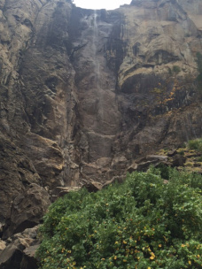
 Yosemite Valley is perfect to see on a bicycle. After a breakfast among ‘townies’ who cobble together a living as climbing guides, I spent the morning rolling through the valley and stopping at the sights. Perspectives changed as the sky went from rain to clouds to patchy sun. I took the Valley Loop Trail to Yosemite Falls, El Capitan, and Bridal Veil Falls.
Solid clouds formed to the east, so I decided pedal through them before they entered the park. Eight miles of steep downgrade in heavy, windless rain. More water splashed off the rocky cliffs than I saw at the signature falls. At the 8% grades, I stiff legged by right heel on the pavement through streams washing across the pavement. I pulled into El Portal Market to dry off. Their coffee stilled my shakes; their chicken salad filled my belly. Other folks stopped by to chat and recounted that our rain was snow, stranding travelers, on Tioga Pass. With my usual luck, I managed to cross the Sierras one day ahead of winter.
By three the weather cleared and I continued on to Midpines where I had a tent cabin reserved at Yosemite Bug Hostel, a very hospitable place with cozy cabins, great showers and tasty coconut squash soup to kick off a delicious dinner.

The north wall of the canyon.

Along the Yosemite Loop Trail

El Capitan’s long face.


Looking north up the valley floor

El Capitan through trees. / Bridal Veil Falls

Beyond the park, heading towards Midpines

The oldest rocks in the Yosemite Valley


Trip Log – Day 148 – Bridgeport, CA to Yosemite National Park
 September 30, 2015 – Overcast, 75 degrees
Miles Today: 96
Miles to Date: 7,862
States to Date: 25
At 7:00 a.m. I left my nifty cabin along Virginia Creek. At 7:00 p.m. I was eating dinner in Curry Camp Lodge between a trio of Chinese girls writing post cards and a pair of Austrian climbers who had just scaled El Capitan in six days. In between was a tale of determination overcoming faulty planning.
 I’d heard there was a good restaurant in Lee Vining, twenty miles from Virginian Creek Lodge. I decided to ride there, eat, and then tackle Tioga Pass to Yosemite. I was careful to check the grades over Tioga Pass, but failed to check the first part of my route. Eight miles straight up to Conway Pass on an empty stomach makes for an irritable cyclist.
 Even so, I could appreciate Mono Lake shimmering in the morning light.
 It was eleven a.m., with only twenty miles under my belt, by the time I finally ate and started up Tioga pass. My mind spun with alternate plans – no way would I make it 80 miles to Crane flat Campground on the other side of the Sierras. Other campgrounds existed once I reached the park.


Tioga Pass from east to west is a long, steady, picturesque climb. I reached the summit, and Yosemite entrance, at 1:30 p.m. Over the next 48 miles I had 3,000 feet of fall; perhaps I could make it to Crane Flat. Tioga Pass is a seasonal road that will close within a month. However, the services along the way were already shuttered. Getting to Crane Flat was an imperative, not an option. Still, I enjoyed Tuolumne Meadows and Olmstead Point, my first view of Half Dome.


Each decent gave me confidence I would make it before dusk; each climb gave me despair. Finally, at mile 64, the road turned to fresh pavement and a steady downhill. For sixteen miles I coasted at 20 to 25 miles per hour. Crane Flat turned out to be just s deserted as other areas, so I kept on rolling down.
 There are three tunnels on Route 140 into Yosemite. I came out of the first one and realized immediately what all the fuss is about. Yosemite is breathtaking; sculptured and muscular. Architecturally, it is Gods masterpiece.
The rest of my ride into Yosemite Valley was a joy, though it was too late to stop at the sites. Leave tomorrow for that.


Trip Log – Day 147 – Carson City, NV to Bridgeport, CA
 September 29, 2015 – Overcast, 80 degrees
Miles Today: 88
Miles to Date: 7,766
States to Date: 25
‘The usual’ at Red Hut Cafe in Carson City is the definitive carb load: a pair of sunny side fried eggs with hashbrowns plus biscuits with gravy. After that fuel, I was ready to roll back into California, along the eastern side of the Sierra Nevadas.

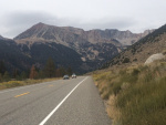
The best way to appreciate mountains on a bicycle is to glide beside them rather than pedal through them. Today I got my preferred arrangement at the start and end of my day. Carson Valley is broad and flat, with dynamic mountains rising to the west. The shoulder on US 395 is good, so I focused to my left and hardly noticed all the traffic on the busy road.
 Minton is a cute town with a vintage gas station. In true Nevada fashion, it’s been renovated into a casino.
On my first rise of the day I stopped to shift from morning windbreaker mode to daytime sunblock mode when I ran into two senior citizens in a cruiser marked ‘Volunteer’. Turns out Douglas County has a full crew of retired police (or wannabe police) who volunteer to patrol the area, check on vacationer’s houses, and investigate suspicious VIN’s. Don and Nancy looked very official and clearly enjoyed keeping Nevada safe. Before I continued on, a local cyclist came upon me and recommended I stop at Walker Burger for lunch.
 After that break, and anticipating a good burger, the ride over the ridge and into Antelope Valley was a breeze. Topaz Lake, on the Nevada/California border is spectacular. I’ve decided a cyclist can smuggle any kind of vegetable into California: today was my third pass through border inspection and I got a ritual wave through. I’d logged over 50 miles when I got to Walker Burger; I was hungry. Unfortunately, it’s closed on Tuesday. That left a general store with fewer choices than a 7-11. I opted for a favorite fallback when I need energy, calories, protein and hydration: a quart of chocolate milk plus a banana and a donut. It’s weird, but it covers all the bases.

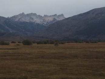
My improvised lunch did the trick. I climbed eighteen miles through a steep canyon, across sage-covered hills, and between jagged peaks before I crossed Devil’s Gate Pass and sailed twelve miles down to Bridgeport. Once again, I was treated to majestic mountains on my left as I rode along a verdant, level meadow.
 My tent cabin at Virginia Creek Lodge was love at first sight. Why don’t other places have these? Super cute, affordable, clean, and functional. I settled in and enjoyed a good shower at the camp building. On my way to dinner, the sky shed the day’s grey clouds and glowed in the sunset. The lodge restaurant is quite good: I finally got that burger I’d craved all day.


Trip Log – Day 146 – Reno, NV to Carson City, NV
 September 28, 2015 – Sun, 80 degrees
Miles Today: 49
Miles to Date: 7,638
States to Date: 25
 Instead of following an ordinary Google route out of town, my warmshowers host Sherry gave me a scenic route out of Reno, though I didn’t leave town until after noon. Having interviewed a wedding chapel owner this weekend, I followed up with a quickie divorce service this morning. I lose my senses and get married over the weekend; it’s good to know I can get it annulled almost as expeditiously.
I was assured to see peacocks among the 2-5 acres ranchettes scattered across the valley southwest of Reno, but they didn’t strut as I pedaled through enclaves that looked like photo shoots for Sunset Magazine. Sherry guaranteed I’d see wild horses as I climbed Geiger Grade to Virginia City, but my track record on seeing wildlife continues to be lousy; no wild horses showed themselves.


 Nevertheless, the rigorous climb to Virginia City was worth the stark, expansive scenery. The final reward was reaching Virginia City and visiting the remnants of the Comstock Lode. Virginia City manages to be touristy without being sanitized.


The decent towards Carson City is a 15% grade, but trucks and RV’s are prohibited, so I could let the brakes out a bit. I rolled into Carson City well before the sun slid behind the mountains. It’s the least impressive capital city I’ve visited. Perhaps that’s appropriate in a state with a strong libertarian streak.


September 28, 2015
Trip Log – Day 145 – Reno, NV
 September 27, 2015 – Sun, 90 degrees
Miles Today: 13
Miles to Date: 7,589
States to Date: 25
Today was a rest day, a day to explore Reno away from casinos. I rode up Windy Hill to see the city from up high in daylight, attended a Unitarian-Universalist Forum on income inequality with my Saturday night host, spent several hours preparing the logistics for my trip through Yosemite – a place that calls for strategic cycling, enjoyed a buffet lunch where I met a gang of medical residents from India, took a writing break at the classic 1960’s Reno Library, and then climbed Skyline Blvd for an engaging evening with my warmshowers hosts. We watched the lunar eclipse from their patio overlooking a canyon.

Reading area of Reno Public Library


September 27, 2015
Trip Log – Day 144 – Reno, NV
 September 26, 2015 – Sun, 90 degrees
Miles Today: 11
Miles to Date: 7,576
States to Date: 25
If I blasted into Nevada in a Maserati I would go to Las Vegas. But since I’m on a bicycle I’m drawn to more intimate places. A local told me, “Reno is Sin City; Las Vegas is beyond sin.” Reno fits my desire to explore the state that invented the economy of vice at a cycle friendly scale.


I spent the day downtown. The main streets were blocked off for Street Vibrations, an annual motorcycle rally. I interviewed a couple that run a Wedding Chapel and a dealer in a casino. I stuffed myself at the Eldorado Buffet and strolled among so much leather the scent permeated the dry desert air. The crowd was 80% barrel bellied, 20% string bean thin, and 100% weathered. Festival booths sold all sorts of paraphernalia; much of it unprintable in this family blog, but it struck me that a moisturizer vendor could make a killing. The music was great, and motorcyclists give bicyclists a different kind of respect. We have a two-wheel bond but the commonalities pretty much end there.


I’ve been to Reno once before, in 1978. The changes to the city reflect changes seen in other cities over that time. The city has expanded out while downtown has shrunk. The economy is more diversified – only 30% of Nevada’s revenue comes from gaming these days – but casinos still define the culture. Reno was hit hard when Indian gaming moved into California in the early 2000’s, and hit again by the 2008 recession. More than half of the casinos went out of business, and newer ones are not locating downtown. The Atlantis and the Peppermill are standalone enclaves on the outskirts of town – fully enclosed destinations with huge parking lots. But what remains downtown turns out to be a great size for an single event to dominate the entire area. Street Vibrations owned center city.


In the late afternoon I rode along the river; Reno has some cool large scale sculptures. I took Surly to the Reno Bike Project for a new chain, where I met kindred spirit two-wheelers keen to share adventures. Then I pedaled out to my host for the evening. Bob is a member of Servas, not warmshowers, and it was interesting to learn about a different program for inviting travelers into private homes. After dinner Bob drove me around town. Up to Windy Hill for the nighttime view, and over to Atlantis where we enjoyed gelato amid casino whistles and lights.


Trip Log – Day 143 – Susanville, CA to Reno, NV
 September 25, 2015 – Sun, 90 degrees
Miles Today: 88
Miles to Date: 7,565
States to Date: 25
I had been warmed that US 395 to Reno had gyrating, variable winds, so I rolled out of Susanville at first light when winds are light. The warnings were supported by big yellow danger signs along the road, but my strategy proved sound. I logged fifty miles along a generous shoulder through stark desert landscape before noon.
 I encountered two cyclists on the road. The first blew by me in his black spandex without a word. The second was a grey haired guy in work shorts and a dirty T-shirt, walking his bike along the gravel. I stopped and asked if all was okay. JR is a homeless person from west of Redding en route to Reno and a warmer winter. “I got another flat, a slow leak. That’s five so far this trip.” One look at his lightweight bike, burdened by all of his possessions, explained the problem. “Don’t worry, guy, I’ve had seven flats.” I didn’t mention mine were over 7,000 miles instead of 200. JR let me give him a Presta valve adaptor so we could pump his tire up, but he wouldn’t take any food or water even though I knew he had less than I carried. I respected his pride and wished him well.
Although my legs keep moving to propel me forward, the journeys in my mind often cover greater range. I couldn’t decide who was the greater challenge in our world: the man who whisked by without notice or the one who couldn’t possibly cope. I mulled that one over, then solved the world’s problems and discovered eternal love at least three times before lunch. My musings lent meaning to the message tucked into the guardrail that I leaned my bike against for lunch:

 No shade today; I snacked with sagebrush for companions and then shouldered on. True to form, the wind was much stronger after lunch, which just gave me more opportunity to upright our planet – in my mind at least. This was my fourth consecutive long distance day, and I was much more patient than earlier days.
I arrived in Reno along with several thousand motorcycles for a rally. Since it’s a city that never sleeps, I decided to do some sleeping and checked into a local place for an early night. Tomorrow is time enough to explore The Biggest Little City in the World.


Trip Log – Day 142 –Bieber, CA to Susanville, CA
 September 24, 2015 – Sun, 90 degrees
Miles Today: 74
Miles to Date: 7,477
States to Date: 24
The world is immense. I am traveling across a part of California I never even knew existed. It is gorgeous, it is challenging, and it is really, really big!
Today I passed through a series of valleys, at least six, surrounded by mountains, which, of course, needed to be scaled. Each valley was higher than the last, so climbs up exceeded descents. The largest, Eagle Lake Valley, was above 5,000 feet in elevation. All of that climbing finally culminated in a four-mile white-knuckle descent into Susanville. All my hard pedaling evaporated into my brakes!
I treated myself to a delicious meal at the local Mexican place. An $8.25 pork Chile burrito plate in Susanville beats any Mexican entree in New England.

The woods are delightful.

Some of the valleys appear to be former lakes.

Mount Shasta will not go away; barely visible over 100 miles away.


I ate lunch under a shady pinion with beautiful sagebrush nearby.

Eagle Lake is a fragment of what it was. My first evidence of California’s water troubles.


Trip Log – Day 141 – Mount Shasta, CA to Bieber, CA
 September 22, 2015 – Sun, 90 degrees
Miles Today: 78
Miles to Date: 7,383
States to Date: 24
 Yesterday I measured my distance as Mount Shasta emerged. Today I kept catching her behind my shoulder.
Everything was easier today: fewer miles, shallower climbs, more benign wind, but three marked summits over 78 miles is still challenging riding. The day began with four miles straight up California Route 89 to McCloud Summit, then a quick descent into town, where I had an early lunch for fear of no other services.
 The second ascent was more gradual, through Trinity-Shasta National Forest, but ultimately went higher. There was no shoulder, but I scooted onto the soft gravel edge when the logging tricks didn’t give any ground. After I turned on to a county road, things got much more fun: a four-mile descent in a straight line – no traffic, no brakes required – followed by fifteen miles through the gorgeous Fall River Valley to McArthur, where there was an unexpected market and very friendly people.
In the heat of a cloudless sky I had to scale Long Summit, the last and highest of my day. I got flat number seven a third of the way up, but all repaired well. I pedaled to the top, and before turning east, caught my last glimpse of mighty Mount Shasta, more than seventy miles away.

I arrived in Bieber just after five, thankful that the only store was still open. Bieber’s not the kind of place one loves on sight, but everyone I’ve met here has been open and kind. When the Portuguese immigrant motel owner heard about my trip she said, “Well, I can only charge you half price.” I protested, but she insisted. A nice room, hot shower, fresh coffee and Internet for twenty-five dollars; cash. I wanted to take her picture, but she was insistent THAT would not happen.


